Chapt. 11. Section 1. Central America and the Carribean
|
|
|
- Molly Hicks
- 5 years ago
- Views:
Transcription
1 Chapt. 11. Section 1 Central America and the Carribean
2
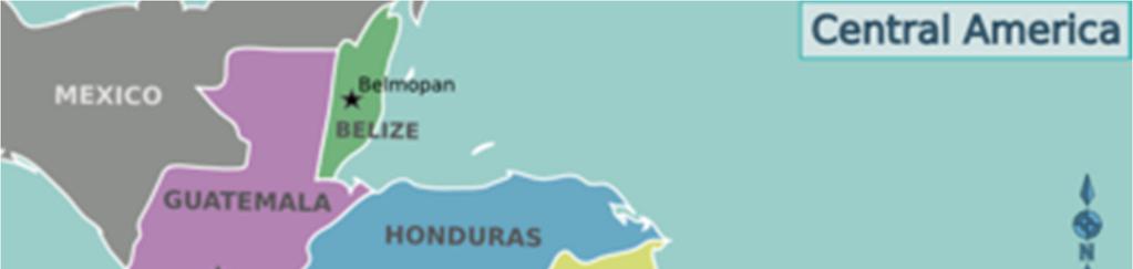
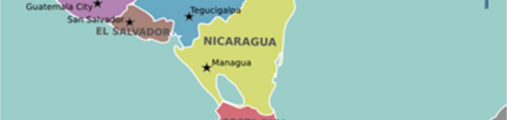
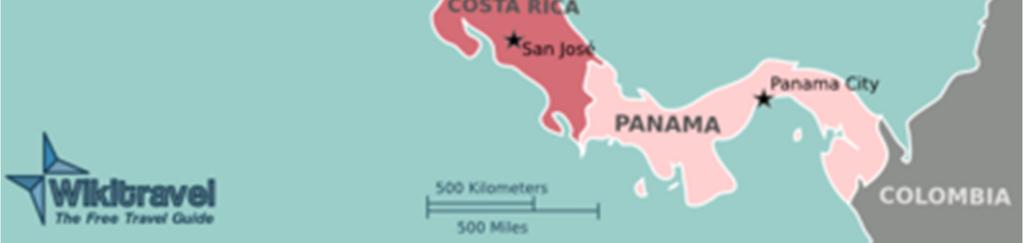
3 Central America The small region of Central America curves between the giant land masses of North America and South America. Central America is an isthmus a narrow strip of land, with water on both sides, that connects tow larger bodies of land. Central America thus forms a lad bridge between the two continents. Until 1914, Central America greatly hindered movement of people and goods between the Atlantic and Pacific oceans. In that year, the opening of the Panama Canal made it possible for ships to cross the isthmus and sail between the two oceans. Many days were saved because ships did not have to travel thousands of extra miles around the tip of South America. Seven countries occupy this narrow, curving strip of land between Mexico and Colombia. Beginning in the north, they are Belize, Guatemala, Honduras, El Salvador, Nicaragua, Costa Rica, and Panama. As the map on page 238 shows, these countries are small in area, with a combined land area only about one fourth the size of Mexico. However, packed into this small region is a diverse physical and human landscape as complex as the designs in traditional Indian clothing. This great cultural complexity explains many of the political, social, and economic challenges that Central America faces today.
4 Landforms and Climates Naturalist Jonathan Evan Maslow captured the physical diversity of Central America in this description of Guatemala: Up and down, round and round, the countryside never stayed the same more than a few miles at a stretch Granite heights that looked clawed by blind and angry titans [giants] pitched into patches of lowland rain forest It was like an entire continent stuffed as in an expertly packed suitcase into a country the size of Massachusetts. This narrative could be used to describe many of the countries in this region. While the landscape of most of Central America is widely varied, even this diverse landscape can be divided into regions. Three major landform regions make up Central America the mountainous core, the Caribbean lowlands, and the Pacific coastal plain. Each landform region has its own climate. The Mountainous Core As in Mexico, mountains run the length of Central America, some towering more than 13,000 feet (4,000 m) above sea level. These rugged mountainous core. Elevations between 3,000 and 6,000 feet (900 and 1,800m) have a year-round, springlikeclimate, free of frosts but cool enough to grow corn and coffee. Above 6,000 feet (1,800 m) the climate is cold. Because of frequent frosts, few crops other than potatoes and barley can grow at these high elevations.
5 Landforms and Climates Caribbean Lowlands On the eastern side of Central America, the mountainous core gives way to lowlands that edge the Caribbean Sea. The Caribbean lowlands have atropicalwetclimate hot and humid with year-round high temperatures and heavy rainfall. Northeast trade winds may bring more than 80 inches of rain in a year. Dense rain forest vegetation covers much of the land. The rain forest soil is not very fertile, limiting the corps that can be grown there. Pacific Coastal Plain Unlike the Caribbean Coast, the Pacific coast has a tropical wet and dry climate with savanna, or grassland, vegetation. The difference in climate on the two coasts is due to the moist winds that sweep from the northeast across the Caribbean toward Central America. These winds drop rain on the Caribbean coast and the eastern mountain slopes throughout the year. In contrast, the Pacific coast can depend on rain only in the summer. Volcanoes high in the mountains above the Pacific coastal plain affect the land. Lava flows and deposits of volcanic ash make Pacific coasts soils extremely fertile. Nicaragua s Pacific coastal plain has several freshwater lakes. The largest is Lade Nicaragua, a large oval lake scattered with small islands. Scientists believe that it was once a bay, cut off from the Pacific Ocean when a volcanic eruption created a ridge of mountains. Although the lake is fresh water, ocean creatures such as sharks and swordfish swim in its deep blue waters. Climatic Hazards In summer and early fall, tropical storms and hurricanes can strike. One of the most deadly was Hurricane Mitch, in October Hardest hit was Honduras, where torrents of rain caused flooding and mudslides. In some areas, entire villages were washed away.
6 People and Cultures As the map on page 247 shows, Central America is home to serveralethnic groups. Each group tends to be concentrated in a specific location. One reason for this is that throughout the region s history, the mountains have made it difficult for people to travel between areas and mingle with other groups Indians The people who have lived longest in Central America are the Indians. Each Indian group has its own distinct history, culture, and language. The largest number of Central American Indians live in Guatemala. There they make up more than half the population. Europeans and Mestizos Europeans arrived in Central America in the 1500s, when Spaniards conquered and colonized the region. Because of this history, Spanish is the official language in almost all of Central America. The largest European settlement today is in Costa Rica, where 90 percent of the people are of European mostly Spanish descent. Another large group in Central America s population consists of people of mixed European and Indian background called mestizos. Both El Salvador and Nicaragua have large mestizo populations. African Descent People of African descent are an important population group on Central America s Caribbean Coast. Some are descendants of African slaves, who were brought to Central America as early as the 1500s. Most, however, are descended from people who migrated to the region from the Caribbean islands in the early 1900s. They came to work on banana plantations or to help build the Panama Canal.
7 Wealth and Poverty Most of the people of Central America are very poor. The wealthy constitute only a tiny percentage of the total population. Most them are plantation owners and are European or mestizo. The rich dominate government and politics in the region. At least two thirds of all Central Americans are poor, with little political power. They include millions of farmers who have little or no land, and laborers who earn low wages on plantations or in factories. Most are people of Indian and African descent. The middle class is a small but very important third category in Central America s social structure. This group includes farmers who own small, noncommercial farmland and some employees of urban industries and services. Central America s middle class is a growing population, but it remains small in comparison with the millions of poor people. Economic Activities The majority of Central America s people earn their living by some kind of farming. In Guatemala and Honduras, farming employs more than 50 percent of the people. Most of the rural population of Central America lives by subsistence farming. On small farms, using only their hands and a few basic tools, families labor to grow enough corn, beans, and squash to stay alive. In sharp contrast are the large plantation owned by wealthy families and corporations. Plantation owners hire workers at very low wages and bring in the newest machines, fertilizers, and pesticides to produce cash crops of coffee, bananas, or cotton. Most of these crops are shipped to the United States or Europe. These cash crops account for well over half of Central America s income from exports.
8 Political Conflict Picture deep-red coffee beans ripening in the warm sun and workers on ladders reaching to cut clumps of bananas from the trees. Now imagine the crack of gunfire and the sound of soldiers scrambling through mountain forests. For years, these two images have contributed to the nature of Central America. Armed conflicts have troubled Central America for much of its history. Each nation has specific problems, but some causes for conflict apply to the region as a whole. One important problem is the shortage of available farmland to meet the needs of a growing population, made worse by the unequal distribution of useable land and limited access to productive technology and methods. Nicaragua From 1936 to 1979, the Somoza family controlled Nicaragua through corrupt means, changing election results and manipulating the economy. In 1979, a group called the Sandinistas (Sandinista Front for National Liberation) led a movement that overthrew the Somoza government. The Sandinistas governed the country under a socialist system, taking property from landowners and giving it to their supporters. Government control of agriculture and industry caused lower production and a drop in exports. Soon other Nicaraguans, dissatisfied with these moves, tried to overthrow the Sandinista government, claiming it was turning the country toward communism. These guerilla fighters were known as the contras, from the Spanish word for against. Fighting between the two factions raged in Nicaragua and the borders of neighboring countries throughout the 1980s, causing thousands of deaths. A cease-fire brought a measure of peace in For the first time in the country s history, power passed peacefully in a free election in Another election took place in Nicaragua made slow but steady progress in rebuilding its economy until Hurricane Mitch struck in 1998, devastating crops and destroying many roads and buildings.
9 Political Conflict El Salvador Political instability and violence have troubled other countries in Central America. In El Salvador, as landlessness among ordinary people increased, wealthy landowners feared a popular revolition. They hired death squads to eliminate political opponents who wanted reform. Between 1979 and 1992, El Salvador was the scene of a bloody civil war that involved the army, the death squads, and antigovernment guerillas. More than 70,000 people, many of them civilians, died. In 1992 a peace agreement mediated by the United Nations ended the war. After peace returned, the economic horizon looked a little brighter, although El Salvador, too, was hard hit by Hurricane Mitch. Guatemala The most populous country in Central America, Guatemala has a political history similar to that of El Salvador and Nicaragua. After gaining independence from Spain in 1821, Guatemala was ruled by a series of caudillos, or military dictators. Following World War II, a liberal government was elected, ending the long-term dictatorship of Jorge Ubico. In the decades that followed, the military gained power. Civil war erupted in the 1960s as leftist guerilla movements challenged the harsh military regime. During the civil war, the government ruled the through the heavy hand of death squads who routinely tortured and murdered critics, including student and labor leaders. More than 150,000 people were killed and another 40,000 disappeared. Guatemala returned to civilian rule in the mid-1980s, although the military remained a powerful force behind the scenes. The crisis-ridden government of President Jorge Serrano Elias was outstedby the military in Congress then elected Ramiro de Leon Carpioto complete the term. A champion of human rights, De Leon worked to end government corruption and restore peace to Guatemala. The 30-year war tapered off in the 1990s. In 1995, a UN report blamed Guatemalan authorities for the majority of human rights violations. A peace accord was signed in 1996, ending the war, and a number of police and military personnel were arrested for their death squad activities. Free
Nicaragua versus Costa Rica?
 Nicaragua versus Costa Rica? Overview: Today I want to look at Nicaragua versus Costa Rica from both a destination for retiree s standpoint and for potential investment interest. First I'll provide some
Mexico. Chapter 10. Chapter 10, Section
 Chapter 10, Section World Geography Chapter 10 Mexico Copyright 2003 by Pearson Education, Inc., publishing as Prentice Hall, Upper Saddle River, NJ. All rights reserved. Chapter 10, Section World Geography
CHAPTER Latin America. Regional Atlas Study Guide. 2 Chapter A. As You Read. B. Reviewing Vocabulary
 CHAPTER 28 9 Many Th ew inventions new Regional Atlas Study Guide Latin America Directions: As you work through the Regional Atlas, complete the chart below by writing two details about each Latin American
UNIT 3 Extra Review for Chapters 9-11
 UNIT 3 Extra Review for Chapters 9-11 Mexico Central America Caribbean Islands Middle America is Central America, Mexico, and the Islands of the Caribbean Central America is a region within Middle America.
Why is the US industry and agriculture prosperous? The US industry and agriculture is so prosperous because it has many different natural resources.
 Ch. 1-7 Study Guide Why is the US industry and agriculture prosperous? The US industry and agriculture is so prosperous because it has many different natural resources. What likely drew immigrants to the
Mrs. Reifsnyder World Geography. Unit 8: Latin America Study Guide SOLs Addressed: WG. 1c, 2b, 3c, 4, 10b/c
 Mrs. Reifsnyder World Geography Unit 8: Latin America Study Guide SOLs Addressed: WG. 1c, 2b, 3c, 4, 10b/c Essential Questions: - In what ways do physical, economic, and cultural characteristics influence
Introduction to Africa
 Introduction to Africa Did you know? Africa has more countries than any other continent. The Sahara is a desert that is the size of the U.S. It s the world's largest desert. Most of the world s gold and
CHAPTER 12. South America. Section 1: Natural Environments Section 2: History and Culture Section 3: South America Today. HOLT World Geography
 CHAPTER 12 South America Section 1: Natural Environments Section 2: History and Culture Section 3: South America 1 Section 1 Natural Environments Objectives: What are the major landforms and rivers of
COUNTRY DATA: Costa Rica : Information from the CIA World Factbook! INTRODUCTION GEOGRAPHY
 ! COUNTRY DATA: Costa Rica : Information from the CIA World Factbook! INTRODUCTION GEOGRAPHY Location Area Central America, bordering both the Caribbean Sea and the North Pacific Ocean, between Nicaragua
LOCATION, CLIMATE, AND NATURAL RESOURCES OF MEXICO
 SS6G3 The student will explain the impact of location, climate, distribution of natural resources, and population distribution on Latin America and the Caribbean. a. Compare how the location, climate,
Economy 3. This region s economy was based on agriculture. 4. This region produced items such as textiles, iron, and ships in great quantities. For th
 Geography 1. This region has a climate of warm summers and snowy cold winters. 2. This region has a climate that is generally warm and sunny, with long, hot, humid summers, and mild winters, and heavy
11/16/15. Today s! Topic: " Latin America Independence Movement
 Classes begin at: 1st Block 8:35am 2 nd Block 10:05am Georgia Cyber Academy s mission is to provide an exemplary individualized and engaging educational experience for all students. Learning Target: I
The Northern Tropics
 The Northern Tropics The Guianas Countries Guyana, Suriname, French Guyana Culture reflects colonial history Official Languages Guyana English Suriname Dutch French Guyana - French Religions Suriname and
Chapter 20. The Physical Geography of Africa South of the Sahara
 Chapter 20 The Physical Geography of Africa South of the Sahara Chapter Objectives Identify the major landforms, water systems, and natural resources of Africa south of the Sahara. Describe the relationship
The Cuban Revolution and Guerrilla Movement in Mexico
 Warm up 1) Who lead Mexico to independence? 2) What as Simon Bolivar's nick name? What countries did Bolivar lead to independence? 3) I was an ex-slave who lead Haiti to independence, Who am I? 4) Which
WORLD GEOGRAPHY. Hector Rodriguez
 Mr. Chavira 9th Period WORLD GEOGRAPHY Hector Rodriguez P a g e 1 Table of Contents Latin America Page 2 o Maps Economic Map Page 3 Political Map Page 4 Population Map Page 5 Physical Page 6 o Notes Physical
6th Grade Third Nine Weeks Benchmark Assessment
 6th Grade Third Nine Weeks Benchmark Assessment Multiple Choice Identify the choice that best completes the statement or answers the question. Key Concepts 1 Latin America is located in the A Northern
STUDY GUIDE. The Land. Physical Features of Latin America. Chapter 8, Section 1. Terms to Know DRAWING FROM EXPERIENCE ORGANIZING YOUR THOUGHTS
 For use with textbook pages 193 198. The Land Terms to Know cordillera A mountain range that runs parallel to another mountain range (page 194) altiplano A high plain (page 194) escarpment A steep cliff
6th Grade Western Hemisphere Geography
 6th Grade Western Hemisphere Geography Multiple Choice Identify the choice that best completes the statement or answers the question. 1 Latin America is located in the A Northern Hemisphere. C Western
Many ecotourists visit the various natural habitats in Central America. Why do you think ecotourism has become so popular?
 Chapter 9 Middle America and Spanish Speaking South America pg. 252 287 9 1 Central America pg. 255 259 Connecting to Your World What is one country in Central America that promotes ecotourism? Many ecotourists
1st Period Mr. Chavira WORLD GEOGRAPHY. Hector Rodriguez
 1st Period Mr. Chavira WORLD GEOGRAPHY Hector Rodriguez P a g e 1 Table of Contents Latin America Page 2 o Maps Economic Map Page 3 Political Map Page 4 Population Map Page 5 Physical Page 6 o Notes Physical
Latin America and The Caribbean. A Closer Look.
 Latin America and The Caribbean A Closer Look. Mexico Capital: Mexico City The Location of Mexico Mexico is the second-largest country by size and population in Latin America.but the Largest Spanish -
The Aztecs and the Mayans were advanced in mathematics (in fact their calendar was more accurate than the European one at the time ) Mexico has a
 Mexico has a") México Notes on Mexico Two of the most influential cultures in Mexico were the Aztecs and Mayans. The capital of Mexico before Christopher Columbus arrived in America was Tenochtitlán. It was the capital
México Notes on Mexico Two of the most influential cultures in Mexico were the Aztecs and Mayans. The capital of Mexico before Christopher Columbus arrived in America was Tenochtitlán. It was the capital
Chapter 7 Mexico, Central America, & the Caribbean
 Chapter 7 Mexico, Central America, & the Caribbean Chapter 7, Lesson 1 Physical Geography of Mexico, Central America, & the Caribbean Physical Characteristics of Mexico and Central America An isthmus narrow
There are two countries in the Iberian Peninsula: Spain and Portugal. The name of the peninsula comes from the first inhabitants, the Iberians.
 Spain There are two countries in the Iberian Peninsula: Spain and Portugal. The name of the peninsula comes from the first inhabitants, the Iberians. After them, the peninsula was invaded by the Celts,
The Cuban Revolution and Guerrilla Movement in Mexico
 The Cuban Revolution and Guerrilla Movement in Mexico SS6H3: The student will analyze important 20 th century issues in Latin America and the Caribbean. a. Explain the impact of the Cuban Revolution b.
LATIN AMERICA. Mexico Central America Caribbean Islands South America
 LATIN AMERICA Mexico Central America Caribbean Islands South America HISTORY First Settlers Hunters/gatherers from Asia crossed land bridge connecting Asia and Alaska Learned to farm over time Maize (corn)
Latin America 11/4/2013. Latin America Today. 580 million people 9% of the world s population Diverse backgrounds:
 Latin America Chapter 10 Human Geography Latin America Today 580 million people 9% of the world s population Diverse backgrounds: Native Americans Europeans Africans Asians 1 Population 393 million live
CH. 1 Europe and Russia: Physical Geography. Section 1 Land and Water p Europe and Russia are part of the world s largest landmass called.
 CH. 1 Europe and Russia: Physical Geography Section 1 Land and Water p.10-16 Europe and Russia are part of the world s largest landmass called. The country of Russia stretches over both continents. About
Central America and the Caribbean. The Link Between North and South America
 Central America and the Caribbean The Link Between North and South America Today, the combined population of Central American countries is over 40 million larger than all of Canada. Combined, the 7 nations
Geography of CA and CI
 Geography of CA and CI Caribbean Islands Central America -Central America (CA) is an isthmus connecting North America to South America. It consists of 7 countries. -The Pacific side of CA is covered by
Essential Questions. 1. How have historical figures and events affected South America today?
 South America Essential Questions 1. How have historical figures and events affected South America today? 2. How has location affected the development of countries in South America? 3. How has the role
Exploring Mexico. Directions: Complete the paragraphs below. Write the correct word from the Word Bank to complete each sentence.
 Exploring Mexico Section 1 10 Directions: Complete the paragraphs below. Write the correct word from the Word Bank to complete each sentence. Word Bank United States Central Plateau irrigation isthmus
Impact & Political Outcomes in Mexico
 Impact & Political Outcomes in Mexico Standards SS6H3 The student will analyze important 20th century issues in Latin America and the Caribbean. b. Explain the impact and political outcomes of the Zapatista
2015 Brain Wrinkles. SS8G1b
 SS8G1b Georgia is a geographically diverse state that is divided into five regions. The first three regions (Appalachian Plateau, Valley and Ridge, and Blue Ridge) are in the mountains and foothills of
LATIN AMERICA. Mexico, Central America and South America
 LATIN AMERICA Mexico, Central America and South America Physical Geography: Plate tectonics pushing together formed what major mountain range?? Andes Mountains Natural disasters the area is prone to:
Honduras Official name: Population Total area Form of government Urban-rural population: Life expectancy: Head of state and government
 Honduras Official name: República de Honduras Form of government: Multiparty republic with one legislative house (National Congress - 128) Head of state and government: President Juan Orlando Hernández
STANDARDS: Brain Wrinkles
 STANDARDS: SS6G3 The student will explain the impact of location, climate, distribution of natural resources, and population distribution on Latin America and the Caribbean. a. Compare how the location,
Latin America s Physical Geography. EQ: What are characteristics of Latin America s physical features?
 Latin America s Physical Geography EQ: What are characteristics of Latin America s physical features? Your Task: We are going to participate in a Museum Walk! You will travel around the room with a partner
Zapatistas. Unit 7 Notes
 Zapatistas Unit 7 Notes Picture Analysis What exactly do you see in the photograph? How are the people dressed? What are they doing? Imagine that you are in the picture. What would you hear? What would
North Africa. Chapter 25. Chapter 25, Section
 Chapter 25, Section World Geography Chapter 25 North Africa Copyright 2003 by Pearson Education, Inc., publishing as Prentice Hall, Upper Saddle River, NJ. All rights reserved. Chapter 25, Section World
Brain Wrinkles. Location, Climate, & Natural Resources of. Where People Live & How They Trade
 Location, Climate, & Natural Resources of Where People Live & How They Trade It s south of the US, east of the Pacific Ocean, and west of the Gulf of Mexico & Caribbean Sea. It s great that it s located
Chapter Objectives. Describe the dominant landforms and natural resources of Southeast Asia. Discuss Southeast Asia s climate and vegetation.
 Chapter Objectives Describe the dominant landforms and natural resources of Southeast Asia. Discuss Southeast Asia s climate and vegetation. The Land Section 1 Objectives Describe how tectonic plates and
Unit 5/Chapter 8 ticket Central America and the Caribbean
 Unit 5/Chapter 8 ticket Central America and the Caribbean Important Vocabulary Latifundia inifundia ISTHMUS : a strip of land two large strips of land ARCHIPELAGO : a or of islands BIODIVERSITY : an as
Geographic Qualities of South America
 Geographic Qualities of South America 1. South America is the fourth largest continent in area. It is located in the Western Hemisphere, lying southwest of North America. Most of South America lies in
Central America and the Caribbean. The Link Between North and South America
 Central America and the Caribbean The Link Between North and South America Today, the combined population of Central American countries is over 40 million larger than all of Canada. Combined, the 7 nations
Latin America. Introduction
 Latin America Introduction What are the 5 Themes of Geography? Draw lines to connect the theme to the definition: Location How humans and the environment impact each other Physical and human characteristics
Regional Atlas: Introduction to Latin America
 Chapter 9, Section World Geography Chapter 9 Regional Atlas: Introduction to Latin America Copyright 2003 by Pearson Education, Inc., publishing as Prentice Hall, Upper Saddle River, NJ. All rights reserved.
Latin American Revolutions of the early 1800s
 Latin American Revolutions of the early 1800s I. Background The Spanish/Portuguese Colonial System A. The Roles of Colonies fulfillment of mercantilism for Spain and Portugal 1. Plantation Agriculture
Andean Competitiveness
 Background 1. Poor countries, high income inequality 2. Failure of ISI brought inflation, deep economic crisis and political crisis in the 70s 3. Market oriented economic reforms in the 80s and 90s 4.
The Land Photo Source: The Atlas of Canada, The Red River, Manatoba, Canada land/physio_red_ri
 The Land The United States and Canada An Overview of the Region The United States and Canada are the two largest countries in North America. The Rio Grande is part of the southwest border of the United
Guerillas use surprise attacks and sabotage (known as guerilla warfare ) to attack their enemies.
 to attack their enemies.") They are generally small military groups that are made up of non-traditional soldiers. These groups do not represent an entire country, but rather a common cause or idea. Guerillas use surprise attacks
They are generally small military groups that are made up of non-traditional soldiers. These groups do not represent an entire country, but rather a common cause or idea. Guerillas use surprise attacks
Friday, November 10, 2017
 Friday, November 10, 2017 Andes and Midlatitude Countries Objective: Summarize the main physical features and regions of the Southern Cone. Identify and locate the urban centers and understand the pattern
Physical characteristics and biomes:
 Physical characteristics and biomes: Sahel region, bordering Sahara Characteristics Area suffers from lack of rainfall, over grazing, which causes loss of vegetation and loss of inhabitable areas causing
Warm-up. A. Exports only manufactured goods B. Should import fewer products C. Needs to import more products D. Does not import or export
 Warm-up As with any small country, Cuba has fewer natural resources than countries such as Brazil. This affects their trade in that Cuba A. Exports only manufactured goods B. Should import fewer products
6th Grade Western Hemisphere Geography
 6th Grade Western Hemisphere Geography Multiple Choice Identify the choice that best completes the statement or answers the question. 1 Latin America is located in the A Northern Hemisphere. C Western
Latin America. Chapter 9 Physical Geography
 Latin America Chapter 9 Physical Geography Latin American Regions Middle America includes Mexico and the Central American countries The Caribbean Islands South America Mexico Landforms Sierra Madre Oriental
Japan is basically a mountainous volcanic Island Chain located in the western Pacific Ocean
 I N T R O D U C T I O N T O J A PA N Japan is basically a mountainous volcanic Island Chain located in the western Pacific Ocean The country has four main Islands HOKKAIDO HONSHU SHIKOKU KYUSHU And then
Chapter 7 Geography and the Early Settlement of Egypt, Kush, and Canaan
 Chapter 7 Geography and the Early Settlement of Egypt, Kush, and Canaan How did geography affect early settlement in Egypt, Kush, and Canaan? Section 7.1 - Introduction RF/NASA//Corbis This satellite photograph
Chapter 14. The Physical Geography of Russia
 Chapter 14 The Physical Geography of Russia Chapter Objectives Identify the physical features and natural resources of Russia. Discuss the effects of Russia s climate and vegetation on life in the region.
Chapter 21: EAST AFRICA
 Chapter 21: EAST AFRICA Physical Geography of East Africa Landforms East Africa is a diverse landscape of different plains, volcanic mountains, and plateaus cut by a large valley and marked by many rivers
Latin America. Physical Geography
 Latin America Physical Geography Regions Latin America can be divided into separate regions based on physical geography or cultural geography. Regions If we look at physical geography Latin America has
Label your Map with Russia. Map Activity
 Bell Activity How many time zones does the U.S. have? How do these time zones affect life in the U.S.? Russia is so large it has 11 time zones. What difficulties might this create? Objectives Know landforms,
World Geography Ch. 7.2 Climate Regions of Latin America
 World Geography Ch. 7.2 Climate Regions of Latin America BR: D10 When you think of Latin America, what types of climates do you think are down there? Write down which of the following you believe are there:
4th Grade Social Studies 2nd Nine Weeks Test
 4th Grade Social Studies 2nd Nine Weeks Test Multiple Choice Identify the choice that best completes the statement or answers the question. 1 Which is the largest city in the United States? A Philadelphia,
3. Which word is a synonym
 Name: Date: WEEK 33 1 Read the text and then answer the questions. You know where North America is, and you might also know where South America is. But there is an important place between them that you
Just how big is Africa?
 The United States China India The United Kingdom Portugal Spain France Belgium Germany The Netherlands Switzerland Italy Eastern Europe Japan 11.7 million sq. miles Just how big is Africa? Chapter 18 Section
Latin American Vocabulary. Review
 Latin American Vocabulary Review Andean geographic term for countries located along the Andes mountain range of South America Arable suitable for farming BRICS Political science term used for the world
A funny sounding lake. South American Landforms, Climate, and Vegetation
 A funny sounding lake South American Landforms, Climate, and Vegetation 3 4 Essential Question: How have physical features and climate affected the population distribution of Latin America? 5 I. Landforms
Terms to Know. artesian well coral atoll krill lagoon
 Chapter Objectives Describe the diverse landforms and natural resources of Australia, Oceania, and Antarctica. Discuss the wide range of climates and vegetation throughout the region. The Land Section
Service and Research Opportunities through Peace Corps Response
 Service and Research Opportunities through Peace Corps Response Curt Holder Department of Geography and Environmental Studies University of Colorado Colorado Springs What is Peace Corps Response? Established
SS8G1 The student will describe Georgia with regard to physical features and location.
 SS8G1ab Standards SS8G1 The student will describe Georgia with regard to physical features and location. a. Locate Georgia in relation to the region, nation, continent, and hemispheres. b. Describe the
LOCATION, LOCATION, LOCATION! Mexico, Venezuela, Cuba, and Brazil
 LOCATION, LOCATION, LOCATION! Mexico, Venezuela, Cuba, and Brazil GPS and E.Q. GPS: SS6G3 The student will explain the impact of location, climate, distribution of natural resources, and population distribution
Brief Description of Northern the West Bank, Palestine Prepared by: Dr. Ahmed Ghodieh Department of Geography An-Najah National University Nablus,
 Brief Description of Northern the West Bank, Palestine Prepared by: Dr. Ahmed Ghodieh Department of Geography An-Najah National University Nablus, Palestine Brief Description of Northern the West Bank
FROM COLONY TO INDPENDENT NATION
 FROM COLONY TO INDPENDENT NATION Quiz: Wednesday! Aztecs, Incas, Cuban Revolution, Zapatista Movement, Independence Movements! HW: finish notes and complete Multi-Level Review Tomorrow: We begin Government
Latin America. Physical Geography
 + Latin America Physical Geography + I. Landforms A. Caribbean & Central America 1. Mexico is dominated by two mountain chains, collectively called the Sierra Madre. A high plateau is situated in between.
Chapter 13 Eastern Europe & Western Russia: Recovering from war, communism, genocide, and unfortunate geography (Pg )
") Chapter 13 Eastern Europe & Western Russia: Recovering from war, communism, genocide, and unfortunate geography (Pg. 393-420) Lesson 1: Physical Geography of Eastern Europe & Western Russia Pg. 396-401
Chapter 13 Eastern Europe & Western Russia: Recovering from war, communism, genocide, and unfortunate geography (Pg. 393-420) Lesson 1: Physical Geography of Eastern Europe & Western Russia Pg. 396-401
COUNTRY DATA: Cuba : Information from the CIA World Factbook
 COUNTRY DATA: Cuba : Information from the CIA World Factbook INTRODUCTION The native Amerindian population of Cuba began to decline after the European discovery of the island by Christopher COLUMBUS in
Brazil. Chapter 12. Chapter 12, Section
 Chapter 12, Section World Geography Chapter 12 Brazil Copyright 2003 by Pearson Education, Inc., publishing as Prentice Hall, Upper Saddle River, NJ. All rights reserved. Chapter 12, Section World Geography
ì<(sk$m)=beicdd< +^-Ä-U-Ä-U
=beicdd< +^-Ä-U-Ä-U") Fascinating Facts The Nile River in Egypt is the world s longest river, but the Amazon River in Brazil moves the most water. The world s largest freshwater lake is Lake Baikal in Russia. The highest temperature
Fascinating Facts The Nile River in Egypt is the world s longest river, but the Amazon River in Brazil moves the most water. The world s largest freshwater lake is Lake Baikal in Russia. The highest temperature
Chapter 7. Geography and the Early Settlement of Egypt, Kush, and Canaan
 Chapter 7 Geography and the Early Settlement of Egypt, Kush, and Canaan Chapter 7 Geography and the Early Settlement of Egypt, Kush, and Canaan How did geography affect early in Egypt Kush, and Canaan?
Brain Wrinkles. Africa: The impact of location, climate, & physical characteristics on where people live, the type of work they do, & how they travel
 Africa: The impact of location, climate, & physical characteristics on where people live, the type of work they do, & how they travel STANDARDS: SS7G3 The student will explain the impact of location, climate,
With a partner, discuss what you already know about Cuba. Include the government, economy, freedoms, etc.
 With a partner, discuss what you already know about Cuba. Include the government, economy, freedoms, etc. In this lesson, we are going to examine a specific event that has had a lasting affect on the country
Comprehension Questions:
 Unit 3: Central & South america Comprehension Questions: 1. What is the driest desert on earth? Atacama Desert 2. What two water routes were discovered in the 1500s to get around the tip of South America?
Brazil. Population & Culture
 Brazil Population & Culture Population of Brazil Largest country in South America 200 million people (2012 est) Growing population - approximately 1% per year Life expectancy - approx 72 years Population
Australian Geography. Standards:
 Australian Geography Standards: SS6G12 The student will be able to locate selected features of Australia. a. Locate on a world and regional political-physical map: the Great Barrier Reef, Coral Sea, Ayers
Commands for North America Countries
 Commands for North America Countries Four levels of commands Level 1 Pin the countries Level 2 Use directional skills with the North America countries control Level 3 Use the Countries control, the North
MGH Institute of Health Professions March 15, 2010
 Katie Seamon, Nixon Cornay, Sigrid Bergenstein, Leila Hepp, and special guest Marie Germaine Cornay MGH Institute of Health Professions March 15, 2010 Haiti was the first black republic in the world, established
student. They should complete the
 Standards SS6H3 The student will analyze important 20th century issues in Latin America and the Caribbean. a. Explain the impact of the Cuban Revolution. Teachers Print off the following page for each
SS6H3 The student will analyze important 20th century issues in Latin America and the Caribbean.
 Standards SS6H3 The student will analyze important 20th century issues in Latin America and the Caribbean. a. Explain the impact of the Cuban Revolution. Where is Cuba? Cuba gained its independence from
4th Grade Third 9 Weeks Test
 4th Grade Third 9 Weeks Test Multiple Choice Identify the choice that best completes the statement or answers the question. 1 A waterway for ships that is dug across land is called a. A port C river B
LATIN AMERICAN INDEPENDENCE MOVEMENTS : An Age of Revolutions
 LATIN AMERICAN INDEPENDENCE MOVEMENTS 1750-1914: An Age of Revolutions BACKGROUND Indigenous peoples and civilizations Maya, Aztec, Inca European Colonization, 1500s Spain, Portugal, France American Revolution,
U.S. and Latin America
 U.S. and Latin America U.S. after WWII The United States emerged from World War II the preeminent military and economic power in the world. While much of Europe and Asia struggled to recover from the physical
The Lesser Antilles. Dominican Republic), and Puerto Rico
, and Puerto Rico") The Caribbean Islands are archipelagoes or groups of islands. The major archipelagoes are: The Greater Antilles - Cuba, Jamaica, Hispaniola (Composed of Haiti and the Dominican Republic), and Puerto Rico
The Caribbean Islands are archipelagoes or groups of islands. The major archipelagoes are: The Greater Antilles - Cuba, Jamaica, Hispaniola (Composed of Haiti and the Dominican Republic), and Puerto Rico
Project Titled: Dr. John Garang Green City
 Project Titled: Dr. John Garang Green City Submitted to National Government of Republic of South Sudan, South Sudanese s Friends such as African Development Bank, USAID, the World Bank, Norfund, that s
Warm ups *What was the most valuable natural resource in the development of the Northeast? Why? *What does a megalopolis refer to?
 Warm ups 9.22.2016 *What was the most valuable natural resource in the development of the Northeast? Why? *What does a megalopolis refer to? Lesson Objective: *identify the key natural resources that influenced
Mauritius Official name Population Form of governmen Total area Urban-rural population Head of state Life expectancy Head of government
 Mauritius Official name :Republic of Mauritius Form of government: Republic with one legislative house (National Assembly [691]) Head of state: President Ameenah Gurib-Fakim Head of government :Prime Minister:
STUDY GUIDE. The Land. Chapter 17, Section 1. There are frequent earthquakes in the region. Petroleum is a major export in the region.
 For use with textbook pages 421 426. The Land Terms to Know alluvial soil A rich soil made up of sand and mud deposited by flowing water (page 423) wadi A streambed that remains dry until a heavy rain
netw rks Reading Essentials and Study Guide Industrialization and Nationalism Lesson 4 Nation Building in Latin America
 and Study Guide Lesson 4 Nation Building in Latin America ESSENTIAL QUESTION How can innovation affect ways of life? How does revolution bring about political and economic change? Reading HELPDESK Content
AFRICAN PHYSICAL GEOGRAPHY
 AFRICAN PHYSICAL GEOGRAPHY Here are some factoids about Africa: world s second largest continent (11,700,000 miles). Home to 52 countries, 1,000 languages, 800 million people. 10% of the world s population