1st Period Mr. Chavira WORLD GEOGRAPHY. Hector Rodriguez
|
|
|
- Sheryl Watkins
- 6 years ago
- Views:
Transcription

1 1st Period Mr. Chavira WORLD GEOGRAPHY Hector Rodriguez
2 P a g e 1 Table of Contents Latin America Page 2 o Maps Economic Map Page 3 Political Map Page 4 Population Map Page 5 Physical Page 6 o Notes Physical Notes Page 7 Cultural Notes Page 10 Economic Notes Page 14 o Terms and Definitions Page 16 o Who is Evita Peron? Page 17 o Project Page 20 o Test Review Page 21 Europe o Maps Economic Political Population Physical


3 P a g e 2
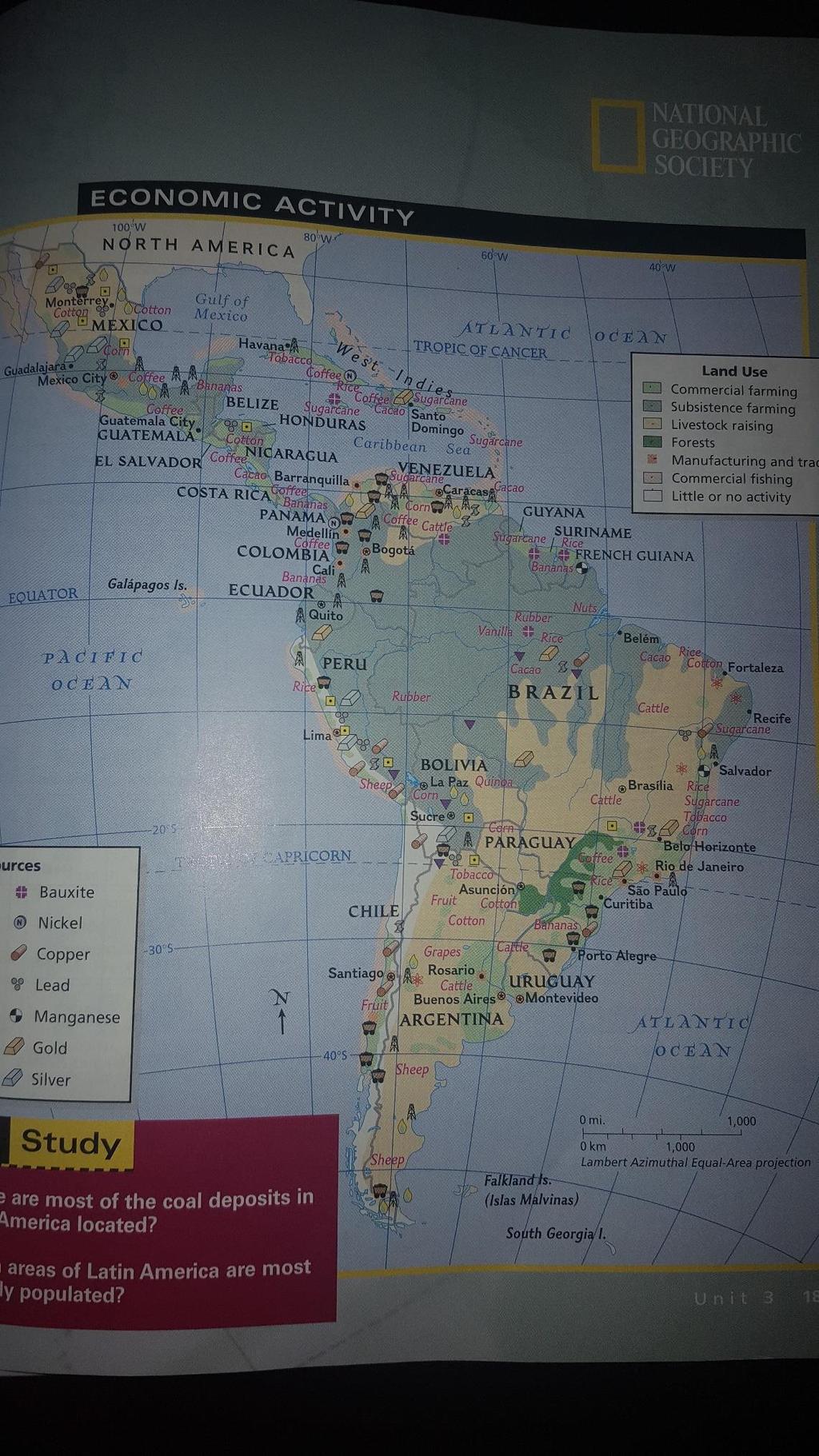
4 P a g e 3
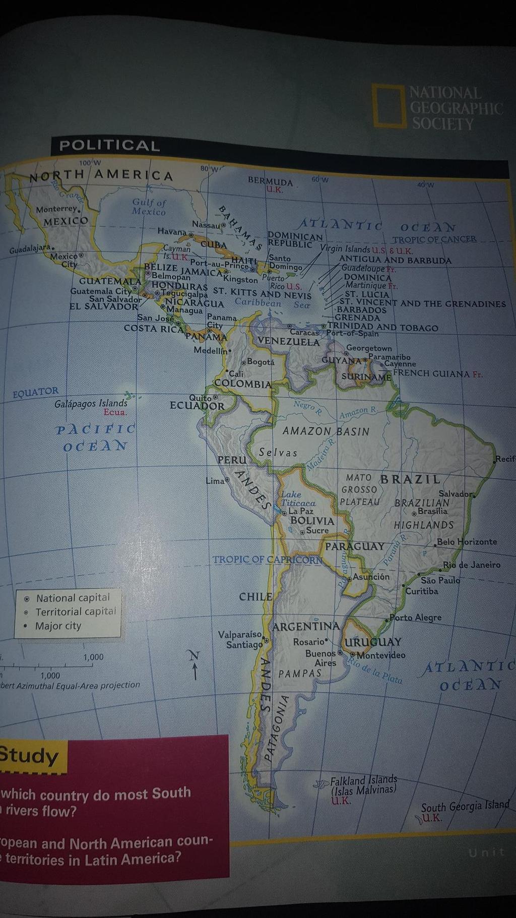
5 P a g e 4
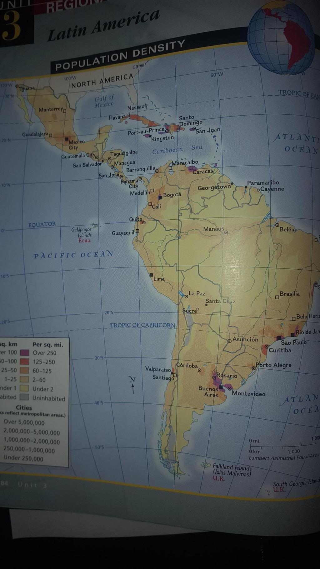
6 P a g e 5
7 P a g e 6
8 P a g e 7 Physical Notes Mountains Vertical Zonation Andes Sierra Madres Different elevations in the mountains have Different types of food can be grown at Bodies of Water Atlantic Pacific Caribbean Amazon River Orinoco River Panama Canal connects the Archipelagoes Climate Groups of islands Tropical climates cover most of the area The Greater Antilles Tropical Wet - The Lesser Antilles - Tropical Wet and Dry - Pampas Deserts
9 P a g e 8 Pampas is a grassland in Gauchos are Most of Mexico is Atacama Desert - Llanos are grasslands in Natural Hazards Part of this area is on the There are many active and Seasons The seasons are reversed When it is summer in Newport News it is in Argentina! Near the there are only wet and dry seasons Wildlife Migrations Many animals migrate to when it turns to winter in the U.S. Monarch butterflies migrate to Many birds migrate to Mexico and Central America
10 P a g e 9 Label: Llanos Pampas Andes Atacama Amazon Greater Antilles Lesser Antilles Panama Canal Low latitudes Ring of Fire Mexico Brazil Argentina
11 P a g e 10 Name Period Date Latin America Cultural Geography 1. Three important native civilizations that began in Latin America were: A. B. C. 2. The Maya lived in Their civilization was at its peak around AD. The Maya had city states ruled by kings and priests. They worshipped the gods by ritual sacrifice and blood-letting. The Maya lived in a tropical wet climate with rainforests. They practiced and grew squash and corn. 3. The Aztec lived in. Their capital was called Tenochtitlan and it was located on islands in a lake. Mexico City now stands on the ruins of the Aztec capital. The Aztec also practiced sacrifice and built large like the Maya. The Aztec empire flourished from 1400 to about 1520, when it was overthrown by the. 4. The Inca lived in. The Inca built a system of roads through the to connect their empire.
12 P a g e 11 The Inca did not have a writing system but they kept records with a complicated system of ropes with knots. 5. European Colonization Latin America was colonized by European countries. Spain colonized Portugal colonized The English colonized The French colonized 6. European Colonization The Europeans converted the natives to and made them learn their languages. The most wide spoken languages are The Europeans brought Africans to work on sugar plantations as slaves. 7. African Influences Latin America is heavily influenced by African culture. Music -
13 P a g e 12 Religion - 8. Most of Latin America has a mixed population called mestizo. Mestizos are people of mixed Spanish and Native ancestry. People in the Caribbean have mixed European, Native, and African ancestry. 9. Rigid Social Structure - Latin America has a very rigid. There are many poor people and a few rich people. The middle class is very small. During most of its history Latin America was divided among rich landlords who owned most of the land. 10. Ejidos - The ejido system refers to land. This practice was common under the Aztec rule in Mexico but disappeared under the Spanish. In the early 20th century ejidos were created again. 11. The population of Latin America is The interior of South America is difficult to settle because of the Most of the major cities are on the coast except 12. The population of Latin America is growing rapidly and people are moving into the cities in a process called. People are moving into the cities to look for jobs (push and pull factors) When poor people move into the city they create, areas of illegal housing in the city. These areas also have a high crime rate.
14 P a g e Population Many people from the Caribbean and Mexico are entering the United States in
15 P a g e 14 Agriculture Cash Crops Subsistence Farming Plantation Agriculture People build terraced fields in mountainous areas Cash Crops Disparity of Income Terraced Farming U.S. Rich LA Rich People build in mountainous areas in order to grow food. Middle Class Poor Poor Deforestation Ranching People practice in Latin America They the soil. Rainforests are being destroyed for, and. Latin America has many. Cowboys in Argentina are called. Gauchos work on the. Haciendas Minerals were large land holdings in Latin America. Some Haciendas could be, and. Haciendas were owned by and worked the land.,, and have oil. Ecuador and Venezuela are members of. Chile has large deposits of. Venezuela and Brazil have.
16 P a g e 15 NAFTA NAFTA Members are, and Pollution Mexico City has severe NAFTA is a trade agreement that abolishes between the three countries Terraced Farming Hacienda Deforestation Cash Crop Gaucho Subsistence Farming Plantation NAFTA Vocabulary
17 P a g e 16 Terms and Definitions Word Definition Easy way to remember Accounting Accountancy is the measurement, processing and communication of financial information about economic entities such as businesses and corporations Keeping a Track of the Benjamins
18 P a g e 17 Word Definition Easy way to remember Accounting Accountancy is the measurement, processing and communication of financial information about economic entities such as businesses and corporations Keeping a Track of the Benjamins


19 P a g e 18 Word Definition Easy way to remember Accounting Accountancy is the measurement, processing and communication of financial information about economic entities such as businesses and corporations Keeping a Track of the Benjamins

20 P a g e 19 Who is Eva Peron?? 1. Evita Peron? Was the second wife of the Argentine President, Juan Peron. 2. What country is she from? Argentina 3. What type of Government was it transitioning to? It was transform on democratic republic. 4. What did she do that was awesome? She became a famous actress with 15 years old, when she gets to 20 she starts her own business. Perón became a legendary figure in Argentine politics.


21 P a g e 20 My Project This was a representation of the Aztecs constant search of ways to please their Gods and the facination with the afterlife
22 P a g e 21 Test Review 1.. What cultures blended the shape of the Mexico? mayans _and_aztecs 2. Define the following? Inflation: a general increase in prices and fall in the purchasing value of money. Land Reform: Land reform, a purposive change in the way in which agricultural land is held or owned, the methods of cultivation Deforestation: the action of removing forest and it changes geography Global Warming: the climate change considered the average temperature if the world 3. What do the natives of the Caribbean Islands call themselves Taino but Columbus called them Indians 4. Mexico is known for it s exportable goods, namely chocolate and corn, which it first introduced to the world. Finally, Mexico is very famous for its food. _Also for its architecture and murals 5. Where are the Amazon rainforests located? Brazil 6. Latin America has tried to transition to a democracy. Have they been successful? Not completely because there is still countries like venezuela 7. How does the Amazon rainforest help reduce carbon dioxide and other harmful gases? The forest is full of trees and being surrounded by a area like that cleans the carbon dioxide due to the trees breathing carbon dioxide and them releasing oxygen 8. What is an Oligarchy? _ a small group of people having control of a country, organization, or institution 9. What is Biodiversity? variability of life or difference of life.
WORLD GEOGRAPHY. Hector Rodriguez
 Mr. Chavira 9th Period WORLD GEOGRAPHY Hector Rodriguez P a g e 1 Table of Contents Latin America Page 2 o Maps Economic Map Page 3 Political Map Page 4 Population Map Page 5 Physical Page 6 o Notes Physical
Mrs. Reifsnyder World Geography. Unit 8: Latin America Study Guide SOLs Addressed: WG. 1c, 2b, 3c, 4, 10b/c
 Mrs. Reifsnyder World Geography Unit 8: Latin America Study Guide SOLs Addressed: WG. 1c, 2b, 3c, 4, 10b/c Essential Questions: - In what ways do physical, economic, and cultural characteristics influence
Latin America. Physical Geography
 Latin America Physical Geography Regions Latin America can be divided into separate regions based on physical geography or cultural geography. Regions If we look at physical geography Latin America has
The Lesser Antilles. Dominican Republic), and Puerto Rico
, and Puerto Rico") The Caribbean Islands are archipelagoes or groups of islands. The major archipelagoes are: The Greater Antilles - Cuba, Jamaica, Hispaniola (Composed of Haiti and the Dominican Republic), and Puerto Rico
The Caribbean Islands are archipelagoes or groups of islands. The major archipelagoes are: The Greater Antilles - Cuba, Jamaica, Hispaniola (Composed of Haiti and the Dominican Republic), and Puerto Rico
LATIN AMERICA. Mexico Central America Caribbean Islands South America
 LATIN AMERICA Mexico Central America Caribbean Islands South America HISTORY First Settlers Hunters/gatherers from Asia crossed land bridge connecting Asia and Alaska Learned to farm over time Maize (corn)
UNIT 3 Extra Review for Chapters 9-11
 UNIT 3 Extra Review for Chapters 9-11 Mexico Central America Caribbean Islands Middle America is Central America, Mexico, and the Islands of the Caribbean Central America is a region within Middle America.
Latin America 11/4/2013. Latin America Today. 580 million people 9% of the world s population Diverse backgrounds:
 Latin America Chapter 10 Human Geography Latin America Today 580 million people 9% of the world s population Diverse backgrounds: Native Americans Europeans Africans Asians 1 Population 393 million live
Regional Atlas: Introduction to Latin America
 Chapter 9, Section World Geography Chapter 9 Regional Atlas: Introduction to Latin America Copyright 2003 by Pearson Education, Inc., publishing as Prentice Hall, Upper Saddle River, NJ. All rights reserved.
CHAPTER Latin America. Regional Atlas Study Guide. 2 Chapter A. As You Read. B. Reviewing Vocabulary
 CHAPTER 28 9 Many Th ew inventions new Regional Atlas Study Guide Latin America Directions: As you work through the Regional Atlas, complete the chart below by writing two details about each Latin American
6th Grade Western Hemisphere Geography
 6th Grade Western Hemisphere Geography Multiple Choice Identify the choice that best completes the statement or answers the question. 1 Latin America is located in the A Northern Hemisphere. C Western
CHAPTER 12. South America. Section 1: Natural Environments Section 2: History and Culture Section 3: South America Today. HOLT World Geography
 CHAPTER 12 South America Section 1: Natural Environments Section 2: History and Culture Section 3: South America 1 Section 1 Natural Environments Objectives: What are the major landforms and rivers of
Latin America. Introduction
 Latin America Introduction What are the 5 Themes of Geography? Draw lines to connect the theme to the definition: Location How humans and the environment impact each other Physical and human characteristics
6th Grade Western Hemisphere Geography
 6th Grade Western Hemisphere Geography Multiple Choice Identify the choice that best completes the statement or answers the question. 1 Latin America is located in the A Northern Hemisphere. C Western
Many ecotourists visit the various natural habitats in Central America. Why do you think ecotourism has become so popular?
 Chapter 9 Middle America and Spanish Speaking South America pg. 252 287 9 1 Central America pg. 255 259 Connecting to Your World What is one country in Central America that promotes ecotourism? Many ecotourists
Warm-up. A. Exports only manufactured goods B. Should import fewer products C. Needs to import more products D. Does not import or export
 Warm-up As with any small country, Cuba has fewer natural resources than countries such as Brazil. This affects their trade in that Cuba A. Exports only manufactured goods B. Should import fewer products
*Latin America spans 7,000 miles, from Mexico to Tierra Del Fuego. *3 Regions: Central America, South America, and the Caribbean.
 Physical Geography Latin America spans 7,000 miles, from Mexico to Tierra Del Fuego *3 Regions: Central America, South America, and the Caribbean. *Intro clip: http://www.youtube.com/watch?v=cffp6rza3
Latin America. Chapter 9 Physical Geography
 Latin America Chapter 9 Physical Geography Latin American Regions Middle America includes Mexico and the Central American countries The Caribbean Islands South America Mexico Landforms Sierra Madre Oriental
Mexico. Chapter 10. Chapter 10, Section
 Chapter 10, Section World Geography Chapter 10 Mexico Copyright 2003 by Pearson Education, Inc., publishing as Prentice Hall, Upper Saddle River, NJ. All rights reserved. Chapter 10, Section World Geography
Chapter 10 Study Guide SOUTH AMERICA
 Chapter 10 Study Guide SOUTH AMERICA When Spain and Portugal competed for trading lands in the New World, who came up with the line of demarcation to settle the dispute? The Caribbean Countries: Who was
Essential Questions. 1. How have historical figures and events affected South America today?
 South America Essential Questions 1. How have historical figures and events affected South America today? 2. How has location affected the development of countries in South America? 3. How has the role
Why is the US industry and agriculture prosperous? The US industry and agriculture is so prosperous because it has many different natural resources.
 Ch. 1-7 Study Guide Why is the US industry and agriculture prosperous? The US industry and agriculture is so prosperous because it has many different natural resources. What likely drew immigrants to the
Geographic Qualities of South America
 Geographic Qualities of South America 1. South America is the fourth largest continent in area. It is located in the Western Hemisphere, lying southwest of North America. Most of South America lies in
Comprehension Questions:
 Unit 3: Central & South america Comprehension Questions: 1. What is the driest desert on earth? Atacama Desert 2. What two water routes were discovered in the 1500s to get around the tip of South America?
The Northern Tropics
 The Northern Tropics The Guianas Countries Guyana, Suriname, French Guyana Culture reflects colonial history Official Languages Guyana English Suriname Dutch French Guyana - French Religions Suriname and
Latin America. Physical Geography
 + Latin America Physical Geography + I. Landforms A. Caribbean & Central America 1. Mexico is dominated by two mountain chains, collectively called the Sierra Madre. A high plateau is situated in between.
A funny sounding lake. South American Landforms, Climate, and Vegetation
 A funny sounding lake South American Landforms, Climate, and Vegetation 3 4 Essential Question: How have physical features and climate affected the population distribution of Latin America? 5 I. Landforms
Objective. Students will familiarize themselves with the physical features and climates of Latin America.
 Journal Write KWL What do you KNOW about Latin America? What do you WANT TO KNOW about Latin America? What did you LEARN today that you didn t know before? Latin America Objective Students will familiarize
Latin America s Physical Geography. EQ: What are characteristics of Latin America s physical features?
 Latin America s Physical Geography EQ: What are characteristics of Latin America s physical features? Your Task: We are going to participate in a Museum Walk! You will travel around the room with a partner
Human Geo of Latin America
 Human Geo of Latin America Fill in the 8 Blanks Latin America is generally understood to consist of the entire continent of South America in addition to,, Mexico Central America and the islands of the
Unit 5: Latin America Today
 Unit 5: Latin America Today In this unit, you will turn your attention to Latin America. You will study the geography of some Latin American countries. You will learn about their history, politics, revolutions,
Part 1: Physical Geography
 Part 1: Physical Geography Highlands Lowlands Wide range in elevation creates diverse climate zones in the region A mountain chain stretches along the western edge of the American continents for more
6th Grade Third Nine Weeks Benchmark Assessment
 6th Grade Third Nine Weeks Benchmark Assessment Multiple Choice Identify the choice that best completes the statement or answers the question. Key Concepts 1 Latin America is located in the A Northern
Chapter 10 Section 1. Mexico
 Chapter 10 Section 1 Mexico Spanish Conquest 1519 Hernando Cortés arrives; marched to the Aztec city, Tenochtitlan Mexico City Native way of life destroyed; 1521 the Aztecs are conquered Mexico becomes
Geography of CA and CI
 Geography of CA and CI Caribbean Islands Central America -Central America (CA) is an isthmus connecting North America to South America. It consists of 7 countries. -The Pacific side of CA is covered by
STUDY GUIDE. The Land. Physical Features of Latin America. Chapter 8, Section 1. Terms to Know DRAWING FROM EXPERIENCE ORGANIZING YOUR THOUGHTS
 For use with textbook pages 193 198. The Land Terms to Know cordillera A mountain range that runs parallel to another mountain range (page 194) altiplano A high plain (page 194) escarpment A steep cliff
Central America and the Caribbean. The Link Between North and South America
 Central America and the Caribbean The Link Between North and South America Today, the combined population of Central American countries is over 40 million larger than all of Canada. Combined, the 7 nations
Good Morning! Pick up the country profile from the front table. Sit down QUIETLY. If I gave you a new seat
 Good Morning! Pick up the country profile from the front table. Sit down QUIETLY If I gave you a new seat Atlas Work 1. Which countries border Mexico? 2. What three bodies of water border Central and South
Name: Hour: Day: The Land and Its Regions (pg ) Define, in your own words, escarpment. Define, in your own words, sertão
 Define, in your own words, escarpment. Define, in your own words, sertão") Name: Hour: Day: World Geography Guided Reading Notes Chap 12 & 13 --- ANSWER IN COMPLETE SENTENCES!!!! READ EACH QUESTION CAREFULLY & ANSWER COMPLETELY!!!! Objectives: Upon completion of reading you should
Name: Hour: Day: World Geography Guided Reading Notes Chap 12 & 13 --- ANSWER IN COMPLETE SENTENCES!!!! READ EACH QUESTION CAREFULLY & ANSWER COMPLETELY!!!! Objectives: Upon completion of reading you should
Central America and the Caribbean. The Link Between North and South America
 Central America and the Caribbean The Link Between North and South America Today, the combined population of Central American countries is over 40 million larger than all of Canada. Combined, the 7 nations
South America. pg. 520 (5 th) pg. 523 (6 th )
 pg. 523 (6 th )") South America pg. 520 (5 th) pg. 523 (6 th ) Venezuela Rich in Oil Lake Maracaibo Called Little Venice pg. 572 (5 th) pg. 574 (6 th ) Caracas 8 miles Inland 3000 pg. 572 (5 th) pg. 574 (6 th ) Caracas
South America pg. 520 (5 th) pg. 523 (6 th ) Venezuela Rich in Oil Lake Maracaibo Called Little Venice pg. 572 (5 th) pg. 574 (6 th ) Caracas 8 miles Inland 3000 pg. 572 (5 th) pg. 574 (6 th ) Caracas
Mrs. Davis s Adventures
 Mrs. Davis s Adventures Latin America Countries & Political Map NAME: DATE: PERIOD: DIRECTIONS: Use your mapping skills and textbook pages: 127, 97, and 3 to complete Mrs. Davis s Story. Transfer the countries
2018 Spring Semester Final : STUDY GUIDE
 Name: Hr: 2018 Spring Semester Final : STUDY GUIDE My final is on:, May My final will have questions and will be COLONIZATION OF NORTH & SOUTH AMERICA - Match the regions with the European countries that
Chapter 19 Test on South America
 Name Part 1 - Labeling (27 pts.) Chapter 19 Test on South America Score A. Locate the countries and territory contained in the word box below on the map of South America on the next page. Write the name
Exploring South America Learning Lapbook with Study Guide
 A J T L Grades 1-4 Exploring South America Learning Lapbook with Study Guide A Journey Through Learning www.ajourneythroughlearning.com Copyright 2013 A Journey Through Learning 1 Authors-Paula Winget
LOCATION, LOCATION, LOCATION! Mexico, Venezuela, Cuba, and Brazil
 LOCATION, LOCATION, LOCATION! Mexico, Venezuela, Cuba, and Brazil GPS and E.Q. GPS: SS6G3 The student will explain the impact of location, climate, distribution of natural resources, and population distribution
LATIN AMERICAN INDEPENDENCE MOVEMENTS : An Age of Revolutions
 LATIN AMERICAN INDEPENDENCE MOVEMENTS 1750-1914: An Age of Revolutions BACKGROUND Indigenous peoples and civilizations Maya, Aztec, Inca European Colonization, 1500s Spain, Portugal, France American Revolution,
Exploring Mexico. Directions: Complete the paragraphs below. Write the correct word from the Word Bank to complete each sentence.
 Exploring Mexico Section 1 10 Directions: Complete the paragraphs below. Write the correct word from the Word Bank to complete each sentence. Word Bank United States Central Plateau irrigation isthmus
South America. Land of Color and Contrast
 South America Land of Color and Contrast Home to: *The world s largest river system *The longest mountain chain, and second tallest mountains *Earth s driest desert *One of the world s great grassland
LOCATION, CLIMATE, AND NATURAL RESOURCES OF MEXICO
 SS6G3 The student will explain the impact of location, climate, distribution of natural resources, and population distribution on Latin America and the Caribbean. a. Compare how the location, climate,
Social Studies: The World
 Social Studies: The World What is the name of the continent that is labeled #1 on the map? North America What is the name of the continent that is labeled #2 on the map? South America What is the name
There are two countries in the Iberian Peninsula: Spain and Portugal. The name of the peninsula comes from the first inhabitants, the Iberians.
 Spain There are two countries in the Iberian Peninsula: Spain and Portugal. The name of the peninsula comes from the first inhabitants, the Iberians. After them, the peninsula was invaded by the Celts,
Brazil. Population & Culture
 Brazil Population & Culture Population of Brazil Largest country in South America 200 million people (2012 est) Growing population - approximately 1% per year Life expectancy - approx 72 years Population
LATIN AMERICA. Mexico, Central America and South America
 LATIN AMERICA Mexico, Central America and South America Physical Geography: Plate tectonics pushing together formed what major mountain range?? Andes Mountains Natural disasters the area is prone to:
Brain Wrinkles. Location, Climate, & Natural Resources of. Where People Live & How They Trade
 Location, Climate, & Natural Resources of Where People Live & How They Trade It s south of the US, east of the Pacific Ocean, and west of the Gulf of Mexico & Caribbean Sea. It s great that it s located
Latin America and The Caribbean. A Closer Look.
 Latin America and The Caribbean A Closer Look. Mexico Capital: Mexico City The Location of Mexico Mexico is the second-largest country by size and population in Latin America.but the Largest Spanish -
STANDARDS: Brain Wrinkles
 STANDARDS: SS6G3 The student will explain the impact of location, climate, distribution of natural resources, and population distribution on Latin America and the Caribbean. a. Compare how the location,
April 02, Inca. The Inca controlled a vast empire covering parts of modern day Peru, Ecudor, Bolivia, Chile, and Argentina.
 Inca The Inca controlled a vast empire covering parts of modern day Peru, Ecudor, Bolivia, Chile, and Argentina. Find the Incan Empire on your map and color it in. April 02, 2014 Cuzco was the capital
Latin American Revolutions of the early 1800s
 Latin American Revolutions of the early 1800s I. Background The Spanish/Portuguese Colonial System A. The Roles of Colonies fulfillment of mercantilism for Spain and Portugal 1. Plantation Agriculture
Sub - Saharan Africa
 Sub - Saharan Africa 4/14/2015 Countries with Relative Importance GDP South Africa Gabon Botswana Land Size Sudan Chad Mozambique Madagascar Democratic Republic of the Congo (formerly Zaire) Population
Hieroglyphics - A form of writing in which pictures are used to represent words and phrases
 Inca Civilization: 1200 AD 1535 AD -South America along Pacific Ocean. -Built vast network of roads and bridges. -Government run by emperor. -Built terraces on hills for farming. Macchu Picchu: Inca Palace.
U N I T 3 Latin America
 UN I T 3 Latin America Introducing the Region: Physical and Human Geography Chapter 9 Spatial Inequality in Mexico City: From Cardboard to Castles TCI5 428 GA_SE_ML_03-1.eps Cyan Magenta Yellow Black Second
Geography: Latin America (ch. 8, 9 and 10) page 1. p. 178: What areas make up Latin America? Mexico, Central Amer., Caribbean Islands, South America
 page 1. p. 178: What areas make up Latin America? Mexico, Central Amer., Caribbean Islands, South America") Geography: Latin America (ch. 8, 9 and 10) page 1 p. 178: What areas make up Latin America? Mexico, Central Amer., Caribbean Islands, South America Chapter 8: Physical Geography of Latin America I. The
Geography: Latin America (ch. 8, 9 and 10) page 1 p. 178: What areas make up Latin America? Mexico, Central Amer., Caribbean Islands, South America Chapter 8: Physical Geography of Latin America I. The
Introduction to Africa
 Introduction to Africa Did you know? Africa has more countries than any other continent. The Sahara is a desert that is the size of the U.S. It s the world's largest desert. Most of the world s gold and
COUNTRY DATA: Costa Rica : Information from the CIA World Factbook! INTRODUCTION GEOGRAPHY
 ! COUNTRY DATA: Costa Rica : Information from the CIA World Factbook! INTRODUCTION GEOGRAPHY Location Area Central America, bordering both the Caribbean Sea and the North Pacific Ocean, between Nicaragua
Ancient Civilizations of the Western Hemisphere. Maya, Aztec, & Inca
 Ancient Civilizations of the Western Hemisphere Maya, Aztec, & Inca THE MAYA The maximum extent of the Maya Maya - Location southern Mexico into northern Central America called the Yucatan Peninsula Maya
Content Statement: Explain how Enlightenment ideals influenced the French Revolution and Latin American wars for independence.
 Reforms, Revolutions, and Chapter War 9.3 Section 3 Independence in Latin America Content Statement: Explain how Enlightenment ideals influenced the French Revolution and Latin American wars for independence.
Countries Of The World: Mexico
 Countries Of The World: Mexico By National Geographic Kids, adapted by Newsela staff on 06.07.18 Word Count 659 Level MAX Image 1: The pyramids of Guachimontones in Jalisco, Mexico. Mexico is a country
3 rd Term Worksheet [ ] Subject Geography Class VI Name : Sec. :
![3 rd Term Worksheet [ ] Subject Geography Class VI Name : Sec. :](/thumbs/84/89736232.jpg "3 rd Term Worksheet [ ] Subject Geography Class VI Name : Sec. :") 1 geo (vi) 3 rd Term Worksheet [2018 19] Subject Geography Class VI Name : Sec. : Case Study 1 : The Lumberjacks of Canada Exercise: [80-81] [A] Choose the correct answers: [80] 1. What are the men who
1 geo (vi) 3 rd Term Worksheet [2018 19] Subject Geography Class VI Name : Sec. : Case Study 1 : The Lumberjacks of Canada Exercise: [80-81] [A] Choose the correct answers: [80] 1. What are the men who
Unit 5/Chapter 8 ticket Central America and the Caribbean
 Unit 5/Chapter 8 ticket Central America and the Caribbean Important Vocabulary Latifundia inifundia ISTHMUS : a strip of land two large strips of land ARCHIPELAGO : a or of islands BIODIVERSITY : an as
World Geography Ch. 7.2 Climate Regions of Latin America
 World Geography Ch. 7.2 Climate Regions of Latin America BR: D10 When you think of Latin America, what types of climates do you think are down there? Write down which of the following you believe are there:
early human history and Central & South America Jeopardy
 early human history and Central & South America Jeopardy Every team will be chosen by Joe with the intention of mixing girls and boys and grade levels. Teams can choose a name if desired. teams can answer
Chapter 7 Mexico, Central America, & the Caribbean
 Chapter 7 Mexico, Central America, & the Caribbean Chapter 7, Lesson 1 Physical Geography of Mexico, Central America, & the Caribbean Physical Characteristics of Mexico and Central America An isthmus narrow
Countries Of The World: Mexico
 Countries Of The World: Mexico By National Geographic Kids, adapted by Newsela staff on 06.07.18 Word Count 638 Level 800L Image 1: The pyramids of Guachimontones in Jalisco, Mexico. Mexico is a country
Friday, November 10, 2017
 Friday, November 10, 2017 Andes and Midlatitude Countries Objective: Summarize the main physical features and regions of the Southern Cone. Identify and locate the urban centers and understand the pattern
2. The most important crop in Mexico. 3. The Priest who spoke against Spain. 5. Ancient Aztec city, now Mexico City
 Name: Date: Did you hear about what happened at the laundromat last night? Three clothespins held up two shirts! Clues are listed below. Print the word that matches the clue on the blank line by the clue.
Friday, November 10, 2017
 Friday, November 10, 2017 Human Geography of the Andes and Midlatitude Countries Language Objective: Analyze the demographic information from the Andean region of South America. Finish Geography Now activity
THE ANDEAN AREA....How does the rich countries development affect some poor and 1. distant countries
 THE ANDEAN AREA...How does the rich countries development affect some poor and 1 distant countries 1. Geographical situation of the Andean area South America view 2 Andes mountain range Amazonian basin
World of the Incas and the North American Indians. Willow LeTard and Kevin Nguyen
 World of the Incas and the North American Indians Willow LeTard and Kevin Nguyen World of the Twantinsuyu 1300 c.e. in the Andean highlands Notable advances in metallurgy and architecture The Incas had
GEOGRAPHY OF THE WESTERN HEMISPHERE
 GEOGRAPHY OF THE WESTERN HEMISPHERE LEARNING LOG Write clear directions that describe how to get from one place to another. Choose 2 locations that other people might not know about. Did you use a map
Your web browser (Safari 7) is out of date. For more security, comfort and the best experience on this site: Update your browser Ignore
 is out of date. For more security, comfort and the best experience on this site: Update your browser Ignore") Your web browser (Safari 7) is out of date. For more security, comfort and the best experience on this site: Update your browser Ignore SO U TH AMERICA: HU MAN GEO GRAPHY Culture and Politics For the complete
Your web browser (Safari 7) is out of date. For more security, comfort and the best experience on this site: Update your browser Ignore SO U TH AMERICA: HU MAN GEO GRAPHY Culture and Politics For the complete
NEW SPAIN - MEXICO ( )
") NEW SPAIN - MEXICO (1521-1848) The Other Conquest In 1521, the Aztec civilization is conquered by the Spanish and over 75,000 allies. The Spanish call the new land, NUEVA ESPANA The Conquest is devastating:
NEW SPAIN - MEXICO (1521-1848) The Other Conquest In 1521, the Aztec civilization is conquered by the Spanish and over 75,000 allies. The Spanish call the new land, NUEVA ESPANA The Conquest is devastating:
1. Summarize the main physical features and regions of the Southern Cone.
 6.4 The Southern Cone L E A R N I N G O B J E C T I V E S 1. Summarize the main physical features and regions of the Southern Cone. 2. Identify and locate the urban centers and understand the pattern of
THE PRE-COLUMBIAN CIVILIZATIONS MAYA AZTEC INCA
 THE PRE-COLUMBIAN CIVILIZATIONS MAYA AZTEC INCA THE MAYAN CIVILIZATION Where were the Maya located? The Maya were located mainly in the Yucatan Peninsula, and stretched to Belize & Guatemala The civilization
COUNTRY DATA: Haiti : Information from the CIA World Factbook INTRODUCTION
 COUNTRY DATA: Haiti : Information from the CIA World Factbook INTRODUCTION The native Taino Amerindians - who inhabited the island of Hispaniola when it was discovered by COLUMBUS in 1492 - were virtually
Nicaragua versus Costa Rica?
 Nicaragua versus Costa Rica? Overview: Today I want to look at Nicaragua versus Costa Rica from both a destination for retiree s standpoint and for potential investment interest. First I'll provide some
Wars of Independence in the Caribbean and Latin America
 Wars of Independence in the Caribbean and Latin America Colonial Latin America: Politics and Economy -Spain and Portugal: kings rule as absolute monarchs -In Spanish colonies in the New World, the Viceroy
Warm ups *What was the most valuable natural resource in the development of the Northeast? Why? *What does a megalopolis refer to?
 Warm ups 9.22.2016 *What was the most valuable natural resource in the development of the Northeast? Why? *What does a megalopolis refer to? Lesson Objective: *identify the key natural resources that influenced
Chapter 5 Middle America
 Chapter 5 Middle America Identifying the Boundaries Middle America, the geographic realm between the United States and the continent of South America, consists of three main regions: the Caribbean, Mexico,
Portuguese Language - Fostering National Unity
 Geography Brazil Brazil Portuguese Language - Fostering National Unity 11 dialects of Portuguese Influenced by Amerindian and African languages, creating differences between Portuguese spoken in Brazil
FROM COLONY TO INDPENDENT NATION
 FROM COLONY TO INDPENDENT NATION Quiz: Wednesday! Aztecs, Incas, Cuban Revolution, Zapatista Movement, Independence Movements! HW: finish notes and complete Multi-Level Review Tomorrow: We begin Government
Maya, Aztec, and Inca Civilizations
 Maya, Aztec, and Inca Civilizations Mesoamerica Mesoamerica = Mexico & Central America Mesoamerica Some of the greatest civilizations in the Americas developed in Mesoamerica The Maya and Aztec lived in
COUNTRY DATA: Cuba : Information from the CIA World Factbook
 COUNTRY DATA: Cuba : Information from the CIA World Factbook INTRODUCTION The native Amerindian population of Cuba began to decline after the European discovery of the island by Christopher COLUMBUS in
South & Central America, including Mexico Information
 South & Central America, including Mexico Information From the Amazon to the Andes and all of the mystical wonders in between, Mexico and South and Central America are full of stories to tell. Whether
Argentina. Argentina A Reading A Z Level S Leveled Book Word Count: 1,048 LEVELED BOOK S
 Argentina A Reading A Z Level S Leveled Book Word Count: 1,048 LEVELED BOOK S Connections Writing Make a travel diary describing a pretend trip to Argentina. Include interesting details and fun facts about
The Aztecs and the Mayans were advanced in mathematics (in fact their calendar was more accurate than the European one at the time ) Mexico has a
 Mexico has a") México Notes on Mexico Two of the most influential cultures in Mexico were the Aztecs and Mayans. The capital of Mexico before Christopher Columbus arrived in America was Tenochtitlán. It was the capital
México Notes on Mexico Two of the most influential cultures in Mexico were the Aztecs and Mayans. The capital of Mexico before Christopher Columbus arrived in America was Tenochtitlán. It was the capital
Southern Africa. Countries, Geography, & Climate
 Countries, Geography, & Climate The Southern African region consists of the following countries: Angola Zambia Malawi Mozambique Zimbabwe Botswana Namibia Swaziland Lesotho South Africa Comoros Madagascar
Chapter 21: EAST AFRICA
 Chapter 21: EAST AFRICA Physical Geography of East Africa Landforms East Africa is a diverse landscape of different plains, volcanic mountains, and plateaus cut by a large valley and marked by many rivers
THE PRE-COLUMBIAN CIVILIZATIONS MAYA AZTEC INCA
 THE PRE-COLUMBIAN CIVILIZATIONS MAYA AZTEC INCA THE MAYAN CIVILIZATION Where were the Maya located? The Maya were located mainly in the Yucatan Peninsula, and stretched to Belize & Guatemala The civilization
South American Countries. Capital Location Population Terrain Climate
 South American Countries Capital Location Population Terrain Climate Andes Mountains Four large areas that make up the Central Plains: Llanos, the Selva, the Gran Chaco, and the Pampas Brazilian Highlands
ANDEX: A Regional Hydrology Program for the Andes
 ANDEX: A Regional Hydrology Program for the Andes Silvina Solman CIMA (CONICET-UBA) - Universidad de Buenos Aires Argentina Germán Poveda Universidad Nacional de Colombia, Medellín Colombia TPE-GHP/GEWEX