Chapter 21: EAST AFRICA
|
|
|
- Theodore Farmer
- 6 years ago
- Views:
Transcription

1 Chapter 21: EAST AFRICA
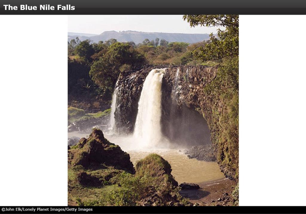
2 Physical Geography of East Africa Landforms East Africa is a diverse landscape of different plains, volcanic mountains, and plateaus cut by a large valley and marked by many rivers and lakes. The Great Rift Valley cuts through much of East Africa forming two branches, both of which lie within a set of fault lines. Transportation via water is of great economic importance to the area, such as Eritrea s access to the Red Sea and Kenya and Tanzania s access to the Indian Ocean.

3 The Great Rift Valley
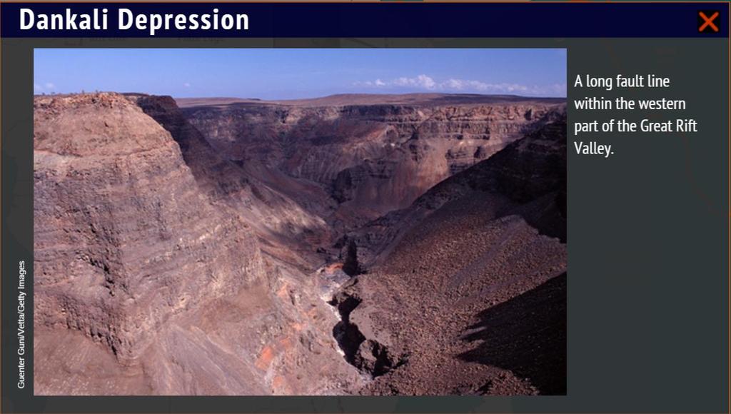
4
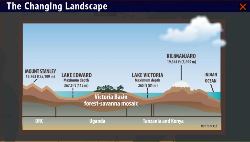
5
6 Physical Geography of East Africa Water Systems East Africa s many lakes and rivers are used for hydroelectric power, fishing, and transportation and support tourism, agriculture, and natural ecosystems. Lake Victoria, one of the largest freshwater lakes in the world, lies at the headwaters of the White Nile River and is surrounded by rich soil that has encouraged human settlement. Lake Tanganyika, one of the deepest freshwater lakes in the world, offers abundant fishing and also supports large populations.

7 Lake Victoria

8 Lake Victoria
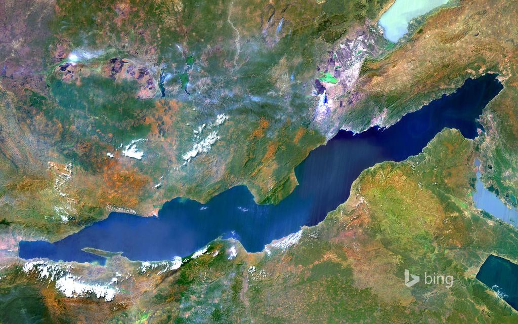
9 Lake Tanganyika
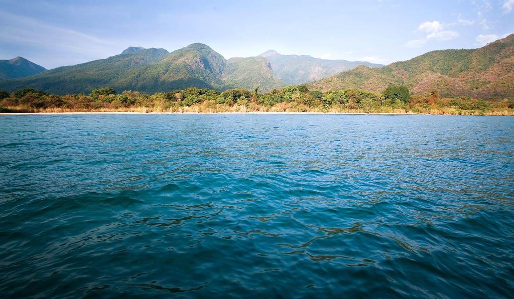
10 Lake Tanganyika
11
12 Physical Geography of East Africa Climates, Biomes, & Resources Covering a wide range of latitudes and elevations, East Africa consists of a diverse set of climates and biomes. The savanna, a tropical grassland with scattered trees, has alternating wet and dry seasons, with the Serengeti Plain making a home for millions of animals. Mining and agriculture contribute to the area s economy.
13

14
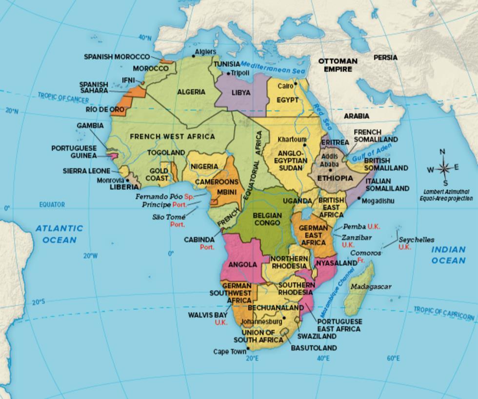
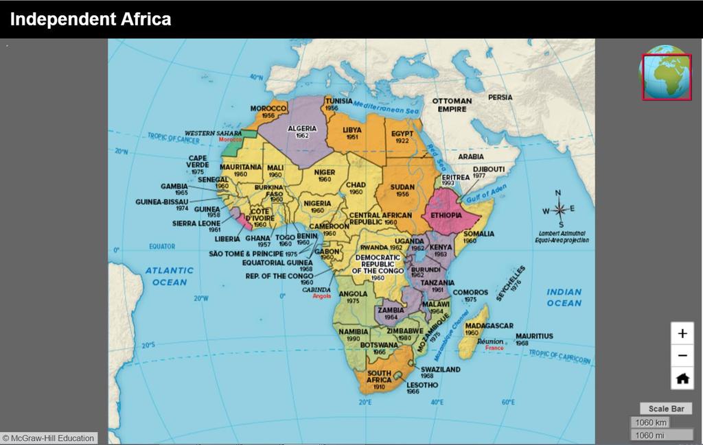
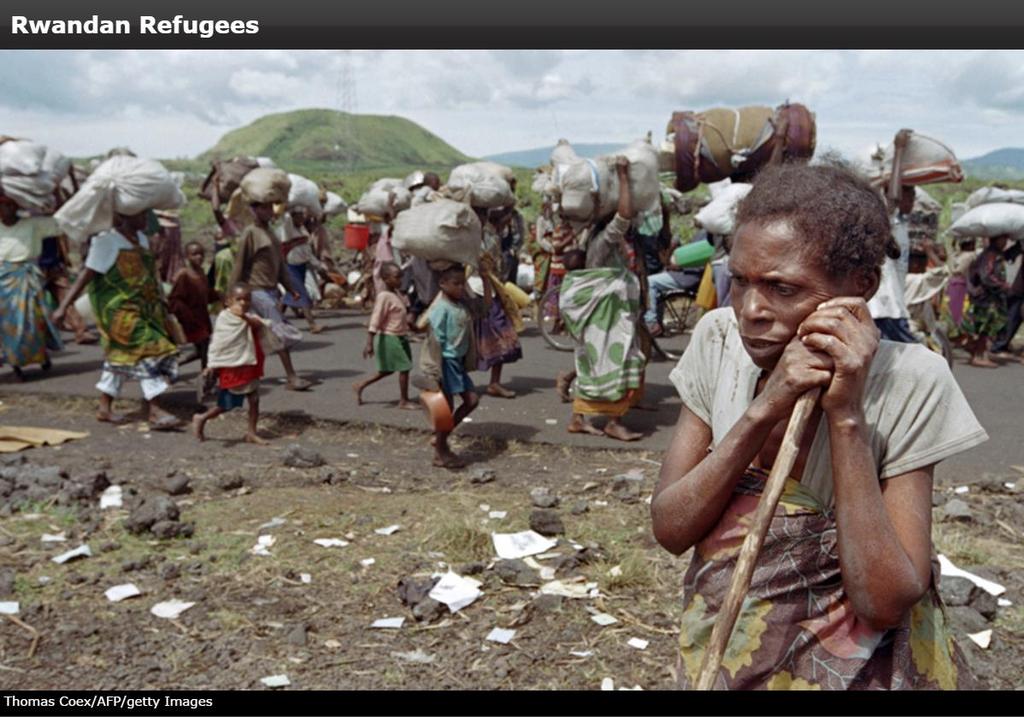
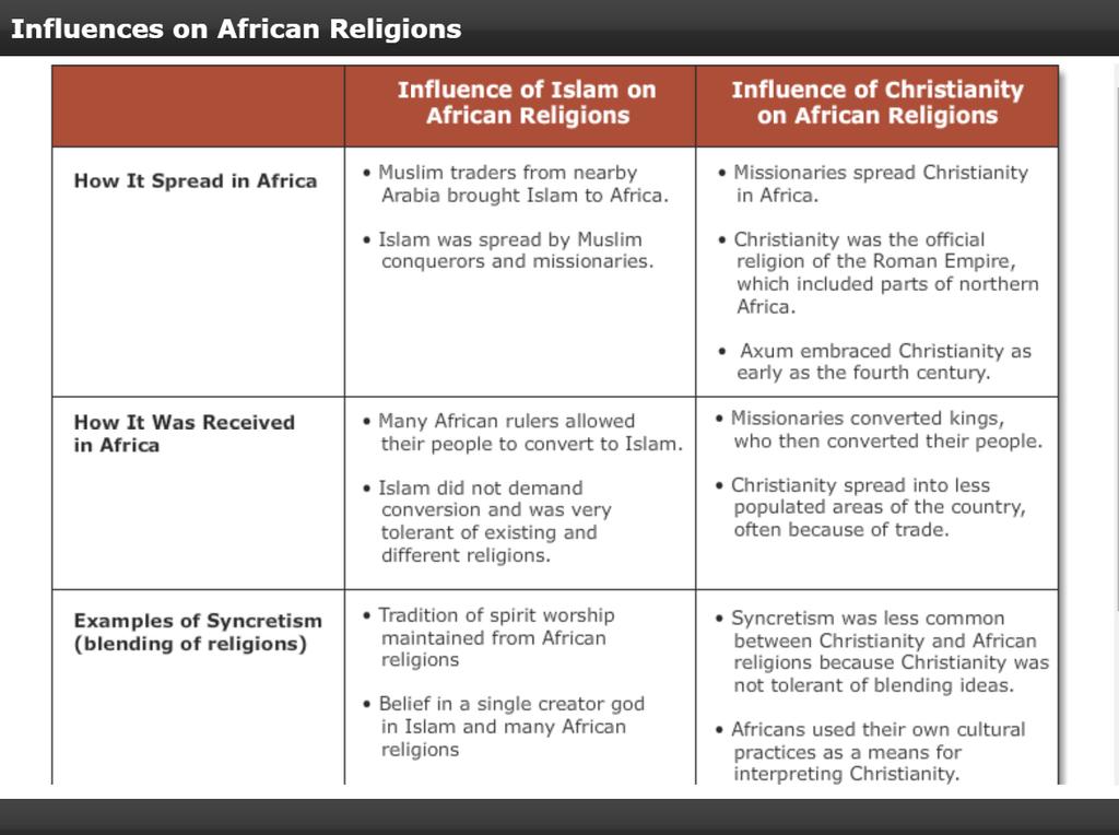
15 Human Geography of East Africa History & Government With access from the Red Sea and Indian Ocean, traders established colonies in East Africa. Colonial European powers, looking to expand trade routes and capitalize on new opportunities, created enormous problems for Africa. Although many countries gained independence in the 1960s, long-standing challenges persisted. Conflict between indigenous, or native, peoples resulted in extraordinary dislocations.
16
17
18
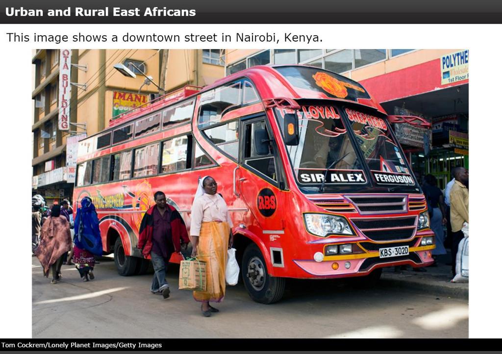
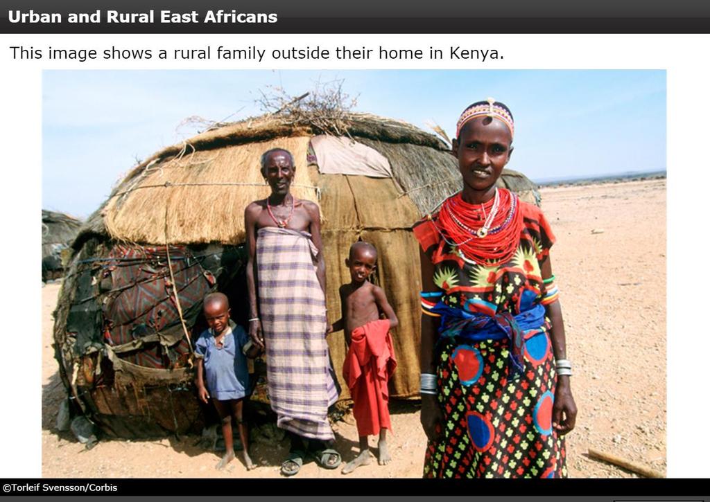
19 Human Geography of East Africa Population Patterns Today s population reflects the many languages, belief systems, and ways of life in the subregion. In many countries, one ethnic group is the majority of the population. Most cities are located on coasts or rivers, although some inland cities developed along trade routes; however, in general, rates of urbanization are low. Population densities are high on fertile lands near water where better irrigation of crops is possible.
20
21
22 Human Geography of East Africa Society & Culture Today Most people in the subregion are either Christian or Muslim, but traditional animist religions are also practiced. Levels of education vary, with literacy rates higher among men than women, and many students leave school so they can work and contribute to family income. Poor nutrition, famine, overpopulation, and the inability to treat common diseases, such as AIDS, are chronic issues in East Africa.
23
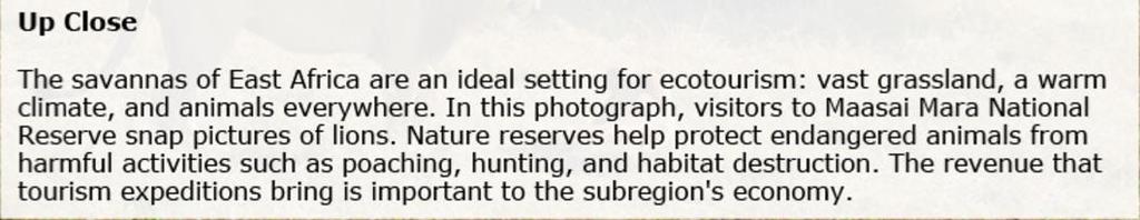
24 Human Geography of East Africa Economic Activities The majority of jobs are in agriculture, with most products earmarked as exports, commodities sent from one country to another. The focus on cash crops, such as coffee, instead of food staples has created food-supply issues. Ecotourism, highlighting the many unique attributes of the subregion, has become a key part of the economy. China s investment and trade within the subregion has skyrocketed since 2001, encouraging positive changes.
25
26
27
28
29
30 People and Their Environment: East Africa Managing Resources The failure to face environmental challenges contributes to the continuing cycle of poverty and hunger. Conflict, governmental corruption, and mismanagement of resources compound the issues confronting the subregion. Governments and organizations in the subregion have slowly improved health care, literacy, and standards of living.
31
32
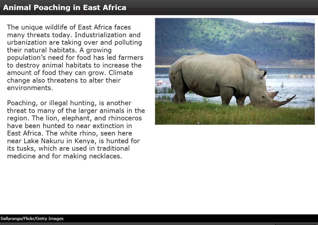
33 People and Their Environment: East Africa Human Impact The lack of infrastructure, such as electricity, encourages deforestation, as people turn to wood for cooking and heating. The destruction of animal habitats, or living areas, is exacerbated by deforestation and poaching, or illegal hunting, causing many species to become endangered. As the population increases in fertile areas around waterways, pollution threatens the area s waters and marine life.
34
35 People and Their Environment: East Africa Addressing the Issues Governments are taking steps to protect the environment, such as establishing national parks. The naming of UNESCO world heritage sites has raised awareness of conservation efforts in the subregion. Wildlife reserves have helped revive animal populations and have encouraged ecotourism, bringing millions of dollars into the subregion s economies.
36
37
38
Chapter 16 ~ Eastern Mediterranean
 Chapter 16 ~ Eastern Mediterranean Physical Geography of the Eastern Mediterranean Landforms This area is known as the Levant and includes Syria, Jordan, Lebanon, Israel, and the Palestinian territories.
Chapter 16 ~ Eastern Mediterranean
 Chapter 16 ~ Eastern Mediterranean Physical Geography of the Eastern Mediterranean Landforms This area is known as the Levant and includes Syria, Jordan, Lebanon, Israel, and the Palestinian territories.
UNIT 5 AFRICA PHYSICAL GEOGRAPHY SG 1 - PART II
 UNIT 5 AFRICA PHYSICAL GEOGRAPHY SG 1 - PART II III. CLIMATE & VEGETATION A. The four main climate zones are tropical wet, tropical wet/dry (split into monsoon & savanna), semiarid, and arid. Other climate
Just how big is Africa?
 The United States China India The United Kingdom Portugal Spain France Belgium Germany The Netherlands Switzerland Italy Eastern Europe Japan 11.7 million sq. miles Just how big is Africa? Chapter 18 Section
Physical characteristics and biomes:
 Physical characteristics and biomes: Sahel region, bordering Sahara Characteristics Area suffers from lack of rainfall, over grazing, which causes loss of vegetation and loss of inhabitable areas causing
CHAPTER 12. South America. Section 1: Natural Environments Section 2: History and Culture Section 3: South America Today. HOLT World Geography
 CHAPTER 12 South America Section 1: Natural Environments Section 2: History and Culture Section 3: South America 1 Section 1 Natural Environments Objectives: What are the major landforms and rivers of
Chapter 20. The Physical Geography of Africa South of the Sahara
 Chapter 20 The Physical Geography of Africa South of the Sahara Chapter Objectives Identify the major landforms, water systems, and natural resources of Africa south of the Sahara. Describe the relationship
Introduction to Africa
 Introduction to Africa Did you know? Africa has more countries than any other continent. The Sahara is a desert that is the size of the U.S. It s the world's largest desert. Most of the world s gold and
How to play. The center aisle divides our class into 2 teams. Team members are NOT allowed to help their teammate when they are asked a question.
 Floaters & Sinkers How to play The center aisle divides our class into 2 teams. Each person will be responsible for answering a question for every round played. Team members are NOT allowed to help their
The Northern Tropics
 The Northern Tropics The Guianas Countries Guyana, Suriname, French Guyana Culture reflects colonial history Official Languages Guyana English Suriname Dutch French Guyana - French Religions Suriname and
Chapter 24: Southern Africa. Unit 6
 Chapter 24: Southern Africa Unit 6 Section 1: Physical Geography Landforms Region is made up of 14 countries: 1. Angola 2. Zambia 3. Malawi 4. Mozambique 5. Namibia 6. Botswana 7. Zimbabwe 8. South Africa
AFRICAN PHYSICAL GEOGRAPHY
 AFRICAN PHYSICAL GEOGRAPHY Here are some factoids about Africa: world s second largest continent (11,700,000 miles). Home to 52 countries, 1,000 languages, 800 million people. 10% of the world s population
Sub - Saharan Africa
 Sub - Saharan Africa 4/14/2015 Countries with Relative Importance GDP South Africa Gabon Botswana Land Size Sudan Chad Mozambique Madagascar Democratic Republic of the Congo (formerly Zaire) Population
ALBERTA S GRASSLANDS IN CONTEXT
 ALBERTA S GRASSLANDS IN CONTEXT GLOBAL GRASSLANDS 1 Temperate grasslands, located north of the Tropic of Cancer and south of the Tropic of Capricorn, are one of the world s great terrestrial biomes 2.
Southern Africa. Countries, Geography, & Climate
 Countries, Geography, & Climate The Southern African region consists of the following countries: Angola Zambia Malawi Mozambique Zimbabwe Botswana Namibia Swaziland Lesotho South Africa Comoros Madagascar
Brazil. Chapter 12. Chapter 12, Section
 Chapter 12, Section World Geography Chapter 12 Brazil Copyright 2003 by Pearson Education, Inc., publishing as Prentice Hall, Upper Saddle River, NJ. All rights reserved. Chapter 12, Section World Geography
Brain Wrinkles. Africa: The impact of location, climate, & physical characteristics on where people live, the type of work they do, & how they travel
 Africa: The impact of location, climate, & physical characteristics on where people live, the type of work they do, & how they travel STANDARDS: SS7G3 The student will explain the impact of location, climate,
SS7G1 The student will locate selected features of Africa.
 Standards SS7G1 The student will locate selected features of Africa. a. Locate on a world and regional political-physical map: the Sahara, Sahel, savanna, tropical rain forest, Congo River, Niger River,
Chapter 24: Southern Africa. Unit 6
 Chapter 24: Southern Africa Unit 6 Section 1: Physical Geography Landforms Region is made up of 14 countries: 1. 2. Zambia 3. 4. Mozambique 5. 6. Botswana 7. 8. South Africa 9. 10. Swaziland 11. 12. Madagascar
pg. 446 (5 th) pg. 456 (6 th )
 pg. 456 (6 th )") pg. 446 (5 th) pg. 456 (6 th ) African Landscape Plateau Highest in: Ethiopian Highlands Drakensberg Mtns. Lesotho & So. Africa pg. 452 (5 th) pg. 459 (6 th ) Ethiopian Highlands Canyons carved by water
pg. 446 (5 th) pg. 456 (6 th ) African Landscape Plateau Highest in: Ethiopian Highlands Drakensberg Mtns. Lesotho & So. Africa pg. 452 (5 th) pg. 459 (6 th ) Ethiopian Highlands Canyons carved by water
STUDY GUIDE. The Land. Chapter 20, Section 1. The Land of Africa South of the Sahara. Landforms Water Systems Natural Resources.
 For use with textbook pages 499 504. The Land Terms to Know escarpment A steep, often jagged slope or cliff (page 500) cataract A towering waterfall (page 500) rift valley A large crack in the earth s
Unit 6 vocabulary. Serengeti Plain
 basin Nile River rift valley Mount Kilimanjaro escarpment Sahara aquifer oasis Serengeti Plain canopy Niger delta Sahel the world s longest river, flowing more than 4,000 miles through Uganda and Sudan
Monday, December 11, 2017
 Monday, December 11, 2017 Physical Geography of Russia Objective: complete Warm-Up, write outline notes and discuss the geography of Eastern Europe/mother Russia and view Geography Now: Belarus. География
COUNTRY DATA: Costa Rica : Information from the CIA World Factbook! INTRODUCTION GEOGRAPHY
 ! COUNTRY DATA: Costa Rica : Information from the CIA World Factbook! INTRODUCTION GEOGRAPHY Location Area Central America, bordering both the Caribbean Sea and the North Pacific Ocean, between Nicaragua
One Commodity Map. 7. What is a commodity? 8. Explain what a one-commodity country is.
 7. What is a commodity? 8. Explain what a one-commodity country is. 9. What must African countries do in order to become more stable economically? One Commodity Map Countries which OIL is the lone commodity
Australian Geography. Standards:
 Australian Geography Standards: SS6G12 The student will be able to locate selected features of Australia. a. Locate on a world and regional political-physical map: the Great Barrier Reef, Coral Sea, Ayers
Chapter 13 and 14 Geography Study Guide
 Chapter 13 and 14 Geography Study Guide Multiple Choice Identify the letter of the choice that best completes the statement or answers the question. 1. Which West African country has the largest population
COUNTRY DATA: BRAZIL: Information from the CIA World Factbook INTRODUCTION
 COUNTRY DATA: BRAZIL: Information from the CIA World Factbook INTRODUCTION Following more than three centuries under Portuguese rule, Brazil gained its independence in 1822, maintaining a monarchical system
3rd International Forum on sustainable Tourism 20th to 22nd October 2008 Bamako - Mali
 TANZANIA S POLICY ON TOURISM DEVELOPMENT 3rd International Forum on sustainable Tourism 20th to 22nd October 2008 Bamako - Mali Ministry of Natural Resources and Tourism - Tanzania 1 Tanzania basic facts
The Wonderful Land of Zambia
 The Wonderful Land of Zambia Jessica Geography Have you ever wondered about Zambia's geography? If so, I'm here to tell you! Their climate is very tropical being between 50-80 every day. But it is also
Latin America. Chapter 9 Physical Geography
 Latin America Chapter 9 Physical Geography Latin American Regions Middle America includes Mexico and the Central American countries The Caribbean Islands South America Mexico Landforms Sierra Madre Oriental
Chapter 7 Geography and the Early Settlement of Egypt, Kush, and Canaan
 Chapter 7 Geography and the Early Settlement of Egypt, Kush, and Canaan How did geography affect early settlement in Egypt, Kush, and Canaan? Section 7.1 - Introduction RF/NASA//Corbis This satellite photograph
BRITANNICA STUDENT ENCYCLOPEDIA. Africa is the world s second largest continent. More than 50 countries make up
 JOBNAME: No Job Name PAGE: 33 SESS: 682 OUTPUT: Thu Aug 31 10:43:41 2006 38 Africa BRITANNICA STUDENT ENCYCLOPEDIA Africa Africa is the world s second largest continent. More than 50 countries make up
UNIT 3 Extra Review for Chapters 9-11
 UNIT 3 Extra Review for Chapters 9-11 Mexico Central America Caribbean Islands Middle America is Central America, Mexico, and the Islands of the Caribbean Central America is a region within Middle America.
Africa: Physical geography
 Africa: Physical geography By National Geographic Society, adapted by Newsela staff on 09.15.17 Word Count 1,279 Level 1040L African elephants roam the savannas, which cover almost half of the African
LOCATION, CLIMATE, AND NATURAL RESOURCES OF MEXICO
 SS6G3 The student will explain the impact of location, climate, distribution of natural resources, and population distribution on Latin America and the Caribbean. a. Compare how the location, climate,
Essential Questions. 1. How have historical figures and events affected South America today?
 South America Essential Questions 1. How have historical figures and events affected South America today? 2. How has location affected the development of countries in South America? 3. How has the role
Friday, November 10, 2017
 Friday, November 10, 2017 Andes and Midlatitude Countries Objective: Summarize the main physical features and regions of the Southern Cone. Identify and locate the urban centers and understand the pattern
UNIT 5 PHYSICAL GEOGRAPHY SG 1 - PART I
 UNIT 5 PHYSICAL GEOGRAPHY SG 1 - PART I Africa is HUGE! I. LANDFORMS A. Plateaus - an area of relatively level high ground. 1. Africa s interior is dominated by series of plateaus and elevated basins such
Chapter Objectives. Describe the dominant landforms and natural resources of Southeast Asia. Discuss Southeast Asia s climate and vegetation.
 Chapter Objectives Describe the dominant landforms and natural resources of Southeast Asia. Discuss Southeast Asia s climate and vegetation. The Land Section 1 Objectives Describe how tectonic plates and
Mrs. Reifsnyder World Geography. Unit 8: Latin America Study Guide SOLs Addressed: WG. 1c, 2b, 3c, 4, 10b/c
 Mrs. Reifsnyder World Geography Unit 8: Latin America Study Guide SOLs Addressed: WG. 1c, 2b, 3c, 4, 10b/c Essential Questions: - In what ways do physical, economic, and cultural characteristics influence
EASTERN AFROMONTANE 1,043,191 km 2
 Egypt Saudi Arabia Oman EASTERN AFROMONTANE 1,043,191 km 2 Sudan Asmara Eritrea Yemen Djibouti Addis Ababa South Sudan Ethiopia BIODIVERSITY TARGET 2020 TARGET: 17% protected Democratic Republic of the
Oceania. Australia, New Zealand, and the Pacific Islands. Physical Geography. Where is Australia located?
 Oceania Australia, New Zealand, and the Pacific Islands Physical Geography Australia New Zealand Oceania Where is Australia located? Australia & Oceania are a group of islands located between Asia, Antarctica,
Namibia, formally The Republic of Namibia, is located in the southwestern region
 Namibia Location Namibia, formally The Republic of Namibia, is located in the southwestern region of the continent of Africa. Its western boarder is Atlantic coastline. Namibia borders The Republic of
Gambia vs Ethiopia Gambia Ethiopia. Wednesday, March 21, 12
 Gambia vs Ethiopia Gambia Ethiopia Climate Change Gambia s normal climate is subtropical. Slightly dry and rainy. But recently there has been climate change and the country s capital is said to be completely
STUDY GUIDE. The Land. Chapter 29, Section 1. Both. Terms to Know DRAWING FROM EXPERIENCE ORGANIZING YOUR THOUGHTS
 Chapter 29, Section 1 For use with textbook pages 719 724. The Land Terms to Know cordilleras Parallel mountain ranges and plateaus (page 719) archipelago A group of islands (page 720) insular Relating
Challenges and opportunities in developing tourism to support the restoration of the Gorongosa National Park Mozambique By Mateus Mutemba
 Challenges and opportunities in developing tourism to support the restoration of the Gorongosa National Park Mozambique By Mateus Mutemba Gorongosa National Park 4000 km 2 at the terminus of the Great
WORLD GEOGRAPHY. Hector Rodriguez
 Mr. Chavira 9th Period WORLD GEOGRAPHY Hector Rodriguez P a g e 1 Table of Contents Latin America Page 2 o Maps Economic Map Page 3 Political Map Page 4 Population Map Page 5 Physical Page 6 o Notes Physical
Regional Atlas: Introduction to Latin America
 Chapter 9, Section World Geography Chapter 9 Regional Atlas: Introduction to Latin America Copyright 2003 by Pearson Education, Inc., publishing as Prentice Hall, Upper Saddle River, NJ. All rights reserved.
Mediterranean Europe
 Chapter 17, Section World Geography Chapter 17 Mediterranean Europe Copyright 2003 by Pearson Education, Inc., publishing as Prentice Hall, Upper Saddle River, NJ. All rights reserved. Chapter 17, Section
Chapter 17. North Africa, Southwest Asia and Central Asia
 Chapter 17 North Africa, Southwest Asia and Central Asia Chapter Objectives Describe the major landforms and natural resources of North Africa, Southwest Asia, and Central Asia. Discuss the climate and
Chapter 13 Eastern Europe & Western Russia: Recovering from war, communism, genocide, and unfortunate geography (Pg )
") Chapter 13 Eastern Europe & Western Russia: Recovering from war, communism, genocide, and unfortunate geography (Pg. 393-420) Lesson 1: Physical Geography of Eastern Europe & Western Russia Pg. 396-401
Chapter 13 Eastern Europe & Western Russia: Recovering from war, communism, genocide, and unfortunate geography (Pg. 393-420) Lesson 1: Physical Geography of Eastern Europe & Western Russia Pg. 396-401
Chapter 14. The Physical Geography of Russia
 Chapter 14 The Physical Geography of Russia Chapter Objectives Identify the physical features and natural resources of Russia. Discuss the effects of Russia s climate and vegetation on life in the region.
Chapter 7: The Geography and Settlement of Egypt, Kush, and Canaan
 Chapter 7: The Geography and Settlement of Egypt, Kush, and Canaan Learning Target: I can explain how geography affected early settlement in Egypt, Kush, and Canaan. Ancient Egypt and the Middle East Can
Chapter 7. Geography and the Early Settlement of Egypt, Kush, and Canaan
 Chapter 7 Geography and the Early Settlement of Egypt, Kush, and Canaan Chapter 7 Geography and the Early Settlement of Egypt, Kush, and Canaan How did geography affect early in Egypt Kush, and Canaan?
STUDY GUIDE. The Land. Physical Features of Latin America. Chapter 8, Section 1. Terms to Know DRAWING FROM EXPERIENCE ORGANIZING YOUR THOUGHTS
 For use with textbook pages 193 198. The Land Terms to Know cordillera A mountain range that runs parallel to another mountain range (page 194) altiplano A high plain (page 194) escarpment A steep cliff
North Africa. Chapter 25. Chapter 25, Section
 Chapter 25, Section World Geography Chapter 25 North Africa Copyright 2003 by Pearson Education, Inc., publishing as Prentice Hall, Upper Saddle River, NJ. All rights reserved. Chapter 25, Section World
North Africa and Southwest Asia. Economic Geography
 North Africa and Southwest Asia Economic Geography Natural Resources Oil is the major resource in this region. Many countries in this region are members of OPEC (Organization of Petroleum Exporting Countries).
Melanie Larsen Sinouthasy (Okombo)
") Melanie Larsen Sinouthasy (Okombo) Learning Objectives Geography Climate and Landscape History Culture Language Modern Society Health Disparities Kenyans in Minnesota Geography Geography Fast Facts Population:
Melanie Larsen Sinouthasy (Okombo) Learning Objectives Geography Climate and Landscape History Culture Language Modern Society Health Disparities Kenyans in Minnesota Geography Geography Fast Facts Population:
Unit 9 The Middle East SG 1 - Physical Geography, Population & Demographics
 Unit 9 The Middle East SG 1 - Physical Geography, Population & Demographics I. Physical Geography A. The Middle East includes southwestern Asia and North Africa. 1. The name is Eurocentric. Middle East
*Latin America spans 7,000 miles, from Mexico to Tierra Del Fuego. *3 Regions: Central America, South America, and the Caribbean.
 Physical Geography Latin America spans 7,000 miles, from Mexico to Tierra Del Fuego *3 Regions: Central America, South America, and the Caribbean. *Intro clip: http://www.youtube.com/watch?v=cffp6rza3
Mexico. Chapter 10. Chapter 10, Section
 Chapter 10, Section World Geography Chapter 10 Mexico Copyright 2003 by Pearson Education, Inc., publishing as Prentice Hall, Upper Saddle River, NJ. All rights reserved. Chapter 10, Section World Geography
Latin America and The Caribbean. A Closer Look.
 Latin America and The Caribbean A Closer Look. Mexico Capital: Mexico City The Location of Mexico Mexico is the second-largest country by size and population in Latin America.but the Largest Spanish -
HIGH-END ECOTOURISM AS A SUSTAINABLE LAND USE OPTION IN RURAL AFRICA:
 HIGH-END ECOTOURISM AS A SUSTAINABLE LAND USE OPTION IN RURAL AFRICA: THE ROLE OF EMPLOYMENT IN POVERTY REDUCTION & SOCIAL WELFARE Sue Snyman, March 2011 sues@wilderness.co.za INTRODUCTION Rural Communities
Terms to Know. artesian well coral atoll krill lagoon
 Chapter Objectives Describe the diverse landforms and natural resources of Australia, Oceania, and Antarctica. Discuss the wide range of climates and vegetation throughout the region. The Land Section
1st Period Mr. Chavira WORLD GEOGRAPHY. Hector Rodriguez
 1st Period Mr. Chavira WORLD GEOGRAPHY Hector Rodriguez P a g e 1 Table of Contents Latin America Page 2 o Maps Economic Map Page 3 Political Map Page 4 Population Map Page 5 Physical Page 6 o Notes Physical
COUNTRY DATA: Haiti : Information from the CIA World Factbook INTRODUCTION
 COUNTRY DATA: Haiti : Information from the CIA World Factbook INTRODUCTION The native Taino Amerindians - who inhabited the island of Hispaniola when it was discovered by COLUMBUS in 1492 - were virtually
Africa s. Presentation, Graphic Organizers, & Activities
 Africa s Presentation, Graphic Organizers, & Activities STANDARDS: SS7G1 Locate selected features of Africa. a. Locate on a world and regional political-physical map: Sahara, Sahel, savanna, tropical rain
Saadani National Park, Tanzania: Fostering Long Term Sustainability of Community Based Conservation and Development
 Saadani National Park, Tanzania: Fostering Long Term Sustainability of Community Based Conservation and Development Bruce Downie Kesho Trust, Tanzania; bdownie@thekeshotrust.org Key Messages Activities
Biodiversity is life Biodiversity is our life
 Biodiversity is life Biodiversity is our life Chapter 10 Section 2 Biodiversity at Risk Objectives Define and give examples of endangered and threatened species. Describe several ways that species are
6th Grade Western Hemisphere Geography
 6th Grade Western Hemisphere Geography Multiple Choice Identify the choice that best completes the statement or answers the question. 1 Latin America is located in the A Northern Hemisphere. C Western
Ancient Egypt and the Near East
 *O*»f ' i ft Ancient Egypt and the Near East Chapter 7 Chapter 8 Chapter 9 Geography and the Early Settlement of Egypt, Kush, and Canaan The Ancient Egyptian P h a r a o h s Daily Life in Ancient Egypt
Rivers. Highlights of some of the World s Most Famous Rivers!
 Rivers Highlights of some of the World s Most Famous Rivers! Directions This Power Point presentation contains information about some of the most famous rivers in the world! Students should use this presentation
MT - GEOGRAPHY - (73) - SEMI PRELIM - I : PAPER - 6
 - SEMI PRELIM - I : PAPER - 6") 08 00 MT MT - GEOGRAPHY - (73) - SEMI PRELIM - I : PAPER - 6 Time : Hours (Model Answer Paper) Max. Marks : 0 Q.. Fill in the blank choosing the correct alternative : (a) In India, there has been a slight
08 00 MT MT - GEOGRAPHY - (73) - SEMI PRELIM - I : PAPER - 6 Time : Hours (Model Answer Paper) Max. Marks : 0 Q.. Fill in the blank choosing the correct alternative : (a) In India, there has been a slight
* * TRAVEL AND TOURISM 9395/04 Paper 4 Specialised Tourism November 2009
 UNIVERSITY OF CAMBRIDGE INTERNATIONAL EXAMINATIONS General Certificate of Education Advanced Level *9485296961* TRAVEL AND TOURISM 9395/04 Paper 4 Specialised Tourism November 2009 Candidates answer on
All of this week s homework is intended to help you get to know more about the country of Sudan, where Kek is from in Home of the Brave.
 Name: Week 7 Homework All of this week s homework is intended to help you get to know more about the country of Sudan, where Kek is from in Home of the Brave. On the map above, do the following things:
Essential Kenya. Mount Kenya, Sweet Waters, Rift Valley, Lake Naivasha, Masai Mara
 Essential Kenya Mount Kenya, Sweet Waters, Rift Valley, Lake Naivasha, Masai Mara From the beautiful coastal cliffs of Watamu, to the beach of Lake Victoria, the Great Rift Valley, the Maasai Mara reserve,
Internet= easy to book and cheaper. More disposable income. Reasons. More paid holidays than in the past
 Internet= easy to book and cheaper More disposable income Reasons Cheaper travel (particularly air travel) More paid holidays than in the past The number of international tourist arrivals has risen from
Central Africa Climate?
 Sub-Saharan Africa: All the lands below the Sahara List 4 common traits of countries in Sub-Saharan Africa 4. Define Tribalism and explain how it has affects the region. Chapter 20 Study Guide Define animism
COUNTRY DATA: Cuba : Information from the CIA World Factbook
 COUNTRY DATA: Cuba : Information from the CIA World Factbook INTRODUCTION The native Amerindian population of Cuba began to decline after the European discovery of the island by Christopher COLUMBUS in
GEOGRAPHY AND HISTORY
 GEOGRAPHY AND HISTORY YEAR 1, PART 1 www.vicensvives.es Contents 01 Our planet Earth 02 The representation of the Earth: maps 03 The Earth s relief 04 Rivers and seas 05 Weather and climate 06 Climates
Nicaragua versus Costa Rica?
 Nicaragua versus Costa Rica? Overview: Today I want to look at Nicaragua versus Costa Rica from both a destination for retiree s standpoint and for potential investment interest. First I'll provide some
Latin American Vocabulary. Review
 Latin American Vocabulary Review Andean geographic term for countries located along the Andes mountain range of South America Arable suitable for farming BRICS Political science term used for the world
6th Grade Western Hemisphere Geography
 6th Grade Western Hemisphere Geography Multiple Choice Identify the choice that best completes the statement or answers the question. 1 Latin America is located in the A Northern Hemisphere. C Western
6th Grade Social Studies Chapter 7: The Geography and Early Settlement of Egypt, Kush and Canaan
 I. Introduction (7.1) A. Egyptians settled along the Nile River, in the NE corner of Africa B. civilization lasted from around 3100 B.C. to 350 C. E. C. Kushites settled to the south of Egypt, along the
Case Study: 1. The Clarence River Catchment
 Case Study: 1. The Clarence River Catchment The NSW coastline is a great natural asset, making an enormous contribution to the economy. The resources of coastal catchments such as the Clarence River Catchment,
Sub-Saharan Africa I10- Southern Africa
 GEOGRAPHY Realms, Regions, and Concepts Sub-Saharan Africa I10- Southern Africa THE REGIONS OF SUBSAHARAN AFRICA 1 Southern Africa 10 states 2 East Africa 7 states 3 Equatorial Africa 9 states 4 West Africa
The Pilcomayo River Basin Argentina
 The Pilcomayo River Basin Argentina Yangareko ( Janis Alcorn, Alejo Zarzycki, Alonzo Zarzycki, Luis Maria de la Cruz) Governance and Ecosystems Management for the CONservation of BIOdiversity www.gemconbio.eu
LATIN AMERICA. Mexico Central America Caribbean Islands South America
 LATIN AMERICA Mexico Central America Caribbean Islands South America HISTORY First Settlers Hunters/gatherers from Asia crossed land bridge connecting Asia and Alaska Learned to farm over time Maize (corn)
Label your Map with Russia. Map Activity
 Bell Activity How many time zones does the U.S. have? How do these time zones affect life in the U.S.? Russia is so large it has 11 time zones. What difficulties might this create? Objectives Know landforms,
Current conditions. Guatemala's Maya Biosphere Reserve. No clear idea of speed of deforestation. Deforestion by pollen analysis
 Current conditions Most obvious human transformation is cutting of forests Guatemala's Maya Biosphere Reserve An Eco-Friendly Adventure Along the Maya Trails Key ecological roles: repository for biodiversity
ECUADOR: A Case Study. How have humans changed their environment?
 ECUADOR: A Case Study How have humans changed their environment? How have humans changed their environment? Human beings over the course of history have changed their physical surroundings to meet their
Latin America. Introduction
 Latin America Introduction What are the 5 Themes of Geography? Draw lines to connect the theme to the definition: Location How humans and the environment impact each other Physical and human characteristics
Evaluating Ecotourism: Principles, challenges and achievements from Tambopata, Peru
 Evaluating Ecotourism: Principles, challenges and achievements from Tambopata, Peru Dr Jenny Hill Associate Professor Geography and Environmental Management, UWE Bristol Presentation outline What is the
The General Status of Nature Reserves in China. Lilei Wu
 The General Status of Nature Reserves in China Lilei Wu Deputy Chief Division of Nature Reserve Management Department of Wildlife Conservation and Nature Reserve Management, State Forestry Administration,
SUSTAINABLE ECOTOURISM DEVELOPMENT IN THE EMBERÁ INDIGENOUS COMMUNITIES, CHAGRES NATIONAL PARK, PANAMA
 SUSTAINABLE ECOTOURISM DEVELOPMENT IN THE EMBERÁ INDIGENOUS COMMUNITIES, CHAGRES NATIONAL PARK, PANAMA Authors: Gerald P. Bauer Natural Resource & Environmental Advisor US Forest Service, International
Chapters 14 and 15 Geography Study Guide
 Chapters 14 and 15 Geography Study Guide Multiple Choice Identify the letter of the choice that best completes the statement or answers the question. 1. Gorillas live within dense rain forests of. a. Rwanda
International Boundary Study. Tanzania Uganda Boundary
 International Boundary Study No. 55 September 1, 1965 Tanzania Uganda Boundary (Country Codes: TZ-UG) The Geographer Office of the Geographer Bureau of Intelligence and Research INTERNATIONAL BOUNDARY
Ecology and Conservation in Africa
 Ecology and Conservation in Africa Biology 100 Block 8, 2002 Bruce Byers, Visiting Professor Course Description This course will provide an overview of the ecology of Africa and of efforts to conserve
Ancient Egypt. Life Along the Nile River
 Ancient Egypt Life Along the Nile River 2018 Geography How Does Geography affect the way that people live? Geography- Where in the World? You are Here Streetsboro, Ohio United States of America Geography-