Just how big is Africa?
|
|
|
- Preston Byrd
- 5 years ago
- Views:
Transcription
1 The United States China India The United Kingdom Portugal Spain France Belgium Germany The Netherlands Switzerland Italy Eastern Europe Japan 11.7 million sq. miles Just how big is Africa?
2 Chapter 18 Section 1 Landforms and Resources


3 Africa s Plateau Most prominent feature and covers most of Africa. Most of the continent is at least 1000 ft. above sea level.


4 Basins 5 Huge basins (depressions in the earth); 625 miles across, 5,000 ft. deep


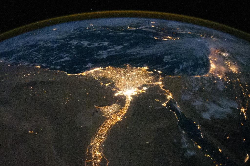
5 Rivers World s longest river, the Nile River; 4,000+ miles long. Over 95% of Egyptians depend on the Nile for water. Population density along the Nile is 3,320 per sq. mile. Congo and Niger Rivers
6


7 Geopolitical Impact of the Nile Who was a right to water?

8 Rift Valleys Long, thin valleys in East Africa that were formed when land sank into cracks in the earth caused by continental plates pulling part. Stretch over 4,000 miles from Jordan to Mozambique.

9 Rift Valley

10 Rift Valley

11 Lakes Lake Tanganyika is the longest freshwater lake in the world and is located at the bottom of a rift valley. 420 miles long x 4,700+ ft. deep. Lake Victoria is Africa s largest lake; sits between 2 rift valleys; 2 nd largest freshwater lake in the world; only 270 ft. deep. Lake Tanganyika Lake Tanganyika

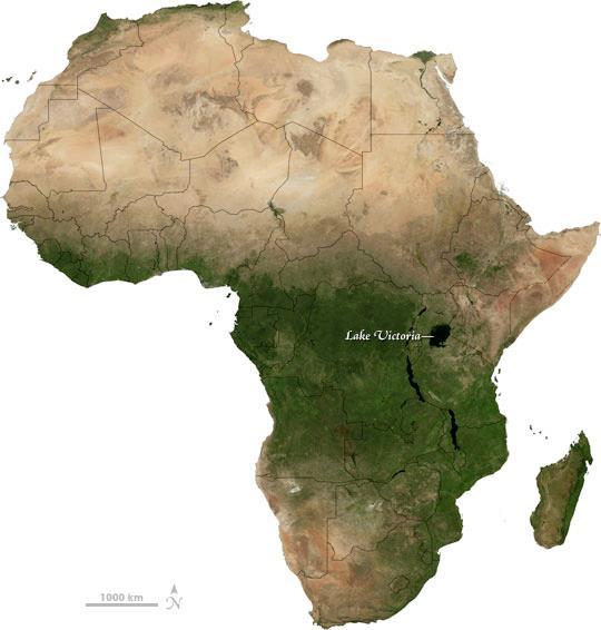
12 Lake Victoria


13 Mountains Mainly volcanic, Mount Kenya and including the tallest Mount Kilimanjaro ; Great Escarpment marks edge of the continents plateau in Southern Africa Escarpment: is a steep slope with a nearly flat plateau on top.

14 Mount Kenya
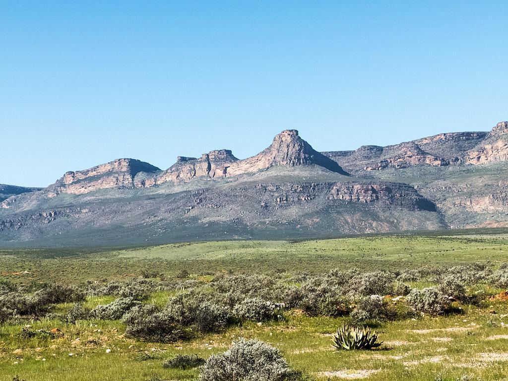
15 Escarpment


16 Mineral Wealth Large amounts of gold, platinum, chromium, cobalt, copper, phosphates & diamonds Benefited past colonial powers; Africa lacks the infrastructure & industries to benefit more fully


17 Energy Resources Libya, Nigeria & Algeria and Angola produce over 7% of the world s oil. Some Angolan oil money is channeled into civil war instead of their infrastructure; does not benefit Africans

, lumber, sugar, palm")
18 Commodities Agricultural is the single most important economic activity in Africa. Resources provide a livelihood for many Africans. Oil, coffee (20% of the world s supply), lumber, sugar, palm oil and cocoa beans. 1/3 of exports are farm products.
19 Chapter 18 Section 2 Climate and Vegetation


20 Deserts The Sahara is the largest desert in the world; stretches 3,000 miles east to west across north Africa & 1,200 miles north to south 20% Sand; the rest is mountains, rock formations and gravelly plains; An aquifer is a large storage of water underground. Water that comes to the surface is an oasis which supports life and vegetation Kalahari, Namib and Libyan deserts

21 Namib Desert

22 Regions across the Sahara

23 Interesting Facts Sahara Desert World s hottest desert 3,600,000 sq mi Sand dunes can be up to 590ft The name is Arabic, meaning desert 6,000 ft under the surface are aquifers; underground water
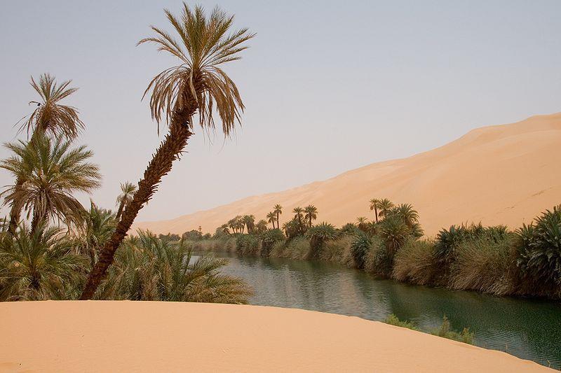
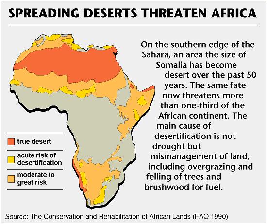
24 Oasis

25 Tropics Africa has largest tropical area of any continent 90% of the continent lies within the tropics of Cancer and Capricorn. July temperature averages


26 Moderate Areas Mediterranean climate on northern & southern tips of Africa Rainfall only in winter: January/December in North Africa & June/July in South Africa

27 Robertson Wine Valley, South Africa


28 Tropical Grasslands Cover most of the continent; Serengeti Plain, in north central Tanzania, contains some of the world s best grasslands Dry climate and hard soil prevent major tree growth; abundance of grasses, excellent for grazing animals
29


30 Rain Forests Mostly found on the equator in the Congo Basin Hot, moist air beneath an umbrella of vegetation that blocks most sunlight; home to a huge variety of species Canopy is the uppermost layer of branches, about 150 ft. above the ground and most animals live here.
31 Chapter 18 Section 3 Human-Environment Interaction


32 Environmental Issue Sahel: is a narrow band of dry grassland that runs along the southern edge of the Sahara. Used for farming and herding. Shore of the Desert in Arabic. Desertification: Expansion of dry conditions to moist areas that are next to deserts.

33 Causes Happens naturally but is sped up by overgrazing; farming, irrigation; trampling the soil; drilling for water; and indirectly by increasing population levels.

34 Results Destroys forests, including rainforests.
35
36
37


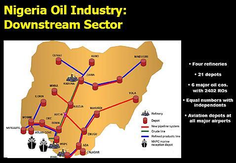
38 Oil in Nigeria Niger Delta contains most of Nigeria s oil % of Nigeria s income; huge potential for economic benefit. Spills and fires have harmed the land & people; bandits/corrupt officials have sabotaged pipelines for financial gain new president introduced economic reforms.
39


40 Aswan High Dam Completed in 1970; provides farmers with a regular supply of water, increasing the number of harvests per year from 1 to 2-3. Increased Egypt s farmable land by 50% and helped them avoid droughts and floods; more harvests Created the artificial Lake Nasser; 300 miles long

41 Aswan High Dam


42 Dam Problems Construction caused relocation of peoples and loss of ancient treasures. Decreased soil fertility near the Nile and increased fertilizer usage; rich silt; sediment, is no longer deposited. Increase in diseases like Malaria due to still water. Millions of gallons of freshwater are lost yearly due to evaporation.
Unit 6 vocabulary. Serengeti Plain
 basin Nile River rift valley Mount Kilimanjaro escarpment Sahara aquifer oasis Serengeti Plain canopy Niger delta Sahel the world s longest river, flowing more than 4,000 miles through Uganda and Sudan
STUDY GUIDE. The Land. Chapter 20, Section 1. The Land of Africa South of the Sahara. Landforms Water Systems Natural Resources.
 For use with textbook pages 499 504. The Land Terms to Know escarpment A steep, often jagged slope or cliff (page 500) cataract A towering waterfall (page 500) rift valley A large crack in the earth s
UNIT 5 PHYSICAL GEOGRAPHY SG 1 - PART I
 UNIT 5 PHYSICAL GEOGRAPHY SG 1 - PART I Africa is HUGE! I. LANDFORMS A. Plateaus - an area of relatively level high ground. 1. Africa s interior is dominated by series of plateaus and elevated basins such
Chapter 20. The Physical Geography of Africa South of the Sahara
 Chapter 20 The Physical Geography of Africa South of the Sahara Chapter Objectives Identify the major landforms, water systems, and natural resources of Africa south of the Sahara. Describe the relationship
Introduction to Africa
 Introduction to Africa Did you know? Africa has more countries than any other continent. The Sahara is a desert that is the size of the U.S. It s the world's largest desert. Most of the world s gold and
SS7G1 The student will locate selected features of Africa.
 Standards SS7G1 The student will locate selected features of Africa. a. Locate on a world and regional political-physical map: the Sahara, Sahel, savanna, tropical rain forest, Congo River, Niger River,
Brain Wrinkles. Africa: The impact of location, climate, & physical characteristics on where people live, the type of work they do, & how they travel
 Africa: The impact of location, climate, & physical characteristics on where people live, the type of work they do, & how they travel STANDARDS: SS7G3 The student will explain the impact of location, climate,
AFRICAN PHYSICAL GEOGRAPHY
 AFRICAN PHYSICAL GEOGRAPHY Here are some factoids about Africa: world s second largest continent (11,700,000 miles). Home to 52 countries, 1,000 languages, 800 million people. 10% of the world s population
How to play. The center aisle divides our class into 2 teams. Team members are NOT allowed to help their teammate when they are asked a question.
 Floaters & Sinkers How to play The center aisle divides our class into 2 teams. Each person will be responsible for answering a question for every round played. Team members are NOT allowed to help their
Physical characteristics and biomes:
 Physical characteristics and biomes: Sahel region, bordering Sahara Characteristics Area suffers from lack of rainfall, over grazing, which causes loss of vegetation and loss of inhabitable areas causing
Sub - Saharan Africa
 Sub - Saharan Africa 4/14/2015 Countries with Relative Importance GDP South Africa Gabon Botswana Land Size Sudan Chad Mozambique Madagascar Democratic Republic of the Congo (formerly Zaire) Population
Africa s. Presentation, Graphic Organizers, & Activities
 Africa s Presentation, Graphic Organizers, & Activities STANDARDS: SS7G1 Locate selected features of Africa. a. Locate on a world and regional political-physical map: Sahara, Sahel, savanna, tropical rain
Chapter 21: EAST AFRICA
 Chapter 21: EAST AFRICA Physical Geography of East Africa Landforms East Africa is a diverse landscape of different plains, volcanic mountains, and plateaus cut by a large valley and marked by many rivers
BRITANNICA STUDENT ENCYCLOPEDIA. Africa is the world s second largest continent. More than 50 countries make up
 JOBNAME: No Job Name PAGE: 33 SESS: 682 OUTPUT: Thu Aug 31 10:43:41 2006 38 Africa BRITANNICA STUDENT ENCYCLOPEDIA Africa Africa is the world s second largest continent. More than 50 countries make up
UNIT 5 AFRICA PHYSICAL GEOGRAPHY SG 1 - PART II
 UNIT 5 AFRICA PHYSICAL GEOGRAPHY SG 1 - PART II III. CLIMATE & VEGETATION A. The four main climate zones are tropical wet, tropical wet/dry (split into monsoon & savanna), semiarid, and arid. Other climate
STUDY GUIDE. The Land. Chapter 17, Section 1. There are frequent earthquakes in the region. Petroleum is a major export in the region.
 For use with textbook pages 421 426. The Land Terms to Know alluvial soil A rich soil made up of sand and mud deposited by flowing water (page 423) wadi A streambed that remains dry until a heavy rain
Africa: Physical geography
 Africa: Physical geography By National Geographic Society, adapted by Newsela staff on 09.15.17 Word Count 1,279 Level 1040L African elephants roam the savannas, which cover almost half of the African
Unit 9 The Middle East SG 1 - Physical Geography, Population & Demographics
 Unit 9 The Middle East SG 1 - Physical Geography, Population & Demographics I. Physical Geography A. The Middle East includes southwestern Asia and North Africa. 1. The name is Eurocentric. Middle East
Chapter 7 Geography and the Early Settlement of Egypt, Kush, and Canaan
 Chapter 7 Geography and the Early Settlement of Egypt, Kush, and Canaan How did geography affect early settlement in Egypt, Kush, and Canaan? Section 7.1 - Introduction RF/NASA//Corbis This satellite photograph
Rivers. Highlights of some of the World s Most Famous Rivers!
 Rivers Highlights of some of the World s Most Famous Rivers! Directions This Power Point presentation contains information about some of the most famous rivers in the world! Students should use this presentation
AFRICA'S PHYSICAL FEATURES
 AFRICA'S PHYSICAL FEATURES Looking high and low in Africa This continent's physical features are impressive. From towering, rocky peaks and sleeping volcanoes, like Mount Kilimanjaro, to some of the world
Using the exhibit, choose the letter of the best answer. (4 points each)
") Name: Date: Using the exhibit, choose the letter of the best answer. (4 points each) 1. Which of the following is the northernmost city located on the Nile River? A. Khartoum B. Cairo C. Omburman D. Alexandria
Name: Date: Using the exhibit, choose the letter of the best answer. (4 points each) 1. Which of the following is the northernmost city located on the Nile River? A. Khartoum B. Cairo C. Omburman D. Alexandria
Chapter 17. North Africa, Southwest Asia and Central Asia
 Chapter 17 North Africa, Southwest Asia and Central Asia Chapter Objectives Describe the major landforms and natural resources of North Africa, Southwest Asia, and Central Asia. Discuss the climate and
Ancient Egypt and the Near East
 *O*»f ' i ft Ancient Egypt and the Near East Chapter 7 Chapter 8 Chapter 9 Geography and the Early Settlement of Egypt, Kush, and Canaan The Ancient Egyptian P h a r a o h s Daily Life in Ancient Egypt
Chapter 13 and 14 Geography Study Guide
 Chapter 13 and 14 Geography Study Guide Multiple Choice Identify the letter of the choice that best completes the statement or answers the question. 1. Which West African country has the largest population
North Africa. Chapter 25. Chapter 25, Section
 Chapter 25, Section World Geography Chapter 25 North Africa Copyright 2003 by Pearson Education, Inc., publishing as Prentice Hall, Upper Saddle River, NJ. All rights reserved. Chapter 25, Section World
Friday, November 10, 2017
 Friday, November 10, 2017 Andes and Midlatitude Countries Objective: Summarize the main physical features and regions of the Southern Cone. Identify and locate the urban centers and understand the pattern
Chapter 7. Geography and the Early Settlement of Egypt, Kush, and Canaan
 Chapter 7 Geography and the Early Settlement of Egypt, Kush, and Canaan Chapter 7 Geography and the Early Settlement of Egypt, Kush, and Canaan How did geography affect early in Egypt Kush, and Canaan?
6th Grade Social Studies Chapter 7: The Geography and Early Settlement of Egypt, Kush and Canaan
 I. Introduction (7.1) A. Egyptians settled along the Nile River, in the NE corner of Africa B. civilization lasted from around 3100 B.C. to 350 C. E. C. Kushites settled to the south of Egypt, along the
Chapter 4. Ancient Egypt and Kush Section 1: Geography & Ancient Egypt
 Chapter 4 Ancient Egypt and Kush Section 1: Geography & Ancient Egypt The gift of the nile Geography played a key role in the development of the Egyptian civilization. The Nile River brought life to Egypt.
Chapter 7: The Geography and Settlement of Egypt, Kush, and Canaan
 Chapter 7: The Geography and Settlement of Egypt, Kush, and Canaan Learning Target: I can explain how geography affected early settlement in Egypt, Kush, and Canaan. Ancient Egypt and the Middle East Can
CHAPTER 12. South America. Section 1: Natural Environments Section 2: History and Culture Section 3: South America Today. HOLT World Geography
 CHAPTER 12 South America Section 1: Natural Environments Section 2: History and Culture Section 3: South America 1 Section 1 Natural Environments Objectives: What are the major landforms and rivers of
pg. 446 (5 th) pg. 456 (6 th )
 pg. 456 (6 th )") pg. 446 (5 th) pg. 456 (6 th ) African Landscape Plateau Highest in: Ethiopian Highlands Drakensberg Mtns. Lesotho & So. Africa pg. 452 (5 th) pg. 459 (6 th ) Ethiopian Highlands Canyons carved by water
pg. 446 (5 th) pg. 456 (6 th ) African Landscape Plateau Highest in: Ethiopian Highlands Drakensberg Mtns. Lesotho & So. Africa pg. 452 (5 th) pg. 459 (6 th ) Ethiopian Highlands Canyons carved by water
Geography (cont) Sorghum, rice, millet, rice, wheat and corn grown on savannahs. Not just one big plain though mountainous and swampy areas too
 Sorghum, rice, millet, rice, wheat and corn grown on savannahs. Not just one big plain though mountainous and swampy areas too") Geography & Society in Africa: 500 BCE-900 CE Geography Around 5000 miles wide and long Various climates, jungles, snow-capped mountains, deserts and rain-soaked areas. 40% desert - largely uninhabitable
Geography & Society in Africa: 500 BCE-900 CE Geography Around 5000 miles wide and long Various climates, jungles, snow-capped mountains, deserts and rain-soaked areas. 40% desert - largely uninhabitable
STUDY GUIDE. The Land. Physical Features of Latin America. Chapter 8, Section 1. Terms to Know DRAWING FROM EXPERIENCE ORGANIZING YOUR THOUGHTS
 For use with textbook pages 193 198. The Land Terms to Know cordillera A mountain range that runs parallel to another mountain range (page 194) altiplano A high plain (page 194) escarpment A steep cliff
*Latin America spans 7,000 miles, from Mexico to Tierra Del Fuego. *3 Regions: Central America, South America, and the Caribbean.
 Physical Geography Latin America spans 7,000 miles, from Mexico to Tierra Del Fuego *3 Regions: Central America, South America, and the Caribbean. *Intro clip: http://www.youtube.com/watch?v=cffp6rza3
One Commodity Map. 7. What is a commodity? 8. Explain what a one-commodity country is.
 7. What is a commodity? 8. Explain what a one-commodity country is. 9. What must African countries do in order to become more stable economically? One Commodity Map Countries which OIL is the lone commodity
Latin America. Chapter 9 Physical Geography
 Latin America Chapter 9 Physical Geography Latin American Regions Middle America includes Mexico and the Central American countries The Caribbean Islands South America Mexico Landforms Sierra Madre Oriental
Region 1 Piney Woods
 Region 1 Piney Woods Piney Woods 1. This ecoregion is found in East Texas. 2. Climate: average annual rainfall of 36 to 50 inches is fairly uniformly distributed throughout the year, and humidity and temperatures
Key Geographic Features
 DUE 12/6/18 Name: Lesson One: Egypt Geography 6.15 On a historical map locate the Mediterranean and Red Seas, the Nile River and Delta, and the areas of ancient Nubia and Egypt. Identify the locations
Latin America and The Caribbean. A Closer Look.
 Latin America and The Caribbean A Closer Look. Mexico Capital: Mexico City The Location of Mexico Mexico is the second-largest country by size and population in Latin America.but the Largest Spanish -
A funny sounding lake. South American Landforms, Climate, and Vegetation
 A funny sounding lake South American Landforms, Climate, and Vegetation 3 4 Essential Question: How have physical features and climate affected the population distribution of Latin America? 5 I. Landforms
Ancient Egypt. Land of the Pharaohs
 Ancient Egypt Land of the Pharaohs CHAPTER 4 EGYPT SECTION 1: GEOGRAPHY AND EARLY EGYPT BIG IDEA The water, fertile soils, and protected setting of the Nile Valley allowed a great civilization to arise
Africa. Display Transparency 6 on the overhead. Explain to students that Africa is the
 3S 4S 1S 2S 3N 4N Banjul Bissau SIERRA LEONE 5N MADEIRA IS. CANARY IS. (SPAIN) (disputed) Dakar Freetown (PORTUGAL) GAMBIA Bamako Conakry Monrovia Rabat BURKINA FASO 1W Accra Lomé ~ Niamey BENIN Algiers
Unit 1: Physical Geography Notes
 - How has the physical world impacted settlement patterns? o Major factors in the decision-making process of o Before the boom controlling the physical environment was not possible on a large scale - Physical
CH. 1 Europe and Russia: Physical Geography. Section 1 Land and Water p Europe and Russia are part of the world s largest landmass called.
 CH. 1 Europe and Russia: Physical Geography Section 1 Land and Water p.10-16 Europe and Russia are part of the world s largest landmass called. The country of Russia stretches over both continents. About
2.1 What is the climate like?
 José Medeiros This fact sheet allows you to see how varied the countryside is across Brazil. 2.1 What is the climate like? Most of Brazil is in the Southern Hemisphere, where the seasons are the opposite
CHAPTER 18 PHYSICAL GEOGRAPY OF AFRICA: THE PLATEAU CONTINENT
 UNIT 6 AFRICA CHAPTER 18 PHYSICAL GEOGRAPY OF AFRICA: THE PLATEAU CONTINENT 18.1 LANDFORMS AND RESOURCES The Plateau Continent Much of continent: Narrow lowlands near coasts Basins Depressions that span
Southern Africa. Countries, Geography, & Climate
 Countries, Geography, & Climate The Southern African region consists of the following countries: Angola Zambia Malawi Mozambique Zimbabwe Botswana Namibia Swaziland Lesotho South Africa Comoros Madagascar
Connecting Africa. physical Geography
 Connecting Africa physical Geography Africa, the second-largest continent, is bounded by the Mediterranean Sea, the Red Sea, the Indian Ocean, and the Atlantic Ocean. It is divided in half almost equally
GEOGRAPHY AND HISTORY
 GEOGRAPHY AND HISTORY YEAR 1, PART 1 www.vicensvives.es Contents 01 Our planet Earth 02 The representation of the Earth: maps 03 The Earth s relief 04 Rivers and seas 05 Weather and climate 06 Climates
ì<(sk$m)=bdicij< +^-Ä-U-Ä-U
=bdicij< +^-Ä-U-Ä-U") Genre Comprehension Skill Text Features Science Content Nonfiction Compare and Contrast Captions Diagrams Rocks and Soil Labels Glossary Scott Foresman Science 3.7 ì
Genre Comprehension Skill Text Features Science Content Nonfiction Compare and Contrast Captions Diagrams Rocks and Soil Labels Glossary Scott Foresman Science 3.7 ì
Latin America. Physical Geography
 + Latin America Physical Geography + I. Landforms A. Caribbean & Central America 1. Mexico is dominated by two mountain chains, collectively called the Sierra Madre. A high plateau is situated in between.
2009 Carole Marsh/Gallopade International
 Live Work Play Learn LIVE LEARN WORK TM PLAY 2009 Carole Marsh/Gallopade International Permission is hereby granted to the individual purchaser or classroom teacher to reproduce materials in this book
Grade 5 Geography Term 1
 1 Grade 5 Geography Term 1 Contents Section 1: World map and compass directions... 2 The position of the equator and the North and South Poles on a globe... 2 The seven continents of the world... 3 The
Objective. Students will familiarize themselves with the physical features and climates of Latin America.
 Journal Write KWL What do you KNOW about Latin America? What do you WANT TO KNOW about Latin America? What did you LEARN today that you didn t know before? Latin America Objective Students will familiarize
Gambia vs Ethiopia Gambia Ethiopia. Wednesday, March 21, 12
 Gambia vs Ethiopia Gambia Ethiopia Climate Change Gambia s normal climate is subtropical. Slightly dry and rainy. But recently there has been climate change and the country s capital is said to be completely
Chapter 14. The Physical Geography of Russia
 Chapter 14 The Physical Geography of Russia Chapter Objectives Identify the physical features and natural resources of Russia. Discuss the effects of Russia s climate and vegetation on life in the region.
The W20. The 20 wealthiest countries in the world. Publication Date: October 2015 NEW WORLD WEALTH
 The W20 The 20 wealthiest countries in the world Publication Date: October 2015 W20 wealth rankings The following tables ranks the top 20 countries in the world by total individual wealth held. Total individual
CONTENTS Executive Summary... iii 1. Introduction Major Destinations for Zambia s Exports Major Source Countries for Zambia s
 Bank of Zambia CONTENTS Executive Summary... iii 1. Introduction... 1 2. Major Destinations for Zambia s Exports... 1 3. Major Source Countries for Zambia s Imports... 4 4. Conclusion... 6 ii Executive
7/27/2010. Regions of Subsaharan Africa. SUBSAHARAN AFRICA II (Chapter 6, pages ) Southern Africa. South Africa: Peaceful Change from Apartheid
 Southern Africa. South Africa: Peaceful Change from Apartheid") SUBSAHARAN AFRICA II (Chapter 6, pages 209-227) Regions of Subsaharan Africa Southern Africa 10 countries, 6 of them landlocked Congo Basin marks northern limit Plateau country Rich in natural resources
SUBSAHARAN AFRICA II (Chapter 6, pages 209-227) Regions of Subsaharan Africa Southern Africa 10 countries, 6 of them landlocked Congo Basin marks northern limit Plateau country Rich in natural resources
Label your Map with Russia. Map Activity
 Bell Activity How many time zones does the U.S. have? How do these time zones affect life in the U.S.? Russia is so large it has 11 time zones. What difficulties might this create? Objectives Know landforms,
Ancient River Valley Civilizations Egypt
 Ancient River Valley Civilizations Egypt Geography of Egypt The first civilization in Africa developed along the Nile River, in a place called Egypt. These humans were at first nomadic, also known as hunter-gatherers.
EXPLORING BIOMES IN GORONGOSA NATIONAL PARK
 EXPLORING BIOMES IN GORONGOSA NATIONAL PARK ABOUT THIS WORKSHEET This worksheet complements the Click and Learn Gorongosa National Park Interactive Map (http://www.hhmi.org/biointeractive/gorongosa-national-park-interactive-map),
PHYSICAL GEOGRAPHY. Unit 1
 PHYSICAL GEOGRAPHY Unit 1 HOW HAS THE PHYSICAL WORLD IMPACTED SETTLEMENT PATTERNS? Major factor in the decision-making process of settlers Before the technological boom controlling the physical environment
Middle East Part I Notes
 Middle East Part I Notes What do we already know about the Middle East? What do we already know about the Middle East? Pre-Test 1. T/F- The U.S. is currently fighting a war in the Middle East. 2. Which
North Africa. countries to Europe. Oil is most important industry. Mining and metal work are important, too.
 North Africa CHAPTER SUMMARY North Africa Egypt It has large areas of desert. The Nile supports fertile farmland. Nomadic Bedouins herd livestock. The Suez Canal is a strategic waterway. Most people are
Terms to Know. artesian well coral atoll krill lagoon
 Chapter Objectives Describe the diverse landforms and natural resources of Australia, Oceania, and Antarctica. Discuss the wide range of climates and vegetation throughout the region. The Land Section
LOCATION, CLIMATE, AND NATURAL RESOURCES OF MEXICO
 SS6G3 The student will explain the impact of location, climate, distribution of natural resources, and population distribution on Latin America and the Caribbean. a. Compare how the location, climate,
Location, Climate, & Natural Resources
 Location, Climate, & Natural Resources UK is a country of islands off the coast of mainland Europe. It consists of England, Northern Ireland, Scotland, & Wales. UK s location makes it a HUB for trade.
Oceania. Australia, New Zealand, and the Pacific Islands. Physical Geography. Where is Australia located?
 Oceania Australia, New Zealand, and the Pacific Islands Physical Geography Australia New Zealand Oceania Where is Australia located? Australia & Oceania are a group of islands located between Asia, Antarctica,
Notes for the Teacher / Guide. Africa / Uganda
 Notes for the Teacher / Guide Africa / Uganda The aim of the project is to introduce the children of the UK to the landscape of another country and to appreciate similarities and differences. Uganda is
CONTENTS Executive Summary... iii 1. Introduction Major Destinations for Zambia s Exports Major Source Countries for Zambia s
 Bank of Zambia CONTENTS Executive Summary... iii 1. Introduction... 1 2. Major Destinations for Zambia s Exports... 1 3. Major Source Countries for Zambia s Imports... 4 4. Conclusion... 6 ii Executive
Lesson 1: Geography of Africa
 Lesson 1: Geography of Africa 7. 4. 1 Study the Niger River and the relationship of Vegetation zones of forest, savannah, and desert trade in gold, salt, food, and slaves; and the growth of the Ghana and
What Is An Ecoregion?
 Ecoregions of Texas What Is An Ecoregion? Ecoregion a major ecosystem with distinctive geography, characteristic plants and animals, and ecosystems that receives uniform solar radiation and moisture Sometimes
Lakes of Africa. 2. What are two important uses people make of Lake Tanganyika? 4. What are some characteristics of Lake Chad?
 World Lakes Name: Lakes of Africa 1. Why is Lake Tanganyika so long and narrow? 2. What are two important uses people make of Lake Tanganyika? 3. What famous river begins near Lake Victoria? 4. What are
Ancient Egypt. Life Along the Nile River
 Ancient Egypt Life Along the Nile River 2018 Geography How Does Geography affect the way that people live? Geography- Where in the World? You are Here Streetsboro, Ohio United States of America Geography-
Location, Climate, & Natural Resources Brain Wrinkles
 Location, Climate, & Natural Resources Standards SS6G10 The student will explain the impact of location, climate, natural resources, and population distribution on Europe. a. Compare how the location,
CONTENTS Executive Summary... iii 1. Introduction Major Destinations for Zambia s Exports Major Source Countries for Zambia s
 Bank of Zambia CONTENTS Executive Summary... iii 1. Introduction... 1 2. Major Destinations for Zambia s Exports... 1 3. Major Source Countries for Zambia s Imports... 3 4. Conclusion... 6 ii Executive
How the Nile River Led to Civilization in Ancient Egypt
 How the Nile River Led to Civilization in Ancient Egypt By USHistory.org, adapted by Newsela staff on 03.07.17 Word Count 786 Level 950L TOP: This photo, taken around 1915, shows the flooding of the Nile
Geography of Ancient Greece Summary Sheet for Use in Assessment
 Geography of Ancient Greece Summary Sheet for Use in Assessment 1. At the same time that the Shang dynasty was ruling much of the Huang He River valley and the Egyptian pharaohs were building the New Kingdom
Opportunities and Risks in Africa
 Opportunities and Risks in Africa Africa is not a country Note: Graphic layout for visualization only (some countries are cut and rotated) Source: Creative Commons. Africa at a glance 212 Total GDP: $2.1
Chapters 14 and 15 Geography Study Guide
 Chapters 14 and 15 Geography Study Guide Multiple Choice Identify the letter of the choice that best completes the statement or answers the question. 1. Gorillas live within dense rain forests of. a. Rwanda
Appendix A Geographic and Geologic Terms Connected With Egypt
 Appendix A Geographic and Geologic Terms Connected With Egypt Egypt Official name is the Arab Republic of Egypt. Total area is 1,002,450 km 2, which makes Egypt the 29th largest country in the world. Only
Population (million) % of Africa
 % of Africa") FAO. Irrigation in in figures: AQUASTAT Survey 2005 TABLE 1 al distribution of cultivable and cultivated areas Cultivable areas Cultivated areas in 2002 In cultivable areas (ha) (ha) (%) Northern 65 320
FAO. Irrigation in in figures: AQUASTAT Survey 2005 TABLE 1 al distribution of cultivable and cultivated areas Cultivable areas Cultivated areas in 2002 In cultivable areas (ha) (ha) (%) Northern 65 320
G.H.S. GEOGRAPHY PAPER 2 S. 3 TIME: 2 Hours NOV. 2012
 G.H.S. GEOGRAPHY PAPER 2 S. 3 TIME: 2 Hours NOV. 2012 Answer three questions in all. Two questions should be answered from Part I and one question from Part II PART I 1. (a) Draw a sketch map of Africa
North Africa and Southwest Asia. Economic Geography
 North Africa and Southwest Asia Economic Geography Natural Resources Oil is the major resource in this region. Many countries in this region are members of OPEC (Organization of Petroleum Exporting Countries).
Module 1 Educator s Guide: Representative Discussion Points Investigation 3
 Module 1 Educator s Guide: Representative Discussion Points Investigation 3 Ethiopia and Eritrea Our combined population is 59,578,171 people. We have just emerged from a long period of civil war and famine.
MCGRAW-HILL EUROPE. Chapter 11 Physical Geography Pages 332 to 341
 MCGRAW-HILL EUROPE Chapter 11 Physical Geography Pages 332 to 341 Countries of Western Europe Benelux Countries UK, France, Luxembourg, Germany, Netherlands, Belgium, Austria, Switzerland, Belgium, Monaco,
Chapter 4 : Ancient Egypt and Kush
 Chapter 4 : Ancient Egypt and Kush Chapter 4 Section 1 Geography and Ancient Egypt The Nile River is the most important thing in Egypt. The Nile is the longest river in the world. It stretches about 4000
Latin America. Introduction
 Latin America Introduction What are the 5 Themes of Geography? Draw lines to connect the theme to the definition: Location How humans and the environment impact each other Physical and human characteristics
Monday, December 11, 2017
 Monday, December 11, 2017 Physical Geography of Russia Objective: complete Warm-Up, write outline notes and discuss the geography of Eastern Europe/mother Russia and view Geography Now: Belarus. География
THE GEOGRAPHY OF THE NILE. Section 1
 THE GEOGRAPHY OF THE NILE Section 1 The Nile River is the world s longest river. It flows north from its sources in East Africa to the Mediterranean Sea for more than 4,000 miles. THE COURSE OF THE NILE
International Boundary Study. Tanzania Uganda Boundary
 International Boundary Study No. 55 September 1, 1965 Tanzania Uganda Boundary (Country Codes: TZ-UG) The Geographer Office of the Geographer Bureau of Intelligence and Research INTERNATIONAL BOUNDARY
Vocabulary Words. predict inundation deity afterlife. mummy cataract nation-state dynasty
 The Gift of Nile Vocabulary Words predict inundation deity afterlife mummy cataract nation-state dynasty Predict Predict: To tell ahead of time what will happen. Inundation Inundation; Annual flooding
1.0 Introduction Zambia s Major Trading Partners Zambia s Major Export Markets... 4
 Bank of Zambia CONTENTS 1.0 Introduction... 3 2.0 Zambia s Major Trading Partners... 3 3.0 Zambia s Major Export Markets... 4 4.0 Major Source Countries Of Zambia s Imports... 5 5.0 Direction Of Trade
COUNTRY CASE STUDIES: OVERVIEW
 APPENDIX C: COUNTRY CASE STUDIES: OVERVIEW The countries selected as cases for this evaluation include some of the Bank Group s oldest (Brazil and India) and largest clients in terms of both territory
You Will Need: Your notebook Your textbook Your pencil
 You Will Need: Your notebook Your textbook Your pencil Today you will learn about the kingdoms of Kush and Aksum who developed advanced civilizations with large trading networks. Kush and Aksum Kush and
Portuguese Language - Fostering National Unity
 Geography Brazil Brazil Portuguese Language - Fostering National Unity 11 dialects of Portuguese Influenced by Amerindian and African languages, creating differences between Portuguese spoken in Brazil
JABALI AFRICAN ACROBATS TEACHER'S NOTES
 JABALI AFRICAN ACROBATS TEACHER'S NOTES Brought to you by Class Act Performing Artists & Speakers; 800-808-0917 JABALI ACROBATS This incredible Kenyan troupe combines Chinese and African traditions of