AFRICAN PHYSICAL GEOGRAPHY
|
|
|
- Alberta Booth
- 6 years ago
- Views:
Transcription

1 AFRICAN PHYSICAL GEOGRAPHY
. Home to 52 countries, 1,000 languages, 800 million people.")

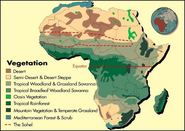
2 Here are some factoids about Africa: world s second largest continent (11,700,000 miles). Home to 52 countries, 1,000 languages, 800 million people. 10% of the world s population lives in Africa. Africa Africa can be divided into many different regions: The Sahara The Sahel Savannahs Tropical Rain Forests Southern Africa.
3 Climate and Vegetation Tropical Wet - Located near the equator = warm temperatures 60 inches of rainfall, seasonal Dense shrubs, ferns and mosses (rainforests) Soil is not fertile because of the heavy of rains leach = dissolve, and carry away nutrients Crops: Bananas, pineapples, cocoa, tea, coffee and cotton Tropical Dry Savanas Not very fertile soil Wettest near the equator Wet Season > daily rainfall for 6 months Dry Season > no rain Duelling Winds - Harmattan Hot dry air streams from the Sahara, NE trade winds dries up the summer moisture Cool, humid air from the Southwest Collision of two winds = tornadoes
4


5 SAHARA DESERT Largest desert in the world Covers 1/3 of continent Divides Continent in 2 North Africa Sub-Saharan There are two main types of landscape in the Sahara Erg sand dunes Reg gravel covered plain

6 Semi-arid region just south of the Sahara - dry grasslands The word Sahel means border or margin. Region between the desert to the north and the grasslands and rainforest to the south. Vegetation is sparse Relatively flat with few mountains and hills.


7 SAHEL Separates the tropical dry savanna and deserts From Senegal to Sudan Slowly turning into desert. Caused by climate changes and over grazing Desertification the transformation arable land to desert


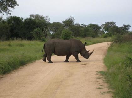
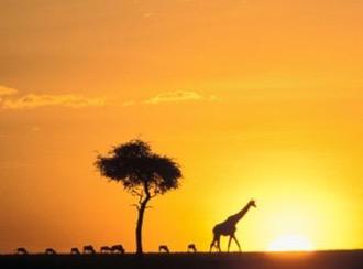
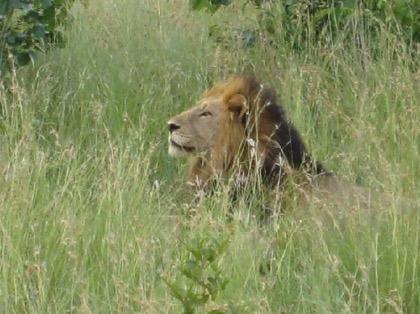
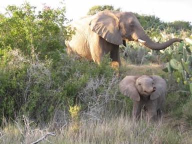
8 SAVANNAS Tropical grasslands with scattered trees and shrubs located near the Equator Cover 1/2 of Africa North and South of Rainforest Region This is where many of the African Safaris take place Large populations of wildlife Lions, zebra and elephants Good farming but little rainfall Mostly heavily populated area Serengeti means endless plains Largest mammal migration and game reserve
9


10 Located along the central coast of Africa, near the Equator. It lies in the Congo River Basin. Tropical Rain Forest Covers 1/5 th of the land surface and touches 37 countries. The rain forest has a hot, humid climate. The annual rainfall is over 17 feet. There is a large variety of animals found in this region. Trees: Teak and mahogany Trees are so thick and tall that sunlight never reaches the forest floor! Second largest rain forest in the world Variety of fruits, nuts, seeds, leaves and flowers Attracts a variety if animals Tse Tse Fly - harmful to humans and fatal to most hoofed animals

11


12 CONGO RIVER Located in Western and Central Africa Begins near Lake Tanganyika Flows west Second largest river in Africa


13 Niger River Great River Originates in the highlands of Guinea Creates and arc by flowing Northeast then Southeast to the Nigerian coast Located in western Africa. It flows through Guinea, Mali, Niger, Benin, & Nigeria. Third largest river in Africa. It runs over 2,600 miles


14 The Nile River Longest River in the World White Nile and Blue Nile meet in Sudan to form the Nile River Flows northward, emptying in the Mediterranean Sea Without the annual flooding in Egypt land would not be arable
15 Other Water Systems Lake Chad Located in Western/Central Africa Threatened with extinction, it is shrining Landlocked Global Warming Irrigation Desertification Lake Malawi - Mountain rimmed lake Lake Volta Located in West Africa Largest human made lake Created in 1960 and is used for hydroelectric power Damed south of Ajena, Ghana


16 The Great Rift Valley Located in Eastern Africa Largest Rift Valley in the world Caused by the diverging Indian Tectonic Plate Surrounding lakes and rivers are very deep


17 Lake Victoria Located in the middle of the Great Rift Valley of Eastern Africa It is a shallow depression Largest lake in Africa


18 Zambezi River Located in South/Central Africa Forms the Zambia and Angola Border flows into the Indian Ocean 2,200 miles but interrupted by waterfalls biggest is Victoria Falls Victoria Falls Creates the border between Zambia and Zimbabwe Second largest waterfall in the world
19


20 Lake Tanganyika Located in central Africa. Divided between Burundi, Congo, Tanzania, and Zambia. Deepest lake in Africa and one of the deepest in the world. One of the largest freshwater lakes in the world.


21 Mount Kilimanjaro: Africa s highest mountain at 19,341 feet Located on the Equator in Tanzania near Kenya Formed by volcanic activity from the Great Rift Valley Only year round snow capped mountain in Africa Known in Swahili as Shining Mountain
22 Mountains and Plateaus Eastern Highlands Located in Ethiopia down to the Cape of Good Hope Highest summits are Mt Kilimanjaro and Mount Kenya Ruwenzori Mountains Mountains of the Moods West of the Eastern Highlands Snow and cloud covered due to the moist air from the Indian Ocean Divides Uganda and the Democratic Republic of Congo Drakensberg Range South Africa and Lesotho Forms an escarpment along the southern edge of the continent


23 Okavango Swamp/ River Worlds largest inland river delta River is absorbed by the Kalahari Desert Large game reserve in the desert


24 Kalahari Desert Largest Desert in Southwestern Africa Has many oasis which makes it habitable Oasis vegetated areas in a desert caused by fresh water springs


25 CAPE OF GOOD HOPE Southern mot point of Africa Converging currents from the Indian and Atlantic Oceans make waters dangerous for sailing but great wildlife Only Place in the world Great Whites breach South African Penguins
26 Post Lecture Assignment Due - Thursday January 11th or Friday January 12th 1. Complete one of the following 1. Write a fictional story (1 page in length) about the time you and your family took a trip safari through Africa. Begin in the Sahara desert and continue through the Sahel, Savanna and the rainforest. Describe your surroundings and the people you encounter. You must use all the information provided in the lecture, but you are welcome to add information you find from your country fact sheets and other research 2. Write a poem/rap/song to help use visualize the physical landscape of Africa. You must use all the information provided in the lecture. 2. Complete the following 1. Using unlined paper create a postcard depicting one of the physical features described in the lecture that you thought was the most interesting. (see next slide for sample/directions) 1. Front of Post Card = Picture of landscape 2. Back of Post Card = Brief description of what and where the landscape is located (i paragraph)


27 Right top corner = extra points, create an African stamp Front of postcard is a picture of the location Back of Postcard Left side = description (1 paragraph) Right side = use my name and school address as the person you are sending this to
SS7G1 The student will locate selected features of Africa.
 Standards SS7G1 The student will locate selected features of Africa. a. Locate on a world and regional political-physical map: the Sahara, Sahel, savanna, tropical rain forest, Congo River, Niger River,
STUDY GUIDE. The Land. Chapter 20, Section 1. The Land of Africa South of the Sahara. Landforms Water Systems Natural Resources.
 For use with textbook pages 499 504. The Land Terms to Know escarpment A steep, often jagged slope or cliff (page 500) cataract A towering waterfall (page 500) rift valley A large crack in the earth s
Chapter 20. The Physical Geography of Africa South of the Sahara
 Chapter 20 The Physical Geography of Africa South of the Sahara Chapter Objectives Identify the major landforms, water systems, and natural resources of Africa south of the Sahara. Describe the relationship
Africa s. Presentation, Graphic Organizers, & Activities
 Africa s Presentation, Graphic Organizers, & Activities STANDARDS: SS7G1 Locate selected features of Africa. a. Locate on a world and regional political-physical map: Sahara, Sahel, savanna, tropical rain
Introduction to Africa
 Introduction to Africa Did you know? Africa has more countries than any other continent. The Sahara is a desert that is the size of the U.S. It s the world's largest desert. Most of the world s gold and
UNIT 5 PHYSICAL GEOGRAPHY SG 1 - PART I
 UNIT 5 PHYSICAL GEOGRAPHY SG 1 - PART I Africa is HUGE! I. LANDFORMS A. Plateaus - an area of relatively level high ground. 1. Africa s interior is dominated by series of plateaus and elevated basins such
Sub - Saharan Africa
 Sub - Saharan Africa 4/14/2015 Countries with Relative Importance GDP South Africa Gabon Botswana Land Size Sudan Chad Mozambique Madagascar Democratic Republic of the Congo (formerly Zaire) Population
Just how big is Africa?
 The United States China India The United Kingdom Portugal Spain France Belgium Germany The Netherlands Switzerland Italy Eastern Europe Japan 11.7 million sq. miles Just how big is Africa? Chapter 18 Section
Brain Wrinkles. Africa: The impact of location, climate, & physical characteristics on where people live, the type of work they do, & how they travel
 Africa: The impact of location, climate, & physical characteristics on where people live, the type of work they do, & how they travel STANDARDS: SS7G3 The student will explain the impact of location, climate,
Physical characteristics and biomes:
 Physical characteristics and biomes: Sahel region, bordering Sahara Characteristics Area suffers from lack of rainfall, over grazing, which causes loss of vegetation and loss of inhabitable areas causing
How to play. The center aisle divides our class into 2 teams. Team members are NOT allowed to help their teammate when they are asked a question.
 Floaters & Sinkers How to play The center aisle divides our class into 2 teams. Each person will be responsible for answering a question for every round played. Team members are NOT allowed to help their
Africa: Physical geography
 Africa: Physical geography By National Geographic Society, adapted by Newsela staff on 09.15.17 Word Count 1,279 Level 1040L African elephants roam the savannas, which cover almost half of the African
Unit 6 vocabulary. Serengeti Plain
 basin Nile River rift valley Mount Kilimanjaro escarpment Sahara aquifer oasis Serengeti Plain canopy Niger delta Sahel the world s longest river, flowing more than 4,000 miles through Uganda and Sudan
Grade 5 Geography Term 1
 1 Grade 5 Geography Term 1 Contents Section 1: World map and compass directions... 2 The position of the equator and the North and South Poles on a globe... 2 The seven continents of the world... 3 The
Connecting Africa. physical Geography
 Connecting Africa physical Geography Africa, the second-largest continent, is bounded by the Mediterranean Sea, the Red Sea, the Indian Ocean, and the Atlantic Ocean. It is divided in half almost equally
UNIT 5 AFRICA PHYSICAL GEOGRAPHY SG 1 - PART II
 UNIT 5 AFRICA PHYSICAL GEOGRAPHY SG 1 - PART II III. CLIMATE & VEGETATION A. The four main climate zones are tropical wet, tropical wet/dry (split into monsoon & savanna), semiarid, and arid. Other climate
One Commodity Map. 7. What is a commodity? 8. Explain what a one-commodity country is.
 7. What is a commodity? 8. Explain what a one-commodity country is. 9. What must African countries do in order to become more stable economically? One Commodity Map Countries which OIL is the lone commodity
Population (million) % of Africa
 % of Africa") FAO. Irrigation in in figures: AQUASTAT Survey 2005 TABLE 1 al distribution of cultivable and cultivated areas Cultivable areas Cultivated areas in 2002 In cultivable areas (ha) (ha) (%) Northern 65 320
FAO. Irrigation in in figures: AQUASTAT Survey 2005 TABLE 1 al distribution of cultivable and cultivated areas Cultivable areas Cultivated areas in 2002 In cultivable areas (ha) (ha) (%) Northern 65 320
pg. 446 (5 th) pg. 456 (6 th )
 pg. 456 (6 th )") pg. 446 (5 th) pg. 456 (6 th ) African Landscape Plateau Highest in: Ethiopian Highlands Drakensberg Mtns. Lesotho & So. Africa pg. 452 (5 th) pg. 459 (6 th ) Ethiopian Highlands Canyons carved by water
pg. 446 (5 th) pg. 456 (6 th ) African Landscape Plateau Highest in: Ethiopian Highlands Drakensberg Mtns. Lesotho & So. Africa pg. 452 (5 th) pg. 459 (6 th ) Ethiopian Highlands Canyons carved by water
Chapter 13 and 14 Geography Study Guide
 Chapter 13 and 14 Geography Study Guide Multiple Choice Identify the letter of the choice that best completes the statement or answers the question. 1. Which West African country has the largest population
2009 Carole Marsh/Gallopade International
 Live Work Play Learn LIVE LEARN WORK TM PLAY 2009 Carole Marsh/Gallopade International Permission is hereby granted to the individual purchaser or classroom teacher to reproduce materials in this book
Ten Day Climate Watch Bulletin N 27 Dekad 21 st to 30 th September, 2014
 African Centre of Meteorological Application for Development Centre Africain pour les Applications de la Météorologie au Développement Ten Day Climate Watch Bulletin N 27 Dekad 21 st to 30 th September,
1. CLIMATIC AND ENVIRONMENTAL CONDITIONS OVER AFRICA. 1.1 Inter-Tropical Discontinuity (ITD)
") African Centre of Meteorological Application for Development Centre Africain pour les Applications de la Météorologie au Développement DECEMBER 2011 HIGHLIGHT: Cholera, Yellow fever, Avian Influenza, typhoid
African Centre of Meteorological Application for Development Centre Africain pour les Applications de la Météorologie au Développement DECEMBER 2011 HIGHLIGHT: Cholera, Yellow fever, Avian Influenza, typhoid
JABALI AFRICAN ACROBATS TEACHER'S NOTES
 JABALI AFRICAN ACROBATS TEACHER'S NOTES Brought to you by Class Act Performing Artists & Speakers; 800-808-0917 JABALI ACROBATS This incredible Kenyan troupe combines Chinese and African traditions of
African Centre of Meteorological Applications for Development Centre Africain pour les Applications de la Météorologie au Développement
 African Centre of Meteorological Applications for Development Centre Africain pour les Applications de la Météorologie au Développement Ten Days Climate Diagnostics Bulletin N 03 Dekad 3, 21 st to 31 st
GeoQuest Study for the next Quiz Day:
 GeoQuest Study for the next Quiz Day: February 27 th Angola Botswana Burundi Level 2 February Southern Africa Level 1 Republic of the Congo Democratic Republic of the Congo Equatorial Guinea Level 3 Madagascar
Rivers. Highlights of some of the World s Most Famous Rivers!
 Rivers Highlights of some of the World s Most Famous Rivers! Directions This Power Point presentation contains information about some of the most famous rivers in the world! Students should use this presentation
AFRICA'S PHYSICAL FEATURES
 AFRICA'S PHYSICAL FEATURES Looking high and low in Africa This continent's physical features are impressive. From towering, rocky peaks and sleeping volcanoes, like Mount Kilimanjaro, to some of the world
African Centre of Meteorological Applications for Development Centre Africain pour les Applications de la Météorologie au Développement
 African Centre of Meteorological Applications for Development Centre Africain pour les Applications de la Météorologie au Développement Ten Day Climate Watch Bulletin N 34 Dekad 1 st to 10 th December,
Chapter 21: EAST AFRICA
 Chapter 21: EAST AFRICA Physical Geography of East Africa Landforms East Africa is a diverse landscape of different plains, volcanic mountains, and plateaus cut by a large valley and marked by many rivers
African Centre of Meteorological Applications for Development Centre Africain pour les Applications de la Météorologie au Développement
 African Centre of Meteorological Applications for Development Centre Africain pour les Applications de la Météorologie au Développement Ten Day Climate Watch Bulletin N 15 Dekad 21 st to 31 st May, 2015
CLIMATE DIAGNOSTIC BULLETIN FOR AFRICA
 CLIMATE DIAGNOSTIC BULLETIN FOR AFRICA N 02 FEBRUARY, 2019 OCEAN-ATMOSPHERE MONITORING & PREDICTION 1 SUMMARY FEBRUARY 2019 The precipitation for the month of February, 2019 was above to well above average
BRITANNICA STUDENT ENCYCLOPEDIA. Africa is the world s second largest continent. More than 50 countries make up
 JOBNAME: No Job Name PAGE: 33 SESS: 682 OUTPUT: Thu Aug 31 10:43:41 2006 38 Africa BRITANNICA STUDENT ENCYCLOPEDIA Africa Africa is the world s second largest continent. More than 50 countries make up
Notes for the Teacher / Guide. Africa / Uganda
 Notes for the Teacher / Guide Africa / Uganda The aim of the project is to introduce the children of the UK to the landscape of another country and to appreciate similarities and differences. Uganda is
Lesson 1: Geography of Africa
 Lesson 1: Geography of Africa 7. 4. 1 Study the Niger River and the relationship of Vegetation zones of forest, savannah, and desert trade in gold, salt, food, and slaves; and the growth of the Ghana and
Table A.LPG1 : TOTAL LPG CONSUMPTION (Best available Estimates)
") Table A.LPG1 : TOTAL LPG CONSUMPTION (Best available Estimates) 1000 MT 1 Burkina Faso 0.509 0.587 0.615 0.606 0.435 0.429 0.691 1.057 1.385 1.698 2.156 2.432 2.888 2 Cape Verde 4.058 4.268 4.988 5.259
Table A.LPG1 : TOTAL LPG CONSUMPTION (Best available Estimates) 1000 MT 1 Burkina Faso 0.509 0.587 0.615 0.606 0.435 0.429 0.691 1.057 1.385 1.698 2.156 2.432 2.888 2 Cape Verde 4.058 4.268 4.988 5.259
African Centre of Meteorological Applications for Development Centre Africain pour les Applications de la Météorologie au Développement
 African Centre of Meteorological Applications for Development Centre Africain pour les Applications de la Météorologie au Développement Ten Day Climate Watch Bulletin N 26 Dekad 11 th to 20 th September,
Chapters 14 and 15 Geography Study Guide
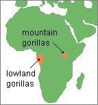
 Chapters 14 and 15 Geography Study Guide Multiple Choice Identify the letter of the choice that best completes the statement or answers the question. 1. Gorillas live within dense rain forests of. a. Rwanda
GEOGRAPHY AND HISTORY
 GEOGRAPHY AND HISTORY YEAR 1, PART 1 www.vicensvives.es Contents 01 Our planet Earth 02 The representation of the Earth: maps 03 The Earth s relief 04 Rivers and seas 05 Weather and climate 06 Climates
Chapter 17. North Africa, Southwest Asia and Central Asia
 Chapter 17 North Africa, Southwest Asia and Central Asia Chapter Objectives Describe the major landforms and natural resources of North Africa, Southwest Asia, and Central Asia. Discuss the climate and
7/27/2010. Regions of Subsaharan Africa. SUBSAHARAN AFRICA II (Chapter 6, pages ) Southern Africa. South Africa: Peaceful Change from Apartheid
 Southern Africa. South Africa: Peaceful Change from Apartheid") SUBSAHARAN AFRICA II (Chapter 6, pages 209-227) Regions of Subsaharan Africa Southern Africa 10 countries, 6 of them landlocked Congo Basin marks northern limit Plateau country Rich in natural resources
SUBSAHARAN AFRICA II (Chapter 6, pages 209-227) Regions of Subsaharan Africa Southern Africa 10 countries, 6 of them landlocked Congo Basin marks northern limit Plateau country Rich in natural resources
Africa. Display Transparency 6 on the overhead. Explain to students that Africa is the
 3S 4S 1S 2S 3N 4N Banjul Bissau SIERRA LEONE 5N MADEIRA IS. CANARY IS. (SPAIN) (disputed) Dakar Freetown (PORTUGAL) GAMBIA Bamako Conakry Monrovia Rabat BURKINA FASO 1W Accra Lomé ~ Niamey BENIN Algiers
Countries of the World QTR 3
 As of December 2017 Countries of the World QTR 3 Website: Countries of the World. com https://www.countries-ofthe-world.com/countries-of-north-america.html Website: CIA.gov https://www.cia.gov/index.html
M2 Africa Some Basic Facts (Part I) Africa (Year 7)
 Africa (Year 7)") M2 Africa Some Basic Facts (Part I) Africa (Year 7) Take a look in your atlas and find the names of the oceans and seas (numbers 1-8 on the map below) that surround Africa. Write their names in the grid
M2 Africa Some Basic Facts (Part I) Africa (Year 7) Take a look in your atlas and find the names of the oceans and seas (numbers 1-8 on the map below) that surround Africa. Write their names in the grid
EASTERN AFROMONTANE 1,043,191 km 2
 Egypt Saudi Arabia Oman EASTERN AFROMONTANE 1,043,191 km 2 Sudan Asmara Eritrea Yemen Djibouti Addis Ababa South Sudan Ethiopia BIODIVERSITY TARGET 2020 TARGET: 17% protected Democratic Republic of the
Objective. Students will familiarize themselves with the physical features and climates of Latin America.
 Journal Write KWL What do you KNOW about Latin America? What do you WANT TO KNOW about Latin America? What did you LEARN today that you didn t know before? Latin America Objective Students will familiarize
Latin America. Introduction
 Latin America Introduction What are the 5 Themes of Geography? Draw lines to connect the theme to the definition: Location How humans and the environment impact each other Physical and human characteristics
A Snapshot of Sanitation and Open Defecation in Africa 2010 Update
 A Snapshot of Sanitation and Open Defecation in 10 Update A regional perspective based on data from the WHO/UNICEF Joint Monitoring Programme for Water Supply and Sanitation UNICEF/NYHQ10-1999/Asselin
Discover the Ecology Botswana
 1 Module # 1 Component # 1 Introduction Discover the Ecology - Botswana Botswana is Africa s shining light. True democracy, peaceful people, honest politicians positive GDP growth and money in the bank
Terms to Know. artesian well coral atoll krill lagoon
 Chapter Objectives Describe the diverse landforms and natural resources of Australia, Oceania, and Antarctica. Discuss the wide range of climates and vegetation throughout the region. The Land Section
Unit 1: Physical Geography Notes
 - How has the physical world impacted settlement patterns? o Major factors in the decision-making process of o Before the boom controlling the physical environment was not possible on a large scale - Physical
RED CEDAR MODEL UNITED NATIONS. Table of Contents. Letter from the Chair Question of Water Security in Africa: Lake Chat...
 Table of Contents Letter from the Chair... 3 Question of Water Security in Africa: Lake Chat... 4 Introduction to Water Security in Africa... 4 History of Water Security in Africa... 5 Current Issues...
Regional outlook Sub-Saharan Africa 24/11/2015. Share commodities in good exports. Share commodities in goods imports
 Table 1: Economic structure indicators Number of Inhabitants (m.) Size of the economy (in USD bn.) Size of the economy (% of world GDP) Share commodities in good exports Share commodities in goods imports
Ecology and Conservation in Africa
 Ecology and Conservation in Africa Biology 100 Block 8, 2002 Bruce Byers, Visiting Professor Course Description This course will provide an overview of the ecology of Africa and of efforts to conserve
6th Grade Social Studies Chapter 7: The Geography and Early Settlement of Egypt, Kush and Canaan
 I. Introduction (7.1) A. Egyptians settled along the Nile River, in the NE corner of Africa B. civilization lasted from around 3100 B.C. to 350 C. E. C. Kushites settled to the south of Egypt, along the
Central Africa Climate?
 Sub-Saharan Africa: All the lands below the Sahara List 4 common traits of countries in Sub-Saharan Africa 4. Define Tribalism and explain how it has affects the region. Chapter 20 Study Guide Define animism
The A Z of African Countries Notebooking Pages with Backline Maps. Preface
 Preface This book has been created as the basis for unit studies on any (or all) African countries. Whilst each country has available a separate and comprehensive Unit Study, some educators prefer to start
All of this week s homework is intended to help you get to know more about the country of Sudan, where Kek is from in Home of the Brave.
 Name: Week 7 Homework All of this week s homework is intended to help you get to know more about the country of Sudan, where Kek is from in Home of the Brave. On the map above, do the following things:
What is new on the T4A GPS Maps Traveller s Africa 16.10
 What is new on the T4A GPS Maps Traveller s Africa 16.10 T4A GPS Maps 16.10 comes preloaded on a micro SD card with standard adapter, ready for Plug & Navigate. This SD card can be used on most map capable
STUDY GUIDE. The Land. Chapter 29, Section 1. Both. Terms to Know DRAWING FROM EXPERIENCE ORGANIZING YOUR THOUGHTS
 Chapter 29, Section 1 For use with textbook pages 719 724. The Land Terms to Know cordilleras Parallel mountain ranges and plateaus (page 719) archipelago A group of islands (page 720) insular Relating
Energy Poverty in Africa
 African Energy Commission (AFREC) Paper on Energy Poverty in Africa By Dr. Gilbert NZOBADILA Consultant Energy Policy- AFREC 1 1- Introduction: African background : The African Energy Commission (AFREC)
Prelim Bits
 Prelim Bits 19-03-2018 HAMMER Spacecraft NASA has drawn up plans to build a huge nuclear spacecraft that is capable of shunting or blowing up dangerous space rocks and safeguarding life on Earth. The spacecraft
Framework for Progressive Destination Competitiveness
 Sub-Saharan Africa Framework for Progressive Destination Competitiveness SSA Countries by Tourism Development Level and World Bank Income Ranking Tourism development level Pre-emerging Low income Central
KENYA. Soroldoni Simone Luciano Romeo; Mandelli Davide; Rivetti Alessia and Natali Andrea
 KENYA Soroldoni Simone Luciano Romeo; Mandelli Davide; Rivetti Alessia and Natali Andrea HISTORY 2000 BC Cushitic-people 1 century AD 1 millennium Arabs traders, who established Arab and Persian colonies.
countries include the Republic of Benin, Chad. Cameroon, and Niger. These countries surround
 Nigeria Location Nigeria is located in West Africa and it shares land borders with a few countries. These countries include the Republic of Benin, Chad. Cameroon, and Niger. These countries surround Nigeria
Chapter 7 Geography and the Early Settlement of Egypt, Kush, and Canaan
 Chapter 7 Geography and the Early Settlement of Egypt, Kush, and Canaan How did geography affect early settlement in Egypt, Kush, and Canaan? Section 7.1 - Introduction RF/NASA//Corbis This satellite photograph
Africa. Grades 2-5. Barbara Gillespie-Washington. Author
 Illustrators Cheri Macoubrie Wilson Wendy Chang Mary E. Connors Editor Barbara Wally Africa Grades 2-5 Editorial Project Manager Karen J. Goldfluss, M.S. Ed. Editor-in-Chief: Sharon Coan, M.S. Ed. Creative
The political economy of resource discoveries. Prof. Michael L. Ross UCLA Department of Political Science September 21, 2011
 The political economy of resource discoveries Prof. Michael L. Ross UCLA Department of Political Science September 21, 2011 Overview 1. Oil and mineral production is spreading to more low-income countries;
Africa. Physical. Map. Unit. Thanks for Your Purchase! Annabelle ate apples in the purple poppies Thomas Teaching Tools
 Africa Physical Map Unit Thanks for Your Purchase! I hope you and your students enjoy this product. If you have any questions, you may contact me at ThomasTeachingTools@gmail.com. Terms of Use This teaching
SUB-SAHARAN AFRICA (2): POPULATION AND SETTLEMENT GEOGRAPHY
: POPULATION AND SETTLEMENT GEOGRAPHY") SUB-SAHARAN AFRICA (2): POPULATION AND SETTLEMENT GEOGRAPHY 1. Introduction 2. Demographics: population growth and AIDS 3. Rural settlement patterns 4. Urban structures 5. Globalization and Africa: the
SUB-SAHARAN AFRICA (2): POPULATION AND SETTLEMENT GEOGRAPHY 1. Introduction 2. Demographics: population growth and AIDS 3. Rural settlement patterns 4. Urban structures 5. Globalization and Africa: the
NATIONAL SENIOR CERTIFICATE NATIONAL GRADE 12
 NATIONAL SENIOR CERTIFICATE NATIONAL GRADE 12 GEOGRAPHY P1 FEBRUARY/MARCH 2013 ANNEXURE This annexure consists of 12 pages. Geography/P1 2 DBE/Feb. Mar. 2013 FIGURE 1.1: GLOBAL PRESSURE BELTS AND WINDS
STUDY GUIDE. The Land. Chapter 17, Section 1. There are frequent earthquakes in the region. Petroleum is a major export in the region.
 For use with textbook pages 421 426. The Land Terms to Know alluvial soil A rich soil made up of sand and mud deposited by flowing water (page 423) wadi A streambed that remains dry until a heavy rain
Geography (cont) Sorghum, rice, millet, rice, wheat and corn grown on savannahs. Not just one big plain though mountainous and swampy areas too
 Sorghum, rice, millet, rice, wheat and corn grown on savannahs. Not just one big plain though mountainous and swampy areas too") Geography & Society in Africa: 500 BCE-900 CE Geography Around 5000 miles wide and long Various climates, jungles, snow-capped mountains, deserts and rain-soaked areas. 40% desert - largely uninhabitable
Geography & Society in Africa: 500 BCE-900 CE Geography Around 5000 miles wide and long Various climates, jungles, snow-capped mountains, deserts and rain-soaked areas. 40% desert - largely uninhabitable
2.1 What is the climate like?
 José Medeiros This fact sheet allows you to see how varied the countryside is across Brazil. 2.1 What is the climate like? Most of Brazil is in the Southern Hemisphere, where the seasons are the opposite
The Second Japan-Africa Business Forum TICAD and Business: Feedback from the Yokohama Action Plan to the Nairobi Declaration July 25, 2017
 The Second Japan-Africa Business Forum TICAD and Business: Feedback from the Yokohama Action Plan to the Nairobi Declaration July 25, 207 Takeshi Osuga Ambassador, Assistant Minister, Director-General
Southern Africa. Countries, Geography, & Climate
 Countries, Geography, & Climate The Southern African region consists of the following countries: Angola Zambia Malawi Mozambique Zimbabwe Botswana Namibia Swaziland Lesotho South Africa Comoros Madagascar
CH. 1 Europe and Russia: Physical Geography. Section 1 Land and Water p Europe and Russia are part of the world s largest landmass called.
 CH. 1 Europe and Russia: Physical Geography Section 1 Land and Water p.10-16 Europe and Russia are part of the world s largest landmass called. The country of Russia stretches over both continents. About
South American Countries. Capital Location Population Terrain Climate
 South American Countries Capital Location Population Terrain Climate Andes Mountains Four large areas that make up the Central Plains: Llanos, the Selva, the Gran Chaco, and the Pampas Brazilian Highlands
Africa's Top Wildlife Countries: Botswana, Kenya, Namibia, Rwanda, South Africa, Tanzania, Uganda, Zambia & Zimbabwe By Mark W.
 Africa's Top Wildlife Countries: Botswana, Kenya, Namibia, Rwanda, South Africa, Tanzania, Uganda, Zambia & Zimbabwe By Mark W. Nolting This is a list of national parks in Africa. The nature of the parks
Structure. Introduction
 1 Introduction Structure Demographic Dynamics in Africa Determinants of the Demographic Transition Human Development Payoffs Jobs Payoffs Economic Growth in Africa Policies to Speed up the Demographic
Emerald Group Publishing. The Horizon and Beyond with the African Library Summit
 Emerald Group Publishing The Horizon and Beyond with the African Library Summit Presented by Rejaene van Dyk Account Management Executive: Sub-Sahara Africa 05 July 2013, Unisa Senate Hall, South Africa
Namibia, formally The Republic of Namibia, is located in the southwestern region
 Namibia Location Namibia, formally The Republic of Namibia, is located in the southwestern region of the continent of Africa. Its western boarder is Atlantic coastline. Namibia borders The Republic of
What is new on the T4A GPS Maps Traveller s Africa 17.10
 What is new on the T4A GPS Maps Traveller s Africa 17.10 T4A GPS Maps 17.10 comes preloaded on a micro SD card with standard adapter, ready for Plug & Navigate. This SD card can be used on most map capable
Lakes of Africa. 2. What are two important uses people make of Lake Tanganyika? 4. What are some characteristics of Lake Chad?
 World Lakes Name: Lakes of Africa 1. Why is Lake Tanganyika so long and narrow? 2. What are two important uses people make of Lake Tanganyika? 3. What famous river begins near Lake Victoria? 4. What are
!!!!!!!!!!Mali s Geographic Makeup
 DANU Strategic Forecasting Group May 27th 2016!!!!!!!!!!Mali s Geographic Makeup By Liliana Pirlea Location: Mali is a landlocked country located in West Africa. Mali is the 8th largest country in Africa
Portuguese Language - Fostering National Unity
 Geography Brazil Brazil Portuguese Language - Fostering National Unity 11 dialects of Portuguese Influenced by Amerindian and African languages, creating differences between Portuguese spoken in Brazil
Latin America. Chapter 9 Physical Geography
 Latin America Chapter 9 Physical Geography Latin American Regions Middle America includes Mexico and the Central American countries The Caribbean Islands South America Mexico Landforms Sierra Madre Oriental
AGRICULTURE THE BIG PICTURE
 AGRICULTURE THE BIG PICTURE AEASA 2015 (30 Sept 2015), Parys North West NAMC and Tralac Collaboration By: B Nyhodo, E Williams and R Sandrey Presentation outline Introduction Africa Africa share of world
PHYSICAL GEOGRAPHY. Unit 1
 PHYSICAL GEOGRAPHY Unit 1 HOW HAS THE PHYSICAL WORLD IMPACTED SETTLEMENT PATTERNS? Major factor in the decision-making process of settlers Before the technological boom controlling the physical environment
A funny sounding lake. South American Landforms, Climate, and Vegetation
 A funny sounding lake South American Landforms, Climate, and Vegetation 3 4 Essential Question: How have physical features and climate affected the population distribution of Latin America? 5 I. Landforms
FAMILY PLANNING TRENDS IN SUB SAHARAN AFRICA:
 FAMILY PLANNING TRENDS IN SUB SAHARAN AFRICA: PROGRESS, PROSPECTS AND LESSONS LEARNED Mona Sharan, Saifuddin Ahmed, John May & Agnes Soucat Background : Sub Saharan Africa Highest TFR (5.1) compared to
Cambridge International Examinations Cambridge International Advanced Subsidiary and Advanced Level
 Cambridge International Examinations Cambridge International Advanced Subsidiary and Advanced Level *5153973671-I* TRAVEL AND TOURISM 9395/11 Paper 1 Core May/June 2016 INSERT 2 hours 30 minutes READ THESE
SRC 2010: JUNGLE BINGO Words
 SRC 2010: JUNGLE BINGO Words B Adventure B Ape B Binoculars B Boa Constrictor B Camp B Canteen B Cougar B Danger B Ecosystem B Elephant B Forest B Guides B Habitat B Jeep B King B Knife B Madagascar B
STUDY GUIDE. The Land. Physical Features of Latin America. Chapter 8, Section 1. Terms to Know DRAWING FROM EXPERIENCE ORGANIZING YOUR THOUGHTS
 For use with textbook pages 193 198. The Land Terms to Know cordillera A mountain range that runs parallel to another mountain range (page 194) altiplano A high plain (page 194) escarpment A steep cliff
Chapter 7. Geography and the Early Settlement of Egypt, Kush, and Canaan
 Chapter 7 Geography and the Early Settlement of Egypt, Kush, and Canaan Chapter 7 Geography and the Early Settlement of Egypt, Kush, and Canaan How did geography affect early in Egypt Kush, and Canaan?
The African Wildlife. The African Wildlife Foundation, together with the people of Africa, works to ensure the wildlife and wild
 A U n i q u e C o n t i n e n t A D i st i n ct i v e C o n s e rvat i o n v i s i o n w w w. a w f. o r g The African Wildlife Foundation (AWF) is the leading international conservation organization focused
Chapter 24: Southern Africa. Unit 6
 Chapter 24: Southern Africa Unit 6 Section 1: Physical Geography Landforms Region is made up of 14 countries: 1. Angola 2. Zambia 3. Malawi 4. Mozambique 5. Namibia 6. Botswana 7. Zimbabwe 8. South Africa
Southern Africa outpaces North Africa in governance performance
 Monday 5 th October 2009 Southern Africa outpaces North Africa in governance performance 2009 Ibrahim Index of African Governance shows that half of Africa s ten best performing countries are in Southern
North Africa. countries to Europe. Oil is most important industry. Mining and metal work are important, too.
 North Africa CHAPTER SUMMARY North Africa Egypt It has large areas of desert. The Nile supports fertile farmland. Nomadic Bedouins herd livestock. The Suez Canal is a strategic waterway. Most people are
NorthernCIRCUIT. Discover the Wilderness of the
 Discover the Wilderness of the NorthernCIRCUIT One of the best tourism routes in Tanzania, is the Northern Circuit with 5 of the most famous National Parks, Arusha, Lake Manyara, Tarangire and the Serengeti;