The Northern Tropics
|
|
|
- Arline Edwards
- 5 years ago
- Views:
Transcription
1 The Northern Tropics
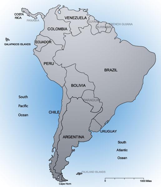
2 The Guianas Countries Guyana, Suriname, French Guyana Culture reflects colonial history Official Languages Guyana English Suriname Dutch French Guyana - French Religions Suriname and Guyana Muslim and Hindu
3
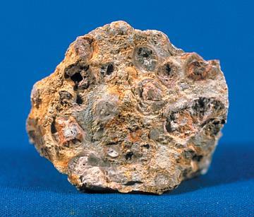
4 The Guianas contd. Effects of Migration Africans were brought to area as slaves Asians migrated to area after slavery ended Suriname has a large mulatto population Economic Activities Fishing is important Farmers grow sugar cane and rice Bauxite is abundant here
5
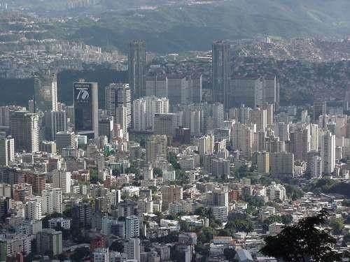
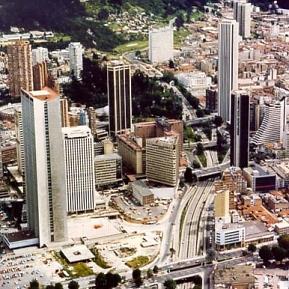
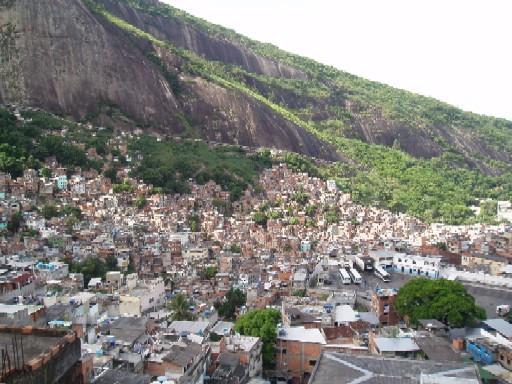
6 Venezuela Population is 24 million Average per capita GNP is $780 South America s poorest country Life Expectancy is 73 years Official Language is Spanish and most residents are Catholic The Andean Highlands Area of plateaus and hills near the Andes Capital of Caracas located here Most of the population live in rachitos or small shacks similar to fevelas
7
 located here Llanos is a savannah region that receives rain only half")
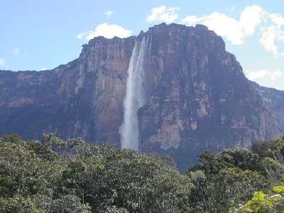
8 Venezuela Contd. Waterfalls and Grasslands Tropical rainforests are found on the border with Brazil World s largest waterfall (Angel Falls) located here Llanos is a savannah region that receives rain only half the year making agriculture difficult Elevation and Climate Elevation effects the vegetation of the region Coffee is grown in the tierra templada region where the climate is mild
9
10 Venezuela contd. An Oil-Rich Region Venezuela is a major producer of oil Oil deposits are found in four areas Eastern Llanos The lowlands near Lake Maracaibo The Orinoco River Delta Offshore
11 Colombia Named after Christopher Columbus Physical Characteristics Has three regions Lowlands, mountains, llanos 75% of the population live in the plateau between the mountains Bogotá is located here A Single Crop Coffee is the only cash-crop grown in Colombia Campesinos (tenant farmers) can barely keep their families fed If coffee prices drop, the country could be in trouble
12
13 Colombia contd. The Drug Trade Marijuana and Cocaine has become a major product of Colombia Small groups of people or families control most of the trade leading to violence US and Colombian governments have tried to stop this problem Cooperation and Conflict Colombia has seen many civil wars since gaining independence from Spain in the 1820s 200,000 people were killed in a civil war in the 1950s Conflict still continues today
14 Brazil s Quest for Economic Growth
15 Economic Challenges Most of Brazil s poor live in favelas Small number of wealthy own plantations Rural workers have to find jobs on plantations or become subsistence farmers The government promised land redistribution that never happened People living in the sertao face high poverty because of the weak soil
16
17
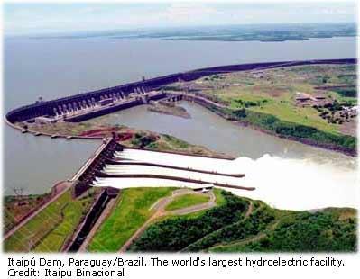
18 Government Policies Brazilian government has tried to boost the growth of industry and encourage development of interior Economic Activities Government built first steel mill and oil refinery in the 1940s It also built hydroelectric plants along the rivers A bank was established to loan money to new business owners Brazil s economy moved from agriculture to industry during the 1950s because of auto, chemical, and steel industries
19
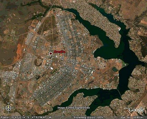
20 Government Policies contd. Patterns of Settlement Brasilia was created to encourage people to move from Rio and Sao Paulo Government built thousands of roads with Brasilia at the center The government gave away plots of land in the north to encourage settlement 1 million people migrated to the Amazon between 1970 and 1985
21
22 Economic Growth Industry makes up 1/3 of Brazil s GNP Gasohol (mix of gasoline and alcohol) helped country respond to high gas prices in the 1970s Ethanol is now made from sugar cane 1/3 of the workforce is in mining, manufacturing, and construction Service industries are also being developed These moves have created an educated workforce and growing middle-class
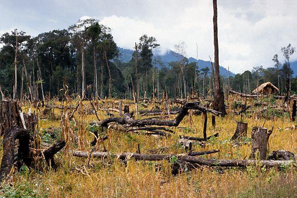
23 Environmental Challenges Economic development has led to more poverty because people can t find jobs Government has tried to create low cost housing to help Challenges and opportunities Farming in the Amazon is difficult Thick vegetation that was cut down led to soil washing away Soil is not very fertile Settlers must clear more land after a growing season
24 Environmental Challenges contd. New Efforts Deforestation is becoming a very serious problem Brazil s military patrols the rain forest to cut down on illegal forestry Taxes encourage people to maintain forest areas Ecotourism allows people to vacation without affecting the ecosystem
25
Brazil. Chapter 12. Chapter 12, Section
 Chapter 12, Section World Geography Chapter 12 Brazil Copyright 2003 by Pearson Education, Inc., publishing as Prentice Hall, Upper Saddle River, NJ. All rights reserved. Chapter 12, Section World Geography
CHAPTER Latin America. Regional Atlas Study Guide. 2 Chapter A. As You Read. B. Reviewing Vocabulary
 CHAPTER 28 9 Many Th ew inventions new Regional Atlas Study Guide Latin America Directions: As you work through the Regional Atlas, complete the chart below by writing two details about each Latin American
Name: Hour: Day: The Land and Its Regions (pg ) Define, in your own words, escarpment. Define, in your own words, sertão
 Define, in your own words, escarpment. Define, in your own words, sertão") Name: Hour: Day: World Geography Guided Reading Notes Chap 12 & 13 --- ANSWER IN COMPLETE SENTENCES!!!! READ EACH QUESTION CAREFULLY & ANSWER COMPLETELY!!!! Objectives: Upon completion of reading you should
Name: Hour: Day: World Geography Guided Reading Notes Chap 12 & 13 --- ANSWER IN COMPLETE SENTENCES!!!! READ EACH QUESTION CAREFULLY & ANSWER COMPLETELY!!!! Objectives: Upon completion of reading you should
Essential Questions. 1. How have historical figures and events affected South America today?
 South America Essential Questions 1. How have historical figures and events affected South America today? 2. How has location affected the development of countries in South America? 3. How has the role
CHAPTER 12. South America. Section 1: Natural Environments Section 2: History and Culture Section 3: South America Today. HOLT World Geography
 CHAPTER 12 South America Section 1: Natural Environments Section 2: History and Culture Section 3: South America 1 Section 1 Natural Environments Objectives: What are the major landforms and rivers of
South America. pg. 520 (5 th) pg. 523 (6 th )
 pg. 523 (6 th )") South America pg. 520 (5 th) pg. 523 (6 th ) Venezuela Rich in Oil Lake Maracaibo Called Little Venice pg. 572 (5 th) pg. 574 (6 th ) Caracas 8 miles Inland 3000 pg. 572 (5 th) pg. 574 (6 th ) Caracas
South America pg. 520 (5 th) pg. 523 (6 th ) Venezuela Rich in Oil Lake Maracaibo Called Little Venice pg. 572 (5 th) pg. 574 (6 th ) Caracas 8 miles Inland 3000 pg. 572 (5 th) pg. 574 (6 th ) Caracas
Geographic Qualities of South America
 Geographic Qualities of South America 1. South America is the fourth largest continent in area. It is located in the Western Hemisphere, lying southwest of North America. Most of South America lies in
6th Grade Western Hemisphere Geography
 6th Grade Western Hemisphere Geography Multiple Choice Identify the choice that best completes the statement or answers the question. 1 Latin America is located in the A Northern Hemisphere. C Western
Latin America and The Caribbean. A Closer Look.
 Latin America and The Caribbean A Closer Look. Mexico Capital: Mexico City The Location of Mexico Mexico is the second-largest country by size and population in Latin America.but the Largest Spanish -
Latin America 11/4/2013. Latin America Today. 580 million people 9% of the world s population Diverse backgrounds:
 Latin America Chapter 10 Human Geography Latin America Today 580 million people 9% of the world s population Diverse backgrounds: Native Americans Europeans Africans Asians 1 Population 393 million live
LOCATION, CLIMATE, AND NATURAL RESOURCES OF MEXICO
 SS6G3 The student will explain the impact of location, climate, distribution of natural resources, and population distribution on Latin America and the Caribbean. a. Compare how the location, climate,
6th Grade Western Hemisphere Geography
 6th Grade Western Hemisphere Geography Multiple Choice Identify the choice that best completes the statement or answers the question. 1 Latin America is located in the A Northern Hemisphere. C Western
WORLD GEOGRAPHY. Hector Rodriguez
 Mr. Chavira 9th Period WORLD GEOGRAPHY Hector Rodriguez P a g e 1 Table of Contents Latin America Page 2 o Maps Economic Map Page 3 Political Map Page 4 Population Map Page 5 Physical Page 6 o Notes Physical
Chapter 19 Test on South America
 Name Part 1 - Labeling (27 pts.) Chapter 19 Test on South America Score A. Locate the countries and territory contained in the word box below on the map of South America on the next page. Write the name
Mrs. Reifsnyder World Geography. Unit 8: Latin America Study Guide SOLs Addressed: WG. 1c, 2b, 3c, 4, 10b/c
 Mrs. Reifsnyder World Geography Unit 8: Latin America Study Guide SOLs Addressed: WG. 1c, 2b, 3c, 4, 10b/c Essential Questions: - In what ways do physical, economic, and cultural characteristics influence
*Latin America spans 7,000 miles, from Mexico to Tierra Del Fuego. *3 Regions: Central America, South America, and the Caribbean.
 Physical Geography Latin America spans 7,000 miles, from Mexico to Tierra Del Fuego *3 Regions: Central America, South America, and the Caribbean. *Intro clip: http://www.youtube.com/watch?v=cffp6rza3
UNIT 3 Extra Review for Chapters 9-11
 UNIT 3 Extra Review for Chapters 9-11 Mexico Central America Caribbean Islands Middle America is Central America, Mexico, and the Islands of the Caribbean Central America is a region within Middle America.
Latin America. Introduction
 Latin America Introduction What are the 5 Themes of Geography? Draw lines to connect the theme to the definition: Location How humans and the environment impact each other Physical and human characteristics
Brazil. Population & Culture
 Brazil Population & Culture Population of Brazil Largest country in South America 200 million people (2012 est) Growing population - approximately 1% per year Life expectancy - approx 72 years Population
Brain Wrinkles. Location, Climate, & Natural Resources of. Where People Live & How They Trade
 Location, Climate, & Natural Resources of Where People Live & How They Trade It s south of the US, east of the Pacific Ocean, and west of the Gulf of Mexico & Caribbean Sea. It s great that it s located
STANDARDS: Brain Wrinkles
 STANDARDS: SS6G3 The student will explain the impact of location, climate, distribution of natural resources, and population distribution on Latin America and the Caribbean. a. Compare how the location,
1st Period Mr. Chavira WORLD GEOGRAPHY. Hector Rodriguez
 1st Period Mr. Chavira WORLD GEOGRAPHY Hector Rodriguez P a g e 1 Table of Contents Latin America Page 2 o Maps Economic Map Page 3 Political Map Page 4 Population Map Page 5 Physical Page 6 o Notes Physical
South American Countries. Capital Location Population Terrain Climate
 South American Countries Capital Location Population Terrain Climate Andes Mountains Four large areas that make up the Central Plains: Llanos, the Selva, the Gran Chaco, and the Pampas Brazilian Highlands
STUDY GUIDE. The Land. Physical Features of Latin America. Chapter 8, Section 1. Terms to Know DRAWING FROM EXPERIENCE ORGANIZING YOUR THOUGHTS
 For use with textbook pages 193 198. The Land Terms to Know cordillera A mountain range that runs parallel to another mountain range (page 194) altiplano A high plain (page 194) escarpment A steep cliff
South America. Land of Color and Contrast
 South America Land of Color and Contrast Home to: *The world s largest river system *The longest mountain chain, and second tallest mountains *Earth s driest desert *One of the world s great grassland
Regional Atlas: Introduction to Latin America
 Chapter 9, Section World Geography Chapter 9 Regional Atlas: Introduction to Latin America Copyright 2003 by Pearson Education, Inc., publishing as Prentice Hall, Upper Saddle River, NJ. All rights reserved.
Comprehension Questions:
 Unit 3: Central & South america Comprehension Questions: 1. What is the driest desert on earth? Atacama Desert 2. What two water routes were discovered in the 1500s to get around the tip of South America?
Chapter 10 Study Guide SOUTH AMERICA
 Chapter 10 Study Guide SOUTH AMERICA When Spain and Portugal competed for trading lands in the New World, who came up with the line of demarcation to settle the dispute? The Caribbean Countries: Who was
Why is the US industry and agriculture prosperous? The US industry and agriculture is so prosperous because it has many different natural resources.
 Ch. 1-7 Study Guide Why is the US industry and agriculture prosperous? The US industry and agriculture is so prosperous because it has many different natural resources. What likely drew immigrants to the
Chapter 21: EAST AFRICA
 Chapter 21: EAST AFRICA Physical Geography of East Africa Landforms East Africa is a diverse landscape of different plains, volcanic mountains, and plateaus cut by a large valley and marked by many rivers
Latin America. Physical Geography
 + Latin America Physical Geography + I. Landforms A. Caribbean & Central America 1. Mexico is dominated by two mountain chains, collectively called the Sierra Madre. A high plateau is situated in between.
A funny sounding lake. South American Landforms, Climate, and Vegetation
 A funny sounding lake South American Landforms, Climate, and Vegetation 3 4 Essential Question: How have physical features and climate affected the population distribution of Latin America? 5 I. Landforms
Latin America. Physical Geography
 Latin America Physical Geography Regions Latin America can be divided into separate regions based on physical geography or cultural geography. Regions If we look at physical geography Latin America has
Latin America s Physical Geography. EQ: What are characteristics of Latin America s physical features?
 Latin America s Physical Geography EQ: What are characteristics of Latin America s physical features? Your Task: We are going to participate in a Museum Walk! You will travel around the room with a partner
LATIN AMERICA. Mexico Central America Caribbean Islands South America
 LATIN AMERICA Mexico Central America Caribbean Islands South America HISTORY First Settlers Hunters/gatherers from Asia crossed land bridge connecting Asia and Alaska Learned to farm over time Maize (corn)
Many ecotourists visit the various natural habitats in Central America. Why do you think ecotourism has become so popular?
 Chapter 9 Middle America and Spanish Speaking South America pg. 252 287 9 1 Central America pg. 255 259 Connecting to Your World What is one country in Central America that promotes ecotourism? Many ecotourists
Latin America. Chapter 9 Physical Geography
 Latin America Chapter 9 Physical Geography Latin American Regions Middle America includes Mexico and the Central American countries The Caribbean Islands South America Mexico Landforms Sierra Madre Oriental
Introduction. We hope you find these materials useful and would welcome any feedback.
 Introduction This planning pack was produced with teachers from County Durham following a visit to São Paulo. The materials support the teaching of geography at key stage one and two within the context
Portuguese Language - Fostering National Unity
 Geography Brazil Brazil Portuguese Language - Fostering National Unity 11 dialects of Portuguese Influenced by Amerindian and African languages, creating differences between Portuguese spoken in Brazil
Economy 3. This region s economy was based on agriculture. 4. This region produced items such as textiles, iron, and ships in great quantities. For th
 Geography 1. This region has a climate of warm summers and snowy cold winters. 2. This region has a climate that is generally warm and sunny, with long, hot, humid summers, and mild winters, and heavy
LOCATION, LOCATION, LOCATION! Mexico, Venezuela, Cuba, and Brazil
 LOCATION, LOCATION, LOCATION! Mexico, Venezuela, Cuba, and Brazil GPS and E.Q. GPS: SS6G3 The student will explain the impact of location, climate, distribution of natural resources, and population distribution
Introduction to Africa
 Introduction to Africa Did you know? Africa has more countries than any other continent. The Sahara is a desert that is the size of the U.S. It s the world's largest desert. Most of the world s gold and
Warm-up. A. Exports only manufactured goods B. Should import fewer products C. Needs to import more products D. Does not import or export
 Warm-up As with any small country, Cuba has fewer natural resources than countries such as Brazil. This affects their trade in that Cuba A. Exports only manufactured goods B. Should import fewer products
Chapter 6: South America
 Chapter 6: South America Identifying the Boundaries Europeans called the Western Hemisphere the New World. South America is the realm consisting of the southern portion of the New World. This realm includes
Geography: Latin America (ch. 8, 9 and 10) page 1. p. 178: What areas make up Latin America? Mexico, Central Amer., Caribbean Islands, South America
 page 1. p. 178: What areas make up Latin America? Mexico, Central Amer., Caribbean Islands, South America") Geography: Latin America (ch. 8, 9 and 10) page 1 p. 178: What areas make up Latin America? Mexico, Central Amer., Caribbean Islands, South America Chapter 8: Physical Geography of Latin America I. The
Geography: Latin America (ch. 8, 9 and 10) page 1 p. 178: What areas make up Latin America? Mexico, Central Amer., Caribbean Islands, South America Chapter 8: Physical Geography of Latin America I. The
Chapter 6 South America
 Chapter 6 South America Identifying the Boundaries Europeans called the Western Hemisphere the New World. South America is the realm consisting of the southern portion of the New World. This realm includes
Physical characteristics and biomes:
 Physical characteristics and biomes: Sahel region, bordering Sahara Characteristics Area suffers from lack of rainfall, over grazing, which causes loss of vegetation and loss of inhabitable areas causing
Mexico. Chapter 10. Chapter 10, Section
 Chapter 10, Section World Geography Chapter 10 Mexico Copyright 2003 by Pearson Education, Inc., publishing as Prentice Hall, Upper Saddle River, NJ. All rights reserved. Chapter 10, Section World Geography
THE PHYSICAL AND CULTURAL GEOGRAPHY OF SOUTH AMERICA
 THE PHYSICAL AND CULTURAL GEOGRAPHY OF SOUTH AMERICA 1 Global location Relative to European capitals Relative to US cities Time zones Two oceans Pacific rim countries - farther to Asia than USA Not on
COUNTRY DATA: BRAZIL: Information from the CIA World Factbook INTRODUCTION
 COUNTRY DATA: BRAZIL: Information from the CIA World Factbook INTRODUCTION Following more than three centuries under Portuguese rule, Brazil gained its independence in 1822, maintaining a monarchical system
Brazil. Brazil A Reading A Z Level J Leveled Book Word Count: 279 LEVELED BOOK J
 Brazil A Reading A Z Level J Leveled Book Word Count: 279 Discussion Questions Evaluate: What is interesting about the Amazon rainforest? Analyze: Why do you think the author calls Brazil an exciting country?
Brazil. Brazil A Reading A Z Level T Leveled Book Word Count: 1,090 LEVELED BOOK T
 Brazil A Reading A Z Level T Leveled Book Word Count: 1,090 Discussion Questions Compare and Contrast: How are the Pantanal and the Amazon Rainforest alike? How are they different? Cause and Effect: In
Exploring Mexico. Directions: Complete the paragraphs below. Write the correct word from the Word Bank to complete each sentence.
 Exploring Mexico Section 1 10 Directions: Complete the paragraphs below. Write the correct word from the Word Bank to complete each sentence. Word Bank United States Central Plateau irrigation isthmus
COUNTRY DATA: Haiti : Information from the CIA World Factbook INTRODUCTION
 COUNTRY DATA: Haiti : Information from the CIA World Factbook INTRODUCTION The native Taino Amerindians - who inhabited the island of Hispaniola when it was discovered by COLUMBUS in 1492 - were virtually
North Africa. Chapter 25. Chapter 25, Section
 Chapter 25, Section World Geography Chapter 25 North Africa Copyright 2003 by Pearson Education, Inc., publishing as Prentice Hall, Upper Saddle River, NJ. All rights reserved. Chapter 25, Section World
THINGS TO REMEMBER CARIBBEAN STUDIES
 PREMIER CURRICULUM SERIES Based on the Sunshine State Standards for Secondary Education, established by the State of Florida, Department of Education THINGS TO REMEMBER CARIBBEAN STUDIES Copyright 2009
Sub - Saharan Africa
 Sub - Saharan Africa 4/14/2015 Countries with Relative Importance GDP South Africa Gabon Botswana Land Size Sudan Chad Mozambique Madagascar Democratic Republic of the Congo (formerly Zaire) Population
4/29/14. Video: Haiti s Indigenous People. Haiti this place just can t seem to get a. https://www.youtube.com/watch? v=pmh53kxkj14 29 minutes
 Video: Haiti s Indigenous People Haiti this place just can t seem to get a break v=pmh53kxkj14 29 minutes Flag of Haiti Where is Haiti? I m the map Pre-Columbus Est. 500,000 Arawaks on the island Generally
Caribbean South America
 8 Caribbean South America Caribbean South America is a region of varied landscapes. The fertile valleys in the Andes and the rich land near the Caribbean shore were important to Spain s empire. My name
LATIN AMERICA. Mexico, Central America and South America
 LATIN AMERICA Mexico, Central America and South America Physical Geography: Plate tectonics pushing together formed what major mountain range?? Andes Mountains Natural disasters the area is prone to:
SS7G1 The student will locate selected features of Africa.
 Standards SS7G1 The student will locate selected features of Africa. a. Locate on a world and regional political-physical map: the Sahara, Sahel, savanna, tropical rain forest, Congo River, Niger River,
The Cultures of South America
 Section 3 Prepare to Read Objectives In this section you will 1. Find out what ethnic groups are represented in the different cultural regions of South America. 2. Learn what life is like in the countryside
Exploring South America Learning Lapbook with Study Guide
 A J T L Grades 1-4 Exploring South America Learning Lapbook with Study Guide A Journey Through Learning www.ajourneythroughlearning.com Copyright 2013 A Journey Through Learning 1 Authors-Paula Winget
Geography of CA and CI
 Geography of CA and CI Caribbean Islands Central America -Central America (CA) is an isthmus connecting North America to South America. It consists of 7 countries. -The Pacific side of CA is covered by
early human history and Central & South America Jeopardy
 early human history and Central & South America Jeopardy Every team will be chosen by Joe with the intention of mixing girls and boys and grade levels. Teams can choose a name if desired. teams can answer
N the northeastern shoulder of the ()
") xii: THE OIJIANAS N the northeastern shoulder of the () continent lies a huge block of territory as large as France and Spain combined. It is in reality an island, since it is bounded on the north and
xii: THE OIJIANAS N the northeastern shoulder of the () continent lies a huge block of territory as large as France and Spain combined. It is in reality an island, since it is bounded on the north and
5. What environmental problems result from the cocaine production process?
 5. What environmental problems result from the cocaine production process? 6. How did colonial activity assist in determining which ethnic group or groups would be at the top or bottom of the socioeconomic
Latin American Revolutions of the early 1800s
 Latin American Revolutions of the early 1800s I. Background The Spanish/Portuguese Colonial System A. The Roles of Colonies fulfillment of mercantilism for Spain and Portugal 1. Plantation Agriculture
Here you will find out how Brazil developed over the centuries and why people travelled to live in the country.
 Here you will find out how Brazil developed over the centuries and why people travelled to live in the country. The people of Brazil are descended from people who came from many other parts of the world.
Chapter 20. The Physical Geography of Africa South of the Sahara
 Chapter 20 The Physical Geography of Africa South of the Sahara Chapter Objectives Identify the major landforms, water systems, and natural resources of Africa south of the Sahara. Describe the relationship
Objective. Students will familiarize themselves with the physical features and climates of Latin America.
 Journal Write KWL What do you KNOW about Latin America? What do you WANT TO KNOW about Latin America? What did you LEARN today that you didn t know before? Latin America Objective Students will familiarize
3 rd Term Worksheet [ ] Subject Geography Class VI Name : Sec. :
![3 rd Term Worksheet [ ] Subject Geography Class VI Name : Sec. :](/thumbs/84/89736232.jpg "3 rd Term Worksheet [ ] Subject Geography Class VI Name : Sec. :") 1 geo (vi) 3 rd Term Worksheet [2018 19] Subject Geography Class VI Name : Sec. : Case Study 1 : The Lumberjacks of Canada Exercise: [80-81] [A] Choose the correct answers: [80] 1. What are the men who
1 geo (vi) 3 rd Term Worksheet [2018 19] Subject Geography Class VI Name : Sec. : Case Study 1 : The Lumberjacks of Canada Exercise: [80-81] [A] Choose the correct answers: [80] 1. What are the men who
Rivers. Highlights of some of the World s Most Famous Rivers!
 Rivers Highlights of some of the World s Most Famous Rivers! Directions This Power Point presentation contains information about some of the most famous rivers in the world! Students should use this presentation
WORLD REGIONAL GEOGRAPHY. By Brett Lucas
 WORLD REGIONAL GEOGRAPHY By Brett Lucas SOUTH AMERICA Part 2 Regions The Caribbean North: Colombia History of Conflict Civil war over religious issues: Catholic conservatives vs. liberals divided
The Lesser Antilles. Dominican Republic), and Puerto Rico
, and Puerto Rico") The Caribbean Islands are archipelagoes or groups of islands. The major archipelagoes are: The Greater Antilles - Cuba, Jamaica, Hispaniola (Composed of Haiti and the Dominican Republic), and Puerto Rico
The Caribbean Islands are archipelagoes or groups of islands. The major archipelagoes are: The Greater Antilles - Cuba, Jamaica, Hispaniola (Composed of Haiti and the Dominican Republic), and Puerto Rico
COUNTRY DATA: Cuba : Information from the CIA World Factbook
 COUNTRY DATA: Cuba : Information from the CIA World Factbook INTRODUCTION The native Amerindian population of Cuba began to decline after the European discovery of the island by Christopher COLUMBUS in
U N I T 3 Latin America
 UN I T 3 Latin America Introducing the Region: Physical and Human Geography Chapter 9 Spatial Inequality in Mexico City: From Cardboard to Castles TCI5 428 GA_SE_ML_03-1.eps Cyan Magenta Yellow Black Second
Activity 1 - Where is Brazil? Using a map or atlas to help you:
 Activity - Where is Brazil? Using a map or atlas to help you: Label all the countries of South America 2 Mark and name the Equator and the Tropic of Capricorn 3 Mark and name the Amazon River, and the
Central America and the Caribbean. The Link Between North and South America
 Central America and the Caribbean The Link Between North and South America Today, the combined population of Central American countries is over 40 million larger than all of Canada. Combined, the 7 nations
Mrs. Davis s Adventures
 Mrs. Davis s Adventures Latin America Countries & Political Map NAME: DATE: PERIOD: DIRECTIONS: Use your mapping skills and textbook pages: 127, 97, and 3 to complete Mrs. Davis s Story. Transfer the countries
CH. 1 Europe and Russia: Physical Geography. Section 1 Land and Water p Europe and Russia are part of the world s largest landmass called.
 CH. 1 Europe and Russia: Physical Geography Section 1 Land and Water p.10-16 Europe and Russia are part of the world s largest landmass called. The country of Russia stretches over both continents. About
OneDollarGlasses Lentes al instante
 OneDollarGlasses Lentes al instante National HI Association Summary Worldwide, more than 150 million people would need a pair of glasses, but cannot afford it. They cannot learn, cannot work and cannot
Warm ups *What was the most valuable natural resource in the development of the Northeast? Why? *What does a megalopolis refer to?
 Warm ups 9.22.2016 *What was the most valuable natural resource in the development of the Northeast? Why? *What does a megalopolis refer to? Lesson Objective: *identify the key natural resources that influenced
The geographic landscape of Brazil varies greatly within the nation. The total area of Brazil is
 Brazil Location, geography, and climate The geographic landscape of Brazil varies greatly within the nation. The total area of Brazil is approximately 8,547,403.5 square kilometers and borders every South
Part 1: Physical Geography
 Part 1: Physical Geography Highlands Lowlands Wide range in elevation creates diverse climate zones in the region A mountain chain stretches along the western edge of the American continents for more
GEOGRAPHY AND HISTORY
 GEOGRAPHY AND HISTORY YEAR 1, PART 1 www.vicensvives.es Contents 01 Our planet Earth 02 The representation of the Earth: maps 03 The Earth s relief 04 Rivers and seas 05 Weather and climate 06 Climates
The Cuban Revolution and Guerrilla Movement in Mexico
 Warm up 1) Who lead Mexico to independence? 2) What as Simon Bolivar's nick name? What countries did Bolivar lead to independence? 3) I was an ex-slave who lead Haiti to independence, Who am I? 4) Which
Andean Competitiveness
 Background 1. Poor countries, high income inequality 2. Failure of ISI brought inflation, deep economic crisis and political crisis in the 70s 3. Market oriented economic reforms in the 80s and 90s 4.
BRAZIL AGRICULTURE TOUR TO THE COOPAVEL SHOW RURAL Coopavel Show Rural in Cascavel
 BRAZIL AGRICULTURE TOUR TO THE COOPAVEL SHOW RURAL Coopavel Show Rural in Cascavel 10 DAYS / 9 NIGHTS See Brazil's largest agricultural show, the Coopavel "Show Rural" in Cascavel, tour Soybean Farms in
6th Grade Third Nine Weeks Benchmark Assessment
 6th Grade Third Nine Weeks Benchmark Assessment Multiple Choice Identify the choice that best completes the statement or answers the question. Key Concepts 1 Latin America is located in the A Northern
Chapter 13 and 14 Geography Study Guide
 Chapter 13 and 14 Geography Study Guide Multiple Choice Identify the letter of the choice that best completes the statement or answers the question. 1. Which West African country has the largest population
Warm ups *What is unique about the status of Switzerland? *How Austria s history differed from that of Switzerland?
 Warm ups 12.07.2016 *What is unique about the status of Switzerland? *How Austria s history differed from that of Switzerland? Lesson Objective: *describe how Spain differs physically, economically, and
Chapter 7 Mexico, Central America, & the Caribbean
 Chapter 7 Mexico, Central America, & the Caribbean Chapter 7, Lesson 1 Physical Geography of Mexico, Central America, & the Caribbean Physical Characteristics of Mexico and Central America An isthmus narrow
Chapter 3. The English Colonies
 Chapter 3 The English Colonies Terms 1. Indentured servants 2. Cash crops 3. Assembly 4. Puritans 5. Mayflower Compact 6. Slave trade 7. Fundamental orders Massachusetts- 1630 Founders- William Bradford
Australian Geography. Standards:
 Australian Geography Standards: SS6G12 The student will be able to locate selected features of Australia. a. Locate on a world and regional political-physical map: the Great Barrier Reef, Coral Sea, Ayers
Mediterranean Europe
 Chapter 17, Section World Geography Chapter 17 Mediterranean Europe Copyright 2003 by Pearson Education, Inc., publishing as Prentice Hall, Upper Saddle River, NJ. All rights reserved. Chapter 17, Section
Friday, November 10, 2017
 Friday, November 10, 2017 Andes and Midlatitude Countries Objective: Summarize the main physical features and regions of the Southern Cone. Identify and locate the urban centers and understand the pattern
4th Grade Social Studies 2nd Nine Weeks Test
 4th Grade Social Studies 2nd Nine Weeks Test Multiple Choice Identify the choice that best completes the statement or answers the question. 1 Which is the largest city in the United States? A Philadelphia,
Unit 9 The Middle East SG 1 - Physical Geography, Population & Demographics
 Unit 9 The Middle East SG 1 - Physical Geography, Population & Demographics I. Physical Geography A. The Middle East includes southwestern Asia and North Africa. 1. The name is Eurocentric. Middle East
Chapter 13: Life in the Central Andes- Adapting to a Mountainous Region
 Chapter 13: Life in the Central Andes- Adapting to a Mountainous Region 1. Introduction La Paz, Bolivia, is the highest big city in the world, sitting at 12,000 feet above sea level in the central Andes