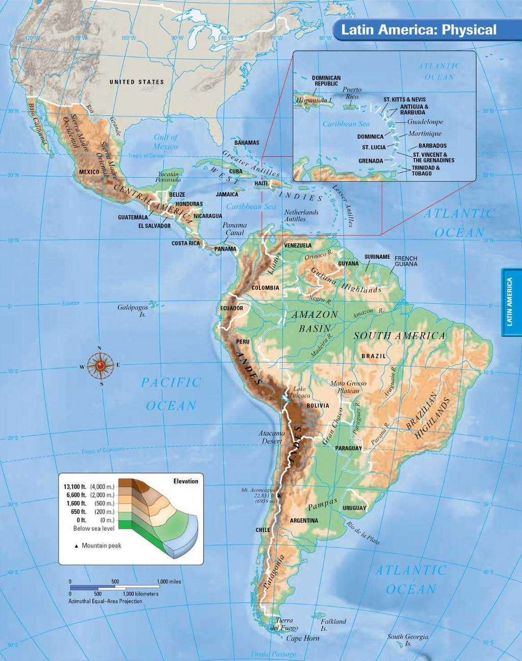
Latin America. Chapter 9 Physical Geography
|
|
|
- Randall Greer
- 6 years ago
- Views:
Transcription
1 Latin America Chapter 9 Physical Geography
2 Latin American Regions Middle America includes Mexico and the Central American countries The Caribbean Islands South America
3

4 Mexico Landforms Sierra Madre Oriental & Occidental Mountains Anáhuac densely populated plateau Oaxaca Plateau, Mexico

5 Sierra Madre Ranges

6 Andes Mountains Longest mountain range in the world Stretches 4,500 miles from north to south, along the west coast of South America Highest peak, Aconcagua, rises 23,000 feet Aconcagua
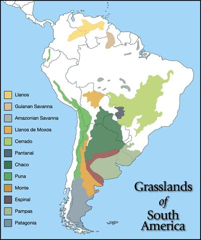
7 Landforms PLAINS Llanos - vast tropical grassland plain situated at the east of the Andes in Colombia & Venezuela (cattle ranching) Pampas - fertile plains in Argentina, Uruguay, & Brazil (grain, cattle, & sheep) PLATEAUS Patagonia cold, windswept plateau in Argentina & Chile Altiplano high plateau in Chile, Argentina, Bolivia & Peru

8 Atacama Desert Located in Chile and Peru Driest desert on Earth Rich deposits of copper and other minerals

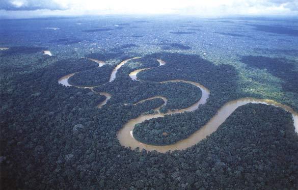
9 Amazon Rainforest South America Covers 1.2 billion acres More than 1/5 of the rainforest has already been destroyed One square kilometer of the Amazon rainforest can contain about 90,000 tons of living plants.


10 Amazon Rainforest The region is home to 2.5 million insect species, tens of thousands of plants, and some 2,000 birds and mammals. Orchid Tapir

11 Amazon River Longest River in the Western Hemisphere Greatest total water flow of any river, carrying more than the Mississippi, Nile, and Yangtze rivers combined Drainage area, called the Amazon Basin, is the largest of any river system Amazon River near Manaus

12 Amazon River

13 Amazon River

14 Amazon River


15 Paraná, Paraguay, & Uruguay 2 nd longest river system in South America Most important commercial highway River System Rio Parana from Encarnacion, Paraguay, looking to Posadas, Argentina

16 Mainly in Venezuela More that 1,500 miles long into the Atlantic Some of the areas drained by the Orinoco are home to the few remaining Native American peoples, such as the Yanomamo Orinoco River

17 Amazon River Dolphin Amazon River Dolphin Found in the Amazon and Orinoco Rivers 1 of 5 freshwater dolphin species in the world Unique pink coloring Also known as Boto
 South America s largest freshwater lake Located in the Altiplano high in the Andes on")
18 Highest commercially navigable lake in the world (12,536 ft. above sea level) South America s largest freshwater lake Located in the Altiplano high in the Andes on the border of Peru and Bolivia Lake Titicaca
19 Lake Maracaibo Located in Venezuela Contains large reserves of crude oil Connected to the Gulf of Venezuela by a narrow strait in the north, making it slightly saline

20 Largest lake in Central America Located in Nicaragua Called The Sweet Sea Has sizeable waves and archipelagos of islands Lake Nicaragua has the only species of freshwater sharks in the whole world. Lake Nicaragua

21 World s highest uninterrupted waterfall at 3,230 feet Located in Venezuela The waterfall was not known to the world until its official discovery in 1933 by the American aviator, James Crawford Angel, on a flight while searching for gold. 16 times the height of Niagara Falls Angel Falls

22 Angel Falls
23 Major Islands Greater Antilles Large islands in the Caribbean Cuba, Jamaica, Hispaniola (Haiti & Dominican Republic), Puerto Rico Lesser Antilles Smaller islands in the region SE of Puerto Rico Divided into the Windward (winds that blow across them) and Leeward (sheltered) Islands

24 Greater Antilles

25 Lesser Antilles
 Copper Tin Iron Lead Nickel Silver")
26 Mineral Resources Bauxite (used to make aluminum) Copper Tin Iron Lead Nickel Silver Gold Bauxite
27 Energy Resources Oil Venezuela & Mexico Coal Natural gas - Trinidad Uranium Hydroelectric power - Brazil

28 Hydroelectric power plant in Brazil

29 9-2 Climate and Vegetation
30 Varied Climate & Vegetation Varied climate and vegetation due to several factors: Spans a great distance on each side of the equator Big changes in elevation because of massive mountains Warms currents of the Atlantic Ocean & the cold currents of the Pacific Ocean affect the climate
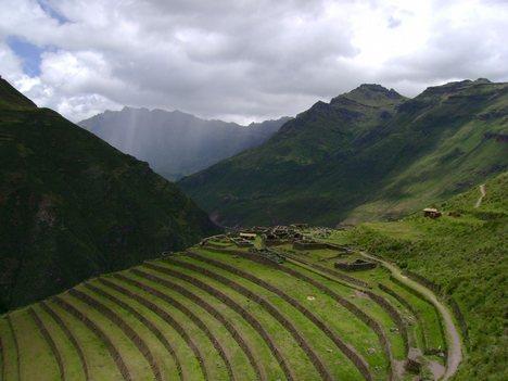
31 Tropical Climate Zones Tropical Wet Rain forests Hot and rainy year round Most of Brazil Tropical Wet & Dry Savannas Hot climates with seasonal rains Found of Brazil, Colombia, & Argentina
32
33 Dry Climate Zones Desert Less than 10 inches of precipitation a year Northern Mexico, coast of Peru, Atacama Desert in Chile, part of Patagonia Semiarid Generally dry, with some rain Parts of Mexico, Brazil, Uruguay, & Argentina
34 Mid-Latitude Climate Zones Humid Subtropical Rainy winters and hot, humid summers Varied vegetation Parts of Paraguay, Uruguay, southern Brazil, southern Bolivia, and northern Argentina Mediterranean Hot, dry summers and cool, moist winters Chapparal vegetation Located in part of Chile Marine West Coast Cool, rainy winters and mild, rainy summers Forests Southern Chile & Argentina Highlands Moderate to cold, depending on elevation Mountains of Mexico & South America

35 Vertical Climate Zones The diagram shows the main climate zones as defined by elevation, with the different plants and animals found in each zone.
36 9-3 Human/Environment Interaction Slash-and-Burn farming Terraced farming Urbanization Tourism
37 Slash-and-Burn Farming - Used by native peoples to clear fields - Cut trees, brush, grasses and burned the debris to clear the field Today, farmers practice this method to clear land for farming in the Amazon River basin Sometimes use destructive farming practices Soil is exhausted after a few years and all nutrients have been drained from the soil Then they move on and clear another spot This is one of the reasons for the shrinking of the rainforest

38 Before & After

39 The aftermath of slash and burn farming in the Amazon.
40 Terraced Farming Ancient technique for growing crops on hillsides or mountain slopes Cut step-like horizontal fields into hillsides and slopes Allow steep land to be cultivated for crops Reduces soil erosion
41
42 Tourism Advantages of Tourism Create jobs Disadvantages of Tourism Congestion Pollution Income gap between tourists and local residents Public debt due to borrowing money to build tourist facilities Often, the owners of the hotels and airlines do not live in the country and the profits go elsewhere
Objective. Students will familiarize themselves with the physical features and climates of Latin America.
 Journal Write KWL What do you KNOW about Latin America? What do you WANT TO KNOW about Latin America? What did you LEARN today that you didn t know before? Latin America Objective Students will familiarize
The Lesser Antilles. Dominican Republic), and Puerto Rico
, and Puerto Rico") The Caribbean Islands are archipelagoes or groups of islands. The major archipelagoes are: The Greater Antilles - Cuba, Jamaica, Hispaniola (Composed of Haiti and the Dominican Republic), and Puerto Rico
The Caribbean Islands are archipelagoes or groups of islands. The major archipelagoes are: The Greater Antilles - Cuba, Jamaica, Hispaniola (Composed of Haiti and the Dominican Republic), and Puerto Rico
Latin America. Physical Geography
 Latin America Physical Geography Regions Latin America can be divided into separate regions based on physical geography or cultural geography. Regions If we look at physical geography Latin America has
STUDY GUIDE. The Land. Physical Features of Latin America. Chapter 8, Section 1. Terms to Know DRAWING FROM EXPERIENCE ORGANIZING YOUR THOUGHTS
 For use with textbook pages 193 198. The Land Terms to Know cordillera A mountain range that runs parallel to another mountain range (page 194) altiplano A high plain (page 194) escarpment A steep cliff
A funny sounding lake. South American Landforms, Climate, and Vegetation
 A funny sounding lake South American Landforms, Climate, and Vegetation 3 4 Essential Question: How have physical features and climate affected the population distribution of Latin America? 5 I. Landforms
Latin America. Physical Geography
 + Latin America Physical Geography + I. Landforms A. Caribbean & Central America 1. Mexico is dominated by two mountain chains, collectively called the Sierra Madre. A high plateau is situated in between.
*Latin America spans 7,000 miles, from Mexico to Tierra Del Fuego. *3 Regions: Central America, South America, and the Caribbean.
 Physical Geography Latin America spans 7,000 miles, from Mexico to Tierra Del Fuego *3 Regions: Central America, South America, and the Caribbean. *Intro clip: http://www.youtube.com/watch?v=cffp6rza3
CHAPTER 12. South America. Section 1: Natural Environments Section 2: History and Culture Section 3: South America Today. HOLT World Geography
 CHAPTER 12 South America Section 1: Natural Environments Section 2: History and Culture Section 3: South America 1 Section 1 Natural Environments Objectives: What are the major landforms and rivers of
Latin America. Introduction
 Latin America Introduction What are the 5 Themes of Geography? Draw lines to connect the theme to the definition: Location How humans and the environment impact each other Physical and human characteristics
Mrs. Reifsnyder World Geography. Unit 8: Latin America Study Guide SOLs Addressed: WG. 1c, 2b, 3c, 4, 10b/c
 Mrs. Reifsnyder World Geography Unit 8: Latin America Study Guide SOLs Addressed: WG. 1c, 2b, 3c, 4, 10b/c Essential Questions: - In what ways do physical, economic, and cultural characteristics influence
Latin America s Physical Geography. EQ: What are characteristics of Latin America s physical features?
 Latin America s Physical Geography EQ: What are characteristics of Latin America s physical features? Your Task: We are going to participate in a Museum Walk! You will travel around the room with a partner
Chapter 19 Test on South America
 Name Part 1 - Labeling (27 pts.) Chapter 19 Test on South America Score A. Locate the countries and territory contained in the word box below on the map of South America on the next page. Write the name
Friday, November 10, 2017
 Friday, November 10, 2017 Andes and Midlatitude Countries Objective: Summarize the main physical features and regions of the Southern Cone. Identify and locate the urban centers and understand the pattern
Essential Questions. 1. How have historical figures and events affected South America today?
 South America Essential Questions 1. How have historical figures and events affected South America today? 2. How has location affected the development of countries in South America? 3. How has the role
Geographic Qualities of South America
 Geographic Qualities of South America 1. South America is the fourth largest continent in area. It is located in the Western Hemisphere, lying southwest of North America. Most of South America lies in
WORLD GEOGRAPHY. Hector Rodriguez
 Mr. Chavira 9th Period WORLD GEOGRAPHY Hector Rodriguez P a g e 1 Table of Contents Latin America Page 2 o Maps Economic Map Page 3 Political Map Page 4 Population Map Page 5 Physical Page 6 o Notes Physical
Brain Wrinkles. Location, Climate, & Natural Resources of. Where People Live & How They Trade
 Location, Climate, & Natural Resources of Where People Live & How They Trade It s south of the US, east of the Pacific Ocean, and west of the Gulf of Mexico & Caribbean Sea. It s great that it s located
South American Countries. Capital Location Population Terrain Climate
 South American Countries Capital Location Population Terrain Climate Andes Mountains Four large areas that make up the Central Plains: Llanos, the Selva, the Gran Chaco, and the Pampas Brazilian Highlands
LOCATION, CLIMATE, AND NATURAL RESOURCES OF MEXICO
 SS6G3 The student will explain the impact of location, climate, distribution of natural resources, and population distribution on Latin America and the Caribbean. a. Compare how the location, climate,
STANDARDS: Brain Wrinkles
 STANDARDS: SS6G3 The student will explain the impact of location, climate, distribution of natural resources, and population distribution on Latin America and the Caribbean. a. Compare how the location,
Comprehension Questions:
 Unit 3: Central & South america Comprehension Questions: 1. What is the driest desert on earth? Atacama Desert 2. What two water routes were discovered in the 1500s to get around the tip of South America?
Latin America and The Caribbean. A Closer Look.
 Latin America and The Caribbean A Closer Look. Mexico Capital: Mexico City The Location of Mexico Mexico is the second-largest country by size and population in Latin America.but the Largest Spanish -
1st Period Mr. Chavira WORLD GEOGRAPHY. Hector Rodriguez
 1st Period Mr. Chavira WORLD GEOGRAPHY Hector Rodriguez P a g e 1 Table of Contents Latin America Page 2 o Maps Economic Map Page 3 Political Map Page 4 Population Map Page 5 Physical Page 6 o Notes Physical
Chapter 20. The Physical Geography of Africa South of the Sahara
 Chapter 20 The Physical Geography of Africa South of the Sahara Chapter Objectives Identify the major landforms, water systems, and natural resources of Africa south of the Sahara. Describe the relationship
Regional Atlas: Introduction to Latin America
 Chapter 9, Section World Geography Chapter 9 Regional Atlas: Introduction to Latin America Copyright 2003 by Pearson Education, Inc., publishing as Prentice Hall, Upper Saddle River, NJ. All rights reserved.
UNIT 3 Extra Review for Chapters 9-11
 UNIT 3 Extra Review for Chapters 9-11 Mexico Central America Caribbean Islands Middle America is Central America, Mexico, and the Islands of the Caribbean Central America is a region within Middle America.
THE PHYSICAL AND CULTURAL GEOGRAPHY OF SOUTH AMERICA
 THE PHYSICAL AND CULTURAL GEOGRAPHY OF SOUTH AMERICA 1 Global location Relative to European capitals Relative to US cities Time zones Two oceans Pacific rim countries - farther to Asia than USA Not on
Portuguese Language - Fostering National Unity
 Geography Brazil Brazil Portuguese Language - Fostering National Unity 11 dialects of Portuguese Influenced by Amerindian and African languages, creating differences between Portuguese spoken in Brazil
South America. Land of Color and Contrast
 South America Land of Color and Contrast Home to: *The world s largest river system *The longest mountain chain, and second tallest mountains *Earth s driest desert *One of the world s great grassland
South America. pg. 520 (5 th) pg. 523 (6 th )
 pg. 523 (6 th )") South America pg. 520 (5 th) pg. 523 (6 th ) Venezuela Rich in Oil Lake Maracaibo Called Little Venice pg. 572 (5 th) pg. 574 (6 th ) Caracas 8 miles Inland 3000 pg. 572 (5 th) pg. 574 (6 th ) Caracas
South America pg. 520 (5 th) pg. 523 (6 th ) Venezuela Rich in Oil Lake Maracaibo Called Little Venice pg. 572 (5 th) pg. 574 (6 th ) Caracas 8 miles Inland 3000 pg. 572 (5 th) pg. 574 (6 th ) Caracas
South America: Physical Geography
 This website would like to remind you: Your browser (Apple Safari 4) is out of date. Update your browser for more security, comfort and the best experience on this site. Encyclopedic Entry South America:
Exploring South America Learning Lapbook with Study Guide
 A J T L Grades 1-4 Exploring South America Learning Lapbook with Study Guide A Journey Through Learning www.ajourneythroughlearning.com Copyright 2013 A Journey Through Learning 1 Authors-Paula Winget
World Geography Ch. 7.2 Climate Regions of Latin America
 World Geography Ch. 7.2 Climate Regions of Latin America BR: D10 When you think of Latin America, what types of climates do you think are down there? Write down which of the following you believe are there:
LOCATION, LOCATION, LOCATION! Mexico, Venezuela, Cuba, and Brazil
 LOCATION, LOCATION, LOCATION! Mexico, Venezuela, Cuba, and Brazil GPS and E.Q. GPS: SS6G3 The student will explain the impact of location, climate, distribution of natural resources, and population distribution
LAST TIME (Happy 300 th Birthday Ben Franklin!)
") LAST TIME (Happy 300 th Birthday Ben Franklin!) Latin American Diversity: Introduction Physical Geography of Mexico, Caribbean, and Central America: 1. Mexican drylands 2. Mesoamerican Highlands 3. Coastal
LAST TIME (Happy 300 th Birthday Ben Franklin!) Latin American Diversity: Introduction Physical Geography of Mexico, Caribbean, and Central America: 1. Mexican drylands 2. Mesoamerican Highlands 3. Coastal
Mrs. Davis s Adventures
 Mrs. Davis s Adventures Latin America Countries & Political Map NAME: DATE: PERIOD: DIRECTIONS: Use your mapping skills and textbook pages: 127, 97, and 3 to complete Mrs. Davis s Story. Transfer the countries
Many ecotourists visit the various natural habitats in Central America. Why do you think ecotourism has become so popular?
 Chapter 9 Middle America and Spanish Speaking South America pg. 252 287 9 1 Central America pg. 255 259 Connecting to Your World What is one country in Central America that promotes ecotourism? Many ecotourists
STUDY GUIDE. The Land. Chapter 20, Section 1. The Land of Africa South of the Sahara. Landforms Water Systems Natural Resources.
 For use with textbook pages 499 504. The Land Terms to Know escarpment A steep, often jagged slope or cliff (page 500) cataract A towering waterfall (page 500) rift valley A large crack in the earth s
2.1 What is the climate like?
 José Medeiros This fact sheet allows you to see how varied the countryside is across Brazil. 2.1 What is the climate like? Most of Brazil is in the Southern Hemisphere, where the seasons are the opposite
Introduction to Africa
 Introduction to Africa Did you know? Africa has more countries than any other continent. The Sahara is a desert that is the size of the U.S. It s the world's largest desert. Most of the world s gold and
6th Grade Western Hemisphere Geography
 6th Grade Western Hemisphere Geography Multiple Choice Identify the choice that best completes the statement or answers the question. 1 Latin America is located in the A Northern Hemisphere. C Western
U N I T 3 Latin America
 UN I T 3 Latin America Introducing the Region: Physical and Human Geography Chapter 9 Spatial Inequality in Mexico City: From Cardboard to Castles TCI5 428 GA_SE_ML_03-1.eps Cyan Magenta Yellow Black Second
UNIT 5 AFRICA PHYSICAL GEOGRAPHY SG 1 - PART II
 UNIT 5 AFRICA PHYSICAL GEOGRAPHY SG 1 - PART II III. CLIMATE & VEGETATION A. The four main climate zones are tropical wet, tropical wet/dry (split into monsoon & savanna), semiarid, and arid. Other climate
Latin America 11/4/2013. Latin America Today. 580 million people 9% of the world s population Diverse backgrounds:
 Latin America Chapter 10 Human Geography Latin America Today 580 million people 9% of the world s population Diverse backgrounds: Native Americans Europeans Africans Asians 1 Population 393 million live
Chapter Objectives. Describe the dominant landforms and natural resources of Southeast Asia. Discuss Southeast Asia s climate and vegetation.
 Chapter Objectives Describe the dominant landforms and natural resources of Southeast Asia. Discuss Southeast Asia s climate and vegetation. The Land Section 1 Objectives Describe how tectonic plates and
Do Not Write On This Sheet. World Rally. City, country, continient: to city, country, continent:
 World Rally At each checkpoint you must list the city, country, and continent. The teacher must check all answers before you can go on to the next checkpoint. Checkpoint 1: Start at: 29 N 98 W and go to:
Latin America: Physical Geography
 Page 1 of 7 Latin America: Physical Geography TERMS & NAMES tributary deforestation Tropical Zone El Niño MAIN IDEA Latin America s landforms, bodies of water, and climate offer a wide range of environments
CHAPTER Latin America. Regional Atlas Study Guide. 2 Chapter A. As You Read. B. Reviewing Vocabulary
 CHAPTER 28 9 Many Th ew inventions new Regional Atlas Study Guide Latin America Directions: As you work through the Regional Atlas, complete the chart below by writing two details about each Latin American
Chapter 10 Study Guide SOUTH AMERICA
 Chapter 10 Study Guide SOUTH AMERICA When Spain and Portugal competed for trading lands in the New World, who came up with the line of demarcation to settle the dispute? The Caribbean Countries: Who was
Rivers. Highlights of some of the World s Most Famous Rivers!
 Rivers Highlights of some of the World s Most Famous Rivers! Directions This Power Point presentation contains information about some of the most famous rivers in the world! Students should use this presentation
Why is the US industry and agriculture prosperous? The US industry and agriculture is so prosperous because it has many different natural resources.
 Ch. 1-7 Study Guide Why is the US industry and agriculture prosperous? The US industry and agriculture is so prosperous because it has many different natural resources. What likely drew immigrants to the
Fieldwork Dates AmericasBarometer
 Fieldwork Dates AmericasBarometer 2004-2014 This document contains information regarding fieldwork s for the AmericasBarometer project, 2004-2014. Some information may be incomplete and we will up the
Location, Climate, & Natural Resources
 Location, Climate, & Natural Resources UK is a country of islands off the coast of mainland Europe. It consists of England, Northern Ireland, Scotland, & Wales. UK s location makes it a HUB for trade.
Location, Climate, & Natural Resources Brain Wrinkles
 Location, Climate, & Natural Resources Standards SS6G10 The student will explain the impact of location, climate, natural resources, and population distribution on Europe. a. Compare how the location,
Just how big is Africa?
 The United States China India The United Kingdom Portugal Spain France Belgium Germany The Netherlands Switzerland Italy Eastern Europe Japan 11.7 million sq. miles Just how big is Africa? Chapter 18 Section
Brazil Today The Amazon River and Basin
 Non-fiction: Brazil Today The Amazon River and Basin Brazil Today The Amazon River and Basin Deep within the Andes Mountains of northern Peru, two rivers flow together. Their junction forms one of the
The Land Photo Source: The Atlas of Canada, The Red River, Manatoba, Canada land/physio_red_ri
 The Land The United States and Canada An Overview of the Region The United States and Canada are the two largest countries in North America. The Rio Grande is part of the southwest border of the United
Name: Hour: Day: The Land and Its Regions (pg ) Define, in your own words, escarpment. Define, in your own words, sertão
 Define, in your own words, escarpment. Define, in your own words, sertão") Name: Hour: Day: World Geography Guided Reading Notes Chap 12 & 13 --- ANSWER IN COMPLETE SENTENCES!!!! READ EACH QUESTION CAREFULLY & ANSWER COMPLETELY!!!! Objectives: Upon completion of reading you should
Name: Hour: Day: World Geography Guided Reading Notes Chap 12 & 13 --- ANSWER IN COMPLETE SENTENCES!!!! READ EACH QUESTION CAREFULLY & ANSWER COMPLETELY!!!! Objectives: Upon completion of reading you should
2015 Brain Wrinkles. SS8G1b
 SS8G1b Georgia is a geographically diverse state that is divided into five regions. The first three regions (Appalachian Plateau, Valley and Ridge, and Blue Ridge) are in the mountains and foothills of
What Is An Ecoregion?
 Ecoregions of Texas What Is An Ecoregion? Ecoregion a major ecosystem with distinctive geography, characteristic plants and animals, and ecosystems that receives uniform solar radiation and moisture Sometimes
CH. 1 Europe and Russia: Physical Geography. Section 1 Land and Water p Europe and Russia are part of the world s largest landmass called.
 CH. 1 Europe and Russia: Physical Geography Section 1 Land and Water p.10-16 Europe and Russia are part of the world s largest landmass called. The country of Russia stretches over both continents. About
6th Grade Western Hemisphere Geography
 6th Grade Western Hemisphere Geography Multiple Choice Identify the choice that best completes the statement or answers the question. 1 Latin America is located in the A Northern Hemisphere. C Western
The Northern Tropics
 The Northern Tropics The Guianas Countries Guyana, Suriname, French Guyana Culture reflects colonial history Official Languages Guyana English Suriname Dutch French Guyana - French Religions Suriname and
Chapter 14. The Physical Geography of Russia
 Chapter 14 The Physical Geography of Russia Chapter Objectives Identify the physical features and natural resources of Russia. Discuss the effects of Russia s climate and vegetation on life in the region.
STUDY GUIDE. The Land. Chapter 29, Section 1. Both. Terms to Know DRAWING FROM EXPERIENCE ORGANIZING YOUR THOUGHTS
 Chapter 29, Section 1 For use with textbook pages 719 724. The Land Terms to Know cordilleras Parallel mountain ranges and plateaus (page 719) archipelago A group of islands (page 720) insular Relating
The Geological Pacific Northwest. Wednesday February 6, 2012 Pacific Northwest History Mr. Rice
 The Geological Pacific Northwest Wednesday February 6, 2012 Pacific Northwest History Mr. Rice 1 Free Response #2 Please do not simply list the items for this response. Full sentences!!! Minimum of 3-5
LATIN AMERICA. Mexico Central America Caribbean Islands South America
 LATIN AMERICA Mexico Central America Caribbean Islands South America HISTORY First Settlers Hunters/gatherers from Asia crossed land bridge connecting Asia and Alaska Learned to farm over time Maize (corn)
Brain Wrinkles. Africa: The impact of location, climate, & physical characteristics on where people live, the type of work they do, & how they travel
 Africa: The impact of location, climate, & physical characteristics on where people live, the type of work they do, & how they travel STANDARDS: SS7G3 The student will explain the impact of location, climate,
Unit 5/Chapter 8 ticket Central America and the Caribbean
 Unit 5/Chapter 8 ticket Central America and the Caribbean Important Vocabulary Latifundia inifundia ISTHMUS : a strip of land two large strips of land ARCHIPELAGO : a or of islands BIODIVERSITY : an as
GEOGRAPHY OF THE WESTERN HEMISPHERE
 GEOGRAPHY OF THE WESTERN HEMISPHERE LEARNING LOG Write clear directions that describe how to get from one place to another. Choose 2 locations that other people might not know about. Did you use a map
early human history and Central & South America Jeopardy
 early human history and Central & South America Jeopardy Every team will be chosen by Joe with the intention of mixing girls and boys and grade levels. Teams can choose a name if desired. teams can answer
Region 1 Piney Woods
 Region 1 Piney Woods Piney Woods 1. This ecoregion is found in East Texas. 2. Climate: average annual rainfall of 36 to 50 inches is fairly uniformly distributed throughout the year, and humidity and temperatures
Terms to Know. artesian well coral atoll krill lagoon
 Chapter Objectives Describe the diverse landforms and natural resources of Australia, Oceania, and Antarctica. Discuss the wide range of climates and vegetation throughout the region. The Land Section
Geography: Latin America (ch. 8, 9 and 10) page 1. p. 178: What areas make up Latin America? Mexico, Central Amer., Caribbean Islands, South America
 page 1. p. 178: What areas make up Latin America? Mexico, Central Amer., Caribbean Islands, South America") Geography: Latin America (ch. 8, 9 and 10) page 1 p. 178: What areas make up Latin America? Mexico, Central Amer., Caribbean Islands, South America Chapter 8: Physical Geography of Latin America I. The
Geography: Latin America (ch. 8, 9 and 10) page 1 p. 178: What areas make up Latin America? Mexico, Central Amer., Caribbean Islands, South America Chapter 8: Physical Geography of Latin America I. The
GEOGRAPHY AND HISTORY
 GEOGRAPHY AND HISTORY YEAR 1, PART 1 www.vicensvives.es Contents 01 Our planet Earth 02 The representation of the Earth: maps 03 The Earth s relief 04 Rivers and seas 05 Weather and climate 06 Climates
Table of Contents. Argentina Brazil Chile Cuba Nicaragua Panama Peru In Your Classroom...
 Table of Contents Argentina... 4 Brazil... 25 Chile... 48 Cuba... 68 Nicaragua... 89 Panama... 109 Peru... 127 In Your Classroom... 148 Answer Key... 152 Additional Resources... 155 MP5129 3 Mts. Argentina
Part 1: Physical Geography
 Part 1: Physical Geography Highlands Lowlands Wide range in elevation creates diverse climate zones in the region A mountain chain stretches along the western edge of the American continents for more
3 rd Term Worksheet [ ] Subject Geography Class VI Name : Sec. :
![3 rd Term Worksheet [ ] Subject Geography Class VI Name : Sec. :](/thumbs/84/89736232.jpg "3 rd Term Worksheet [ ] Subject Geography Class VI Name : Sec. :") 1 geo (vi) 3 rd Term Worksheet [2018 19] Subject Geography Class VI Name : Sec. : Case Study 1 : The Lumberjacks of Canada Exercise: [80-81] [A] Choose the correct answers: [80] 1. What are the men who
1 geo (vi) 3 rd Term Worksheet [2018 19] Subject Geography Class VI Name : Sec. : Case Study 1 : The Lumberjacks of Canada Exercise: [80-81] [A] Choose the correct answers: [80] 1. What are the men who
Unit 1: Physical Geography Notes
 - How has the physical world impacted settlement patterns? o Major factors in the decision-making process of o Before the boom controlling the physical environment was not possible on a large scale - Physical
Monday, December 11, 2017
 Monday, December 11, 2017 Physical Geography of Russia Objective: complete Warm-Up, write outline notes and discuss the geography of Eastern Europe/mother Russia and view Geography Now: Belarus. География
CARIBBEAN ISLANDS 260,671 km 2
 The Bahamas Havana Cuba Camaguey Santiago de Cuba Dominican Republic Santiago Port-au-Prince San Juan Mexico Jamaica Kingston Haiti Santo Domingo Puerto Rico Venezuela CARIBBEAN ISLANDS 260,671 km 2 BIODIVERSITY
Sugar Cane production in both Haiti and the DR are down. New markets could restore production to historic levels.
 Sugar Cane production in both Haiti and the DR are down. New markets could restore production to historic levels. Sugar Cane Production in Haiti and the DR Dominican Republic 25 Haiti 2 15 1 Hectares Harvested
SS7G1 The student will locate selected features of Africa.
 Standards SS7G1 The student will locate selected features of Africa. a. Locate on a world and regional political-physical map: the Sahara, Sahel, savanna, tropical rain forest, Congo River, Niger River,
Oceania. Australia, New Zealand, and the Pacific Islands. Physical Geography. Where is Australia located?
 Oceania Australia, New Zealand, and the Pacific Islands Physical Geography Australia New Zealand Oceania Where is Australia located? Australia & Oceania are a group of islands located between Asia, Antarctica,
SS8G1 The student will describe Georgia with regard to physical features and location.
 SS8G1ab Standards SS8G1 The student will describe Georgia with regard to physical features and location. a. Locate Georgia in relation to the region, nation, continent, and hemispheres. b. Describe the
6th Grade Third Nine Weeks Benchmark Assessment
 6th Grade Third Nine Weeks Benchmark Assessment Multiple Choice Identify the choice that best completes the statement or answers the question. Key Concepts 1 Latin America is located in the A Northern
PHYSICAL GEOGRAPHY. Unit 1
 PHYSICAL GEOGRAPHY Unit 1 HOW HAS THE PHYSICAL WORLD IMPACTED SETTLEMENT PATTERNS? Major factor in the decision-making process of settlers Before the technological boom controlling the physical environment
UNIT 5 PHYSICAL GEOGRAPHY SG 1 - PART I
 UNIT 5 PHYSICAL GEOGRAPHY SG 1 - PART I Africa is HUGE! I. LANDFORMS A. Plateaus - an area of relatively level high ground. 1. Africa s interior is dominated by series of plateaus and elevated basins such
2. The most important crop in Mexico. 3. The Priest who spoke against Spain. 5. Ancient Aztec city, now Mexico City
 Name: Date: Did you hear about what happened at the laundromat last night? Three clothespins held up two shirts! Clues are listed below. Print the word that matches the clue on the blank line by the clue.
1 What do you know about Brazil? What. 2 What would you like to know about Brazil? 3 Look at the short movie clips below to see
 This fact sheet introduces you to the beautiful country of Brazil with its varied scenery. 1 What do you know about Brazil? What is Brazil famous for? Make a list of the facts that you know about the country
Chapter 7 Geography and the Early Settlement of Egypt, Kush, and Canaan
 Chapter 7 Geography and the Early Settlement of Egypt, Kush, and Canaan How did geography affect early settlement in Egypt, Kush, and Canaan? Section 7.1 - Introduction RF/NASA//Corbis This satellite photograph
Chapter 7: Vocabulary (Use the Glossary in the back of your textbook) Chapter 7: Places (Use the Gazetteer in the back of your textbook)
 Chapter 7: Places (Use the Gazetteer in the back of your textbook)") Name Period Chapter 7 Study Guide Chapter 7: Vocabulary (Use the Glossary in the back of your textbook) Review 10-15 min. EVERY Night p. 188 archipelago: p. 188 biome: p. 199 quipu: p. 188 scrub land:
Name Period Chapter 7 Study Guide Chapter 7: Vocabulary (Use the Glossary in the back of your textbook) Review 10-15 min. EVERY Night p. 188 archipelago: p. 188 biome: p. 199 quipu: p. 188 scrub land:
Introduction. We hope you find these materials useful and would welcome any feedback.
 Introduction This planning pack was produced with teachers from County Durham following a visit to São Paulo. The materials support the teaching of geography at key stage one and two within the context
ANDEX: A Regional Hydrology Program for the Andes
 ANDEX: A Regional Hydrology Program for the Andes Silvina Solman CIMA (CONICET-UBA) - Universidad de Buenos Aires Argentina Germán Poveda Universidad Nacional de Colombia, Medellín Colombia TPE-GHP/GEWEX
EXPLORING BIOMES IN GORONGOSA NATIONAL PARK
 EXPLORING BIOMES IN GORONGOSA NATIONAL PARK ABOUT THIS WORKSHEET This worksheet complements the Click and Learn Gorongosa National Park Interactive Map (http://www.hhmi.org/biointeractive/gorongosa-national-park-interactive-map),
AFRICAN PHYSICAL GEOGRAPHY
 AFRICAN PHYSICAL GEOGRAPHY Here are some factoids about Africa: world s second largest continent (11,700,000 miles). Home to 52 countries, 1,000 languages, 800 million people. 10% of the world s population
Countries Of The World: Mexico
 Countries Of The World: Mexico By National Geographic Kids, adapted by Newsela staff on 06.07.18 Word Count 659 Level MAX Image 1: The pyramids of Guachimontones in Jalisco, Mexico. Mexico is a country
Unit 5: Latin America Today
 Unit 5: Latin America Today In this unit, you will turn your attention to Latin America. You will study the geography of some Latin American countries. You will learn about their history, politics, revolutions,
Chapter 21: EAST AFRICA
 Chapter 21: EAST AFRICA Physical Geography of East Africa Landforms East Africa is a diverse landscape of different plains, volcanic mountains, and plateaus cut by a large valley and marked by many rivers
Water in the Amazon. By Heather and Georgie
 Water in the Amazon By Heather and Georgie The Amazon is the world s largest tropical rainforest. The Amazon is so big that the U.K and Ireland would fit into it 17 times. The Amazon River It s length