The Lesser Antilles. Dominican Republic), and Puerto Rico
|
|
|
- Christal Doris Morgan
- 5 years ago
- Views:
Transcription


1

2 The Caribbean Islands are archipelagoes or groups of islands. The major archipelagoes are: The Greater Antilles - Cuba, Jamaica, Hispaniola (Composed of Haiti and the Dominican Republic), and Puerto Rico The Lesser Antilles


3 The Andes Mountains extend from Columbia to the southern tip of Chile and they are over 4,000 miles long. At some points the Andes are over 300 miles wide and large portions of Peru, Ecuador, Chile, and Bolivia have very high elevations.

4


5 Where the Andes are widest there are high flat plains called altiplanos. People live and farm in these areas but the temperature is cool all year long and it can be difficult to grow food.

6


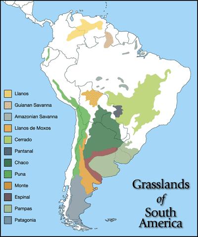
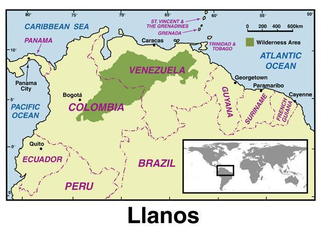
7 Tropical rainforest Pampas - Temperate grassland located in Argentina. Llanos - Tropical grassland located in Colombia and Venezuela. Cerrados - Tropical grasslands located in Brazil.
8
9

10 The Sierra Madre Oriental and Occidentals run along the east and west coast of Mexico. Between these two mountain ranges lie the Mexican Plateau.

11 The Amazon River flows near 4,000 miles from the Andes to the Atlantic Ocean. No other river carries as much water to the ocean.


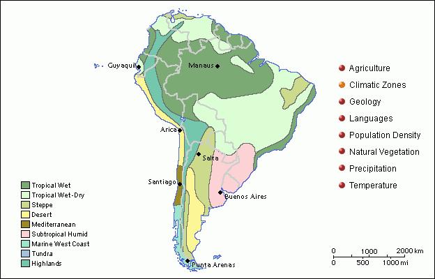
12 The Amazon River is located in South America and it drains a large area that is known as the Amazon Basin. The Amazon has many tributaries, which are smaller rivers that flow into a larger river. Much of the Amazon River is navigable, which means large boats can travel up it to transport goods to the cities located along its banks.

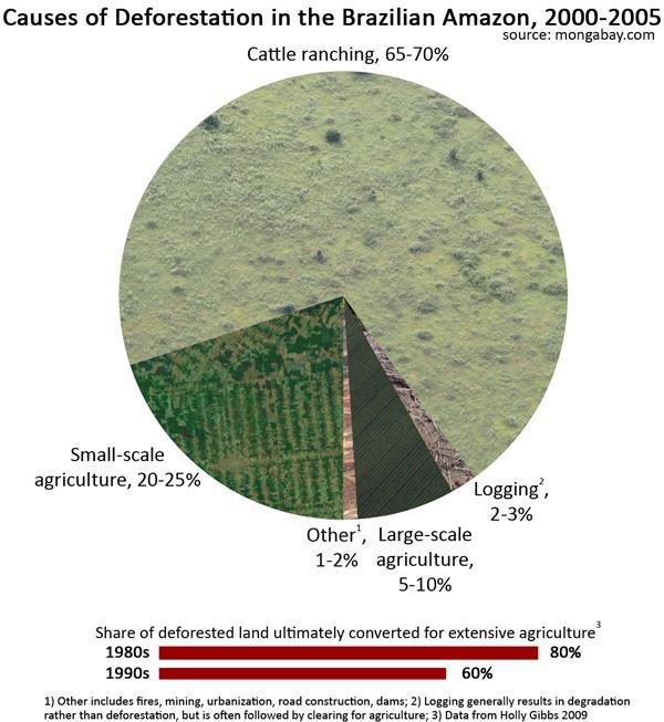
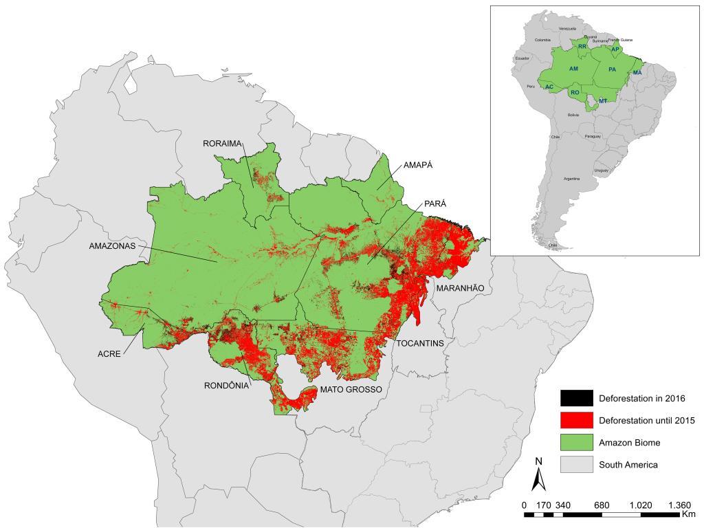
13 Deforestation is the process of cutting and clearing away trees from a forest. This increases the amount of CO2 in the air. Some believe this contributes to global warming.

14


15 The Atacama Desert is located between the Pacific Ocean and the Andes Mountains in northern Chile. It is the driest region in the world.


16 The Atacama Desert is created by orographic precipitation, which is caused by mountains. The Andes Mountains block rain clouds and create a rain shadow.


17 is a region in southern Chile and southern Argentina between the Andes Mountains and the Atlantic Ocean. It is made up of dry plains and plateaus.

18 Located on the Isthmus of Panama, the Panama Canal links the Atlantic and Pacific The Panama Canal is an important waterway that cuts through the isthmus of Panama. The canal is human made and was completed in The canal eliminated the long trip around Cape Horn, the southernmost tip of South America

19 Most of Latin America is in the low latitudes. The two predominant climate zones in Latin America are: Tropical Wet Tropical Wet and Dry

20 The equator runs through Ecuador and Brazil. The area near the equator is known as the low latitudes and is warm all year. The seasons in South America are reversed from our seasons because they are in the Southern Hemisphere. When it is winter in Georgia it is summer in Argentina.


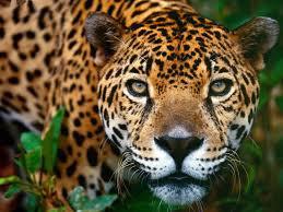
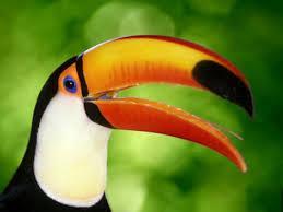
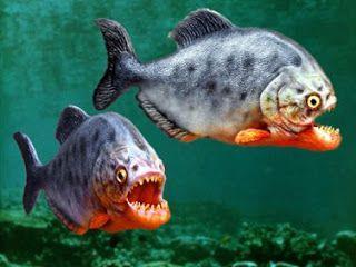
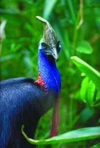
21 The Tropical Zone is located between north and south. This is the area between the Tropic of Cancer and Tropic of Capricorn.


22 A natural weather condition that causes heavy rain and flooding during the Christmas time of year. El Nino is a variation in the ocean & atmospheric temperatures in the Pacific. When the ocean temperature increases it causes ocean currents to reverse direction and can impact the weather in Latin America in many different ways

23

24 Rainforests are located between the Tropic of Cancer and the Tropic of Capricorn. This area is called the "tropics". The tropics is the 3,000 mile wide band around the equator.

25


26 The Amazon is the worlds largest tropical rainforest covering 2.3 million miles. 65% of the Amazon is a jungle. 35% of the Amazon is made up of grassland.

27 The Amazon Rainforest gets nine feet of rain every year (rains almost everyday). 20% of the earth's oxygen is produced by the Amazon Rainforest. The Amazon Rainforest is also known as the "Lungs of our Planet."


28 The Amazon is home to 14,712 different species of animals. Over 60,000 different plants are native to the Amazon. 4,000 types of trees are grown in the rainforest.


29 The rain forest provide food, water, natural rubber, medicinal plants, and other products. Problems Soil exhaustion (soil has lost the nutrients) Deforestation


30

31 Emergents: Top layer. It houses most of the birds and insects. Canopy: Home to many different types of birds, insects, reptiles, mammals, and more. Under story: A cool environment under the leaves which is where you can find many animals. Forest floor: Many animals live here. It is ground level.
32
Latin America. Physical Geography
 Latin America Physical Geography Regions Latin America can be divided into separate regions based on physical geography or cultural geography. Regions If we look at physical geography Latin America has
Latin America. Chapter 9 Physical Geography
 Latin America Chapter 9 Physical Geography Latin American Regions Middle America includes Mexico and the Central American countries The Caribbean Islands South America Mexico Landforms Sierra Madre Oriental
Latin America s Physical Geography. EQ: What are characteristics of Latin America s physical features?
 Latin America s Physical Geography EQ: What are characteristics of Latin America s physical features? Your Task: We are going to participate in a Museum Walk! You will travel around the room with a partner
Objective. Students will familiarize themselves with the physical features and climates of Latin America.
 Journal Write KWL What do you KNOW about Latin America? What do you WANT TO KNOW about Latin America? What did you LEARN today that you didn t know before? Latin America Objective Students will familiarize
A funny sounding lake. South American Landforms, Climate, and Vegetation
 A funny sounding lake South American Landforms, Climate, and Vegetation 3 4 Essential Question: How have physical features and climate affected the population distribution of Latin America? 5 I. Landforms
Mrs. Reifsnyder World Geography. Unit 8: Latin America Study Guide SOLs Addressed: WG. 1c, 2b, 3c, 4, 10b/c
 Mrs. Reifsnyder World Geography Unit 8: Latin America Study Guide SOLs Addressed: WG. 1c, 2b, 3c, 4, 10b/c Essential Questions: - In what ways do physical, economic, and cultural characteristics influence
WORLD GEOGRAPHY. Hector Rodriguez
 Mr. Chavira 9th Period WORLD GEOGRAPHY Hector Rodriguez P a g e 1 Table of Contents Latin America Page 2 o Maps Economic Map Page 3 Political Map Page 4 Population Map Page 5 Physical Page 6 o Notes Physical
Latin America. Introduction
 Latin America Introduction What are the 5 Themes of Geography? Draw lines to connect the theme to the definition: Location How humans and the environment impact each other Physical and human characteristics
*Latin America spans 7,000 miles, from Mexico to Tierra Del Fuego. *3 Regions: Central America, South America, and the Caribbean.
 Physical Geography Latin America spans 7,000 miles, from Mexico to Tierra Del Fuego *3 Regions: Central America, South America, and the Caribbean. *Intro clip: http://www.youtube.com/watch?v=cffp6rza3
STUDY GUIDE. The Land. Physical Features of Latin America. Chapter 8, Section 1. Terms to Know DRAWING FROM EXPERIENCE ORGANIZING YOUR THOUGHTS
 For use with textbook pages 193 198. The Land Terms to Know cordillera A mountain range that runs parallel to another mountain range (page 194) altiplano A high plain (page 194) escarpment A steep cliff
Comprehension Questions:
 Unit 3: Central & South america Comprehension Questions: 1. What is the driest desert on earth? Atacama Desert 2. What two water routes were discovered in the 1500s to get around the tip of South America?
1st Period Mr. Chavira WORLD GEOGRAPHY. Hector Rodriguez
 1st Period Mr. Chavira WORLD GEOGRAPHY Hector Rodriguez P a g e 1 Table of Contents Latin America Page 2 o Maps Economic Map Page 3 Political Map Page 4 Population Map Page 5 Physical Page 6 o Notes Physical
Latin America. Physical Geography
 + Latin America Physical Geography + I. Landforms A. Caribbean & Central America 1. Mexico is dominated by two mountain chains, collectively called the Sierra Madre. A high plateau is situated in between.
Exploring South America Learning Lapbook with Study Guide
 A J T L Grades 1-4 Exploring South America Learning Lapbook with Study Guide A Journey Through Learning www.ajourneythroughlearning.com Copyright 2013 A Journey Through Learning 1 Authors-Paula Winget
World Geography Ch. 7.2 Climate Regions of Latin America
 World Geography Ch. 7.2 Climate Regions of Latin America BR: D10 When you think of Latin America, what types of climates do you think are down there? Write down which of the following you believe are there:
Friday, November 10, 2017
 Friday, November 10, 2017 Andes and Midlatitude Countries Objective: Summarize the main physical features and regions of the Southern Cone. Identify and locate the urban centers and understand the pattern
South American Countries. Capital Location Population Terrain Climate
 South American Countries Capital Location Population Terrain Climate Andes Mountains Four large areas that make up the Central Plains: Llanos, the Selva, the Gran Chaco, and the Pampas Brazilian Highlands
UNIT 3 Extra Review for Chapters 9-11
 UNIT 3 Extra Review for Chapters 9-11 Mexico Central America Caribbean Islands Middle America is Central America, Mexico, and the Islands of the Caribbean Central America is a region within Middle America.
LAST TIME (Happy 300 th Birthday Ben Franklin!)
") LAST TIME (Happy 300 th Birthday Ben Franklin!) Latin American Diversity: Introduction Physical Geography of Mexico, Caribbean, and Central America: 1. Mexican drylands 2. Mesoamerican Highlands 3. Coastal
LAST TIME (Happy 300 th Birthday Ben Franklin!) Latin American Diversity: Introduction Physical Geography of Mexico, Caribbean, and Central America: 1. Mexican drylands 2. Mesoamerican Highlands 3. Coastal
Latin America: Physical Geography
 Page 1 of 7 Latin America: Physical Geography TERMS & NAMES tributary deforestation Tropical Zone El Niño MAIN IDEA Latin America s landforms, bodies of water, and climate offer a wide range of environments
Essential Questions. 1. How have historical figures and events affected South America today?
 South America Essential Questions 1. How have historical figures and events affected South America today? 2. How has location affected the development of countries in South America? 3. How has the role
Mrs. Davis s Adventures
 Mrs. Davis s Adventures Latin America Countries & Political Map NAME: DATE: PERIOD: DIRECTIONS: Use your mapping skills and textbook pages: 127, 97, and 3 to complete Mrs. Davis s Story. Transfer the countries
Latin America and The Caribbean. A Closer Look.
 Latin America and The Caribbean A Closer Look. Mexico Capital: Mexico City The Location of Mexico Mexico is the second-largest country by size and population in Latin America.but the Largest Spanish -
LATIN AMERICA. Mexico Central America Caribbean Islands South America
 LATIN AMERICA Mexico Central America Caribbean Islands South America HISTORY First Settlers Hunters/gatherers from Asia crossed land bridge connecting Asia and Alaska Learned to farm over time Maize (corn)
Fieldwork Dates AmericasBarometer
 Fieldwork Dates AmericasBarometer 2004-2014 This document contains information regarding fieldwork s for the AmericasBarometer project, 2004-2014. Some information may be incomplete and we will up the
Chapter 19 Test on South America
 Name Part 1 - Labeling (27 pts.) Chapter 19 Test on South America Score A. Locate the countries and territory contained in the word box below on the map of South America on the next page. Write the name
Geographic Qualities of South America
 Geographic Qualities of South America 1. South America is the fourth largest continent in area. It is located in the Western Hemisphere, lying southwest of North America. Most of South America lies in
Part 1: Physical Geography
 Part 1: Physical Geography Highlands Lowlands Wide range in elevation creates diverse climate zones in the region A mountain chain stretches along the western edge of the American continents for more
Brain Wrinkles. Location, Climate, & Natural Resources of. Where People Live & How They Trade
 Location, Climate, & Natural Resources of Where People Live & How They Trade It s south of the US, east of the Pacific Ocean, and west of the Gulf of Mexico & Caribbean Sea. It s great that it s located
U N I T 3 Latin America
 UN I T 3 Latin America Introducing the Region: Physical and Human Geography Chapter 9 Spatial Inequality in Mexico City: From Cardboard to Castles TCI5 428 GA_SE_ML_03-1.eps Cyan Magenta Yellow Black Second
STANDARDS: Brain Wrinkles
 STANDARDS: SS6G3 The student will explain the impact of location, climate, distribution of natural resources, and population distribution on Latin America and the Caribbean. a. Compare how the location,
LOCATION, CLIMATE, AND NATURAL RESOURCES OF MEXICO
 SS6G3 The student will explain the impact of location, climate, distribution of natural resources, and population distribution on Latin America and the Caribbean. a. Compare how the location, climate,
South America: Physical Geography
 This website would like to remind you: Your browser (Apple Safari 4) is out of date. Update your browser for more security, comfort and the best experience on this site. Encyclopedic Entry South America:
Portuguese Language - Fostering National Unity
 Geography Brazil Brazil Portuguese Language - Fostering National Unity 11 dialects of Portuguese Influenced by Amerindian and African languages, creating differences between Portuguese spoken in Brazil
Chapter 10 Study Guide SOUTH AMERICA
 Chapter 10 Study Guide SOUTH AMERICA When Spain and Portugal competed for trading lands in the New World, who came up with the line of demarcation to settle the dispute? The Caribbean Countries: Who was
Regional Atlas: Introduction to Latin America
 Chapter 9, Section World Geography Chapter 9 Regional Atlas: Introduction to Latin America Copyright 2003 by Pearson Education, Inc., publishing as Prentice Hall, Upper Saddle River, NJ. All rights reserved.
LOCATION, LOCATION, LOCATION! Mexico, Venezuela, Cuba, and Brazil
 LOCATION, LOCATION, LOCATION! Mexico, Venezuela, Cuba, and Brazil GPS and E.Q. GPS: SS6G3 The student will explain the impact of location, climate, distribution of natural resources, and population distribution
Unit 5: Latin America Today
 Unit 5: Latin America Today In this unit, you will turn your attention to Latin America. You will study the geography of some Latin American countries. You will learn about their history, politics, revolutions,
6th Grade Third Nine Weeks Benchmark Assessment
 6th Grade Third Nine Weeks Benchmark Assessment Multiple Choice Identify the choice that best completes the statement or answers the question. Key Concepts 1 Latin America is located in the A Northern
South America. pg. 520 (5 th) pg. 523 (6 th )
 pg. 523 (6 th )") South America pg. 520 (5 th) pg. 523 (6 th ) Venezuela Rich in Oil Lake Maracaibo Called Little Venice pg. 572 (5 th) pg. 574 (6 th ) Caracas 8 miles Inland 3000 pg. 572 (5 th) pg. 574 (6 th ) Caracas
South America pg. 520 (5 th) pg. 523 (6 th ) Venezuela Rich in Oil Lake Maracaibo Called Little Venice pg. 572 (5 th) pg. 574 (6 th ) Caracas 8 miles Inland 3000 pg. 572 (5 th) pg. 574 (6 th ) Caracas
CHAPTER 12. South America. Section 1: Natural Environments Section 2: History and Culture Section 3: South America Today. HOLT World Geography
 CHAPTER 12 South America Section 1: Natural Environments Section 2: History and Culture Section 3: South America 1 Section 1 Natural Environments Objectives: What are the major landforms and rivers of
ANDEX: A Regional Hydrology Program for the Andes
 ANDEX: A Regional Hydrology Program for the Andes Silvina Solman CIMA (CONICET-UBA) - Universidad de Buenos Aires Argentina Germán Poveda Universidad Nacional de Colombia, Medellín Colombia TPE-GHP/GEWEX
6th Grade Western Hemisphere Geography
 6th Grade Western Hemisphere Geography Multiple Choice Identify the choice that best completes the statement or answers the question. 1 Latin America is located in the A Northern Hemisphere. C Western
THE PHYSICAL AND CULTURAL GEOGRAPHY OF SOUTH AMERICA
 THE PHYSICAL AND CULTURAL GEOGRAPHY OF SOUTH AMERICA 1 Global location Relative to European capitals Relative to US cities Time zones Two oceans Pacific rim countries - farther to Asia than USA Not on
GEOGRAPHY AND HISTORY
 GEOGRAPHY AND HISTORY YEAR 1, PART 1 www.vicensvives.es Contents 01 Our planet Earth 02 The representation of the Earth: maps 03 The Earth s relief 04 Rivers and seas 05 Weather and climate 06 Climates
South America. Land of Color and Contrast
 South America Land of Color and Contrast Home to: *The world s largest river system *The longest mountain chain, and second tallest mountains *Earth s driest desert *One of the world s great grassland
Unit 5/Chapter 8 ticket Central America and the Caribbean
 Unit 5/Chapter 8 ticket Central America and the Caribbean Important Vocabulary Latifundia inifundia ISTHMUS : a strip of land two large strips of land ARCHIPELAGO : a or of islands BIODIVERSITY : an as
CHAPTER Latin America. Regional Atlas Study Guide. 2 Chapter A. As You Read. B. Reviewing Vocabulary
 CHAPTER 28 9 Many Th ew inventions new Regional Atlas Study Guide Latin America Directions: As you work through the Regional Atlas, complete the chart below by writing two details about each Latin American
2.1 What is the climate like?
 José Medeiros This fact sheet allows you to see how varied the countryside is across Brazil. 2.1 What is the climate like? Most of Brazil is in the Southern Hemisphere, where the seasons are the opposite
Many ecotourists visit the various natural habitats in Central America. Why do you think ecotourism has become so popular?
 Chapter 9 Middle America and Spanish Speaking South America pg. 252 287 9 1 Central America pg. 255 259 Connecting to Your World What is one country in Central America that promotes ecotourism? Many ecotourists
2018 Spring Semester Final : STUDY GUIDE
 Name: Hr: 2018 Spring Semester Final : STUDY GUIDE My final is on:, May My final will have questions and will be COLONIZATION OF NORTH & SOUTH AMERICA - Match the regions with the European countries that
GEOGRAPHY OF THE WESTERN HEMISPHERE
 GEOGRAPHY OF THE WESTERN HEMISPHERE LEARNING LOG Write clear directions that describe how to get from one place to another. Choose 2 locations that other people might not know about. Did you use a map
Geography of CA and CI
 Geography of CA and CI Caribbean Islands Central America -Central America (CA) is an isthmus connecting North America to South America. It consists of 7 countries. -The Pacific side of CA is covered by
1 What do you know about Brazil? What. 2 What would you like to know about Brazil? 3 Look at the short movie clips below to see
 This fact sheet introduces you to the beautiful country of Brazil with its varied scenery. 1 What do you know about Brazil? What is Brazil famous for? Make a list of the facts that you know about the country
Enjoy an unforgetful trip in Guanacaste!
 Catamarán Tour The tour begins aboard our catamaran in the area of Flamingo Marina, giving us access to some of the more secluded bays and points where snorkeling in Costa Rica. We will also have at your
3 rd Term Worksheet [ ] Subject Geography Class VI Name : Sec. :
![3 rd Term Worksheet [ ] Subject Geography Class VI Name : Sec. :](/thumbs/84/89736232.jpg "3 rd Term Worksheet [ ] Subject Geography Class VI Name : Sec. :") 1 geo (vi) 3 rd Term Worksheet [2018 19] Subject Geography Class VI Name : Sec. : Case Study 1 : The Lumberjacks of Canada Exercise: [80-81] [A] Choose the correct answers: [80] 1. What are the men who
1 geo (vi) 3 rd Term Worksheet [2018 19] Subject Geography Class VI Name : Sec. : Case Study 1 : The Lumberjacks of Canada Exercise: [80-81] [A] Choose the correct answers: [80] 1. What are the men who
Central America and the Caribbean. The Link Between North and South America
 Central America and the Caribbean The Link Between North and South America Today, the combined population of Central American countries is over 40 million larger than all of Canada. Combined, the 7 nations
6th Grade Western Hemisphere Geography
 6th Grade Western Hemisphere Geography Multiple Choice Identify the choice that best completes the statement or answers the question. 1 Latin America is located in the A Northern Hemisphere. C Western
MAP ACTIVITY: Look at your Old World/New World map in your notebook. Find the continents in the New World section? Do you notice anything?
 NWH C1 P1 CHAPTER 1: The First Americans and the Land They Found I. INTRODUCTION A. History is the record of what has happened to humanity. It is the true story of what mankind has done with the time God
Why is the US industry and agriculture prosperous? The US industry and agriculture is so prosperous because it has many different natural resources.
 Ch. 1-7 Study Guide Why is the US industry and agriculture prosperous? The US industry and agriculture is so prosperous because it has many different natural resources. What likely drew immigrants to the
Latin America and the Caribbean: Fact Sheet on Economic and Social Indicators
 Latin America and the Caribbean: Fact Sheet on Economic and Social Indicators Dindi R. Robinson Barbara Salazar Torreon May 30, 2013 CRS Report for Congress Prepared for Members and Committees of Congress
Amigos. Saludos. Student Activity Booklet. HistoryMiami 101 West Flagler Street Miami, Florida
 Saludos Amigos Student Activity Booklet HistoryMiami 101 West Flagler Street Miami, Florida 33130 www.historymiami.org Name: School: is piece was produced in partnership with the Latin American and Caribbean
Do Not Write On This Sheet. World Rally. City, country, continient: to city, country, continent:
 World Rally At each checkpoint you must list the city, country, and continent. The teacher must check all answers before you can go on to the next checkpoint. Checkpoint 1: Start at: 29 N 98 W and go to:
2. The most important crop in Mexico. 3. The Priest who spoke against Spain. 5. Ancient Aztec city, now Mexico City
 Name: Date: Did you hear about what happened at the laundromat last night? Three clothespins held up two shirts! Clues are listed below. Print the word that matches the clue on the blank line by the clue.
Name: Hour: Day: The Land and Its Regions (pg ) Define, in your own words, escarpment. Define, in your own words, sertão
 Define, in your own words, escarpment. Define, in your own words, sertão") Name: Hour: Day: World Geography Guided Reading Notes Chap 12 & 13 --- ANSWER IN COMPLETE SENTENCES!!!! READ EACH QUESTION CAREFULLY & ANSWER COMPLETELY!!!! Objectives: Upon completion of reading you should
Name: Hour: Day: World Geography Guided Reading Notes Chap 12 & 13 --- ANSWER IN COMPLETE SENTENCES!!!! READ EACH QUESTION CAREFULLY & ANSWER COMPLETELY!!!! Objectives: Upon completion of reading you should
Water in the Amazon. By Heather and Georgie
 Water in the Amazon By Heather and Georgie The Amazon is the world s largest tropical rainforest. The Amazon is so big that the U.K and Ireland would fit into it 17 times. The Amazon River It s length
Geography: Latin America (ch. 8, 9 and 10) page 1. p. 178: What areas make up Latin America? Mexico, Central Amer., Caribbean Islands, South America
 page 1. p. 178: What areas make up Latin America? Mexico, Central Amer., Caribbean Islands, South America") Geography: Latin America (ch. 8, 9 and 10) page 1 p. 178: What areas make up Latin America? Mexico, Central Amer., Caribbean Islands, South America Chapter 8: Physical Geography of Latin America I. The
Geography: Latin America (ch. 8, 9 and 10) page 1 p. 178: What areas make up Latin America? Mexico, Central Amer., Caribbean Islands, South America Chapter 8: Physical Geography of Latin America I. The
Chapter 7 Mexico, Central America, & the Caribbean
 Chapter 7 Mexico, Central America, & the Caribbean Chapter 7, Lesson 1 Physical Geography of Mexico, Central America, & the Caribbean Physical Characteristics of Mexico and Central America An isthmus narrow
Introduction. We hope you find these materials useful and would welcome any feedback.
 Introduction This planning pack was produced with teachers from County Durham following a visit to São Paulo. The materials support the teaching of geography at key stage one and two within the context
Chapter 20. The Physical Geography of Africa South of the Sahara
 Chapter 20 The Physical Geography of Africa South of the Sahara Chapter Objectives Identify the major landforms, water systems, and natural resources of Africa south of the Sahara. Describe the relationship
Monday, December 11, 2017
 Monday, December 11, 2017 Physical Geography of Russia Objective: complete Warm-Up, write outline notes and discuss the geography of Eastern Europe/mother Russia and view Geography Now: Belarus. География
Brazil Today The Amazon River and Basin
 Non-fiction: Brazil Today The Amazon River and Basin Brazil Today The Amazon River and Basin Deep within the Andes Mountains of northern Peru, two rivers flow together. Their junction forms one of the
A. Library s Collection Development Objectives B. Curricular Program Description C. New and Expanding Areas of Interest D. Areas of Specialization
 HISTORY COLLECTION GUIDELINES CLASS IFICATION F I. Purpose and Program Description A. Library s Collection Development Objectives The primary purpose of the collection is to support teaching and research
Good Morning! Pick up the country profile from the front table. Sit down QUIETLY. If I gave you a new seat
 Good Morning! Pick up the country profile from the front table. Sit down QUIETLY If I gave you a new seat Atlas Work 1. Which countries border Mexico? 2. What three bodies of water border Central and South
The Coasts Of Chile, Bolivia, And Peru By Anon
 The Coasts Of Chile, Bolivia, And Peru By Anon If you are searching for a book by Anon The Coasts of Chile, Bolivia, and Peru in pdf format, then you have come on to the faithful site. We furnish full
TECHNICAL SEMINAR ON TOURISM INVESTMENTS IN THE AMERICAS Asuncion, Paraguay. May 17-18, 2011
 TECHNICAL SEMINAR ON TOURISM INVESTMENTS IN THE AMERICAS Asuncion, Paraguay May 17-18, 2011 STRUCTURE OF PRESENTATION CONTEXT TOURISM IN THE AMERICAS ROLES OF INSTITUTIONS FOCUS ON OAS AS A MULTILATERAL
COMPETITIVENESS Vs. SECURITY: STRIKING THE RIGHT BALANCE
 COMPETITIVENESS Vs. SECURITY: STRIKING THE RIGHT BALANCE Hemispheric Conference Miami, 22-24 February, 2017 Jorge Durán Chief of the Secretariat Inter-American Committee on Ports (CIP) jduran@oas.org Inter-American
Regional Activities. 25 June Carlos Vogeler Director Executive Secretary for Members Relations and Regional Director for the Americas UNWTO
 Regional Activities 25 June 214 Carlos Vogeler Director Executive Secretary for Members Relations and Regional Director for the Americas UNWTO UNWTO documents distributed 1. UNWTO Tourism Highlights (214
Commands for North America Countries
 Commands for North America Countries Four levels of commands Level 1 Pin the countries Level 2 Use directional skills with the North America countries control Level 3 Use the Countries control, the North
CHINA Y AMERICA LATINA: RELACIONES COMERCIALES Y ECONOMICAS
 CHINA Y AMERICA LATINA: RELACIONES COMERCIALES Y ECONOMICAS RHYS JENKINS SCHOOL OF DEVELOPMENT STUDIES UNIVERSITY OF EAST ANGLIA Presentación al CECHIMEX, 6 de septiembre 2006 CHINA S GLOBAL SIGNIFICANCE
UNIT 5 AFRICA PHYSICAL GEOGRAPHY SG 1 - PART II
 UNIT 5 AFRICA PHYSICAL GEOGRAPHY SG 1 - PART II III. CLIMATE & VEGETATION A. The four main climate zones are tropical wet, tropical wet/dry (split into monsoon & savanna), semiarid, and arid. Other climate
Lecture #1: Introduction
 Anthropology G4210 The Rise of Andean Civilization T. D'Altroy September 8, 1999 Lecture #1: Introduction 1. purposes of the course a. examination of the nature and development of societies in the Andes
Call Numbers for Ibero-American and Latin American Studies based on the Library of Congress Classification Outline A General
 Call Numbers for Ibero-American and Latin American Studies based on the Library of Congress Classification Outline A General AM23-34 Museums AP62-65 Periodicals - Spanish (Latin America) and Portuguese
South America Projects
 South America Projects Study the geography of South America by choosing one of the activities below. South American Travel Brochure Explorer s Journal World Cup Geography Create a Playable Board Game Create
Doing Business in Latin America and the Caribbean. Rita Ramalho Program Manager
 Doing Business in Latin America and the Caribbean Rita Ramalho Program Manager What does Doing Business measure? Doing Business indicators: Focus on regulations relevant to the life cycle of a small to
The Latin America & Caribbean Market!
 Light up the path to The Latin America & Caribbean Market! 6-8 July, 2016 ATLAPA Convention Center, Panama www.inter-lumi.com Interlumi Panama, organized by America Expo Group, as a new member of the global
COPYRIGHTED MATERIAL [1] L ANDS AND CLIMATES
![COPYRIGHTED MATERIAL [1] L ANDS AND CLIMATES](/thumbs/81/82837436.jpg "COPYRIGHTED MATERIAL [1] L ANDS AND CLIMATES") [1] L ANDS AND CLIMATES B ROADLY considered, Latin America s geography is not friendly to human occupation, or favorable to people s activities. The struggle to live and thrive on the land has produced
[1] L ANDS AND CLIMATES B ROADLY considered, Latin America s geography is not friendly to human occupation, or favorable to people s activities. The struggle to live and thrive on the land has produced
Requests by Intake and Case Status Period. Intake 1 Case Review 6
 Number of Form I-821D,Consideration of Deferred Action for Childhood Arrivals, by Fiscal Year, Quarter, Intake and Case Status Fiscal Year 2012-2018 (March 31, 2018) Requests by Intake and Case Status
The Geography of Climate
 The Geography of Climate Objective for Today: Today we will examine ways that latitude and landforms influence climate The focus of our study will be the South American Continent in the Formal Region known
The Geography Of Ecuador Essay
 The Geography Of Ecuador Essay We can write The Geography Of Ecuador. We provides students with professionally written essays, research papers, term papers, reviews, theses, dissertations and more. Once
Chapter 13: Life in the Central Andes- Adapting to a Mountainous Region
 Chapter 13: Life in the Central Andes- Adapting to a Mountainous Region 1. Introduction La Paz, Bolivia, is the highest big city in the world, sitting at 12,000 feet above sea level in the central Andes
Countries Of The World: Mexico
 Countries Of The World: Mexico By National Geographic Kids, adapted by Newsela staff on 06.07.18 Word Count 659 Level MAX Image 1: The pyramids of Guachimontones in Jalisco, Mexico. Mexico is a country
HLC Travel Agency and Event Management Training course. 2º year. Academic year:
 Unit 1.- Worldwide tourist geography: The OMT region of America. Index: 1. Geographical features of America. 2. Hydrography of America. Rivers and lakes. 3. The American coast. 4. Vegetation. 5. American
UN-GGIM:Americas. UN-GGIM Expanded Bureau Meeting 7-9 December 2016, UN Headquarters New York. Rolando Ocampo President of UN-GGIM:Americas
 UN-GGIM:Americas UN-GGIM Expanded Bureau Meeting 7-9 December 2016, UN Headquarters New York Rolando Ocampo President of UN-GGIM:Americas Antigua and Barbuda 38 Member States Argentina Bahamas Belize Bolivia
Latin America 11/4/2013. Latin America Today. 580 million people 9% of the world s population Diverse backgrounds:
 Latin America Chapter 10 Human Geography Latin America Today 580 million people 9% of the world s population Diverse backgrounds: Native Americans Europeans Africans Asians 1 Population 393 million live
TABLE 1 VISITOR ARRIVALS. Total Visitor Arrivals +/ Month / / /18
 TABLE 1 VISITOR ARRIVALS Stopover Arrivals +/ Cruise Passengers +/ Total Visitor Arrivals +/ Month 2018 2019 2019/18 2018 2019 2019/18 2018 2019 2019/18 January 194,609 216,509 11.3% 249,635 249,239 0.2%
(Specification A) Insert. General Certificate of Secondary Education Foundation Tier June Human Geography
 Insert. General Certificate of Secondary Education Foundation Tier June Human Geography") General Certificate of Secondary Education Foundation Tier June 2012 Geography (Specification A) 40302F Unit 2 Human Geography Insert 6/6/6/6/6/ 2 There is no source material printed on this page 3 Figure
General Certificate of Secondary Education Foundation Tier June 2012 Geography (Specification A) 40302F Unit 2 Human Geography Insert 6/6/6/6/6/ 2 There is no source material printed on this page 3 Figure
Macmillan Cultural Readers ELEMENTARY LEVEL. Brazil MACMILLAN
 Macmillan Cultural Readers ELEMENTARY LEVEL SUSAN HOLDEN AND Alberta White Brazil MACMILLAN Macmillan Cultural Readers ELEMENTARY LEVEL Founding Editor of the Macmillan Readers: John Milne The Macmillan
Spanish Countries. & Capitals. Map Labeling & Quiz SpanishMadeEasy.net
 Spanish Countries & Capitals Map Labeling & Quiz 2016 SpanishMadeEasy.net Table of Contents Map Labeling: Spanish-Speaking Countries................................ 3 Map Labeling: Spanish-Speaking Capitals..................................
Table of Contents. Argentina Brazil Chile Cuba Nicaragua Panama Peru In Your Classroom...
 Table of Contents Argentina... 4 Brazil... 25 Chile... 48 Cuba... 68 Nicaragua... 89 Panama... 109 Peru... 127 In Your Classroom... 148 Answer Key... 152 Additional Resources... 155 MP5129 3 Mts. Argentina