Good Morning! Pick up the country profile from the front table. Sit down QUIETLY. If I gave you a new seat
|
|
|
- Crystal Simmons
- 5 years ago
- Views:
Transcription
1 Good Morning! Pick up the country profile from the front table. Sit down QUIETLY If I gave you a new seat
2 Atlas Work 1. Which countries border Mexico? 2. What three bodies of water border Central and South America? 3. What is the capital of Guatemala? 4. The Turks and Caicos islands belong to what European country? PAGE What type of land area is found on the Yucatan Peninsula? 6. What River is the main source of water for SW United States and NW Mexico? 7. How much rain does the Sonoran desert receive a year? 8. About how many feet above sea level is the island of Cuba? 9. About how many volcanic eruptions have occurred in MEXICO since 1900? PAGE About how many inches of rain does Panama get a year? 11. What climate zone is found in Puerto Rico? 12. What 3 cities are considered URBAN in Mexico? 13. What are the 2 important key exports for Mexico and Cuba? 14. Why were countries in Central America called banana republics?

3 Physical Geography of Latin America


4 Andes Mountains 7,000 miles long Longest mountain range in the world

5
6


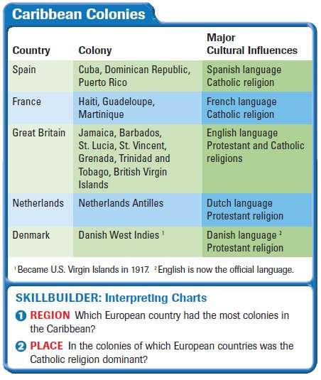
7 Island Groups of the Caribbean Greater Antilles large islands (Cuba, Jamaica, Hispaniola, & Puerto Rico) Lesser Antilles smaller islands southeast of Puerto Rico


8 Amazon River 2 nd longest river in the world 4,000 miles west to east Carries more water to the ocean than next 7 longest rivers combined!!
9


10 Travel Channel: Amazon Pink Dolphins of the Amazon Video!
11 Climate & Vegetation 1. Tropical wet: around equator, rainforest 2. Tropical wet & dry: South America savannas 3. Semi-arid: dry with some rain, grasslands 4. Desert: northern Mexico, Argentina, Peru 5. Humid sub-tropical: rainy winter, humid summers (like us!) 6. Mediterranean: hot summer, cool winter, Chile 7. Marine West Coast: rainy summer & winter Chile & Argentina 8. Highlands: in the mountains
12


13 Vegetation The natural vegetation of Latin America varies according to climate and ranges from lush tropical rainforest evergreens to desert cacti. canopy = the tops of tall trees that come together to form a dense covering.


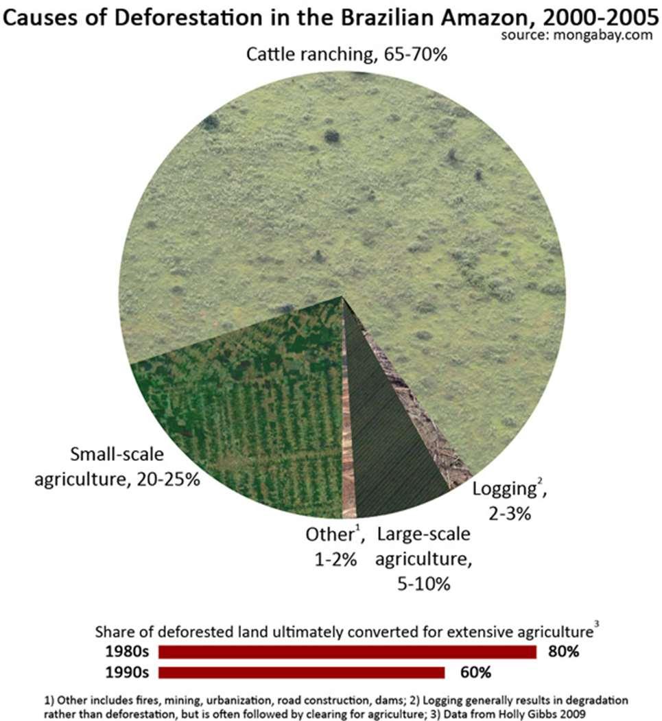
14 Tropical Climates Deforestation = the cutting down and clearing away of trees in the rain forest

15 Deforestation in Bolivia from 1975 to 2000
16
17

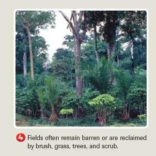
18 Slash & Burn Slash-and-burn farming = traditionally used by migrant farmers, they cut down all the plants and strip any trees of bark. After the plants and trees have dried out, they are set on fire, the ash helps the soil, but the soil is only good for 2-3 years, when this happens the farmer moves on and the process repeats itself.
19


20 Question??? Can you travel to the equator and go scuba diving in the morning and snowboarding in the afternoon? YES YOU CAN!!!!!!! Because of Vertical Climate Zones


21 Vertical Climate Zones Highland climates are commonly arranged vertically by altitude into 4 major zones Vertical climate refers to the pattern of weather in a region whose growth patterns are primarily affected by elevation. In vertical climate zones, the climate becomes colder as the elevation increases
22 Comparing Climate Regions Buenos Aires, Argentina 34*S/ 58*W 90 Dallas Texas 33*N/97*W J F M A M J J A S O N D J F M A M J J A S O N D What is the major difference you can see from the two climate charts? The two charts are opposite to each other This is because Dallas is in the Northern Hemisphere and Buenos Aires is in the Southern Hemisphere. Our winter is their summer, and our summer is their winter.


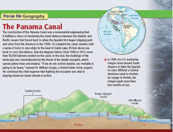
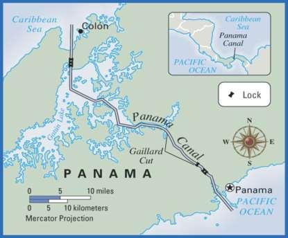
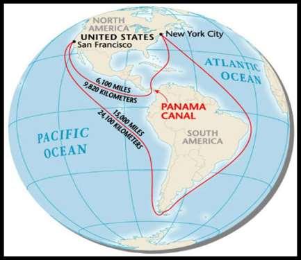
23 Canal system that splits the country of Panama in half, allowing boat traffic to pass through the isthmus of Panama and not have to go all the way around South America to have access between the Atlantic and Pacific oceans. Panama Canal
24

25 Trans-Andean Highway, Peru Connects Lima (capital of Peru) to Chile through the Andes Extremely curvy to compensate for the extreme uphill and downhill.
26
27 Did you finish your chart? If YES Go to tware.com/south_ameri ca_geography.htm Play the countries review games Record your scores on the back of your chart If NO Go back through the ppt and write down whatever is underlined. Then following the directions under If YES
28 Good morning!!!! Pick up the yellow chart from the front table Copy down the questions in the box. See if you can come up with the answers These are coming DIRECTLY from the FINAL EXAM!!!! Canada s longest river Rocky and flat area surrounding Hudson Bay Longest river in the US
29 Take out your physical geography chart from yesterday!!!!!
30 YOU HAVE A MAP QUIZ TODAY!!!! Study NOW!!!! You have a map that you filled out on Monday. If not, use p. A23 and A25 in textbook (Central America and South America)
31 TAKE OUT YOUR WARM UP AND HUMAN GEO NOTES FROM YESTERDAY Tectonic plates that spread apart and create volcanos Caused by drought and over-grazing; spread of desert into more fertile areas Separation of races in South Africa; ended with help from Nelson Mandela
32 You will have 20 minutes to finish your poster and argument! Argument needs to be at least 7 sentences It can be on the back of your poster Use white paper and markers for poster Poster needs to be neat and colored Turn in to me when finished


33 Human Geo of Latin America

34 Fill in the 8 Blanks Latin America is generally understood to consist of the entire continent of South America in addition to,, Mexico Central America and the islands of the Caribbean whose inhabitants speak a Romance language. The peoples of this large area shared the experience of conquest and colonization by the Spanish and Portuguese from the late 15th through the 18th century as well as movements of Independence in the early 19th century.

35 4 Sub regions of Latin America Mexico Central America & the Caribbean Islands Spanish-speaking South America Brazil

36 Mexico

37 Colonialism and Independence Was originally occupied by native people In 1519, Hernando Cortez (of Spain) landed on the coast and began the Spanish conquest of Mexico. By 1521, Cortez and his soldiers had conquered the native people of Mexico Mexico
 The Institutional Revolutionary Party in 1929 helped introduce democracy and brought political stability Redistributed land to")
38 Mexico Independence from Spain came in 1821 Land distribution was unfair (few rich landowners with poor peasants working on the haciendas (estates or ranches) The Institutional Revolutionary Party in 1929 helped introduce democracy and brought political stability Redistributed land to peasants


39 The Aztecs Mexico Arose in the Valley of Mexico Complex political system with an emperor Worshipped many gods & goddesses


40 Built Tenochtitlan Mexico Capital city of beautiful temples, palaces, gardens, and lakes Here they practiced human sacrifice in their temples Destroyed by Cortez Today is Mexico City, the country s capital


41 Mexico A Meeting of Cultures The Spanish brought Language and Catholic religion Mestizo People of mixed Spanish and Native American heritage


42 Diego Rivera ~ Used art to educate Mexico Created huge murals that combined modern forms with traditional designs to present the daily life and history of the country. Most famous mural is in Detroit, Michigan


43 Frida Kahlo ~ Mexican artist whose tormented paintings gave her great fame and changed the art world Featured on the cover of Vogue magazine 2002 movie staring Salma Hayek about her life. Mexico


44 Mexico Economics Problems Income gap: gap between rich and poor Need to develop a more industrial economy NAFTA North American Free Trade Agreement: cooperation on trade and economic issues among Mexico, U.S., and Canada
45


46 Central America & the Caribbean


47 Natives Central American & the Caribbean Cultural Hearth: Central America is a place from which ideas spread, and cross.
 Pyramid shaped temples")


48 The Maya Central America (Yucatan Peninsula) Pyramid shaped temples noted for the only known fullydeveloped written language of the pre- Columbian Americas Pyramid at Tikal, one of the Mayan civilization's most spectacular cities


49 The Maya continued Pictures of Ballcourts Skilled in mathematics Developed concept of zero Calendar based on orbit of the earth & sun (365 ¼ day calendar) Invented Game that is a cross between basketball & soccer

50 Central American & the Caribbean Colonizers Spanish in Central America Spain controlled Central America until the 19 th century United Provinces of Central America: name taken up by region after independence in 1823 By late 1830 s, region had broken up into separate nations Spanish in Caribbean Established sugar plantations and forced natives to work them until the arrival of African slaves
51

52 Economy Central American & the Caribbean In general, most people in the countries of this region are poor. This is a legacy of colonialism Informal Economy Jobs that take place outside official channels. Examples: street vendors, shoe shiners, etc.

53 Central American & the Caribbean Music of the Caribbean Calypso: combines musical elements of Africa, Spain and the Caribbean. Songs are accompanied by steel drums, guitars, and improvised lyrics Reggae: developed in Jamaica in 1960 s, deal with social problems and religion Bob Marley: pioneer of reggae
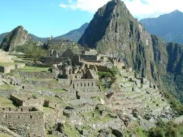
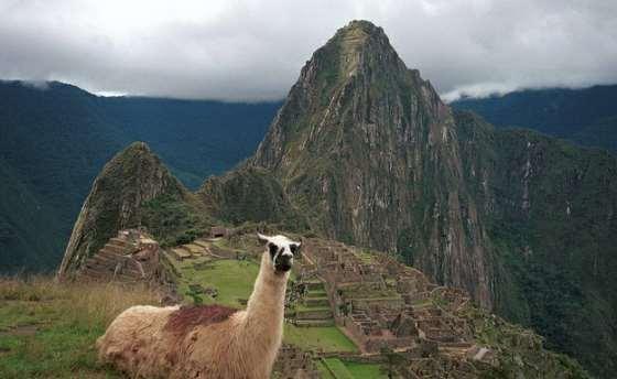
54 Take out your Human Geography of Latin America notes from Friday!!!! Good afternoon! Sit down be quiet!


55 South America


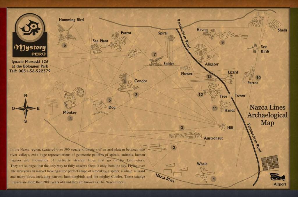
56 The Nazca Period: Nazca Lines What the heck?! They were first discovered by the Peruvian archaeologist Toribio Mejia Xesspe, who spotted them when hiking through the foothills in 1927


57 The Nazca Period: Nazca Lines **NAT GEO!** asca-lines-decoded VIEW MORE! du.tw/2010/12/15/thistime-not-for-africa-nazcalines/
58


59 Alien Theory: Swiss writer Erich Von Daniken claimed in the 1960s that advanced beings from outer space traveled to Earth in spaceships thousands of years ago. They reproduced with the ape-like ancestors of humans, thus creating human beings. These aliens built many monuments, such as Stonehenge, the pyramids in Egypt, and the Mayan temples in Mesoamerica. The Nazca lines were runways for the space gods as they arrived and departed. modern Reasoning the lines are too straight to not do from the air.


60 The Inca Ancient civilization located in the Andes Mountains in South America Empire extended 2,500 miles, from the capital of Cuzco Invaded and conquered by Francisco Pizarro and the Spanish Spanish-speaking South America


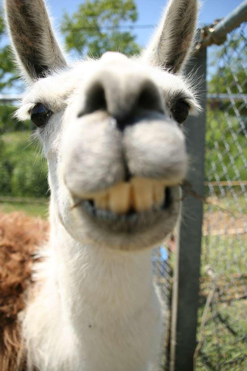
61 Quechua: Incan language replaced by Spanish Llama Legends: The Incas had no wheeled vehicles. They did not have horses or cows. High in the Andes, the llama was the most important animal. The llama was used for transportation. It provided the Incas with wool and food.
62

63 Machu Picchu Lost city of the Inca Machu Picchu Incan city in the Andes mountains - discovered in 1911 untouched!!
64
65 Spanish-speaking South America Independence and After Inspired by the American Revolution, South America countries sought their independence from Spain in the mid 1800 s Afterwards, governments were oligarchies (gov t by the few) and military rule This authoritarian rule delayed the development of democracy, which is still having effects on the region today.
66 Spanish-speaking South America
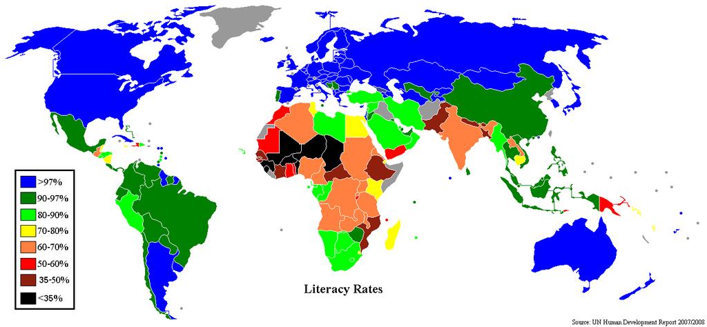
67 Economy Spanish-speaking South America Wide variety of products: crops, fishing industry, minerals (mining in the Andes) Advantages include: climate, vegetation, resources, and landforms Literacy Higher literacy rates than any other Latin American region Education extremely important
68


69 A Divided Continent Brazil Treaty of Tordesillas: 1494 this gave part of Brazil to Portugal The colonizers were looking for gold and silver but found none. Instead, they cleared out huge areas of forest where they created sugar plantations

70 The Portuguese empire ruled out of Brazil from 1807 to 1821 after Napoleon invaded Portugal! Brazil

71 Economy Brazil Brazil is a growing economic power. Much of this power is based on its vast area, its abundance of natural resources, and its people. Its economy is the tenth largest in the world. Its diverse population of about 170 million people contributes to its economic strength.


72 Culture Brazil Mixture of native, Portuguese, and African influences. Speak Portuguese and have the largest Catholic population in the world!


73 Carnival festival celebrated just before the beginning of Lent, the Christian holy season that comes before Easter the biggest Carnival is held each year in Rio de Janeiro, Brazil


74 m/watch?v=ktc3pv7d5vy


75 Samba: A Brazilian dance with African influences Capoeira: a martial arts and dance that developed in Brazil by African slaves who were hiding their fight training. Soccer is a huge part of Brazil as well. They will host the 2014 World Cup Brazil is the most successful national football team in the history of the FIFA World Cup, with five championships, followed by Italy. They are also the most successful team in the FIFA Confederations Cup with three titles.
Human Geo of Latin America
 Human Geo of Latin America Fill in the 8 Blanks Latin America is generally understood to consist of the entire continent of South America in addition to,, Mexico Central America and the islands of the
UNIT 3 Extra Review for Chapters 9-11
 UNIT 3 Extra Review for Chapters 9-11 Mexico Central America Caribbean Islands Middle America is Central America, Mexico, and the Islands of the Caribbean Central America is a region within Middle America.
Mrs. Reifsnyder World Geography. Unit 8: Latin America Study Guide SOLs Addressed: WG. 1c, 2b, 3c, 4, 10b/c
 Mrs. Reifsnyder World Geography Unit 8: Latin America Study Guide SOLs Addressed: WG. 1c, 2b, 3c, 4, 10b/c Essential Questions: - In what ways do physical, economic, and cultural characteristics influence
Chapter 10 Section 1. Mexico
 Chapter 10 Section 1 Mexico Spanish Conquest 1519 Hernando Cortés arrives; marched to the Aztec city, Tenochtitlan Mexico City Native way of life destroyed; 1521 the Aztecs are conquered Mexico becomes
Latin America 11/4/2013. Latin America Today. 580 million people 9% of the world s population Diverse backgrounds:
 Latin America Chapter 10 Human Geography Latin America Today 580 million people 9% of the world s population Diverse backgrounds: Native Americans Europeans Africans Asians 1 Population 393 million live
LATIN AMERICA. Mexico Central America Caribbean Islands South America
 LATIN AMERICA Mexico Central America Caribbean Islands South America HISTORY First Settlers Hunters/gatherers from Asia crossed land bridge connecting Asia and Alaska Learned to farm over time Maize (corn)
WORLD GEOGRAPHY. Hector Rodriguez
 Mr. Chavira 9th Period WORLD GEOGRAPHY Hector Rodriguez P a g e 1 Table of Contents Latin America Page 2 o Maps Economic Map Page 3 Political Map Page 4 Population Map Page 5 Physical Page 6 o Notes Physical
Latin America. Physical Geography
 Latin America Physical Geography Regions Latin America can be divided into separate regions based on physical geography or cultural geography. Regions If we look at physical geography Latin America has
CHAPTER 12. South America. Section 1: Natural Environments Section 2: History and Culture Section 3: South America Today. HOLT World Geography
 CHAPTER 12 South America Section 1: Natural Environments Section 2: History and Culture Section 3: South America 1 Section 1 Natural Environments Objectives: What are the major landforms and rivers of
1st Period Mr. Chavira WORLD GEOGRAPHY. Hector Rodriguez
 1st Period Mr. Chavira WORLD GEOGRAPHY Hector Rodriguez P a g e 1 Table of Contents Latin America Page 2 o Maps Economic Map Page 3 Political Map Page 4 Population Map Page 5 Physical Page 6 o Notes Physical
Latin America. Chapter 9 Physical Geography
 Latin America Chapter 9 Physical Geography Latin American Regions Middle America includes Mexico and the Central American countries The Caribbean Islands South America Mexico Landforms Sierra Madre Oriental
Latin America. Introduction
 Latin America Introduction What are the 5 Themes of Geography? Draw lines to connect the theme to the definition: Location How humans and the environment impact each other Physical and human characteristics
Mexico. Chapter 10. Chapter 10, Section
 Chapter 10, Section World Geography Chapter 10 Mexico Copyright 2003 by Pearson Education, Inc., publishing as Prentice Hall, Upper Saddle River, NJ. All rights reserved. Chapter 10, Section World Geography
Latin America s Physical Geography. EQ: What are characteristics of Latin America s physical features?
 Latin America s Physical Geography EQ: What are characteristics of Latin America s physical features? Your Task: We are going to participate in a Museum Walk! You will travel around the room with a partner
Objective. Students will familiarize themselves with the physical features and climates of Latin America.
 Journal Write KWL What do you KNOW about Latin America? What do you WANT TO KNOW about Latin America? What did you LEARN today that you didn t know before? Latin America Objective Students will familiarize
Warm-up. A. Exports only manufactured goods B. Should import fewer products C. Needs to import more products D. Does not import or export
 Warm-up As with any small country, Cuba has fewer natural resources than countries such as Brazil. This affects their trade in that Cuba A. Exports only manufactured goods B. Should import fewer products
Essential Questions. 1. How have historical figures and events affected South America today?
 South America Essential Questions 1. How have historical figures and events affected South America today? 2. How has location affected the development of countries in South America? 3. How has the role
Geographic Qualities of South America
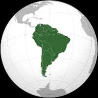
 Geographic Qualities of South America 1. South America is the fourth largest continent in area. It is located in the Western Hemisphere, lying southwest of North America. Most of South America lies in
6th Grade Third Nine Weeks Benchmark Assessment
 6th Grade Third Nine Weeks Benchmark Assessment Multiple Choice Identify the choice that best completes the statement or answers the question. Key Concepts 1 Latin America is located in the A Northern
2018 Spring Semester Final : STUDY GUIDE
 Name: Hr: 2018 Spring Semester Final : STUDY GUIDE My final is on:, May My final will have questions and will be COLONIZATION OF NORTH & SOUTH AMERICA - Match the regions with the European countries that
Regional Atlas: Introduction to Latin America
 Chapter 9, Section World Geography Chapter 9 Regional Atlas: Introduction to Latin America Copyright 2003 by Pearson Education, Inc., publishing as Prentice Hall, Upper Saddle River, NJ. All rights reserved.
STUDY GUIDE. The Land. Physical Features of Latin America. Chapter 8, Section 1. Terms to Know DRAWING FROM EXPERIENCE ORGANIZING YOUR THOUGHTS
 For use with textbook pages 193 198. The Land Terms to Know cordillera A mountain range that runs parallel to another mountain range (page 194) altiplano A high plain (page 194) escarpment A steep cliff
6th Grade Western Hemisphere Geography
 6th Grade Western Hemisphere Geography Multiple Choice Identify the choice that best completes the statement or answers the question. 1 Latin America is located in the A Northern Hemisphere. C Western
The Lesser Antilles. Dominican Republic), and Puerto Rico
, and Puerto Rico") The Caribbean Islands are archipelagoes or groups of islands. The major archipelagoes are: The Greater Antilles - Cuba, Jamaica, Hispaniola (Composed of Haiti and the Dominican Republic), and Puerto Rico
The Caribbean Islands are archipelagoes or groups of islands. The major archipelagoes are: The Greater Antilles - Cuba, Jamaica, Hispaniola (Composed of Haiti and the Dominican Republic), and Puerto Rico
Comprehension Questions:
 Unit 3: Central & South america Comprehension Questions: 1. What is the driest desert on earth? Atacama Desert 2. What two water routes were discovered in the 1500s to get around the tip of South America?
Latin America. Physical Geography
 + Latin America Physical Geography + I. Landforms A. Caribbean & Central America 1. Mexico is dominated by two mountain chains, collectively called the Sierra Madre. A high plateau is situated in between.
Many ecotourists visit the various natural habitats in Central America. Why do you think ecotourism has become so popular?
 Chapter 9 Middle America and Spanish Speaking South America pg. 252 287 9 1 Central America pg. 255 259 Connecting to Your World What is one country in Central America that promotes ecotourism? Many ecotourists
Exploring Mexico. Directions: Complete the paragraphs below. Write the correct word from the Word Bank to complete each sentence.
 Exploring Mexico Section 1 10 Directions: Complete the paragraphs below. Write the correct word from the Word Bank to complete each sentence. Word Bank United States Central Plateau irrigation isthmus
Ancient Civilizations of the Western Hemisphere. Maya, Aztec, & Inca
 Ancient Civilizations of the Western Hemisphere Maya, Aztec, & Inca THE MAYA The maximum extent of the Maya Maya - Location southern Mexico into northern Central America called the Yucatan Peninsula Maya
Mrs. Davis s Adventures
 Mrs. Davis s Adventures Latin America Countries & Political Map NAME: DATE: PERIOD: DIRECTIONS: Use your mapping skills and textbook pages: 127, 97, and 3 to complete Mrs. Davis s Story. Transfer the countries
Friday, November 10, 2017
 Friday, November 10, 2017 Andes and Midlatitude Countries Objective: Summarize the main physical features and regions of the Southern Cone. Identify and locate the urban centers and understand the pattern
A funny sounding lake. South American Landforms, Climate, and Vegetation
 A funny sounding lake South American Landforms, Climate, and Vegetation 3 4 Essential Question: How have physical features and climate affected the population distribution of Latin America? 5 I. Landforms
CHAPTER Latin America. Regional Atlas Study Guide. 2 Chapter A. As You Read. B. Reviewing Vocabulary
 CHAPTER 28 9 Many Th ew inventions new Regional Atlas Study Guide Latin America Directions: As you work through the Regional Atlas, complete the chart below by writing two details about each Latin American
South America. Land of Color and Contrast
 South America Land of Color and Contrast Home to: *The world s largest river system *The longest mountain chain, and second tallest mountains *Earth s driest desert *One of the world s great grassland
Brazil. Population & Culture
 Brazil Population & Culture Population of Brazil Largest country in South America 200 million people (2012 est) Growing population - approximately 1% per year Life expectancy - approx 72 years Population
South America. pg. 520 (5 th) pg. 523 (6 th )
 pg. 523 (6 th )") South America pg. 520 (5 th) pg. 523 (6 th ) Venezuela Rich in Oil Lake Maracaibo Called Little Venice pg. 572 (5 th) pg. 574 (6 th ) Caracas 8 miles Inland 3000 pg. 572 (5 th) pg. 574 (6 th ) Caracas
South America pg. 520 (5 th) pg. 523 (6 th ) Venezuela Rich in Oil Lake Maracaibo Called Little Venice pg. 572 (5 th) pg. 574 (6 th ) Caracas 8 miles Inland 3000 pg. 572 (5 th) pg. 574 (6 th ) Caracas
Introduction to Africa
 Introduction to Africa Did you know? Africa has more countries than any other continent. The Sahara is a desert that is the size of the U.S. It s the world's largest desert. Most of the world s gold and
Exploring South America Learning Lapbook with Study Guide
 A J T L Grades 1-4 Exploring South America Learning Lapbook with Study Guide A Journey Through Learning www.ajourneythroughlearning.com Copyright 2013 A Journey Through Learning 1 Authors-Paula Winget
6th Grade Western Hemisphere Geography
 6th Grade Western Hemisphere Geography Multiple Choice Identify the choice that best completes the statement or answers the question. 1 Latin America is located in the A Northern Hemisphere. C Western
Latin America and The Caribbean. A Closer Look.
 Latin America and The Caribbean A Closer Look. Mexico Capital: Mexico City The Location of Mexico Mexico is the second-largest country by size and population in Latin America.but the Largest Spanish -
THE PRE-COLUMBIAN CIVILIZATIONS MAYA AZTEC INCA
 THE PRE-COLUMBIAN CIVILIZATIONS MAYA AZTEC INCA THE MAYAN CIVILIZATION Where were the Maya located? The Maya were located mainly in the Yucatan Peninsula, and stretched to Belize & Guatemala The civilization
LATIN AMERICAN INDEPENDENCE MOVEMENTS : An Age of Revolutions
 LATIN AMERICAN INDEPENDENCE MOVEMENTS 1750-1914: An Age of Revolutions BACKGROUND Indigenous peoples and civilizations Maya, Aztec, Inca European Colonization, 1500s Spain, Portugal, France American Revolution,
Central America and the Caribbean. The Link Between North and South America
 Central America and the Caribbean The Link Between North and South America Today, the combined population of Central American countries is over 40 million larger than all of Canada. Combined, the 7 nations
Mesoamerican Civilizations
 Mesoamerican Civilizations Human Migration Turn to page 237 and answer the two geography skillbuilder questions: What two continents does the Beringia land bridge connect? From where do scholars believe
GEOGRAPHY. Peru holds all of these natural wonders!
 GEOGRAPHY Have you ever heard of the Andes Mountains? The Amazon River and Rainforest? How about the Pacific Ocean? Peru holds all of these natural wonders! It s landscape is filled with MANY diverse land
Central America and the Caribbean. The Link Between North and South America
 Central America and the Caribbean The Link Between North and South America Today, the combined population of Central American countries is over 40 million larger than all of Canada. Combined, the 7 nations
Unit 5/Chapter 8 ticket Central America and the Caribbean
 Unit 5/Chapter 8 ticket Central America and the Caribbean Important Vocabulary Latifundia inifundia ISTHMUS : a strip of land two large strips of land ARCHIPELAGO : a or of islands BIODIVERSITY : an as
LATIN AMERICA. Mexico, Central America and South America
 LATIN AMERICA Mexico, Central America and South America Physical Geography: Plate tectonics pushing together formed what major mountain range?? Andes Mountains Natural disasters the area is prone to:
Maya, Aztec, and Inca Civilizations
 Maya, Aztec, and Inca Civilizations Mesoamerica Mesoamerica = Mexico & Central America Mesoamerica Some of the greatest civilizations in the Americas developed in Mesoamerica The Maya and Aztec lived in
STANDARDS: Brain Wrinkles
 STANDARDS: SS6G3 The student will explain the impact of location, climate, distribution of natural resources, and population distribution on Latin America and the Caribbean. a. Compare how the location,
2. The most important crop in Mexico. 3. The Priest who spoke against Spain. 5. Ancient Aztec city, now Mexico City
 Name: Date: Did you hear about what happened at the laundromat last night? Three clothespins held up two shirts! Clues are listed below. Print the word that matches the clue on the blank line by the clue.
LOCATION, CLIMATE, AND NATURAL RESOURCES OF MEXICO
 SS6G3 The student will explain the impact of location, climate, distribution of natural resources, and population distribution on Latin America and the Caribbean. a. Compare how the location, climate,
Chapter 19 Test on South America
 Name Part 1 - Labeling (27 pts.) Chapter 19 Test on South America Score A. Locate the countries and territory contained in the word box below on the map of South America on the next page. Write the name
Part 1: Physical Geography
 Part 1: Physical Geography Highlands Lowlands Wide range in elevation creates diverse climate zones in the region A mountain chain stretches along the western edge of the American continents for more
World of the Incas and the North American Indians. Willow LeTard and Kevin Nguyen
 World of the Incas and the North American Indians Willow LeTard and Kevin Nguyen World of the Twantinsuyu 1300 c.e. in the Andean highlands Notable advances in metallurgy and architecture The Incas had
Brain Wrinkles. Location, Climate, & Natural Resources of. Where People Live & How They Trade
 Location, Climate, & Natural Resources of Where People Live & How They Trade It s south of the US, east of the Pacific Ocean, and west of the Gulf of Mexico & Caribbean Sea. It s great that it s located
Why is the US industry and agriculture prosperous? The US industry and agriculture is so prosperous because it has many different natural resources.
 Ch. 1-7 Study Guide Why is the US industry and agriculture prosperous? The US industry and agriculture is so prosperous because it has many different natural resources. What likely drew immigrants to the
Chapter 7 Mexico, Central America, & the Caribbean
 Chapter 7 Mexico, Central America, & the Caribbean Chapter 7, Lesson 1 Physical Geography of Mexico, Central America, & the Caribbean Physical Characteristics of Mexico and Central America An isthmus narrow
There are two countries in the Iberian Peninsula: Spain and Portugal. The name of the peninsula comes from the first inhabitants, the Iberians.
 Spain There are two countries in the Iberian Peninsula: Spain and Portugal. The name of the peninsula comes from the first inhabitants, the Iberians. After them, the peninsula was invaded by the Celts,
Geography of CA and CI
 Geography of CA and CI Caribbean Islands Central America -Central America (CA) is an isthmus connecting North America to South America. It consists of 7 countries. -The Pacific side of CA is covered by
Latin American Revolutions of the early 1800s
 Latin American Revolutions of the early 1800s I. Background The Spanish/Portuguese Colonial System A. The Roles of Colonies fulfillment of mercantilism for Spain and Portugal 1. Plantation Agriculture
Oceania. Australia, New Zealand, and the Pacific Islands. Physical Geography. Where is Australia located?
 Oceania Australia, New Zealand, and the Pacific Islands Physical Geography Australia New Zealand Oceania Where is Australia located? Australia & Oceania are a group of islands located between Asia, Antarctica,
April 02, Inca. The Inca controlled a vast empire covering parts of modern day Peru, Ecudor, Bolivia, Chile, and Argentina.
 Inca The Inca controlled a vast empire covering parts of modern day Peru, Ecudor, Bolivia, Chile, and Argentina. Find the Incan Empire on your map and color it in. April 02, 2014 Cuzco was the capital
South American Countries. Capital Location Population Terrain Climate
 South American Countries Capital Location Population Terrain Climate Andes Mountains Four large areas that make up the Central Plains: Llanos, the Selva, the Gran Chaco, and the Pampas Brazilian Highlands
LOCATION, LOCATION, LOCATION! Mexico, Venezuela, Cuba, and Brazil
 LOCATION, LOCATION, LOCATION! Mexico, Venezuela, Cuba, and Brazil GPS and E.Q. GPS: SS6G3 The student will explain the impact of location, climate, distribution of natural resources, and population distribution
DATE: A Short Introduction
 Question: What do you already know about Brazil? Read the article below and then answer the questions. A Short Introduction Brazil is big. It is the largest country in South America, and the fifth largest
Chapter 20. The Physical Geography of Africa South of the Sahara
 Chapter 20 The Physical Geography of Africa South of the Sahara Chapter Objectives Identify the major landforms, water systems, and natural resources of Africa south of the Sahara. Describe the relationship
Chapter 10 Study Guide SOUTH AMERICA
 Chapter 10 Study Guide SOUTH AMERICA When Spain and Portugal competed for trading lands in the New World, who came up with the line of demarcation to settle the dispute? The Caribbean Countries: Who was
Geography: Latin America (ch. 8, 9 and 10) page 1. p. 178: What areas make up Latin America? Mexico, Central Amer., Caribbean Islands, South America
 page 1. p. 178: What areas make up Latin America? Mexico, Central Amer., Caribbean Islands, South America") Geography: Latin America (ch. 8, 9 and 10) page 1 p. 178: What areas make up Latin America? Mexico, Central Amer., Caribbean Islands, South America Chapter 8: Physical Geography of Latin America I. The
Geography: Latin America (ch. 8, 9 and 10) page 1 p. 178: What areas make up Latin America? Mexico, Central Amer., Caribbean Islands, South America Chapter 8: Physical Geography of Latin America I. The
Unit 5: Latin America Today
 Unit 5: Latin America Today In this unit, you will turn your attention to Latin America. You will study the geography of some Latin American countries. You will learn about their history, politics, revolutions,
The Northern Tropics
 The Northern Tropics The Guianas Countries Guyana, Suriname, French Guyana Culture reflects colonial history Official Languages Guyana English Suriname Dutch French Guyana - French Religions Suriname and
The Inca Civilization. Ashley Feltz, Ashley Hamilton, Ashley Giles, James Porter and Chris Bernard
 The Inca Civilization Ashley Feltz, Ashley Hamilton, Ashley Giles, James Porter and Chris Bernard History of the Inca Existed for 300 years, ruled all of South America for a hundred years.the sun was one
THE PRE-COLUMBIAN CIVILIZATIONS MAYA AZTEC INCA
 THE PRE-COLUMBIAN CIVILIZATIONS MAYA AZTEC INCA THE MAYAN CIVILIZATION Where were the Maya located? The Maya were located mainly in the Yucatan Peninsula, and stretched to Belize & Guatemala The civilization
Land and People of Peru and Ecuador
 Guide to Reading Main Idea Peru and Ecuador share similar landscapes, climates, and history. Terms to Know navigable foothills empire Reading Strategy Create two ovals like these. Under each heading, list
Review Game. Latin America History. Inca and Aztec*Columbian Exchange*Atlantic Slave Trade*Triangular Trade Cuban Revolution*Zapatistas
 Inca and Aztec*Columbian Exchange*Atlantic Slave Trade*Triangular Trade Cuban Revolution*Zapatistas Latin America History Review Game Grade 6 Social Studies Department East Cobb Middle School 2016 Which
*Latin America spans 7,000 miles, from Mexico to Tierra Del Fuego. *3 Regions: Central America, South America, and the Caribbean.
 Physical Geography Latin America spans 7,000 miles, from Mexico to Tierra Del Fuego *3 Regions: Central America, South America, and the Caribbean. *Intro clip: http://www.youtube.com/watch?v=cffp6rza3
Indigenous People and Community Culture Unit
 Indigenous People and Community Culture Unit Big Idea: Culture, Culture, everywhere from me to you, from here to there, from past to present, Culture, Culture, Culture! 1 Vocabulary - Culture: The characteristics,
Portuguese Language - Fostering National Unity
 Geography Brazil Brazil Portuguese Language - Fostering National Unity 11 dialects of Portuguese Influenced by Amerindian and African languages, creating differences between Portuguese spoken in Brazil
11/16/15. Today s! Topic: " Latin America Independence Movement
 Classes begin at: 1st Block 8:35am 2 nd Block 10:05am Georgia Cyber Academy s mission is to provide an exemplary individualized and engaging educational experience for all students. Learning Target: I
Content Statement: Explain how Enlightenment ideals influenced the French Revolution and Latin American wars for independence.
 Reforms, Revolutions, and Chapter War 9.3 Section 3 Independence in Latin America Content Statement: Explain how Enlightenment ideals influenced the French Revolution and Latin American wars for independence.
Chapter 5 Middle America
 Chapter 5 Middle America Identifying the Boundaries Middle America, the geographic realm between the United States and the continent of South America, consists of three main regions: the Caribbean, Mexico,
How to play. The center aisle divides our class into 2 teams. Team members are NOT allowed to help their teammate when they are asked a question.
 Floaters & Sinkers How to play The center aisle divides our class into 2 teams. Each person will be responsible for answering a question for every round played. Team members are NOT allowed to help their
Summary Article: Mexico from Philip's Encyclopedia
 Topic Page: Mexico Summary Article: Mexico from Philip's Encyclopedia The United Mexican States is the world's largest Spanish-speaking country. It is largely mountainous. The Sierra Madre Occidental begins
Countries Of The World: Mexico
 Countries Of The World: Mexico By National Geographic Kids, adapted by Newsela staff on 06.07.18 Word Count 638 Level 800L Image 1: The pyramids of Guachimontones in Jalisco, Mexico. Mexico is a country
3. Which word is a synonym
 Name: Date: WEEK 33 1 Read the text and then answer the questions. You know where North America is, and you might also know where South America is. But there is an important place between them that you
The Mesoamerican cultures (1200BC- AD 1519)
") The Mesoamerican cultures (1200BC- AD 1519) Central America before the arrival of Europeans Click for Video There were many different cultures between 1200BC and AD 1519, but they share some important
The Mesoamerican cultures (1200BC- AD 1519) Central America before the arrival of Europeans Click for Video There were many different cultures between 1200BC and AD 1519, but they share some important
Travel agency new york south america peru
 Travel agency new york south america peru Personalize your trip of a lifetime with a fully customizable tour package. The local experts at Peru For Less offer the best travel service. News About the US
World Geography Ch. 7.2 Climate Regions of Latin America
 World Geography Ch. 7.2 Climate Regions of Latin America BR: D10 When you think of Latin America, what types of climates do you think are down there? Write down which of the following you believe are there:
SS7G1 The student will locate selected features of Africa.
 Standards SS7G1 The student will locate selected features of Africa. a. Locate on a world and regional political-physical map: the Sahara, Sahel, savanna, tropical rain forest, Congo River, Niger River,
Sub - Saharan Africa
 Sub - Saharan Africa 4/14/2015 Countries with Relative Importance GDP South Africa Gabon Botswana Land Size Sudan Chad Mozambique Madagascar Democratic Republic of the Congo (formerly Zaire) Population
Friday, November 10, 2017
 Friday, November 10, 2017 Human Geography of the Andes and Midlatitude Countries Language Objective: Analyze the demographic information from the Andean region of South America. Finish Geography Now activity
Central American Societies
 Central American Societies EARLY MESOAMERICANS Area of central Mexico, Yucatan Peninsula, and northern Honduras Mesoamerica The Olmec First known civilization in Mesoamerica Emerge 1200 BCE Collapse in
Fall of the Aztec & Incan Empires. Unit Seven Notes
 Fall of the Aztec & Incan Empires Unit Seven Notes FYI Did Ya Know According to Inca legends, the sun god Inti sent his son Manco Capac and his daughter Mama Ocllo to Earth. Before they took off, he
NEW SPAIN - MEXICO ( )
") NEW SPAIN - MEXICO (1521-1848) The Other Conquest In 1521, the Aztec civilization is conquered by the Spanish and over 75,000 allies. The Spanish call the new land, NUEVA ESPANA The Conquest is devastating:
NEW SPAIN - MEXICO (1521-1848) The Other Conquest In 1521, the Aztec civilization is conquered by the Spanish and over 75,000 allies. The Spanish call the new land, NUEVA ESPANA The Conquest is devastating:
Social Studies: The World
 Social Studies: The World What is the name of the continent that is labeled #1 on the map? North America What is the name of the continent that is labeled #2 on the map? South America What is the name
Chapter Objectives. Describe the dominant landforms and natural resources of Southeast Asia. Discuss Southeast Asia s climate and vegetation.
 Chapter Objectives Describe the dominant landforms and natural resources of Southeast Asia. Discuss Southeast Asia s climate and vegetation. The Land Section 1 Objectives Describe how tectonic plates and
Chile. World Geography South America
 Chile World Geography South America Chile Location Continent: South America Borders the Pacific Ocean Chile Overview Population: 17,789,267 (July 2017 est.) World Rank: 65 th Chile Overview Capital and
Unit 4: The Americas
 Unit 4: The Americas South America Main Idea Several early cultures in South America adapted to extreme environmental condi:ons. One of them, the Inca, built one of the biggest and most powerful empires
Physical characteristics and biomes:
 Physical characteristics and biomes: Sahel region, bordering Sahara Characteristics Area suffers from lack of rainfall, over grazing, which causes loss of vegetation and loss of inhabitable areas causing
Introduction. We hope you find these materials useful and would welcome any feedback.
 Introduction This planning pack was produced with teachers from County Durham following a visit to São Paulo. The materials support the teaching of geography at key stage one and two within the context