In-field and Remote Sensing for Precision Agriculture. John Nowatzki Extension Ag Machine Systems Specialist North Dakota State University
|
|
|
- Nora Goodman
- 6 years ago
- Views:
Transcription


1 In-field and Remote Sensing for Precision Agriculture John Nowatzki Extension Ag Machine Systems Specialist North Dakota State University
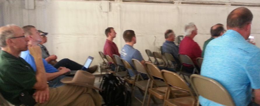
2 UAS in Precision Agriculture In-field Sensors Selecting UAS Equipment NDSU UAS Activities Current UAS Applications Future UAS Applications and Needs
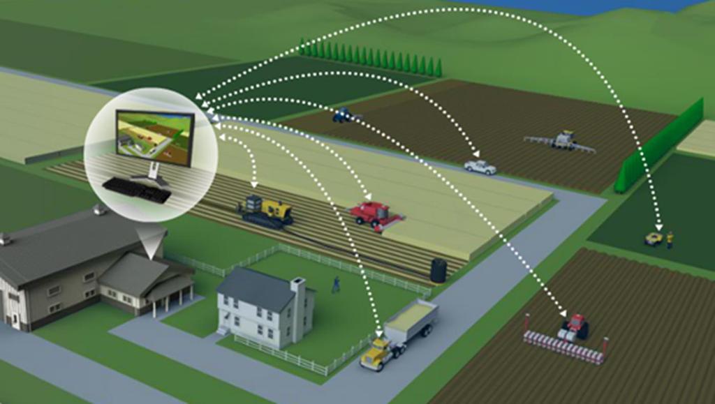


3 Precision Agriculture & Data Management Computer Software Commercial Services Big Data

4 Selecting suas Equipment for Agricultural Applications Multi-Rotor Fixed-wing Advantages Disadvantages Advantages Disadvantages Any Camera Short flight time Cover larger area Takeoff space Ease of use Small area Longer flight time Ability to hover Slower Speed Simpler structure More stable flight Vertical takeoff and landing Assistance for takeoff More complex Greater payload Larger in size Less expensive Smaller Payload Multiple sensors More expensive


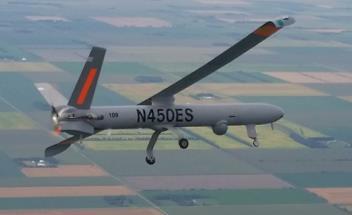
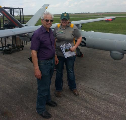
5 UAS Platforms Hermes 450 Small UAS Rules Phantom 3 3DR RTF X8 Altavian Trimble UX5 RF70 - Troybuilt
6 Small UAS Rules Less than 55 lbs. Remote Pilot Airman Certificate Line of Sight Daylight Hours 400 or Below


7 Remote Sensing for Agricultural Applications Color RGB Multi-spectral Hyper-spectral Vegetative Index NDVI


 Sentera")
 MicaSense")


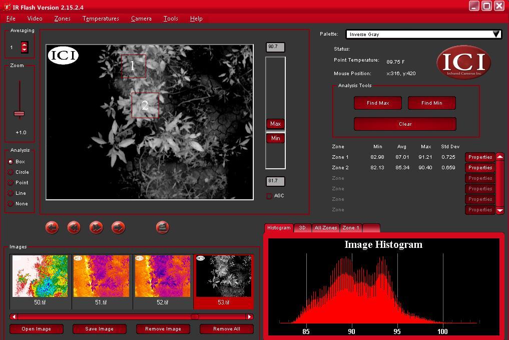
8 UAS Sensors Ximea Cameras GoPro Camer ICI 9640 S Thermal camera Hyperspectral Large area scanning EO/IR/NIR camera Sony NEX-5R camera with NIR Tetracam ADC Sentera dual sensor (4 band) Sentera Quad sensor (6 band) MicaSense Rededge Ximera Hyperspectral sensor Rikola Hyperspectral sensor Rikola Elbit EO/IR ICI 9640 Thermal Sentera Sony NEX-5R
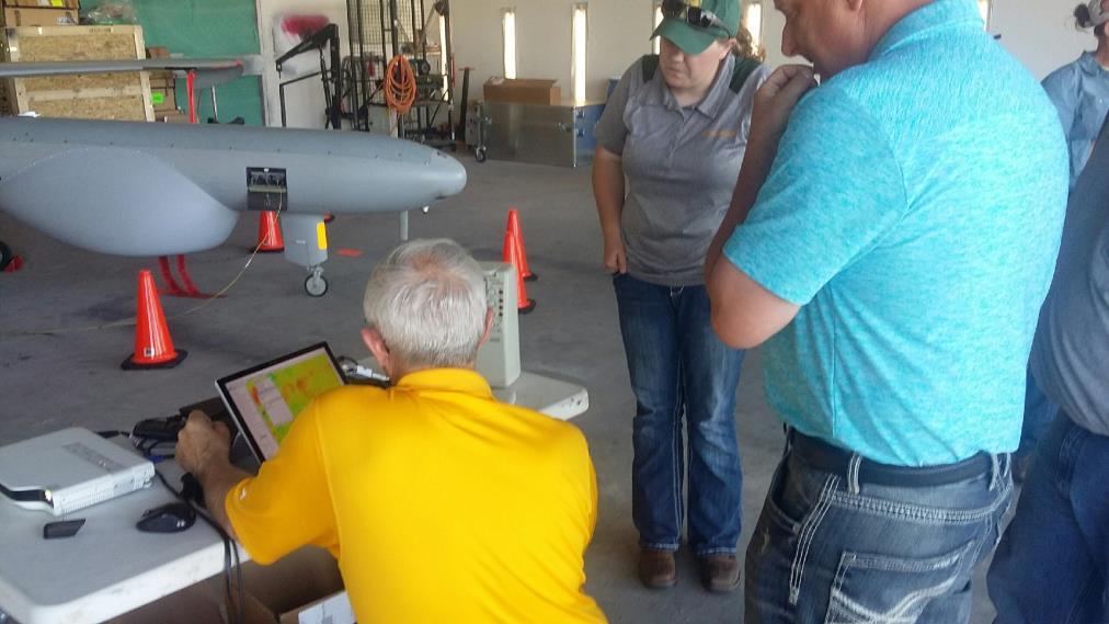
9 NDSU UAS Activities Small and Large UAV S Phantom 3 Trimble UX5


10 Large-scale UAS Project Imagery in May, June, July and August Color, Infrared Sensor 4,000, 6,000 and 8,000 ft Small UAS, Satellite, Ground and Yield Data All Imagery Securely Stored on NDSU Computers Objectives Uses for Crop Management Economic Value to Producers


11 Project Location Eastern ND
12 Hermes 450 UAS


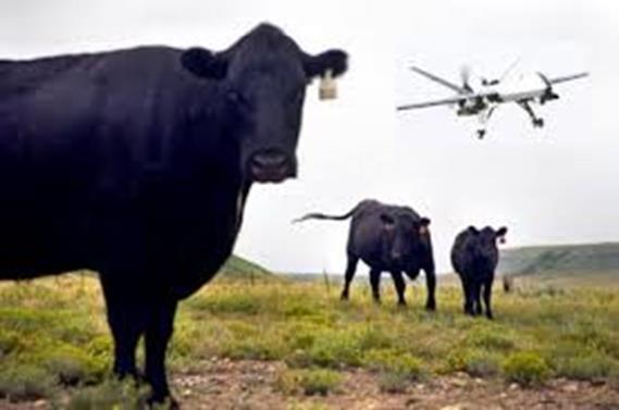
13 Hermes 450 UAS Control Center
14 Hermes 450 UAS Control Center
15

16 First Large UAS Civilian Flight in North Dakota

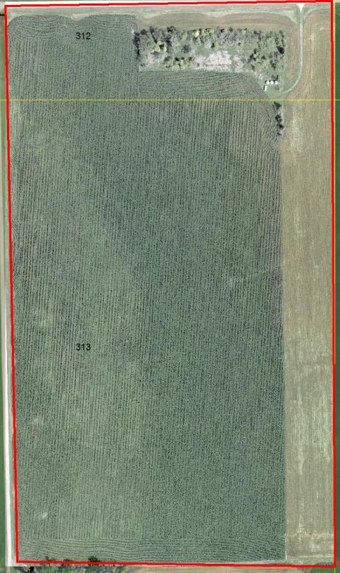
17 Landing the Hermes 450

18 View from CAP Chase Plane
19 Data Management Large UAS Entire Corridor Each Date Date May June July August Altitude 4,000 6,000 8,000 6,000 8,000 6,000 8,000 4,000 8,000 Image Quantity Total Size 2.0 TB 1.5 TB 0.5 TB 4.0 TB 1.5 TB 0.5 TB 2.0 TB 1.5 TB 0.5 TB 2.0 TB 2.0 TB 0.5 TB 2.5 TB Total Quantity of Imagery Collected during the Project: 10.5 TB Plus Small UAS Imagery Plus Image Analyses

20 NDSU Extension Role Facilitate Collaborate Educate


21 May Imagery: 4,000 6,000 8,000 4,000 8,000 6,000 Detailed Imagery - 50,000 Acres/Hour


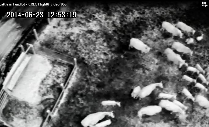
22 Analyses from Imagery: Cattle from 8,000


23 Cattle in May Imagery: 4,000


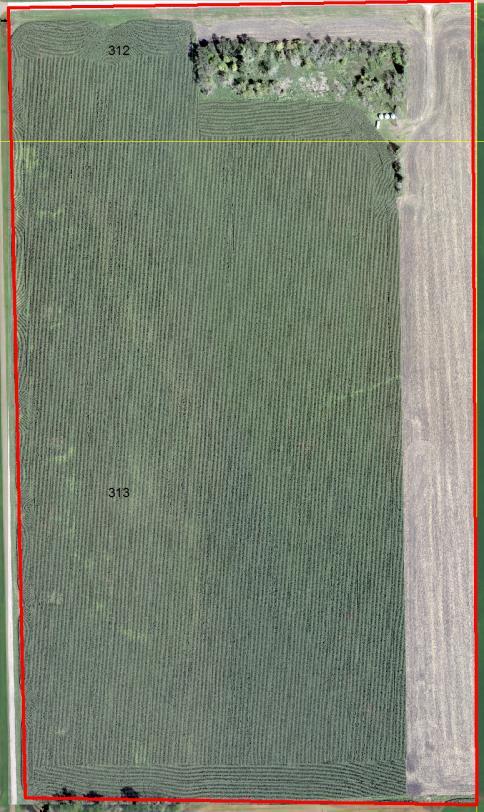

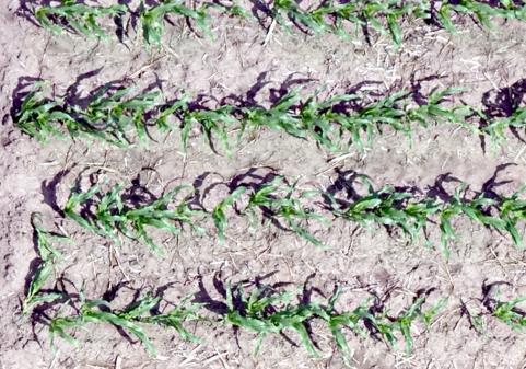
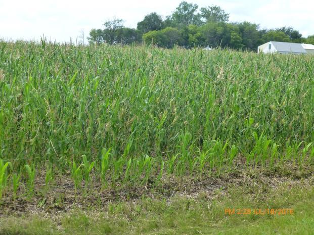
24 Corn Imagery: May June July - August

25 Analyses from Imagery: Zone Map

26 ~ 40 Acres Imagery 4,000 RGB Image 4 cm Pixel Size

27 ~ 200 x200 Imagery 4,000 RGB Image 4 cm Pixel Size

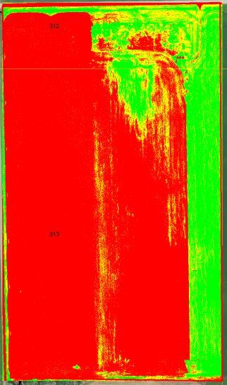
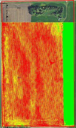
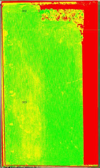
28 Imagery Issues: Time Between Images

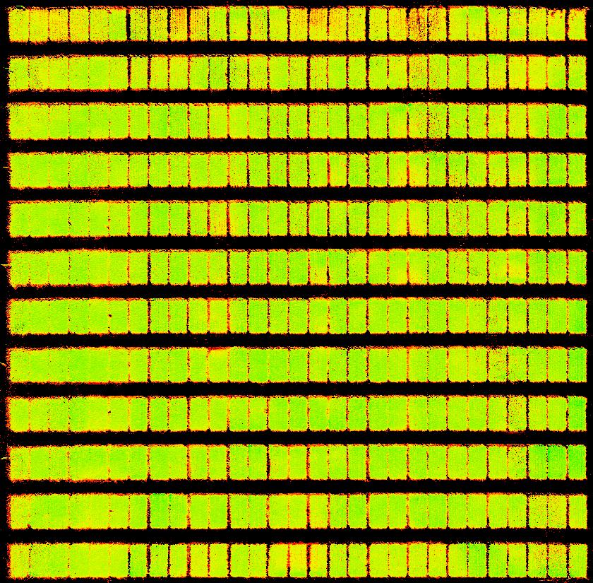
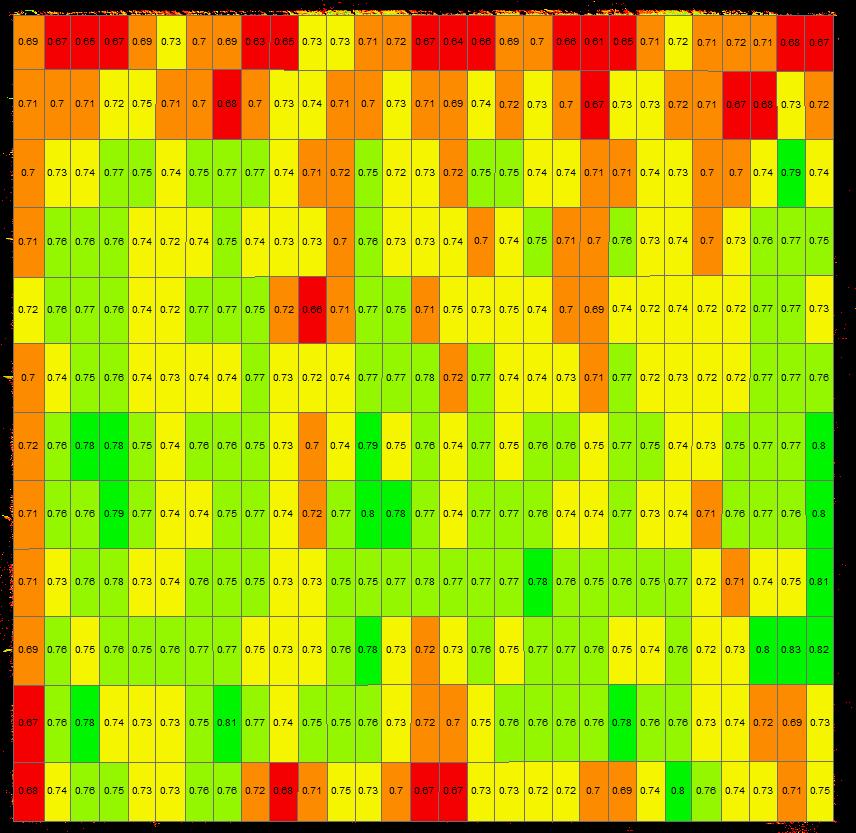
29 Imagery Issues: Time Between Images Color Image

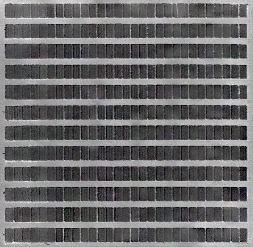
30 Imagery Issues: Time Between Images NDVI Image NDVI Mean= NDVI Mean=0.4975

31 Sensors Ag Leader OptRx


32 Available Crop Sensors OptRx Ag Leader CropSpec Topcon GreenSeeker Trimble Crop Circle Holland Scientific

33 $50 ipad iphone app Android coming soon! $100


34 Collecting NDVI with Ground Sensors Collecting In-field OptRx Sensor Data.


35 NDSU Soybean Plots
36 Variety 1: lb N and Aug NDVI NDSU Steele County Plots y = x R² =
37 63.5 August NDVI and Yield for 0, 25, 50 lb N NDSU Steele County Plots y = x R² = lb N /acre lb N /acre 50 lb N /acre


38 Hail Damage: Corn from 4, Acres out of 67 acres

39 Digital Elevation Model Using Large UAV


40 Corn Field May 23, 2016 Flight Altitude: 50ft NDVI Mosaic
41 Ground count Corn plants detection and counting ground truth y = x R² = UAS Count


42 Web Application for Stand Count Analyses from UAS Imagery
43 Identifying Herbicide-resistant Weeds


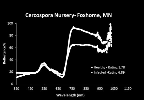
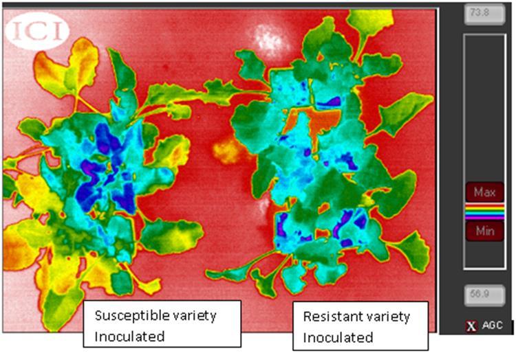
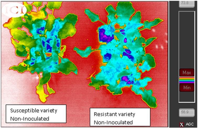

44 Sugarbeet Disease Detection with UAS Rhizoctonia solani infestation Cercospora infestation AIR-AGFO,
45 What Has Gone Well Collaboration: NDSU NP UAS Test Site Elbit - CAP FAA and FCC NDSU County Extension Service Hillsboro Airport Authority Image Quality Objectives: Imagery from 4,000 6,000 8,000 Transfer and Storage of Imagery at NDSU Analyses Nitrogen Management Stand Count Disease Identification Hail Damage Elevation Model


46 Future of UAS in Agriculture Small UAS Plant Stand Count Monitoring and Scouting In-season Fertility Large and Small UAS Digital Elevation Model In-season Fertility AeroDrone Yield Predictions Insect and Disease Movements Identification of Management Issues Yamaha RMAX 8 liters x 2 tanks One More Layer for Big Data Precision Agriculture

47 Book for Technology Early Adopters Innovation and It s Enemies. Why People Resist New Technologies Calestous Juma Moral Values Human Health Environmental Safety Socioeconomic Coffee Printing Press Margarine Farm Mechanization Electricity Refrigeration Recorded Music Transgenic Cops Transgenic Animals
48 Questions - Comments Office Cell John.Nowatzki@ndsu.edu
Drone Technology: What Works for Industry & Landowners. Michael J. Buschermohle Interim Assistant Dean UT Extension
 Drone Technology: What Works for Industry & Landowners Michael J. Buschermohle Interim Assistant Dean UT Extension So You Want to Fly FAA Regulations UAS Platforms Cameras Applications in Forestry Current
Use of Drones (Unmanned Aerial Systems) for Agriculture
 for Agriculture") Photo credit: www.redorbit.com Photo credit: www.redorbit.com Use of Drones (Unmanned Aerial Systems) for Agriculture by Bob Schultheis Natural Resource Engineering Specialist for Ozarks Mini Maker Faire
Photo credit: www.redorbit.com Photo credit: www.redorbit.com Use of Drones (Unmanned Aerial Systems) for Agriculture by Bob Schultheis Natural Resource Engineering Specialist for Ozarks Mini Maker Faire
Unmanned Aerial Systems for Ozarks Agriculture
 Unmanned Aerial Systems for Ozarks Agriculture UAS, UAV, drone Next High Tech Tool for Agriculture and Beyond by Bob Schultheis Natural Resource Engineering Specialist Photo credit: http://modernfarmer.com/2014/01/precision
Unmanned Aerial Systems for Ozarks Agriculture
 Unmanned Aerial Systems for Ozarks Agriculture by Bob Schultheis Natural Resource Engineering Specialist for Webster County Cattle Producers Inc. Marshfield, MO February 11, 2016 1 UAS, UAV, drone Next
UAV/Drone Uses and Laws
 UAV/Drone Uses and Laws Robert Moorhead Director of Geosystems Research and Northern Gulf Institutes Professor of Electrical & Computer Engineering Unmanned Aerial Systems (UASs) 3 components to the system:
Taney County Livestock and Forage Conference Forsyth, MO 2/8/2018
 Photo credit: www.redorbit.com Photo credit: www.redorbit.com Unmanned Aerial Systems (Drones) for Ozarks Agriculture by Bob Schultheis Natural Resource Engineering Specialist for Taney County Livestock
Unmanned Aerial Systems (Drones) for Ozarks Agriculture
 for Ozarks Agriculture") Unmanned Aerial Systems (Drones) for Ozarks Agriculture by Bob Schultheis Natural Resource Engineering Specialist for Taney County Livestock and Forage Conference Forsyth, MO February 8, 2018 1 Farming
Unmanned Aerial Systems (Drones) for Ozarks Agriculture by Bob Schultheis Natural Resource Engineering Specialist for Taney County Livestock and Forage Conference Forsyth, MO February 8, 2018 1 Farming
Coeur d Alene Tribe GIS Unmanned Aerial System (UAS) Program JAMES TWOTEETH BERNE JACKSON GIOVAN ALCALA SABINE KRIER
 Program JAMES TWOTEETH BERNE JACKSON GIOVAN ALCALA SABINE KRIER") Coeur d Alene Tribe GIS Unmanned Aerial System (UAS) Program JAMES TWOTEETH BERNE JACKSON GIOVAN ALCALA SABINE KRIER What is an Unmanned Aerial System (UAS)? Small, unmanned aircraft under 50 lbs. remotely
Coeur d Alene Tribe GIS Unmanned Aerial System (UAS) Program JAMES TWOTEETH BERNE JACKSON GIOVAN ALCALA SABINE KRIER What is an Unmanned Aerial System (UAS)? Small, unmanned aircraft under 50 lbs. remotely
Unmanned Aerial Systems for Agriculture
 Unmanned Aerial Systems for Agriculture by Bob Schultheis Natural Resource Engineering Specialist for Greene County Soils & Crops Conference Springfield, MO March 18, 2014 Special thanks to Bill Wiebold,
Using UAS Technology for Invasive Plant Management
 Using UAS Technology for Invasive Plant Management Adam Benjamin, P.S.M. UF/IFAS Fort Lauderdale R.E.C. May 8, 2018 2018 Aquatic Weed Control Short Course Coral Springs, FL Using UAS Technology for Invasive
FUTURE DRIVEN BY TECHNOLOGY UNMANNED AERIAL SYSTEMS HOSTED BY CHAD E. COLBY FEBRUARY 18 TH How far we have come
 FUTURE DRIVEN BY TECHNOLOGY UNMANNED AERIAL SYSTEMS HOSTED BY CHAD E. COLBY FEBRUARY 18 TH 2015 How far we have come Growers are demanding MORE from every acre, this along with advances in Precision Technology
Development and Testing of an Unmanned Aircraft Safety Beacon for Aerial Application Safety
 Development and Testing of an Unmanned Aircraft Safety Beacon for Aerial Application Safety Wayne Woldt, Ph.D., P.E., and Jacob Smith Biological Systems Engineering and School of Natural Resources University
Program. - Flight Operations (VRI) Motivation. The Aircraft / Sensors. Unmanned Aircraft Systems 8/1/17
 Motivation. The Aircraft / Sensors. Unmanned Aircraft Systems 8/1/17") Program Unmanned Aircraft in Agriculture: Flight Operations and FAA Certification Process * 1) Background. Wayne Woldt, Ph.D., P.E. Department of Biological Systems Engineering School of Natural Resources
Program Unmanned Aircraft in Agriculture: Flight Operations and FAA Certification Process * 1) Background. Wayne Woldt, Ph.D., P.E. Department of Biological Systems Engineering School of Natural Resources
Unmanned Aerial Vehicles for Environmental Applications
 Unmanned Aerial Vehicles for Environmental Applications John Rankin, President, J.R. Canadian Mapping Ltd. 10 th Annual Professional Biology Conference April 23 rd, 2015 UAVs Our System Suitable Sites
OWEA Woolpert UAS Operations
 OWEA 2016 Woolpert UAS Operations UAS Rules and Regulations How Woolpert is Handling This The Exemption In December 2014 Woolpert received approval from the FAA regarding an exemption seeking relief from
What is a UAS (Drone)
") UAS KCSI Aerial Patrol KCSI is Based in Bakersfield CA Established in 1993 Operates in 15 States KCSI has over 20 fulltime pilots Currently fly: Over 40,000 miles of pipeline a month 700 hours of production
UAS KCSI Aerial Patrol KCSI is Based in Bakersfield CA Established in 1993 Operates in 15 States KCSI has over 20 fulltime pilots Currently fly: Over 40,000 miles of pipeline a month 700 hours of production
LAUNCHING YOUR UNMANNED AIRCRAFT PROGRAM
 LAUNCHING YOUR UNMANNED AIRCRAFT PROGRAM THE DARTDRONES TEAM UNMANNED AIRCRAFT APPLICATIONS AERIAL INSPECTIONS AERIAL INSPECTIONS Safer and faster alternative to visual inspection by an individual Damage
Unmanned Aircraft Systems in Disaster Management and National Preparedness
 Unmanned Aircraft Systems in Disaster Management and National Preparedness at the Hawaii Land Surveyors Association Matt Kobayashi Ted Ralston National Disaster Preparedness Training Center Honolulu Why
Lone Star UAS Center. of Excellence and Innovation
 Lone Star UAS Center LSUASC Introduction of Excellence and Innovation Bringing UAS to America s Skies NASAO 85 th Annual Convention and Tradeshow UAS Emerging Technologies & Utilizations September 13,
Use of UAS in Research and Education
 Use of UAS in Research and Education Kelly A. Rusch, Ph.D., P.E. Vice President for Research and Creative Activity-NDSU James L. Grimsley Associate Vice President for Research OU Norman Campus 11/14/16
small Unmanned Aircraft Systems Arlington Police Department June 28, 2011
 suas small Unmanned Aircraft Systems Arlington Police Department June 28, 2011 1. Overview of APD suas program to date 2. Discuss the C.O.A. (FAA certificate of authorization to fly) and restrictions
We're not spying on you; it's more interesting watching grass grow-
 We're not spying on you; it's more interesting watching grass grow- Using Unmanned Aircraft Systems in Rangeland Monitoring Connie Maxwell USDA Agricultural Research Service Jornada Experimental Range
AGAZINE DECEMBER 2015/JANUARY 2016
 M IDWEST FLYER AGAZINE DECEMBER 2015/JANUARY 2016 Published For & By The Midwest Aviation Community Since 1978 midwestflyer.com Unmanned Aircraft Systems Technology Creating New Perspectives That Will
2018 ENGINEERING EXPO Jon Thies NUAIR Director of Consulting
 2018 ENGINEERING EXPO Jon Thies NUAIR Director of Consulting Agenda Operating Under Current FAA Regulations suas Program Development Considerations suas Use Case Examples Quiz Regulations Small Unmanned
DRONES + AIRPORTS: BUZZ AROUND HARTSFIELD-JACKSON
 DRONES + AIRPORTS: BUZZ AROUND HARTSFIELD-JACKSON ACI-NA Legal Affairs Spring Conference Elizabeth Wharton, Senior Asst. City Attorney elizabeth.wharton@atl.com ATL Activities UAS Part 107 Operations contractors,
UAV Program. What does it take to have a UAV Program Current Requirements Lemhi County UAV program
 UAV Program UAV Program What does it take to have a UAV Program Current Requirements Lemhi County UAV program What does it take to have a UAV program? Some Very Important Questions to Ask Before What type
UNMANNED AIRCRAFT SYSTEMS (UAS) IN UTILITIES
 IN UTILITIES") UNMANNED AIRCRAFT SYSTEMS (UAS) IN UTILITIES Presented by: Dan Carbone Avion Unmanned Why Drones? Why Drones? Cost Effective Entire cost of a UAS program can be recouped in first-year man-hour savings
UNMANNED AIRCRAFT SYSTEMS (UAS) IN UTILITIES Presented by: Dan Carbone Avion Unmanned Why Drones? Why Drones? Cost Effective Entire cost of a UAS program can be recouped in first-year man-hour savings
Mapping with Unmanned Airborne Systems (UAS)
") Mapping with Unmanned Airborne Systems (UAS) February 13, 2014 Engineering Architecture Design-Build Surveying GeoSpatial Solutions Today s Agenda Introductions / Objectives Current UAS Regulations (FAA)
Mapping with Unmanned Airborne Systems (UAS) February 13, 2014 Engineering Architecture Design-Build Surveying GeoSpatial Solutions Today s Agenda Introductions / Objectives Current UAS Regulations (FAA)
fll,' The University of Georgia O tfo:c o f rh.: Vu:.: Pre,id.:nt for Research
 November 30, 2015 fll,' - - - ----- I M.$------- The University of Georgia ------------------9 O tfo:c o f rh.: Vu:.: Pre,id.:nt for Research U.S. Department of Transportation Docket Management System
The role of Unmanned Aircraft System (AUS) in search and rescue (SAR) operations
 in search and rescue (SAR) operations") The role of Unmanned Aircraft System (AUS) in search and rescue (SAR) operations Captain: Abdelkhalik Kamaleldin Soliman Selmy College of Maritime Transport & Technology Arab Academy for Science, Technology
The role of Unmanned Aircraft System (AUS) in search and rescue (SAR) operations Captain: Abdelkhalik Kamaleldin Soliman Selmy College of Maritime Transport & Technology Arab Academy for Science, Technology
Commercial UAS & the Impact of State Regulations Southern Legislative Conference July 20, 2015
 Commercial UAS & the Impact of State Regulations Southern Legislative Conference July 20, 2015 * Meet Ben 01 Currently the CEO of AgriSource Data; he was formerly the COO of VSG- Unmanned & has held leadership
Unmanned Aircraft Systems (UAS) at the Jornada Experimental Range
 at the Jornada Experimental Range") Unmanned Aircraft Systems (UAS) at the Jornada Experimental Range Al Rango and the Jornada UAS Flight Team: Connie Maxwell, Amy Slaughter, Andrea Laliberte, Chris Pierce, Dave Thatcher, Jim Lenz, and Craig
Unmanned Aircraft Systems (UAS) at the Jornada Experimental Range Al Rango and the Jornada UAS Flight Team: Connie Maxwell, Amy Slaughter, Andrea Laliberte, Chris Pierce, Dave Thatcher, Jim Lenz, and Craig
Getting off the Ground: Implementing a Drone Program
 Getting off the Ground: Implementing a Drone Program November 2017 Steve Goldman, GISP GIS Manager / UAS Coordinator California Department of Fish and Wildlife http://www.wildlife.ca.gov Drones (UAS) What
UAS Unmanned Aircra: Systems in Forest Management
 UAS Unmanned Aircra: Systems in Forest Management UAS What are they? Unmanned Aircra: Systems (UAS) fill niche built upon military UAV technologies Most common plahorms Fixed Wing Rotorcra: Primary uses
How to Use Drones in Stormwater Management January 17, :30 a.m. 11:30 a.m. (Eastern)
") Webinar Training Series How to Use Drones in Stormwater Management January 17, 2019 10:30 a.m. 11:30 a.m. (Eastern) www.seswa.org Today s Presenters Robert Gecy Application Programmer Beaufort County,
Webinar Training Series How to Use Drones in Stormwater Management January 17, 2019 10:30 a.m. 11:30 a.m. (Eastern) www.seswa.org Today s Presenters Robert Gecy Application Programmer Beaufort County,
Unmanned Aircraft Systems (UAS): A Paradigm Shift in Aviation
: A Paradigm Shift in Aviation") Unmanned Aircraft Systems (UAS): A Paradigm Shift in Aviation Tom Haritos, Ed.S. Department of Aeronautical Science Embry-Riddle Aeronautical University Florida Airports Council (FAC) 2015 1 The trouble
Unmanned Aircraft Systems (UAS): A Paradigm Shift in Aviation Tom Haritos, Ed.S. Department of Aeronautical Science Embry-Riddle Aeronautical University Florida Airports Council (FAC) 2015 1 The trouble
Aeros 40D Sky Dragon. TYPE CERTIFIED BY: United States Federal Aviation Administration Civil Aviation Authorities: Europe and Asia
 Aeros 40D Sky Dragon The Aeros 40D Sky Dragon Airship The United States Federal Aviation Administration (FAA) Type Certified Aeros 40D Sky Dragon is the most advanced non rigid airship, incorporating innovative
A Drone s Eye View on Public Works Applications
 A Drone s Eye View on Public Works Applications APWA Construction Inspection Conference Parker, CO Jason Caldwell, VP of Business Development and Sales 2013, The Sanborn Map Company, Inc. Agenda Sanborn
Commit to Safety: Professional Pilots Always Use a Checklist INITIAL EQUIPMENT SETUP
 Commit to Safety: Professional Pilots Always Use a Checklist INITIAL EQUIPMENT SETUP READ THE MANUAL Familiarize yourself with all aspects of your suas before you even consider going out for your first
Adventures in UAS: Experiences of a UAS Operator. Paul Beckwith, PE, CCM, LEED AP bd+c Navigator CS, LLC, President. Presented by:
 Adventures in UAS: Experiences of a UAS Operator Presented by: Paul Beckwith, PE, CCM, LEED AP bd+c Navigator CS, LLC, President Paul Beckwith, PE, CCM, LEED AP bd+c BA in Architectural Engineering from
uas.usgs.gov Michael E. Hutt & Jeff L. Sloan USGS-Rocky Mountain Geographic Science Center UAS National Project Office Denver, Colorado
 uas.usgs.gov Michael E. Hutt & Jeff L. Sloan USGS-Rocky Mountain Geographic Science Center UAS National Project Office Denver, Colorado USGS Land Remote Sensing Program Emerging Technology Investigation
WEBINAR: A BIRD S-EYE VIEW
 WEBINAR: A BIRD S-EYE VIEW DRONES IN AGRIBUSINESS JUNE 21, 2016 Hosted by Nexsen Pruet Presented by Ernie Pearson (Nexsen Pruet); Patrick Lohman (PrecisionHawk); and Kyle Snyder (NGAT/NCSU) FOUNDED IN
ONE PLATFORM, MULTIPLE APPLICATIONS: SURVEYING CONSTRUCTION FORESTRY AGRICULTURE ENVIRONMENT POWER ENGINEERING BIRDIE YOUR TAILOR-MADE UAV
 UAV BIRDIE BIRDIE YOUR TAILOR-MADE UAV ONE PLATFORM, MULTIPLE APPLICATIONS: SURVEYING CONSTRUCTION FORESTRY AGRICULTURE ENVIRONMENT POWER ENGINEERING BIRDIE UAV is the complete mapping solution, made for
2017 PLSO Fall Seminar. UAV s Flying to Finished Product
 2017 PLSO Fall Seminar UAV s Flying to Finished Product Scott D. Kraner, P.E. Subject Matter Expert Civil Infrastructure Session Outline UAV Overview and Applications How to obtain a remote pilot certificate?
The Legal Environment for Commercial Unmanned Aircraft
 The Legal Environment for Commercial Unmanned Aircraft Overview The Legal Environment Who can fly them? A history of FAA policy to the present Asking for permission 2 Today s Legal Framework 3 Today s
GEOMATIC ASSESSMENT Membership Directory & Buyers Guide 97th Annual Conference Recap WINTER 2017/18
 WINTER 2017/18 GEOMATIC NC AWWA-WEA 3725 National Drive, Suite 217 Raleigh, NC 27612 ADDRESS SERVICE REQUESTED 2018 Membership Directory & Buyers Guide 97th Annual Conference Recap The official publication
Planning for RPAS Operations
 Planning for RPAS Operations Tom Wade, Facility Manager, University of Edinburgh Image courtesy of Simon Gibson-Poole (UoE/SRUC) at Introduction Terminology Strengths and Limitations is this the tool for
UAS Regulations and Usage. July 14, 2016 Presenter: David Day, CP, GISP Keystone Aerial Surveys, Inc.
 UAS Regulations and Usage July 14, 2016 Presenter: David Day, CP, GISP Keystone Aerial Surveys, Inc. Keystone Aerial Surveys, Inc. Based in Philadelphia, PA with offices in Los Angeles, Tucson and Tyler,
Why Ohio? Research and Development: Test Infrastructure: Expertise and Workforce:
 Ohio UAS Center Strategic Plan 2019 Why Ohio? Ohio has a rich history of aviation going back to the days when the Wright Brothers first pioneered flight in 1903. Today, Ohio remains a national leader in
Presentation: UAS Helicopter Waran -1-
 Presentation: UAS Helicopter Waran -1- The unique design features of the Waran provide a superior payload capacity, prolonged endurance, stable flight patterns and a high degree of safety features. Technical
UAV systems for cultural heritage HERICT ERASMUS IP Technical lecture 2
 UAV systems for cultural heritage HERICT ERASMUS IP Technical lecture 2 Dr. Dimitrios Skarlatos Lecturer Cyprus university of Technology Photogrammetric Vision Lab Dept. of Civil Eng. & Geomatics Dipl.
Net of Innovation. July 2015 Dave Finger, Mark Foster
 Net of Innovation July 2015 Dave Finger, Mark Foster Table of Contents The Challenges and Solutions to Safe Outdoor Testing... 2 Types of Testing a Netted Enclosure Enables... 4 Flight Plan Testing...
 Presented by: Lt. Michael J. Magda Team Leader, Firefighter, EMT -P, Hazardous Material Specialist, Private Pilot, Airframe & Power plant Mechanic Western Wayne County HMRT, Livonia Fire & Rescue And
Unmanned Aircraft Systems (UAS) 101
 101") Unmanned Aircraft Systems (UAS) 101 Presented to: ACC Airports Technical Workshop Presented by: David Russell, Program Analyst, UAS Integration Office, Date: August 10, 2016 Overview Unmanned Aircraft
Unmanned Aircraft Systems (UAS) 101 Presented to: ACC Airports Technical Workshop Presented by: David Russell, Program Analyst, UAS Integration Office, Date: August 10, 2016 Overview Unmanned Aircraft
th Ave. SW I Minot, ND, I
 1020 20 th Ave. SW I Minot, ND, 58701 www.minotusa.com I 701.852.1075 MAGIC Sky Initiative White Paper Introduction The Unmanned Aerial Systems (UAS) industry is an emerging industry that has experienced
Light UAS for forestry applications an Operational experience
 Light UAS for forestry applications an Operational experience European High Level Unmanned Aircraft Systems (UAS) Conferencen Lars Björk Swedish Forest Agency 1 Swedish Forest Agency Swedish Forest Agency
Unmanned Aircraft Systems (UAS) 101
 101") Unmanned Aircraft Systems (UAS) 101 Presented to: National Tribal Transportation Conference Presented by: Robert Winn, Aviation Safety Inspector, Unmanned Aircraft Systems Office Date: Overview Unmanned
Unmanned Aircraft Systems (UAS) 101 Presented to: National Tribal Transportation Conference Presented by: Robert Winn, Aviation Safety Inspector, Unmanned Aircraft Systems Office Date: Overview Unmanned
Using UAVs for Aerial Mapping, Surveying and Photography
 Using UAVs for Aerial Mapping, Surveying and Photography Prepared for: Central Florida GIS Workshop 18 September 2013 Kevin Shortelle System Dynamics International, Inc kevinshortelle@bellsouth.net Presentation
Questions to Answer: The Rules. Unmanned Aerial Systems (UAS): What You Need to Know. 1. Should we be leveraging UAS?
: What You Need to Know. 1. Should we be leveraging UAS?") Unmanned Aerial Systems (UAS): What You Need to Know Colorado SWANA Annual Conference September 13, 2017 Questions to Answer: 1. Should we be leveraging UAS? 2. Should we self-perform UAS work? 3. If we
Unmanned Aerial Systems (UAS): What You Need to Know Colorado SWANA Annual Conference September 13, 2017 Questions to Answer: 1. Should we be leveraging UAS? 2. Should we self-perform UAS work? 3. If we
UAS Integration Activities
 UAS Integration Activities Presented to: Presented by: Ian Ross Senior Representative/Attaché Date: Meeting the Challenge Industry Volume & Pace Personal Nature of UAS Shared Commitment to Safety The Path
Definitions. U-SAFE : UAS Secure Autonomous Flight Environment. UTM: UAS Traffic Management
 Definitions U-SAFE : UAS Secure Autonomous Flight Environment UTM: UAS Traffic Management NUSTAR: National UAS Standardized Test and Rating 2 U-SAFE Award Dec 11, 2015 Signature Initiative in Central New
Platform and Products
 International Partnership Space Programme Earth Observation for the Preservation of Ecological Bacalar Corridor Platform and Products Terri Freemantle, Raffaella Guida, Paula Marti, Pasquale Iervolino
Cal UAS Portal. Eileen Shibley UAS Lead, Inyokern Airport
 Cal UAS Portal Eileen Shibley UAS Lead, Inyokern Airport eshibley@me.com 760-382-1049 Commercial Airline Traffic IYK *NASA Ames Image *NASA Ames Image R-2508 Complex Drone, UAV, UAS, RPV, RPA, Air Robot?
Unmanned Aircraft Systems (UAS) 101
 101") Unmanned Aircraft Systems (UAS) 101 Presented to: The American Association of State Highway and Transportation Officials Presented by: Dave May, FAA UAS Integration Office Date: What is a UAS? A UAS is
Unmanned Aircraft Systems (UAS) 101 Presented to: The American Association of State Highway and Transportation Officials Presented by: Dave May, FAA UAS Integration Office Date: What is a UAS? A UAS is
NEVADA FAA UAS TEST SITE QUARTERLY REPORT
 NEVADA FAA UAS TEST SITE QUARTERLY REPORT December 30, 2016 4 th Quarter, CY16 Submitted in accordance with Other Transactional Agreement DTFACT-14A-00003 Prepared by: Nevada Institute for Autonomous Systems
U.S. Forest Service Explores Use of UAS In Fire Management Jennifer Jones Public Affairs Specialist Washington Office, Fire and Aviation Management
 U.S. Forest Service Explores Use of UAS In Fire Management Jennifer Jones Public Affairs Specialist Washington Office, Fire and Aviation Management On August 27, 2013, an unusual resource order was placed
Unmanned Aircraft Systems (UAS) 101
 101") Unmanned Aircraft Systems (UAS) 101 Presented to: AUVSI Cascade Chapter Future Robotics Forum Presented by: Michael Dement-Myers, (FAA), NextGen Branch Date: October 20, 2016 Overview Unmanned Aircraft
Unmanned Aircraft Systems (UAS) 101 Presented to: AUVSI Cascade Chapter Future Robotics Forum Presented by: Michael Dement-Myers, (FAA), NextGen Branch Date: October 20, 2016 Overview Unmanned Aircraft
Unmanned Aerial Vehicles or How I learned to stop worrying and love drones!
 Unmanned Aerial Vehicles or How I learned to stop worrying and love drones! Dr. Charles O Neill Aerospace Engineer, UA Professor, Pilot charles-oneill.com or aero.ua.edu Brief History of Drones German
Space Based ADS-B. ICAO SAT meeting - June 2016 AIREON LLC PROPRIETARY INFORMATION
 Space Based ADS-B ICAO SAT meeting - June 2016 1 Options to Detect an Aircraft Position Position Accuracy / Update Interval Voice Position Reporting ADS-C Position Reporting Radar Surveillance / MLAT Space
Sam Houston State University UAS Use Checklist
 Sam Houston State University UAS Use Checklist The FAA Part 107 of the Code of Federal Regulations and the Sam Houston State University President s Office Policy PRE-27 determine the minimum requirements
NASA s Automatic Dependent Surveillance Broadcast: ADS-B Sense-and-Avoid System
 NASA s Automatic Dependent Surveillance Broadcast: ADS-B Sense-and-Avoid System October 30, 2014 Ricardo Arteaga NASA Armstrong Flight Research Center is a world class leader in cutting-edge Systems Engineer
P310 VTOL UAV Operation Manual
 P310 VTOL UAV Operation Manual February, 2017 1 Shanghai Huace Navigation Technology Ltd. Contents 1.1 SYMBOLS DEFINITIONS... 4 1.2 TECHNICAL SUPPORT... 5 2.1 WARNING... 5 2.2 NOTICE... 5 4.1 GENERAL SPECIFICATIONS...
Needs for UAS in Response
 UAS Potential Uses and Limitations October 21, 2015 Michele Jacobi Office Response and Restoration 10/27/2015 1 Needs for UAS in Response Limited access to areas of interest (distance, safety concerns,
Enabling Civilian Low-Altitude Airspace and Unmanned Aerial System (UAS) Operations. Unmanned Aerial System Traffic Management (UTM)
 Operations. Unmanned Aerial System Traffic Management (UTM)") Enabling Civilian Low-Altitude Airspace and Unmanned Aerial System (UAS) Operations By Unmanned Aerial System Traffic Management (UTM) Parimal Kopardekar, Ph.D. UTM Principal Investigator and Manager,
Enabling Civilian Low-Altitude Airspace and Unmanned Aerial System (UAS) Operations By Unmanned Aerial System Traffic Management (UTM) Parimal Kopardekar, Ph.D. UTM Principal Investigator and Manager,
National Technology Project OUTCAST. M. Selier R&D Engineer Military Operations Research Department
 National Technology Project OUTCAST M. Selier R&D Engineer Military Operations Research Department Nationaal Lucht- en Ruimtevaartlaboratorium National Aerospace Laboratory NLR The Dutch and UAS? Since
Unmanned Aircraft Systems (UAS)
") Unmanned Aircraft Systems (UAS) Update Presented to: Airports Council International Presented by: Danielle J. Rinsler, AICP Date: Who is Operating UAS in the National Airspace System (NAS)?* Public (Governmental)
Unmanned Aircraft Systems (UAS) Update Presented to: Airports Council International Presented by: Danielle J. Rinsler, AICP Date: Who is Operating UAS in the National Airspace System (NAS)?* Public (Governmental)
Using Geospatial Data in the Oil & Gas Industry. Dr. Stacey D. Lyle, RPLS
 Using Geospatial Data in the Oil & Gas Industry Dr. Stacey D. Lyle, RPLS Outcomes A Geospatial Data Science Center is an advanced database of information organized and accessible using multiple software
Systems (UAS) Unmanned Aircraft. Presented to: GWBAA Safety Stand Down Day. Presented by: John Meehan. Date: 17 May AUS-430 Safety & Operations
 Unmanned Aircraft. Presented to: GWBAA Safety Stand Down Day. Presented by: John Meehan. Date: 17 May AUS-430 Safety & Operations") Unmanned Aircraft Systems (UAS) Presented to: GWBAA Safety Stand Down Day Presented by: John Meehan AUS-430 Safety & Operations UAS Integration Office Date: What is a UAS? Unmanned aircraft system (UAS)
Unmanned Aircraft Systems (UAS) Presented to: GWBAA Safety Stand Down Day Presented by: John Meehan AUS-430 Safety & Operations UAS Integration Office Date: What is a UAS? Unmanned aircraft system (UAS)
For Military & Domestic Testing, Training, & Operations. Briefing for the Mid America Defense Conference Wednesday, October 31st, 2012
 For Military & Domestic Testing, Training, & Operations Briefing for the Mid America Defense Conference Wednesday, October 31st, 2012 BG Jeffrey Hauser, Assistant Adjutant General for Air, State of Indiana
small Unmanned Aerial Systems (suas)
") 2018 WSC Annual Safety Conference small Unmanned Aerial Systems (suas) Presenter Introduction Chris Seider, CSP, PHR, CHST, ARM Senior Safety and Risk Management Specialist Foth & Van Dyke, LLC Chris.Seider@Foth.com
2018 WSC Annual Safety Conference small Unmanned Aerial Systems (suas) Presenter Introduction Chris Seider, CSP, PHR, CHST, ARM Senior Safety and Risk Management Specialist Foth & Van Dyke, LLC Chris.Seider@Foth.com
Bob Wick Wilderness Specialist Washington Office UAS and Wilderness June 2017
 Bob Wick Wilderness Specialist Washington Office rwick@blm.gov UAS and Wilderness June 2017 FAA has jurisdiction over airspace Land mgmt. agencies regulate takeoff/landing and ground-based human control
th Ave. SW I Minot, ND, I
 1020 20 th Ave. SW I Minot, ND, 58701 www.minotusa.com I 701.852.1075 MAGIC Sky Initiative White Paper Introduction The Unmanned Aerial Systems (UAS) industry is an emerging industry that has experienced
Integrated Applications Programme (IAP) & Space for UAS UAS for Applications
 & Space for UAS UAS for Applications") ESA s Integrated Applications Programme (IAP) & Space for UAS UAS for Applications M. Vaissiere ESA Director of Telecommunications and Integrated Applications Programme European High Level UAS Conference
ESA s Integrated Applications Programme (IAP) & Space for UAS UAS for Applications M. Vaissiere ESA Director of Telecommunications and Integrated Applications Programme European High Level UAS Conference
Re: Exemption Request Section 333 of the FAA Reform Act and Part 11 of the Federal Aviation Regulations
 September 04, 2014 U. S. Department of Transportation Docket Management System 1200 New Jersey Ave., SE Washington, DC 20590 Re: Exemption Request Section 333 of the FAA Reform Act and Part 11 of the Federal
UAS Program. Todd Graetz Director, Technology Services UAS Program / Advanced Train Operations 1
 UAS Program Todd Graetz Director, Technology Services UAS Program / Advanced Train Operations 1 The elements of the program Business requirements Line of Sight (LOS) Implementation Applications Data/product
PRO LINE FUSION INTEGRATED AVIONICS SYSTEM. Pro Line Fusion on Gulfstream G280: Your direct path to see and access more.
 Pro Line Fusion on Gulfstream G280: Your direct path to see and access more. Starting with its baseline features, the Pro Line Fusion avionics in your Gulfstream PlaneView280 flight deck offer capabilities
UNMANNED AIRCRAFT SYSTEMS (UAS) FOR PUBLIC POWER OPERATIONS AN OVERVIEW ON HOW DRONES ARE IMPACTING THE ENERGY INDUSTRY
 FOR PUBLIC POWER OPERATIONS AN OVERVIEW ON HOW DRONES ARE IMPACTING THE ENERGY INDUSTRY") UNMANNED AIRCRAFT SYSTEMS (UAS) FOR PUBLIC POWER OPERATIONS AN OVERVIEW ON HOW DRONES ARE IMPACTING THE ENERGY INDUSTRY ABOUT CHRISTOPHER TODD Founder and president of Airborne Response, Miamibased UAS
UNMANNED AIRCRAFT SYSTEMS (UAS) FOR PUBLIC POWER OPERATIONS AN OVERVIEW ON HOW DRONES ARE IMPACTING THE ENERGY INDUSTRY ABOUT CHRISTOPHER TODD Founder and president of Airborne Response, Miamibased UAS
NEW JERSEY COUNTIES EXCESS JOINT INSURANCE FUND 9 Campus Drive, Suite 216 Parsippany, NJ Telephone (201) BULLETIN NJCE 19-04
 BULLETIN NJCE 19-04") Date: January 1, 2019 NEW JERSEY COUNTIES EXCESS JOINT INSURANCE FUND 9 Campus Drive, Suite 216 Parsippany, NJ 07054 Telephone (201) 881-7632 BULLETIN NJCE 19-04 To: From: Re: Fund Commissioners of NJCE
Date: January 1, 2019 NEW JERSEY COUNTIES EXCESS JOINT INSURANCE FUND 9 Campus Drive, Suite 216 Parsippany, NJ 07054 Telephone (201) 881-7632 BULLETIN NJCE 19-04 To: From: Re: Fund Commissioners of NJCE
UNMANNED AERIAL SYSTEM (UAS) POLICY
 POLICY") UNMANNED AERIAL SYSTEM (UAS) POLICY Colby College 5500 Mayflower Hill, Waterville, ME 04901 REVISION HISTORY The UAS Policy will be reviewed and revised annually by the EHS Director. Additional revisions
UNMANNED AERIAL SYSTEM (UAS) POLICY Colby College 5500 Mayflower Hill, Waterville, ME 04901 REVISION HISTORY The UAS Policy will be reviewed and revised annually by the EHS Director. Additional revisions
a. Aeronautical charts DID THIS IN LESSON 2
 AIRMAN CERTIFICATION STANDARDS: REMOTE PILOT SMALL: You will know and be able to explain in writing or oral form the below tasks regarding AIRPORT OPERATIONS Task References Objective Task B. Airport Operations
UAS Overview IDOT s UAS Program
 Unmanned Aircraft Systems (UAS) UAS Overview IDOT s UAS Program Linda Schumm Bureau Chief Aviation Safety Linda.Schumm@Illinois.gov October 18, 2017 Bill Viste Project Coordinator William.Viste@Illinois.gov
Airborne Remote Sensing Component of Marine Debris Monitoring
 Airborne Remote Sensing Component of Marine Debris Monitoring Dr. Thomas H Mace Mace Geospatial, LLC Workshop on Mission Concepts for Marine Debris Sensing Honolulu, Hi, Jan 19 21, 2016 Multistage Remote
DEFINITIONS DEFINITIONS 2/11/2017 REQUIREMENTS AND LIMITATIONS OF DRONE USE IN FORENSIC ACCIDENT RECONSTRUCTION
 REQUIREMENTS AND LIMITATIONS OF DRONE USE IN FORENSIC ACCIDENT RECONSTRUCTION ROGER BURGMEIER BURGMEIER CONSULTING INC. DEFINITIONS Aircraft: device that is used, or intended to be used, for flight. Drone:
The American Institute of Aeronautics and Astronautics
 The American Institute of Aeronautics and Astronautics Civilian Applications of UAVs A California Perspective, a Policy Symposium Michael Toscano President & CEO Association for Unmanned Vehicle Systems
Fly at the speed of ingenuity on your Learjet 85
 rockwell collins Pro Line Fusion Avionics Fly at the speed of ingenuity on your Learjet 85 Image courtesy of Bombardier. Experience the most advanced avionics system ever offered on a mid-size jet. Achieve
PREPARED STATEMENT OF BRIAN WYNNE PRESIDENT AND CEO, ASSOCIATION FOR UNMANNED VEHICLE SYSTEMS INTERNATIONAL
 PREPARED STATEMENT OF BRIAN WYNNE PRESIDENT AND CEO, ASSOCIATION FOR UNMANNED VEHICLE SYSTEMS INTERNATIONAL U.S. Senate Committee on Commerce, Science & Transportation Subcommittee on Aviation Operations,
Drones, Robots and Public Safety
 Drones, Robots and Public Safety IWCE Thursday, March 30, 2017 11:30 am - 12:45 pm Room: S230 Session Number: TH12 The member organizations of the National Public Safety Telecommunications Council are
Hidalgo County Drone Program. Standard Operating Procedure (SOP) Template. February 23, 2017
 Template. February 23, 2017") Hidalgo County Drone Program Standard Operating Procedure (SOP) Template The following is a detailed (but intended as a comprehensive) framework of topics to be covered in a Standard Operating Procedure
Hidalgo County Drone Program Standard Operating Procedure (SOP) Template The following is a detailed (but intended as a comprehensive) framework of topics to be covered in a Standard Operating Procedure
What Can Drones Do For Me?
 Event Type: Drones (Unmanned Aircraft Systems [UAS]) Date: August 1-24, 2018 Location: Taylor Creek/Klondike Fire 10 miles west of Grants Pass, Oregon Another Drone Success Story It was 3 a.m. I had 34
CHC P310 Operation Procedure
 CHC P310 Operation Procedure 1. GCS-202 Ground Control System Preparation a. Fix the location of GCS-202 b. Power on the GCS-202 and wait for the DGPS signal lock-in. Note: 1. if external power supply