Coeur d Alene Tribe GIS Unmanned Aerial System (UAS) Program JAMES TWOTEETH BERNE JACKSON GIOVAN ALCALA SABINE KRIER
|
|
|
- Bonnie Blake
- 5 years ago
- Views:
Transcription
1 Coeur d Alene Tribe GIS Unmanned Aerial System (UAS) Program JAMES TWOTEETH BERNE JACKSON GIOVAN ALCALA SABINE KRIER
2 What is an Unmanned Aerial System (UAS)? Small, unmanned aircraft under 50 lbs. remotely piloted/programmed from ground control stations (computers) Rotary flight system with 3 or more propellers flown like a helicopter in hover mode quad-copter, hexa-copter, octa-copter Manufacturers: DJI, GoPro, Hubsan, Intel, YUNEEC, FREEFLY, Parrot, many others Fixed-wing, hand or catapult launched, typically with a single propeller flown like an airplane, but may have multiple motors and propellers with VTOL (Vertical Take Off and Landing) capabilities Manufacturers: Trimble, Honeycomb, UASUSA, Parrot, Birdseyeview Aerobotics, Altavian, QuestUAV, PrecisionHawk, QuantumSystems, DroneAmerica many others aka, Unmanned Aerial Vehicles (UAV), Drones


3 About our Land The 350,000-acre Coeur d'alene Reservation is located in Northern Idaho. It includes the southern portion of Lake Coeur d Alene, the lower end of the St. Joe River and many other creeks and wetlands. The eastern side of the reservation is mostly conifer covered mountains maintained by an active timber industry. The western part includes four small towns, but is otherwise mainly dry-land agricultural. The Tribe manages a large portion of this land through their Natural Resources, Lake Management, Land Services and Public Works Departments. These departments were excited about the new possibilities opening up with a UAS program. Lake Coeur d Alene and Coeur d Alene and St. Joe rivers are the heart of the Coeur d Alene Tribe. It is where Tribal members go for ceremony, food, transportation and recreation. The Lake and its surrounding waters have always held great spiritual significance for Tribal members. The tragic effects of over a century of North Idaho Silver Valley mining are still having effects on the entire Coeur d Alene Basin ecosystem. Mining sites toxic by products run into the streams, rivers, and wetlands, and ultimately into the Lake itself.


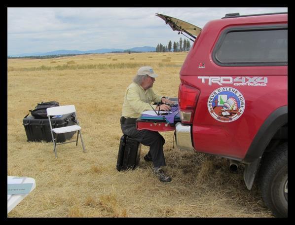
4 Coeur d Alene Tribe GIS Staff: Top: James Twoteeth, Berne Jackson Bottom: Sabine Krier, Giovan Alcala Career Day at the local High School


5 What launched our interest in acquiring a UAS? Need for higher resolution imagery; custom flown imagery is very expensive to fly Maturation of the UAS industry with models capable of long flights with heavier payloads The capability of flying areas multiple times of the year The ability to easily change imagers depending on the imagery requirements Grant monies becoming available
 UAS s had very limited flight times (around 15 minutes).")
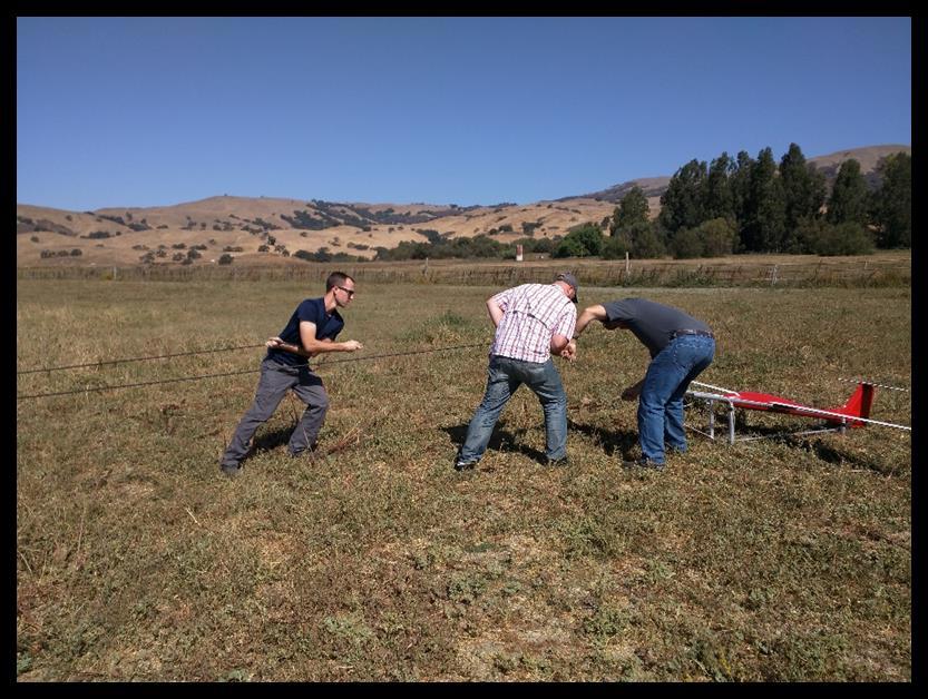
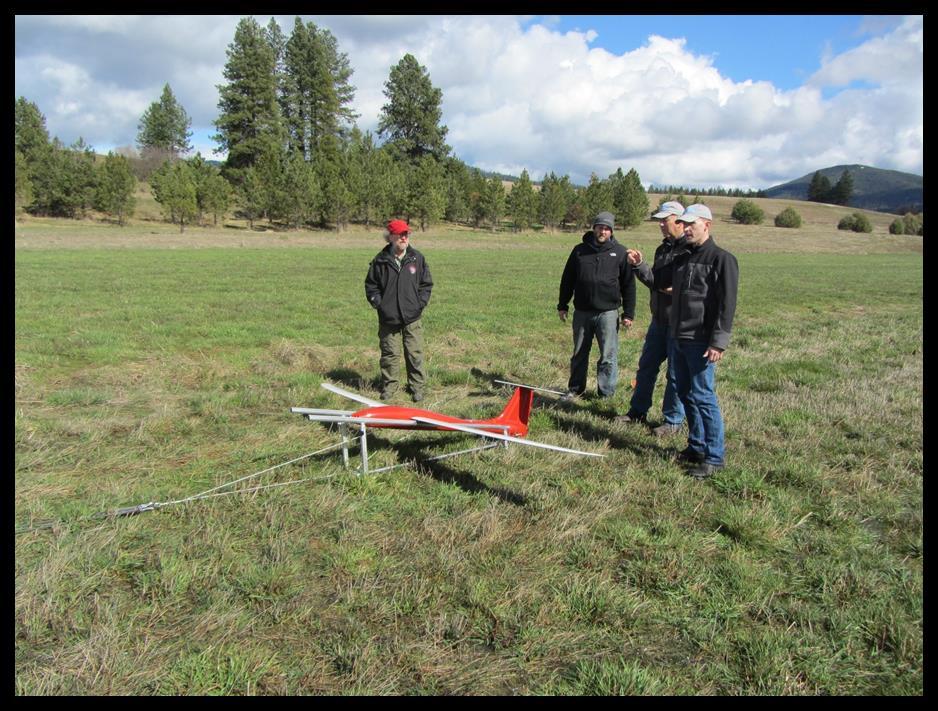
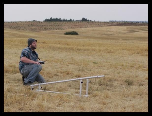
6 Selection criteria considered It was impossible to find a small UAS capable of imaging the amount of acreage we need to fly. We wanted the ability to fly as many acres as possible and still stay within the FAA line-of-sight contact rule. Rotary-style ( quad-copter ) UAS s had very limited flight times (around 15 minutes). Fixed-wing UAS s only had a single motor and often had large wing-spans making them very energy efficient in the air. These types of UAS s could remain aloft for up to 90 minutes increasing their acreage coverage dramatically. The larger of these could also carry more payload increasing the versatility of the aircraft. The UASUSA Tempest was the finalist in the Tribe s selection process. It had a wingspan of 9 feet and could carry about 7 pounds for well over an hour on a single battery. This gave the capability of acquiring imagery on close to 600 acres per flight gathering both RGB and near-infrared imagery simultaneously.

7 Acquisition of the Aero Systems West X8 During Coeur d Alene Tribe GIS s flight training with their Tempest conducted by Aero Systems West (ASW) in Morgan Hill, California, they realized that using the Tempest for training was not the best use of its time. ASW offered to sell one of its relatively inexpensive used foam UAS s, the X8, to the Tribe to use as a trainer. It uses the same autopilot and flight software as the Tempest. So operationally, it is very similar to the Tempest. In the event of a hard landing, its foam airframe is relatively inexpensive to replace (available at Walmart!) and by swapping the internal components, it can quickly be back in service. We use it for improving our fly-by-wire skills, in particular our landing approaches, a vital maneuver in some emergencies.


8 Legal Preparations We knew we had to comply with the FAA regulations. For commercial UAV use, we would have to apply for a Section 333 exempt form to fly our UAS on the Reservation, but during the filling process, we found out that the FAA Part 107 UAS rules had just been released eliminating the need for the 333 exemption. North Idaho College in Coeur d Alene offered approved inclassroom training for the FAA test. We signed up, took the course and passed our FAA exams, and are now licensed small UAS remote pilots. On the FAA UAS website, we could quickly register our new UAS and then proudly place the serial number on it. The last step was insure the UAS and all sensors with an insurance company specializing in UAS s.
 aircraft flying, thus, we had to have training in using the Mission Planner software that is")


9 Training and planning a Mission So what all does it take to get flying and to capture the data we are looking for? We did not have a background in Remote Control (RC) aircraft flying, thus, we had to have training in using the Mission Planner software that is used by the autopilot. This tells the autopilot how the UAS will take off, land and grid collection areas. We had to learn how to conduct maintenance on the UAS and all related equipment. We needed a way to process the UAS s images. We knew about Pix4D, but, we already have the suite of ESRI products. Knowing that ESRI s Drone2Map uses the Pix4D engine under the hood, we were confident this software would be adequate for our processing needs. ESRI support has helped us along the way and we have been able to generate high quality and understandable data that we can now share on our Portal for ArcGIS in a web application.
10 What We Can Do Currently/Long Term Fly as often as needed Agriculture Determine study areas Forestry or crop monitoring multiple times of the year Archaeology Stream/River bank Restoration (Hangman Creek) Crop health (disease) Harvest yield prediction vs. what makes it to the elevators (compare) Pest control Erosion over time (St. Joe River Timber sale Health (Beetle or other tree disease) Stand examine (sample plots) Tree counts / Fire safety (brush) Fertilizer optimization Improve efficienciy to farm marginal areas Animal tracking (thermal) Fly on cloudy day = better analysis of species Lake monitoring temperature (thermal)


11 Processing the Data We would love to just go out and fly every day weather permitting and obtain imagery. Nevertheless, we need to be able to process all that imagery and have a usable end product. We did research and discussed the different available image processing software packages with others who had experience. Using a free trial version of Pix4D seemed showed us a very capable software option, but seemed overly difficult to learn, so we decided on Drone2Map, an ESRI software available to us and more easy to learn and use. It seemed natural since we already use many other ESRI products like ArcGIS Desktop, Server, Portal and several field apps. Processing with Drone2Map is quite easy once you have flight logs to assign coordinates to the images. We learned that you need a very powerful computer to process the many images from a flight. It takes time; 580 acres of RGB imagery took the most capable workstation we had over 24 hours. The program may have difficulty with some flights imagery, but ESRI support can walk you through those issues. Drone2Map will show 2D and 3D views of the finished data, and end products such as mosaicked ortho-imagery, NDVI, Digital Surface Models (DSM) and Digital Elevation Models (DEM). The final full Drone2Map report shows everything about the data and how to perfect our data collection procedures.

12 EPA Grant and Acquisition of Hyperspectral Sensor Recently we were awarded an EPA Environmental Network Exchange grant. Our goal is to research, evaluate and map our many wetlands, streams and lakes and the impact of heavy metals, a by-product of the mining industries in the Silver Valley. With the help of this grant we are able to purchase our third UAS, a DJI M600. It is a rotary-style model with which we will be able to fly in tighter spaces like forest stands and over water. It will be equipped with a Headwall Nano Hyperspec hyperspectral sensor.

13 Hyperspectral Data Collection Remote sensing techniques have the ability to identify soil properties for both environmental and agricultural purposes. Hyperspectral sensor data has been used for over a decade to help researchers detect chemicals and heavy metals. For future decision-making, targeted cleanup and on-going maintenance and rehabilitation efforts in our wetland areas, the hyperspectral sensor attached to the DJI M600 UAS can scan large sections to determine where runoff starts and where contaminated areas are located. The hyperspectral sensor collect vast amounts of images per flight. This would quickly fill the Tribe s current storage capabilities. To meet the demand of the incoming sensor data we had to acquire a higher storage capacity server and tape libraries.

14
15 Launching!


16 3D Imagery captured with the Tempest Hillshade produced from a DEM captured with the Tempest s Sony A6000 RGB sensor
17 Lessons Learned and Words of Advice You must be committed to creating a UAS program and have the need for the product it can produce. It s not about the flying; it s about data acquisition. Be patient. This will be a long and arduous process. And needless to say, it will be very expensive. Selection of a vendor is difficult. Many of these companies are young and going through growing pains of their own. Many companies out there selling UAS s can be gone next year or even next week. Vet them thoroughly. Choose carefully. An on-site visit can tell you a lot about a company. Ask for a list of other customers you can contact. If you are going to be flying different sensors, make sure they can easily be swapped in and out with minimal tools and rewiring. Some have a modular compartment where the different sensors just plug in and out. Flight times claimed by the vendors are highly inflated. Make sure you get actual flight training on your UAS, even if you have to pay for it outside the cost of the UAS. Everyone is unique and flight procedures can be very different. You may have to travel to their facility to do this training. Everything from take-off to landing is handled by the autopilot on a UAS used for image acquisition. However, it is a good idea to be able to fly them manually in the stabilized mode for emergency procedures and landings. Crashes are inevitable and UAS s break. Get over it. Don t forget to insure your bird for replacement value! Have a plan for recovering from a ground/obstacle encounter, and get back flying!


18 Our Vision A year ago, all we had was a dream of a UAS Program. Now we have three UAS s, several sensors for various imagery bands, a dozen flights with data capture and image processing completed and a lot of flying stories! We are proud to have created a fully functioning UAS Program and look forward to many more possibilities and accomplishments. We would like to cover as much of the Coeur d Alene Reservation as possible, assisting the other departments like Natural Resources, Planning, Lake and Land Managements with their research, analyses and management. In the future, our goal is to acquire thermal and LiDAR sensors, and an under-water unmanned vehicle for mapping our waters subsurface. We want to assist in bringing greater insights into our environmental processes. We plan to share our knowledge and experience with other tribes, and hope to inspire our youth to choose a career in this important field c03b4050b7e90bba6984a16f

19 For the Road Ahead THERMAL SENSOR Evaluating environmental effects on lake, rivers and creeks LIDAR SENSOR Focused elevation calculations UNDERWATER UAV
Drone Technology: What Works for Industry & Landowners. Michael J. Buschermohle Interim Assistant Dean UT Extension
 Drone Technology: What Works for Industry & Landowners Michael J. Buschermohle Interim Assistant Dean UT Extension So You Want to Fly FAA Regulations UAS Platforms Cameras Applications in Forestry Current
In-field and Remote Sensing for Precision Agriculture. John Nowatzki Extension Ag Machine Systems Specialist North Dakota State University
 In-field and Remote Sensing for Precision Agriculture John Nowatzki Extension Ag Machine Systems Specialist North Dakota State University UAS in Precision Agriculture In-field Sensors Selecting UAS Equipment
What is a UAS (Drone)
") UAS KCSI Aerial Patrol KCSI is Based in Bakersfield CA Established in 1993 Operates in 15 States KCSI has over 20 fulltime pilots Currently fly: Over 40,000 miles of pipeline a month 700 hours of production
UAS KCSI Aerial Patrol KCSI is Based in Bakersfield CA Established in 1993 Operates in 15 States KCSI has over 20 fulltime pilots Currently fly: Over 40,000 miles of pipeline a month 700 hours of production
LAUNCHING YOUR UNMANNED AIRCRAFT PROGRAM
 LAUNCHING YOUR UNMANNED AIRCRAFT PROGRAM THE DARTDRONES TEAM UNMANNED AIRCRAFT APPLICATIONS AERIAL INSPECTIONS AERIAL INSPECTIONS Safer and faster alternative to visual inspection by an individual Damage
How to Use Drones in Stormwater Management January 17, :30 a.m. 11:30 a.m. (Eastern)
") Webinar Training Series How to Use Drones in Stormwater Management January 17, 2019 10:30 a.m. 11:30 a.m. (Eastern) www.seswa.org Today s Presenters Robert Gecy Application Programmer Beaufort County,
Webinar Training Series How to Use Drones in Stormwater Management January 17, 2019 10:30 a.m. 11:30 a.m. (Eastern) www.seswa.org Today s Presenters Robert Gecy Application Programmer Beaufort County,
Development and Testing of an Unmanned Aircraft Safety Beacon for Aerial Application Safety
 Development and Testing of an Unmanned Aircraft Safety Beacon for Aerial Application Safety Wayne Woldt, Ph.D., P.E., and Jacob Smith Biological Systems Engineering and School of Natural Resources University
Program. - Flight Operations (VRI) Motivation. The Aircraft / Sensors. Unmanned Aircraft Systems 8/1/17
 Motivation. The Aircraft / Sensors. Unmanned Aircraft Systems 8/1/17") Program Unmanned Aircraft in Agriculture: Flight Operations and FAA Certification Process * 1) Background. Wayne Woldt, Ph.D., P.E. Department of Biological Systems Engineering School of Natural Resources
Program Unmanned Aircraft in Agriculture: Flight Operations and FAA Certification Process * 1) Background. Wayne Woldt, Ph.D., P.E. Department of Biological Systems Engineering School of Natural Resources
UAS to GIS Utilizing a low-cost Unmanned Aerial System (UAS) for Coastal Erosion Monitoring
 for Coastal Erosion Monitoring") UAS to GIS Utilizing a low-cost Unmanned Aerial System (UAS) for Coastal Erosion Monitoring Agenda Scope of today s presentation Demonstration Objectives Wrightsville Beach Test Area Masonboro Inlet Jetties
UAS to GIS Utilizing a low-cost Unmanned Aerial System (UAS) for Coastal Erosion Monitoring Agenda Scope of today s presentation Demonstration Objectives Wrightsville Beach Test Area Masonboro Inlet Jetties
Using UAS Technology for Invasive Plant Management
 Using UAS Technology for Invasive Plant Management Adam Benjamin, P.S.M. UF/IFAS Fort Lauderdale R.E.C. May 8, 2018 2018 Aquatic Weed Control Short Course Coral Springs, FL Using UAS Technology for Invasive
Lone Star UAS Center. of Excellence and Innovation
 Lone Star UAS Center LSUASC Introduction of Excellence and Innovation Bringing UAS to America s Skies NASAO 85 th Annual Convention and Tradeshow UAS Emerging Technologies & Utilizations September 13,
2018 ENGINEERING EXPO Jon Thies NUAIR Director of Consulting
 2018 ENGINEERING EXPO Jon Thies NUAIR Director of Consulting Agenda Operating Under Current FAA Regulations suas Program Development Considerations suas Use Case Examples Quiz Regulations Small Unmanned
small Unmanned Aircraft Systems Arlington Police Department June 28, 2011
 suas small Unmanned Aircraft Systems Arlington Police Department June 28, 2011 1. Overview of APD suas program to date 2. Discuss the C.O.A. (FAA certificate of authorization to fly) and restrictions
WEBINAR: A BIRD S-EYE VIEW
 WEBINAR: A BIRD S-EYE VIEW DRONES IN AGRIBUSINESS JUNE 21, 2016 Hosted by Nexsen Pruet Presented by Ernie Pearson (Nexsen Pruet); Patrick Lohman (PrecisionHawk); and Kyle Snyder (NGAT/NCSU) FOUNDED IN
Getting off the Ground: Implementing a Drone Program
 Getting off the Ground: Implementing a Drone Program November 2017 Steve Goldman, GISP GIS Manager / UAS Coordinator California Department of Fish and Wildlife http://www.wildlife.ca.gov Drones (UAS) What
GEOMATIC ASSESSMENT Membership Directory & Buyers Guide 97th Annual Conference Recap WINTER 2017/18
 WINTER 2017/18 GEOMATIC NC AWWA-WEA 3725 National Drive, Suite 217 Raleigh, NC 27612 ADDRESS SERVICE REQUESTED 2018 Membership Directory & Buyers Guide 97th Annual Conference Recap The official publication
UAV/Drone Uses and Laws
 UAV/Drone Uses and Laws Robert Moorhead Director of Geosystems Research and Northern Gulf Institutes Professor of Electrical & Computer Engineering Unmanned Aerial Systems (UASs) 3 components to the system:
Commit to Safety: Professional Pilots Always Use a Checklist INITIAL EQUIPMENT SETUP
 Commit to Safety: Professional Pilots Always Use a Checklist INITIAL EQUIPMENT SETUP READ THE MANUAL Familiarize yourself with all aspects of your suas before you even consider going out for your first
Questions to Answer: The Rules. Unmanned Aerial Systems (UAS): What You Need to Know. 1. Should we be leveraging UAS?
: What You Need to Know. 1. Should we be leveraging UAS?") Unmanned Aerial Systems (UAS): What You Need to Know Colorado SWANA Annual Conference September 13, 2017 Questions to Answer: 1. Should we be leveraging UAS? 2. Should we self-perform UAS work? 3. If we
Unmanned Aerial Systems (UAS): What You Need to Know Colorado SWANA Annual Conference September 13, 2017 Questions to Answer: 1. Should we be leveraging UAS? 2. Should we self-perform UAS work? 3. If we
Unmanned Aerial Vehicles for Environmental Applications
 Unmanned Aerial Vehicles for Environmental Applications John Rankin, President, J.R. Canadian Mapping Ltd. 10 th Annual Professional Biology Conference April 23 rd, 2015 UAVs Our System Suitable Sites
fll,' The University of Georgia O tfo:c o f rh.: Vu:.: Pre,id.:nt for Research
 November 30, 2015 fll,' - - - ----- I M.$------- The University of Georgia ------------------9 O tfo:c o f rh.: Vu:.: Pre,id.:nt for Research U.S. Department of Transportation Docket Management System
Outline Why CCSU PinnaclX and Eversource
 CBIA 2018 Safety & Health Conference Wednesday, May 23, 2018 The Red Lion Hotel Cromwell 100 Berlin Road, Cromwell, CT Drones & Safety: A Brave New World Alfred A. Gates, Ph.D. CFI Helicopter, UAS Remote
DEFINITIONS DEFINITIONS 2/11/2017 REQUIREMENTS AND LIMITATIONS OF DRONE USE IN FORENSIC ACCIDENT RECONSTRUCTION
 REQUIREMENTS AND LIMITATIONS OF DRONE USE IN FORENSIC ACCIDENT RECONSTRUCTION ROGER BURGMEIER BURGMEIER CONSULTING INC. DEFINITIONS Aircraft: device that is used, or intended to be used, for flight. Drone:
UAS Unmanned Aircra: Systems in Forest Management
 UAS Unmanned Aircra: Systems in Forest Management UAS What are they? Unmanned Aircra: Systems (UAS) fill niche built upon military UAV technologies Most common plahorms Fixed Wing Rotorcra: Primary uses
Mapping with Unmanned Airborne Systems (UAS)
") Mapping with Unmanned Airborne Systems (UAS) February 13, 2014 Engineering Architecture Design-Build Surveying GeoSpatial Solutions Today s Agenda Introductions / Objectives Current UAS Regulations (FAA)
Mapping with Unmanned Airborne Systems (UAS) February 13, 2014 Engineering Architecture Design-Build Surveying GeoSpatial Solutions Today s Agenda Introductions / Objectives Current UAS Regulations (FAA)
Unmanned Aircraft Systems (UAS) at the Jornada Experimental Range
 at the Jornada Experimental Range") Unmanned Aircraft Systems (UAS) at the Jornada Experimental Range Al Rango and the Jornada UAS Flight Team: Connie Maxwell, Amy Slaughter, Andrea Laliberte, Chris Pierce, Dave Thatcher, Jim Lenz, and Craig
Unmanned Aircraft Systems (UAS) at the Jornada Experimental Range Al Rango and the Jornada UAS Flight Team: Connie Maxwell, Amy Slaughter, Andrea Laliberte, Chris Pierce, Dave Thatcher, Jim Lenz, and Craig
UAV Program. What does it take to have a UAV Program Current Requirements Lemhi County UAV program
 UAV Program UAV Program What does it take to have a UAV Program Current Requirements Lemhi County UAV program What does it take to have a UAV program? Some Very Important Questions to Ask Before What type
We're not spying on you; it's more interesting watching grass grow-
 We're not spying on you; it's more interesting watching grass grow- Using Unmanned Aircraft Systems in Rangeland Monitoring Connie Maxwell USDA Agricultural Research Service Jornada Experimental Range
Unmanned Aerial Vehicles or How I learned to stop worrying and love drones!
 Unmanned Aerial Vehicles or How I learned to stop worrying and love drones! Dr. Charles O Neill Aerospace Engineer, UA Professor, Pilot charles-oneill.com or aero.ua.edu Brief History of Drones German
A Drone s Eye View on Public Works Applications
 A Drone s Eye View on Public Works Applications APWA Construction Inspection Conference Parker, CO Jason Caldwell, VP of Business Development and Sales 2013, The Sanborn Map Company, Inc. Agenda Sanborn
UAS Regulations and Usage. July 14, 2016 Presenter: David Day, CP, GISP Keystone Aerial Surveys, Inc.
 UAS Regulations and Usage July 14, 2016 Presenter: David Day, CP, GISP Keystone Aerial Surveys, Inc. Keystone Aerial Surveys, Inc. Based in Philadelphia, PA with offices in Los Angeles, Tucson and Tyler,
UAS OPERATIONS AS AN ECOSYSTEM
 1 including photocopying, recording, or other electronic or mechanical methods, without the prior written permission of the content owner, The Unmanned Safety Institute, LLC. UAS OPERATIONS AS AN ECOSYSTEM
The American Institute of Aeronautics and Astronautics
 The American Institute of Aeronautics and Astronautics Civilian Applications of UAVs A California Perspective, a Policy Symposium Michael Toscano President & CEO Association for Unmanned Vehicle Systems
UNMANNED AIRCRAFT SYSTEMS (UAS) IN UTILITIES
 IN UTILITIES") UNMANNED AIRCRAFT SYSTEMS (UAS) IN UTILITIES Presented by: Dan Carbone Avion Unmanned Why Drones? Why Drones? Cost Effective Entire cost of a UAS program can be recouped in first-year man-hour savings
UNMANNED AIRCRAFT SYSTEMS (UAS) IN UTILITIES Presented by: Dan Carbone Avion Unmanned Why Drones? Why Drones? Cost Effective Entire cost of a UAS program can be recouped in first-year man-hour savings
UAS Overview IDOT s UAS Program
 Unmanned Aircraft Systems (UAS) UAS Overview IDOT s UAS Program Linda Schumm Bureau Chief Aviation Safety Linda.Schumm@Illinois.gov October 18, 2017 Bill Viste Project Coordinator William.Viste@Illinois.gov
Unmanned. FAA Guidelines and Regulations for the Model Aircraft Pilot. Federal Aviation Administration Aircraft Systems (UAS) Date:
 Date:") Unmanned Aircraft Systems (UAS) FAA Guidelines and Regulations for the Model Aircraft Pilot Presented by: FAA Safety Team AFS-850 Date: Important Information Exits Restrooms Emergency Evacuation Breaks
Unmanned Aircraft Systems (UAS) FAA Guidelines and Regulations for the Model Aircraft Pilot Presented by: FAA Safety Team AFS-850 Date: Important Information Exits Restrooms Emergency Evacuation Breaks
LOW DOWN ON THE HIGH UP: USING DRONES FOR LAND CONSERVATION
 LOW DOWN ON THE HIGH UP: USING DRONES FOR LAND CONSERVATION TEXAS LAND CONSERVATION CONFERENCE MARCH 3, 2017 STEPHEN RAMIREZ STEWARDSHIP DIRECTOR TEXAS LAND CONSERVANCY RAY RENNER, RPLS, PMP MANAGER OF
UNMANNED AIRCRAFT SYSTEMS (UAS) FOR PUBLIC POWER OPERATIONS AN OVERVIEW ON HOW DRONES ARE IMPACTING THE ENERGY INDUSTRY
 FOR PUBLIC POWER OPERATIONS AN OVERVIEW ON HOW DRONES ARE IMPACTING THE ENERGY INDUSTRY") UNMANNED AIRCRAFT SYSTEMS (UAS) FOR PUBLIC POWER OPERATIONS AN OVERVIEW ON HOW DRONES ARE IMPACTING THE ENERGY INDUSTRY ABOUT CHRISTOPHER TODD Founder and president of Airborne Response, Miamibased UAS
UNMANNED AIRCRAFT SYSTEMS (UAS) FOR PUBLIC POWER OPERATIONS AN OVERVIEW ON HOW DRONES ARE IMPACTING THE ENERGY INDUSTRY ABOUT CHRISTOPHER TODD Founder and president of Airborne Response, Miamibased UAS
Hazard Identification Questionnaire
 Hazard Identification Questionnaire OVERVIEW This questionnaire is designed to help identify potential risks and help identify areas of risk exposure. It is not an exhaustive list. This questionnaire is
OWEA Woolpert UAS Operations
 OWEA 2016 Woolpert UAS Operations UAS Rules and Regulations How Woolpert is Handling This The Exemption In December 2014 Woolpert received approval from the FAA regarding an exemption seeking relief from
SYLLABUS INTRODUCTION TO ROTARY WING FLYING QUALITIES AND PERFORMANCE
 22783 Cedar Point Road, Building 2168 Patuxent River, MD 20670 Phone: 301 757 5049 301 757 2731 Fax: 301 342 5003 www.navair.navy.mil/nawcad/usntps SYLLABUS INTRODUCTION TO ROTARY WING FLYING QUALITIES
Adventures in UAS: Experiences of a UAS Operator. Paul Beckwith, PE, CCM, LEED AP bd+c Navigator CS, LLC, President. Presented by:
 Adventures in UAS: Experiences of a UAS Operator Presented by: Paul Beckwith, PE, CCM, LEED AP bd+c Navigator CS, LLC, President Paul Beckwith, PE, CCM, LEED AP bd+c BA in Architectural Engineering from
AIRBUS Generic Flight Test Installation
 AIRBUS Generic Flight Test Installation Jean-Pascal CATURLA AIRBUS Operations SAS, Toulouse, France ABSTRACT This paper describes new concepts of test mean and processes to perform flight test for all
Unmanned Aircraft Systems (UAS) 101
 101") Unmanned Aircraft Systems (UAS) 101 Presented to: National Tribal Transportation Conference Presented by: Robert Winn, Aviation Safety Inspector, Unmanned Aircraft Systems Office Date: Overview Unmanned
Unmanned Aircraft Systems (UAS) 101 Presented to: National Tribal Transportation Conference Presented by: Robert Winn, Aviation Safety Inspector, Unmanned Aircraft Systems Office Date: Overview Unmanned
Unmanned Aircraft Systems (UAS) 101
 101") Unmanned Aircraft Systems (UAS) 101 Presented to: The American Association of State Highway and Transportation Officials Presented by: Dave May, FAA UAS Integration Office Date: What is a UAS? A UAS is
Unmanned Aircraft Systems (UAS) 101 Presented to: The American Association of State Highway and Transportation Officials Presented by: Dave May, FAA UAS Integration Office Date: What is a UAS? A UAS is
Hidalgo County Drone Program. Standard Operating Procedure (SOP) Template. February 23, 2017
 Template. February 23, 2017") Hidalgo County Drone Program Standard Operating Procedure (SOP) Template The following is a detailed (but intended as a comprehensive) framework of topics to be covered in a Standard Operating Procedure
Hidalgo County Drone Program Standard Operating Procedure (SOP) Template The following is a detailed (but intended as a comprehensive) framework of topics to be covered in a Standard Operating Procedure
Unmanned Aircraft Systems (UAS) 101
 101") Unmanned Aircraft Systems (UAS) 101 Presented to: ACC Airports Technical Workshop Presented by: David Russell, Program Analyst, UAS Integration Office, Date: August 10, 2016 Overview Unmanned Aircraft
Unmanned Aircraft Systems (UAS) 101 Presented to: ACC Airports Technical Workshop Presented by: David Russell, Program Analyst, UAS Integration Office, Date: August 10, 2016 Overview Unmanned Aircraft
AGAZINE DECEMBER 2015/JANUARY 2016
 M IDWEST FLYER AGAZINE DECEMBER 2015/JANUARY 2016 Published For & By The Midwest Aviation Community Since 1978 midwestflyer.com Unmanned Aircraft Systems Technology Creating New Perspectives That Will
RISING PERFORMANCE. Civil aviation is an outlier. It s BY ERIK DAHLBERG
 RISING PERFORMANCE Compact mobile mapping systems can be installed on small passenger cars. Civil aviation is an outlier. It s among the few industries where tight government regulations are widely accepted
Net of Innovation. July 2015 Dave Finger, Mark Foster
 Net of Innovation July 2015 Dave Finger, Mark Foster Table of Contents The Challenges and Solutions to Safe Outdoor Testing... 2 Types of Testing a Netted Enclosure Enables... 4 Flight Plan Testing...
The role of Unmanned Aircraft System (AUS) in search and rescue (SAR) operations
 in search and rescue (SAR) operations") The role of Unmanned Aircraft System (AUS) in search and rescue (SAR) operations Captain: Abdelkhalik Kamaleldin Soliman Selmy College of Maritime Transport & Technology Arab Academy for Science, Technology
The role of Unmanned Aircraft System (AUS) in search and rescue (SAR) operations Captain: Abdelkhalik Kamaleldin Soliman Selmy College of Maritime Transport & Technology Arab Academy for Science, Technology
Using Geospatial Data in the Oil & Gas Industry. Dr. Stacey D. Lyle, RPLS
 Using Geospatial Data in the Oil & Gas Industry Dr. Stacey D. Lyle, RPLS Outcomes A Geospatial Data Science Center is an advanced database of information organized and accessible using multiple software
FUTURE DRIVEN BY TECHNOLOGY UNMANNED AERIAL SYSTEMS HOSTED BY CHAD E. COLBY FEBRUARY 18 TH How far we have come
 FUTURE DRIVEN BY TECHNOLOGY UNMANNED AERIAL SYSTEMS HOSTED BY CHAD E. COLBY FEBRUARY 18 TH 2015 How far we have come Growers are demanding MORE from every acre, this along with advances in Precision Technology
Unmanned Aircraft Operations in the National Airspace System. AGENCY: Federal Aviation Administration (FAA), DOT.
, DOT.") [4910-13] DEPARTMENT OF TRANSPORTATION Federal Aviation Administration 14 CFR Part 91 Docket No. FAA-2006-25714 Unmanned Aircraft Operations in the National Airspace System AGENCY: Federal Aviation Administration
[4910-13] DEPARTMENT OF TRANSPORTATION Federal Aviation Administration 14 CFR Part 91 Docket No. FAA-2006-25714 Unmanned Aircraft Operations in the National Airspace System AGENCY: Federal Aviation Administration
Unmanned Aerial Systems for Agriculture
 Unmanned Aerial Systems for Agriculture by Bob Schultheis Natural Resource Engineering Specialist for Greene County Soils & Crops Conference Springfield, MO March 18, 2014 Special thanks to Bill Wiebold,
AUGUST 2017 GNSS REVIEW. Survey Economics Chances of success. Mobile Mapping Airport scanning. Stag s Leap Winery Pre-construction plan
 AUGUST 2017 GNSS REVIEW Survey Economics Chances of success Stag s Leap Winery Pre-construction plan Mobile Mapping Airport scanning RISING PERFORMANCE» ERIK DAHLBERG Civil aviation is an outlier. It s
USDA TRAILS STRATEGY PROGRAM
 USDA TRAILS STRATEGY PROGRAM WRPI Program: English Peak Survey Jorge D. Briceño Southwestern Community College Internship Time Period: June 6, 2016 August 8, 2016 Advisor: Sam Commarto Recreation Officer
UAS Implementation at Duke Energy
 UAS Implementation at Duke Energy Cross-Functional Team Approach Aviation Corporate Communications Emerging Technology External Counsel Insurance/Risk Internal Counsel Supply Chain Various BU Stakeholders/SME
5 Day Operator Course. 1.0 AIRSPACE CLASSROOM ONLINE EXECUTIVE VO Terms X X Classification
 5 Day Operator Course 2 Day Executive Training 2 Day VO Training 0.1 INTRODUCTION CLASSROOM ONLINE EECUTIVE VO About Avion Solutions Purpose of the course Learning objectives Course outline and schedule
Unmanned Aircraft Systems (UAS) 101
 101") Unmanned Aircraft Systems (UAS) 101 Presented to: AUVSI Cascade Chapter Future Robotics Forum Presented by: Michael Dement-Myers, (FAA), NextGen Branch Date: October 20, 2016 Overview Unmanned Aircraft
Unmanned Aircraft Systems (UAS) 101 Presented to: AUVSI Cascade Chapter Future Robotics Forum Presented by: Michael Dement-Myers, (FAA), NextGen Branch Date: October 20, 2016 Overview Unmanned Aircraft
DRONES + AIRPORTS: BUZZ AROUND HARTSFIELD-JACKSON
 DRONES + AIRPORTS: BUZZ AROUND HARTSFIELD-JACKSON ACI-NA Legal Affairs Spring Conference Elizabeth Wharton, Senior Asst. City Attorney elizabeth.wharton@atl.com ATL Activities UAS Part 107 Operations contractors,
UAV Flight Services Company. What We Do. What Sets us Apart
 UAV Flight Services Company A dedicated team of aviators, technologists, and engineers. What We Do UAV flight services for data collection, mapping, and inspection What Sets us Apart Extensive field experience,
Cal UAS Portal. Eileen Shibley UAS Lead, Inyokern Airport
 Cal UAS Portal Eileen Shibley UAS Lead, Inyokern Airport eshibley@me.com 760-382-1049 Commercial Airline Traffic IYK *NASA Ames Image *NASA Ames Image R-2508 Complex Drone, UAV, UAS, RPV, RPA, Air Robot?
P310 VTOL UAV Operation Manual
 P310 VTOL UAV Operation Manual February, 2017 1 Shanghai Huace Navigation Technology Ltd. Contents 1.1 SYMBOLS DEFINITIONS... 4 1.2 TECHNICAL SUPPORT... 5 2.1 WARNING... 5 2.2 NOTICE... 5 4.1 GENERAL SPECIFICATIONS...
U.S. Forest Service Explores Use of UAS In Fire Management Jennifer Jones Public Affairs Specialist Washington Office, Fire and Aviation Management
 U.S. Forest Service Explores Use of UAS In Fire Management Jennifer Jones Public Affairs Specialist Washington Office, Fire and Aviation Management On August 27, 2013, an unusual resource order was placed
DEVELOPING AN ECOSYSTEM FOR UAS SAFETY 2017 WHITEPAPER SERIES
 DEVELOPING AN ECOSYSTEM FOR UAS SAFETY 2017 1 THE ADDITION OF UNMANNED AIRCRAFT SYSTEMS (UAS) TO A CORPORATE FLIGHT DEPARTMENT The use of Unmanned Aircraft Systems (UAS) is becoming popular for varying
CHC P310 Operation Procedure
 CHC P310 Operation Procedure 1. GCS-202 Ground Control System Preparation a. Fix the location of GCS-202 b. Power on the GCS-202 and wait for the DGPS signal lock-in. Note: 1. if external power supply
Commercial UAS & the Impact of State Regulations Southern Legislative Conference July 20, 2015
 Commercial UAS & the Impact of State Regulations Southern Legislative Conference July 20, 2015 * Meet Ben 01 Currently the CEO of AgriSource Data; he was formerly the COO of VSG- Unmanned & has held leadership
STOCKTON POLICE DEPARTMENT GENERAL ORDER UNMANNED AIRCRAFT SYSTEM SUBJECT. DATE: November 14, 2017 NO: V-6
 STOCKTON POLICE DEPARTMENT GENERAL ORDER UNMANNED AIRCRAFT SYSTEM SUBJECT DATE: November 14, 2017 NO: FROM: CHIEF ERIC JONES TO: ALL PERSONNEL INDEX: UNMANNED AIRCRAFT SYSTEM I. PURPOSE The purpose of
DRONING FOR INFORMATION
 DRONING FOR INFORMATION Opportunity of Drones for Surveying and Mapping Practices By: Adam Smith, CP Matt Aguirre, PLS Overview Introduction Background Problem and Opportunity Issues and Mitigations Implementation
The Legal Environment for Commercial Unmanned Aircraft
 The Legal Environment for Commercial Unmanned Aircraft Overview The Legal Environment Who can fly them? A history of FAA policy to the present Asking for permission 2 Today s Legal Framework 3 Today s
PHOENIX AIR UNMANNED, LLC
 PHOENIX AIR UNMANNED, LLC A COMMITMENT TO EXCELLENCE IN UNMANNED AVIATION Based north of Atlanta in Cartersville, Georgia, Phoenix Air Unmanned, LLC (PAU) is a sister company of the internationally recognized
ONE PLATFORM, MULTIPLE APPLICATIONS: SURVEYING CONSTRUCTION FORESTRY AGRICULTURE ENVIRONMENT POWER ENGINEERING BIRDIE YOUR TAILOR-MADE UAV
 UAV BIRDIE BIRDIE YOUR TAILOR-MADE UAV ONE PLATFORM, MULTIPLE APPLICATIONS: SURVEYING CONSTRUCTION FORESTRY AGRICULTURE ENVIRONMENT POWER ENGINEERING BIRDIE UAV is the complete mapping solution, made for
Unmanned Aircraft System (Drone) Policy
 Policy") Unmanned Aircraft System (Drone) Policy Responsible Officer: Chief Risk Officer Responsible Office: RK - Risk / EH&S Issuance Date: TBD Effective Date: TBD Last Review Date: New Policy Scope: Includes
Unmanned Aircraft System (Drone) Policy Responsible Officer: Chief Risk Officer Responsible Office: RK - Risk / EH&S Issuance Date: TBD Effective Date: TBD Last Review Date: New Policy Scope: Includes
Launching a New Surveying Perspective
 Launching a New Surveying Perspective >> By Mary Jo Wagner A 3 km2 orthomosaic shows the entire construction site and surroundings. On the upper part of the mosaic are the Bristol Channel; the existing
The Skyward Platform Helps You Manage UAV Operations
 The Skyward Platform Helps You Manage UAV Operations About Skyward Skyward s cloud-based UAV management platform powers scalable, efficient, safe, and insurable UAV operations for small businesses and
Use of Drones (Unmanned Aerial Systems) for Agriculture
 for Agriculture") Photo credit: www.redorbit.com Photo credit: www.redorbit.com Use of Drones (Unmanned Aerial Systems) for Agriculture by Bob Schultheis Natural Resource Engineering Specialist for Ozarks Mini Maker Faire
Photo credit: www.redorbit.com Photo credit: www.redorbit.com Use of Drones (Unmanned Aerial Systems) for Agriculture by Bob Schultheis Natural Resource Engineering Specialist for Ozarks Mini Maker Faire
REVIEW OF THE STATE EXECUTIVE AIRCRAFT POOL
 STATE OF FLORIDA Report No. 95-05 James L. Carpenter Interim Director Office of Program Policy Analysis And Government Accountability September 14, 1995 REVIEW OF THE STATE EXECUTIVE AIRCRAFT POOL PURPOSE
Menlo Park Fire District Training Division. Unmanned Aerial System Pilot
 Menlo Park Fire District Training Division TASK BOOK FOR THE POSITION OF Unmanned Aerial System Pilot Date Issued TASK BOOK ASSIGNED TO: Individuals name, assignment DATE TASK BOOK INITIATED The material
and 61 million total urban
 July 21, 2014 Docket Management Facility U.S. Department of Transportation 1200 New Jersey Avenue, SE West Building Ground Floor, Room W12 140 Washington, DC 205900 Re: Petition for Exemption: Petitioner
Unmanned Aircraft Systems (UAS) 101
 101") Unmanned Aircraft Systems (UAS) 101 Presented to: Presented by: Contract Management Conference Bryan Budds / Mike Soper, MDOT Date: March 5, 2019 Overview Unmanned Aircraft Systems What & Why FAA Authority
Unmanned Aircraft Systems (UAS) 101 Presented to: Presented by: Contract Management Conference Bryan Budds / Mike Soper, MDOT Date: March 5, 2019 Overview Unmanned Aircraft Systems What & Why FAA Authority
Unmanned Aerial Systems for Ozarks Agriculture
 Unmanned Aerial Systems for Ozarks Agriculture UAS, UAV, drone Next High Tech Tool for Agriculture and Beyond by Bob Schultheis Natural Resource Engineering Specialist Photo credit: http://modernfarmer.com/2014/01/precision
Unmanned Aerial Systems for Ozarks Agriculture
 Unmanned Aerial Systems for Ozarks Agriculture by Bob Schultheis Natural Resource Engineering Specialist for Webster County Cattle Producers Inc. Marshfield, MO February 11, 2016 1 UAS, UAV, drone Next
Municipal Drone Operations Ben Roper City of College Station
 Municipal Drone Operations Ben Roper City of College Station Unmanned Aerial System (UAS) aka Drone You are establishing an aviation unit for your entity What could possible go wrong? https://youtu.be/aolm1aqkews
Unmanned Aircraft Systems in Disaster Management and National Preparedness
 Unmanned Aircraft Systems in Disaster Management and National Preparedness at the Hawaii Land Surveyors Association Matt Kobayashi Ted Ralston National Disaster Preparedness Training Center Honolulu Why
Getting Your Drone Off the Ground: An Insider's Look at the New FAA Regs
 Getting Your Drone Off the Ground: An Insider's Look at the New FAA Regs Asking Questions Anti-Trust Policy Before we begin our meeting, please keep in mind that numerous state and Federal laws absolutely
Remote Controlled Aircraft Permit Instructions
 The use of remote controlled aircraft is regulated within State Parks by WAC 352-32-130 (5) which allows for the flying of remote controlled aircraft with written permission of the Director, or designee.
UNITED STATES OF AMERICA DEPARTMENT OF TRANSPORTATION FEDERAL AVIATION ADMINISTRATION WASHINGTON, DC
 UNITED STATES OF AMERICA DEPARTMENT OF TRANSPORTATION FEDERAL AVIATION ADMINISTRATION WASHINGTON, DC Regulatory Docket No. FAA-2007-3330-0001 IN THE MATTER OF THE PETITION FOR EXEMPTION OF: STEVEN MCDONALD
Unique Challenges of Unmanned Air Systems (UASs) Test and Evaluation
 Test and Evaluation") Unclassified 2008 Annual NDIA International Symposium Unclassified Unique Challenges of Unmanned Air Systems (UASs) Test and Evaluation Presented By: RDML David Dunaway Assistant Commander, Test and Evaluation,
Unclassified 2008 Annual NDIA International Symposium Unclassified Unique Challenges of Unmanned Air Systems (UASs) Test and Evaluation Presented By: RDML David Dunaway Assistant Commander, Test and Evaluation,
State of the UAS Industry for Insurance and Construction
 State of the UAS Industry for Insurance and Construction A Drone by any Other Name There are many terms for drones in use today The industry is trying to shy away from drone verbiage since it has military
Addendum: UAV Avionics
 Addendum: UAV Avionics Dr. Bérénice Mettler University of Minnesota Jan. 29, 2012 (v.1/24/13) Dr. Bérénice Mettler (University of Minnesota) Addendum: UAV Avionics Jan. 29, 2012 (v.1/24/13) 1 / 8 Overview
Runway Length Analysis Prescott Municipal Airport
 APPENDIX 2 Runway Length Analysis Prescott Municipal Airport May 11, 2009 Version 2 (draft) Table of Contents Introduction... 1-1 Section 1 Purpose & Need... 1-2 Section 2 Design Standards...1-3 Section
Range Safety Concerns for Launching Winged Vehicles from Canaveral Spaceport
 The Space Congress Proceedings 2012 (42nd) A New Beginning Dec 7th, 4:00 PM Range Safety Concerns for Launching Winged Vehicles from Canaveral Spaceport Wayne Devoid A-P-T Research, Inc. Follow this and
SOUTH DAKOTA STATE UNIVERSITY Policy and Procedure Manual
 Office/Contact: Division of Research and Economic Development Source: Federal Aviation Administration (FAA) UAS Regulations and Policies; SDBOR Policy 1:30; FAA Modernization and Reform Act of 2012 (P.L.
UAS Integration Activities
 UAS Integration Activities Presented to: Presented by: Ian Ross Senior Representative/Attaché Date: Meeting the Challenge Industry Volume & Pace Personal Nature of UAS Shared Commitment to Safety The Path
Space Based ADS-B. ICAO SAT meeting - June 2016 AIREON LLC PROPRIETARY INFORMATION
 Space Based ADS-B ICAO SAT meeting - June 2016 1 Options to Detect an Aircraft Position Position Accuracy / Update Interval Voice Position Reporting ADS-C Position Reporting Radar Surveillance / MLAT Space
Potential Uses and Considerations Regarding the Use of UAS Technology in Assessment. January 2015 Frank Giuffrida
 Potential Uses and Considerations Regarding the Use of UAS Technology in Assessment January 2015 Frank Giuffrida Table of Contents Current climate surrounding UAS use... 2 Assessing the value of properties
NEW JERSEY COUNTIES EXCESS JOINT INSURANCE FUND 9 Campus Drive, Suite 216 Parsippany, NJ Telephone (201) BULLETIN NJCE 19-04
 BULLETIN NJCE 19-04") Date: January 1, 2019 NEW JERSEY COUNTIES EXCESS JOINT INSURANCE FUND 9 Campus Drive, Suite 216 Parsippany, NJ 07054 Telephone (201) 881-7632 BULLETIN NJCE 19-04 To: From: Re: Fund Commissioners of NJCE
Date: January 1, 2019 NEW JERSEY COUNTIES EXCESS JOINT INSURANCE FUND 9 Campus Drive, Suite 216 Parsippany, NJ 07054 Telephone (201) 881-7632 BULLETIN NJCE 19-04 To: From: Re: Fund Commissioners of NJCE
Re: Exemption Request Section 333 of the FAA Reform Act and Part 11 of the Federal Aviation Regulations
 September 04, 2014 U. S. Department of Transportation Docket Management System 1200 New Jersey Ave., SE Washington, DC 20590 Re: Exemption Request Section 333 of the FAA Reform Act and Part 11 of the Federal
Light UAS for forestry applications an Operational experience
 Light UAS for forestry applications an Operational experience European High Level Unmanned Aircraft Systems (UAS) Conferencen Lars Björk Swedish Forest Agency 1 Swedish Forest Agency Swedish Forest Agency
Air Law. Iain Darby NAPC/PH-NSIL IAEA. International Atomic Energy Agency
 Air Law Iain Darby NAPC/PH-NSIL International Atomic Energy Agency Aviation Regulations International Civil Aviation Organisation (ICAO) Convention on International Civil Aviation also known as the Chicago