UAS Regulations and Usage. July 14, 2016 Presenter: David Day, CP, GISP Keystone Aerial Surveys, Inc.
|
|
|
- Beryl Miller
- 6 years ago
- Views:
Transcription


1
2 UAS Regulations and Usage July 14, 2016 Presenter: David Day, CP, GISP Keystone Aerial Surveys, Inc.


3 Keystone Aerial Surveys, Inc. Based in Philadelphia, PA with offices in Los Angeles, Tucson and Tyler, TX Founded in 1963 to provide remote sensing throughout the US 21 manned survey aircraft 22 mapping sensors including 8 UltraCam digital cameras and 2 Optech LiDAR systems (including new Galaxy delivered June 14 th!) Provide post production services from large format digital, LiDAR and UAS imagery
 Keystone is approved for all types of mapping, remote sensing and imagery except closed set television and film")
4 Keystone UAS UAS approved: Altavian Nova F6500 (fixed wing), R8400 (Rotorcraft) DJI Phantom 3, Inspire 1 Pro and DJI S1000 (Rotorcraft) 3D Robotics X8-M (Rotorcraft) SteadiDrone Mavrik X4 and Mavrik X8 (Rotorcraft) Keystone is approved for all types of mapping, remote sensing and imagery except closed set television and film capture
5 My Bio Started with Keystone in 1995 as an aerial photographer Developed Information Technology and Digital Post Processing departments Have been hands on with imagery post processing software for nearly 10 years Application Development Certification, Certified Photogrammetrist and Geographic Information Systems Professional (GISP) Currently Executive Vice President and Director of UAS Division Oversee all manned and unmanned flight operations, camera systems and post production Authored or Co-Authored 7 research papers, many with mentor Dr. Ricardo Passini, BAE systems.
6
7 Current Regulations Must have a 333 exemption to legally fly UAS for commercial purposes Exemptions are from the FAA for specific airframes and organizations\persons Hobbyists are not required to obtain exemptions Exemption holders must have a Certificate of Authorization (COA) to fly their exempted aircraft All flights involving commercial operations must be performed under 333 and COA or they are ILLEGAL!
8 Current Regulations 333 Key Rules UAV must be under 55 lbs. and speed not to exceed 100 mph UAV must be operated at 400 feet AGL or below UAV must be operated within visual line of sight of pilot and one observer (cannot daisy-chain observers/pilots) Pilot must hold a commercial, private, recreational or sport pilot certificate Operations cannot be at night Operations must be in VFR conditions (500 ft. below clouds)

9 Current Regulations 333 Key Rules UAV may not operate within 5 miles of a public airport without permission All operations must be 500 feet from buildings, vessels, persons and vehicles not participating in the operation Exemption holders receive a blanket COA and access to the Civil COA request website
10 Current Regulations Blanket COA Rules Updated on March 29 th, 2016 with new COAs released on April 4 th, 2016 allowing operations up to 400 Monthly reporting of all activities and location of UAS activities File a NOTAM for each operation Must be 5 nm from public airport with a tower, 3 nm from most other public airports and 2 nm from public heliport, gliderport or seaport
11 New Regulations as of August 29th FAA Release new Part 107 on June 21 st setting permanent rules for use of UAS for commercial purposes Operations must not be over people Operations must be at 400 or below Except when flying near a building or tower must maintain 400 laterally and vertically, but can exceed the altitude restriction Can Operate from a moving vehicle (if in a remote area) Can only operate in Class G airspace


12 Left: Airspace in NJ Below: Class C airspace with Class E airspace going to ground. The dashed purple line is off limits to drones but does not show on most airspace databases

13 New Regulations as of August 29th

14 Keystone developed UAS airspace KMZ with surface airspace and restricted areas where we cannot fly

15 Locations prevented from flying under 333 exemption. New rules will be much more friendly to UAS
16 New Regulations as of August 29th Pilot Must have a Remote Pilot Certification with Small UAS Rating Must pass a written test at an FAA approved testing facility Must be 16 or older Must pass an TSA background check No medical certification, but must not have a physical of mental condition that would interfere with the safe operation of the vehicle Provision for existing pilots to obtain immediate temporary certification for August 29th

17
18 New Regulations as of August 29th Operation in Daylight hours, but Civil twilight allowed with proper UAS lighting Visual line of sight operation only Not required to use Visual Observer, but has provisions for doing so. VO may view the aircraft when pilot not able Cannot operate multiple aircraft at once (no swarming) Must operate in VFR conditions (500 ft. below cloud, etc.)
19 New Regulations as of August 29th Provides for authorization from Air Traffic Control to operate in Class B, C, D, E airspace Timeframe and qualifications are unknown, similar to COA? Waivers possible for almost all of Part (a): The Administration may issue a certificate of waiver authorizing a deviation from any regulation specified in If the operation can safely be conducted... List of waivers: Moving vehicle, Night Operations, Visual Line of Sight, Multiple systems, operation over people, ground speed, visibility, altitude, etc.
20 New Regulations as of August 29th Waivers 333 holders for closed set filming will receive waivers for ops over people Similar process as a 333 or COA? FAA plans to post information on waivers granted

21 Other Regulation Updates April 4 th, 2016: Micro UAS Committee 4 categories of drones with some granted permission to fly above people using safety specifications not weight. Advanced to an NPRM July 2016, FAA Reauthorization Bill Passed by Senate with over 30 pages on UAS usage.

22 Keystone UAS Timeline December of 2014: Began preparing 333 exemption January of 2015: Exemption submitted May 1 st, 2015: Exemption granted Keystone is approved for all types of mapping, remote sensing and imagery using Altavian F6500 July 2015: Keystone files for amendment for Quadcopter UAS exemption Oct. 2015: Amendment approved to fly Quadcopter Oct. 2015: Keystone submits a second amendment for more aircraft types Oct. 2015: Keystone submits two civil COAs April 2016: Keystone submits civil COA for bridge inspection June 2016: Keystone receives third amendment approval for all UAS types June 2016: COAs submitted in October approved June 2016: New Part 107 released with implementation in September

23 Risk Mitigation Keystone uses experienced pilots incurring costs of training flights and manufacturer training Spent extensive time developing its Flight Operations Manual and Standard Operating Procedures for UAS operations Checklists for deployment, pre-flight and postflight are always used and updated Weather, wind speeds, etc. are monitored and a UAS risk assessment worksheet is filled out prior to a mission
24 Advantages\Disadvantages

25 Disadvantages Drones are NOT a tool for State, County, or even City mapping projects Short comings: Beyond Line of Sight not legalized Short Battery Life\Range Maximum altitude of 400 feet reduces scale options Payload capability <55lbs Most sensors are not 4 Band Ground control is still necessary for most UAS
26 Advantages 1) Resolution: Flying at 1200ft with a Cessna and large format camera 2cm GSD is possible Most UAS data will be acquired at <2cm GSD Rule applies for density of LiDAR as well Quality will vary based on sensor often quality needs to be made up through quantity 2) Frequency\timeliness Able to fly a site repeatedly, on specific dates under most cloud conditions and under/beside for unique views 3) Costs are generally less, but for larger areas the prices are similar and for remote areas it can be much more 4) UAS can be ideal for small scale\high resolution 3D solutions
27 Current Products

28 Current Products Ortho Photo (basemap) with Two types available: precision for mapping\engineering quick and dirty

29


30

31 Current Products 3D point clouds: From photo and LiDAR

32 Current Products Bare Earth DEM with raw Contour Lines


33 Current Products Hillshade Flow Accumulation Modeling


34 Current Products 3D Meshes Draping\merging of point cloud and ortho photo to create a 3D scene Often referred to as 2.5D

35 Current Products True 3D: Use of vertical and oblique imagery to create a true 3D environment


36


37 Current Products Thermal: Limited to daytime flight Current applications are limited to power line inspection, crack inspection and indoor use. FLIR partnering with DJI is a major step


 Reigl VUX-1UAV ($200,000)")
38 Current Products LiDAR: Great for determining height values and generating point clouds nearly as dense as photogrammetrically derived clouds Accuracy uncertain at this point and vary greatly by device Cost for highest accuracy systems is prohibitive Insurance for a $200,000 system to be mounted on a UAV? Systems: Velodyne VLP-16 Puck ($8,000) Reigl VUX-1UAV ($200,000) plus RiCopter UAS YellowScan LiDAR

39 Current Applications Package Delivery?

40 Current Applications Precision Agriculture Uses RGB, multispectral imaging to determine crop health, pest infestation and water runoff/availability Normalized Difference Vegetation Index (NDVI) derived from near Infrared imagery to assess plat growth/health Timeliness and repeatability are the attractiveness Market is flooded with systems and solutions, but long term usage is unclear will farmers fly the systems themselves? Who will analyze the data? Will there be enough ROI to justify costs?
41 Current Applications Inspection for Bridges, Piers, Towers, Windmills, etc. Keystone has partnered with WSP\PB to provide this service to DRBA Provides access to areas not previously accessible Saves time and money when performing exterior/interior crack inspection Lower cost may allow for more frequent inspections (but will not replace manual inspections completely) Able to record what was seen for reference later (documentation/studies) Reduces risk to inspection crews Soon will be able to map the surface of the road and towers above traffic


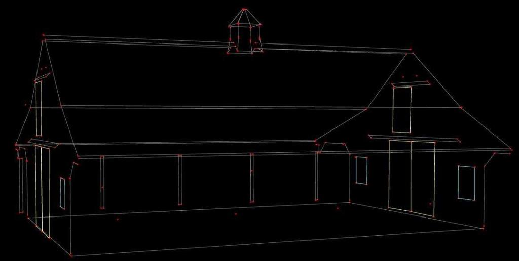
42

43 Current Applications Stockpiles: Landfills, Mines, Quarries for Volumetric Calculations Safer than sending surveyors into dangerous location Cheaper than manned flights Repeatable under most weather conditions Accurate enough for inventories

44 Current Applications Construction Job Sites: Planning stage: Typical contours, orthos, height models and mapping During: Monitoring of progress for job site updates and client updates For As Built documentation of utilities and underground services After completion: Complements 3D laser scanning for BIM (15min in air as opposed to days on the ground)

45 Current Applications Automated 3D Building Extraction Can be done from LiDAR or imagery point clouds Automated process used for building blocks for true 3D Can be joined with parcel data, building attributes, etc. in a 3D GIS


46 Current Applications 3D GIS Bentley Systems: Software to create 3D reality mesh Worked with helicopter flyer to capture and generate a 3D model of Philadelphia for the Papal Visit ESM Productions used the model in their planning of the events around the visit This application of UAS data is only limited by regulations and will explode due to the cost saving vs. helicopter for small areas Read more:

47 Current Applications Advantages of using 3D in GIS: Better predictive flood mapping Which floors will be flooded Viewshed analysis for aesthetics, line of sight and energy consumption shadows, airflow, reflectance Treat Dome for military and other threat analysis We live in a 3D world, our GIS should be in 3D as well!
 application from ESRI to turn vertical and oblique UAS imagery into orthos, point clouds and")
48 Current Applications 3D GIS ArcGIS\Drone2Map 3D Analyst for ArcGIS delivering some of the same tools as Skyline, but user must provide 3D data. Use of UAS could be cost effective to generate 3D for small areas Drone2Map (partnership with Pix4D) application from ESRI to turn vertical and oblique UAS imagery into orthos, point clouds and meshes for ingestion into ArcGIS D2M: Still producing 2.5D, but moving toward 3D and generating an appetite for planning in 3D


49 Current Applications Mapping: Currently limited by regulations and tools available For small applications, however, UAS data offers new levels of detail
50 Mapping Accuracy Testing

51 Keystone Accuracy Testing Keystone flew a privately owned barn in northeastern, PA in December of 2015 with two UAS. Each flight lasted approximately 15 minutes. Flight was in a circular pattern with alternating elevations. DJI X5 camera was approximately 35 ft. above terrain Sony A7R was approximately 68ft. above terrain Simultaneously, 38 control points were surveyed on the barn and ground

52 Equipment Used DJI Inspire 1 Pro with a DJI Zenmuse X5 camera 16 MP with a 15 mm lens Unobstructed views SteadiDrone Mavrik with a Sony A7R camera 36 MP with a 35mm lens PixHawk Autopilot customizable platform Pixel size for DJI averaged 0.10 inch NADIR and averaged 0.17 inch on barn Pixel size for the Sony averaged 0.10 inch as well but was 0.22 inch on barn as it averaged 137 ft. from barn

53 Datugram3D Workflow Image Loading The Datugram3D software has a simplified workflow of loading images, georeferencing images, measuring/data collection, approving the collected features and exporting the measurements. Before ingesting the images into the software, redundant images, those with blur and inconsistent lighting were removed from each set. After this process 31 images were ingested from the X5 set and 30 from the A7R set.

54 Datugram3D Workflow Georeferencing Control points are measured in several images, preferred to be on images at 90 degree angles Solution for entire dataset is generated using tie points and control points Image reference quality is indicated by an adjustable color system to show levels of matching quality. User defined levels set by preferences. The default value of 3 pixels for green was used in this case, with most points generating less than 2 pixels of latency.


55 Datugram3D Workflow Measurement Points, lines or polygons are drawn using a single image Feature is automatically detected on at least two other images. Feature is projected on all images If the automated feature detection fails, the user manually places the feature at the appropriate location in other images.

56 Datugram3D Workflow Approval In the approval stage, each feature can be confirmed in multiple images and more measurements can be made from suggested locations. Error estimation of object accuracy is available to view in coordinate system units and saved to a file before continuing to the data export stage.
57 Testing - Methodology Test 1 for both X5 and A7R: Test 2 for both X5 and A7R: Georeference Stage Georeference Stage For X5 and A7R 15 points on barn and 2 For X5 and A7R 7 points on barn and 2 ground ground points points Each point was measured in at least 2 images Each point was measured in at least 2 images Same points used for each camera type Same points used for each camera type Measurement Stage Measurement Stage For X5 and A7R 19 points on barn For X5 and A7R 19 points on barn measured as measured as features features Points were refined in Approval stage Points were refined in Approval stage Ability to refine points in this stage improved results
58 Results Control Points The control point estimations and measured points were exported and then compared to the surveyed locations. The points used as control had approximately 0.5 to 1 pixel Absolute Mean Error Control Point Residuals (Inches) Absolute Mean Min Max Camera Test Type X Y Z X Y Z X Y Z DJI X5 High Control DJI X5 Low Control Sony A7R High Control Sony A7R Low Control Mean, Min, Max of Absolute Residuals in Inches (Comparison of Surveyed Location and Measured) for Control Points
59 Results Check Points All of the tests resulted in absolute error values of 0.60 inch or less in X, Y and Z. The Sony A7R tests generating 1 or 2 pixel accuracy for both types of tests. With residuals evenly distributed among X, Y and Z, it is a stable and impressive solution. Note: DJI X5 pixel size of 0.17 inch and Sony A7R pixel size of 0.22 inch DJI MP of 16 is not recommended by Datumate, but still tested well With limited time of trial, blunders were not investigated. Check Point Residuals (Inches) Absolute Mean Min Max Camera Test X Y Z X Y Z X Y Z DJI X5 High Control DJI X5 Low Control Sony A7R High Control Sony A7R Low Control Mean, Min, Max of Absolute Residuals in Inches (Comparison of Surveyed Location and Measured) for Check Points

60 Results


61 Results
62 Conclusions Despite some portions of the project being less than ideal: ambient lighting changes, control placement, etc., the Datagram3D software was able to generate highly accurate data. For the Sony it is evident that an adequate number of control is necessary for best results, but an excessive amount results in rigidity of the solution and poorer results. This is likely due to the changing geometry of the small format cameras requiring flexibility in the bundled solution (especially in software that is not performing self calibration or using additional parameters) when high resolutions are possible. By contrast, the lower resolution (and possibly less stable geometry) from the DJI X5 needs larger amounts of control to limit mismatches and increase overall accuracy within the solution. Know Your Camera, Know Your Software and Test!
63 Future Developments
 Multiple sensor payloads Near real-time mapping Drone")
64 Near Future LiDAR higher accuracy/lighter weight Miniaturization of Inertial Measurement Units and GPS for removing the need for Ground control Longer battery life and heavier payloads Detection using other sensors (pipeline leak detection for example) Multiple sensor payloads Near real-time mapping Drone Deploy
 Persistence Solar power, tethered, mid-air refueling, auto battery exchange, etc.")
65 Not Too Distant Future Sub-millimeter pixel sizes and accuracy Beyond Line of Site operations will be commonplace: Amazon and Google will spearhead this but the mapping community will benefit Large aircraft for mapping Commercial version of Predator (I would call it Dove ) Persistence Solar power, tethered, mid-air refueling, auto battery exchange, etc. Ubiquitous News media will make a drone above you a chance for your 15 minutes of fame, not an invasion of privacy Swarming multiple coordinated UAS


66 Thank You! Contact Us David Day:
LAUNCHING YOUR UNMANNED AIRCRAFT PROGRAM
 LAUNCHING YOUR UNMANNED AIRCRAFT PROGRAM THE DARTDRONES TEAM UNMANNED AIRCRAFT APPLICATIONS AERIAL INSPECTIONS AERIAL INSPECTIONS Safer and faster alternative to visual inspection by an individual Damage
What is a UAS (Drone)
") UAS KCSI Aerial Patrol KCSI is Based in Bakersfield CA Established in 1993 Operates in 15 States KCSI has over 20 fulltime pilots Currently fly: Over 40,000 miles of pipeline a month 700 hours of production
UAS KCSI Aerial Patrol KCSI is Based in Bakersfield CA Established in 1993 Operates in 15 States KCSI has over 20 fulltime pilots Currently fly: Over 40,000 miles of pipeline a month 700 hours of production
How to Use Drones in Stormwater Management January 17, :30 a.m. 11:30 a.m. (Eastern)
") Webinar Training Series How to Use Drones in Stormwater Management January 17, 2019 10:30 a.m. 11:30 a.m. (Eastern) www.seswa.org Today s Presenters Robert Gecy Application Programmer Beaufort County,
Webinar Training Series How to Use Drones in Stormwater Management January 17, 2019 10:30 a.m. 11:30 a.m. (Eastern) www.seswa.org Today s Presenters Robert Gecy Application Programmer Beaufort County,
UAS to GIS Utilizing a low-cost Unmanned Aerial System (UAS) for Coastal Erosion Monitoring
 for Coastal Erosion Monitoring") UAS to GIS Utilizing a low-cost Unmanned Aerial System (UAS) for Coastal Erosion Monitoring Agenda Scope of today s presentation Demonstration Objectives Wrightsville Beach Test Area Masonboro Inlet Jetties
UAS to GIS Utilizing a low-cost Unmanned Aerial System (UAS) for Coastal Erosion Monitoring Agenda Scope of today s presentation Demonstration Objectives Wrightsville Beach Test Area Masonboro Inlet Jetties
OWEA Woolpert UAS Operations
 OWEA 2016 Woolpert UAS Operations UAS Rules and Regulations How Woolpert is Handling This The Exemption In December 2014 Woolpert received approval from the FAA regarding an exemption seeking relief from
Getting off the Ground: Implementing a Drone Program
 Getting off the Ground: Implementing a Drone Program November 2017 Steve Goldman, GISP GIS Manager / UAS Coordinator California Department of Fish and Wildlife http://www.wildlife.ca.gov Drones (UAS) What
UAV/Drone Uses and Laws
 UAV/Drone Uses and Laws Robert Moorhead Director of Geosystems Research and Northern Gulf Institutes Professor of Electrical & Computer Engineering Unmanned Aerial Systems (UASs) 3 components to the system:
Adventures in UAS: Experiences of a UAS Operator. Paul Beckwith, PE, CCM, LEED AP bd+c Navigator CS, LLC, President. Presented by:
 Adventures in UAS: Experiences of a UAS Operator Presented by: Paul Beckwith, PE, CCM, LEED AP bd+c Navigator CS, LLC, President Paul Beckwith, PE, CCM, LEED AP bd+c BA in Architectural Engineering from
DEFINITIONS DEFINITIONS 2/11/2017 REQUIREMENTS AND LIMITATIONS OF DRONE USE IN FORENSIC ACCIDENT RECONSTRUCTION
 REQUIREMENTS AND LIMITATIONS OF DRONE USE IN FORENSIC ACCIDENT RECONSTRUCTION ROGER BURGMEIER BURGMEIER CONSULTING INC. DEFINITIONS Aircraft: device that is used, or intended to be used, for flight. Drone:
LOW DOWN ON THE HIGH UP: USING DRONES FOR LAND CONSERVATION
 LOW DOWN ON THE HIGH UP: USING DRONES FOR LAND CONSERVATION TEXAS LAND CONSERVATION CONFERENCE MARCH 3, 2017 STEPHEN RAMIREZ STEWARDSHIP DIRECTOR TEXAS LAND CONSERVANCY RAY RENNER, RPLS, PMP MANAGER OF
2018 ENGINEERING EXPO Jon Thies NUAIR Director of Consulting
 2018 ENGINEERING EXPO Jon Thies NUAIR Director of Consulting Agenda Operating Under Current FAA Regulations suas Program Development Considerations suas Use Case Examples Quiz Regulations Small Unmanned
Unmanned Aerial Vehicles for Environmental Applications
 Unmanned Aerial Vehicles for Environmental Applications John Rankin, President, J.R. Canadian Mapping Ltd. 10 th Annual Professional Biology Conference April 23 rd, 2015 UAVs Our System Suitable Sites
DRONING FOR INFORMATION
 DRONING FOR INFORMATION Opportunity of Drones for Surveying and Mapping Practices By: Adam Smith, CP Matt Aguirre, PLS Overview Introduction Background Problem and Opportunity Issues and Mitigations Implementation
small Unmanned Aircraft Systems Arlington Police Department June 28, 2011
 suas small Unmanned Aircraft Systems Arlington Police Department June 28, 2011 1. Overview of APD suas program to date 2. Discuss the C.O.A. (FAA certificate of authorization to fly) and restrictions
Drone Technology: What Works for Industry & Landowners. Michael J. Buschermohle Interim Assistant Dean UT Extension
 Drone Technology: What Works for Industry & Landowners Michael J. Buschermohle Interim Assistant Dean UT Extension So You Want to Fly FAA Regulations UAS Platforms Cameras Applications in Forestry Current
GEOMATIC ASSESSMENT Membership Directory & Buyers Guide 97th Annual Conference Recap WINTER 2017/18
 WINTER 2017/18 GEOMATIC NC AWWA-WEA 3725 National Drive, Suite 217 Raleigh, NC 27612 ADDRESS SERVICE REQUESTED 2018 Membership Directory & Buyers Guide 97th Annual Conference Recap The official publication
Unmanned Aircraft Systems (UAS) 101
 101") Unmanned Aircraft Systems (UAS) 101 Presented to: AUVSI Cascade Chapter Future Robotics Forum Presented by: Michael Dement-Myers, (FAA), NextGen Branch Date: October 20, 2016 Overview Unmanned Aircraft
Unmanned Aircraft Systems (UAS) 101 Presented to: AUVSI Cascade Chapter Future Robotics Forum Presented by: Michael Dement-Myers, (FAA), NextGen Branch Date: October 20, 2016 Overview Unmanned Aircraft
Lone Star UAS Center. of Excellence and Innovation
 Lone Star UAS Center LSUASC Introduction of Excellence and Innovation Bringing UAS to America s Skies NASAO 85 th Annual Convention and Tradeshow UAS Emerging Technologies & Utilizations September 13,
Program. - Flight Operations (VRI) Motivation. The Aircraft / Sensors. Unmanned Aircraft Systems 8/1/17
 Motivation. The Aircraft / Sensors. Unmanned Aircraft Systems 8/1/17") Program Unmanned Aircraft in Agriculture: Flight Operations and FAA Certification Process * 1) Background. Wayne Woldt, Ph.D., P.E. Department of Biological Systems Engineering School of Natural Resources
Program Unmanned Aircraft in Agriculture: Flight Operations and FAA Certification Process * 1) Background. Wayne Woldt, Ph.D., P.E. Department of Biological Systems Engineering School of Natural Resources
Using UAS Technology for Invasive Plant Management
 Using UAS Technology for Invasive Plant Management Adam Benjamin, P.S.M. UF/IFAS Fort Lauderdale R.E.C. May 8, 2018 2018 Aquatic Weed Control Short Course Coral Springs, FL Using UAS Technology for Invasive
Unmanned Aircraft Systems (UAS) 101
 101") Unmanned Aircraft Systems (UAS) 101 Presented to: The American Association of State Highway and Transportation Officials Presented by: Dave May, FAA UAS Integration Office Date: What is a UAS? A UAS is
Unmanned Aircraft Systems (UAS) 101 Presented to: The American Association of State Highway and Transportation Officials Presented by: Dave May, FAA UAS Integration Office Date: What is a UAS? A UAS is
5 Day Operator Course. 1.0 AIRSPACE CLASSROOM ONLINE EXECUTIVE VO Terms X X Classification
 5 Day Operator Course 2 Day Executive Training 2 Day VO Training 0.1 INTRODUCTION CLASSROOM ONLINE EECUTIVE VO About Avion Solutions Purpose of the course Learning objectives Course outline and schedule
In-field and Remote Sensing for Precision Agriculture. John Nowatzki Extension Ag Machine Systems Specialist North Dakota State University
 In-field and Remote Sensing for Precision Agriculture John Nowatzki Extension Ag Machine Systems Specialist North Dakota State University UAS in Precision Agriculture In-field Sensors Selecting UAS Equipment
Drones in Construction: Beyond Pictures Capturing and Exploring Actionable Data
 Drones in Construction: Beyond Pictures Capturing and Exploring Actionable Data Hunter Cole & Jesse Creech Virtual Design + Construction Brasfield & Gorrie General Contractors Join the conversation #AU2016
UAV Program. What does it take to have a UAV Program Current Requirements Lemhi County UAV program
 UAV Program UAV Program What does it take to have a UAV Program Current Requirements Lemhi County UAV program What does it take to have a UAV program? Some Very Important Questions to Ask Before What type
UAV Flight Services Company. What We Do. What Sets us Apart
 UAV Flight Services Company A dedicated team of aviators, technologists, and engineers. What We Do UAV flight services for data collection, mapping, and inspection What Sets us Apart Extensive field experience,
NEW JERSEY COUNTIES EXCESS JOINT INSURANCE FUND 9 Campus Drive, Suite 216 Parsippany, NJ Telephone (201) BULLETIN NJCE 19-04
 BULLETIN NJCE 19-04") Date: January 1, 2019 NEW JERSEY COUNTIES EXCESS JOINT INSURANCE FUND 9 Campus Drive, Suite 216 Parsippany, NJ 07054 Telephone (201) 881-7632 BULLETIN NJCE 19-04 To: From: Re: Fund Commissioners of NJCE
Date: January 1, 2019 NEW JERSEY COUNTIES EXCESS JOINT INSURANCE FUND 9 Campus Drive, Suite 216 Parsippany, NJ 07054 Telephone (201) 881-7632 BULLETIN NJCE 19-04 To: From: Re: Fund Commissioners of NJCE
Mapping with Unmanned Airborne Systems (UAS)
") Mapping with Unmanned Airborne Systems (UAS) February 13, 2014 Engineering Architecture Design-Build Surveying GeoSpatial Solutions Today s Agenda Introductions / Objectives Current UAS Regulations (FAA)
Mapping with Unmanned Airborne Systems (UAS) February 13, 2014 Engineering Architecture Design-Build Surveying GeoSpatial Solutions Today s Agenda Introductions / Objectives Current UAS Regulations (FAA)
Unmanned Aircraft Systems (UAS) 101
 101") Unmanned Aircraft Systems (UAS) 101 Presented to: Presented by: Contract Management Conference Bryan Budds / Mike Soper, MDOT Date: March 5, 2019 Overview Unmanned Aircraft Systems What & Why FAA Authority
Unmanned Aircraft Systems (UAS) 101 Presented to: Presented by: Contract Management Conference Bryan Budds / Mike Soper, MDOT Date: March 5, 2019 Overview Unmanned Aircraft Systems What & Why FAA Authority
Unmanned Aerial Vehicles or How I learned to stop worrying and love drones!
 Unmanned Aerial Vehicles or How I learned to stop worrying and love drones! Dr. Charles O Neill Aerospace Engineer, UA Professor, Pilot charles-oneill.com or aero.ua.edu Brief History of Drones German
fll,' The University of Georgia O tfo:c o f rh.: Vu:.: Pre,id.:nt for Research
 November 30, 2015 fll,' - - - ----- I M.$------- The University of Georgia ------------------9 O tfo:c o f rh.: Vu:.: Pre,id.:nt for Research U.S. Department of Transportation Docket Management System
Coeur d Alene Tribe GIS Unmanned Aerial System (UAS) Program JAMES TWOTEETH BERNE JACKSON GIOVAN ALCALA SABINE KRIER
 Program JAMES TWOTEETH BERNE JACKSON GIOVAN ALCALA SABINE KRIER") Coeur d Alene Tribe GIS Unmanned Aerial System (UAS) Program JAMES TWOTEETH BERNE JACKSON GIOVAN ALCALA SABINE KRIER What is an Unmanned Aerial System (UAS)? Small, unmanned aircraft under 50 lbs. remotely
Coeur d Alene Tribe GIS Unmanned Aerial System (UAS) Program JAMES TWOTEETH BERNE JACKSON GIOVAN ALCALA SABINE KRIER What is an Unmanned Aerial System (UAS)? Small, unmanned aircraft under 50 lbs. remotely
Menlo Park Fire District Training Division. Unmanned Aerial System Pilot
 Menlo Park Fire District Training Division TASK BOOK FOR THE POSITION OF Unmanned Aerial System Pilot Date Issued TASK BOOK ASSIGNED TO: Individuals name, assignment DATE TASK BOOK INITIATED The material
Commit to Safety: Professional Pilots Always Use a Checklist INITIAL EQUIPMENT SETUP
 Commit to Safety: Professional Pilots Always Use a Checklist INITIAL EQUIPMENT SETUP READ THE MANUAL Familiarize yourself with all aspects of your suas before you even consider going out for your first
UNMANNED AIRCRAFT SYSTEMS (UAS) IN UTILITIES
 IN UTILITIES") UNMANNED AIRCRAFT SYSTEMS (UAS) IN UTILITIES Presented by: Dan Carbone Avion Unmanned Why Drones? Why Drones? Cost Effective Entire cost of a UAS program can be recouped in first-year man-hour savings
UNMANNED AIRCRAFT SYSTEMS (UAS) IN UTILITIES Presented by: Dan Carbone Avion Unmanned Why Drones? Why Drones? Cost Effective Entire cost of a UAS program can be recouped in first-year man-hour savings
WEBINAR: A BIRD S-EYE VIEW
 WEBINAR: A BIRD S-EYE VIEW DRONES IN AGRIBUSINESS JUNE 21, 2016 Hosted by Nexsen Pruet Presented by Ernie Pearson (Nexsen Pruet); Patrick Lohman (PrecisionHawk); and Kyle Snyder (NGAT/NCSU) FOUNDED IN
Using Geospatial Data in the Oil & Gas Industry. Dr. Stacey D. Lyle, RPLS
 Using Geospatial Data in the Oil & Gas Industry Dr. Stacey D. Lyle, RPLS Outcomes A Geospatial Data Science Center is an advanced database of information organized and accessible using multiple software
Western Service Area Unmanned Aircraft Systems (UAS) Update. Federal Aviation Administration. Defense Symposium
 Update. Federal Aviation Administration. Defense Symposium") Western Service Area Unmanned Aircraft Systems (UAS) Update Presented to: Presented by: Northwest Aerospace & Defense Symposium Matt Gammon, Tactical Operations Team, FAA Western Service Center Date: May
Western Service Area Unmanned Aircraft Systems (UAS) Update Presented to: Presented by: Northwest Aerospace & Defense Symposium Matt Gammon, Tactical Operations Team, FAA Western Service Center Date: May
Using UAVs for Aerial Mapping, Surveying and Photography
 Using UAVs for Aerial Mapping, Surveying and Photography Prepared for: Central Florida GIS Workshop 18 September 2013 Kevin Shortelle System Dynamics International, Inc kevinshortelle@bellsouth.net Presentation
EXAMPLE FLIGHT PLAN. Project Information UBC PRODUCTIONS APEX^ZERO. Prepared for: Paul Hodges Vice President, SFG Productions
 UBC PRODUCTIONS APEX^ZERO FLIGHT PLAN EXAMPLE Project Information Prepared for: Paul Hodges Vice President, SFG Productions Prepared by: Roger Apolinar & Eric Carpenter Remote Pilots in Command, APEX^ZERO
Unmanned Aircraft Systems (UAS): A Paradigm Shift in Aviation
: A Paradigm Shift in Aviation") Unmanned Aircraft Systems (UAS): A Paradigm Shift in Aviation Tom Haritos, Ed.S. Department of Aeronautical Science Embry-Riddle Aeronautical University Florida Airports Council (FAC) 2015 1 The trouble
Unmanned Aircraft Systems (UAS): A Paradigm Shift in Aviation Tom Haritos, Ed.S. Department of Aeronautical Science Embry-Riddle Aeronautical University Florida Airports Council (FAC) 2015 1 The trouble
The role of Unmanned Aircraft System (AUS) in search and rescue (SAR) operations
 in search and rescue (SAR) operations") The role of Unmanned Aircraft System (AUS) in search and rescue (SAR) operations Captain: Abdelkhalik Kamaleldin Soliman Selmy College of Maritime Transport & Technology Arab Academy for Science, Technology
The role of Unmanned Aircraft System (AUS) in search and rescue (SAR) operations Captain: Abdelkhalik Kamaleldin Soliman Selmy College of Maritime Transport & Technology Arab Academy for Science, Technology
Community College Risk Management Consortium July 21 22, 2016 Understanding the Evolving Landscape of Drone Regulations and Risk Management
 Community College Risk Management Consortium July 21 22, 2016 Understanding the Evolving Landscape of Drone Regulations and Risk Management The ABCs of UAVs July 2016 UAV Talking Points Drones are changing
Development and Testing of an Unmanned Aircraft Safety Beacon for Aerial Application Safety
 Development and Testing of an Unmanned Aircraft Safety Beacon for Aerial Application Safety Wayne Woldt, Ph.D., P.E., and Jacob Smith Biological Systems Engineering and School of Natural Resources University
Municipal Drone Operations Ben Roper City of College Station
 Municipal Drone Operations Ben Roper City of College Station Unmanned Aerial System (UAS) aka Drone You are establishing an aviation unit for your entity What could possible go wrong? https://youtu.be/aolm1aqkews
FAA Unmanned Aircraft Systems (UAS)
") FAA Unmanned Aircraft Systems (UAS) Overview: Proposed Small UAS Rule Presented To: Small Business Aviation Safety Roundtable Presented By: Mark Bury, Assistant Chief Counsel, Regulations Division of the
FAA Unmanned Aircraft Systems (UAS) Overview: Proposed Small UAS Rule Presented To: Small Business Aviation Safety Roundtable Presented By: Mark Bury, Assistant Chief Counsel, Regulations Division of the
A Drone s Eye View on Public Works Applications
 A Drone s Eye View on Public Works Applications APWA Construction Inspection Conference Parker, CO Jason Caldwell, VP of Business Development and Sales 2013, The Sanborn Map Company, Inc. Agenda Sanborn
Potential Uses and Considerations Regarding the Use of UAS Technology in Assessment. January 2015 Frank Giuffrida
 Potential Uses and Considerations Regarding the Use of UAS Technology in Assessment January 2015 Frank Giuffrida Table of Contents Current climate surrounding UAS use... 2 Assessing the value of properties
ONE PLATFORM, MULTIPLE APPLICATIONS: SURVEYING CONSTRUCTION FORESTRY AGRICULTURE ENVIRONMENT POWER ENGINEERING BIRDIE YOUR TAILOR-MADE UAV
 UAV BIRDIE BIRDIE YOUR TAILOR-MADE UAV ONE PLATFORM, MULTIPLE APPLICATIONS: SURVEYING CONSTRUCTION FORESTRY AGRICULTURE ENVIRONMENT POWER ENGINEERING BIRDIE UAV is the complete mapping solution, made for
Unmanned Aircraft Systems (UAS)
") Unmanned Aircraft Systems (UAS) Update Presented to: Airports Council International Presented by: Danielle J. Rinsler, AICP Date: Who is Operating UAS in the National Airspace System (NAS)?* Public (Governmental)
Unmanned Aircraft Systems (UAS) Update Presented to: Airports Council International Presented by: Danielle J. Rinsler, AICP Date: Who is Operating UAS in the National Airspace System (NAS)?* Public (Governmental)
UAS in Canada Stewart Baillie Chairman Unmanned Systems Canada Sept 2015
 UAS in Canada - 2015 Stewart Baillie Chairman Unmanned Systems Canada Sept 2015 My Focus Today.. Report on the growth of the UAS sector in Canada as a whole Provide background on UAS regulation in Canada
RISING PERFORMANCE. Civil aviation is an outlier. It s BY ERIK DAHLBERG
 RISING PERFORMANCE Compact mobile mapping systems can be installed on small passenger cars. Civil aviation is an outlier. It s among the few industries where tight government regulations are widely accepted
The Legal Environment for Commercial Unmanned Aircraft
 The Legal Environment for Commercial Unmanned Aircraft Overview The Legal Environment Who can fly them? A history of FAA policy to the present Asking for permission 2 Today s Legal Framework 3 Today s
Unmanned Aircraft Systems (UAS) 101
 101") Unmanned Aircraft Systems (UAS) 101 Presented to: ACC Airports Technical Workshop Presented by: David Russell, Program Analyst, UAS Integration Office, Date: August 10, 2016 Overview Unmanned Aircraft
Unmanned Aircraft Systems (UAS) 101 Presented to: ACC Airports Technical Workshop Presented by: David Russell, Program Analyst, UAS Integration Office, Date: August 10, 2016 Overview Unmanned Aircraft
COMMERCIAL OPERATIONS
 Cornell University UAV Guidelines Office of Risk Management and Insurance Purpose: The Office of Risk Management and Insurance has published guidelines as a resource for members of the University community
AUGUST 2017 GNSS REVIEW. Survey Economics Chances of success. Mobile Mapping Airport scanning. Stag s Leap Winery Pre-construction plan
 AUGUST 2017 GNSS REVIEW Survey Economics Chances of success Stag s Leap Winery Pre-construction plan Mobile Mapping Airport scanning RISING PERFORMANCE» ERIK DAHLBERG Civil aviation is an outlier. It s
Drone Pilot Course. Lesson 1 Study Guide- Regulations. Questions take from ASA Remote Pilot Test Prep Guide
 Lesson 1 Study Guide- Regulations 1. You are operating a 1280g (2.8lb) quadcopter for your own enjoyment. What FAA regulation is this suas operation subject to? a. 14 CFR 107 b. 14 CFR 101 2. You have
AGAZINE DECEMBER 2015/JANUARY 2016
 M IDWEST FLYER AGAZINE DECEMBER 2015/JANUARY 2016 Published For & By The Midwest Aviation Community Since 1978 midwestflyer.com Unmanned Aircraft Systems Technology Creating New Perspectives That Will
Unmanned Aircraft Systems (UAS) at the Jornada Experimental Range
 at the Jornada Experimental Range") Unmanned Aircraft Systems (UAS) at the Jornada Experimental Range Al Rango and the Jornada UAS Flight Team: Connie Maxwell, Amy Slaughter, Andrea Laliberte, Chris Pierce, Dave Thatcher, Jim Lenz, and Craig
Unmanned Aircraft Systems (UAS) at the Jornada Experimental Range Al Rango and the Jornada UAS Flight Team: Connie Maxwell, Amy Slaughter, Andrea Laliberte, Chris Pierce, Dave Thatcher, Jim Lenz, and Craig
National Regulatory Profile
 National Regulatory Profile Finland NOTE : In this form the following terms are used Drone = Remotely Piloted Aircraft (RPA) = Unmanned Aircraft (UA) = See definition below Drone Pilot = Remote Pilot (RP)
Presentation: UAS Helicopter Waran -1-
 Presentation: UAS Helicopter Waran -1- The unique design features of the Waran provide a superior payload capacity, prolonged endurance, stable flight patterns and a high degree of safety features. Technical
Unmanned Aircraft Systems in Disaster Management and National Preparedness
 Unmanned Aircraft Systems in Disaster Management and National Preparedness at the Hawaii Land Surveyors Association Matt Kobayashi Ted Ralston National Disaster Preparedness Training Center Honolulu Why
UNMANNED AIRCRAFT PROVISIONS IN FAA REAUTHORIZATION BILL
 UNMANNED AIRCRAFT PROVISIONS IN FAA REAUTHORIZATION BILL Section 341 Comprehensive Plan -Codifies in title 49 the requirement in the 2012 FAA reauthorization Act that a comprehensive plan to safely accelerate
UNMANNED AERIAL SYSTEM USE
 UNMANNED AERIAL SYSTEM USE Unmanned aircraft systems (UASs) come in a variety of shapes and sizes and serve diverse purposes. Also known as drones, unmanned vehicle systems (UVSs) and unmanned aerial vehicles
STOCKTON POLICE DEPARTMENT GENERAL ORDER UNMANNED AIRCRAFT SYSTEM SUBJECT. DATE: November 14, 2017 NO: V-6
 STOCKTON POLICE DEPARTMENT GENERAL ORDER UNMANNED AIRCRAFT SYSTEM SUBJECT DATE: November 14, 2017 NO: FROM: CHIEF ERIC JONES TO: ALL PERSONNEL INDEX: UNMANNED AIRCRAFT SYSTEM I. PURPOSE The purpose of
small Unmanned Aerial Systems (suas)
") 2018 WSC Annual Safety Conference small Unmanned Aerial Systems (suas) Presenter Introduction Chris Seider, CSP, PHR, CHST, ARM Senior Safety and Risk Management Specialist Foth & Van Dyke, LLC Chris.Seider@Foth.com
2018 WSC Annual Safety Conference small Unmanned Aerial Systems (suas) Presenter Introduction Chris Seider, CSP, PHR, CHST, ARM Senior Safety and Risk Management Specialist Foth & Van Dyke, LLC Chris.Seider@Foth.com
Unmanned Aircraft Systems (UAS) 101
 101") Unmanned Aircraft Systems (UAS) 101 Presented to: National Tribal Transportation Conference Presented by: Robert Winn, Aviation Safety Inspector, Unmanned Aircraft Systems Office Date: Overview Unmanned
Unmanned Aircraft Systems (UAS) 101 Presented to: National Tribal Transportation Conference Presented by: Robert Winn, Aviation Safety Inspector, Unmanned Aircraft Systems Office Date: Overview Unmanned
 Presented by: Lt. Michael J. Magda Team Leader, Firefighter, EMT -P, Hazardous Material Specialist, Private Pilot, Airframe & Power plant Mechanic Western Wayne County HMRT, Livonia Fire & Rescue And
UAS Unmanned Aircra: Systems in Forest Management
 UAS Unmanned Aircra: Systems in Forest Management UAS What are they? Unmanned Aircra: Systems (UAS) fill niche built upon military UAV technologies Most common plahorms Fixed Wing Rotorcra: Primary uses
UAS Program. Todd Graetz Director, Technology Services UAS Program / Advanced Train Operations 1
 UAS Program Todd Graetz Director, Technology Services UAS Program / Advanced Train Operations 1 The elements of the program Business requirements Line of Sight (LOS) Implementation Applications Data/product
Use of UAS in Research and Education
 Use of UAS in Research and Education Kelly A. Rusch, Ph.D., P.E. Vice President for Research and Creative Activity-NDSU James L. Grimsley Associate Vice President for Research OU Norman Campus 11/14/16
Air Law. Iain Darby NAPC/PH-NSIL IAEA. International Atomic Energy Agency
 Air Law Iain Darby NAPC/PH-NSIL International Atomic Energy Agency Aviation Regulations International Civil Aviation Organisation (ICAO) Convention on International Civil Aviation also known as the Chicago
Unmanned Aircraft Systems (UAS)
") Unmanned Aircraft Systems (UAS) Use & Regulation Presented to: GUIRR Nat l Academy of Sciences Presented by: Robert A. Pappas Special Rules Coordinator UAS Integration Office Date: Who & How UAS are Operating
Unmanned Aircraft Systems (UAS) Use & Regulation Presented to: GUIRR Nat l Academy of Sciences Presented by: Robert A. Pappas Special Rules Coordinator UAS Integration Office Date: Who & How UAS are Operating
Outline Why CCSU PinnaclX and Eversource
 CBIA 2018 Safety & Health Conference Wednesday, May 23, 2018 The Red Lion Hotel Cromwell 100 Berlin Road, Cromwell, CT Drones & Safety: A Brave New World Alfred A. Gates, Ph.D. CFI Helicopter, UAS Remote
Civil Remotely Piloted Aircraft System (RPAS) Regulations in Australia
 Regulations in Australia") Civil Remotely Piloted Aircraft System (RPAS) Regulations in Australia Cees Bil School of Engineering RMIT University Melbourne AUSTRALIA bil@rmit.edu.au ICAS Workshop: Intelligent and Autonomous Technologies
Civil Remotely Piloted Aircraft System (RPAS) Regulations in Australia Cees Bil School of Engineering RMIT University Melbourne AUSTRALIA bil@rmit.edu.au ICAS Workshop: Intelligent and Autonomous Technologies
The FAA rolls out its final small UAS rule for commercial operations: The expected; The pleasant surprises; The known unknowns;...
 The FAA rolls out its final small UAS rule for commercial operations: The expected; The pleasant surprises; The known unknowns;... and what s next Gregory S. Walden Senior Counsel, Akin Gump Strauss Hauer
2017 PLSO Fall Seminar. UAV s Flying to Finished Product
 2017 PLSO Fall Seminar UAV s Flying to Finished Product Scott D. Kraner, P.E. Subject Matter Expert Civil Infrastructure Session Outline UAV Overview and Applications How to obtain a remote pilot certificate?
SOUTH DAKOTA STATE UNIVERSITY Policy and Procedure Manual
 Office/Contact: Division of Research and Economic Development Source: Federal Aviation Administration (FAA) UAS Regulations and Policies; SDBOR Policy 1:30; FAA Modernization and Reform Act of 2012 (P.L.
Drones and the Fire Service 10/01/2016
 Drones and the Fire Service 10/01/2016 By JOSHUA LARSON Small unmanned aircraft systems (UAS), also known as drones or unmanned aerial vehicles, have become one of the fastest growing industries in the
The Skyward Platform Helps You Manage UAV Operations
 The Skyward Platform Helps You Manage UAV Operations About Skyward Skyward s cloud-based UAV management platform powers scalable, efficient, safe, and insurable UAV operations for small businesses and
OFWIM and DRONES How to stay out of trouble
 OFWIM and DRONES How to stay out of trouble AMA, FAA, and FARs FAA 2012 Reform and Modernization Act 2014 Interpretive Rule AMA 550 AMA 560 AC91-57 FAR 91.119 d1 NPRM Section 333 United States v. Causby328
Questions to Answer: The Rules. Unmanned Aerial Systems (UAS): What You Need to Know. 1. Should we be leveraging UAS?
: What You Need to Know. 1. Should we be leveraging UAS?") Unmanned Aerial Systems (UAS): What You Need to Know Colorado SWANA Annual Conference September 13, 2017 Questions to Answer: 1. Should we be leveraging UAS? 2. Should we self-perform UAS work? 3. If we
Unmanned Aerial Systems (UAS): What You Need to Know Colorado SWANA Annual Conference September 13, 2017 Questions to Answer: 1. Should we be leveraging UAS? 2. Should we self-perform UAS work? 3. If we
Sam Houston State University UAS Use Checklist
 Sam Houston State University UAS Use Checklist The FAA Part 107 of the Code of Federal Regulations and the Sam Houston State University President s Office Policy PRE-27 determine the minimum requirements
Regional implementation of Electronic Terrain and Obstacle data (e-tod) (Presented by Jeppesen)
 (Presented by Jeppesen)") International Civil Aviation Organization SAM/IG/13-WP/39 South American Regional Office 5/04/14 Thirteenth Workshop/Meeting of the SAM Implementation Group English only (SAM/IG/13) - Regional Project
International Civil Aviation Organization SAM/IG/13-WP/39 South American Regional Office 5/04/14 Thirteenth Workshop/Meeting of the SAM Implementation Group English only (SAM/IG/13) - Regional Project
UAS Overview IDOT s UAS Program
 Unmanned Aircraft Systems (UAS) UAS Overview IDOT s UAS Program Linda Schumm Bureau Chief Aviation Safety Linda.Schumm@Illinois.gov October 18, 2017 Bill Viste Project Coordinator William.Viste@Illinois.gov
State of the UAS Industry for Insurance and Construction
 State of the UAS Industry for Insurance and Construction A Drone by any Other Name There are many terms for drones in use today The industry is trying to shy away from drone verbiage since it has military
Ohio UAS Center - Enabling Flight 2016 Ohio Planning Conference Fred Judson, GISP UAS Program Director
 Ohio UAS Center - Enabling Flight 2016 Ohio Planning Conference Fred Judson, GISP UAS Program Director Fred.Judson@dot.state.oh.us How It Began (For Me) Formalization of GIS in the district. Implementation
Re: Exemption Request Section 333 of the FAA Reform Act and Part 11 of the Federal Aviation Regulations
 September 04, 2014 U. S. Department of Transportation Docket Management System 1200 New Jersey Ave., SE Washington, DC 20590 Re: Exemption Request Section 333 of the FAA Reform Act and Part 11 of the Federal
Hidalgo County Drone Program. Standard Operating Procedure (SOP) Template. February 23, 2017
 Template. February 23, 2017") Hidalgo County Drone Program Standard Operating Procedure (SOP) Template The following is a detailed (but intended as a comprehensive) framework of topics to be covered in a Standard Operating Procedure
Hidalgo County Drone Program Standard Operating Procedure (SOP) Template The following is a detailed (but intended as a comprehensive) framework of topics to be covered in a Standard Operating Procedure
NASA s Automatic Dependent Surveillance Broadcast: ADS-B Sense-and-Avoid System
 NASA s Automatic Dependent Surveillance Broadcast: ADS-B Sense-and-Avoid System October 30, 2014 Ricardo Arteaga NASA Armstrong Flight Research Center is a world class leader in cutting-edge Systems Engineer
Hazard Identification Questionnaire
 Hazard Identification Questionnaire OVERVIEW This questionnaire is designed to help identify potential risks and help identify areas of risk exposure. It is not an exhaustive list. This questionnaire is
Drones, Robots and Public Safety
 Drones, Robots and Public Safety IWCE Thursday, March 30, 2017 11:30 am - 12:45 pm Room: S230 Session Number: TH12 The member organizations of the National Public Safety Telecommunications Council are
Part 107 Regulations in Plain English
 Part 107 Regulations in Plain English www.onlinegroundschool.com This applies to anyone flying an Unmanned Aircraft System (UAS) for any kind of compensation. This does not have to be monetary, it could
FAA FORM UAS COA Attachment FAA
 Page 1 of 6 DEPARTMENT OF TRANSPORTATION FEDERAL AVIATION ADMINISTRATION CERTIFICATE OF WAIVER OR AUTHORIZATION ISSUED TO Xcam Aerials, Inc. 10197 SE 144th Place Summerfield, FL 34491 This certificate
Launching a New Surveying Perspective
 Launching a New Surveying Perspective >> By Mary Jo Wagner A 3 km2 orthomosaic shows the entire construction site and surroundings. On the upper part of the mosaic are the Bristol Channel; the existing
USE OF REMOTELY PILOTED AIRCRAFT AND MODEL AIRCRAFT IN AVIATION
 luo Regulation 1 (10) OPS M1-32 Issued: 4 December 2018 Enters into force: 7 December 2018 Validity: indefinitely Legal basis: Aviation Act (864/2014), Sections 5, 9 and 57 Act on Transport Services (320/2017),
CAR PART VIII SUBPART 10 OPERATION OF UNMANNED AERIAL SYSTEMS WITHIN THE UNITED ARAB EMIRATES
 CAR PART VIII SUBPART 10 OPERATION OF UNMANNED AERIAL SYSTEMS WITHIN THE UNITED ARAB EMIRATES Issue no: Initial Page 1 of 21 Issue date: April 2015 FOREWORD 1- This is the initial issue of this regulation.
DRONES + AIRPORTS: BUZZ AROUND HARTSFIELD-JACKSON
 DRONES + AIRPORTS: BUZZ AROUND HARTSFIELD-JACKSON ACI-NA Legal Affairs Spring Conference Elizabeth Wharton, Senior Asst. City Attorney elizabeth.wharton@atl.com ATL Activities UAS Part 107 Operations contractors,
UNMANNED AIRCRAFT SYSTEMS (UAS) FOR PUBLIC POWER OPERATIONS AN OVERVIEW ON HOW DRONES ARE IMPACTING THE ENERGY INDUSTRY
 FOR PUBLIC POWER OPERATIONS AN OVERVIEW ON HOW DRONES ARE IMPACTING THE ENERGY INDUSTRY") UNMANNED AIRCRAFT SYSTEMS (UAS) FOR PUBLIC POWER OPERATIONS AN OVERVIEW ON HOW DRONES ARE IMPACTING THE ENERGY INDUSTRY ABOUT CHRISTOPHER TODD Founder and president of Airborne Response, Miamibased UAS
UNMANNED AIRCRAFT SYSTEMS (UAS) FOR PUBLIC POWER OPERATIONS AN OVERVIEW ON HOW DRONES ARE IMPACTING THE ENERGY INDUSTRY ABOUT CHRISTOPHER TODD Founder and president of Airborne Response, Miamibased UAS
Airworthiness Certification. The UAS proposed by the petitioner are the.
 2 Airworthiness Certification The UAS proposed by the petitioner are the. The petitioner requested relief from 14 CFR part 21, Certification procedures for products and parts, Subpart H Airworthiness Certificates.