Using Geospatial Data in the Oil & Gas Industry. Dr. Stacey D. Lyle, RPLS
|
|
|
- Melina Webster
- 6 years ago
- Views:
Transcription


1 Using Geospatial Data in the Oil & Gas Industry Dr. Stacey D. Lyle, RPLS
2 Outcomes A Geospatial Data Science Center is an advanced database of information organized and accessible using multiple software tools on the desktop, web or cell phone. Dr. Lyle will walk through a complete life cycle workflow for exploration of Oil & Gas production. Dr. Lyle will demonstrate how his new UAV Rapid Design Tool, "Status Check" and "Level-up" technology using his Geospatial Data Science Center places Surveyors as leaders in managing Oil & Gas data in the future.
3 Terms UAS-Unmanned Aircraft System suas- small Unmanned Aircraft System UAV- Unmanned Aerial Vehicle Commonly known as a drone. KBYF- Know before you Fly.
4 Fly for Fun Fly for Work Pilot Requirements No pilot requirements Must have Remote Pilot Airman Certificate Must be 16 years old Must pass TSA vetting Aircraft Requirements Must be registered if over 0.55 lbs. Must be less than 55 lbs. Must be registered if over 0.55 lbs. (online) Must undergo pre-flight check to ensure UAS is in condition for safe operation Location Requirements 5 miles from airports without prior notification to Class G airspace* airport and air traffic control Operating Rules Must ALWAYS yield right of way to manned aircraft Must keep the aircraft in sight (visual line-ofsight) UAS must be under 55 lbs. Must follow community-based safety guidelines Must notify airport and air traffic control tower Must keep the aircraft in sight (visual line-of-sight)* Must fly under 400 feet* Must fly during the day* Must fly at or below 100 mph* Must yield right of way to manned aircraft* Must NOT fly over people* Must NOT fly from a moving vehicle* before flying within 5 miles of an airport Example Applications Educational or recreational flying only Flying for commercial use (e.g. providing aerial surveying or photography services) Flying incidental to a business (e.g. doing roof inspections or real estate photography) Legal or Regulatory Basis Public Law , Section 336 Special Rule Title 14 of the Code of Federal Regulation (14 CFR) Part 107 for Model Aircraft FAA Interpretation of the Special Rule for Model Aircraft
5 FAA License RP 107 Remote Pilot Small Unmanned Aircraft Systems Airman Certification Standards FAA-S-ACS CFR part 71; AC 107-2; FAA-H ; AIM

6 Knowledge Test - Score 70% Pass
7 107 Requirements An applicant to take the knowledge test must be at least 14 years of age. Proper identification must be provided which contains the applicant's 1. Photograph; 2. Signature; 3. Date of birth; 4. If the permanent mailing address is a post office box number, then the applicant must provide a current residential address.
8 Regulations of UAV s
9 14 CFR part lbs or less Waivable sections of part 107 Operation from a moving vehicle or aircraft ( )* Daylight operation ( ) Visual line of sight aircraft operation ( )* Visual observer ( ) Operation of multiple small unmanned aircraft systems ( ) Yielding the right of way ( (a)) Operation over people ( ) Operation in certain airspace ( ) Operating limitations for small unmanned aircraft ( )
10 14 CFR part lbs or less Unmanned aircraft must weigh less than 55 lbs. (25 kg). Visual line-of-sight (VLOS) only; the unmanned aircraft must remain within VLOS of the remote pilot in command and the person manipulating the flight controls of the small UAS. Alternatively, the unmanned aircraft must remain within VLOS of the visual observer; unaided by any device other than corrective lenses. Small unmanned aircraft may not operate over any persons not directly participating in the operation, not under a covered structure, and not inside a covered stationary vehicle. Daylight-only operations, or civil twilight (30 minutes before official sunrise to 30 minutes after official sunset, local time) with appropriate anti-collision lighting. Must yield right of way to other aircraft. May use visual observer (VO) but not required. First-person view camera cannot satisfy see-and-avoid requirement but can be used as long as requirement is satisfied in other ways. Maximum groundspeed of 100 mph (87 knots). Maximum altitude of 400 feet above ground level (AGL) or, if higher than 400 feet AGL, remain within 400 feet of a structure. Minimum weather visibility of 3 miles from control station. Operations in Class B, C, D and E airspace are allowed with the required ATC permission. Operations in Class G airspace are allowed without ATC permission. No person may act as a remote pilot in command or VO for more than one unmanned aircraft operation at one time. No operations from a moving aircraft. No operations from a moving vehicle unless the operation is over a sparsely populated area. No careless or reckless operations. No carriage of hazardous materials. FAA airworthiness certification is not required. However, the remote pilot in command must conduct a preflight check of the small UAS to ensure that it is in a condition for safe operation.
11 Model Aircraft Part 107 does not apply to model aircraft that satisfy all of the criteria specified in section 336 of Public Law The rule codifies the FAA s enforcement authority in part 101 by prohibiting model aircraft operators from endangering the safety of the NAS.
12 Section 333 By law, any aircraft operation in the national airspace requires a certificated and registered aircraft, a licensed pilot, and operational approval. Petitions granted 5,551
13 B4U Fly Smartphone App A clear "status" indicator that immediately informs the operator about the current or planned location. For example, it shows flying in the Special Flight Rules Area around Washington, D.C. is prohibited. Information on the parameters that drive the status indicator A "Planner Mode" for future flights in different locations Informative, interactive maps with filtering options Links to other FAA UAS resources and regulatory information
14 Texas State Law 423, revised Pending Sec NONAPPLICABILITY. (a) It is lawful to capture an image using an unmanned aircraft in this state: (5) if the image is captured by or for an electric or natural gas utility or a telecommunications provider: (A) for operations and maintenance of utility or telecommunications facilities for the purpose of maintaining utility or telecommunications system reliability and integrity; (B) for inspecting utility or telecommunications facilities to determine repair, maintenance, or replacement needs during and after construction of such facilities; (C) for assessing vegetation growth for the purpose of maintaining clearances on utility or telecommunications easements; and (D) for utility or telecommunications facility routing and siting for the purpose of providing utility or telecommunications service (6) with the consent of the individual who owns or lawfully occupies the real property captured in the image;
15 Texas State Law 423, revised Pending (17) if the image is captured by the owner or operator of an oil, gas, water, or other pipeline for the purpose of inspecting, maintaining, or repairing pipelines or other related facilities, and is captured without the intent to conduct surveillance on an individual or real property located in this state; (18) in connection with oil pipeline safety and rig protection; (20) if the image is captured by a registered professional land surveyor in connection with the practice of professional surveying, as those terms are defined by Section , Occupations Code, provided that no individual is identifiable in the image; [or] (21) if the image is captured by a professional engineer licensed under Subchapter G, Chapter 1001, Occupations Code, in connection with the practice of engineering, as defined by Section , Occupations Code, provided that no individual is identifiable in the image;


16 Evaluation of UAS Equipment and Software It s about the DATA!!


17 Basics of Photogrammetry and Remote Sensing Spatial resolution is a term that refers to the number of pixels utilized in construction of a digital image. Images having higher spatial resolution are composed with a greater number of pixels than those of lower spatial resolution. Examples; 1 m pixels, 1 fts pixels, 0.25 ft pixels, ¼ pixels, etc Pixel Spatial Resolution Height Above Ground
18 DSLR or point-and-shoot, digital cameras use one of two sensor types: charged-coupled device (CCD) or complementary metal-oxide semiconductor (CMOS). Example: Cannon IXUS MP Sensor Dimensions: H x 4.62 mm or 650 pixel / mm - Pixel 1/650 mm or m - Focal Length 6.5 mm Flying Height 150 m m/ 150 m = m / D GND D GND = m a d a D a 1 SF da Da Ha
19 Camera Configuration Set shutter speed= Automatic. Set ISO = as low as possible (minimum 100). Set aperture = Automatic (Use sun shield if available) Focus mode = Manual Focus on Infinity No Digital Zoom, Resizing/cropping/rotation, Optical Stabilization, Auto Zoom, Flash Ref. Pix4D Getting Started and Manual; MicroStation ContextCapture Acquisition Guide
20 3D Stereo or Ortho Photo Ortho or Nadir- Camera pointing 90⁰ to the ground Overlap- (Base to Height Ratio) is the amount of common coverage between two images to make a 3D model along flight line Minimal 60% Ideal 80% Sidelap- is the amount of common coverage between two images on either side of flight lines 3D Overlap

21 Mission Planning Ground Mapping Fly mission that covers subject area with complete Neat Model. Fly multiple times at different elevations. Fly with Camera tilt 15⁰ off Nadir. Overlap small missions on large areas. Ref. Pix4D 3D Flight Mission


22 Mission Planning Inspection Fly mission circling around structure. Fly at different elevations. Fly with Camera tilt 15⁰ off Nadir. Overlap small missions on large areas. Ref. Pix4D Ref. MicroStation
23 Digital Orthography Photo and Structure from Motion Structure from motion. Structure from motion (SfM) is a photogrammetric range imaging technique for estimating threedimensional structures from two-dimensional image sequences that may be coupled with local motion signals. It is studied in the fields of computer vision and visual perception. Digital photogrammetry, softcopy uses manual and automatic techniques for capturing, processing, and analyzing digital imagery beginning either by scanning analog film or by direct digital image capture.


 to the Earth.")


24 LiDAR LIDAR, which stands for Light Detection and Ranging, is a remote sensing method that uses light in the form of a pulsed laser to measure ranges (variable distances) to the Earth. Types- Linear or Array Swath = Flying Height to Field of Range 0-360⁰ Scan rate= k shots/sec Accuracy = m
25 Unmanned Aircraft System Airframe- Body, Wings, Blades Power- Combustion Engine, Electric Motor, Fuel, Battery, Gas, Wind Computing- Flight Controller, Auto Pilot, Sensor Controller, Flight Controller Board(s) Positioning- GPS, INS, Altimeter, Compass, SLAM, SoO, Radio-Ranging Communication- Control, Tracking, Positioning Sensors- Imaging, Scanning, Environmental, Communication


26 Rotary vs. Fixed Wing Considerations Project Outcomes/Application Weight Flight Duration Wind Mapping or Inspecting Area of Coverage Cost GCP or No-GCP

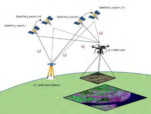
27 GNSS INS GPS for Navigation and Control GPS for Images Direct Georeferencing GCP RTK Post Processing Video Image EXIF Header INS for Rotation
28
29 TG TG- EC Pix4D Drone Deploy Kespry Data Mapper Agisoft 2d3- Tacitview Cost Free Free 1 $12,500 $299 /mo? $299 /mo $3,500 $7,500 Online YES YES NO YES YES YES NO NO Desktop YES YES YES NO NO YES YES YES ALL Drones YES YES YES YES No YES YES YES Data YES YES YES YES YES YES YES YES Management GPS YES YES NO NO NO NO NO NO Processing Ground Control NO NO YES? YES YES YES YES Orthomosaic YES YES YES YES YES YES YES YES Point Cloud YES YES YES YES YES YES YES YES NASAData Fuse YES YES NO NO NO NO NO NO Height Verify YES YES YES YES? YES YES YES Unlimited NO YES YES YES NO YES YES YES Storage Shared Results YES YES NO NO NO NO NO NO Open-Source YES YES NO NO NO NO NO NO

30 Workflow Data Collection 1. Restricted Areas 2. Mission and Site Selection 1. Launch/Land 2. VLOS 3. Sun Angle Culmination 4. UAV 1. Type 2. Sensor 3. Batteries 5. Targets GCP 6. GPS- GCP, RTK or PP 1. Base to Rover Radio Mission 7. Learn the Controller 1. Power 2. Radio 3. Controls 8. Upload the Mission to the Drone 1. Wifi 2. Bluetooth 3. Wired 9. Watch 10. Re-fly New height repeat
31 Workflow StoryMap GeoCube Site Development Method 1 Method 2

32 Geoscience Geographic Information Science and Technology Dr. Stacey D. Lyle, RPLS
NEW JERSEY COUNTIES EXCESS JOINT INSURANCE FUND 9 Campus Drive, Suite 216 Parsippany, NJ Telephone (201) BULLETIN NJCE 19-04
 BULLETIN NJCE 19-04") Date: January 1, 2019 NEW JERSEY COUNTIES EXCESS JOINT INSURANCE FUND 9 Campus Drive, Suite 216 Parsippany, NJ 07054 Telephone (201) 881-7632 BULLETIN NJCE 19-04 To: From: Re: Fund Commissioners of NJCE
Date: January 1, 2019 NEW JERSEY COUNTIES EXCESS JOINT INSURANCE FUND 9 Campus Drive, Suite 216 Parsippany, NJ 07054 Telephone (201) 881-7632 BULLETIN NJCE 19-04 To: From: Re: Fund Commissioners of NJCE
Unmanned Aircraft Systems (UAS) 101
 101") Unmanned Aircraft Systems (UAS) 101 Presented to: AUVSI Cascade Chapter Future Robotics Forum Presented by: Michael Dement-Myers, (FAA), NextGen Branch Date: October 20, 2016 Overview Unmanned Aircraft
Unmanned Aircraft Systems (UAS) 101 Presented to: AUVSI Cascade Chapter Future Robotics Forum Presented by: Michael Dement-Myers, (FAA), NextGen Branch Date: October 20, 2016 Overview Unmanned Aircraft
FAA Unmanned Aircraft Systems (UAS)
") FAA Unmanned Aircraft Systems (UAS) Overview: Proposed Small UAS Rule Presented To: Small Business Aviation Safety Roundtable Presented By: Mark Bury, Assistant Chief Counsel, Regulations Division of the
FAA Unmanned Aircraft Systems (UAS) Overview: Proposed Small UAS Rule Presented To: Small Business Aviation Safety Roundtable Presented By: Mark Bury, Assistant Chief Counsel, Regulations Division of the
2017 PLSO Fall Seminar. UAV s Flying to Finished Product
 2017 PLSO Fall Seminar UAV s Flying to Finished Product Scott D. Kraner, P.E. Subject Matter Expert Civil Infrastructure Session Outline UAV Overview and Applications How to obtain a remote pilot certificate?
2018 ENGINEERING EXPO Jon Thies NUAIR Director of Consulting
 2018 ENGINEERING EXPO Jon Thies NUAIR Director of Consulting Agenda Operating Under Current FAA Regulations suas Program Development Considerations suas Use Case Examples Quiz Regulations Small Unmanned
Remote Controlled Aircraft Permit Instructions
 The use of remote controlled aircraft is regulated within State Parks by WAC 352-32-130 (5) which allows for the flying of remote controlled aircraft with written permission of the Director, or designee.
Unmanned Aircraft Systems (UAS) 101
 101") Unmanned Aircraft Systems (UAS) 101 Presented to: ACC Airports Technical Workshop Presented by: David Russell, Program Analyst, UAS Integration Office, Date: August 10, 2016 Overview Unmanned Aircraft
Unmanned Aircraft Systems (UAS) 101 Presented to: ACC Airports Technical Workshop Presented by: David Russell, Program Analyst, UAS Integration Office, Date: August 10, 2016 Overview Unmanned Aircraft
Drone Technology: What Works for Industry & Landowners. Michael J. Buschermohle Interim Assistant Dean UT Extension
 Drone Technology: What Works for Industry & Landowners Michael J. Buschermohle Interim Assistant Dean UT Extension So You Want to Fly FAA Regulations UAS Platforms Cameras Applications in Forestry Current
Community College Risk Management Consortium July 21 22, 2016 Understanding the Evolving Landscape of Drone Regulations and Risk Management
 Community College Risk Management Consortium July 21 22, 2016 Understanding the Evolving Landscape of Drone Regulations and Risk Management The ABCs of UAVs July 2016 UAV Talking Points Drones are changing
Part 107 Regulations in Plain English
 Part 107 Regulations in Plain English www.onlinegroundschool.com This applies to anyone flying an Unmanned Aircraft System (UAS) for any kind of compensation. This does not have to be monetary, it could
Unmanned Aircraft Systems (UAS) 101
 101") Unmanned Aircraft Systems (UAS) 101 Presented to: National Tribal Transportation Conference Presented by: Robert Winn, Aviation Safety Inspector, Unmanned Aircraft Systems Office Date: Overview Unmanned
Unmanned Aircraft Systems (UAS) 101 Presented to: National Tribal Transportation Conference Presented by: Robert Winn, Aviation Safety Inspector, Unmanned Aircraft Systems Office Date: Overview Unmanned
UAV Program. What does it take to have a UAV Program Current Requirements Lemhi County UAV program
 UAV Program UAV Program What does it take to have a UAV Program Current Requirements Lemhi County UAV program What does it take to have a UAV program? Some Very Important Questions to Ask Before What type
DEFINITIONS DEFINITIONS 2/11/2017 REQUIREMENTS AND LIMITATIONS OF DRONE USE IN FORENSIC ACCIDENT RECONSTRUCTION
 REQUIREMENTS AND LIMITATIONS OF DRONE USE IN FORENSIC ACCIDENT RECONSTRUCTION ROGER BURGMEIER BURGMEIER CONSULTING INC. DEFINITIONS Aircraft: device that is used, or intended to be used, for flight. Drone:
Unmanned Aircraft Systems (UAS) 101
 101") Unmanned Aircraft Systems (UAS) 101 Presented to: The American Association of State Highway and Transportation Officials Presented by: Dave May, FAA UAS Integration Office Date: What is a UAS? A UAS is
Unmanned Aircraft Systems (UAS) 101 Presented to: The American Association of State Highway and Transportation Officials Presented by: Dave May, FAA UAS Integration Office Date: What is a UAS? A UAS is
UNMANNED AERIAL SYSTEM USE
 UNMANNED AERIAL SYSTEM USE Unmanned aircraft systems (UASs) come in a variety of shapes and sizes and serve diverse purposes. Also known as drones, unmanned vehicle systems (UVSs) and unmanned aerial vehicles
LAUNCHING YOUR UNMANNED AIRCRAFT PROGRAM
 LAUNCHING YOUR UNMANNED AIRCRAFT PROGRAM THE DARTDRONES TEAM UNMANNED AIRCRAFT APPLICATIONS AERIAL INSPECTIONS AERIAL INSPECTIONS Safer and faster alternative to visual inspection by an individual Damage
Program. - Flight Operations (VRI) Motivation. The Aircraft / Sensors. Unmanned Aircraft Systems 8/1/17
 Motivation. The Aircraft / Sensors. Unmanned Aircraft Systems 8/1/17") Program Unmanned Aircraft in Agriculture: Flight Operations and FAA Certification Process * 1) Background. Wayne Woldt, Ph.D., P.E. Department of Biological Systems Engineering School of Natural Resources
Program Unmanned Aircraft in Agriculture: Flight Operations and FAA Certification Process * 1) Background. Wayne Woldt, Ph.D., P.E. Department of Biological Systems Engineering School of Natural Resources
small Unmanned Aircraft Systems Arlington Police Department June 28, 2011
 suas small Unmanned Aircraft Systems Arlington Police Department June 28, 2011 1. Overview of APD suas program to date 2. Discuss the C.O.A. (FAA certificate of authorization to fly) and restrictions
DRONES + AIRPORTS: BUZZ AROUND HARTSFIELD-JACKSON
 DRONES + AIRPORTS: BUZZ AROUND HARTSFIELD-JACKSON ACI-NA Legal Affairs Spring Conference Elizabeth Wharton, Senior Asst. City Attorney elizabeth.wharton@atl.com ATL Activities UAS Part 107 Operations contractors,
fll,' The University of Georgia O tfo:c o f rh.: Vu:.: Pre,id.:nt for Research
 November 30, 2015 fll,' - - - ----- I M.$------- The University of Georgia ------------------9 O tfo:c o f rh.: Vu:.: Pre,id.:nt for Research U.S. Department of Transportation Docket Management System
Drone Pilot Course. Lesson 1 Study Guide- Regulations. Questions take from ASA Remote Pilot Test Prep Guide
 Lesson 1 Study Guide- Regulations 1. You are operating a 1280g (2.8lb) quadcopter for your own enjoyment. What FAA regulation is this suas operation subject to? a. 14 CFR 107 b. 14 CFR 101 2. You have
How to Use Drones in Stormwater Management January 17, :30 a.m. 11:30 a.m. (Eastern)
") Webinar Training Series How to Use Drones in Stormwater Management January 17, 2019 10:30 a.m. 11:30 a.m. (Eastern) www.seswa.org Today s Presenters Robert Gecy Application Programmer Beaufort County,
Webinar Training Series How to Use Drones in Stormwater Management January 17, 2019 10:30 a.m. 11:30 a.m. (Eastern) www.seswa.org Today s Presenters Robert Gecy Application Programmer Beaufort County,
UNMANNED AERIAL SYSTEM (UAS) POLICY
 POLICY") UNMANNED AERIAL SYSTEM (UAS) POLICY Colby College 5500 Mayflower Hill, Waterville, ME 04901 REVISION HISTORY The UAS Policy will be reviewed and revised annually by the EHS Director. Additional revisions
UNMANNED AERIAL SYSTEM (UAS) POLICY Colby College 5500 Mayflower Hill, Waterville, ME 04901 REVISION HISTORY The UAS Policy will be reviewed and revised annually by the EHS Director. Additional revisions
5 Day Operator Course. 1.0 AIRSPACE CLASSROOM ONLINE EXECUTIVE VO Terms X X Classification
 5 Day Operator Course 2 Day Executive Training 2 Day VO Training 0.1 INTRODUCTION CLASSROOM ONLINE EECUTIVE VO About Avion Solutions Purpose of the course Learning objectives Course outline and schedule
LOW DOWN ON THE HIGH UP: USING DRONES FOR LAND CONSERVATION
 LOW DOWN ON THE HIGH UP: USING DRONES FOR LAND CONSERVATION TEXAS LAND CONSERVATION CONFERENCE MARCH 3, 2017 STEPHEN RAMIREZ STEWARDSHIP DIRECTOR TEXAS LAND CONSERVANCY RAY RENNER, RPLS, PMP MANAGER OF
Drones in Construction: Beyond Pictures Capturing and Exploring Actionable Data
 Drones in Construction: Beyond Pictures Capturing and Exploring Actionable Data Hunter Cole & Jesse Creech Virtual Design + Construction Brasfield & Gorrie General Contractors Join the conversation #AU2016
National Regulatory Profile
 National Regulatory Profile Finland NOTE : In this form the following terms are used Drone = Remotely Piloted Aircraft (RPA) = Unmanned Aircraft (UA) = See definition below Drone Pilot = Remote Pilot (RP)
Unmanned. FAA Guidelines and Regulations for the Model Aircraft Pilot. Federal Aviation Administration Aircraft Systems (UAS) Date:
 Date:") Unmanned Aircraft Systems (UAS) FAA Guidelines and Regulations for the Model Aircraft Pilot Presented by: FAA Safety Team AFS-850 Date: Important Information Exits Restrooms Emergency Evacuation Breaks
Unmanned Aircraft Systems (UAS) FAA Guidelines and Regulations for the Model Aircraft Pilot Presented by: FAA Safety Team AFS-850 Date: Important Information Exits Restrooms Emergency Evacuation Breaks
small Unmanned Aerial Systems (suas)
") 2018 WSC Annual Safety Conference small Unmanned Aerial Systems (suas) Presenter Introduction Chris Seider, CSP, PHR, CHST, ARM Senior Safety and Risk Management Specialist Foth & Van Dyke, LLC Chris.Seider@Foth.com
2018 WSC Annual Safety Conference small Unmanned Aerial Systems (suas) Presenter Introduction Chris Seider, CSP, PHR, CHST, ARM Senior Safety and Risk Management Specialist Foth & Van Dyke, LLC Chris.Seider@Foth.com
PART 107 SMALL UNMANNED AIRCRAFT SYSTEMS 597 Sec. Subpart A General Applicability Definitions Falsification, reproduction or
 PART 107 SMALL UNMANNED AIRCRAFT SYSTEMS 597 Sec. Subpart A General 107.1 Applicability. 107.3 Definitions. 107.5 Falsification, reproduction or alteration. 107.7 Inspection, testing, and demonstration
Small Unmanned Aircraft Systems (Drone) Policy
 Policy") SUNY Cortland - Environmental Health and Safety Office Unmanned Aircraft Systems (Drone) Policy Date of Inception: January 29, 2018 Latest Revision/Review Date: November 15, 2018 Previous Revision/Review
SUNY Cortland - Environmental Health and Safety Office Unmanned Aircraft Systems (Drone) Policy Date of Inception: January 29, 2018 Latest Revision/Review Date: November 15, 2018 Previous Revision/Review
Use of UAS in Research and Education
 Use of UAS in Research and Education Kelly A. Rusch, Ph.D., P.E. Vice President for Research and Creative Activity-NDSU James L. Grimsley Associate Vice President for Research OU Norman Campus 11/14/16
Municipal Drone Operations Ben Roper City of College Station
 Municipal Drone Operations Ben Roper City of College Station Unmanned Aerial System (UAS) aka Drone You are establishing an aviation unit for your entity What could possible go wrong? https://youtu.be/aolm1aqkews
Introduction. Who are we & what do we do.
 Drones and the Law Introduction FAA s Regulations vs. Congress Legislation Recreational Use vs. Academic Use Private Property vs. Public Airspace Flying in Class B Airspace Working with MassPort Helpful
Waiver Safety Explanation Guidelines
 Waiver Safety Explanation Guidelines When filling out the Waiver Safety Explanation field in the operational waiver application, applicants must: 1. Describe their proposed operation(s) 2. Describe the
COMMERCIAL OPERATIONS
 Cornell University UAV Guidelines Office of Risk Management and Insurance Purpose: The Office of Risk Management and Insurance has published guidelines as a resource for members of the University community
Sam Houston State University UAS Use Checklist
 Sam Houston State University UAS Use Checklist The FAA Part 107 of the Code of Federal Regulations and the Sam Houston State University President s Office Policy PRE-27 determine the minimum requirements
Lone Star UAS Center. of Excellence and Innovation
 Lone Star UAS Center LSUASC Introduction of Excellence and Innovation Bringing UAS to America s Skies NASAO 85 th Annual Convention and Tradeshow UAS Emerging Technologies & Utilizations September 13,
Airworthiness Certification. The UAS proposed by the petitioner are the.
 2 Airworthiness Certification The UAS proposed by the petitioner are the. The petitioner requested relief from 14 CFR part 21, Certification procedures for products and parts, Subpart H Airworthiness Certificates.
What is a UAS (Drone)
") UAS KCSI Aerial Patrol KCSI is Based in Bakersfield CA Established in 1993 Operates in 15 States KCSI has over 20 fulltime pilots Currently fly: Over 40,000 miles of pipeline a month 700 hours of production
UAS KCSI Aerial Patrol KCSI is Based in Bakersfield CA Established in 1993 Operates in 15 States KCSI has over 20 fulltime pilots Currently fly: Over 40,000 miles of pipeline a month 700 hours of production
Commit to Safety: Professional Pilots Always Use a Checklist INITIAL EQUIPMENT SETUP
 Commit to Safety: Professional Pilots Always Use a Checklist INITIAL EQUIPMENT SETUP READ THE MANUAL Familiarize yourself with all aspects of your suas before you even consider going out for your first
Using UAS Technology for Invasive Plant Management
 Using UAS Technology for Invasive Plant Management Adam Benjamin, P.S.M. UF/IFAS Fort Lauderdale R.E.C. May 8, 2018 2018 Aquatic Weed Control Short Course Coral Springs, FL Using UAS Technology for Invasive
Use of Drones (Unmanned Aerial Systems) for Agriculture
 for Agriculture") Photo credit: www.redorbit.com Photo credit: www.redorbit.com Use of Drones (Unmanned Aerial Systems) for Agriculture by Bob Schultheis Natural Resource Engineering Specialist for Ozarks Mini Maker Faire
Photo credit: www.redorbit.com Photo credit: www.redorbit.com Use of Drones (Unmanned Aerial Systems) for Agriculture by Bob Schultheis Natural Resource Engineering Specialist for Ozarks Mini Maker Faire
DRONING FOR INFORMATION
 DRONING FOR INFORMATION Opportunity of Drones for Surveying and Mapping Practices By: Adam Smith, CP Matt Aguirre, PLS Overview Introduction Background Problem and Opportunity Issues and Mitigations Implementation
GUIDANCE FOR THE SAFE OPERATION OF MODEL AIRCRAFT, SMALL-UNMANNED AIRCRAFT AND SMALL UNMANNED SURVEILLANCE AIRCRAFT IN GUERNSEY AND ALDERNEY
 GUIDANCE FOR THE SAFE OPERATION OF MODEL AIRCRAFT, SMALL-UNMANNED AIRCRAFT AND SMALL UNMANNED SURVEILLANCE AIRCRAFT IN GUERNSEY AND ALDERNEY 1 Introduction 1.1 This document has been produced by Guernsey
Getting Your Drone Off the Ground: An Insider's Look at the New FAA Regs
 Getting Your Drone Off the Ground: An Insider's Look at the New FAA Regs Asking Questions Anti-Trust Policy Before we begin our meeting, please keep in mind that numerous state and Federal laws absolutely
Unmanned Aerial Vehicles for Environmental Applications
 Unmanned Aerial Vehicles for Environmental Applications John Rankin, President, J.R. Canadian Mapping Ltd. 10 th Annual Professional Biology Conference April 23 rd, 2015 UAVs Our System Suitable Sites
Using UAVs for Aerial Mapping, Surveying and Photography
 Using UAVs for Aerial Mapping, Surveying and Photography Prepared for: Central Florida GIS Workshop 18 September 2013 Kevin Shortelle System Dynamics International, Inc kevinshortelle@bellsouth.net Presentation
OWEA Woolpert UAS Operations
 OWEA 2016 Woolpert UAS Operations UAS Rules and Regulations How Woolpert is Handling This The Exemption In December 2014 Woolpert received approval from the FAA regarding an exemption seeking relief from
Systems (UAS) Unmanned Aircraft. Presented to: GWBAA Safety Stand Down Day. Presented by: John Meehan. Date: 17 May AUS-430 Safety & Operations
 Unmanned Aircraft. Presented to: GWBAA Safety Stand Down Day. Presented by: John Meehan. Date: 17 May AUS-430 Safety & Operations") Unmanned Aircraft Systems (UAS) Presented to: GWBAA Safety Stand Down Day Presented by: John Meehan AUS-430 Safety & Operations UAS Integration Office Date: What is a UAS? Unmanned aircraft system (UAS)
Unmanned Aircraft Systems (UAS) Presented to: GWBAA Safety Stand Down Day Presented by: John Meehan AUS-430 Safety & Operations UAS Integration Office Date: What is a UAS? Unmanned aircraft system (UAS)
) ) ) Resolution TLS ) ) )
 ) ) Resolution TLS ) ) )") BOARD OF COUNTY COMMISSIONERS DOUGLAS COUNTY, WASHINGTON In the Matter of Adoption of Department of Transportation and Land Services Flight and Operation Policies for Unmanned Aerial Systems. ) ) ) Resolution
BOARD OF COUNTY COMMISSIONERS DOUGLAS COUNTY, WASHINGTON In the Matter of Adoption of Department of Transportation and Land Services Flight and Operation Policies for Unmanned Aerial Systems. ) ) ) Resolution
Unmanned Aircraft Systems (UAS) 101
 101") Unmanned Aircraft Systems (UAS) 101 Presented to: Presented by: Contract Management Conference Bryan Budds / Mike Soper, MDOT Date: March 5, 2019 Overview Unmanned Aircraft Systems What & Why FAA Authority
Unmanned Aircraft Systems (UAS) 101 Presented to: Presented by: Contract Management Conference Bryan Budds / Mike Soper, MDOT Date: March 5, 2019 Overview Unmanned Aircraft Systems What & Why FAA Authority
OUHSC Unmanned Aircraft Systems Review Committee and Guidelines
 OUHSC Unmanned Aircraft Systems Review Committee and Guidelines Policy: The University prohibits unauthorized operation of unmanned aircraft systems ( UAS, commonly referred to as drones ) on University
Unmanned Aircraft Systems
 Unmanned Aircraft Systems Airport Operations Update Presented to: Wisconsin Airport Managers By: Kevin Morris, Date: April 25, 2017 Overview A Few Reminders UAS Registration Myths vs Facts FAA Recognized
UAV/Drone Uses and Laws
 UAV/Drone Uses and Laws Robert Moorhead Director of Geosystems Research and Northern Gulf Institutes Professor of Electrical & Computer Engineering Unmanned Aerial Systems (UASs) 3 components to the system:
Getting off the Ground: Implementing a Drone Program
 Getting off the Ground: Implementing a Drone Program November 2017 Steve Goldman, GISP GIS Manager / UAS Coordinator California Department of Fish and Wildlife http://www.wildlife.ca.gov Drones (UAS) What
Fly for Fun under the Special Rule for Model Aircraft
 US Fly for Fun under the Special Rule for Model Aircraft You don't need permission from the FAA to fly your UAS under the Special Rule for Model Aircraft, but you must always fly safely. You may elect
Taney County Livestock and Forage Conference Forsyth, MO 2/8/2018
 Photo credit: www.redorbit.com Photo credit: www.redorbit.com Unmanned Aerial Systems (Drones) for Ozarks Agriculture by Bob Schultheis Natural Resource Engineering Specialist for Taney County Livestock
Unmanned Aerial Systems (Drones) for Ozarks Agriculture
 for Ozarks Agriculture") Unmanned Aerial Systems (Drones) for Ozarks Agriculture by Bob Schultheis Natural Resource Engineering Specialist for Taney County Livestock and Forage Conference Forsyth, MO February 8, 2018 1 Farming
Unmanned Aerial Systems (Drones) for Ozarks Agriculture by Bob Schultheis Natural Resource Engineering Specialist for Taney County Livestock and Forage Conference Forsyth, MO February 8, 2018 1 Farming
Australian Association for Unmanned Systems
 Australian Association for Unmanned Systems Industry Guidance on the Amended CASR 1998 Part 101 Version: 1.1 27 th May 2016 Background and Scope On the 30 th of March 2016 the Civil Aviation Safety Authority
suas Data Acquisition for Land Surveying
 suas Data Acquisition for Land Surveying PDH Academy Course #PDH317 4 CE Hours LAND SURVEYING suas Data Acquisition for Land Surveying ANSWER SHEET First Name: Last Name: Date: Address: City: State: ZIP:
Air Law. Iain Darby NAPC/PH-NSIL IAEA. International Atomic Energy Agency
 Air Law Iain Darby NAPC/PH-NSIL International Atomic Energy Agency Aviation Regulations International Civil Aviation Organisation (ICAO) Convention on International Civil Aviation also known as the Chicago
 Presented by: Lt. Michael J. Magda Team Leader, Firefighter, EMT -P, Hazardous Material Specialist, Private Pilot, Airframe & Power plant Mechanic Western Wayne County HMRT, Livonia Fire & Rescue And
Development and Testing of an Unmanned Aircraft Safety Beacon for Aerial Application Safety
 Development and Testing of an Unmanned Aircraft Safety Beacon for Aerial Application Safety Wayne Woldt, Ph.D., P.E., and Jacob Smith Biological Systems Engineering and School of Natural Resources University
ONE PLATFORM, MULTIPLE APPLICATIONS: SURVEYING CONSTRUCTION FORESTRY AGRICULTURE ENVIRONMENT POWER ENGINEERING BIRDIE YOUR TAILOR-MADE UAV
 UAV BIRDIE BIRDIE YOUR TAILOR-MADE UAV ONE PLATFORM, MULTIPLE APPLICATIONS: SURVEYING CONSTRUCTION FORESTRY AGRICULTURE ENVIRONMENT POWER ENGINEERING BIRDIE UAV is the complete mapping solution, made for
USE OF REMOTELY PILOTED AIRCRAFT AND MODEL AIRCRAFT IN AVIATION
 luo Regulation 1 (10) OPS M1-32 Issued: 4 December 2018 Enters into force: 7 December 2018 Validity: indefinitely Legal basis: Aviation Act (864/2014), Sections 5, 9 and 57 Act on Transport Services (320/2017),
August 26, Exemption No Regulatory Docket No. FAA Mr. Peter Sachs 3 Weir Street Branford, CT Dear Mr.
 August 26, 2015 Exemption No. 12602 Regulatory Docket No. FAA 2015 1810 Mr. Peter Sachs 3 Weir Street Branford, CT 06405 Dear Mr. Sachs: This letter is to inform you that we have granted your request for
Testimony. of the. National Association of Mutual Insurance Companies. to the. United States House of Representatives
 Testimony of the National Association of Mutual Insurance Companies to the United States House of Representatives Committee on Small Business, Subcommittee on Investigations, Oversight and Regulations
Revised June 17, Requirements for the Use of Unmanned Aircraft Systems (UAS) When Filming on State Property
 When Filming on State Property") Revised June 17, 2015 Requirements for the Use of Unmanned Aircraft Systems (UAS) When Filming on State Property In order for a production to be considered for a permit involving a UAS, the following documentation
Revised June 17, 2015 Requirements for the Use of Unmanned Aircraft Systems (UAS) When Filming on State Property In order for a production to be considered for a permit involving a UAS, the following documentation
Unmanned Aircraft Systems (UAS): A Paradigm Shift in Aviation
: A Paradigm Shift in Aviation") Unmanned Aircraft Systems (UAS): A Paradigm Shift in Aviation Tom Haritos, Ed.S. Department of Aeronautical Science Embry-Riddle Aeronautical University Florida Airports Council (FAC) 2015 1 The trouble
Unmanned Aircraft Systems (UAS): A Paradigm Shift in Aviation Tom Haritos, Ed.S. Department of Aeronautical Science Embry-Riddle Aeronautical University Florida Airports Council (FAC) 2015 1 The trouble
UNITED STATES OF AMERICA DEPARTMENT OF TRANSPORTATION FEDERAL AVIATION ADMINISTRATION WASHINGTON, DC
 UNITED STATES OF AMERICA DEPARTMENT OF TRANSPORTATION FEDERAL AVIATION ADMINISTRATION WASHINGTON, DC Regulatory Docket No. FAA-2007-3330-0001 IN THE MATTER OF THE PETITION FOR EXEMPTION OF: STEVEN MCDONALD
FAA Part 107. General
 FAA Part 107 General How to Find Information Advisory Circular Full FAA Part 107 Document 14 CFR (Code of Federal Regulatio ns) Code of Federal Regulations The Code of Federal Regulations (CFR) is an annual
Democratic Socialist Republic of Sri Lanka. Implementing Standards (Issued under Sec. 120, Civil Aviation Act No. 14 of 2010)
") Democratic Socialist Republic of Sri Lanka Civil Aviation Authority of Sri Lanka Implementing Standards (Issued under Sec. 120, Civil Aviation Act No. 14 of 2010) Title: Requirements for Operation of Pilotless
Democratic Socialist Republic of Sri Lanka Civil Aviation Authority of Sri Lanka Implementing Standards (Issued under Sec. 120, Civil Aviation Act No. 14 of 2010) Title: Requirements for Operation of Pilotless
Adventures in UAS: Experiences of a UAS Operator. Paul Beckwith, PE, CCM, LEED AP bd+c Navigator CS, LLC, President. Presented by:
 Adventures in UAS: Experiences of a UAS Operator Presented by: Paul Beckwith, PE, CCM, LEED AP bd+c Navigator CS, LLC, President Paul Beckwith, PE, CCM, LEED AP bd+c BA in Architectural Engineering from
UAS/Drone Recreational Regulatory Guidance for Municipalities and Law Enforcement Academy of Model Aeronautics
 UAS/Drone Recreational Regulatory Guidance for Municipalities and Law Enforcement Academy of Model Aeronautics www.modelaircraft.org As drone proliferation and use rapidly increases, local city governments
Advanced Rating Study Guide
 Advanced Rating Study Guide FAR Part 103--Ultralight Vehicles FAR Part 91 VFR/IFR Cruise Altitude Windsports Soaring Center 12623 Gridley Street Sylmar, CA 91342-3334 Tel: (818) 367-2430 Fax: (818) 367-5363
County of San Bernardino Film Permit Information
 County of San Bernardino Film Permit Information Dear Permit Applicant: The following is information about the County of San Bernardino Filming Permit Application. Enclosed you will also find a Filmmakers
FAA Exemption Rulemaking Section 333
 FAA Exemption Rulemaking Section 333 Of The FAA Reform Act and Part 11 Prepared by Brandon Johnson January 23, 2015 100 W. Boston St. Suite #5, Chandler, Arizona 85225 480-648-3669 / Brandon@mtreaz.com
suas DATA ACQUISITION FOR LAND SURVEYING
 suas DATA ACQUISITION FOR LAND SURVEYING CHAPTER 1 INTRODUCTION 1-1 Purpose. This course presents guidance on the use of suas for land surveying during the various stages of civil and military projects.
GCAA GUYANA CIVIL AVIATION AUTHORITY
 GCAA GUYANA CIVIL AVIATION AUTHORITY DIRECTIVE No: GCAA/ASR/DIR/2017-01 Issued: 26 th February, 2017 AUTHORITY DIRECTIVE TO OWNERS AND OPERATORS OF UNMANNED AERIAL VEHICLES (UAVs) The Guyana Civil Aviation
STOCKTON POLICE DEPARTMENT GENERAL ORDER UNMANNED AIRCRAFT SYSTEM SUBJECT. DATE: November 14, 2017 NO: V-6
 STOCKTON POLICE DEPARTMENT GENERAL ORDER UNMANNED AIRCRAFT SYSTEM SUBJECT DATE: November 14, 2017 NO: FROM: CHIEF ERIC JONES TO: ALL PERSONNEL INDEX: UNMANNED AIRCRAFT SYSTEM I. PURPOSE The purpose of
Definitions. U-SAFE : UAS Secure Autonomous Flight Environment. UTM: UAS Traffic Management
 Definitions U-SAFE : UAS Secure Autonomous Flight Environment UTM: UAS Traffic Management NUSTAR: National UAS Standardized Test and Rating 2 U-SAFE Award Dec 11, 2015 Signature Initiative in Central New
Outline Why CCSU PinnaclX and Eversource
 CBIA 2018 Safety & Health Conference Wednesday, May 23, 2018 The Red Lion Hotel Cromwell 100 Berlin Road, Cromwell, CT Drones & Safety: A Brave New World Alfred A. Gates, Ph.D. CFI Helicopter, UAS Remote
CAR PART VIII SUBPART 10 OPERATION OF UNMANNED AERIAL SYSTEMS WITHIN THE UNITED ARAB EMIRATES
 CAR PART VIII SUBPART 10 OPERATION OF UNMANNED AERIAL SYSTEMS WITHIN THE UNITED ARAB EMIRATES Issue no: Initial Page 1 of 21 Issue date: April 2015 FOREWORD 1- This is the initial issue of this regulation.
Unmanned Aircraft Operations in the National Airspace System. AGENCY: Federal Aviation Administration (FAA), DOT.
, DOT.") [4910-13] DEPARTMENT OF TRANSPORTATION Federal Aviation Administration 14 CFR Part 91 Docket No. FAA-2006-25714 Unmanned Aircraft Operations in the National Airspace System AGENCY: Federal Aviation Administration
[4910-13] DEPARTMENT OF TRANSPORTATION Federal Aviation Administration 14 CFR Part 91 Docket No. FAA-2006-25714 Unmanned Aircraft Operations in the National Airspace System AGENCY: Federal Aviation Administration
Mapping with Unmanned Airborne Systems (UAS)
") Mapping with Unmanned Airborne Systems (UAS) February 13, 2014 Engineering Architecture Design-Build Surveying GeoSpatial Solutions Today s Agenda Introductions / Objectives Current UAS Regulations (FAA)
Mapping with Unmanned Airborne Systems (UAS) February 13, 2014 Engineering Architecture Design-Build Surveying GeoSpatial Solutions Today s Agenda Introductions / Objectives Current UAS Regulations (FAA)
(a) This part prescribes rules governing the operation in the United States, of the following:
 This part prescribes rules governing the operation in the United States, of the following:") PART 101 MOORED BALLOONS, KITES, AMATEUR ROCKETS AND UNMANNED FREE BALLOONS 101.1 Applicability. 101.3 Waivers. 101.5 Operations in prohibited or restricted areas. 101.7 Hazardous operations. Subpart A
PART 101 MOORED BALLOONS, KITES, AMATEUR ROCKETS AND UNMANNED FREE BALLOONS 101.1 Applicability. 101.3 Waivers. 101.5 Operations in prohibited or restricted areas. 101.7 Hazardous operations. Subpart A
Kenyon College. Policy Statement
 Kenyon College Unmanned Aircraft System Policy Scope This policy applies to: Any Kenyon College employees operating unmanned aircraft systems in any location as part of their College employment or as part
Understanding Aerial Surveys Through Accessible UAV s. David Snyder
 Understanding Aerial Surveys Through Accessible UAV s David Snyder Presenter David Snyder: Solutions Specialist Bachelors of Science Degree Louisiana State University 1989 26 years production experience
OFWIM and DRONES How to stay out of trouble
 OFWIM and DRONES How to stay out of trouble AMA, FAA, and FARs FAA 2012 Reform and Modernization Act 2014 Interpretive Rule AMA 550 AMA 560 AC91-57 FAR 91.119 d1 NPRM Section 333 United States v. Causby328
UNMANNED AIRCRAFT PROVISIONS IN FAA REAUTHORIZATION BILL
 UNMANNED AIRCRAFT PROVISIONS IN FAA REAUTHORIZATION BILL Section 341 Comprehensive Plan -Codifies in title 49 the requirement in the 2012 FAA reauthorization Act that a comprehensive plan to safely accelerate
Launching a New Surveying Perspective
 Launching a New Surveying Perspective >> By Mary Jo Wagner A 3 km2 orthomosaic shows the entire construction site and surroundings. On the upper part of the mosaic are the Bristol Channel; the existing
FAA FORM UAS COA Attachment Blanket Area- Public Agency suas COA 2018-WSA-2025-COA-R
 Page 1 of 8 DEPARTMENT OF TRANSPORTATION FEDERAL AVIATION ADMINISTRATION CERTIFICATE OF WAIVER OR AUTHORIZATION ISSUED TO University of Montana Part 91 ADDRESS 32 Campus Drive CHCB 126 Missoula, MT 59812
Re: Exemption Request Section 333 of the FAA Reform Act and Part 11 of the Federal Aviation Regulations
 September 04, 2014 U. S. Department of Transportation Docket Management System 1200 New Jersey Ave., SE Washington, DC 20590 Re: Exemption Request Section 333 of the FAA Reform Act and Part 11 of the Federal
UAS in Canada Stewart Baillie Chairman Unmanned Systems Canada Sept 2015
 UAS in Canada - 2015 Stewart Baillie Chairman Unmanned Systems Canada Sept 2015 My Focus Today.. Report on the growth of the UAS sector in Canada as a whole Provide background on UAS regulation in Canada
GACE Flying Club Ground Review Test, 2019 NAME: DATE: SCORE: CORRECTED BY: CFI# DATE:
 GACE Flying Club Ground Review Test, 2019 NAME: DATE: SCORE: CORRECTED BY: CFI# DATE: Circle all correct answer(s), fill in the blanks, or answer true or false. Test to be corrected to 100% by a GACE CFI.
Aerial Photography and Flight Planning
 Aerial Photography and Flight Planning What is VFR? Flight is to take place using visual references Must avoid clouds Normally have a distinguishable horizon Should have sight of the ground below, or in
Western Service Area Unmanned Aircraft Systems (UAS) Update. Federal Aviation Administration. Defense Symposium
 Update. Federal Aviation Administration. Defense Symposium") Western Service Area Unmanned Aircraft Systems (UAS) Update Presented to: Presented by: Northwest Aerospace & Defense Symposium Matt Gammon, Tactical Operations Team, FAA Western Service Center Date: May
Western Service Area Unmanned Aircraft Systems (UAS) Update Presented to: Presented by: Northwest Aerospace & Defense Symposium Matt Gammon, Tactical Operations Team, FAA Western Service Center Date: May
TAPS 49 th Annual Conference & Exhibition FAA Regulations for UAS Operations
 TAPS 49 th Annual Conference & Exhibition FAA Regulations for UAS Operations 10 March 2017, Murfreesboro, TN George Southard Introduction George Southard: Master s Degree in Photogrammetry and Cartography
SECURE RESEARCH POLICY Use of Small Unmanned Aircraft Systems (Small UAS or Drones in University Activities or on University Property) November 2016
 November 2016") 1.0 INTRODUCTION The use of Unmanned Aircraft Systems, referred to customarily as UAS or drones, in the United States, for commercial, recreational and other permitted activities, has greatly increased
1.0 INTRODUCTION The use of Unmanned Aircraft Systems, referred to customarily as UAS or drones, in the United States, for commercial, recreational and other permitted activities, has greatly increased