UAS Unmanned Aircra: Systems in Forest Management
|
|
|
- Hester Wells
- 5 years ago
- Views:
Transcription
1 UAS Unmanned Aircra: Systems in Forest Management
")


2 UAS What are they? Unmanned Aircra: Systems (UAS) fill niche built upon military UAV technologies Most common plahorms Fixed Wing Rotorcra: Primary uses Aerial photography Video Surveillance Thermal imaging


3 Niche SoluMon Not a Complete SoluMon UAS does not replace convenmonal aerial photography/satellite imagery Cost effecmve for small areas where tradimonal methods are cost- prohibimve Not recommended for large scale image collecmon Safe alternamve with minimal environmental impact Produces higher resolumon imagery Can collect imagery even on cloudy days Copyright SRC 2014

")
 Unmanned Aerial Surveyor")

 Above Ground")
4 Sample UAS Aircra: and Common UAS Terminology Aircra& Glossary of Terms MAVinci Sirius 1 Aeryon SkyRanger Trimble UX5 Draganfly sensefly ebee Unmanned Aerial Vehicles (UAV) Unmanned Aircra: Systems (UAS) Unmanned Aerial Systems (UAS) Unmanned Aerial Surveyor (UAS) Drone Fixed Wing ConvenMonal airplane Flying wing Rotorcra: Helicopter, Quadcopter/Hexacopter Special Flight OperaMons CerMficate (SFOC) Above Ground Level (AGL) Ground Surface Distance (GSD)

5 Fixed Wing vs. Rotorcra: PROS Covers more area per flight Best for photographing larger areas Flies faster Can glide to landing in emergency Typically flies longer per charge CONS Takeoff/landing restricmons Fixed payloads PROS Can launch from confined spaces Best for video surveillance Can hover and fly at slow speeds Many have interchangeable payload opmons CONS Typically shorter flight Mmes Flies slower 100% Mechanical li: Cannot hover Both UAS technologies have dismnct advantages/ disadvantages over the other. One size does not fit all.


6 SRC Uses a Fixed- Wing UAS MAVinci Sirius 1 UAS Mini aerial surveyor 1.6m wingspan 3kg takeoff weight 55min max flight Mme 1.6cm Maximum image ground resolumon


 and")
 Portable")

7 FP InnovaMons Uses a Rotorcra: UAS Aeyron SkyRanger Quadcopter VTOL Small (1m) and light weight (2.4kg) Portable (foldable) Easy to pilot 50 minute endurance 3km Range


8 Common Products Produced Using a UAS Orthophotos DEM/DSM Thermal Imaging Volumetrics Video Point Clouds Camera Frames/Stereo Copyright SRC 2014


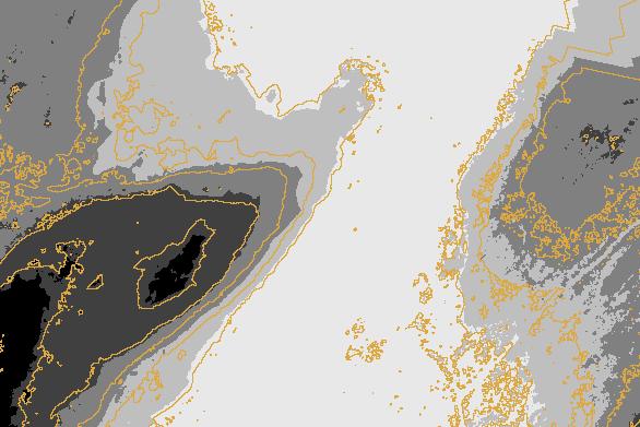
9 Comparing Standard Imagery to UAS Imagery Truck images displayed at the same relamve size but based on different image sources and resolumons ConvenMonal Aerial Photography 60cm High ResoluMon Aerial Photography 15cm UAS Aerial Photography 1.6cm


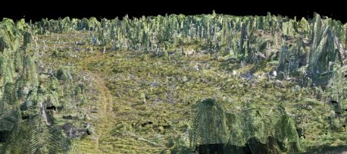
10 Point Clouds A set of data points In a 3 dimensional coordinates (x,y,z) Colour of each point can be included LIDAR and 3D scanning create point clouds Orthophoto image processing creates point clouds too Lets you look at imagery in a new way Virtual site tours, logismcs planning, volumetrics, etc. Copyright SRC 2014


11 RegulaMons and Constraints UAS treated similar to manned aircra: UAS cannot exceed 400 (122m) AGL Must maintain line of site (~500m) UAS cannot fly over built- up areas or inhabited buildings Must coordinate with ATC when close to aerodromes UAS flights require Special Flight OperaMons CerMficate (SFOC) SFOCs submimed prior to flight Can delay flights Blanket SFOCs for established pilots In future, pilots will require a license to operate These regulamons apply to commercial/business use of fixed- wing and rotorcra: UAS (including research/training)


12 Forestry ApplicaMons for UAS Block InspecMons AcMviMes Planning Compliance audits Boundary Mapping IdenMfy features easily missed during field cruise Document sites with pictures and orthophotos Live video focus on features of interest
 Highly accurate method of assessment Best in locamons where sites are unsafe Challenging for some types of measurements Understorey/lateral features Copyright")
13 Forestry ApplicaMons for UAS Ground Surveys (Area- based) AcMviMes RegeneraMon/FTG Surveys Soil disturbance mapping Harvest boundaries and silvicultural treatments Individual tree mapping (stand dynamics) Highly accurate method of assessment Best in locamons where sites are unsafe Challenging for some types of measurements Understorey/lateral features Copyright SRC 2014
")


14 Forestry ApplicaMons for UAS Ground Surveys (volume- based) AcMviMes Roadside/mill log inventories Chip/hog piles Accurate method of calculamng volume on the ground (volumetrics) 3D point clouds generated using so:ware Lateral measurements challenging Copyright SRC 2014


15 Forestry ApplicaMons for UAS Fire Hazard DetecMon AcMviMes Prescribed Burn Hog fuel hot spot detecmon Green Tree patch mapping Heat monitoring difficult on the ground IR Sensors on UAS ideal for smaller areas Safely reach inaccessible areas Manned aircra: should be used for large areas


16 UAS Benefits OperaMonal planning and repormng at the block level Timely, low cost for small areas Can be used for Planning Control Compliance PrescripMons Safety Can fly under cloud Small Area mapping made cost effecmve


17 UAS NegaMves Not for large areas Expensive for large areas Many flights needed Eyes on aircra:/line of site Weather Significant post- processing Transport Canada SFOCs Trained pilots Planning


18 Target Users Forest Industry and governments Visual inspecmons Automated applicamons Forestry Consultants Extension of current remote sensing applicamons More complex data processing Services for industry/government with no in- house UAS Research OrganizaMons Develop new uses/tools Copyright SRC 2014


19 UAS At FPI What is Happening? ROI exercise and Tech review Purchased rotorcra: in 2014 Work with industrial/provincial partners to define best applicamons ValidaMon Trials Visual inspecmon/reconnaissance RegeneraMon success/stocking Harvest mapping Wood pile/chip volumes PotenMal applicamon of IR Sensors Assistance for wood bidding Copyright SRC 2014


20 UAS At SRC What is Happening? Purchased fixed wing in 2013 Support for internal projects Island Forests Management Uranium mine reclamamon Providing client flight services Flight Management GPS Ground Control Image Processing Test different ways to use UAS Educate industry/government Future plans to test different sensors


21 Image Gallery Compare UAS Image ResoluMons Camera Fame Samples 5.0cm 4.0cm 4.0cm Copyright SRC cm 3.0cm 5.0cm 2.2cm 1.8cm 2.2cm 1.6cm 1.8cm 1.6cm


22 Image Gallery Cut- Block (4cm) Can you pick out a recent quad trail and flagging tape? Recent Quad Trail Flagging Tape Copyright SRC 2014


23 Imagery Gallery Forestry PlantaMon (3cm) Where s Waldo? There he is!


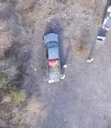
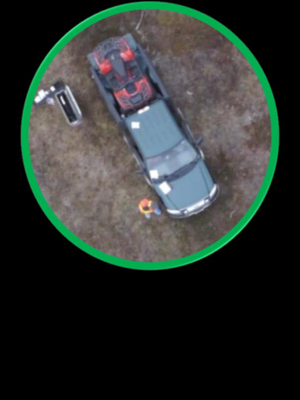
24 Imagery Gallery Forestry PlantaMon (1.8cm) Check out the details on the truck


25 Image Gallery Point Cloud of Abandoned Mine Site Look at this Image taken in Looking this way late 1950s Now viewed as a Point Cloud Based on this orthophoto Copyright SRC 2014

26 QuesMons?
Unmanned Aerial Vehicles for Environmental Applications
 Unmanned Aerial Vehicles for Environmental Applications John Rankin, President, J.R. Canadian Mapping Ltd. 10 th Annual Professional Biology Conference April 23 rd, 2015 UAVs Our System Suitable Sites
Drone Technology: What Works for Industry & Landowners. Michael J. Buschermohle Interim Assistant Dean UT Extension
 Drone Technology: What Works for Industry & Landowners Michael J. Buschermohle Interim Assistant Dean UT Extension So You Want to Fly FAA Regulations UAS Platforms Cameras Applications in Forestry Current
UAV/Drone Uses and Laws
 UAV/Drone Uses and Laws Robert Moorhead Director of Geosystems Research and Northern Gulf Institutes Professor of Electrical & Computer Engineering Unmanned Aerial Systems (UASs) 3 components to the system:
What is a UAS (Drone)
") UAS KCSI Aerial Patrol KCSI is Based in Bakersfield CA Established in 1993 Operates in 15 States KCSI has over 20 fulltime pilots Currently fly: Over 40,000 miles of pipeline a month 700 hours of production
UAS KCSI Aerial Patrol KCSI is Based in Bakersfield CA Established in 1993 Operates in 15 States KCSI has over 20 fulltime pilots Currently fly: Over 40,000 miles of pipeline a month 700 hours of production
Using UAS Technology for Invasive Plant Management
 Using UAS Technology for Invasive Plant Management Adam Benjamin, P.S.M. UF/IFAS Fort Lauderdale R.E.C. May 8, 2018 2018 Aquatic Weed Control Short Course Coral Springs, FL Using UAS Technology for Invasive
LAUNCHING YOUR UNMANNED AIRCRAFT PROGRAM
 LAUNCHING YOUR UNMANNED AIRCRAFT PROGRAM THE DARTDRONES TEAM UNMANNED AIRCRAFT APPLICATIONS AERIAL INSPECTIONS AERIAL INSPECTIONS Safer and faster alternative to visual inspection by an individual Damage
Presentation: UAS Helicopter Waran -1-
 Presentation: UAS Helicopter Waran -1- The unique design features of the Waran provide a superior payload capacity, prolonged endurance, stable flight patterns and a high degree of safety features. Technical
Civil Remotely Piloted Aircraft System (RPAS) Regulations in Australia
 Regulations in Australia") Civil Remotely Piloted Aircraft System (RPAS) Regulations in Australia Cees Bil School of Engineering RMIT University Melbourne AUSTRALIA bil@rmit.edu.au ICAS Workshop: Intelligent and Autonomous Technologies
Civil Remotely Piloted Aircraft System (RPAS) Regulations in Australia Cees Bil School of Engineering RMIT University Melbourne AUSTRALIA bil@rmit.edu.au ICAS Workshop: Intelligent and Autonomous Technologies
small Unmanned Aircraft Systems Arlington Police Department June 28, 2011
 suas small Unmanned Aircraft Systems Arlington Police Department June 28, 2011 1. Overview of APD suas program to date 2. Discuss the C.O.A. (FAA certificate of authorization to fly) and restrictions
Light UAS for forestry applications an Operational experience
 Light UAS for forestry applications an Operational experience European High Level Unmanned Aircraft Systems (UAS) Conferencen Lars Björk Swedish Forest Agency 1 Swedish Forest Agency Swedish Forest Agency
UAS to GIS Utilizing a low-cost Unmanned Aerial System (UAS) for Coastal Erosion Monitoring
 for Coastal Erosion Monitoring") UAS to GIS Utilizing a low-cost Unmanned Aerial System (UAS) for Coastal Erosion Monitoring Agenda Scope of today s presentation Demonstration Objectives Wrightsville Beach Test Area Masonboro Inlet Jetties
UAS to GIS Utilizing a low-cost Unmanned Aerial System (UAS) for Coastal Erosion Monitoring Agenda Scope of today s presentation Demonstration Objectives Wrightsville Beach Test Area Masonboro Inlet Jetties
OWEA Woolpert UAS Operations
 OWEA 2016 Woolpert UAS Operations UAS Rules and Regulations How Woolpert is Handling This The Exemption In December 2014 Woolpert received approval from the FAA regarding an exemption seeking relief from
UAV systems for cultural heritage HERICT ERASMUS IP Technical lecture 2
 UAV systems for cultural heritage HERICT ERASMUS IP Technical lecture 2 Dr. Dimitrios Skarlatos Lecturer Cyprus university of Technology Photogrammetric Vision Lab Dept. of Civil Eng. & Geomatics Dipl.
How to Use Drones in Stormwater Management January 17, :30 a.m. 11:30 a.m. (Eastern)
") Webinar Training Series How to Use Drones in Stormwater Management January 17, 2019 10:30 a.m. 11:30 a.m. (Eastern) www.seswa.org Today s Presenters Robert Gecy Application Programmer Beaufort County,
Webinar Training Series How to Use Drones in Stormwater Management January 17, 2019 10:30 a.m. 11:30 a.m. (Eastern) www.seswa.org Today s Presenters Robert Gecy Application Programmer Beaufort County,
FLYING YOUR DRONE FOR FUN?
 CAN I FLY THERE? Download CASA s free app showing nearby airports, helicopter landing sites, controlled airspace and restricted areas. For other remotely piloted aicraft enquiries, please contact CASA
In-field and Remote Sensing for Precision Agriculture. John Nowatzki Extension Ag Machine Systems Specialist North Dakota State University
 In-field and Remote Sensing for Precision Agriculture John Nowatzki Extension Ag Machine Systems Specialist North Dakota State University UAS in Precision Agriculture In-field Sensors Selecting UAS Equipment
Mapping with Unmanned Airborne Systems (UAS)
") Mapping with Unmanned Airborne Systems (UAS) February 13, 2014 Engineering Architecture Design-Build Surveying GeoSpatial Solutions Today s Agenda Introductions / Objectives Current UAS Regulations (FAA)
Mapping with Unmanned Airborne Systems (UAS) February 13, 2014 Engineering Architecture Design-Build Surveying GeoSpatial Solutions Today s Agenda Introductions / Objectives Current UAS Regulations (FAA)
2018 ENGINEERING EXPO Jon Thies NUAIR Director of Consulting
 2018 ENGINEERING EXPO Jon Thies NUAIR Director of Consulting Agenda Operating Under Current FAA Regulations suas Program Development Considerations suas Use Case Examples Quiz Regulations Small Unmanned
 Presented by: Lt. Michael J. Magda Team Leader, Firefighter, EMT -P, Hazardous Material Specialist, Private Pilot, Airframe & Power plant Mechanic Western Wayne County HMRT, Livonia Fire & Rescue And
A Drone s Eye View on Public Works Applications
 A Drone s Eye View on Public Works Applications APWA Construction Inspection Conference Parker, CO Jason Caldwell, VP of Business Development and Sales 2013, The Sanborn Map Company, Inc. Agenda Sanborn
UAS in Canada Stewart Baillie Chairman Unmanned Systems Canada Sept 2015
 UAS in Canada - 2015 Stewart Baillie Chairman Unmanned Systems Canada Sept 2015 My Focus Today.. Report on the growth of the UAS sector in Canada as a whole Provide background on UAS regulation in Canada
Program. - Flight Operations (VRI) Motivation. The Aircraft / Sensors. Unmanned Aircraft Systems 8/1/17
 Motivation. The Aircraft / Sensors. Unmanned Aircraft Systems 8/1/17") Program Unmanned Aircraft in Agriculture: Flight Operations and FAA Certification Process * 1) Background. Wayne Woldt, Ph.D., P.E. Department of Biological Systems Engineering School of Natural Resources
Program Unmanned Aircraft in Agriculture: Flight Operations and FAA Certification Process * 1) Background. Wayne Woldt, Ph.D., P.E. Department of Biological Systems Engineering School of Natural Resources
Unmanned Aerial Systems for Ozarks Agriculture
 Unmanned Aerial Systems for Ozarks Agriculture UAS, UAV, drone Next High Tech Tool for Agriculture and Beyond by Bob Schultheis Natural Resource Engineering Specialist Photo credit: http://modernfarmer.com/2014/01/precision
Unmanned Aerial Systems for Ozarks Agriculture
 Unmanned Aerial Systems for Ozarks Agriculture by Bob Schultheis Natural Resource Engineering Specialist for Webster County Cattle Producers Inc. Marshfield, MO February 11, 2016 1 UAS, UAV, drone Next
Adventures in UAS: Experiences of a UAS Operator. Paul Beckwith, PE, CCM, LEED AP bd+c Navigator CS, LLC, President. Presented by:
 Adventures in UAS: Experiences of a UAS Operator Presented by: Paul Beckwith, PE, CCM, LEED AP bd+c Navigator CS, LLC, President Paul Beckwith, PE, CCM, LEED AP bd+c BA in Architectural Engineering from
Development and Testing of an Unmanned Aircraft Safety Beacon for Aerial Application Safety
 Development and Testing of an Unmanned Aircraft Safety Beacon for Aerial Application Safety Wayne Woldt, Ph.D., P.E., and Jacob Smith Biological Systems Engineering and School of Natural Resources University
Unmanned Aircraft System (UAS): regulatory framework and challenges. NAM/CAR/SAM Civil - Military Cooperation Havana, Cuba, April 2015
: regulatory framework and challenges. NAM/CAR/SAM Civil - Military Cooperation Havana, Cuba, April 2015") Unmanned Aircraft System (UAS): regulatory framework and challenges NAM/CAR/SAM Civil - Military Cooperation Havana, Cuba, 13 17 April 2015 Overview Background Objective UAV? Assumptions Challenges Regulatory
Unmanned Aircraft System (UAS): regulatory framework and challenges NAM/CAR/SAM Civil - Military Cooperation Havana, Cuba, 13 17 April 2015 Overview Background Objective UAV? Assumptions Challenges Regulatory
Drone Pilot Course. Lesson 1 Study Guide- Regulations. Questions take from ASA Remote Pilot Test Prep Guide
 Lesson 1 Study Guide- Regulations 1. You are operating a 1280g (2.8lb) quadcopter for your own enjoyment. What FAA regulation is this suas operation subject to? a. 14 CFR 107 b. 14 CFR 101 2. You have
Australian Association for Unmanned Systems
 Australian Association for Unmanned Systems Industry Guidance on the Amended CASR 1998 Part 101 Version: 1.1 27 th May 2016 Background and Scope On the 30 th of March 2016 the Civil Aviation Safety Authority
ONE PLATFORM, MULTIPLE APPLICATIONS: SURVEYING CONSTRUCTION FORESTRY AGRICULTURE ENVIRONMENT POWER ENGINEERING BIRDIE YOUR TAILOR-MADE UAV
 UAV BIRDIE BIRDIE YOUR TAILOR-MADE UAV ONE PLATFORM, MULTIPLE APPLICATIONS: SURVEYING CONSTRUCTION FORESTRY AGRICULTURE ENVIRONMENT POWER ENGINEERING BIRDIE UAV is the complete mapping solution, made for
We're not spying on you; it's more interesting watching grass grow-
 We're not spying on you; it's more interesting watching grass grow- Using Unmanned Aircraft Systems in Rangeland Monitoring Connie Maxwell USDA Agricultural Research Service Jornada Experimental Range
Unmanned Aircraft Systems (UAS) at the Jornada Experimental Range
 at the Jornada Experimental Range") Unmanned Aircraft Systems (UAS) at the Jornada Experimental Range Al Rango and the Jornada UAS Flight Team: Connie Maxwell, Amy Slaughter, Andrea Laliberte, Chris Pierce, Dave Thatcher, Jim Lenz, and Craig
Unmanned Aircraft Systems (UAS) at the Jornada Experimental Range Al Rango and the Jornada UAS Flight Team: Connie Maxwell, Amy Slaughter, Andrea Laliberte, Chris Pierce, Dave Thatcher, Jim Lenz, and Craig
UNMANNED AIRCRAFT SYSTEMS (UAS) FOR PUBLIC POWER OPERATIONS AN OVERVIEW ON HOW DRONES ARE IMPACTING THE ENERGY INDUSTRY
 FOR PUBLIC POWER OPERATIONS AN OVERVIEW ON HOW DRONES ARE IMPACTING THE ENERGY INDUSTRY") UNMANNED AIRCRAFT SYSTEMS (UAS) FOR PUBLIC POWER OPERATIONS AN OVERVIEW ON HOW DRONES ARE IMPACTING THE ENERGY INDUSTRY ABOUT CHRISTOPHER TODD Founder and president of Airborne Response, Miamibased UAS
UNMANNED AIRCRAFT SYSTEMS (UAS) FOR PUBLIC POWER OPERATIONS AN OVERVIEW ON HOW DRONES ARE IMPACTING THE ENERGY INDUSTRY ABOUT CHRISTOPHER TODD Founder and president of Airborne Response, Miamibased UAS
Coeur d Alene Tribe GIS Unmanned Aerial System (UAS) Program JAMES TWOTEETH BERNE JACKSON GIOVAN ALCALA SABINE KRIER
 Program JAMES TWOTEETH BERNE JACKSON GIOVAN ALCALA SABINE KRIER") Coeur d Alene Tribe GIS Unmanned Aerial System (UAS) Program JAMES TWOTEETH BERNE JACKSON GIOVAN ALCALA SABINE KRIER What is an Unmanned Aerial System (UAS)? Small, unmanned aircraft under 50 lbs. remotely
Coeur d Alene Tribe GIS Unmanned Aerial System (UAS) Program JAMES TWOTEETH BERNE JACKSON GIOVAN ALCALA SABINE KRIER What is an Unmanned Aerial System (UAS)? Small, unmanned aircraft under 50 lbs. remotely
Using UAVs for Aerial Mapping, Surveying and Photography
 Using UAVs for Aerial Mapping, Surveying and Photography Prepared for: Central Florida GIS Workshop 18 September 2013 Kevin Shortelle System Dynamics International, Inc kevinshortelle@bellsouth.net Presentation
2017 PLSO Fall Seminar. UAV s Flying to Finished Product
 2017 PLSO Fall Seminar UAV s Flying to Finished Product Scott D. Kraner, P.E. Subject Matter Expert Civil Infrastructure Session Outline UAV Overview and Applications How to obtain a remote pilot certificate?
Commit to Safety: Professional Pilots Always Use a Checklist INITIAL EQUIPMENT SETUP
 Commit to Safety: Professional Pilots Always Use a Checklist INITIAL EQUIPMENT SETUP READ THE MANUAL Familiarize yourself with all aspects of your suas before you even consider going out for your first
Lone Star UAS Center. of Excellence and Innovation
 Lone Star UAS Center LSUASC Introduction of Excellence and Innovation Bringing UAS to America s Skies NASAO 85 th Annual Convention and Tradeshow UAS Emerging Technologies & Utilizations September 13,
Unmanned Aerial Vehicles or How I learned to stop worrying and love drones!
 Unmanned Aerial Vehicles or How I learned to stop worrying and love drones! Dr. Charles O Neill Aerospace Engineer, UA Professor, Pilot charles-oneill.com or aero.ua.edu Brief History of Drones German
Policies for Certification, operation and maintenance of UAS Andres Eduardo Parra Catama Air Safety Inspector Civil Aviation Authority of Colombia
 Policies for Certification, operation and maintenance of UAS Andres Eduardo Parra Catama Air Safety Inspector Civil Aviation Authority of Colombia Abstract: Civil Aviation Authority of Colombia currently
TABLE OF CONTENTS 1.0 INTRODUCTION...
 Advisory Circular Subject: General Safety Practices Model Aircraft and Unmanned Air Vehicle Systems Issuing Office: Civil Aviation, Standards Document No.: AC 600-02 File Classification No.: Z 5000-31
UAV Flight Services Company. What We Do. What Sets us Apart
 UAV Flight Services Company A dedicated team of aviators, technologists, and engineers. What We Do UAV flight services for data collection, mapping, and inspection What Sets us Apart Extensive field experience,
P310 VTOL UAV Operation Manual
 P310 VTOL UAV Operation Manual February, 2017 1 Shanghai Huace Navigation Technology Ltd. Contents 1.1 SYMBOLS DEFINITIONS... 4 1.2 TECHNICAL SUPPORT... 5 2.1 WARNING... 5 2.2 NOTICE... 5 4.1 GENERAL SPECIFICATIONS...
FUTURE DRIVEN BY TECHNOLOGY UNMANNED AERIAL SYSTEMS HOSTED BY CHAD E. COLBY FEBRUARY 18 TH How far we have come
 FUTURE DRIVEN BY TECHNOLOGY UNMANNED AERIAL SYSTEMS HOSTED BY CHAD E. COLBY FEBRUARY 18 TH 2015 How far we have come Growers are demanding MORE from every acre, this along with advances in Precision Technology
Launching a New Surveying Perspective
 Launching a New Surveying Perspective >> By Mary Jo Wagner A 3 km2 orthomosaic shows the entire construction site and surroundings. On the upper part of the mosaic are the Bristol Channel; the existing
UAV Program. What does it take to have a UAV Program Current Requirements Lemhi County UAV program
 UAV Program UAV Program What does it take to have a UAV Program Current Requirements Lemhi County UAV program What does it take to have a UAV program? Some Very Important Questions to Ask Before What type
The role of Unmanned Aircraft System (AUS) in search and rescue (SAR) operations
 in search and rescue (SAR) operations") The role of Unmanned Aircraft System (AUS) in search and rescue (SAR) operations Captain: Abdelkhalik Kamaleldin Soliman Selmy College of Maritime Transport & Technology Arab Academy for Science, Technology
The role of Unmanned Aircraft System (AUS) in search and rescue (SAR) operations Captain: Abdelkhalik Kamaleldin Soliman Selmy College of Maritime Transport & Technology Arab Academy for Science, Technology
The Flying Donkey Challenge
 The Flying Donkey Challenge Mission, rules, judging & rewards V1.2, 6th January 2014 (subject to regular updates and change) Contact details Fondation Bundi-Afrotech QIE.0 EPFL 1015 Lausanne Suisse fly@flyingdonkey.org
WEBINAR: A BIRD S-EYE VIEW
 WEBINAR: A BIRD S-EYE VIEW DRONES IN AGRIBUSINESS JUNE 21, 2016 Hosted by Nexsen Pruet Presented by Ernie Pearson (Nexsen Pruet); Patrick Lohman (PrecisionHawk); and Kyle Snyder (NGAT/NCSU) FOUNDED IN
Airworthiness considerations for UAVs
 A general overview about the approach to a UAV System under current regulations for operation, airspace and certification Presentation by : STN ATLAS ELEKTRONIK Klaus Wohlers, LMP Airborne Systems Type
Unmanned Aerial Systems for Agriculture
 Unmanned Aerial Systems for Agriculture by Bob Schultheis Natural Resource Engineering Specialist for Greene County Soils & Crops Conference Springfield, MO March 18, 2014 Special thanks to Bill Wiebold,
CAR PART VIII SUBPART 10 OPERATION OF UNMANNED AERIAL SYSTEMS WITHIN THE UNITED ARAB EMIRATES
 CAR PART VIII SUBPART 10 OPERATION OF UNMANNED AERIAL SYSTEMS WITHIN THE UNITED ARAB EMIRATES Issue no: Initial Page 1 of 21 Issue date: April 2015 FOREWORD 1- This is the initial issue of this regulation.
GUIDANCE FOR THE SAFE OPERATION OF MODEL AIRCRAFT, SMALL-UNMANNED AIRCRAFT AND SMALL UNMANNED SURVEILLANCE AIRCRAFT IN GUERNSEY AND ALDERNEY
 GUIDANCE FOR THE SAFE OPERATION OF MODEL AIRCRAFT, SMALL-UNMANNED AIRCRAFT AND SMALL UNMANNED SURVEILLANCE AIRCRAFT IN GUERNSEY AND ALDERNEY 1 Introduction 1.1 This document has been produced by Guernsey
LOW DOWN ON THE HIGH UP: USING DRONES FOR LAND CONSERVATION
 LOW DOWN ON THE HIGH UP: USING DRONES FOR LAND CONSERVATION TEXAS LAND CONSERVATION CONFERENCE MARCH 3, 2017 STEPHEN RAMIREZ STEWARDSHIP DIRECTOR TEXAS LAND CONSERVANCY RAY RENNER, RPLS, PMP MANAGER OF
The Legal Environment for Commercial Unmanned Aircraft
 The Legal Environment for Commercial Unmanned Aircraft Overview The Legal Environment Who can fly them? A history of FAA policy to the present Asking for permission 2 Today s Legal Framework 3 Today s
Requestor Information. Operator/Pilot Information. Owner Information
 Name: Department (if applicable): Email Address: Name of Supervisor (if applicable): Name of Operator/Pilot: Company Name (If applicable): Company Address: Requestor Information Operator/Pilot Information
Re: Exemption Request Section 333 of the FAA Reform Act and Part 11 of the Federal Aviation Regulations
 September 04, 2014 U. S. Department of Transportation Docket Management System 1200 New Jersey Ave., SE Washington, DC 20590 Re: Exemption Request Section 333 of the FAA Reform Act and Part 11 of the Federal
Ohio UAS Center - Enabling Flight 2016 Ohio Planning Conference Fred Judson, GISP UAS Program Director
 Ohio UAS Center - Enabling Flight 2016 Ohio Planning Conference Fred Judson, GISP UAS Program Director Fred.Judson@dot.state.oh.us How It Began (For Me) Formalization of GIS in the district. Implementation
UNMANNED AIRCRAFT SYSTEMS (UAS) IN UTILITIES
 IN UTILITIES") UNMANNED AIRCRAFT SYSTEMS (UAS) IN UTILITIES Presented by: Dan Carbone Avion Unmanned Why Drones? Why Drones? Cost Effective Entire cost of a UAS program can be recouped in first-year man-hour savings
UNMANNED AIRCRAFT SYSTEMS (UAS) IN UTILITIES Presented by: Dan Carbone Avion Unmanned Why Drones? Why Drones? Cost Effective Entire cost of a UAS program can be recouped in first-year man-hour savings
IAI - MALAT. IAI Unclassified
 IAI - MALAT Comprehensive UAS Solutions IAI Unclassified 1 Overview Malat is A World Leader in UAS Solutions Founded in 1974 50 customers worldwide More than 1000 UAVs produced and delivered Over 1,000,000
RISING PERFORMANCE. Civil aviation is an outlier. It s BY ERIK DAHLBERG
 RISING PERFORMANCE Compact mobile mapping systems can be installed on small passenger cars. Civil aviation is an outlier. It s among the few industries where tight government regulations are widely accepted
Intro to Small Unmanned Aircraft Systems & Recreational Drones
 Intro to Small Unmanned Aircraft Systems & Recreational Drones Controlled Airspace Controlled Airspace has defined dimensions within which Air Traffic Control (ATC) services are provided. The level of
ESA-EDA: Paving the Way for New UAS Capabilities in Europe
 ESA-EDA: Paving the Way for New UAS Capabilities in Europe Dr. Stefan Gustafsson, ESA Jens Fehler, EDA Noordwijk, 11 th 12 th May 2010 Integrated Application Promotion Earth Observation Telecommunication
Commercial UAS & the Impact of State Regulations Southern Legislative Conference July 20, 2015
 Commercial UAS & the Impact of State Regulations Southern Legislative Conference July 20, 2015 * Meet Ben 01 Currently the CEO of AgriSource Data; he was formerly the COO of VSG- Unmanned & has held leadership
EXAMPLE FLIGHT PLAN. Project Information UBC PRODUCTIONS APEX^ZERO. Prepared for: Paul Hodges Vice President, SFG Productions
 UBC PRODUCTIONS APEX^ZERO FLIGHT PLAN EXAMPLE Project Information Prepared for: Paul Hodges Vice President, SFG Productions Prepared by: Roger Apolinar & Eric Carpenter Remote Pilots in Command, APEX^ZERO
Excelsior Blanket Plus Granular vs. Dissolved PAM. What s On The Horizon? Richard A. McLaughlin, Ph.D. Professor and Extension Specialist 12/14/2015
 Excelsior Blanket Plus Granular vs. Dissolved PAM What s On The Horizon? Richard A. McLaughlin, Ph.D. Professor and Extension Specialist 1 Runoff Results: Turbidity No runoff Event 1 Rest period Event
UAS OPERATIONS AS AN ECOSYSTEM
 1 including photocopying, recording, or other electronic or mechanical methods, without the prior written permission of the content owner, The Unmanned Safety Institute, LLC. UAS OPERATIONS AS AN ECOSYSTEM
The Skyward Platform Helps You Manage UAV Operations
 The Skyward Platform Helps You Manage UAV Operations About Skyward Skyward s cloud-based UAV management platform powers scalable, efficient, safe, and insurable UAV operations for small businesses and
5 Day Operator Course. 1.0 AIRSPACE CLASSROOM ONLINE EXECUTIVE VO Terms X X Classification
 5 Day Operator Course 2 Day Executive Training 2 Day VO Training 0.1 INTRODUCTION CLASSROOM ONLINE EECUTIVE VO About Avion Solutions Purpose of the course Learning objectives Course outline and schedule
UAS in the ATM environment How can the new technologies reduce the impact of the UAS in non-segregated areas
 International Civil Aviation Organization UAS in the ATM environment How can the new technologies reduce the impact of the UAS in non-segregated areas Celso Figueiredo Regional Officer ATM/SAR ICAO South
GEOMATIC ASSESSMENT Membership Directory & Buyers Guide 97th Annual Conference Recap WINTER 2017/18
 WINTER 2017/18 GEOMATIC NC AWWA-WEA 3725 National Drive, Suite 217 Raleigh, NC 27612 ADDRESS SERVICE REQUESTED 2018 Membership Directory & Buyers Guide 97th Annual Conference Recap The official publication
Regulatory update. Unmanned Systems Canada. Charles Vidal. USC board member Director R&D and BD at KoptR
 Regulatory update Unmanned Systems Canada Charles Vidal USC board member Director R&D and BD at KoptR Charles.vidal@unmannedsystems.ca Charles.vidal@koptrimage.com Presentation Outline What is the regulation,
UNITED STATES OF AMERICA DEPARTMENT OF TRANSPORTATION FEDERAL AVIATION ADMINISTRATION WASHINGTON, DC
 UNITED STATES OF AMERICA DEPARTMENT OF TRANSPORTATION FEDERAL AVIATION ADMINISTRATION WASHINGTON, DC Regulatory Docket No. FAA-2007-3330-0001 IN THE MATTER OF THE PETITION FOR EXEMPTION OF: STEVEN MCDONALD
BEYOND VISUAL LINE OF SIGHT (BVLOS) UNMANNED AIR SYSTEMS (UAS) OPERATIONS IN EG D026 LULWORTH, Version 2
 UNMANNED AIR SYSTEMS (UAS) OPERATIONS IN EG D026 LULWORTH, Version 2") Ref: D026/CAP 1616 Airspace Design - STAGE 1 Date: 28 February 2018 BEYOND VISUAL LINE OF SIGHT (BVLOS) UNMANNED AIR SYSTEMS (UAS) OPERATIONS IN EG D026 LULWORTH, Version 2 Introduction 1. The Defence
Ref: D026/CAP 1616 Airspace Design - STAGE 1 Date: 28 February 2018 BEYOND VISUAL LINE OF SIGHT (BVLOS) UNMANNED AIR SYSTEMS (UAS) OPERATIONS IN EG D026 LULWORTH, Version 2 Introduction 1. The Defence
MODEL AERONAUTICAL ASSOCIATION OF AUSTRALIA
 MODEL AERONAUTICAL ASSOCIATION OF AUSTRALIA GENERAL RULES AND GUIDELINES FOR THE OPERATION OF MODEL AIRCRAFT MOP014 APPROVED: MAAA PRESIDENT Date: 31/10/2017 Paragraph 2.0 Definitions Brief description
DEFINITIONS DEFINITIONS 2/11/2017 REQUIREMENTS AND LIMITATIONS OF DRONE USE IN FORENSIC ACCIDENT RECONSTRUCTION
 REQUIREMENTS AND LIMITATIONS OF DRONE USE IN FORENSIC ACCIDENT RECONSTRUCTION ROGER BURGMEIER BURGMEIER CONSULTING INC. DEFINITIONS Aircraft: device that is used, or intended to be used, for flight. Drone:
NEW JERSEY COUNTIES EXCESS JOINT INSURANCE FUND 9 Campus Drive, Suite 216 Parsippany, NJ Telephone (201) BULLETIN NJCE 19-04
 BULLETIN NJCE 19-04") Date: January 1, 2019 NEW JERSEY COUNTIES EXCESS JOINT INSURANCE FUND 9 Campus Drive, Suite 216 Parsippany, NJ 07054 Telephone (201) 881-7632 BULLETIN NJCE 19-04 To: From: Re: Fund Commissioners of NJCE
Date: January 1, 2019 NEW JERSEY COUNTIES EXCESS JOINT INSURANCE FUND 9 Campus Drive, Suite 216 Parsippany, NJ 07054 Telephone (201) 881-7632 BULLETIN NJCE 19-04 To: From: Re: Fund Commissioners of NJCE
UNMANNED AERIAL SYSTEMS & THE AIRPORT SPONSOR
 UNMANNED AERIAL SYSTEMS & THE AIRPORT SPONSOR The Current Regulatory Framework And Practical Considerations May 7, 2016 Eric T. Smith Partner, Kaplan Kirsch & Rockwell Jonathan Cross Manager, Airport Law
Part 101, Amendment 7. Gyrogliders and Parasails, Unmanned Aircraft (including Balloons), Kites, and Rockets Operating Rules.
, Kites, and Rockets Operating Rules.") Part 101, Amendment 7 Gyrogliders and Parasails, Unmanned Aircraft (including Balloons), Kites, and Rockets Operating Rules Docket 14/CAR/3 Contents Rule objective... 3 Extent of consultation... 3 Summary
Part 101, Amendment 7 Gyrogliders and Parasails, Unmanned Aircraft (including Balloons), Kites, and Rockets Operating Rules Docket 14/CAR/3 Contents Rule objective... 3 Extent of consultation... 3 Summary
CHC P310 Operation Procedure
 CHC P310 Operation Procedure 1. GCS-202 Ground Control System Preparation a. Fix the location of GCS-202 b. Power on the GCS-202 and wait for the DGPS signal lock-in. Note: 1. if external power supply
Getting off the Ground: Implementing a Drone Program
 Getting off the Ground: Implementing a Drone Program November 2017 Steve Goldman, GISP GIS Manager / UAS Coordinator California Department of Fish and Wildlife http://www.wildlife.ca.gov Drones (UAS) What
Use of Drones (Unmanned Aerial Systems) for Agriculture
 for Agriculture") Photo credit: www.redorbit.com Photo credit: www.redorbit.com Use of Drones (Unmanned Aerial Systems) for Agriculture by Bob Schultheis Natural Resource Engineering Specialist for Ozarks Mini Maker Faire
Photo credit: www.redorbit.com Photo credit: www.redorbit.com Use of Drones (Unmanned Aerial Systems) for Agriculture by Bob Schultheis Natural Resource Engineering Specialist for Ozarks Mini Maker Faire
Advisory Circular. General Safety Practices Model Aircraft and Unmanned Air Vehicle Systems
 Advisory Circular Subject: General Safety Practices Model Aircraft and Unmanned Air Vehicle Systems Issuing Office: Civil Aviation, Standards Document No.: AC 600-002 File Classification No.: Z 5000-34
Why to be a drone pilot?
 DRONE PILOT ACADEMY Ludo Guisson works at SYNTRA Limburg as a business developer since 2003 for the development of training innovations with great economic potential. He himself was manned commercial helicopter
Application for a Special Flight Operations Certificate
 Application for a Special Flight Operations Certificate for a Large Unmanned High Altitude Balloon by Shaftesbury High School Shaftesbury High Altitude Robotics Project SHARP Date: November 1, 2013 Prepared
SPORT AVIATION CORP LTD
 SPORT AVIATION CORP LTD RECREATIONAL PILOT WRITTEN EXAMINATION Subcategory: Microlight No. 1 AIR LAW This examination paper remains the property of SAC Ltd and is protected by copyright. Name of Applicant:
AUGUST 2017 GNSS REVIEW. Survey Economics Chances of success. Mobile Mapping Airport scanning. Stag s Leap Winery Pre-construction plan
 AUGUST 2017 GNSS REVIEW Survey Economics Chances of success Stag s Leap Winery Pre-construction plan Mobile Mapping Airport scanning RISING PERFORMANCE» ERIK DAHLBERG Civil aviation is an outlier. It s
An Overview of UAS Technology, Current Research, and Perspective on Use
 An Overview of UAS Technology, Current Research, and Perspective on Use Eric N. Johnson Lockheed Martin Associate Professor of Avionics Integration Daniel Guggenheim School of Aerospace Engineering Georgia
High Precision Mapping From Long Endurance UAS. Gabe Ladd 4/10/14
 High Precision Mapping From Long Endurance UAS Gabe Ladd 4/10/14 Outline Test Missions Flown UAS Used For This Project Direct Mapping System Payload Data produced April 10, 2014 2014 American Aerospace
Potential Uses and Considerations Regarding the Use of UAS Technology in Assessment. January 2015 Frank Giuffrida
 Potential Uses and Considerations Regarding the Use of UAS Technology in Assessment January 2015 Frank Giuffrida Table of Contents Current climate surrounding UAS use... 2 Assessing the value of properties
State of the UAS Industry for Insurance and Construction
 State of the UAS Industry for Insurance and Construction A Drone by any Other Name There are many terms for drones in use today The industry is trying to shy away from drone verbiage since it has military
National Regulatory Profile
 National Regulatory Profile Finland NOTE : In this form the following terms are used Drone = Remotely Piloted Aircraft (RPA) = Unmanned Aircraft (UA) = See definition below Drone Pilot = Remote Pilot (RP)
UAS Overview IDOT s UAS Program
 Unmanned Aircraft Systems (UAS) UAS Overview IDOT s UAS Program Linda Schumm Bureau Chief Aviation Safety Linda.Schumm@Illinois.gov October 18, 2017 Bill Viste Project Coordinator William.Viste@Illinois.gov
fll,' The University of Georgia O tfo:c o f rh.: Vu:.: Pre,id.:nt for Research
 November 30, 2015 fll,' - - - ----- I M.$------- The University of Georgia ------------------9 O tfo:c o f rh.: Vu:.: Pre,id.:nt for Research U.S. Department of Transportation Docket Management System
Aerial Photography and Flight Planning
 Aerial Photography and Flight Planning What is VFR? Flight is to take place using visual references Must avoid clouds Normally have a distinguishable horizon Should have sight of the ground below, or in
Industria, Innovazione e Ricerca: Le nuove frontiere del volo a pilotaggio remoto
 Industria, Innovazione e Ricerca: Le nuove frontiere del volo a pilotaggio remoto Aniello Cozzolino Head of Research & Technology Development, Piaggio Aerospace University of Naples Federico II, June,
Unmanned Aerial Systems
 Unmanned Aerial Systems SIRIUS UAS Solar Farm Forestry Surveying Mines Stone Quarries Crop Damage Meadows Construction Sites Monitoring Mapping Documentation Peat Land Volume Calculation Innovation Made
Taney County Livestock and Forage Conference Forsyth, MO 2/8/2018
 Photo credit: www.redorbit.com Photo credit: www.redorbit.com Unmanned Aerial Systems (Drones) for Ozarks Agriculture by Bob Schultheis Natural Resource Engineering Specialist for Taney County Livestock
Unmanned Aerial Systems (Drones) for Ozarks Agriculture
 for Ozarks Agriculture") Unmanned Aerial Systems (Drones) for Ozarks Agriculture by Bob Schultheis Natural Resource Engineering Specialist for Taney County Livestock and Forage Conference Forsyth, MO February 8, 2018 1 Farming
Unmanned Aerial Systems (Drones) for Ozarks Agriculture by Bob Schultheis Natural Resource Engineering Specialist for Taney County Livestock and Forage Conference Forsyth, MO February 8, 2018 1 Farming
UAS Program. Todd Graetz Director, Technology Services UAS Program / Advanced Train Operations 1
 UAS Program Todd Graetz Director, Technology Services UAS Program / Advanced Train Operations 1 The elements of the program Business requirements Line of Sight (LOS) Implementation Applications Data/product