UAV Flight Services Company. What We Do. What Sets us Apart
|
|
|
- Damon Parks
- 5 years ago
- Views:
Transcription


1

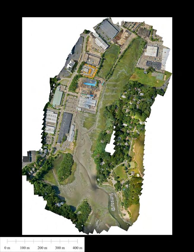
2 UAV Flight Services Company A dedicated team of aviators, technologists, and engineers. What We Do UAV flight services for data collection, mapping, and inspection What Sets us Apart Extensive field experience, strategic partnerships, and quick turnaround custom hardware & software solutions.


3 We help companies make critical business decisions faster, safer, and more cost effective through tightly integrated UAV data collection, processing, and presentation services.
4 THE PROCESS How it Works Initial Plan & Review Quote FLIGHT OPERATIONS Mission Planning Post Processing DATA DELIVERED

5 ...Work BACKWARD
6
7
8

9
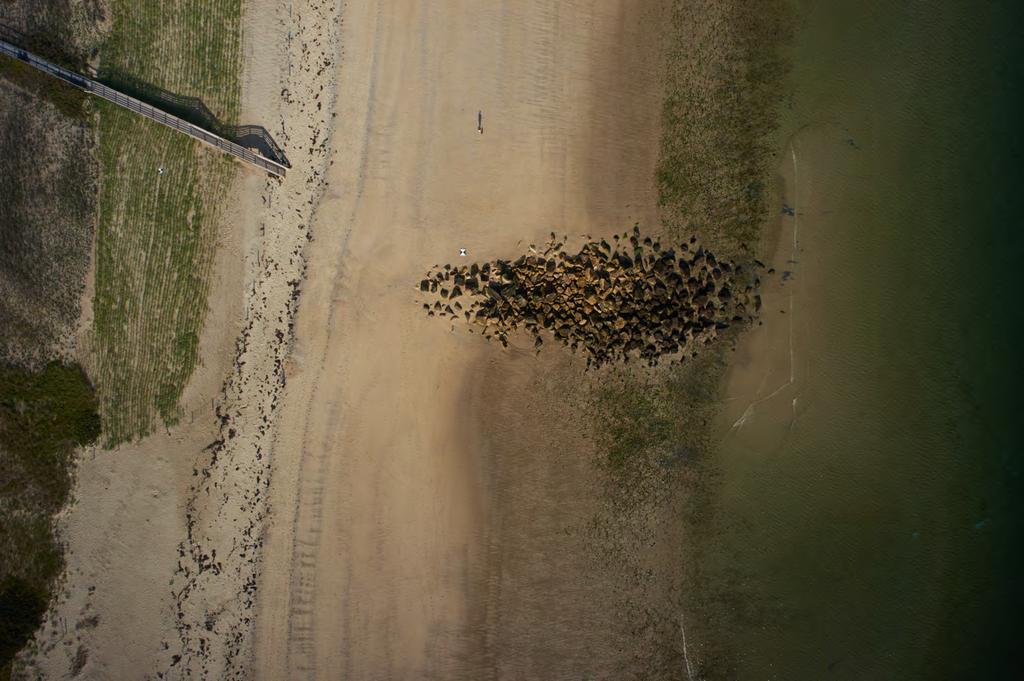
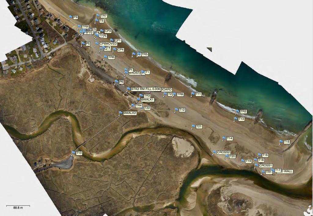
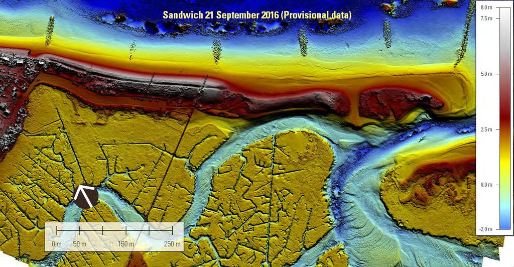
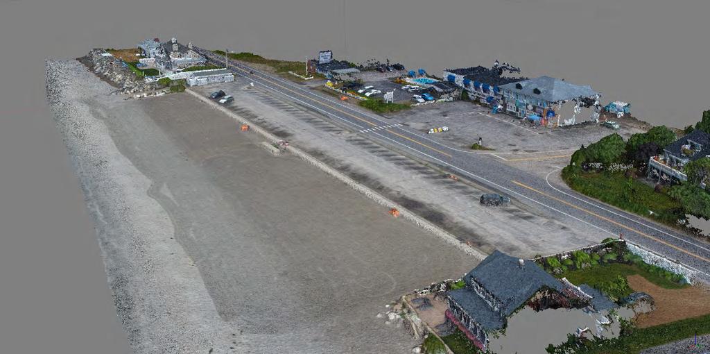
10 CHECKLIST For Contracting UAS Operations FAA Approval Insurance & Safety Experience Processing Section 333 or Part 17 Licensed Operators Authorizations for Specific Airspace Adequate Insurance Coverage Safety Plan & Operational Checklists Pre-Flight Briefing Situational Awareness Type of Aircraft Application Specific Hardware Software Data Types


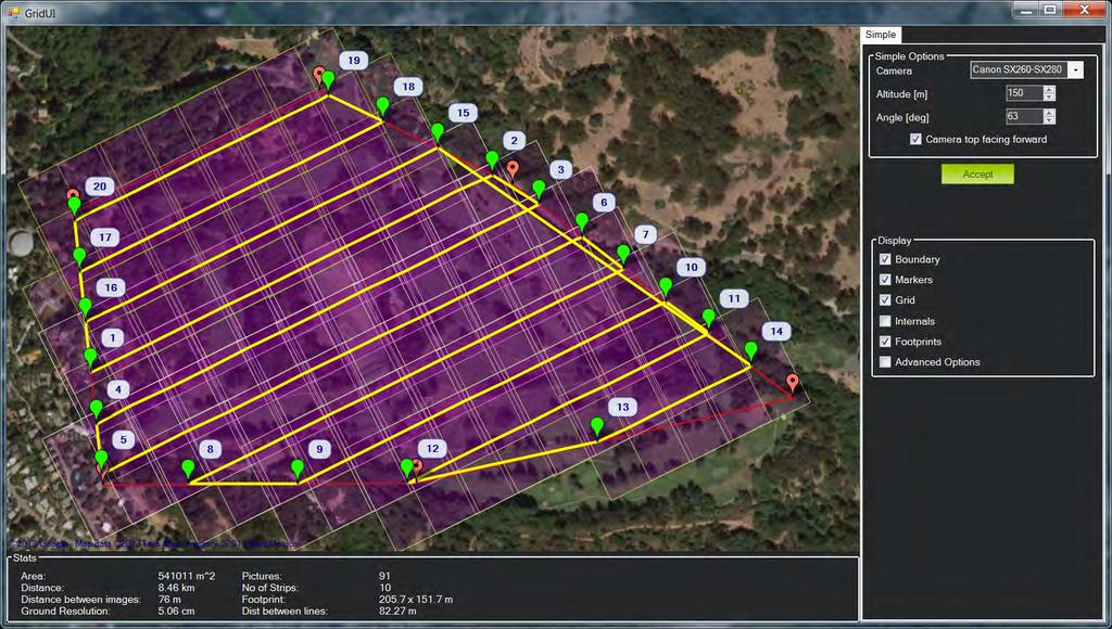
11 CAPABILITIES General Flight Considerations WIND & PRECIP UAV operations are best conducted on sunny or overcast days, when winds are <~15mph. Light precipitation is manageable, but avoided whenever possible. FLIGHT TIME Most UAV can fly for 15 3 minutes, and by combining flights can cover from tens to hundreds of acres. Fixed wing UAS can cover more area per flight, and should be used for larger mapping projects.


12 CONDITIONS Weather & Site Considerations TERRAIN & OBSTACLES Flat or rolling terrain with little tree cover is ideal for UAV mapping projects. Multirotors can operate out of smaller launch areas and operate closer to structures. TEMPERATURE UAVs can operate year round in almost any temperature, with the human operators being the largest concern. For most cases, use 1F as a guide.


13 OPERATIONAL CONSTRAINTS Simplified Rules for Planning Purposes LINE OF SIGHT UAS must remain within the operator s line of sight, in case of emergency. This also means operations must be conducted between dawn and dusk. AIRSPACE In most cases, commercial UAS must not operate within controlled airspace near airports, and are limited to 4FT above the ground & structures.

14 DATA What can be captured?


15 Sensors Current Future Viz IR LIDAR? VISIBLE IR & MULTISPECTRAL LIDAR OTHER High Resolution Still & Video Thermal & Multispectral Purchased Ranger MiniVUX from Phoenix LiDAR, April Delivery RTK GPS Gas Detectors Your Sensor Here


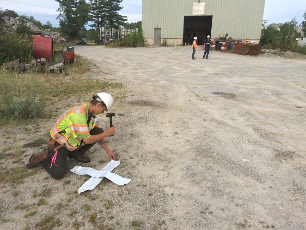
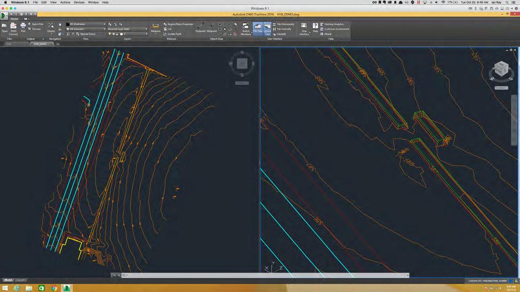
16 DATA TYPES Geotagged Imagery Point Clouds GIS CAD Geo-referenced still & video Photogrammetric point clouds in standard formats High resolution orthoimagery, multispectral & raster elevation models Contours & Basic Feature Extraction

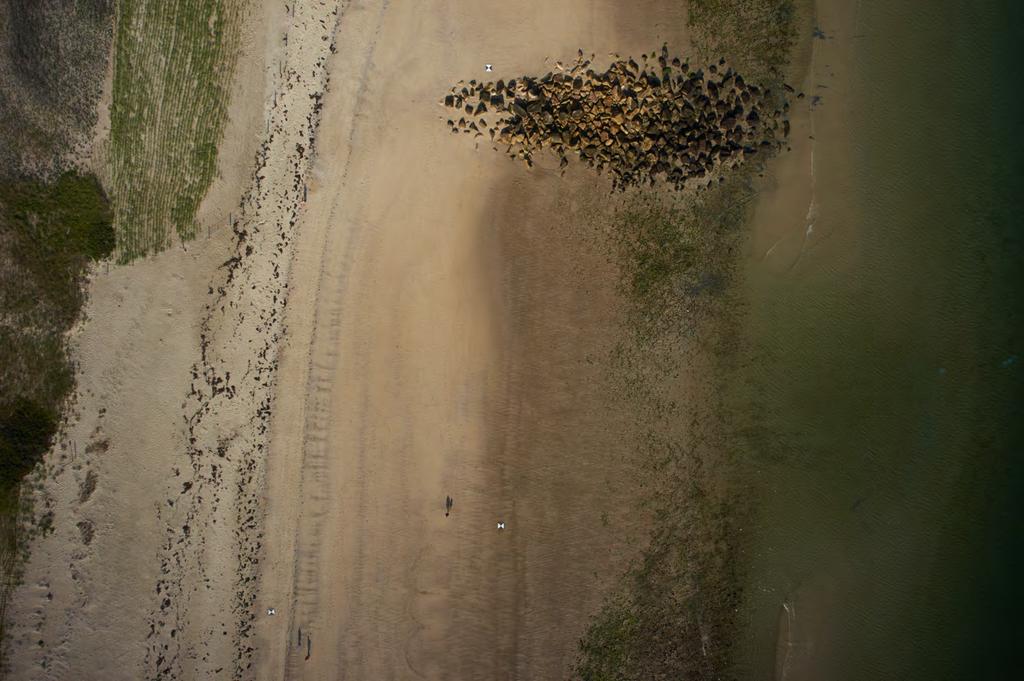
17 USGS Cape Cod Sandwich, MA Beach Erosion

18 Project documentation Community outreach Coastal erosion tracking Vegetation health
19
20
21
22

23 Control Point Target
24

25 Point Cloud Measurements

26 Digital Elevation Model
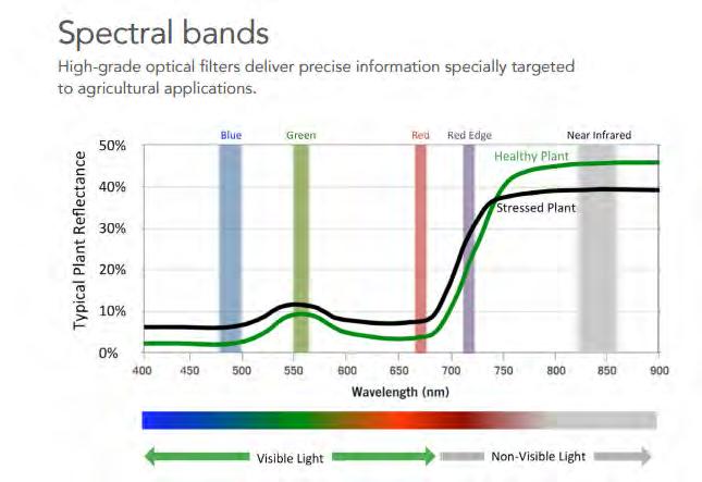
27
28 Jenness Beach UAV comparison vs. existing dataset
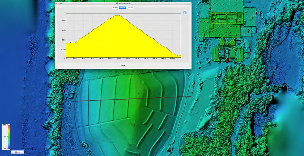
29
30

31 Control Point Targets
32 Feature Extraction

33 Feature Extraction
34 Multispectral - NDVI

35 Digital Elevation Model
36 Stockpile Volume Calculation
37 Cross-sectional Height Profile
38 81 Jericho Riverside Future Street Network Study Base Map RD L Peru fine sandy loam, to percent slopes, very stony ST Peru fine sandy loam, to 6 percent slopes, very stony HIL 786 PARK ` _ Limerick silt loam BS Colton and Stetson soils, to 3 percent slopes 766 CO JA Munson and Raynham silt loams, to 6 percent slopes Duane and Deerfield soils, to 5 percent slopes ,T he 4 Scantic silt loam, to percent slopes Cre ek 79 4 Q+A Thank You Livingston clay Muck and Peat Scantic silt loam, to percent slopes DEPOT ST R PL Legend GA Stetson gravelly fine sandy loam, to 5 percent slopes LN 756 RT Y LIB E LN HARVEST RUN PA LM ER 834 $ Utility Pole Electric Transmission Line 74 7 Vermont Gas 8 Topography - ft interval Feet Feet Stetson gravelly fine sandy loam, 1 to percent slopes Feet Stream Centerline 788 Water Body 69 VT R 6 OU TE Feet Hinesburg fine sandy loam, 15 to 5 percent slopes MAPLE RDG Groundwater Source Protection Area Vermont Significant Wetland Inventory FEMA Floodplain % Annual Chance Flood Hazard JERI HL EE K 7 69 CR SID E Special Flood Hazard Area 71 4 RD ANR River Corridor 6 7 Soil Map Unit Hazardous Waste Site Belgrade and Eldridge soils, to 3 percent slopes ST 6 ` _ 81 6 RK PA Public Drinking Water Sources 838 Lyman-Marlow very rocky loams, 5 to 3 percent slopes Colton and Stetson soils, 3 to 6 percent slopes Tax Parcel Boundary Stetson gravelly fine sandy loam, to 5 percent slopes ` _ RIVER 1:1, RD RD 4 N ST INSO 69 Belgrade and Eldridge soils, to 3 percent slopes 6 DICK Enosburg and Whately soils, to 3 percent slopes 4 Feet Source: Parcel Boundary - Jericho - 16; Underhill - 1 Imagery of project area - 16 procured by AirShark ANR River Corridor - January 14, see FEMA DFIRM floodplain data Disclaimer: The accuracy of information presented is determined by its sources. Errors and omissions may exist. The Chittenden Stetson gravelly fine sandy loam, 5 to 1 percent slopes Hadley very fine sandy loam $ + $ County Regional Planning Commission is not responsible for these. Questions of on-the-ground location can be resolved by site inspections and/or surveys by a registered surveyor. This map is not sufficient for delineation of features on-the-ground. This map identifies the presence of features, and may indicate relationships between features, but is not a replacement for surveyed information or engineering studies Colton and Stetson soils, to 3 percent slopes 676 Stetson gravelly fine sandy loam, to 5 percent slopes 67 Winooski very fine sandy loam ` _ Winooski very fine sandy loam Winooski very fine sandy loam Winooski very fine sandy loam WAY RACE 1// Document Path: D:\Projects16\Jericho\Sawmill_16113.mxd

39
40 CONTACT
LAUNCHING YOUR UNMANNED AIRCRAFT PROGRAM
 LAUNCHING YOUR UNMANNED AIRCRAFT PROGRAM THE DARTDRONES TEAM UNMANNED AIRCRAFT APPLICATIONS AERIAL INSPECTIONS AERIAL INSPECTIONS Safer and faster alternative to visual inspection by an individual Damage
UAS to GIS Utilizing a low-cost Unmanned Aerial System (UAS) for Coastal Erosion Monitoring
 for Coastal Erosion Monitoring") UAS to GIS Utilizing a low-cost Unmanned Aerial System (UAS) for Coastal Erosion Monitoring Agenda Scope of today s presentation Demonstration Objectives Wrightsville Beach Test Area Masonboro Inlet Jetties
UAS to GIS Utilizing a low-cost Unmanned Aerial System (UAS) for Coastal Erosion Monitoring Agenda Scope of today s presentation Demonstration Objectives Wrightsville Beach Test Area Masonboro Inlet Jetties
Unmanned Aerial Vehicles for Environmental Applications
 Unmanned Aerial Vehicles for Environmental Applications John Rankin, President, J.R. Canadian Mapping Ltd. 10 th Annual Professional Biology Conference April 23 rd, 2015 UAVs Our System Suitable Sites
How to Use Drones in Stormwater Management January 17, :30 a.m. 11:30 a.m. (Eastern)
") Webinar Training Series How to Use Drones in Stormwater Management January 17, 2019 10:30 a.m. 11:30 a.m. (Eastern) www.seswa.org Today s Presenters Robert Gecy Application Programmer Beaufort County,
Webinar Training Series How to Use Drones in Stormwater Management January 17, 2019 10:30 a.m. 11:30 a.m. (Eastern) www.seswa.org Today s Presenters Robert Gecy Application Programmer Beaufort County,
AUGUST 2017 GNSS REVIEW. Survey Economics Chances of success. Mobile Mapping Airport scanning. Stag s Leap Winery Pre-construction plan
 AUGUST 2017 GNSS REVIEW Survey Economics Chances of success Stag s Leap Winery Pre-construction plan Mobile Mapping Airport scanning RISING PERFORMANCE» ERIK DAHLBERG Civil aviation is an outlier. It s
What is a UAS (Drone)
") UAS KCSI Aerial Patrol KCSI is Based in Bakersfield CA Established in 1993 Operates in 15 States KCSI has over 20 fulltime pilots Currently fly: Over 40,000 miles of pipeline a month 700 hours of production
UAS KCSI Aerial Patrol KCSI is Based in Bakersfield CA Established in 1993 Operates in 15 States KCSI has over 20 fulltime pilots Currently fly: Over 40,000 miles of pipeline a month 700 hours of production
RISING PERFORMANCE. Civil aviation is an outlier. It s BY ERIK DAHLBERG
 RISING PERFORMANCE Compact mobile mapping systems can be installed on small passenger cars. Civil aviation is an outlier. It s among the few industries where tight government regulations are widely accepted
UNMANNED AIRCRAFT SYSTEMS (UAS) IN UTILITIES
 IN UTILITIES") UNMANNED AIRCRAFT SYSTEMS (UAS) IN UTILITIES Presented by: Dan Carbone Avion Unmanned Why Drones? Why Drones? Cost Effective Entire cost of a UAS program can be recouped in first-year man-hour savings
UNMANNED AIRCRAFT SYSTEMS (UAS) IN UTILITIES Presented by: Dan Carbone Avion Unmanned Why Drones? Why Drones? Cost Effective Entire cost of a UAS program can be recouped in first-year man-hour savings
UAS Implementation at Duke Energy
 UAS Implementation at Duke Energy Cross-Functional Team Approach Aviation Corporate Communications Emerging Technology External Counsel Insurance/Risk Internal Counsel Supply Chain Various BU Stakeholders/SME
Hazard Identification Questionnaire
 Hazard Identification Questionnaire OVERVIEW This questionnaire is designed to help identify potential risks and help identify areas of risk exposure. It is not an exhaustive list. This questionnaire is
Preliminary Site Evaluation
 Preliminary Site Evaluation 100 Acre Site, US 72 Piperton, Tennessee Power Distributor: Chickasaw Electric Cooperative August 2010 SITE DATA SHEET PIPERTON US 72 SITE (100 ACRES): LOCATION & GENERAL DESCRIPTION
Drone Technology: What Works for Industry & Landowners. Michael J. Buschermohle Interim Assistant Dean UT Extension
 Drone Technology: What Works for Industry & Landowners Michael J. Buschermohle Interim Assistant Dean UT Extension So You Want to Fly FAA Regulations UAS Platforms Cameras Applications in Forestry Current
Commit to Safety: Professional Pilots Always Use a Checklist INITIAL EQUIPMENT SETUP
 Commit to Safety: Professional Pilots Always Use a Checklist INITIAL EQUIPMENT SETUP READ THE MANUAL Familiarize yourself with all aspects of your suas before you even consider going out for your first
Unmanned Aerial Systems for Agriculture
 Unmanned Aerial Systems for Agriculture by Bob Schultheis Natural Resource Engineering Specialist for Greene County Soils & Crops Conference Springfield, MO March 18, 2014 Special thanks to Bill Wiebold,
GEOMATIC ASSESSMENT Membership Directory & Buyers Guide 97th Annual Conference Recap WINTER 2017/18
 WINTER 2017/18 GEOMATIC NC AWWA-WEA 3725 National Drive, Suite 217 Raleigh, NC 27612 ADDRESS SERVICE REQUESTED 2018 Membership Directory & Buyers Guide 97th Annual Conference Recap The official publication
Outline Why CCSU PinnaclX and Eversource
 CBIA 2018 Safety & Health Conference Wednesday, May 23, 2018 The Red Lion Hotel Cromwell 100 Berlin Road, Cromwell, CT Drones & Safety: A Brave New World Alfred A. Gates, Ph.D. CFI Helicopter, UAS Remote
Lone Star UAS Center. of Excellence and Innovation
 Lone Star UAS Center LSUASC Introduction of Excellence and Innovation Bringing UAS to America s Skies NASAO 85 th Annual Convention and Tradeshow UAS Emerging Technologies & Utilizations September 13,
DRONING FOR INFORMATION
 DRONING FOR INFORMATION Opportunity of Drones for Surveying and Mapping Practices By: Adam Smith, CP Matt Aguirre, PLS Overview Introduction Background Problem and Opportunity Issues and Mitigations Implementation
2018 ENGINEERING EXPO Jon Thies NUAIR Director of Consulting
 2018 ENGINEERING EXPO Jon Thies NUAIR Director of Consulting Agenda Operating Under Current FAA Regulations suas Program Development Considerations suas Use Case Examples Quiz Regulations Small Unmanned
Needs for UAS in Response
 UAS Potential Uses and Limitations October 21, 2015 Michele Jacobi Office Response and Restoration 10/27/2015 1 Needs for UAS in Response Limited access to areas of interest (distance, safety concerns,
UAS Overview IDOT s UAS Program
 Unmanned Aircraft Systems (UAS) UAS Overview IDOT s UAS Program Linda Schumm Bureau Chief Aviation Safety Linda.Schumm@Illinois.gov October 18, 2017 Bill Viste Project Coordinator William.Viste@Illinois.gov
Net of Innovation. July 2015 Dave Finger, Mark Foster
 Net of Innovation July 2015 Dave Finger, Mark Foster Table of Contents The Challenges and Solutions to Safe Outdoor Testing... 2 Types of Testing a Netted Enclosure Enables... 4 Flight Plan Testing...
Drones in Construction: Beyond Pictures Capturing and Exploring Actionable Data
 Drones in Construction: Beyond Pictures Capturing and Exploring Actionable Data Hunter Cole & Jesse Creech Virtual Design + Construction Brasfield & Gorrie General Contractors Join the conversation #AU2016
Mapping with Unmanned Airborne Systems (UAS)
") Mapping with Unmanned Airborne Systems (UAS) February 13, 2014 Engineering Architecture Design-Build Surveying GeoSpatial Solutions Today s Agenda Introductions / Objectives Current UAS Regulations (FAA)
Mapping with Unmanned Airborne Systems (UAS) February 13, 2014 Engineering Architecture Design-Build Surveying GeoSpatial Solutions Today s Agenda Introductions / Objectives Current UAS Regulations (FAA)
MORGAN CREEK GREENWAY Final Report APPENDICES
 APPENDICES MORGAN CREEK GREENWAY Appendix A Photos of Existing Conditions in Trail Corridor Photos of existing conditions Main trail corridor - February 2009 Photos of existing conditions south bank Morgan
Operational Evaluation of a Flight-deck Software Application
 Operational Evaluation of a Flight-deck Software Application Sara R. Wilson National Aeronautics and Space Administration Langley Research Center DATAWorks March 21-22, 2018 Traffic Aware Strategic Aircrew
A Drone s Eye View on Public Works Applications
 A Drone s Eye View on Public Works Applications APWA Construction Inspection Conference Parker, CO Jason Caldwell, VP of Business Development and Sales 2013, The Sanborn Map Company, Inc. Agenda Sanborn
Hidalgo County Drone Program. Standard Operating Procedure (SOP) Template. February 23, 2017
 Template. February 23, 2017") Hidalgo County Drone Program Standard Operating Procedure (SOP) Template The following is a detailed (but intended as a comprehensive) framework of topics to be covered in a Standard Operating Procedure
Hidalgo County Drone Program Standard Operating Procedure (SOP) Template The following is a detailed (but intended as a comprehensive) framework of topics to be covered in a Standard Operating Procedure
UAS Unmanned Aircra: Systems in Forest Management
 UAS Unmanned Aircra: Systems in Forest Management UAS What are they? Unmanned Aircra: Systems (UAS) fill niche built upon military UAV technologies Most common plahorms Fixed Wing Rotorcra: Primary uses
LOW DOWN ON THE HIGH UP: USING DRONES FOR LAND CONSERVATION
 LOW DOWN ON THE HIGH UP: USING DRONES FOR LAND CONSERVATION TEXAS LAND CONSERVATION CONFERENCE MARCH 3, 2017 STEPHEN RAMIREZ STEWARDSHIP DIRECTOR TEXAS LAND CONSERVANCY RAY RENNER, RPLS, PMP MANAGER OF
Program. - Flight Operations (VRI) Motivation. The Aircraft / Sensors. Unmanned Aircraft Systems 8/1/17
 Motivation. The Aircraft / Sensors. Unmanned Aircraft Systems 8/1/17") Program Unmanned Aircraft in Agriculture: Flight Operations and FAA Certification Process * 1) Background. Wayne Woldt, Ph.D., P.E. Department of Biological Systems Engineering School of Natural Resources
Program Unmanned Aircraft in Agriculture: Flight Operations and FAA Certification Process * 1) Background. Wayne Woldt, Ph.D., P.E. Department of Biological Systems Engineering School of Natural Resources
Getting off the Ground: Implementing a Drone Program
 Getting off the Ground: Implementing a Drone Program November 2017 Steve Goldman, GISP GIS Manager / UAS Coordinator California Department of Fish and Wildlife http://www.wildlife.ca.gov Drones (UAS) What
UNMANNED AIRCRAFT SYSTEMS (UAS) FOR PUBLIC POWER OPERATIONS AN OVERVIEW ON HOW DRONES ARE IMPACTING THE ENERGY INDUSTRY
 FOR PUBLIC POWER OPERATIONS AN OVERVIEW ON HOW DRONES ARE IMPACTING THE ENERGY INDUSTRY") UNMANNED AIRCRAFT SYSTEMS (UAS) FOR PUBLIC POWER OPERATIONS AN OVERVIEW ON HOW DRONES ARE IMPACTING THE ENERGY INDUSTRY ABOUT CHRISTOPHER TODD Founder and president of Airborne Response, Miamibased UAS
UNMANNED AIRCRAFT SYSTEMS (UAS) FOR PUBLIC POWER OPERATIONS AN OVERVIEW ON HOW DRONES ARE IMPACTING THE ENERGY INDUSTRY ABOUT CHRISTOPHER TODD Founder and president of Airborne Response, Miamibased UAS
Using UAVs for Aerial Mapping, Surveying and Photography
 Using UAVs for Aerial Mapping, Surveying and Photography Prepared for: Central Florida GIS Workshop 18 September 2013 Kevin Shortelle System Dynamics International, Inc kevinshortelle@bellsouth.net Presentation
Navigation Instruction Manual Additional manual to the standard instruction manual
 Release 1.0 for CoMo softwareupdate 1.40 Navigation Instruction Manual Additional manual to the standard instruction manual z WP 5 Takeoff WP 8 x WP 12 landing place y IMPORTANT: Alt2 MUST be setup correctly
Appendix C AIRPORT LAYOUT PLANS
 Appendix C AIRPORT LAYOUT PLANS Appendix C AIRPORT LAYOUT PLANS Airport Master Plan Santa Barbara Airport As part of this Airport Master Plan, the Federal Aviation Administration (FAA) requires the development
Emergency Operations Plan Annex E: Helicopter Crash
 I. Introduction General Since 1987, over 265 MEDEVAC aircraft have crashed with an annual peak occurring in 2008 in which 7 crashes occurred in that year killing 28 people. Factors contributing to the
Town of Scarborough, Maine Parcel Report
 Town of Scarborough, Maine Parcel Report Map/Lot Number R017005 Parcel Information Report generated: 10/4/2012 8:19:58 AM Account Number: 298 Parcel Type: Parcel Map/Lot Number: R017005 Parent Lot: R017005
th Ave. SW I Minot, ND, I
 1020 20 th Ave. SW I Minot, ND, 58701 www.minotusa.com I 701.852.1075 MAGIC Sky Initiative White Paper Introduction The Unmanned Aerial Systems (UAS) industry is an emerging industry that has experienced
OWEA Woolpert UAS Operations
 OWEA 2016 Woolpert UAS Operations UAS Rules and Regulations How Woolpert is Handling This The Exemption In December 2014 Woolpert received approval from the FAA regarding an exemption seeking relief from
UAV/Drone Uses and Laws
 UAV/Drone Uses and Laws Robert Moorhead Director of Geosystems Research and Northern Gulf Institutes Professor of Electrical & Computer Engineering Unmanned Aerial Systems (UASs) 3 components to the system:
UAV systems for cultural heritage HERICT ERASMUS IP Technical lecture 2
 UAV systems for cultural heritage HERICT ERASMUS IP Technical lecture 2 Dr. Dimitrios Skarlatos Lecturer Cyprus university of Technology Photogrammetric Vision Lab Dept. of Civil Eng. & Geomatics Dipl.
Trail Assessment Report
 Trail Assessment Report Trail Options for the Bear Creek Canyon located in Pikes Peak Ranger District, Pike National Forest and on Colorado Springs Utility Lands Due to the presence of a unique species
Potential Uses and Considerations Regarding the Use of UAS Technology in Assessment. January 2015 Frank Giuffrida
 Potential Uses and Considerations Regarding the Use of UAS Technology in Assessment January 2015 Frank Giuffrida Table of Contents Current climate surrounding UAS use... 2 Assessing the value of properties
PLANNING CONSIDERATIONS
 12TH NOGALES PARK TUCSON ALVERNON SWAN WILMOT CAMPBELL DREXEL COUNTRY CLUB LEGEND RESERVE LAND AREA (APPROXIMATE) POTENTIAL FUTURE HSR TO AIRPORT TRANSIT CONNECTIONS VALENCIA PIMA COUNTY CITY OF TUCSON
Regional implementation of Electronic Terrain and Obstacle data (e-tod) (Presented by Jeppesen)
 (Presented by Jeppesen)") International Civil Aviation Organization SAM/IG/13-WP/39 South American Regional Office 5/04/14 Thirteenth Workshop/Meeting of the SAM Implementation Group English only (SAM/IG/13) - Regional Project
International Civil Aviation Organization SAM/IG/13-WP/39 South American Regional Office 5/04/14 Thirteenth Workshop/Meeting of the SAM Implementation Group English only (SAM/IG/13) - Regional Project
Platform and Products
 International Partnership Space Programme Earth Observation for the Preservation of Ecological Bacalar Corridor Platform and Products Terri Freemantle, Raffaella Guida, Paula Marti, Pasquale Iervolino
Using LiDAR for Precise Vegetation Management
 Using LiDAR for Precise Vegetation Management Quantum Spatial is a proven partner to airport planners, engineers, facility managers, and contractors whose objective is to build, expand, and make improvements
KTRK Flight Tracking System, VNOMS, Altitudes and Positional Calculations
 KTRK Flight Tracking System, VNOMS, Altitudes and Positional Calculations Prepared by: Joseph A. LaMacchia August 17, 2015 Proprietary Information 1 Noise Complaint Details VNOMS Data and Flight Path Flight
Development and Testing of an Unmanned Aircraft Safety Beacon for Aerial Application Safety
 Development and Testing of an Unmanned Aircraft Safety Beacon for Aerial Application Safety Wayne Woldt, Ph.D., P.E., and Jacob Smith Biological Systems Engineering and School of Natural Resources University
Delta Air Lines, Inc. How Airports and Airlines Can Enhance Collaboration in Operations
 Delta Air Lines, Inc. How Airports and Airlines Can Enhance Collaboration in Operations April 20, 2016 Kirk Thornburg Vice President, Aviation Safety and Corporate Quality Compliance Delta Internal Perspective
Launching a New Surveying Perspective
 Launching a New Surveying Perspective >> By Mary Jo Wagner A 3 km2 orthomosaic shows the entire construction site and surroundings. On the upper part of the mosaic are the Bristol Channel; the existing
From AIS To AIM. Agenda. Agenda. Jack Hsu Mark Varellas
 Agenda Agenda From AIS To AIM 1. Introduction to MDA 2. What is AIS to AIM? 3. FAA Approach to AIM 4. AIM Transition Planning 5. ext Steps 1. Introduction to MDA 2. What is AIS to AIM? 3. FAA Approach
A GIS Analysis of Probable High Recreation Use Areas in Three Sisters Wilderness Deschutes and Willamette National Forests
 Lindsey Kiesz Geo 565 Term Project 3/15/2010 A GIS Analysis of Probable High Recreation Use Areas in Three Sisters Wilderness Deschutes and Willamette National Forests Introduction The Three Sisters Wilderness
small Unmanned Aircraft Systems Arlington Police Department June 28, 2011
 suas small Unmanned Aircraft Systems Arlington Police Department June 28, 2011 1. Overview of APD suas program to date 2. Discuss the C.O.A. (FAA certificate of authorization to fly) and restrictions
UAV Program. What does it take to have a UAV Program Current Requirements Lemhi County UAV program
 UAV Program UAV Program What does it take to have a UAV Program Current Requirements Lemhi County UAV program What does it take to have a UAV program? Some Very Important Questions to Ask Before What type
1.0 Project Background Mission Statement and Goals Objectives of this Sustainable Master Plan
 TABLE OF CONTENTS CHAPTER 1 INTRODUCTION 10 Project Background 1-1 11 Mission Statement and Goals 1-1 12 Objectives of this Sustainable Master Plan 1-2 CHAPTER 2 INVENTORY 20 Airport Background 2-1 201
PHOENIX AIR UNMANNED, LLC
 PHOENIX AIR UNMANNED, LLC A COMMITMENT TO EXCELLENCE IN UNMANNED AVIATION Based north of Atlanta in Cartersville, Georgia, Phoenix Air Unmanned, LLC (PAU) is a sister company of the internationally recognized
CHECKLIST DJI MAVIC PRO
 CHECKLIST DJI MAVIC PRO BEFORE GOING OUT 1. Verify NOTAM 2. Airspace clearance CLEARED 3. Mission accepted by HFO ACCEPTED 4. Weather forecast 5. Airworthiness 6. Onboard battery voltage 7. RC-control
5 Day Operator Course. 1.0 AIRSPACE CLASSROOM ONLINE EXECUTIVE VO Terms X X Classification
 5 Day Operator Course 2 Day Executive Training 2 Day VO Training 0.1 INTRODUCTION CLASSROOM ONLINE EECUTIVE VO About Avion Solutions Purpose of the course Learning objectives Course outline and schedule
Unmanned Aircraft Systems in Disaster Management and National Preparedness
 Unmanned Aircraft Systems in Disaster Management and National Preparedness at the Hawaii Land Surveyors Association Matt Kobayashi Ted Ralston National Disaster Preparedness Training Center Honolulu Why
Request for Proposal National Tropical Botanical Garden Lower Limahuli Preserve Emergency Stream Debris Removal
 Request for Proposal National Tropical Botanical Garden Lower Limahuli Preserve Emergency Stream Debris Removal I. Summary of Work Bids are solicited for the emergency removal of debris deposited in the
Unmanned Aircraft Systems (UAS) 101
 101") Unmanned Aircraft Systems (UAS) 101 Presented to: The American Association of State Highway and Transportation Officials Presented by: Dave May, FAA UAS Integration Office Date: What is a UAS? A UAS is
Unmanned Aircraft Systems (UAS) 101 Presented to: The American Association of State Highway and Transportation Officials Presented by: Dave May, FAA UAS Integration Office Date: What is a UAS? A UAS is
1.1.3 Taxiways. Figure 1-15: Taxiway Data. DRAFT Inventory TYPICAL PAVEMENT CROSS-SECTION LIGHTING TYPE LENGTH (FEET) WIDTH (FEET) LIGHTING CONDITION
 WIDTH (FEET) LIGHTING CONDITION") 1.1.3 Taxiways EWN has an extensive network of taxiways and taxilanes connecting the terminal, air cargo, and general aviation areas with the runways as listed in Figure 1-15. A 50-foot wide parallel taxiway
1.1.3 Taxiways EWN has an extensive network of taxiways and taxilanes connecting the terminal, air cargo, and general aviation areas with the runways as listed in Figure 1-15. A 50-foot wide parallel taxiway
BAe-146 Next Generation Airtanker Frequently Asked Questions. Q. Why do you have to download on retardant at some airtanker bases?
 BAe-146 Next Generation Airtanker Frequently Asked Questions Q. Why do you have to download on retardant at some airtanker bases? Density Altitudes affect all aircraft. During the fire season, it is not
Innovations in Aviation Flow Management REDUCING CONGESTION AND INCREASING CAPACITY
 Innovations in Aviation Flow Management REDUCING CONGESTION AND INCREASING CAPACITY Introduction With passenger volumes rising steadily, the global aviation system is facing a challenge: How to accommodate
WEBINAR: A BIRD S-EYE VIEW
 WEBINAR: A BIRD S-EYE VIEW DRONES IN AGRIBUSINESS JUNE 21, 2016 Hosted by Nexsen Pruet Presented by Ernie Pearson (Nexsen Pruet); Patrick Lohman (PrecisionHawk); and Kyle Snyder (NGAT/NCSU) FOUNDED IN
Jeppesen Total Navigation Solution
 Jeppesen Total Navigation Solution Executive summary Do more with less. It s a challenge we all face, and it s the reality of military operations. Jeppesen s Total Navigation Solution (TNS) gives you enterprise,
FAA Update. Dakota-Minnesota (DMA) Airports District Office. Federal Aviation Administration. Presented to: By: Date: South Dakota Airports Conference
 Airports District Office. Federal Aviation Administration. Presented to: By: Date: South Dakota Airports Conference") FAA Update Dakota-Minnesota (DMA) Airports District Office Presented to: By: Date: South Dakota Airports Conference Chris Hugunin & Dave Anderson March 18, 2015 FY 2014 DMA ADO Total AIP Funding $107.2
FAA Update Dakota-Minnesota (DMA) Airports District Office Presented to: By: Date: South Dakota Airports Conference Chris Hugunin & Dave Anderson March 18, 2015 FY 2014 DMA ADO Total AIP Funding $107.2
Lidar Imagery Reveals Maine's Land Surface in Unprecedented Detail
 Maine Geologic Facts and Localities December, 2011 Lidar Imagery Reveals Maine's Land Surface in Unprecedented Detail Text by Woodrow Thompson, Department of Agriculture, Conservation & Forestry 1 Introduction
Aerodrome Obstacle Survey Information Checks
 United Kingdom Overseas Territories Aviation Circular OTAC 139-20 Aerodrome Obstacle Survey Information Checks Issue 2.00 26 May 2017 Effective on issue GENERAL Overseas Territories Aviation Circulars
Citrus Heights Creek Corridor Trail Project. Trail Advisory Group Meeting #3 July 8, 2013
 Citrus Heights Creek Corridor Trail Project Trail Advisory Group Meeting #3 July 8, 2013 Agenda Introductions Recap: Community Workshop, Survey Findings, and TAG Field Trip Community Concern Discussion:
EXECUTIVE SUMMARY COMMONWEALTH OF PUERTO RICO FY 2004-FY2009 MAP MODERNIZATION BUSINESS PLAN. Page i
 EXECUTIVE SUMMARY I. Introduction The Commonwealth of Puerto Rico will support the Federal Emergency Management Agency s (FEMA s) Multi-Hazard Flood Map Modernization Program (MHFMMP) by contributing to
Enhancing hydrological data management and exchange procedures
 Enhancing hydrological data management and exchange procedures The Sava River Hydraulic Model Dr Mark R Jourdan, PE Research Hydraulic Engineer U.S. Army Engineer Research and Development Center Vicksburg,
UAS Program. Todd Graetz Director, Technology Services UAS Program / Advanced Train Operations 1
 UAS Program Todd Graetz Director, Technology Services UAS Program / Advanced Train Operations 1 The elements of the program Business requirements Line of Sight (LOS) Implementation Applications Data/product
PBN and RNAV concepts
 PBN and RNAV concepts Rabat, 16/27-03-2015 Target: Learn basic concept on PBN and RNAV. NOT FOR COMMERCIAL PURPOSES 2 Concepts Part 1: PBN concept Part 2: RNAV, RNP Part 3: FTE (Flight Technical Error)
Adventures in UAS: Experiences of a UAS Operator. Paul Beckwith, PE, CCM, LEED AP bd+c Navigator CS, LLC, President. Presented by:
 Adventures in UAS: Experiences of a UAS Operator Presented by: Paul Beckwith, PE, CCM, LEED AP bd+c Navigator CS, LLC, President Paul Beckwith, PE, CCM, LEED AP bd+c BA in Architectural Engineering from
Flying Cloud Airport (FCM) Zoning Process: Informing a Mn/DOT Path Forward
 Zoning Process: Informing a Mn/DOT Path Forward") : Informing a Mn/DOT Path Forward A Review of the Flying Cloud Airport (FCM) Joint Airport Zoning Board (JAZB) Process and the Draft Airport Zoning Ordinance B A RPZ RPZ A B C Zone Chad E. Leqve Director
: Informing a Mn/DOT Path Forward A Review of the Flying Cloud Airport (FCM) Joint Airport Zoning Board (JAZB) Process and the Draft Airport Zoning Ordinance B A RPZ RPZ A B C Zone Chad E. Leqve Director
Using UAS Technology for Invasive Plant Management
 Using UAS Technology for Invasive Plant Management Adam Benjamin, P.S.M. UF/IFAS Fort Lauderdale R.E.C. May 8, 2018 2018 Aquatic Weed Control Short Course Coral Springs, FL Using UAS Technology for Invasive
Lecture Minimum safe flight altitude
 Lecture Minimum safe flight altitude Calculate of minimum safe flight altitude, safe flight altitude in approach zone, in circle zone (circle altitude), minimum safe flight altitude in aerodrome area,
Head-up Guidance & Vision Technologies Enabling Safer and More Efficient Airline Operations
 Head-up Guidance & Vision Technologies Enabling Safer and More Efficient Airline Operations March, 2017 2017 Rockwell 2017 Collins. Rockwell Collins. Agenda > HGS Introduction > HGS Value Safety & Economics
Using Geospatial Data in the Oil & Gas Industry. Dr. Stacey D. Lyle, RPLS
 Using Geospatial Data in the Oil & Gas Industry Dr. Stacey D. Lyle, RPLS Outcomes A Geospatial Data Science Center is an advanced database of information organized and accessible using multiple software
Report to the Strategic Development Committee
 Report to the Strategic Development Committee Recommendation to Approve the Request of Virginia Department of Transportation for Easements across Washington Dulles International Airport Property at Route
Citrus County, FL Map Modernization Scoping Meeting
 Citrus County, FL Map Modernization Scoping Meeting Lecanto Government Complex April 26, 2007 Definition Flood A general and temporary condition of partial or complete inundation of two or more acres of
ESA-EDA: Paving the Way for New UAS Capabilities in Europe
 ESA-EDA: Paving the Way for New UAS Capabilities in Europe Dr. Stefan Gustafsson, ESA Jens Fehler, EDA Noordwijk, 11 th 12 th May 2010 Integrated Application Promotion Earth Observation Telecommunication
The Freedom of Flight
 The Freedom of Flight Authors: Nicco Bugarin, Keith Kaplan and Wilhelm Cashen Date: May 20 2014 Safe Flight System The Commercialization of UAVS Safe Flight TM System is a Trademark of the Tesla Foundation
Establishing a Risk-Based Separation Standard for Unmanned Aircraft Self Separation
 Establishing a Risk-Based Separation Standard for Unmanned Aircraft Self Separation Roland E. Weibel, Matthew W.M. Edwards, and Caroline S. Fernandes MIT Lincoln laboratory Surveillance Systems Group Ninth
DEFINITIONS DEFINITIONS 2/11/2017 REQUIREMENTS AND LIMITATIONS OF DRONE USE IN FORENSIC ACCIDENT RECONSTRUCTION
 REQUIREMENTS AND LIMITATIONS OF DRONE USE IN FORENSIC ACCIDENT RECONSTRUCTION ROGER BURGMEIER BURGMEIER CONSULTING INC. DEFINITIONS Aircraft: device that is used, or intended to be used, for flight. Drone:
New York Aviation Management Association Conference
 New York Aviation Management Association Conference Presented by: Carmine W. Gallo Federal Aviation Administration Eastern Region Regional Administrator September 14, 2016 1 The What is and Benefits of
KNIGHTS LANDING RIVER RANCH WOODLAND, CA - YOLO COUNTY
 PROPERTY HIGHLIGHTS ±77.2 Gross Acres Contains Excellent Sandy and Silty Clay Loam Soils Established Surface Water Rights in Sacramento River Developed River Diversion and Distribution System Three Phase
Flight Inspection for High Elevation Airports
 Flight Inspection for High Elevation Airports Mr. Pan Yi Director Flight Inspection Center of CAAC 23#, Tianzhu Road, Tianzhu Airport Industry Zone, Capital International Airport, Beijing, People s Republic
Coeur d Alene Tribe GIS Unmanned Aerial System (UAS) Program JAMES TWOTEETH BERNE JACKSON GIOVAN ALCALA SABINE KRIER
 Program JAMES TWOTEETH BERNE JACKSON GIOVAN ALCALA SABINE KRIER") Coeur d Alene Tribe GIS Unmanned Aerial System (UAS) Program JAMES TWOTEETH BERNE JACKSON GIOVAN ALCALA SABINE KRIER What is an Unmanned Aerial System (UAS)? Small, unmanned aircraft under 50 lbs. remotely
Coeur d Alene Tribe GIS Unmanned Aerial System (UAS) Program JAMES TWOTEETH BERNE JACKSON GIOVAN ALCALA SABINE KRIER What is an Unmanned Aerial System (UAS)? Small, unmanned aircraft under 50 lbs. remotely
RATTLESNAKE HILL PHILLIPS, HARRIS FARM, LIME KILN & QUARRY
 Town of, MA Trails Map 6a SPLIT ROCK PRIMARY SECONDARY PRIVATE PRIVATE PROPERY STAY ON HEAD FUTURE TO SKINNER (NOT MARKED) 0 miles 0.25 0.250 0.5 Mapbox, Data Odbl, OpenStreetMap contributors primary use
Light UAS for forestry applications an Operational experience
 Light UAS for forestry applications an Operational experience European High Level Unmanned Aircraft Systems (UAS) Conferencen Lars Björk Swedish Forest Agency 1 Swedish Forest Agency Swedish Forest Agency
Cal UAS Portal. Eileen Shibley UAS Lead, Inyokern Airport
 Cal UAS Portal Eileen Shibley UAS Lead, Inyokern Airport eshibley@me.com 760-382-1049 Commercial Airline Traffic IYK *NASA Ames Image *NASA Ames Image R-2508 Complex Drone, UAV, UAS, RPV, RPA, Air Robot?
1.0 CALL TO ORDER Airport Commission Chair, Jeff Munger, called the meeting to order at 3:05 PM on August 21, 2017.
 MINUTES SUBJECT TO CORRECTION BY THE BOARD OF AIRPORT COMMISSIONERS. CHANGES, IF ANY, WILL BE RECORDED IN THE MINUTES OF THE NEXT MEETING OF THE COMMISSION. BURLINGTON INTERNATIONAL AIRPORT BOARD OF AIRPORT
NASA s Automatic Dependent Surveillance Broadcast: ADS-B Sense-and-Avoid System
 NASA s Automatic Dependent Surveillance Broadcast: ADS-B Sense-and-Avoid System October 30, 2014 Ricardo Arteaga NASA Armstrong Flight Research Center is a world class leader in cutting-edge Systems Engineer
2.0 Physical Characteristics
 _ 2.0 Physical Characteristics 2.1 Existing Land Use for the Project The site is comprised of approximately 114 acres bounded by Highway 101 to the north, the existing town of Los Alamos to the east, State
SBA Communications Corporation suas Policy
 SBA Communications Corporation suas Policy 1 Change and Issue Record Date of Issue Issue Changes 9/30/2016 01 Initial Release 11/3/2016 02 Updated Insurance Requirements 11/15/16 03 Updated Avetta Status
OBSTACLE IDENTIFICATION SURFACE CALCULATION TOOL (OIS CT) FOR AIRPORT AIRSPACE OBSTRUCTION ANALYSES AT CIVIL AIRPORTS IN THE UNITED STATES
 FOR AIRPORT AIRSPACE OBSTRUCTION ANALYSES AT CIVIL AIRPORTS IN THE UNITED STATES") OBSTACLEIDENTIFICATIONSURFACECALCULATIONTOOL(OISCT) FORAIRPORTAIRSPACEOBSTRUCTIONANALYSESATCIVILAIRPORTS INTHEUNITEDSTATES ApostolPanayotov,PhD,Mr.MarkGibbs,M.S.A,A.A.E,Mr.BradKetel IntroductiontotheObstacleIdentificationSurfaceAnalyses
OBSTACLEIDENTIFICATIONSURFACECALCULATIONTOOL(OISCT) FORAIRPORTAIRSPACEOBSTRUCTIONANALYSESATCIVILAIRPORTS INTHEUNITEDSTATES ApostolPanayotov,PhD,Mr.MarkGibbs,M.S.A,A.A.E,Mr.BradKetel IntroductiontotheObstacleIdentificationSurfaceAnalyses