PLANNING CONSIDERATIONS
|
|
|
- Julian Doyle
- 5 years ago
- Views:
Transcription
1
2
3
4
5 12TH NOGALES PARK TUCSON ALVERNON SWAN WILMOT CAMPBELL DREXEL COUNTRY CLUB LEGEND RESERVE LAND AREA (APPROXIMATE) POTENTIAL FUTURE HSR TO AIRPORT TRANSIT CONNECTIONS VALENCIA PIMA COUNTY CITY OF TUCSON LITTLETOWN PRIMARY (AERONAUTICAL) LAND TIA AIRFIELD POTENTIAL FUTURE INTERCITY HSR STATION POTENTIAL FUTURE AIRPORT GATEWAY CRAYCROFT 10 PROGRAMMED ROAD (APPROXIMATE) POTENTIAL FUTURE ROAD (APPROXIMATE) FLOODPLAIN 100 YR (FEMA) 19 LOS REALES RIPARIAN HABITAT SAN XAVIER SPECIAL PLANNING AREA FUTURE LANDFILL SOUTH BOUNDARY GRASSLANDS DETENTION BASIN POOR SOIL (CLAY, SWAMP) UNION PACIFIC RAILROAD WATERSHED BOUNDARY (ALL FLOWS TO NW) HUGHES WASH HUGHES ACCESS CITY OF TUCSON PIMA COUNTY NORTH AIRPORT WASH HIGH PRESSURE GAS LINES EXISTING SOLAR ARRAY MINING LEASEHOLD (APPROXIMATE) EXTRACTION (ACTIVE) EXTRACTION (INACTIVE) CITY OF TUCSON SOUTH AIRPORT WASH OLD VAIL CONNECTION OLD VAIL CONNECTION PIMA COUNTY CITY OF TUCSON HUGHES WASH WATERSHED BOUNDARY (ALL FLOWS TO NW) FUTURE I-10 INTERCHANGE ACCESS SWAN SOUTHLANDS FRANCO WASH Existing Utilities Tucson Electric Power, Southwest Gas, Tucson Water, and Pima County Regional Wastewater Reclamation District (from on-line GIS data) Conservation and Habitat University of Arizona, 1992, Sonoran Desert Conservation Plan, 2001, Pima County 2005 Flood and Drainage Features Pima County Regional Flood Control District, 2008, NPDES, 1991, Pima County 1998 Floodplains and Floodways FEMA FIRMS, 2011 Vegetation - Pima County Wildlife Habitat Inventory, 1995 Soils, Topography and Faults - Pima County Soil Conservation Service, 1991, Pima County, 1992, USGS, 1997 Master Plan Update TUCSON INTERNATIONAL AIRPORT DRAWING SCALE: 1 = 4,000 DATE: February, 2013 PLANNING CONSIDERATIONS FIGURE 7-1
6
7 12TH NOGALES UNION PACIFIC RAILROAD PARK TUCSON ALVERNON SWAN WILMOT CAMPBELL KOLB DREXEL COUNTRY CLUB LEGEND VALENCIA LITTLETOWN AIRPORT PROPERTY BOUNDARY CRAYCROFT RESERVE LAND AREA (APPROXIMATE) INFILL / ENHANCEMENT AREA 19 LOS REALES 10 PRIMARY (AERONAUTICAL) LAND SAN XAVIER TIA AIRFIELD NON-TAA DEVELOPMENT AREA TAA INFILL PROPERTIES HUGHES ACCESS OLD VAIL CONNECTION OLD VAIL CONNECTION Master Plan Update TUCSON INTERNATIONAL AIRPORT DRAWING SCALE: 1 = 4,000 DATE: February, 2013 PLANNING CONTEXT FIGURE 7-2
8
9
10
11 12TH NOGALES PARK SWAN WILMOT CAMPBELL TUCSON ALVERNON KOLB DREXEL COUNTRY CLUB VALENCIA LITTLETOWN CRAYCROFT 19 LOS REALES 10 LEGEND SAN XAVIER AIRPORT PROPERTY BOUNDARY PRIMARY (AERONAUTICAL) LAND TIA AIRFIELD RESIDENTIAL COMMERCIAL AIRPORT SERVICE HUGHES ACCESS EMPLOYMENT TRIBAL UNION PACIFIC RAILROAD CORRECTIONS LANDFILL OLD VAIL CONNECTION OLD VAIL CONNECTION Master Plan Update TUCSON INTERNATIONAL AIRPORT DRAWING SCALE: 1 = 4,000 DATE: February, 2013 INFILL/ENHANCEMENT AREA BUILDOUT ASSUMPTIONS FIGURE 7-3
12
13


14


15


16
 SAN XAVIER EXTENDED CLEAR ZONE POLICY AREA SPECIAL PLANNING AREA INFILL / ENHANCEMENT AREA PRIMARY (AERONAUTICAL) LAND UNION PACIFIC RAILROAD TIA AIRFIELD AIRPORT-RELATED SERVICE")
17 12TH NOGALES PARK SWAN WILMOT CAMPBELL TUCSON ALVERNON KOLB DREXEL COUNTRY CLUB VALENCIA LITTLETOWN CRAYCROFT LEGEND PRIMARY ROAD NETWORK 10 COMMERCIAL NODE 19 LOS REALES RESERVE LAND AREA (APPROXIMATE) SAN XAVIER EXTENDED CLEAR ZONE POLICY AREA SPECIAL PLANNING AREA INFILL / ENHANCEMENT AREA PRIMARY (AERONAUTICAL) LAND UNION PACIFIC RAILROAD TIA AIRFIELD AIRPORT-RELATED SERVICE EMPLOYMENT (OFFICE / INDUSTRIAL) HUGHES ACCESS (NO PUBLIC ACCESS) INDUSTRIAL / LOGISTICS LARGE SCALE INDUSTRIAL NATURAL CORRIDOR / MITIGATION OLD VAIL CONNECTION Master Plan Update TUCSON INTERNATIONAL AIRPORT DRAWING SCALE: 1 = 4,000 DATE: February, 2013 NEAR TERM RESERVE LAND DEVELOPMENT SCENARIO FIGURE 7-4
18
19
20
21 12TH NOGALES PARK ALVERNON SWAN WILMOT CAMPBELL TUCSON KOLB DREXEL COUNTRY CLUB VALENCIA LITTLETOWN CRAYCROFT LEGEND 10 PRIMARY ROAD NETWORK 19 TOD LOS REALES COMMERCIAL NODE SAN XAVIER RESERVE LAND AREA (APPROXIMATE) SPECIAL PLANNING AREA EXTENDED CLEAR ZONE POLICY AREA INFILL / ENHANCEMENT AREA UNION PACIFIC RAILROAD PRIMARY (AERONAUTICAL) LAND TIA AIRFIELD AIRPORT-RELATED GA / CARGO / SERVICE HUGHES ACCESS (NO PUBLIC ACCESS) EMPLOYMENT (OFFICE / INDUSTRIAL) INDUSTRIAL / LOGISTICS LARGE SCALE INDUSTRIAL OLD VAIL CONNECTION NATURAL CORRIDOR / MITIGATION HIGH SPEED RAIL STATION AUTOMATED PEOPLE MOVER Master Plan Update TUCSON INTERNATIONAL AIRPORT DRAWING SCALE: 1 = 4,000 DATE: February, 2013 LONG TERM RESERVE LAND DEVELOPMENT SCENARIO FIGURE 7-5
22
23
24
25 12TH NOGALES PARK SWAN WILMOT CAMPBELL TUCSON ALVERNON KOLB DREXEL COUNTRY CLUB VALENCIA LITTLETOWN LEGEND CRAYCROFT PROGRAMMED ROAD (APPROXIMATE) POTENTIAL FUTURE ROAD (APPROXIMATE) 10 RESERVE LAND AREA (APPROXIMATE) 19 LOS REALES EXTENDED CLEAR ZONE POLICY AREA SAN XAVIER INFILL / ENHANCEMENT AREA PRIMARY (AERONAUTICAL) LAND PHASE 1 TIA AIRFIELD UNION PACIFIC RAILROAD INTERIM USES PHASE 1 PHASE 2 HUGHES ACCESS (NO PUBLIC ACCESS) PHASE 3 PHASE 2 PHASE 3 OLD VAIL CONNECTION SCALE Master Plan Update TUCSON INTERNATIONAL AIRPORT DRAWING SCALE: 1 = 4,000 DATE: February, 2013 PRELIMINARY DEVELOPMENT PHASING FIGURE 7-6
26
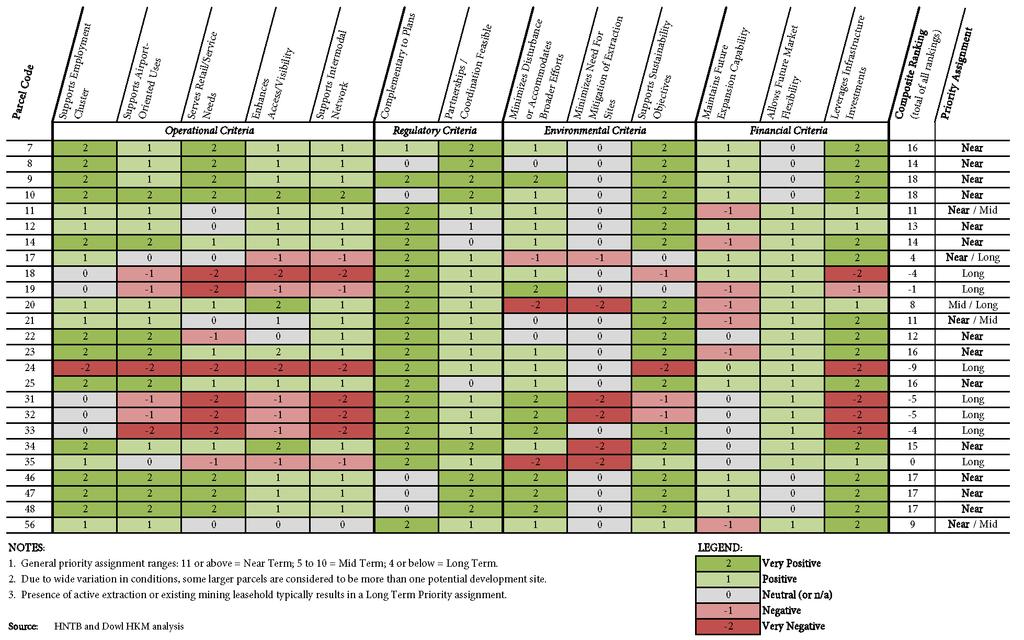
27 12TH NOGALES UNION PACIFIC RAILROAD PARK TUCSON ALVERNON SWAN WILMOT CAMPBELL KOLB DREXEL COUNTRY CLUB VALENCIA LITTLETOWN 8 CRAYCROFT LEGEND 19 SAN XAVIER LOS REALES # RESERVE LAND AREA (APPROXIMATE) PRIMARY (AERONAUTICAL) LAND TIA AIRFIELD TIA PARCEL NUMBER NEAR TERM POTENTIAL 56 MID TERM POTENTIAL 17 LONG TERM POTENTIAL HUGHES ACCESS OLD VAIL CONNECTION Master Plan Update TUCSON INTERNATIONAL AIRPORT DRAWING SCALE: 1 = 4,000 DATE: February, 2013 DEVELOPMENT POTENTIAL FIGURE 7-7
28
29
30


31
32
33
34
 FUTURE HIGH SPEED RAIL (HSR) 19 LOS REALES 10 LOCAL TRANSIT STATION HIGH SPEED RAIL STATION SAN XAVIER COMMERCIAL NODE SPECIAL PLANNING AREA")
35 12TH NOGALES PARK TUCSON ALVERNON SWAN WILMOT CAMPBELL KOLB DREXEL COUNTRY CLUB LEGEND EXISTING ROAD NETWORK VALENCIA LITTLETOWN CRAYCROFT PROGRAMMED ROAD (APPROXIMATE) EXISTING UNION PACIFIC RAILROAD FUTURE LOCAL TRANSIT CIRCULATOR (APPROXIMATE) FUTURE HIGH SPEED RAIL (HSR) 19 LOS REALES 10 LOCAL TRANSIT STATION HIGH SPEED RAIL STATION SAN XAVIER COMMERCIAL NODE SPECIAL PLANNING AREA AIRPORT PROPERTY BOUNDARY EXTENDED CLEAR ZONE POLICY AREA UNION PACIFIC RAILROAD AIRFIELD EMPLOYMENT (OFFICE / INDUSTRIAL) INDUSTRIAL / LOGISTICS HUGHES ACCESS (NO PUBLIC ACCESS) LARGE SCALE INDUSTRIAL NATURAL CORRIDOR / MITIGATION GENERAL AVIATION MIXED USE AVIATION AIRPORT LANDSIDE OLD VAIL CONNECTION CARGO TERMINAL AIR NATIONAL GUARD AIRPORT SUPPORT AVIATION INDUSTRIAL LARGE SCALE SOLAR SCALE Master Plan Update TUCSON INTERNATIONAL AIRPORT DRAWING SCALE: 1 = 4,000 DATE: February, 2013 FUTURE DEVELOPMENT PLAN FIGURE 7-8
36
37
38
39 o o o o
40
Phoenix Habitat Restoration Projects
 Phoenix Habitat Restoration Projects Spur Cross Ranch Cave Creek (Estergard) Regional Tree and Shade Summit March 9, 2010 Desert Riparian Ecosystems Healthy riparian areas like this once existed along
COMMERCIAL/RETAIL PAD(S) AVAILABLE
 AVAILABLE") COMMERCIAL/RETAIL PAD(S) AVAILABLE EXCLUSIVE LISTING SWC 22ND STREET & HOUGHTON ROAD TUCSON, ARIZONA Case Park OVERVIEW Excellent commercial corner opportunity Across from planned Fry s Marketplace One
COMMERCIAL/RETAIL PAD(S) AVAILABLE EXCLUSIVE LISTING SWC 22ND STREET & HOUGHTON ROAD TUCSON, ARIZONA Case Park OVERVIEW Excellent commercial corner opportunity Across from planned Fry s Marketplace One
FEASIBILITY STUDY. holdings SEPTEMBER 13, prepared for: prepared by:
 FEASIBILITY STUDY SEPTEMBER 13, 2013 prepared for: holdings prepared by: Table of Contents Project Feasibility... 3 Project Background... 4 Project and Community Context... 5 Site constraints... 6 Statement
TRINITY RIVER CORRIDOR
 TRINITY RIVER CORRIDOR MODIFIED DALLAS FLOODWAY PROJECT UPDATE May 12, 2015 Jon Loxley Project Manager Dallas Floodway Project Fort Worth District U.S. Army Corps of Engineers US Army Corps of Engineers
Preliminary Site Evaluation
 Preliminary Site Evaluation 100 Acre Site, US 72 Piperton, Tennessee Power Distributor: Chickasaw Electric Cooperative August 2010 SITE DATA SHEET PIPERTON US 72 SITE (100 ACRES): LOCATION & GENERAL DESCRIPTION
RINCON KNOLLS P&E LOTS
 Wilmot olb Pantano Harrison RINCON NOLL - 189 P&E LOT EXCLUIVE LITING VAIL UBMARET TUCON, ARIZONA Leon E Monthan pider Rock tunning views of the Rincon Valley and Rincon s Extremely limited supply of entitled
Carson City Open Space APNs and , west of Deer Run Road bridge
 32 acres (See separate packet for information on this open space property) OPEN SPACE PROPERTY APNs 008-541-73 and 008-541-92 (north and south sides of the river) Morgan Mill Road River Access Area (parking
Flood History. Floodplain Descriptions
 Flood History The worst flooding in the area took place in 1966, 1969, 1971, 1995 and 1998. The storms in 1966 and 1969 caused considerable damage throughout the area due to flooding, erosion and debris
APPLICANTS PROPOSED TOUR SCHEDULE & PROTOCOL
 APPLICANTS PROPOSED TOUR SCHEDULE & PROTOCOL Pursuant to Paragraph 18 of the Procedural Order issued by the Chairman of the Power Plant and Transmission Line Siting Committee (the Committee ) on August
Stakeholder Group Information Packets
 Exhibit J-1. Stakeholder Group Information Packets J-13 CEC Application THIS PAGE INTENTIONALLY LEFT BLANK J-14 CEC Application Rosemont 138-kV Transmission Line Project Stakeholder Group Handbook J-15
Rockin River Ranch State Park
 Rockin River Ranch State Park Public Meeting No. 3 August 16 th, 2017 Arizona State Parks and Trails (ASPT) Welcome Executive Director Sue Black Park budget = $4 million Balance of recreation uses, environment,
Gerald R. Ford International Airport Authority Master Plan Update A World Class Gateway
 Gerald R. Ford International Airport Authority Master Plan Update A World Class Gateway Master Plan Advisory Committee (MPAC) Alternatives September 28, 2017 AGENDA Review of Previous Work Ultimate Land
PULLMAN-MOSCOW REGIONAL AIRPORT Runway Realignment Project
 PULLMAN-MOSCOW REGIONAL AIRPORT Runway Realignment Project GENERAL AIRPORT INFORMATION AIRPORT USERS Airport ownership: Public, owned by the Pullman-Moscow Regional Airport Board Year opened: February
Airport Planning Area
 PLANNING AREA POLICIES l AIRPORT Airport Planning Area LOCATION AND CONTEXT The Airport Planning Area ( Airport area ) is a key part of Boise s economy and transportation network; it features a multi-purpose
SOUTH INTERCHANGE AREA
 Santaquin City General Plan 1 Location and Characteristics The South Interchange Area of Santaquin is located west of Interstate 15 and south of 500 South (Figure 1). It includes properties already annexed
WESTERN CROSSING ONE & TWO
 Pinal way Ave Diversion Dam Rd WESTERN CROSSING ONE & TWO W/NWC MAIN STREET & HWY 287 FLORENCE, PINAL COUNTY, ARIZONA Ave LOCATION Property is located west of the northwest corner of reet & Highway 287
PFC Quarterly Status Report September 30, 2016
 PFC Quarterly Status Report September 0, 06 Public Agency: Greater Orlando Aviation Authority Use Airport: Orlando International Airport (MCO) Charge Expiration Date: $4.50 8//08 Total Collection Authority
Chapter 2: Entire US287 Corridor
 Chapter 2: Entire US287 Corridor The US287 Study Area spans four incorporated jurisdictions and two counties. Due to the length and density of infrastructure along the US287 Study Area, corridor-wide maps
Welcome Land Use Element... LU-1
 Welcome Land Use Element... LU-1 Land Use Plan... LU-3 Residential Land Uses... LU-12 Commercial Land Uses... LU-14 Mixed Use... LU-16 Industrial Land Uses... LU-18 Automobile-Related Land Uses... LU-19
CHAPTER 2 ALTERNATIVES
 CHAPTER 2 ALTERNATIVES 2.1 ALTERNATIVES INTRODUCTION An Environmental Impact Statement (EIS) describes and discusses the significant environmental impacts that would be caused by the Proposed Action, its
Master Plan Update Community Advisory Committee Kick-off Meeting
 Nashville International Airport Master Plan Update Community Advisory Committee Kick-off Meeting September 13, 2018 Agenda Welcome and Introductions Master Plan Objectives Master Plan Process BNA Vision
Comments On Proposed Future Bond Projects PR153 TORTOLITA MOUNTAIN PARK FM103 PR185 RD HP110 RD RD MOORE MARANA TANGERINE ña Ca SHANNON CAMINO RD RD O
 Comments On Proposed Future Bond Projects PR153 TORTOLITA MOUNTAIN PARK FM103 PR185 HP110 MOORE MARANA TANGERINE ña Ca SHANNON CAMINO O HAY M AG CO RT AR O INA EE PR103 - Rillito Racetrack - Conversion
KNIGHTS LANDING RIVER RANCH WOODLAND, CA - YOLO COUNTY
 PROPERTY HIGHLIGHTS ±77.2 Gross Acres Contains Excellent Sandy and Silty Clay Loam Soils Established Surface Water Rights in Sacramento River Developed River Diversion and Distribution System Three Phase
F RIENDS OF THE SONORAN DESERT Open Space Bond Newsletter
 F RIENDS OF THE SONORAN DESERT Open Space Bond Newsletter Volume 1, Issue 2 Sponsoring Organizations Arizona Open Land Trust Arizona-Sonora Desert Museum Coalition for Sonoran Desert Protection Sonoran
Appendix. Gatwick Airport Ltd - Further information on Gatwick s revised phasing strategy (including Programme) Gatwick Airport Limited
 Gatwick Airport Limited") Gatwick Airport Limited Response to Airports Commission Consultation Appendix 37 Gatwick Airport Ltd - Further information on Gatwick s revised phasing strategy (including Programme) Further information
Gatwick Airport Limited Response to Airports Commission Consultation Appendix 37 Gatwick Airport Ltd - Further information on Gatwick s revised phasing strategy (including Programme) Further information
Airport Master Plan. Brookings Regional Airport. Runway Runway 17-35
 Runway 17-35 Airport Master Plan Runway 12-30 Brookings Regional Airport Table of Contents Table of Contents Chapter 1: Master Plan Goals... 1-1 1.1. Introduction... 1 1.2. Objective 1 Identify improvements
Atlantic Surveying, P.A. Professional Land Surveyors
 A S Atlantic Surveying, P.A. Professional Land Surveyors 111 S. Queen Street Kinston, N.C. 28501 (252) 527-6994 Fax: (252) 522-0139 Email: wcbutler@embarqmail.com fwdavenport@embarqmail.com Established
2.0 Physical Characteristics
 _ 2.0 Physical Characteristics 2.1 Existing Land Use for the Project The site is comprised of approximately 114 acres bounded by Highway 101 to the north, the existing town of Los Alamos to the east, State
Town of Oakfield Agricultural and Farmland Protection Plan
 SECTION III COMMUNITY OVERVIEW A. Regional Setting / Location The Town of Oakfield is located in the northwestern portion of Genesee County. Located west of New York's Finger Lakes, the Town is uniquely
A VISION FOR EL MIRAGE
 el mirage A VISION FOR EL MIRAGE OASIS, ARIZONA A thriving desert jewel destination with a strong arts district, high-wage employment parks system joined together by cohesive, multi-use accessible trails
 Existing Conditions AIRPORT PROFILE Passenger Terminal Complex 57 air carrier gates 11,500 structured parking stalls Airfield Operations Area 9,000 North Runway 9L-27R 6,905 Crosswind Runway 13-31 5,276
UAV Flight Services Company. What We Do. What Sets us Apart
 UAV Flight Services Company A dedicated team of aviators, technologists, and engineers. What We Do UAV flight services for data collection, mapping, and inspection What Sets us Apart Extensive field experience,
Connecting Nevada Partners The Connecting Nevada Stakeholders that participated in this effort are listed below in alphabetical order.
 Acknowledgements The Connecting Nevada project would not have been possible without the guidance and input of a number of stakeholders who demonstrate a commitment to making Nevada s transportation system
APPENDIX F List of Commitments
 APPENDIX F List of Commitments s Table F.1 Standard Mitigation Measures Mitigation Measure MnDOT Specification Number Status Update Description Status Update Utilities Provide early notice to utility operators
EPPERSON INDUSTRIAL PARK
 EXCLUSIVE LISTING FUTURE INDUSTRIAL SITE ±680 ACRES SALT LAKE CITY, UTAH 3300 N Subject 40.54 acres 3200 W 550.46 acres 40.17 acres 2100 N 40.09 acres Sold Future State Prison Site ± 325 Acres Haul Road
Parkland County Municipal Development Plan Amendment Acheson Industrial Area Structure Plan
 Parkland County Municipal Development Plan Amendment Acheson Industrial Area Structure Plan New Plan Acheson Industrial Area Structure Plan Amendment Parkland County Municipal Development Plan Board Reference
CATARACT CREEK ESTATES
 CATARACT CREEK ESTATES EXCLUSIVE LISTING WILLIAMS, ARIZONA LOCATION NWC of Airport Road and Lake Ellen Way, Williams, Arizona SIZE ±38.95 acres LOT DESCRIPTION 55 P&E Single Family Lots (7,000 sq. ft.)
Public Workshop #7 Land Use Planning June 28, 2016
 Public Workshop #7 Land Use Planning June 28, 2016 Land Use Planning and Vision 2040 What is Land Use Planning in the context of the Vision 2040 process? Vision 2040 Aeronautical Development Land Use Compatibility
APPENDIX OFFICIAL MAP ORDINANCE OF HAMILTONBAN TOWNSHIP OFFICIAL MAP NARRATIVE
 APPENDIX A OFFICIAL MAP ORDINANCE OF HAMILTONBAN TOWNSHIP OFFICIAL MAP NARRATIVE INTRODUCTION: The Official Map of Hamiltonban Township has been prepared to identify those lands and features that Hamiltonban
Classifications, Inventory and Level of Service
 Classifications, Inventory and Level of Service Section 3 Kenmore Park, Recreation and Open Space Plan 1 P a g e Classifications and Inventory Park Classifications Kenmore classifies its parks based upon
Addendum - Airport Development Alternatives (Chapter 6)
") Bowers Field Addendum - Airport Development Alternatives (Chapter 6) This addendum to the Airport Development Alternatives chapter includes the preferred airside development alternative and the preliminary
Bowers Field Addendum - Airport Development Alternatives (Chapter 6) This addendum to the Airport Development Alternatives chapter includes the preferred airside development alternative and the preliminary
South Westminster and Bridgeview
 City of Surrey SURREY South Westminster and Bridgeview Industrial Areas WASHINGTON STATE, USA Located on the south shore of the Fraser River, the Bridgeview (307.14 acres/124.295 hec) and South Westminster
DRAFT GENERAL IMPLEMENTATION PLAN AND SPECIFIC IMPLEMENTATION PLAN MIDDLETON MUNICIPAL AIRPORT MOREY FIELD. Revised 12/12/03
 DRAFT GENERAL IMPLEMENTATION PLAN AND SPECIFIC IMPLEMENTATION PLAN MIDDLETON MUNICIPAL AIRPORT MOREY FIELD Revised 12/12/03 As recommended for approval by the Plan Commission General Project Description
Draft Concept Alternatives Analysis for the Inaugural Airport Program September 2005
 Section 10 Preferred Inaugural Airport Concept 10.0 Introduction The Preferred Inaugural Airport Concept for SSA was developed by adding the preferred support/ancillary facilities selected in Section 9
AIRPORT DEVELOPMENT PLAN. Design-Build Institute of America September 8, 2015
 AIRPORT DEVELOPMENT PLAN Design-Build Institute of America September 8, 2015 Lindbergh Field - 1935 3 Page 2 Lindbergh Field - 1944 3 Page 3 Lindbergh Field - 1955 3 Page 4 San Diego International Airport
I-3 DFW Extension Public Hearing. June 2, 2011
 1 I-3 DFW Extension Public Hearing June 2, 2011 2 DFW LRT Extension Agenda: Introductions Service Plan Amendment Alignment, Grade Separations, Station, Yard Environmental Assessment Environmental Impacts/Mitigation
Table of Contents. Master Plan March 2014 TOC i Spokane International Airport
 Table of Contents Page Chapter 1 Inventory 1. Introduction... 1 1 1.1 Community Profile... 1 2 1.1.1 Location and Setting... 1 1 1.1.2 Climate... 1 2 1.1.3 Socioeconomic Conditions... 1 5 1.1.4 Area Land
Chapter 5 Airport Development Alternatives
 Chapter 5 Airport Development Alternatives Introduction CHAPTER 5 AIRPORT DEVELOPMENT ALTERNATIVES JUNE 2013-1 Evaluation Process No-Action Alternative CHAPTER 5 AIRPORT DEVELOPMENT ALTERNATIVES JUNE 2013-2
RESOLUTION R WHEREAS, the required publications and public hearing have been conducted by the Planning Commission and the Town Council; and
 RESOLUTION R2000-02 A RESOLUTION OF THE MAYOR AND TOWN COUNCIL OF THE TOWN OF CAVE CREEK, ARIZONA AMENDING THE GENERAL PLAN IN ACCORDANCE WITH REVISED STATUTES WHEREAS, the Open Space Element was transmitted
Goals and Policies Report
 Tulare County General Plan 2030 Update Table of Contents Part I Goals and Policies Report Chapter 1 Introduction 1-1 Section 1.1 General Plans in California 1-1 Section 1.2 Tulare County General Plan:
The City s Strategic Economic Support Projects
 INTEGRATED FOOD TERMINAL The Integrated Food Terminal is envisioned as a strategic location of wholesale agricultural produce marketing facility with separate hog and cattle/goat/sheep abattoirs and a
Final Drainage Letter Pikes Peak Community College Downtown Parking Lot Colorado Springs, Colorado
 Final Drainage Letter Pikes Peak Community College Downtown Parking Lot Colorado Springs, Colorado Prepared for: Pikes Peak Community College 5775 South Academy Boulevard Colorado Springs, CO 80906-5422
Daisy Dean Trail 628/619 ATV Trail Construction
 Background and Purpose and Need The Daisy Dean ATV Trail Construction Project is located in the Little Belt Mountains, Musselshell Ranger District, Lewis and Clark National Forest approximately 32 miles
AIRPORT MASTER PLAN UPDATE
 AIRPORT MASTER PLAN UPDATE PENSACOLA INTERNATIONAL AIRPORT Technical Advisory Committee Meeting #2 June 20, 2017 Agenda» Introduction» Facility Requirements Airside Terminal Landside General Aviation Cargo
LAX Specific Plan Amendment Study (SPAS) Update. December 3, 2012
 Update. December 3, 2012") LAX Specific Plan Amendment Study (SPAS) Update December 3, 2012 Response to the Draft Environmental Impact Report Draft EIR Release and Public Comment Official Comment Period was July 27, 2012 through
LAX Specific Plan Amendment Study (SPAS) Update December 3, 2012 Response to the Draft Environmental Impact Report Draft EIR Release and Public Comment Official Comment Period was July 27, 2012 through
CLASS SPECIFICATION 5/12/11 SENIOR AIRPORT ENGINEER, CODE 7257
 Form PDES 8 THE CITY OF LOS ANGELES CIVIL SERVICE COMMISSION CLASS SPECIFICATION 5/12/11 SENIOR AIRPORT ENGINEER, CODE 7257 Summary of Duties: A Senior Airport Engineer performs the more difficult and
ROUTE ANALYSIS PROCESS
 ROUTE ANALYSIS PROCESS Progress to Date: 1. Recorded and labeled all routes received from PAT Meetings. 2. Determined opportunity, avoidance and exclusion areas crossed by PAT proposed routes. 3. Routes
Birmingham Airport 2033
 Over the next 15 years, we will expand and improve the Airport to maximise our potential as a single runway airport by investing 500 million in new development. Our plans take account of our forecasted
LAX Plan September 29, 2004
 LAX Plan September 29, 2004 LAX Plan Table of Contents 1. PURPOSE OF THE PLAN.....1 1.1 Use of the Plan. 1 1.2 Vision.....1 1.3 The LAX Plan Area.. 2 2. GOALS AND OBJECTIVES......2 3. POLICIES AND PROGRAMS
What is an Airport Master Plan?
 What is an Airport Master Plan? The goal of a master plan is to provide the framework needed to guide future airport development that will cost-effectively satisfy aviation demand, while considering potential
Table of Contents. List of Tables. Cincinnati/Northern Kentucky International Airport 2035 Master Plan Update
 Table of Contents 7.1. Airport Layout Plan (Existing Conditions)... 2 7.2. Airport Layout Plan (Future Conditions)... 3 7.3. Technical Data Sheet... 5 7.4. Commercial Terminal Area Drawing... 5 7.5. East
Case Study: 1. The Clarence River Catchment
 Case Study: 1. The Clarence River Catchment The NSW coastline is a great natural asset, making an enormous contribution to the economy. The resources of coastal catchments such as the Clarence River Catchment,
FLL Master Plan Update Technical Advisory Committee (TAC) Briefing #1. September 28, 2016
 Briefing #1. September 28, 2016") FLL Master Plan Update Technical Advisory Committee (TAC) Briefing #1 September 28, 2016 TAC Committee Role: Internal Stakeholders To provide input on the master planning analysis from the technical and
FLL Master Plan Update Technical Advisory Committee (TAC) Briefing #1 September 28, 2016 TAC Committee Role: Internal Stakeholders To provide input on the master planning analysis from the technical and
2. Project Description and Alternatives
 2. Project Description and Alternatives 2.1 Introduction Traffic on U.S. 93 in Boulder City doubled from 17,200 average daily traffic (ADT) in 1985 to approximately 32,000 ADT in 1999. This increase in
LAX Specific Plan Amendment Study (SPAS) Final EIR and Related Actions. Board of Airport Commissioners February 5, 2013
 Final EIR and Related Actions. Board of Airport Commissioners February 5, 2013") LAX Specific Plan Amendment Study (SPAS) Final EIR and Related Actions Board of Airport Commissioners February 5, 2013 1 Background The LAX Master Plan Program serves as the airport s long range development
LAX Specific Plan Amendment Study (SPAS) Final EIR and Related Actions Board of Airport Commissioners February 5, 2013 1 Background The LAX Master Plan Program serves as the airport s long range development
TGS CEDAR PORT INDUSTRIAL PARK
 Grand Pkwy ±10,000 ACRES AVAILABLE R Loop 201 R BNSF BAYER CHEMICAL UP & TGS INDUSTRIAL PARK FM 14 05 NRG BAYTOWN WATER RESERVOIR HOME DEPOT Fisher Rd PBP EXEL CEDAR PORT WAL-MART BORUSAN MANNESMANN Borusan
TOP CAPITAL PROGRAMS
 TOP CAPITAL PROGRAMS By Rebekah Morris Arizona Builder s Exchange, LLC rmorris@azbex.com Grateful to not be in California My hometown faces a $70M statedictated pension contribution LOMPOC, CA Drastically
2016 Regional Transportation Alternatives Program (TAP) Grant Application
 Grant Application") 2016 Regional Transportation Alternatives Program (TAP) Grant Application PROJECT TITLE: Yelm-Tenino Trail Extension Feasibility Study TRPC use only GENERAL PROJECT INFORMATION Agency or Organization City
2016 Regional Transportation Alternatives Program (TAP) Grant Application PROJECT TITLE: Yelm-Tenino Trail Extension Feasibility Study TRPC use only GENERAL PROJECT INFORMATION Agency or Organization City
REAL ESTATE PLAN ADOLFO SUÁREZ MADRID-BARAJAS AIRPORT
 REAL ESTATE PLAN ADOLFO SUÁREZ MADRID-BARAJAS AIRPORT Adolfo Suárez Madrid-Barajas Airport A landmark airport 53.4 million Passengers +5.9% 387 thousand Operations +2.5% Gateway to Latin America 27 destinations
FAQ ANSWERS. Allow a minimum of 3-4 hours to visit all five hangars and 80 acres of exhibits. See the PLAN YOUR VISIT for more details.
 FAQ ANSWERS WHAT SHOULD I WEAR? First of all, comfortable walking shoes. Please also dress in layers for the forecasted weather as 50% of our extensive collection is located out of doors. Tucson is known
REAL ESTATE PLAN ADOLFO SUÁREZ MADRID-BARAJAS AIRPORT
 REAL ESTATE PLAN ADOLFO SUÁREZ MADRID-BARAJAS AIRPORT Adolfo Suárez Madrid-Barajas Airport A landmark airport 53.4 million Passengers +5.9% 387 thousand Operations +2.5% Gateway to Latin America 27 destinations
Miami Orlando Passenger Rail Project Overview
 Miami Orlando Passenger Rail Project Overview 1 The Historical Significance of Florida East Coast Industries Henry Flagler transformed Florida when he built his railroad FEC Railway connected cities along
THOMAS A. SWIFT METROPARK Introductions History Present Conditions Future Development Plans Implementation Strategies Statistics
 THOMAS A. SWIFT METROPARK Introductions History Present Conditions Future Development Plans Implementation Strategies Statistics Introduction As an open meadow park positioned along the Mahoning River,
The Atlanta BeltLine. & Sustainable Development GAFM Conferance. // March 25, 2014
 The Atlanta BeltLine & Sustainable Development GAFM Conferance // March 25, 2014 04/22/2014 Atlanta BeltLine // 2013 Page 1 // Organizational Structure Project Owner and Sponsor Redevelopment Authority
N VANCOUVER AVE PARCEL
 FOR SALE N. VANCOUVER COMMERCIAL OPPORTUNITY - in - PORTLAND OREGON LILLIS ALBINA CITY PARK LEGACY EMANUEL MEDICAL CENTER LOCATED on N. Vancouver Ave 2839 SW 2nd Avenue Portland OR, 97201 503.222.1655
Chapter 4.0 Alternatives Analysis
 Chapter 4.0 Alternatives Analysis Chapter 1 accumulated the baseline of existing airport data, Chapter 2 presented the outlook for the future in terms of operational activity, Chapter 3 defined the facilities
Lake Tahoe Airport Master Plan Public Meeting March 16, 2015
 Lake Tahoe Airport Master Plan Public Meeting March 16, 2015 What is an Airport Master Plan? a comprehensive study of an airport [that] usually describes the short, medium, and long term development plans
Table 1: Iron Mountain Communication Site. Latitude 1 Longitude 1 Elev 2 Address T/R/S 3 APN 4 USGS Quadrangle
 County of Riverside Public Safety Enterprise Communication Project Appendix A: Candidate Site Descriptions Overview The site is located in San Bernardino County near several communication towers in the
CHAPTER 4: ALTERNATIVES
 MSP Long Term Comprehensive Plan Update Metropolitan Airports Commission 4.1 INTRODUCTION CHAPTER 4: ALTERNATIVES Several alternatives were developed and evaluated based on their capability to meet the
The Island. Johnson Ave. Grand St. Fair St. Knower Ave. Main St. Brookside Pl. Furman Dr ,000 2,000 Feet
 front Recreational Assets Planning Fox reek bury Rd Schoharie reek 0 50 Feet front Revitalization Area (WRA) Boundary State Route ounty/town/village Road Village of Schoharie front Recreational Assets
Decision Memo for Desolation Trail: Mill D to Desolation Lake Trail Relocation
 for Salt Lake County, Utah Uinta-Wasatch-Cache National Forest Salt Lake Ranger District 1. Background The present location of the Desolation Trail (#1159) between Mill D and Desolation Lake follows old
MONTEREY REGIONAL AIRPORT MASTER PLAN TOPICAL QUESTIONS FROM THE PLANNING ADVISORY COMMITTEE AND TOPICAL RESPONSES
 MONTEREY REGIONAL AIRPORT MASTER PLAN TOPICAL QUESTIONS FROM THE PLANNING ADVISORY COMMITTEE AND TOPICAL RESPONSES Recurring topics emerged in some of the comments and questions raised by members of the
Subject Property Schuster St Las Vegas, NV SW Las Vegas Ind. LOCATION Distance to Seaport:
 Subject Property 6615 Schuster St Las Vegas, NV 89118 - SW Las Vegas Ind LOCATION Distance to Airport: 6.2 mi Distance to Seaport: 232.5 mi Distance to Rail Terminal: 6.7 mi Population 500 Mile Radius:
Facilities Implementation Plan
 Airport Master Plan Facilities Implementation Plan Prepared by: AECOM Prepared for: Illinois Department of Transportation May 20, 2013 Table of Contents Topic Page Number Cover Sheet... Cover Sheet Table
Official Plan Amendment No 76 Airport and Employment Hearing 2011 P a g e 1
 Official Plan Amendment No 76 Airport and Employment Hearing 2011 P a g e 1 8(f) 2.2.3 Managing Growth Within the Urban Area Employment 19. In all urban communities outside the Central Area, opportunities
EXECUTIVE SUMMARY FORT LAUDERDALE-HOLLYWOOD INTERNATIONAL AIRPORT (FLL) MASTER PLAN UPDATE PHASE 1
 MASTER PLAN UPDATE PHASE 1") Workshop Briefing Package Airport Master Plan Update, Phase I Fort Lauderdale-Hollywood International Airport October 18, 2005 Leigh Fisher Associates A Division of Jacobs Consultancy Inc. EXECUTIVE SUMMARY
Workshop Briefing Package Airport Master Plan Update, Phase I Fort Lauderdale-Hollywood International Airport October 18, 2005 Leigh Fisher Associates A Division of Jacobs Consultancy Inc. EXECUTIVE SUMMARY
Request for Scoping Comments Regarding Environmental Issues of Concern
 March 16, 2009 Request for Scoping Comments Regarding Environmental Issues of Concern Environmental Assessment for Proposed Airport Land Lease and Airport Construction Pahrump Valley General Aviation Airport,
Weymouth & Hingham (ARAWH) Draft Report: Weymouth Water Supply & Regulatory Review
 Draft Report: Weymouth Water Supply & Regulatory Review") Advocates of Rockland, Abington, Weymouth & Hingham (ARAWH) Draft Report: Weymouth Water Supply & Regulatory Review Technical Assistance Services for Communities 2010 Thursday, November 4, 7:00 8:45 p.m.
Advocates of Rockland, Abington, Weymouth & Hingham (ARAWH) Draft Report: Weymouth Water Supply & Regulatory Review Technical Assistance Services for Communities 2010 Thursday, November 4, 7:00 8:45 p.m.
Nantucket Memorial Airport Commission. Master Plan Workshop. October 26, 2012
 Nantucket Memorial Airport Commission Master Plan Workshop October 26, 2012 Agenda Introductions Master Plan 101 Airport Planning Issues Noise Abatement Activities Environmental Monitoring Public Outreach
MAPLEWOOD VILLAGE CENTRE AND INNOVATION DISTRICT IMPLEMENTATION PLAN & DESIGN GUIDELINES. November 6, 2017 Regular Meeting of Council
 MAPLEWOOD VILLAGE CENTRE AND INNOVATION DISTRICT IMPLEMENTATION PLAN & DESIGN GUIDELINES November 6, 2017 Regular Meeting of Council Recommendation THAT Council: Approve the Maplewood Village Centre and
ERIE INTERNATIONAL AIRPORT MASTER PLAN TABLE OF CONTENTS
 EXECUTIVE SUMMARY ERIE INTERNATIONAL AIRPORT MASTER PLAN TABLE OF CONTENTS PAGE NO. CHAPTER 1-INTRODUCTION... 1-1 1.01 General...1-1 1.02 Purpose and Scope of Study...1-1 1.03 The Planning Process...1-2
"ST. KLIMENT OHRIDSKI FACULTY OF GEOLOGY AND GEOGRAPHY
 SOFIA UNIVERSITY "ST. KLIMENT OHRIDSKI FACULTY OF GEOLOGY AND GEOGRAPHY APPLICATION OF THE MODEL "DRIVING FORCES PRESSURE STATE - RESPONSE FOR ASSESSMENT OF FLOOD RISK RADOSTINA BORISOVA DOCHEVA Bachelor
1 DOCKET NO. L-OOOOOYY
 ~ 3 4 I 1 2 4 5 6 7 8 9 1 11 12 13 14 15 16 17 18 19 2 21 22 23 24 25 26 27 28 AND TRANSMISSION LINE SITING [N THE MATTER OF THE APPLICATION 3F SUNZIA TRANSMISSION LLC, IN ZONFORMANCE WITH THE REQUIREMENTS
Land Use Policy Considerations
 Land Use Policy Considerations Challenges to Implementing Successful Land Use Strategies at Airports ACRP Insight Event: Washington DC Stephen D. Van Beek, Ph.D. April 11, 2018 Land Use Policy Considerations
White Mountain National Forest Saco Ranger District
 United States Department of Agriculture Forest Service White Mountain National Forest 33 Kancamagus Highway Conway, NH 03818 Comm: (603) 447-5448 TTY: (603) 447-3121 File Code: 1950 Date: February 26,
Lecture 08, 22 Sep 2003 Role Playing. Conservation Biology ECOL 406R/506R University of Arizona Fall Kevin Bonine
 Lecture 08, 22 Sep 2003 Role Playing Conservation Biology ECOL 406R/506R University of Arizona Fall 2003 Kevin Bonine 1. Role Playing Exercise 2. Exam Wed -group portion outside - ~40 minutes individual,
Bellevue South Park. Located between E 26th and E 28th at Mt. Carmel Place, in the Borough of Manhattan.
 Bellevue South Park Located between E 26th and E 28th at Mt. Carmel Place, in the Borough of Manhattan. Community Board 6 Review January 2, 2018 Christopher M. Crowley, RLA NYC Parks Total Budget: Project
SouthwestFloridaInternational Airport
 SouthwestFloridaInternational Airport SouthwestFloridaInternationalAirportislocatedinLee CountyalongtheGulfCoastofSouthFlorida,tenmiles southeastofthefortmyerscentralbusinessdistrict. Theprimaryhighwayaccesstotheairportfrom
CHAPTER 1: INTRODUCTION
 CHAPTER 1: INTRODUCTION Purpose and Scope The information presented in this report represents the study findings for the 2016 Ronan Airport Master Plan prepared for the City of Ronan and Lake County, the
Meeting Presentation. Sacramento International Airport Master Plan Update October 30, 2012
 Meeting Presentation Master Plan Update October 30, 2012 Agenda We encourage open discussion during today s meeting Team Goals Background (Airport Master Plans) Areas of Emphasis Schedule Special Concerns