TRINITY RIVER CORRIDOR
|
|
|
- Opal MargaretMargaret McCoy
- 5 years ago
- Views:
Transcription

1 TRINITY RIVER CORRIDOR MODIFIED DALLAS FLOODWAY PROJECT UPDATE May 12, 2015 Jon Loxley Project Manager Dallas Floodway Project Fort Worth District U.S. Army Corps of Engineers US Army Corps of Engineers 1
2 2
3 3
4 Dallas Floodway Project Milestone: April 21, 2015 Jo-Ellen Darcy, Assistant Secretary of the Army (Civil Works), signs the Record of Decision Two documents approved Final Environmental Impact Statement Final Feasibility Report Conclusion Dallas Floodway Project could proceed 4


5 Tonight s Trinity Talk Trinity River in Dallas through the years Approved Modified Dallas Floodway Project USACE Next Steps for the Modified Dallas Floodway Project Dallas Floodway, Dallas, Texas 5

6 Government Partners Complex project with many participants, many responsibilities and one shared goal - LIFE SAFETY IS PRIORITY NO. 1. Corps of Engineers City of Dallas / NF Sponsor Dallas County North Texas Tollway Authority Texas Dept. of Transportation Fed. Highway Administration EPA FEMA Texas Commission on Environmental Quality North Central Texas Council of Governments 6

7 Upper Trinity River Watershed 7


8 Historic Context: Trinity River, Dallas, Texas Planned Port of Dallas, 1892 Trinity Snag Boat, 1892 Trinity Flood,


9 Historic Context: Dallas Floodway and Reclamation Project, Nov 1929 Old Confluence New Confluence 9


10 Historic Context: Original Construction Dallas Floodway, 30 October 1930 New Confluence Trinity River Flood Stage, 12 June

11 Historic Context: USACE Strengthening in 1950s - Today Dallas Floodway - Current West Levee East Levee Downtown Dallas Residential Areas Trinity River Flooding,
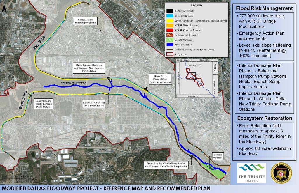
12 Trinity River Flooding History Existing Levee Elevation The existing Dallas Floodway can safely convey 0.067% AEP flood event (1,500-year event) Elevation % AEP (100-year event) Ground Elevation about May 1990 Elevation % AEP (37-year event) June 2007 Elevation % AEP (5-year event) Approximate low flow elevation within the river channel Elevation (400 cfs) 12

13 Current Dallas Floodway Project Legend Levee Pump Station 13


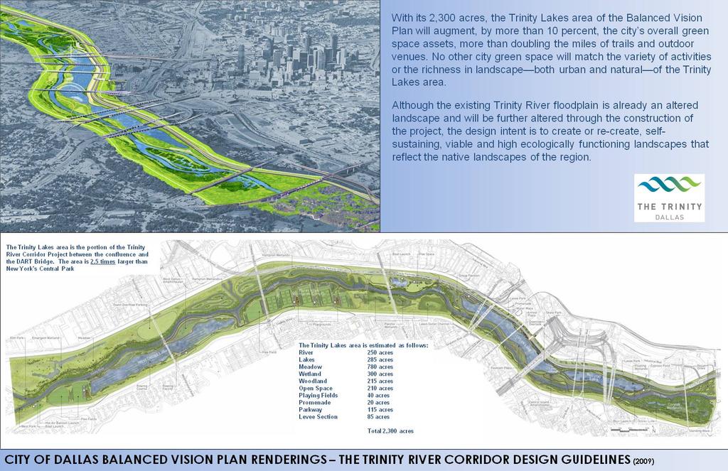
14 City of Dallas - Balanced Vision Plan Source: 2003 Balanced Vision Plan 14
15 Dallas Floodway Project What did the Corps of Engineers do? Performed extensive study of existing levee system and natural environment. Examined the impact of all projects anticipated between the levees in Dallas including those not part of the Modified Dallas Floodway Project. Developed solutions that reduce flooding risks and improve the quality of aquatic habitat 15


16 Modified Dallas Floodway Project Flood Risk and Ecosystem Restoration Problems FRM 200,000 people at Risk, residential areas on the West side, commercial areas on the East $13.7 Billion investment behind the levees ER River habitats been degraded over time due to relocation of the river channel within the Dallas Floodway 16

17 Modified Dallas Floodway Project Flood Risk and Ecosystem Restoration Project Objectives Balanced Vision Plan 2003 FRM Ensure future reliability and integrity of the floodway system reduce residual flood risk; Review of the City of Dallas Interior Drainage Plan ER Restore to the extent possible the aquatic and riparian ecosystem of the Trinity River within the boundaries of the Dallas Floodway Project. 17

18 Modified Dallas Floodway Project Flood Risk and Ecosystem Restoration Project Criteria Balanced Vision Plan 2003 FRM ER Formulate levee improvements to have the maximum net economic benefits; Reduction of overall life safety risk; Reduction of damage structures within 100-year floodplain; Inclusion of select IDP features not already built; Provide uplift of habitat function following project completion. 18

 Flood Risk Management Interior Drainage Plan")

 Approx.")
19 Modified Dallas Floodway Project Approved Plan 277,000 cfs levee raise with AT&SF Bridge Modifications Emergency Action Plan improvements Levee side slope flattening to 4H:1V 100% local cost) Flood Risk Management Interior Drainage Plan Phase I features (Baker and Hampton Pump Stations) Interior Drainage Plan Phase II features (Charlie, Delta, New Trinity Portland) Ecosystem Restoration River Relocation (add meanders to 8-miles of the Trinity River in the Floodway) Approx. 80-acre wetland in Floodway 19

20 Modified Dallas Floodway Project - Approved Plan Total Cost - $571,592,000 FRM - $241,657,000 ER - $329,935,000 FED - $371,535,000 NON-FED - $ 200,057,000 20


21 Benefits of the Modified Dallas Floodway Project Reduces the risk of river flooding. Reduces flooding risks related to interior drainage Improves environmental sustainability Functions as a comprehensive system 21
 and Section 404 (Clean Water Act) permits.")
22 Next Steps Corps seeks federal funding - Congressional appropriation for first phase: levee raises, bridge modification. Permits - Major construction projects by others require Corps-issued Section 408 (Rivers and Harbors Act) and Section 404 (Clean Water Act) permits. Construction-level design review - The Corps has ongoing oversight responsibility for all projects in the floodway including review of design documents and monitoring construction. Trinity Lakes - The city has told the Corps this is a top priority. 22
 Temple, U. S.")
23 Q&A The Trinity is the future of Dallas, and we need to build irreversible momentum, to see this project through. - Major General Merdith W.B. (Bo) Temple, U. S. Army Corps of Engineers, May 4,
24 24
SAN ANTONIO RIVER IMPROVEMENTS PROJECT. August 6, 2008
 SAN ANTONIO RIVER IMPROVEMENTS PROJECT August 6, 2008 1 History of the SA River Improvements 1921 Flood Olmos Dam Complete in 1929 Downtown Flood Relief Projects in 1950 s Dams on the River Channel and
SAN ANTONIO RIVER IMPROVEMENTS PROJECT. April 27, 2009
 SAN ANTONIO RIVER IMPROVEMENTS PROJECT April 27, 2009 1 Project Limits 2 Project Partners City of San Antonio Provides project funding for project amenities (i.e.. Sidewalks, Landscaping, Lighting, etc.)
FEASIBILITY STUDY. holdings SEPTEMBER 13, prepared for: prepared by:
 FEASIBILITY STUDY SEPTEMBER 13, 2013 prepared for: holdings prepared by: Table of Contents Project Feasibility... 3 Project Background... 4 Project and Community Context... 5 Site constraints... 6 Statement
San Antonio Channel Improvement Project MISSION REACH ECOSYSTEM RESTORATION PROJECT. Welcome Assistant Secretary (CW) Jo-Ellen Darcy December 8, 2009
 Jo-Ellen Darcy December 8, 2009") San Antonio Channel Improvement Project MISSION REACH ECOSYSTEM RESTORATION PROJECT Welcome Assistant Secretary (CW) Jo-Ellen Darcy December 8, 2009 1 Presentation Overview Review history of San Antonio
San Antonio Channel Improvement Project MISSION REACH ECOSYSTEM RESTORATION PROJECT Welcome Assistant Secretary (CW) Jo-Ellen Darcy December 8, 2009 1 Presentation Overview Review history of San Antonio
Phoenix Habitat Restoration Projects
 Phoenix Habitat Restoration Projects Spur Cross Ranch Cave Creek (Estergard) Regional Tree and Shade Summit March 9, 2010 Desert Riparian Ecosystems Healthy riparian areas like this once existed along
2012 Texas Water Conservation Association Meeting
 2012 Texas Water Conservation Association Meeting BG Thomas Kula Southwestern Division Commander 15 June 2012 US Army Corps of Engineers AGENDA UNCLASSIFIED Overview of Southwestern Division Missions Texas
The Mississippi River Commission. History of the Management of the Mississippi River. US Army Corps of Engineers BUILDING STRONG
 The Mississippi River Commission History of the Management of the Mississippi River US Army Corps of Engineers US Army Corps of Engineers Presentation Outline Overview of Mississippi River History of Mississippi
THE LEVEES OF DALLAS COUNTY
 THE LEVEES OF DALLAS COUNTY Jessica Baker, EIT, CFM Walter Skipwith, P.E. Steve Parker, P.E., CFM TFMA 2008 Spring Conference League City, TX May 1, 2008 Introduction Map Modernization Program Certification
PLANNING CONSIDERATIONS
 12TH NOGALES PARK TUCSON ALVERNON SWAN WILMOT CAMPBELL DREXEL COUNTRY CLUB LEGEND RESERVE LAND AREA (APPROXIMATE) POTENTIAL FUTURE HSR TO AIRPORT TRANSIT CONNECTIONS VALENCIA PIMA COUNTY CITY OF TUCSON
HIGHWAY 17 WILDLIFE and REGIONAL TRAIL CROSSINGS
 HIGHWAY 17 WILDLIFE and REGIONAL TRAIL CROSSINGS Agenda and Meeting Format 7:00-7:15 Welcome 7:15-8:00 Presentation 8:00-8:30 Open House 8:30 Recap 9:00 Conclusion 2 Meeting Goals: Introduce the project
Mr. Jeff Keever Deputy Executive Director Virginia Port Authority May 2, 2012
 Management of Dredged Materials: Challenges and Opportunities Mr. Jeff Keever Deputy Executive Director Virginia Port Authority May 2, 2012 1 Craney Island Eastward Expansion and Marine Terminal NNMT Hampton
US 380 FEASIBILITY STUDY
 US 380 FEASIBILITY STUDY Denton County CSJ(s): 0135-10-061, 0135-10-062 Public Meeting(s): January 15 & 22, 2019 WELCOME US 380 Denton County Feasibility Study DALLAS DISTRICT PUBLIC MEETING January 15
Cat Island Chain Background & Access Guide
 Cat Chain Background & Access Guide Brown County Port & Resource Recovery Department 2561 S. Broadway, Green Bay, WI 54304 (920) 492-4950 www.portofgreenbay.com January 2018 1 Restoration of the Cat Chain
IMPLEMENTATION OF COMPREHENSIVE DEVELOPMENT AGREEMENT (CDA) PROJECTS:
 PROJECTS:") IMPLEMENTATION OF COMPREHENSIVE DEVELOPMENT AGREEMENT (CDA) PROJECTS: SH 130 Project, Segments 5 & 6, Travis, Caldwell and Guadalupe counties; DFW Connector, Tarrant County; North Tarrant Express (NTE),
IMPLEMENTATION OF COMPREHENSIVE DEVELOPMENT AGREEMENT (CDA) PROJECTS: SH 130 Project, Segments 5 & 6, Travis, Caldwell and Guadalupe counties; DFW Connector, Tarrant County; North Tarrant Express (NTE),
US 83 Relief Route. City of La Joya City of Peñitas Hidalgo County. November 15, 2012
 US 83 Relief Route City of La Joya City of Peñitas Hidalgo County November 15, 2012 TxDOT Mission: Work with others to provide safe and reliable transportation solutions for Texas. Public Meeting Agenda
Riverine Sand Mining/Scofield Island Restoration (BA-40)
") Riverine Sand Mining/Scofield Island Restoration (BA-40) Conference on Ecological and Ecosystem Restoration Kenneth Bahlinger, CPRA Project Manager July 31, 2014 committed to our coast committed to our
Riverine Sand Mining/Scofield Island Restoration (BA-40) Conference on Ecological and Ecosystem Restoration Kenneth Bahlinger, CPRA Project Manager July 31, 2014 committed to our coast committed to our
Bigger, Deeper, Wider
 Bigger, Deeper, Wider About Port Freeport Government entity created by voters in 1925 Local sponsor for the Freeport Harbor Channel and engages with the U.S. Army Corps of Engineers Significant responsibilities
Agenda Report. Spruce Street Outlet Drainage Improvements Tower Road Relief Sewer
 Agenda Report Subject: Prepared By: Spruce Street Outlet Drainage Improvements Tower Road Relief Sewer Steven M. Saunders, Director of Public Works/Village Engineer Date: August 12, 2012 On March 8, 2012
METROPOLITAN COUNCIL 390 North Robert Street, St. Paul, MN Phone (651) TDD (651)
 TDD (651)") DATE: March 27, 2012 METROPOLITAN COUNCIL 390 North Robert Street, St. Paul, MN 55101 Phone (651) 602-1000 TDD (651) 291-0904 TO: Metropolitan Parks and Open Space Commission FROM: Arne Stefferud, Planning
DATE: March 27, 2012 METROPOLITAN COUNCIL 390 North Robert Street, St. Paul, MN 55101 Phone (651) 602-1000 TDD (651) 291-0904 TO: Metropolitan Parks and Open Space Commission FROM: Arne Stefferud, Planning
crrv OF DALLAS Memorandum Trinity River Corridor Project Update On Recreation
 Memorandum OATE December 8, 2011 crrv OF DALLAS TO Trinity River Corridor Project Committee Members: Vonciel Jones Hill (Chair) Linda Koop (Vice Chair), Monica Alonzo, Scott Griggs, Angela Hunt, Delia
EAST DON TRAIL ENVIRONMENTAL ASSESSMENT. Community Liaison Committee Meeting #3 July 15, :30 to 8:30 pm Flemingdon Park Library
 EAST DON TRAIL ENVIRONMENTAL ASSESSMENT Community Liaison Committee Meeting #3 July 15, 2013 6:30 to 8:30 pm Flemingdon Park Library Agenda 1. Welcome 2. Housekeeping and Updates a) Housekeeping b) CLC
GREATER DES MOINES WATER TRAILS AND GREENWAYS PLAN
 GREATER DES MOINES WATER TRAILS AND GREENWAYS PLAN A shared vision for our rivers, creeks and greenways. www.dmampo.org/water-trails Des Moines Area MPO Iowa Department of Natural Resources dmampo.org/water-trails
SECTION 3 GENERAL DESCRIPTION OF THE RIVER BASIN
 SECTION 3 GENERAL DESCRIPTION OF THE RIVER BASIN SECTION 3 GENERAL DESCRIPTION OF THE RIVER BASIN River basin description. A general description of the river basin or subbasin, as appropriate, in which
CREATING CONNECTIONS IN THE TOWN OF GRIMSBY PUBLIC MEETING NOVEMBER 21, 2017
 CREATING CONNECTIONS IN THE TOWN OF GRIMSBY PUBLIC MEETING NOVEMBER 21, 2017 CONGESTION COSTS OUR ECONOMY The average commute in Ontario is already over 45 minutes, and that figure jumps to more than an
CREATING CONNECTIONS IN THE CITY OF NIAGARA FALLS PUBLIC MEETING DECEMBER 6, 2017
 CREATING CONNECTIONS IN THE CITY OF NIAGARA FALLS PUBLIC MEETING DECEMBER 6, 2017 CONGESTION COSTS OUR ECONOMY The average commute in Ontario is already over 45 minutes, and that figure jumps to more than
ATTACHMENT TO LETTER TO SOLANO COUNTY Part A -8 pages PAGE 1
 ATTACHMENT TO LETTER TO SOLANO COUNTY 3-13-2012 Part A -8 pages PAGE 1 1. Why is Solano County using incorrect flood data regarding Ryer Island? Note the map from the presentation slide in 2011, And the
SAME/SBA CONFERENCE. Col. Christopher W. Sallese Commander, Galveston District U.S. Army Corps of Engineers April 11, 2012
 SAME/A CONFERENCE Col. Christopher W. Sallese Commander, Galveston District U.S. Army Corps of Engineers April 11, 2012 U.S. Army Corps of Engineers Galveston District BUILDING STRONG 1 History of the
Galveston Bay Estuary Program. Carla G. Guthrie, Ph.D. Galveston Bay Council Member Texas Water Development Board
 Galveston Bay Estuary Program Carla G. Guthrie, Ph.D. Galveston Bay Council Member Texas Water Development Board The statements contained in this presentation are my current views and opinions and are
Parkland County Municipal Development Plan Amendment Acheson Industrial Area Structure Plan
 Parkland County Municipal Development Plan Amendment Acheson Industrial Area Structure Plan New Plan Acheson Industrial Area Structure Plan Amendment Parkland County Municipal Development Plan Board Reference
Water Resources Update after NCGA Long Session
 Water Resources Update after NCGA Long Session North Carolina Beach Inlet & Waterway Association Annual Conference November 16, 2015 Division of Water Resources Overview New Name / Reorganization Jordan
PUBLIC INFORMATION WORKSHOP #4 / PUBLIC HEARING November 8 / 9, 2006
 PUBLIC INFORMATION WORKSHOP #4 / PUBLIC HEARING November 8 / 9, 2006 A Noise Compatibility Study, prepared under Part 150 of the Federal Aviation Regulations (FAR), is a voluntary program aimed at balancing
$866,000. $1,400,000 Health Benefits $13,156,000 TOTAL ANNUAL DIRECT BENEFITS. $10,890,000 Economic Benefits
 SINGING RIVER TRAIL Trails Create Value + Generate Economic Activity Trails generate economic returns through improved health, safety, and environmental conditions, raise property values, and attract visitors.
Blue River Trail Master Plan JSA to Town Hall June 2004
 Blue River Trail Master Plan JSA to Town Hall June 2004 Prepared for: Silverthorne Town Council Silverthorne SPORT Committee Department of Recreation and Culture Silverthorne Public Works Silverthorne
Mississippi River & Tributaries Project History & Overview
 Mississippi River & Tributaries Project History & Overview Watershed Division Mississippi Valley Division 17 June 2015 US Army Corps of Engineers BUILDING STRONG Lake Texoma Spillway Tulsa Little Rock
San Mateo County Transportation Authority Board Meeting November 2, 2017 Item #10 1
 San Mateo County Transportation Authority Board Meeting November 2, 2017 Item #10 1 OVERVIEW Brief recap from October Traffic Analysis Findings Draft Environmental Document Summarized Outcomes Questions
White Mountain National Forest Saco Ranger District
 United States Department of Agriculture Forest Service White Mountain National Forest Saco Ranger District 33 Kancamagus Highway Conway, NH 03818 Comm: (603) 447-5448 TTY: (603) 447-3121 File Code: 1950
PROPOSED NEW RICHMOND FOLK FESTIVAL MAIN STAGE VENUE AT TREDEGAR GREEN VENTURE RICHMOND JUNE 2013
 PROPOSED NEW RICHMOND FOLK FESTIVAL MAIN STAGE VENUE AT TREDEGAR GREEN VENTURE RICHMOND JUNE 2013 Venture Richmond proposes to develop a new main stage venue for the Richmond Folk Festival on property
Final Drainage Letter Pikes Peak Community College Downtown Parking Lot Colorado Springs, Colorado
 Final Drainage Letter Pikes Peak Community College Downtown Parking Lot Colorado Springs, Colorado Prepared for: Pikes Peak Community College 5775 South Academy Boulevard Colorado Springs, CO 80906-5422
Appendix 4 St. Charles Basin
 Appendix 4 St. Charles Basin The St. Charles hurricane protection system (HPS), shown in Figure 1, was designed as part of the Lake Pontchartrain, LA, and Vicinity Hurricane Protection Project. The St.
Bridge District Board of Directors Meeting
 Partnership with the Golden Gate Bridge District National Park Service, and Golden Gate National Parks Conservancy presented at the Bridge District Board of Directors Meeting March 11, 2011 THE GOLDEN
Public Informational Meeting
 Public Informational Meeting April 17, 2007 Bow-Concord I-93 I Transportation Planning Study Bow-Concord Interstate 93 Transportation Planning Study Context Sensitive Solutions Planning Steps Screen Alternatives
Map 1.1 Wenatchee Watershed Land Ownership
 Map 1.1 Wenatchee Watershed Land Ownership Map 1.1 Wenatchee Watershed Land Ownership The Wenatchee watershed lies in the heart of Washington state in Chelan County. Just larger than the state of Rhode
Hampton Roads District Council of The Urban Land Institute. Craney Island Marine Terminal Update
 Hampton Roads District Council of The Urban Land Institute Craney Island Marine Terminal Update Mr. Jeff Keever Senior Deputy Executive Director Virginia Port Authority June 29, 2011 The Port of Virginia
Trinity River Vision Update
 Trinity River Vision Update Presented to the City Council by: Mark Rauscher, Program Manager Planning & Development Department / Program Management Office August 23, 2011 1 Purpose of the Briefing Overview
LAGUNA ISLES DEVELOPMENT
 DEVELOPMENT FOR SALE LAGUNA ISLES DEVELOPMENT State Highway 361 South of Downtown Port Aransas, Texas 44.77 ACRES MIXED-USE DEVELOPMENT + 300 planned SF lots, most with bay or golf course frontage and
2016 Regional Transportation Alternatives Program (TAP) Grant Application
 Grant Application") 2016 Regional Transportation Alternatives Program (TAP) Grant Application PROJECT TITLE: Yelm-Tenino Trail Extension Feasibility Study TRPC use only GENERAL PROJECT INFORMATION Agency or Organization City
2016 Regional Transportation Alternatives Program (TAP) Grant Application PROJECT TITLE: Yelm-Tenino Trail Extension Feasibility Study TRPC use only GENERAL PROJECT INFORMATION Agency or Organization City
Decision Memo for Desolation Trail: Mill D to Desolation Lake Trail Relocation
 for Salt Lake County, Utah Uinta-Wasatch-Cache National Forest Salt Lake Ranger District 1. Background The present location of the Desolation Trail (#1159) between Mill D and Desolation Lake follows old
CITY OF DALLAS TRAIL NETWORK UPDATE
 CITY OF DALLAS TRAIL NETWORK UPDATE Trinity River Corridor Project Committee: June 10, 2013 Briefing Outline The Purpose of this briefing is to provide an overview of: The current status of the Dallas
ECOTOURISM AND BIODIVERSITY CONSERVATION
 ECOTOURISM AND BIODIVERSITY CONSERVATION OUTLINE Overview of biodiversity and Philippine Biodiversity Concept of Ecotourism and Guiding Principles in Ecotourism Development Ecotourism Planning and Management
Final Environmental Impact Statement for the Merced Wild and Scenic River. Comprehensive Management Plan, Yosemite National Park, Madera and Mariposa
 This document is scheduled to be published in the Federal Register on 02/26/2014 and available online at http://federalregister.gov/a/2014-04061, and on FDsys.gov DEPARTMENT OF THE INTERIOR 4312-FF NATIONAL
Pump Stations...more than just pumps
 Task Force Hope Status Report Newsletter March 13, 2013 Pump Stations...more than just pumps Photo by Jerry Baggett Pump Station 11, Algiers Canal Repairs and Fronting Protection Repaired pump stations
Update on the Coalition Efforts to Make the Proposed I-20 Corridor Long-Distance Passenger Rail Connection a Reality
 Update on the Coalition Efforts to Make the Proposed I-20 Corridor Long-Distance Passenger Rail Connection a Reality Presentation to: 14 th Annual Southwestern Rail Conference Texas Rail Advocates by Judge
Monifieth (Potentially Vulnerable Area 07/10) Local Plan District Local authority Main catchment Tay Estuary and Montrose Angus Council, Dundee coasta
 Local Plan District Local authority Main catchment Tay Estuary and Montrose Angus Council, Dundee coasta") Monifieth (Potentially Vulnerable Area 07/10) Local Plan District Tay Estuary and Montrose Basin Local authority Angus Council, Dundee City Council Main catchment Dundee coastal Summary of flooding impacts
Monifieth (Potentially Vulnerable Area 07/10) Local Plan District Tay Estuary and Montrose Basin Local authority Angus Council, Dundee City Council Main catchment Dundee coastal Summary of flooding impacts
AGENDA ITEM 5 D WAKULLA ENVIRONMENTAL INSTITUTE (WEI) TRAIL FEASIBILITY STUDY
 TRAIL FEASIBILITY STUDY") March 19, 2018 AGENDA ITEM 5 D WAKULLA ENVIRONMENTAL INSTITUTE (WEI) TRAIL FEASIBILITY STUDY TYPE OF ITEM: Action STATEMENT OF ISSUE The Wakulla Environmental Institute (WEI) Trail is one of several trails
March 19, 2018 AGENDA ITEM 5 D WAKULLA ENVIRONMENTAL INSTITUTE (WEI) TRAIL FEASIBILITY STUDY TYPE OF ITEM: Action STATEMENT OF ISSUE The Wakulla Environmental Institute (WEI) Trail is one of several trails
Flood History. Floodplain Descriptions
 Flood History The worst flooding in the area took place in 1966, 1969, 1971, 1995 and 1998. The storms in 1966 and 1969 caused considerable damage throughout the area due to flooding, erosion and debris
June 2007 Annual Update. 18 Communities - Naugatuck Valley Corridor Comprehensive Economic Development Strategy (CEDS)
") June 2007 Annual Update 18 Communities - Naugatuck Valley Corridor Comprehensive Economic Development Strategy (CEDS) Presented to U.S. Department of Commerce, Economic Development Administration Presented
June 2007 Annual Update 18 Communities - Naugatuck Valley Corridor Comprehensive Economic Development Strategy (CEDS) Presented to U.S. Department of Commerce, Economic Development Administration Presented
Executive Summary. MASTER PLAN UPDATE Fort Collins-Loveland Municipal Airport
 Executive Summary MASTER PLAN UPDATE Fort Collins-Loveland Municipal Airport As a general aviation and commercial service airport, Fort Collins- Loveland Municipal Airport serves as an important niche
Bear Creek Habitat Improvement Project
 06/10/10 Bear Creek Habitat Improvement Project El Paso County, Colorado Pike National Forest and Colorado Springs Utilities Owned Land Report prepared by: Eric Billmeyer Executive Director Rocky Mountain
STREAKED HORNED LARK. Conservation of a threatened species in an industrial landscape. Cat Brown US Fish and Wildlife Service
 STREAKED HORNED LARK Conservation of a threatened species in an industrial landscape Cat Brown US Fish and Wildlife Service HISTORICAL & CURRENT RANGE Streaked Horned Lark Distribution Historical Range:
Conservation of Critical Environmental Resources in Chatham Park
 Conservation of Critical Environmental Resources in Chatham Park Elaine Chiosso, Haw Riverkeeper Haw River Assembly Haw River As Seen From Chatham Park "Spreading southwestward from the banks of the Haw
April 10, Mark Stiles San Juan Public Lands Center Manager 15 Burnett Court Durango, CO Dear Mark,
 Mark Stiles San Juan Public Lands Center Manager 15 Burnett Court Durango, CO 81301 Dear Mark, We are pleased to offer the following comments on the draft San Juan Public Lands Center management plans
X. WHATCOM CREEK SMA. X.1 Watershed Analysis. X.1.1 Landscape Setting
 X. WHATCOM CREEK SMA Summary: The entire length of Whatcom Creek is located within the City of Bellingham. SMA jurisdiction associated with this creek is approximately 300 acres. Land use is dominated
Welcome KROSNO CREEK DIVERSION PROJECT CLASS ENVIRONMENTAL ASSESSMENT
 Welcome KROSNO CREEK DIVERSION PROJECT PUBLIC INFORMATION CENTRE # 1 Tonight s Presentation Study Overview Background Existing Conditions Alternative Solutions Preliminary Preferred Solution Next Steps
Draft Concept Alternatives Analysis for the Inaugural Airport Program September 2005
 Section 10 Preferred Inaugural Airport Concept 10.0 Introduction The Preferred Inaugural Airport Concept for SSA was developed by adding the preferred support/ancillary facilities selected in Section 9
KNIGHTS LANDING RIVER RANCH WOODLAND, CA - YOLO COUNTY
 PROPERTY HIGHLIGHTS ±77.2 Gross Acres Contains Excellent Sandy and Silty Clay Loam Soils Established Surface Water Rights in Sacramento River Developed River Diversion and Distribution System Three Phase
SHASTA WEST PLANNING AREA
 2016 SHASTA COUNTY COMMUNITY WILDFIRE PROTECTION PLAN SHASTA WEST PLANNING AREA Covering the communities of: Centerville Redding (west & downtown) Shasta I. PROPOSED PROJECTS A. THE PLANNING AREA SHASTA
HAMPTON ROADS CROSSINGS PATRIOTS CROSSING AND HRBT
 HRTPO Board Meeting March 21, 2013 Agenda ITEM #9: HAMPTON ROADS CROSSINGS PATRIOTS CROSSING AND HRBT Congestion at the Hampton Roads Bridge-Tunnel (HRBT) on I-64 has long been identified as a problem
LMRLAC January 28, 2016 LOWER MERRIMACK RIVER LOCAL ADVISORY COMMITTEE MINUTES January 28, 2016
 LOWER MERRIMACK RIVER LOCAL ADVISORY COMMITTEE MINUTES January 28, 2016 Members: = present Current: Gene Porter (Chair) Nashua (current term expires 12/18/16) Nelson Disco (Vice Chair) Merrimack (current
Case Study: 1. The Clarence River Catchment
 Case Study: 1. The Clarence River Catchment The NSW coastline is a great natural asset, making an enormous contribution to the economy. The resources of coastal catchments such as the Clarence River Catchment,
WORKSHEET 1 Wilderness Qualities or Attributes Evaluating the Effects of Project Activities on Wilderness Attributes
 WORKSHEET 1 Wilderness Qualities or Attributes Evaluating the Effects of Project Activities on Wilderness Attributes Date: 3/7/2017 Roadless Area: Ruby South Description of Project Activity or Impact to
Draft Executive Summary
 Draft Executive Summary The Juneau Tourism Plan development process was undertaken by Egret Communications and ARA Consulting in April 2001, under contract with the City and Borough of Juneau, Alaska.
Conservation Partners for the National Reserve System Program: a Western NSW focus
 Conservation Partners for the National Reserve System Program: a Western NSW focus Cooper, N. 1, Webber, L. 2, Nicolson, K. 3 1 Department of Environment, Climate Change and Water NSW, PO Box 788 Broken
Sam Imperati Facilitator
 Sam Imperati Facilitator 1 Introductions 1) Facilitator Introduction a) Name b) Occupation c) Role 2) Chair and Member Introductions: a) Name b) Affiliations c) Occupation 3) Project Team Introductions:
WELCOME! TSPE DFW MID-CITIES. January Chapter Meeting
 WELCOME! TSPE DFW MID-CITIES Check-in/Networking Announcements / Lunch Service Speaker Presentation 11:30AM 12:00PM 12:00PM 12:15PM 12:15PM 1:00PM January Chapter Meeting Thank You to Our Sponsors Interested
BACKCOUNTRY TRAIL FLOOD REHABILITATION PROGRAM
 BACKCOUNTRY TRAIL FLOOD REHABILITATION PROGRAM Backcountry Trail Flood Rehabilitation A June 2013 Flood Recovery Program Summary In June 2013, parts of Southern Alberta were devastated from significant
Carson City Open Space APNs and , west of Deer Run Road bridge
 32 acres (See separate packet for information on this open space property) OPEN SPACE PROPERTY APNs 008-541-73 and 008-541-92 (north and south sides of the river) Morgan Mill Road River Access Area (parking
Decision Memo Broken Wheel Ranch Equestrian Outfitter Special-Use Permit Proposed Action
 Decision Memo Broken Wheel Ranch Equestrian Outfitter Special-Use Permit USDA Forest Service Mississippi Bluffs Ranger District, Shawnee National Forest Jackson and Union Counties, Illinois Proposed Action
Presented to: City of Petaluma City Council
 Agenda Item #1.A REVISED Presented to: City of Petaluma City Council Presented By: Dan St. John, F.ASCE, Director Jason Beatty, P.E., Senior Engineer James 'Jody' Boyette, USACE Project Manager November
Appalachian Power Company Smith Mountain Hydroelectric Project FERC No Debris Management Plan
 Appalachian Power Company Smith Mountain Hydroelectric Project FERC No. 2210 Debris Management Plan Final July2008 TABLE OF CONTENTS Description Page SUMMARY 1 1.0 Introduction.. 2 1.1 Project Lands and
Yard Creek Provincial Park. Management Plan
 Yard Creek Provincial Park Management Plan Draft January 2010 Yard Creek Provincial Park Management Plan Approved by: telàlsemkin/siyam/chief Scott Benton Bill Williams Squamish Executive Director ation
2.0 Physical Characteristics
 _ 2.0 Physical Characteristics 2.1 Existing Land Use for the Project The site is comprised of approximately 114 acres bounded by Highway 101 to the north, the existing town of Los Alamos to the east, State
Southport Setback Levee Recreation Trail Report. West Sacramento, CA September 12, 2017
 Southport Setback Levee Recreation Trail Report West Sacramento, CA September 12, 2017 Contents Acronyms and Abbreviations... iii 1 Introduction... 1 1.1 Project Setting... 1 1.2 Project Description and
Central Alberta Destination Management Plan. CARL Presentation May 14, 2016 Sylvan Lake, AB
 Central Alberta Destination Management Plan CARL Presentation May 14, 2016 Sylvan Lake, AB Tourism in Central Alberta Understanding Central Alberta s Visitation Central Alberta DMP - Destination Overview
M E M O R A N D U M. Status of the Environmental Cleanup of the Shipyard
 ECONOMIC AND WORKFORCE DEVELOPMENT MICHAEL COHEN, DIRECTOR CITY AND COUNTY OF SAN FRANCISCO GAVIN NEWSOM, MAYOR M E M O R A N D U M TO: Members of the Health Commission FROM: Michael Cohen CC: Mitch Katz,
Memorandum. Pauline Medrano Mitchell Rasansky Steve Salazar. Power Transmission Lines in the Trinity River Corridor Follow-up CITY OF DALLAS
 Memorandum CITY OF DALLAS DATE April 18, 2008 TO Trinity River Corridor Project Committee Members: David A. Neumann (Chairman) Mayor Pro Tern Dr. Elba Garcia (Vice-Chair) Deputy Mayor Pro Tern Dwaine Caraway
Jason J. Hull, P.E. Director of Engineering. Port Freeport 1100 Cherry Street Freeport, Texas
 Jason J. Hull, P.E. Director of Engineering Port Freeport 1100 Cherry Street Freeport, Texas 77541 979.233.2667 hull@portfreeport.com Port Freeport s History Feb. 1913 Corps Hopper Dredge Comstock sank
FOR SALE Rare Mid-Town Location
 FOR SALE Rare Mid-Town Location 1590 Willamette Street, Eugene Oregon 1590 WILLAMETTE STREET 2 Rare Mid-Town Location Address 1590 Willamette Street Eugene, Oregon 97402 This Building is located on a high
Piedra River Protection Workgroup Meeting #5 Feb. 21, 2012 Ross Aragon Community Center, Pagosa Springs
 Piedra River Protection Workgroup Meeting #5 Feb. 21, 2012 Ross Aragon Community Center, Pagosa Springs What happened at this meeting? - Identified conservation easements - Discussed In-stream Flows -
Chapter 1: Introduction Draft
 Chapter 1: Draft TABLE OF CONTENTS 1... 4 1.6.1 Stakeholder Engagement Plan... 10 Chapter 1 Page 2 TABLE OF EXHIBITS Exhibit 1.1-1 ABIA Annual Growth Since 1993... 5 Exhibit 1.4-1: ABIA Location Map...
msp macnoise.com MSP Noise Oversight Committee (NOC) November 17, 2010
 November 17, 2010") MSP Noise Oversight Committee (NOC) November 17, 2010 Operations Update Technical Advisor s Report Summary MSP Complaints September October 2010 3,025 3,567 2009 6,350 6,001 Total Operations September
MSP Noise Oversight Committee (NOC) November 17, 2010 Operations Update Technical Advisor s Report Summary MSP Complaints September October 2010 3,025 3,567 2009 6,350 6,001 Total Operations September
S Central Coast Heritage Protection Act APRIL 21, 2016
 STATEMENT OF GLENN CASAMASSA ASSOCIATE DEPUTY CHIEF, NATIONAL FOREST SYSTEM U.S. FOREST SERVICE U.S. DEPARTMENT OF AGRICULTURE BEFORE THE UNITED STATES SENATE COMMITTEE ON ENERGY AND NATURAL RESOURCES
The Lower Prut Floodplain Natural Park (Romania)
") The Lower Prut Floodplain Natural Park (Romania) Gabriela Costea Natural Sciences Museum Complex Galati (Romania) & member of the Scientific Council of the Lower Prut Floodplain Natural Park The Prut The
The Lower Prut Floodplain Natural Park (Romania) Gabriela Costea Natural Sciences Museum Complex Galati (Romania) & member of the Scientific Council of the Lower Prut Floodplain Natural Park The Prut The
1.0 INTRODUCTION METHODS REACH DESIGNATIONS CHUCKANUT CREEK SMA Watershed Analysis 9
 Table of Contents 1.0 INTRODUCTION 1 2.0 METHODS 1 3.0 REACH DESIGNATIONS 2 4.0 CHUCKANUT CREEK SMA 9 4.1 Watershed Analysis 9 4.1.1 Landscape Setting 9 4.1.2 Land Use 9 4.1.3 Critical Areas 10 4.1.4 Ecological
Chapter 1: Introduction
 Chapter 1: TABLE OF CONTENTS 1... 4 1.1 Master Plan Study Content... 4 1.2 Purpose and Scope of Master Plan Study... 4 1.3 Airport History and Role... 6 1.4 Airport Location and Service Area... 6 1.5 ABIA
CLACKAMAS COUNTY BOARD OF COUNTY COMMISSIONERS. Policy Session Worksheet
 CLACKAMAS COUNTY BOARD OF COUNTY COMMISSIONERS Policy Session Worksheet Presentation Date: 10/10/17 Approx. Start Time: 1:30 PM Approx. Length: 60 minutes Presentation Title: An Update on the Sunrise Highway
EUROPEAN UNION STRATEGY FOR THE DANUBE REGION EUSDR. Pillar II Protecting the Environment in the Danube Region
 EUROPEAN UNION STRATEGY FOR THE DANUBE REGION EUSDR Pillar II Protecting the Environment in the Danube Region Priority Area 6: Preserving biodiversity, landscapes and the quality of air and soils dr. Florian
The Danube Experience
 The Danube Experience Dealing with Hydromorphological Issues the Danube Experience Philip Weller Executive Secretary, ICPDR Danube River Basin- Overview The Danube River Basin is the most international
AGENCY SCOPING MEETING
 AGENCY SCOPING MEETING Environmental Impact Statement (EIS) Conducted for the Friedman Memorial Replacement Airport in the Wood River Region of South Central Idaho December 4, 2007 1:00 p.m. 4:00 p.m.
Rouge National Park. Opportunities and Challenges
 Rouge National Park Opportunities and Challenges January 2013 Rouge Park Finch Meander Rouge Beach at Lake Ontario Toronto GLWQA Area of Concern Rouge National Park Nationally Significant First Nation
SUBJECT: Newark Bay Study Area Coordination Team Meeting, 9 October 2012
 CENAN-PP-H 9 Oct 12 MEMORANDUM FOR RECORD SUBJECT: Newark Bay Study Area Coordination Team Meeting, 9 October 2012 1. The regularly scheduled monthly interagency coordination meeting was held on 9 Oct