Agenda Report. Spruce Street Outlet Drainage Improvements Tower Road Relief Sewer
|
|
|
- Andrew Riley
- 5 years ago
- Views:
Transcription
1 Agenda Report Subject: Prepared By: Spruce Street Outlet Drainage Improvements Tower Road Relief Sewer Steven M. Saunders, Director of Public Works/Village Engineer Date: August 12, 2012 On March 8, 2012 the Village awarded a contract to Christopher B. Burke Engineering, Ltd. (CBBEL) to complete detailed plans and specifications suitable for permits and obtaining construction bids for two drainage improvements in the Spruce Street Outlet Study Area of northeast Winnetka. The contract awarded by the Village included a provision for a public review by interested citizens and the Village Council before proceeding to final design. Engineering is approximately 65% complete and input is being sought at this time before proceeding to final design. The specific improvements involved are as follows: Lloyd Park Storm Sewer Outlet. The Spruce Street Outlet Area is a large drainage area east of the railroad grade separation bounded on the north by Tower Road, and on the south by approximately Spruce Street. All of the stormwater runoff generated in this area drains to Lake Michigan at a single outlet, located at the east end of Spruce Street. The size of this drainage area and change of topography contribute, along with insufficient storm sewer capacity for larger rain events, to significant flooding along Sheridan Road from Maple Street south, and along Spruce Street east to the lake. CBBEL has developed a proposed improvement for this area that consists of separating the large watershed into two outlet areas by constructing a new storm sewer outlet from Sheridan Road at the south end of Lloyd Park. This would divert stormwater from the north half of the watershed and allow the existing Spruce Street outlet to function much more effectively, reducing flooding along Sheridan Road. The proposed storm sewer outlet would consist of a new 36-inch diameter storm sewer beneath the parking lot at Lloyd Park. The project would re-use an existing abandoned 20 ductile iron water main to transit the slope to reach lake level. While this section of water main is smaller in diameter than the incoming 36-inch storm sewer, the significantly steeper slope provides sufficient capacity to carry the necessary flow. The water would discharge to the lake via a new rubble-covered discharge structure constructed by the Park District last spring. The initial cost estimate for this project was approximately $500,000, however the current cost estimate is lower, at approximately $309,000. This is because re-using the existing water main pipe and outlet to transit to lake level saves a significant amount of pipe construction and bluff restoration, reducing the project cost. Issues Remaining to be Addressed: There are two issues needing further resolution at this time. First, a detailed evaluation needs to be made of the Park District s lake 152
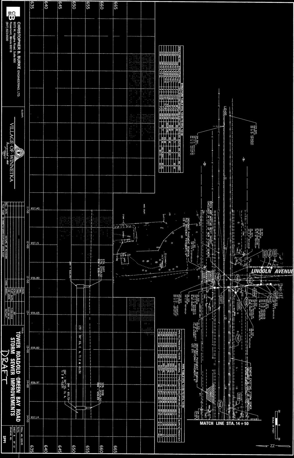
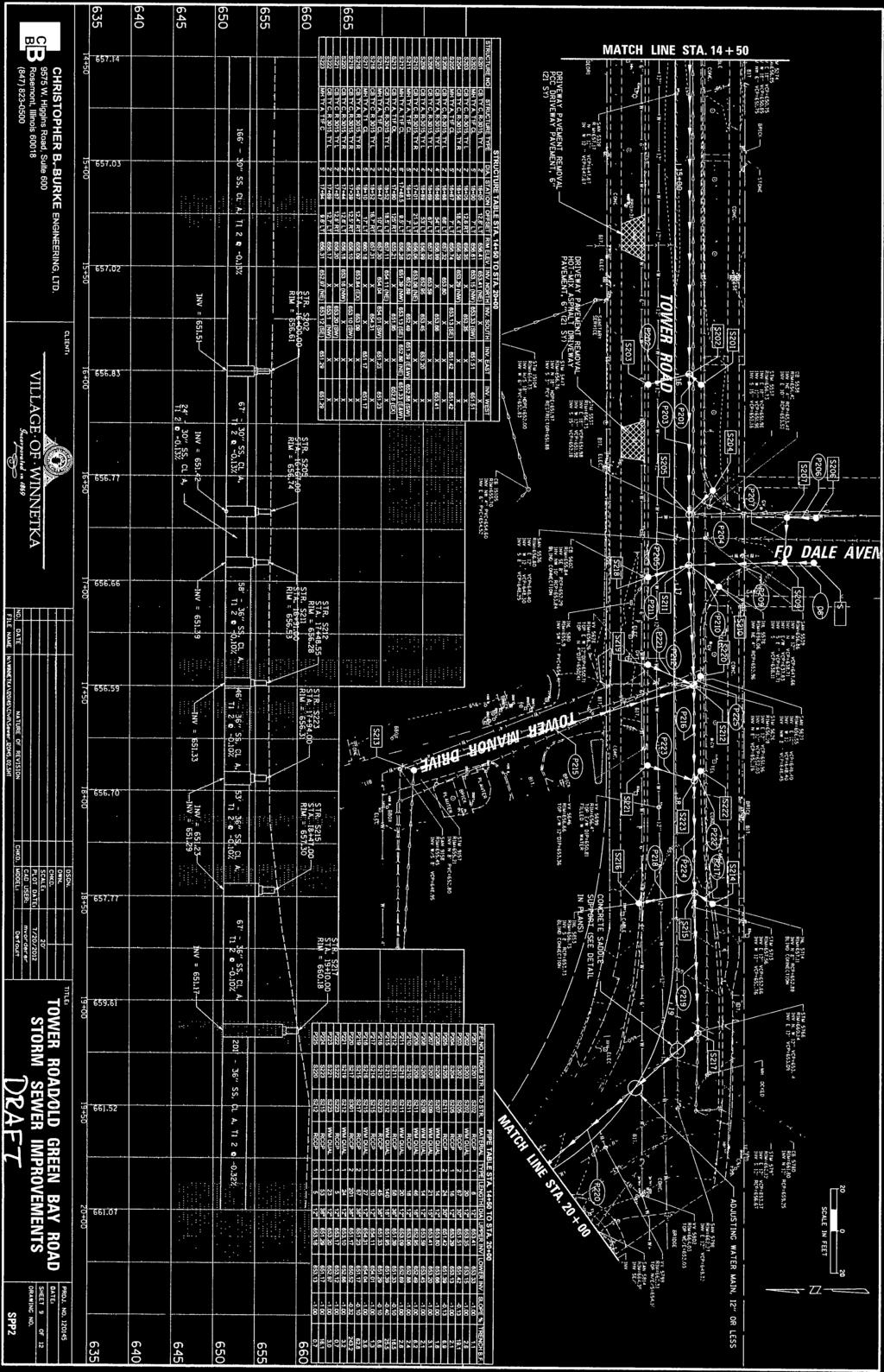
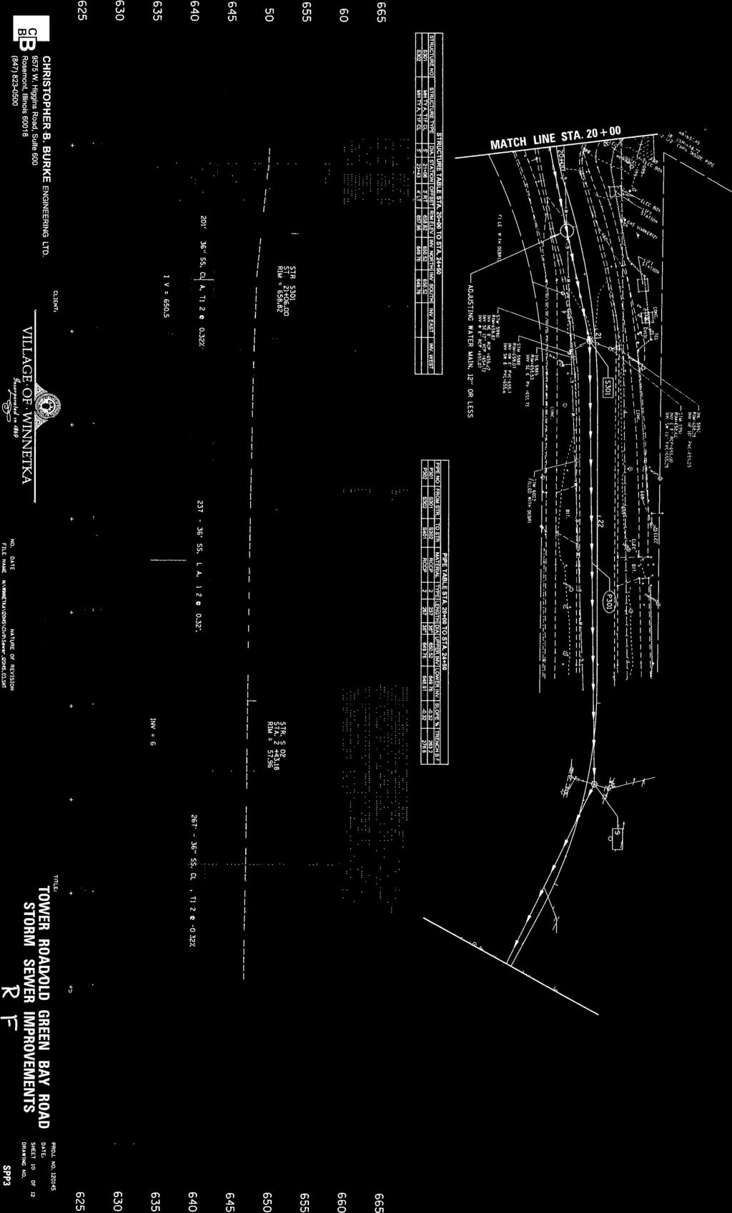
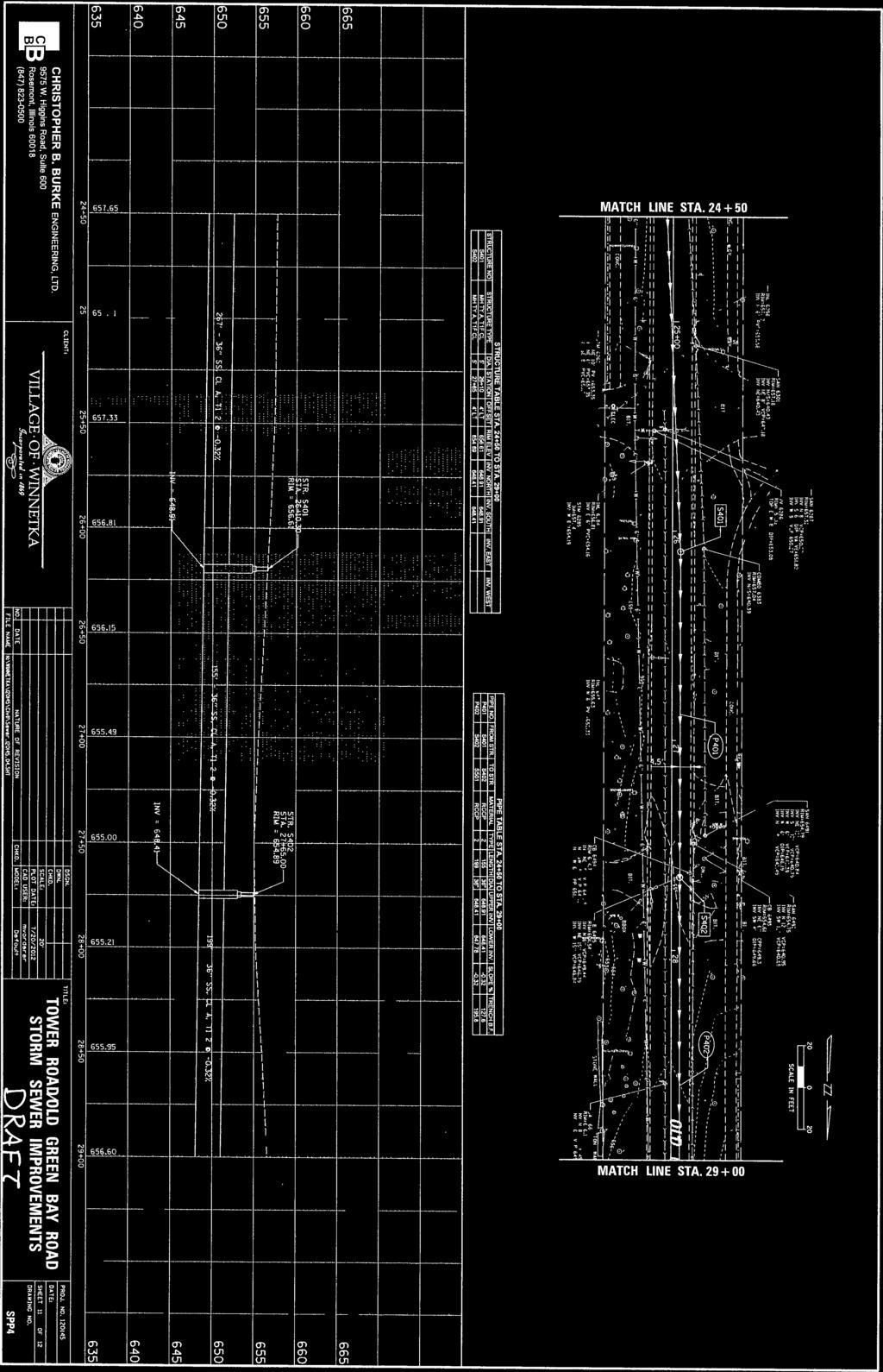
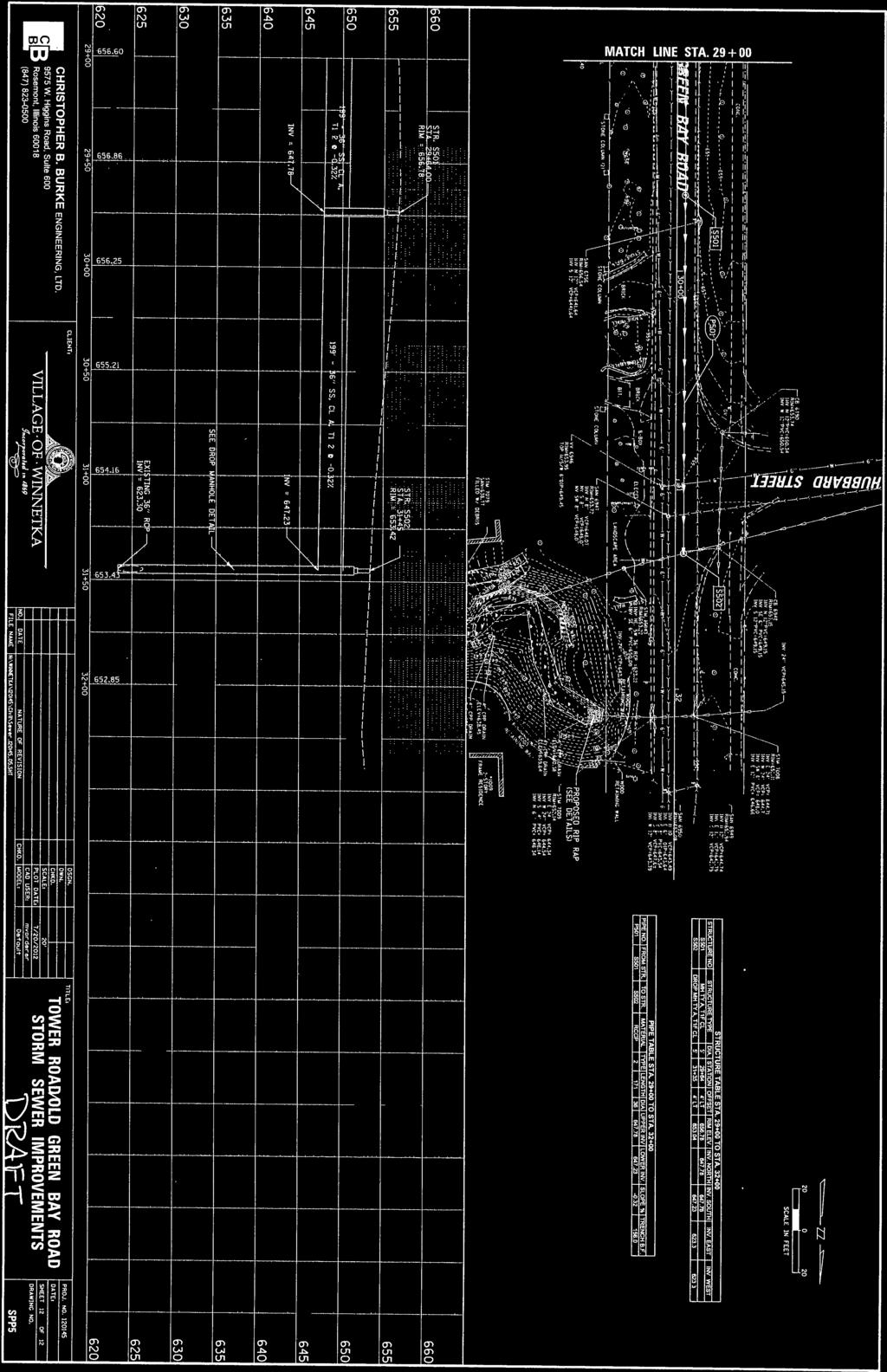
2 discharge structure to assure that it can accommodate the additional flow from the proposed storm sewer. Second, although preliminary discussions are ongoing with Park District staff about the routing of the proposed storm sewer through the parking lot, the routing needs to be finalized, easements obtained, and agreements formalized about parking lot restoration. Tower Road/Old Green Bay Relief Sewer. An additional area of flooding, including overland property damage flooding, is along Tower Road east of Old Green Bay Road. Flooding in this area is primarily caused by three factors 1) insufficient capacity for larger storms in the storm sewer system along Tower Road; 2) insufficient inlet grate capacity to capture water draining north from Foxdale Avenue and Lincoln Avenue; and 3) topography issues wherein properties along the north side of Tower Road are lower than the roadway, so that any significant flooding that does occur in the roadway spills north into these properties. CBBEL has developed a proposed improvement that consists of increased inlet capacity at key locations, and a new storm sewer to convey stormwater west on Tower Road and north along Old Green Bay Road, to an existing storm sewer beneath the ravine that outlets to Lake Michigan. The existing storm sewer primarily drains the Union Pacific Railroad right of way, but also drains a small drainage area west of the railroad tracks. CBBEL has analyzed this storm sewer and has determined that sufficient excess capacity exists to accommodate the additional runoff tributary from the Tower Road area without causing backups into the railroad property. The initial cost estimate for this project was approximately $1,400,000, however the current cost estimate is lower, at approximately $973,000. This is primarily due to further advancement of the engineering allowing more detailed cost estimates for pavement restoration, trench backfill, and other items. Issues Remaining to be Addressed: There is a significant technical issue still to be addressed with the proposed project. The receiving storm sewer that runs beneath the ravine primarily serves as drainage for the railroad right-of-way, but also drains an area of Hubbard Woods centered on Merrill Street. After CBBEL was engaged to complete design work on this proposed improvement, the Village also engaged Baxter & Woodman, as part of the stormwater master planning process, to evaluate the Merrill Street area and develop potential improvements to reduce flood risk in that area. Baxter & Woodman has not yet completed this task, so it is not yet known whether the flow tributary to the ravine storm sewer will remain as it exists today. CBBEL s technical analysis of the existing storm sewer system does not include any potential improvements to the Merrill Street area. If Baxter & Woodman recommends stormwater capacity improvements along Merrill Street that would increase downstream flows, the combination of improvements might create surcharge conditions in the downstream pipe that do not currently exist. It is advisable at this time to wait for the completion of Baxter & Woodman s evaluation of the Merrill Street area before proceeding with final design on the Tower Road project, so that recommended improvements in the two areas can be evaluated in concert with one another. 153
3 A second technical issue involves addressing erosion at the head of the ravine caused by existing roadway drainage from Old Green Bay Road. While the Village s proposed improvements will not affect the amount of water discharging to the ravine, the existing erosion should be addressed while the Village is working in the area. Since the ravine bottom is classified as a wetland, improving the area to address erosion will require a permit from the US Army Corps of Engineers. It is not anticipated that there will be any significant difficulty associated with securing this permit. Recommendation: Review preliminary plans and provide comments. Attachments: 1. Conceptual Plan 2. Preliminary Detailed Plan Sheets 3. CBBEL Technical Memo 154
4 ATTACHMENT 1 CONCEPTUAL PLAN 155

5 Connect to exiting storm sewer system beneath Ravine to Lake Michigan Old Green Bay Rd Ravine to Lake Michigan New 30 to 36 storm sewer to help move flood water away Area susceptible to flooding Existing 18 to 24 storm sewer to remain Tower Rd Flow from south toward Tower Rd Storm sewer to Lake Michigan 156
6 ATTACHMENT 2 PRELIMINARY DETAILED PLAN SHEETS 157
7 158
8 159


9 160
10 161
11 162
12 ATTACHMENT 3 CBBEL TECHNICAL MEMORANDUM 163
 has completed an analysis of the proposed relief storm sewer that will drain the intersections of Tower Road at Foxdale and Lincoln Avenues.")
13 MEMORANDUM June 21 st, 2012 TO: FROM: Steve Saunders, PE Thomas T. Burke, PE Steve Sugg, PE Dave Buckley, PE SUBJECT: Ravine Outlet Old Green Bay Road (CBBEL Project No ) Christopher B. Burke Engineering, Ltd. (CBBEL) has completed an analysis of the proposed relief storm sewer that will drain the intersections of Tower Road at Foxdale and Lincoln Avenues. The need for this improvement was identified for the Spruce Street Outlet study area in the October 2011 Flood Risk Reduction Assessment (25-, 50-, 100-year Protection). The proposed relief sewer will convey runoff north along Old Green Bay Road and outlet to the Ravine at Hubbard Place (Figure 1). 24-inch Culvert Figure 1. Project Location 36-inch Storm Sewer Ravine East to Lake Michigan Proposed Relief Sewer CHRISTOPHER B. BURKE ENGINEERING, LTD W Higgins Road, Suite 600 Rosemont, Illinois Tel (847) Fax (847)

14 MEMORANDUM Existing Conditions There is an existing 36-inch storm sewer that drains the railroad right-of-way as shown in Figure 1. This sewer is approximately 30 feet deep at Old Green Bay Road and flows east underneath the Ravine before outletting to Lake Michigan through a 4-foot by 5-foot concrete box culvert east of Sheridan Road. There is also a 24-inch cross road culvert draining approximately 15 acres of tributary area that outlets to the Ravine east of Old Green Bay Road near the 36-inch storm sewer crossing (Figure 1). The downstream end of the 24-inch culvert is approximately 3 feet above the bottom of the Ravine. The area has become eroded over time as shown in Figure 2. Figure 2. Downstream End of 24-inch Cross Culvert at Old Green Bay Road Analysis This analysis determined the feasibility of connecting the proposed relief sewer to the existing 36-inch storm sewer draining the railroad and/or the 24-inch cross road culvert. The new connections will minimize erosion in the Ravine by avoiding the need for a new outlet for the proposed relief sewer. The Village would also like to provide erosion control measures at the existing 24-inch outlet. CHRISTOPHER B. BURKE ENGINEERING, LTD W Higgins Road, Suite 600 Rosemont, Illinois Tel (847) Fax (847)
15 MEMORANDUM CBBEL completed a field survey that identified the depth on Old Green Bay Road of the 36- inch storm sewer that drains the railroad right-of-way. The upstream invert elevation of the storm sewer at the railroad is unknown. A sensitivity analysis was performed utilizing multiple upstream invert elevations to determine the impact of an assumed invert elevation at the railroad. The 36-inch storm sewer information was entered into XP-SWMM, and the sensitivity analysis showed that the hydraulic grade line is not affected by varying inverts at the upstream end of this pipe. According to the XP-SWMM analysis, the hydraulic grade line in the 36-inch storm sewer is approximately feet at the railroad for the 100-year design storm. The lowest ground elevation in the railroad right-of-way on either side of the tracks is approximately feet. Downstream of Old Green Bay Road, the 36-inch storm sewer can surcharge into the Ravine during very intense storm events. According to the XP-SWMM analysis, the sewer does not surcharge during the 100-year event. The proposed relief sewer was connected to the 36-inch storm sewer at Old Green Bay Road and analyzed in XP-SWMM. The new connection increases the hydraulic grade line to approximately feet at the upstream end in the railroad right-of-way for the 100-year design storm. This is 1 foot below the lowest ground elevation shown on the Cook County 1-foot aerial topography in the railroad corridor. The proposed connection also causes two structures, located at the approximate midpoint of the Ravine, to overflow with approximately 3.5 cfs each. Recommendation The Ravine at Old Green Bay Road has a known erosion problem and it is not recommended that a new outfall for the proposed relief sewer be constructed at this location. We recommend tying the proposed relief sewer into the existing 36-inch storm sewer at Old Green Bay Road. The proposed hydraulic grade line in the existing sewer will remain below the lowest ground elevations in the railroad right-of-way and the overflow from two structures in the bottom of the ravine is minimal. We recommend constructing erosion control measures at the downstream end of the existing 24-inch cross culvert in the Ravine as part of construction of the relief sewer. Erosion control measures at this location will require approval from the US Army Corps of Engineers for maintenance within the area identified as Waters of the US. We will modify the plans and obtain the necessary approval to complete this work as part of the relief sewer project. N:\WINNETKA\120145\Water\Docs\M_old grn bay rd outlet docx CHRISTOPHER B. BURKE ENGINEERING, LTD W Higgins Road, Suite 600 Rosemont, Illinois Tel (847) Fax (847)
Welcome KROSNO CREEK DIVERSION PROJECT CLASS ENVIRONMENTAL ASSESSMENT
 Welcome KROSNO CREEK DIVERSION PROJECT PUBLIC INFORMATION CENTRE # 1 Tonight s Presentation Study Overview Background Existing Conditions Alternative Solutions Preliminary Preferred Solution Next Steps
Final Drainage Letter Pikes Peak Community College Downtown Parking Lot Colorado Springs, Colorado
 Final Drainage Letter Pikes Peak Community College Downtown Parking Lot Colorado Springs, Colorado Prepared for: Pikes Peak Community College 5775 South Academy Boulevard Colorado Springs, CO 80906-5422
Introduction. The System. Model Limitations, Assumptions, and Parameters. Optional Services Tech Memo
 Optional Services Tech Memo Introduction This technical memo evaluates the impact of a tide gate to be installed at the confluence of the Left Bank Tributary of Thalia Creek and Lake Windsor. Specifically,
Photographic Log Client: Project Number: Site Location: Site Name: Photograph ID: Date: Location: Direction: Comments: Photograph ID:
 Photograph ID: 1 west View of one of the monitoring well and the large parking lot on the south side of Center Street. Photograph ID: 2 Monitoring well located in the middle of the parking lot located
RIO VISTA MUNICIPAL AIRPORT
 DRAINAGE TECHNICAL MEMORANDUM RIO VISTA MUNICIPAL AIRPORT RIO VISTA, CALIFORNIA Prepared for: City of Rio Vista 1 Main Street Rio Vista, CA 94571 (707) 374-5337 Prepared by: August 2012 Copyright 2012
Appendix E. System Issues
 Appendix E System Contents Page System... E-1 E.1 Introduction...E-1 E.2 Existing Model - System...E-2 E.2.1 Location: Country Ridge Collector, at Queensgate Drive...E-2 E.3 Committed Model - System...E-3
Project Management, Environmental Assessment, Stormwater Management. Hydrologic Modelling. Natural Heritage. Fluvial Geomorphology
 Welcome PUBLIC INFORMATION CENTRE # 1 KROSNO CREEK DIVERSION PROJECT February 19, 2014 6:30 p.m. to 8:30 p.m. Please sign in on the sheet provided. Then feel free to walk around and view the displays.
Flood History. Floodplain Descriptions
 Flood History The worst flooding in the area took place in 1966, 1969, 1971, 1995 and 1998. The storms in 1966 and 1969 caused considerable damage throughout the area due to flooding, erosion and debris
CITY OF LYNDEN STORMWATER MANAGEMENT PROGRAM REPORT MARCH 1, 2016
 CITY OF LYNDEN STORMWATER MANAGEMENT PROGRAM 2015 WATER QUALITY MONITORING REPORT CITY OF LYNDEN 300 4 TH STREET LYNDEN, WASHINGTON 98264 PHONE (360) 354-3446 MARCH 1, 2016 This document serves as an attachment
Chapter 4.0 Alternatives Analysis
 Chapter 4.0 Alternatives Analysis Chapter 1 accumulated the baseline of existing airport data, Chapter 2 presented the outlook for the future in terms of operational activity, Chapter 3 defined the facilities
Mr. Michael Malone CPS Energy 145 Navarro Street San Antonio, Texas Project No
 January 15, 2016 Mr. Michael Malone 145 Navarro Street San Antonio, Texas 78205 Project No. 0328985 Environmental Resources Management CityCentre Four 840 West Sam Houston Pkwy N. Suite 600 Houston, Texas
DRAFT. Dorabelle Campground Rehabilitation
 DRAFT Dorabelle Campground Rehabilitation September 2012 1.1 REGIONAL SETTING AND PROJECT LOCATION The Dorabelle Campground is located on the western shore of Shaver Lake in Fresno County, California (Section
TRAFFIC COMMISSION, VILLAGE OF LINCOLNWOOD 6900 N. Lincoln Avenue, Lincolnwood, IL 60712
 TRAFFIC COMMISSION, VILLAGE OF LINCOLNWOOD 6900 N. Lincoln Avenue, Lincolnwood, IL 60712 Meeting Agenda - Revised Thursday, March 22, 2018 7:00 p.m. Village Hall Council Chambers 6900 N. Lincoln Ave. Lincolnwood,
Common Ground Drainage Channel Diversion. Design Report
 Common Ground Drainage Channel Diversion Design Report Resource Management International Inc Consulting Engineers May 2017 COMMON GROUND DRAINAGE CHANNEL DIVERSION PREPARED FOR: QUILL LAKES WATERSHED NO.
GILBERT & WEST TOWN INTERCOUNTY DRAIN Windsor Township, Eaton County and City of Lansing, Delhi Township, Ingham County, Michigan
 GILBERT & WEST TOWN INTERCOUNTY DRAIN Windsor Township, Eaton County and City of Lansing, Delhi Township, Ingham County, Michigan PRELIMINARY ENGINEERING REPORT Abigail Eaton, Chair Intercounty Drains
CITY COUNCIL AGENDA MEMORANDUM
 To: Mayor and City Council From: Charles Ozaki, City and County Manager Prepared By: Kevin Standbridge, Deputy City and County Manager Katie Allen, City and County Engineer David Shinneman, Community Development
VI. ALTERNATIVES TO THE MASTER PLAN C. RENOVATED EAST BUILDING ALTERNATIVE
 VI. ALTERNATIVES TO THE MASTER PLAN C. RENOVATED EAST BUILDING ALTERNATIVE INTRODUCTION The Renovated East Building Alternative would include the continued use of the renovated West Building and the renovation
Ditch flows slowly to the north
 Ditch flows slowly to the north Photo 1. Wetland DE: Looking west across Wetland DE from upslope. Ponded water, mucky mineral soils, and patches of emergent vegetation observed. Wetland DE appears to be
SECTION 3 GENERAL DESCRIPTION OF THE RIVER BASIN
 SECTION 3 GENERAL DESCRIPTION OF THE RIVER BASIN SECTION 3 GENERAL DESCRIPTION OF THE RIVER BASIN River basin description. A general description of the river basin or subbasin, as appropriate, in which
Public Notice ISSUED: December 10, 2018 EXPIRES: January 9, 2019
 APPLICANT: REFER TO: St. Louis and Lake Counties Regional Rail Authority 2018-01942-ARC Public Notice ISSUED: December 10, 2018 EXPIRES: January 9, 2019 SECTION:404 - Clean Water Act 1. APPLICATION FOR
Waukegan & Calumet Rivers. All Hands Meeting
 Waukegan & Calumet Rivers 516(e) Update All Hands Meeting David F. Bucaro, P.E. Chief, Economic Formulation & Analysis Section, Planning Branch May 18 th, 2011 Kensington Court Ann Arbor, MI 1 2 Waukegan
APPENDIX F List of Commitments
 APPENDIX F List of Commitments s Table F.1 Standard Mitigation Measures Mitigation Measure MnDOT Specification Number Status Update Description Status Update Utilities Provide early notice to utility operators
PORTISHEAD BRANCH LINE PRELIMINARY ENVIRONMENTAL INFORMATION REPORT VOLUME 4 APPENDIX Water Receptors
 PORTISHEAD BRANCH LINE PRELIMINARY ENVIRONMENTAL INFORMATION REPORT APPENDIX 17. 3 Water Receptors Contents Section Page 1 Water Receptors... 1-1 1.1 Surface Water Features/Receptors in the Study Area
MEETING OF THE METROPOLITAN PARKS AND OPEN SPACE COMMISSION Tuesday, April 4, 2017
 Minutes of the MEETING OF THE METROPOLITAN PARKS AND OPEN SPACE COMMISSION Tuesday, April 4, 2017 Committee Members Present: Tony Yarusso, Rick Theisen, Robert Moeller, Todd Kemery, Sarah Hietpas, Margie
Colombia (South America) Water use and drainage in Colombia. Case Study: The Stormwater Challenge in Barranquilla. Humberto Avila.
 Water use and drainage in Colombia. Case Study: The Stormwater Challenge in Barranquilla. Humberto Avila.") Colombia (South America) Water use and drainage in Colombia Location: Case Study: The Stormwater Challenge in Barranquilla Source: Wikipedia The University of Alabama February 25, 2008 Population: 45 million
Colombia (South America) Water use and drainage in Colombia Location: Case Study: The Stormwater Challenge in Barranquilla Source: Wikipedia The University of Alabama February 25, 2008 Population: 45 million
Metro District 1500 W. County Road B 2 Roseville, MN Date: July 17, 2018
 Metro District 1500 W. County Road B 2 Roseville, MN 55113 3174 Date: July 17, 2018 Ryan Hixson FHWA, Area Engineer Federal Highway Administration 380 Jackson Street, Suite 500 St. Paul, Minnesota 55101
Committee Report. Community Development Committee For the Metropolitan Council meeting of April 13, Business Item No.
 Committee Report Business Item No. 2016-48 Community Development Committee For the Metropolitan Council meeting of April 13, 2016 Subject: Harriet Island-South St. Paul Regional Trail Master Plan, Saint
One East First Street Reno, NV
 AECOM City Hall Tower, 16th Floor One East First Street Reno, NV 89501 www.aecom.com 775.337.9565 tel 916.414.5850 fax Mr. David Whalen, P.E. City of Fernley Public Works 595 Silverlace Blvd. Fernley,
Preliminary Site Evaluation
 Preliminary Site Evaluation 100 Acre Site, US 72 Piperton, Tennessee Power Distributor: Chickasaw Electric Cooperative August 2010 SITE DATA SHEET PIPERTON US 72 SITE (100 ACRES): LOCATION & GENERAL DESCRIPTION
MEMORANDUM. Honorable Mayor and City Councilmembers William S. Joynes, Sr., City Administrator
 AGENDA ITEM 1A MEMORANDUM DATE: January 17, 2017 TO: FROM: SUBJECT: Honorable Mayor and City Councilmembers William S. Joynes, Sr., City Administrator Sue Polka, Interim Asst. Public Works Director/City
RIVER ACCESS STRATEGY
 RIVER ACCESS STRATEGY The River Access Strategy is a 10-year plan the City of Edmonton is developing to inform future programming, operations and infrastructure improvements that support access to the
2013 Regional Water System Improvements Program Public Hearing March 14, 2013
 In support of Illinois Environmental Protection Agency State Revolving Fund Loan Application 2013 Regional Water System Improvements Program Public Hearing March 14, 2013 Village of Oak Lawn Customer Communities:
Town of Danvers Planning Board
 Town of Danvers Planning Board Danvers Town Hall One Sylvan Street Danvers, MA 01923 www.danvers.govoffice.com Margaret Zilinsky, Chair Kristine Cheetham William Prentiss Aaron Henry James Sears John Farmer,
AGAWAM CONSERVATION COMMISSION April 26, 2018
 MEMBERS PRESENT: Henry A. Kozloski, Chairman Sheryl Becker S. Page Fallon Frank Meagher MEMBERS ABSENT: Magda Galiatsos Jill Messick ALSO PRESENT: Pamela R. Kerr AGAWAM CONSERVATION COMMISSION Mr. Kozloski
AGENDA ITEM 5 D WAKULLA ENVIRONMENTAL INSTITUTE (WEI) TRAIL FEASIBILITY STUDY
 TRAIL FEASIBILITY STUDY") March 19, 2018 AGENDA ITEM 5 D WAKULLA ENVIRONMENTAL INSTITUTE (WEI) TRAIL FEASIBILITY STUDY TYPE OF ITEM: Action STATEMENT OF ISSUE The Wakulla Environmental Institute (WEI) Trail is one of several trails
March 19, 2018 AGENDA ITEM 5 D WAKULLA ENVIRONMENTAL INSTITUTE (WEI) TRAIL FEASIBILITY STUDY TYPE OF ITEM: Action STATEMENT OF ISSUE The Wakulla Environmental Institute (WEI) Trail is one of several trails
City of Peoria Clean Water Efforts. Governor s s Conference on the Management of the Illinois River October 4, 2007
 City of Peoria Clean Water Efforts Governor s s Conference on the Management of the Illinois River October 4, 2007 1 What do you call dinner and a movie with an unemployed guy? An unfunded man-date! 2
MEMORANDUM VILLAGE OF NORTHBROOK
 MEMORANDUM VILLAGE OF NORTHBROOK TO: Staff COPY: Village President & Board of Trustees Department Heads FROM: Richard Nahrstadt, Village Manager DATE: April 29, 2016 SUBJECT: STAFF BRIEFING WEEK OF April
White Mountain National Forest. Campton Day Use Area Development Project. Scoping Report. Prepared by the Pemigewasset Ranger District May 2013
 White Mountain National Forest Campton Day Use Area Development Project United States Department of Agriculture Forest Service Eastern Region Towns of Thornton and Campton, Grafton County, NH Scoping Report
United States Department of the Interior National Park Service. Boundary Expansion Listed in National Register January 11, 2017
 NPS Form 10900-a (Rev. 8/2002) OMB No. 10240018 United States Department of the Interior National Park Service Boundary Expansion Listed in National Register January 11, 2017 National Register of Historic
Port Everglades Master/Vision Plan Update
 Port Everglades Master/Vision Plan Update Environmental Stakeholder Meeting June 15, 2009 Discussion to Focus On: Updating the 2006 Port Everglades Master Plan Issues dealing with the Turning Notch Potential
HIGH SPEED RAIL CROSSING WITH FLANGE-BEARING CROSS TRAFFIC. UPRR/TPW Crossing in Chenoa, IL
 HIGH SPEED RAIL CROSSING WITH FLANGE-BEARING CROSS TRAFFIC UPRR/TPW Crossing in Chenoa, IL Written By Michael R. Garcia, P.E. Chief, Rail Engineering Bureau of Railroads Room 302 Illinois Department of
Bear Creek Habitat Improvement Project
 06/10/10 Bear Creek Habitat Improvement Project El Paso County, Colorado Pike National Forest and Colorado Springs Utilities Owned Land Report prepared by: Eric Billmeyer Executive Director Rocky Mountain
The Holes Creek Bridge Replacement By Bradley McClelland
 The Holes Creek Bridge Replacement By Bradley McClelland Each time there is a heavy rainstorm, the folks along Sheffield Road in the Dayton, Ohio suburb of West Carrollton have cause to be concerned. Holes
SECTION 106 ACTIVITIES ANNUAL REPORT
 SECTION 106 ACTIVITIES ANNUAL REPORT FOR THE YEAR ENDING DECEMBER 31, 2011 Metropolitan Washington Airports Authority 1593 Spring Hill Road, Suite 300 Vienna, Virginia 22182 JANUARY 2012 Introduction The
With the first portion of this process complete, we anticipate the general timeline for the remainder of the process to be:
 THE CITY OF FIRE RESCUE E D M O N T O N FIRE RESCUE SERVICES 10351 96 Street Edmonton, Alberta T5H 2H5 April 19, 2013 Dear Rossdale residents: As many of you know, Fire Rescue Services is currently in
14.1.a. Attachment: Engineering Standards Manual Draft (2016 : Approval of the Engineering Standards Manual) Packet Pg. 216
 Packet Pg. 216") Packet Pg. 216 City of Fort Walton Beach Manual November 2012 14.1.a City of Fort Walton Beach Manual TABLE OF CONTE SECTION 1.00 INTRODUCTION... 3 SECTION 2.00 POLICY... 3 SECTION 3.00 - EROSION AND SEDIMENTATION
Packet Pg. 216 City of Fort Walton Beach Manual November 2012 14.1.a City of Fort Walton Beach Manual TABLE OF CONTE SECTION 1.00 INTRODUCTION... 3 SECTION 2.00 POLICY... 3 SECTION 3.00 - EROSION AND SEDIMENTATION
SECTION 106 ACTIVITIES ANNUAL REPORT
 SECTION 106 ACTIVITIES ANNUAL REPORT FOR THE YEAR ENDING DECEMBER 31, 2014 Metropolitan Washington Airports Authority 198 Van Buren Street, Suite 300 Herndon, Virginia 20170 JANUARY 2015 Introduction The
Trail Assessment Report
 Trail Assessment Report Trail Options for the Bear Creek Canyon located in Pikes Peak Ranger District, Pike National Forest and on Colorado Springs Utility Lands Due to the presence of a unique species
II. THE BOULDER CREEK DRAINAGE BASIN
 II. THE BOULDER CREEK DRAINAGE BASIN This section provides an overview of the watersheds and flood hazards associated with Boulder Creek and South Boulder Creek including descriptions of the drainage basins,
Mt. Hood National Forest
 United States Department of Agriculture Forest Service Mt. Hood National Forest Zigzag Ranger District 70220 E. Highway 26 Zigzag, OR 97049 503-622-3191 Fax: 503-622-5622 File Code: 1950-1 Date: June 29,
Brevard County Utility Services Department
 Brevard County Utility Services Department April 3, 2018 Jim Helmer, Department Director Brian Sorensen, W/WW Manager 1 Utility Services Department 9 TREATMENT PLANTS 6 WASTEWATER, 3 WATER 163 EMPLOYEES
CENTER PIVOT TRACK MANAGEMENT OPTIONS
 Proceedings of the 28th Annual Central Plains Irrigation Conference, Kearney, Nebraska, February 23-24, 2016 Available from CPIA, 760 N. Thompson, Colby, Kansas CENTER PIVOT TRACK MANAGEMENT OPTIONS Steven
Some Historical Aspects of Urban Water Systems
 Some Historical Aspects of Urban Water Systems Robert Pitt Department of Civil and Environmental Engineering University of Alabama Tuscaloosa, AL 35487 Ancient springs at Delphi, Greece (site of Oracle)
Groundwater Recharge/Discharge Y 1, 2, 3, 4, 5, 16 X Wetland appears to be a contiguous hydraulic system, draining towards Goff Mill Brook.
 Wetland Function-Value Evaluation Form Total area of wetland: Human made? No Is wetland part of a wildlife corridor? Yes or a habitat island? Adjacent land use Rt. 1, Commercial, undeveloped forest Distance
FEASIBILITY CRITERIA
 This chapter describes the methodology and criteria used to evaluate the feasibility of developing trails throughout the study areas. Land availability, habitat sensitivity, roadway crossings and on-street
Resolution Ordinance Motion Discussion Only
 ITEM MOT 00-05169 VILLAGE OF DOWNERS GROVE REPORT FOR THE VILLAGE COUNCIL MEETING MARCH 19, 2013 AGENDA SUBJECT: TYPE: SUBMITTED BY: Concord Square Unit 2 Roadway Improvements & Streetlight Replacement
Construction Staging Adelaide Street West
 REPORT FOR ACTION Construction Staging Adelaide Street West Date: October 6, 2016 To: Toronto and East York Community Council From: Acting Director, Transportation Services, Toronto and East York District
TRINITY RIVER CORRIDOR
 TRINITY RIVER CORRIDOR MODIFIED DALLAS FLOODWAY PROJECT UPDATE May 12, 2015 Jon Loxley Project Manager Dallas Floodway Project Fort Worth District U.S. Army Corps of Engineers US Army Corps of Engineers
North Cruise Berth Projects PortMiami
 North Cruise Berth Projects PortMiami AAPA 2017 Facilities Engineering Seminar Oct 24 26, 2017 Carlos J. Arboleda, PE Vice President Project Director Intermodal Ports 1 PortMiami The Cruise Capital of
Virginia Department of Transportation s Rural Rustic Road Program
 Virginia Department of Transportation s Rural Rustic Road Program Prepared by the Local Assistance Division Virginia Department of Transportation 1401 East Broad Street Richmond, Virginia 23219 Michael
LAS VARAS RANCH CA COASTAL TRAIL PROPOSED ALIGNMENT
 LAS VARAS RANCH CA COASTAL TRAIL PROPOSED ALIGNMENT Santa Barbara Trails Council * Prepared by Ray Ford February 1,2012 The following notes accompany the Santa Barbara Trails Council map for the Las Varas
David Johnson. Tom, Attached please find the final scoping letter and figures for your review. David
 David Johnson From: Sent: To: Cc: Subject: Attachments: David Johnson Tuesday, April 12, 2011 4:33 PM Thomas Malecek Dave Dyer; Jason Marks (jmarks@segroup.com) VWC Scoping Letter
The combined Planning and Zoning and Council Meeting was called to order at 7:00 p.m.
 Lake Remediation Master Plan The combined Planning and Zoning and Council Meeting was called to order at 7:00 p.m. Roll Call: Councilman Joe Curl, Councilwoman Tiffany Hughes, Councilwoman Lori Howard,
Appendix L Technical Memorandum Aesthetics
 Technical Memorandum Aesthetics 1.0 AESTHETICS This section provides a discussion of the aesthetic resources in the vicinity of ARTIC. Aesthetics pertain to the elements that make a certain view pleasing
Bradley Brook Relocation Project. Scoping Notice. Saco Ranger District. United States Department of Agriculture Forest Service
 Bradley Brook Relocation Project United States Department of Agriculture Forest Service Scoping Notice White Mountain National Forest February 2011 For Information Contact: Jenny Burnett White Mountain
Northern Rail Extension, Phase One
 General Project and Funding 1. Where does Phase One start? The rail line for Phase One begins roughly at the northern boundary of the former Bradbury property, but also includes work along Tom Bear Trail
Spencer Environmental Appendix A: Alternative Analysis for Construction Access Route
 Spencer Environmental Appendix A: Alternative Analysis for Construction Access Route February 2015 Valley ine-stage 1 RT EISA Update FINA REPORT Page A1 Memorandum AECOM ConnectEd Transit Partnership 10235
International Osoyoos Lake Board of Control Annual Report to the International Joint Commission
 International Osoyoos Lake Board of Control 2010 Annual Report to the International Joint Commission TABLE OF CONTENTS ACTIVITIES OF THE BOARD... 1 HYDROLOGIC CONDITIONS IN 2010... 2 Drought Criteria...
China Creek North Park Upgrades and Glen Pump Station. Park Board Committee Meeting Monday, July 10, 2017
 China Creek North Park Upgrades and Glen Pump Station Park Board Committee Meeting Monday, July 10, 2017 Purpose The purpose of this presentation is to: Share the results of the public engagement processes;
ADDENDUM 2 APPENDIX D STANDARD DRAWINGS
 ADDENDUM 2 APPENDIX D STANDARD DRAWINGS Overview This Addendum to Appendix D Standard Drawings replaces Standard Drawing Figures 001 to 020 with new Standard Drawings EDCM 301 to EDCM 704 - as listed below.
Proposed At-grade Crossings of Officially Recognized Trails Port MacKenzie Rail Extension Project
 Proposed At-grade Crossings of Officially Recognized Trails Port MacKenzie Rail Extension Project 1.0 Introduction On November 21, 2011 the Surface Transportation Board (STB) issued a final decision (Docket
APPENDIX D: Open Water Strata and Land Site Locations and Descriptions
 APPENDIX D: Open Water Strata and Land Site Locations and Descriptions Open Water Strata: Marine Waters W1 St. Joseph Sound W3 Clearwater Harbor south W5 Long Bayou/Cross Bayou W7 Boca Ciega Bay central
Decision Memo for Desolation Trail: Mill D to Desolation Lake Trail Relocation
 for Salt Lake County, Utah Uinta-Wasatch-Cache National Forest Salt Lake Ranger District 1. Background The present location of the Desolation Trail (#1159) between Mill D and Desolation Lake follows old
Fairfax County Parkway Widening Fairfax County
 Get Involved VDOT representatives will review and evaluate information received as a result of this meeting. Please fill out the comment sheet provided in this brochure if you have any comments or questions.
Hydraulic Report. Trail 5 Snowmobile Trail Over Mulligan Creek. Prepared By: COLEMAN ENGINEERING COMPANY Karisa V. Falls, P.E.
 Prepared for: Prepared by: Marquette County Road Commission Coleman Engineering Company Marquette, Michigan Iron Mountain, MI December 2011 Hydraulic Report Trail 5 Snowmobile Trail Over Mulligan Creek
NPS Form a OMB No (8-86) Expires
 Expires") Section: F Page 247 Railroads in Minnesota, 1862-1956 Figures Railroad Roadway Edge of Right of Way Edge of Right of Way Railroad Bed Figure 1. Railroad Corridor, Young America vicinity, ca. 1915 Section:
Section: F Page 247 Railroads in Minnesota, 1862-1956 Figures Railroad Roadway Edge of Right of Way Edge of Right of Way Railroad Bed Figure 1. Railroad Corridor, Young America vicinity, ca. 1915 Section:
RAILROAD QUIET ZONE PROJECT
 RAILROAD QUIET ZONE PROJECT VILLAGE OF ROSELLE Village of Roselle 31 S. Prospect Street Roselle, IL 60172 9575 WEST HIGGINS ROAD, SUITE 600 ROSEMONT, IL 60018 TEL. (847) 823-0500 FAX (847) 823-0520 Table
Community Development Department Council Chambers, 7:30 PM, October 4, Related Case P: Site Plan Approval
 STAFF REPORT 2018-34P: Street Vacation Community Development Department Council Chambers, 7:30 PM, October 4, 2018 To: From: Re: Paul Luke, Chairman, Skokie Plan Commission Mike Voitik, Associate Planner
Hospital Link Project Project Update Winter 2018
 Hospital Link Project Project Update Winter 2018 General The project provides a link from Riverside Drive and the Transitway to the Hospital Link Road. Construction of the Hospital Link facility is open
Washington County Ostrum Trail North/Broadway Street (CSAH 4)
") Washington County Ostrum Trail North/Broadway Street (CSAH 4) Open House Agenda Introductions Project Presentation Group Questions & Answers Breakout Sessions by Zones Discuss project details, issues,
Washington County Ostrum Trail North/Broadway Street (CSAH 4) Open House Agenda Introductions Project Presentation Group Questions & Answers Breakout Sessions by Zones Discuss project details, issues,
City of Madison, Buckeye Road Monona Drive to Stoughton Road County AB Dane County Public Involvement Meeting
 City of Madison, Buckeye Road Monona Drive to Stoughton Road County AB Dane County Public Involvement Meeting Wednesday, May 31, 2017 6:30 to 8 P.M. Frank Allis Elementary School 4201 Buckeye Road Madison,
Memorandum. To: From: cc: Date: November 7, Re: 1.0 Purpose and Organization of this Addendum. 2.0 Project Description
 Memorandum To: From: cc: Laura Prickett, Horizon Water and Environment Analette Ochoa and Wana Chiu, WRECO Parag Mehta, Kimley Horn Date: November 7, 2017 Re: Santa Cruz Route 1 Tier I and Tier II HOV
VRE Manassas Park Station Parking Expansion Alternatives Analysis
 VRE Manassas Park Station Parking Expansion Alternatives Analysis Summary Report September 18, 2017 THIS PAGE INTENTIONALLY LEFT BLANK Table of Contents 1.0 Introduction... 1 2.0 Summary of Existing Conditions...3
1 PLANNING BOARD COUNTY OF ALBANY
 1 PLANNING BOARD COUNTY OF ALBANY 1 2 TOWN OF COLONIE 3 ***************************************************** CORE MATERIALS 4 113 KARNER ROAD SKETCH PLAN 5 *****************************************************
TRANSMITTAL. Please contact me with any questions. 7 Spruce Road, Freeport, ME T: (207)
") BAKER DESIGN CONSULTANTS Civil, Marine and Structural Engineering To: Alex Jaegerman FAICP Director of Planning & Development Town of Yarmouth 200 Main Street PO Box 907 Yarmouth, ME 04096 From: Barney
BAKER DESIGN CONSULTANTS Civil, Marine and Structural Engineering To: Alex Jaegerman FAICP Director of Planning & Development Town of Yarmouth 200 Main Street PO Box 907 Yarmouth, ME 04096 From: Barney
Hydrological study for the operation of Aposelemis reservoir Extended abstract
 Hydrological study for the operation of Aposelemis Extended abstract Scope and contents of the study The scope of the study was the analytic and systematic approach of the Aposelemis operation, based on
Appendix A Appendix A (Project Specifications) Auk Auk / Black Diamond (Trail 44) Reroute
 Auk Auk / Black Diamond (Trail 44) Reroute") Appendix A (Project Specifications) Auk Auk / Black Diamond (Trail 44) Reroute I. Proposed Action: This project proposes to reroute approximately 1,800 feet of a 50 inch wide trail, off of private property
Appendix A (Project Specifications) Auk Auk / Black Diamond (Trail 44) Reroute I. Proposed Action: This project proposes to reroute approximately 1,800 feet of a 50 inch wide trail, off of private property
San Antonio's River Walk Behind the scenes tour or did you know?
 San Antonio's River Walk Behind the scenes tour or did you know? Robert B. Kauffman, Ph.D 7 Hill Top Drive Frostburg, MD 21532 o: (301) 687-4474 e: rkauffman@frostburg.edu All historical slides are from
Chuckanut Ridge Fairhaven Highlands EIS Scoping Concerns
 Chuckanut Ridge Fairhaven Highlands EIS Scoping Concerns Coalition of Southside Neighborhoods CSN Comments for Fairhaven Highlands EIS Scope Hearing, Jan 16, 2008 1 Chuckanut Ridge Hilly Terrain: Potential
TORONTO TRANSIT COMMISSION REPORT NO.
 Revised: March/13 TORONTO TRANSIT COMMISSION REPORT NO. MEETING DATE: November 18, 2013 SUBJECT: YONGE-EGLINTON AND EGLINTON WEST INTERCHANGE STATIONS METROLINX EGLINTON CROSSTOWN LIGHT RAIL TRANSIT PROJECT
C. APPROACH FOR IDENTIFYING THE BEST ROUTES FOR THE NEEDED TRANSMISSION SYSTEM IMPROVEMENTS
 C. APPROACH FOR IDENTIFYING THE BEST ROUTES FOR THE NEEDED TRANSMISSION SYSTEM IMPROVEMENTS CL&P s approach for identifying the best routes for the needed transmission system improvements included a determination
STAFF REPORT. Airport Land Use Consistency Determination Betteravia Plaza. MEETING DATE: January 21, 2016 AGENDA ITEM: 8D
 STAFF REPORT SUBJECT: Airport Land Use Consistency Determination Betteravia Plaza MEETING DATE: AGENDA ITEM: 8D STAFF CONTACT: Andrew Orfila RECOMMENDATION: Adopt findings for the Betteravia Plaza project
White Mountain National Forest Saco Ranger District
 United States Department of Agriculture Forest Service White Mountain National Forest 33 Kancamagus Highway Conway, NH 03818 Comm: (603) 447-5448 TTY: (603) 447-3121 File Code: 1950 Date: February 26,
Clackamas County Development Agency
 Clackamas County Development Agency Development Services Building, 150 Beavercreek Rd., Oregon City, OR 97045 www.clackamas.us/transportation/renewal 503-742-4323 The Clackamas County Board of Commissioners
Mount Rainier National Park November 2006 Flood Damage
 On November 6 and 7, 2006, Mount Rainier National Park received 18 inches of rain in 36 hours. This presentation summarizes the extensive flood damage that occurred throughout the park. Updated November
Welcome to the Illinois High-Speed Rail Chicago to St. Louis Construction Update Meeting. Today s meeting will provide an overview of the Program,
 Welcome to the Illinois High-Speed Rail Chicago to St. Louis Construction Update Meeting. Today s meeting will provide an overview of the Program, updates on construction to be held in this area, and how
The Rains at Kennesaw Mountain - Its Daily Impact
 The Rains at Kennesaw Mountain - Its Daily Impact Sherman wrote that, prior to arriving at Kennesaw Mountain in June 1864, it had rained for 19 straight days. One of his soldiers said 21 days of rain.
ROAD AND TRAIL PROJECT APPROVAL
 ROAD AND TRAIL PROJECT APPROVAL www.marincountyparks.org Marin County Parks, 3501 Civic Center Dr, Suite 260, San Rafael, CA 94903 DATE: July 12, 2017 PRESERVE: Gary Giacomini Open Space Preserve PROJECT:
Figure 1 shows the evaluation area around Tailings Basin Cells 2E/1E. Two areas were evaluated for potential wetland impacts including:
 Barr Engineering Company 4700 West 77th Street Minneapolis, MN 55435-4803 Phone: 952-832-2600 Fax: 952-832-2601 www.barr.com An EEO Employer Minneapolis, MN Hibbing, MN Duluth, MN Ann Arbor, MI Jefferson
COMMUNITY MEETING NOVEMBER 1, Wheaton Regional Park Pine Lake Trail
 COMMUNITY MEETING NOVEMBER 1, 2012 MEETING AGENDA I. Introduction of Project Team II. Trail Renovation Process III. Wheaton Regional Park IV. Pine Lake Trail Renovation Project V. Comments and Questions