AGENDA ITEM 5 D WAKULLA ENVIRONMENTAL INSTITUTE (WEI) TRAIL FEASIBILITY STUDY
|
|
|
- Paulina Bruce
- 5 years ago
- Views:
Transcription
 that will link to the Coastal Trail (US 98) in Wakulla County (currently under construction).")
1 March 19, 2018 AGENDA ITEM 5 D WAKULLA ENVIRONMENTAL INSTITUTE (WEI) TRAIL FEASIBILITY STUDY TYPE OF ITEM: Action STATEMENT OF ISSUE The Wakulla Environmental Institute (WEI) Trail is one of several trails (proposed) that will link to the Coastal Trail (US 98) in Wakulla County (currently under construction). Since August of 2018 Kimley- Horn and Associates (KHA), under the General Planning Consultant (GPC) contract, evaluated several options to link the Coastal Trail to the WEI. CRTPA staff is seeking acceptance of the options and the report that will be presented by KHA. RECOMMENDED ACTION Option 1: Accept the Wakulla Environmental Institute (WEI) Trail Feasibility Study HISTORY AND ANALYSIS As the Coastal Trail projects continue to move forward, CRTPA staff initiated some smaller efforts that will link facilities to the Capital City to the Sea/Coastal Trail. Wakulla Environmental Institute (WEI) Trail (Crawfordville Road to Coastal Trail) A portion (.75 miles) of this trail was constructed (US 319 Crawfordville Road to the WEI) when the WEI was built. However, a connection to the Coastal Trail would further WEI efforts of environmental conservancy, sustainability, and education. The Wakulla Environmental Institute (WEI) Trail Feasibility Report, shown as Attachment 1, details the project activities, including the development of alternatives for Board consideration. However, for this trail project to move forward there are several steps needing to occur that are out of the purview of CRTPA staff and revolve around the development of an adjacent property. When, and if, this property is developed obviously relies on the developer and Wakulla County. Therefore, any recommendation by CRTPA staff will be based upon the results of this effort. NEXT STEPS Waiting. CRTPA staff can provide better direction once the development process of the property adjacent to the WEI is completed. However, staff will continue to follow that effort to ensure that once a decision is made the item will be addressed.
2 Agenda Item 5 D WEI Trail Feasibility Study MARCH 19, 2018 PAGE 2 OPTIONS Option 1: Accept the Wakulla Environmental Institute (WEI) Trail Feasibility Study (Recommended) Option 2: Provide other direction. ATTACHMENT Attachment 1: Wakulla Environmental Institute (WEI) Trail Feasibility Study

")

3 ATTACHMENT 1 WAKULLA ENVIRONMENTAL INSTITUTE (WEI) TRAIL FEASIBILITY STUDY JANUARY 24, 2018 Prepared for: Prepared by
 to the Coastal Trail along U.S. 98 which is currently being constructed. The Coastal Trail is a shared-use path along U.S. 98 which will connect the existing Tallahassee-St.")
 which focuses on environmental conservancy, sustainability, and education which is located in Wakulla County near U.S. 98.")
4 WAKULLA ENVIRONMENTAL INSTITUTE (WEI) TRAIL FEASIBILITY STUDY Introduction Photo 1: Coastal Trail Currently in Construction The Capital Region Transportation Planning Agency (CRTPA) is completing a trail feasibility study to connect the Wakulla Environmental Institute (WEI) to the Coastal Trail along U.S. 98 which is currently being constructed. The Coastal Trail is a shared-use path along U.S. 98 which will connect the existing Tallahassee-St. Marks Historic Railroad State Trail to the existing Ochlockonee Bay Trail in Panacea. This connection will create over 50 miles of shared-use paths between Leon County and Wakulla County. The WEI is a branch of Tallahassee Community College (TCC) which focuses on environmental conservancy, sustainability, and education which is located in Wakulla County near U.S. 98. By developing a connection from the WEI to the Coastal Trail, opportunities for safe transportation to the institute in addition to recreational opportunities such as ecotourism, 5k, running events, and field trips will become a reality. This feasibility analysis is being conducted to identify the route that will be cost effective while maximizing the connection to educational services at the WEI from the Coastal Trail. The overall goal of this analysis will be to increase connections between the schools, neighborhoods, recreational areas, and the WEI with limited use of the roadways. The Importance the Regional Trail Network Photo 2: Wakulla Environmental Institute The creation of this regional trail system presents the opportunity for significant economic and recreation benefits to both residents and visitors in the CRTPA Region. This regional trail network will draw visitors from around the country and even internationally to experience the natural and aesthetic beauty of the area. An increase in trail users will promote a positive economic impact to the area through increased visitation and tourism. Tourism created by trails and other passive recreation resources (parks, conservation areas, etc.) will also draw visitors to nearby hotels and local businesses, while having little negative impact on the community. Typically, passive recreation tourists travel to experience the natural and aesthetic beauty of the trail systems and will likely strive to leave the local environment unimpacted. By connecting the WEI to this trail network, additional educational opportunities with the local schools and businesses will become a reality. Figure 1 depicts the regional trail connectivity around the WEI. Page 2 of 29


5 Figure 1: Regional Trail Network Page 3 of 29

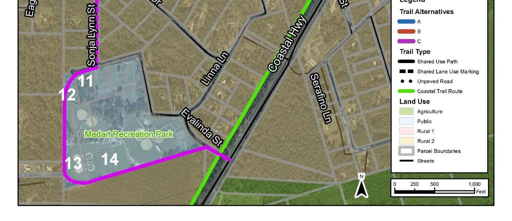
6 Existing Conditions Wakulla Environmental Institute Representatives from WEI were a major stakeholder in the development of the Capital City to Sea Trail Master Plan (Adopted in 2013) and has continued to support the regional trail system. Prior to the completion of their first facility at WEI, they committed early in the planning stages to serve as a major trailhead to the growing trail network in Wakulla County. As construction on the WEI facility began in 2015, trail head amenities including bathrooms, a shared use path, water fountains, and bicycle parking were included. The main entrance road was even constructed with a shared use path that connects to U.S. 319 In addition to its current educational services, the WEI is planning the creation of a conference center with the intent of bringing visitors from around the world. Having a direct connection to the regional trail system will allow visitors to the WEI to explore the area and may generate new economic development in Wakulla County. U.S. 319 Widening Photo 3: Shared use path along the WEI entrance road connects to U.S. 319 U.S. 319 is currently under design for expansion to a 4-lane highway with 5-foot bike lanes/shoulders on both sides. With the planned expansion and bike facilities along U.S. 319, improved connectivity can be achieved between Crawfordville and WEI. Trail Alternatives Three trail alternatives (A, B, and C) have been identified as potential connections between the Wakulla Environmental Institute (WEI) and the U.S. 98 Coastal Trail. Each of the proposed alternatives will require the acquisition of right of way or easements to utilize small portions of public and private property. All three trail alternatives will begin at the trailhead facility on the eastern side of the WEI complex. The existing conditions and the three trail alternatives are described below and depicted within Figures 1, 2, 3, and 4. General Conditions and Considerations Land Use Each of the trail alternatives will traverse the following three land use types: Agriculture Public Rural 1 Neither of the three alternatives are anticipated to negatively affect the land uses or the character of the area. The trail alternatives will provide increased access between two major public land uses in the area (Recreation Park and Wakulla Middle School Medart). Increased access to education and recreation facilities may greatly improve the safety and cohesion of the neighborhoods in the area. Figure 2 depicts the three alternatives and the surrounding land uses. Environmental Much of the area surrounding the WEI has remained natural with light residential development and two public areas nearby (Medart Recreation Park and the Wakulla Middle School). The natural features of this Page 4 of 29
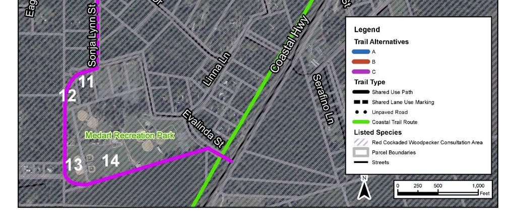
7 area create favorable conditions for a trail with the potential for much of the trail to remain under tree canopy. The alternatives are within the Red Cockaded Woodpecker Consultation Area, meaning extra precaution will be necessary to ensure this species is not negatively impacted once design and construction begins. To the extent feasible, impacts to mature pine forests, including longleaf pines and southern pines will be avoided to reduce the potential for negative impact to these species. Additional analysis will be necessary to identify the potential impact to additional species in the area based on the chosen alternative. Figure 3 depicts the three alternatives and the known species locations and consultation areas. Flood Zone and Wetlands Each of the proposed alternatives is primarily located within Flood Zone X, indicating a moderate flood hazard area susceptible to a 500-year flood event. Alternatives A and B may reach Flood Zone A at the connection with the Coastal Trail on Wildwood drive. The shared lane use markings from alternatives A and B will remain on the existing roadway and are not anticipated to have any effect on the flood zone. National Wetlands Inventory (NWI) data was used to identify known wetlands in the project area. There are very few wetlands present nearby to Alternatives A and B but Alternative C will likely bisect an identified wetland that surrounds Sonja Lynn St. In this location, the proposed trail will remain on the existing roadway as shared lane use markings, so impacts to wetlands are not anticipated. A wetland evaluation will be conducted during the environmental phase of design. Figure 4 depicts the three routes, flood zones, and the locations of known wetlands in the area. Page 5 of 29


8 Figure 2: Land Use Page 6 of 29


9 Figure 3: Listed Species Page 7 of 29


10 Figure 4: Flood Zone and Wetlands Page 8 of 29
11 Historic and Cultural Available State Historic Preservation Office (SHPO) data was mapped to locate any known historic or culturally significant resources near the trail alternatives. The historic York Donaldson Cemetery is just south of the Wakulla Middle School, so the alternatives are not anticipated to negatively impact this resource. Several historic structures and an additional cemetery are located along Crawfordville Highway, but it is unlikely that the trail alternatives will impact these resources. A cultural resource assessment will be completed during the environmental phase of design to ensure no unknown resources will be impacted by the preferred trail alignment. Figure 5 depicts the three alternative routes and the historic York Donaldson Cemetery. Roadway Connections Each of the trail alternatives proposes the use of roadways to minimize the purchase of, or impacts to private properties. By using the existing road network, the need for parcel acquisition or access easements will be greatly reduced, thereby decreasing the potential cost. Several connections are planned as transition points from shared use paths into shared lane markings on the existing residential roadways. Each of the paved roadways have a posted speed limit of 25 MPH, which allows for the safe implementation of shared lane markings. Because of the low speeds and low traffic volumes on these roadways, shared lane markings can be used to provide a safe and cost feasible option for the trail alternatives. Page 9 of 29
12 Figure 5: Historic and Cultural Features Page 10 of 29

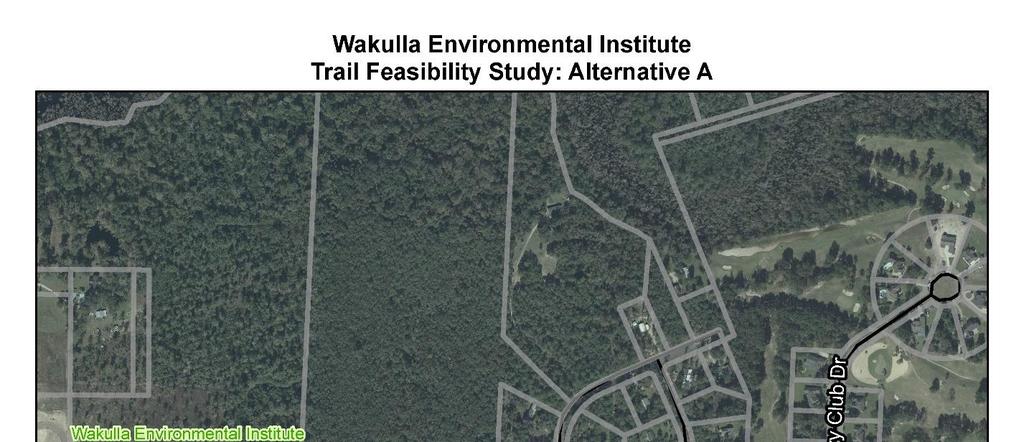
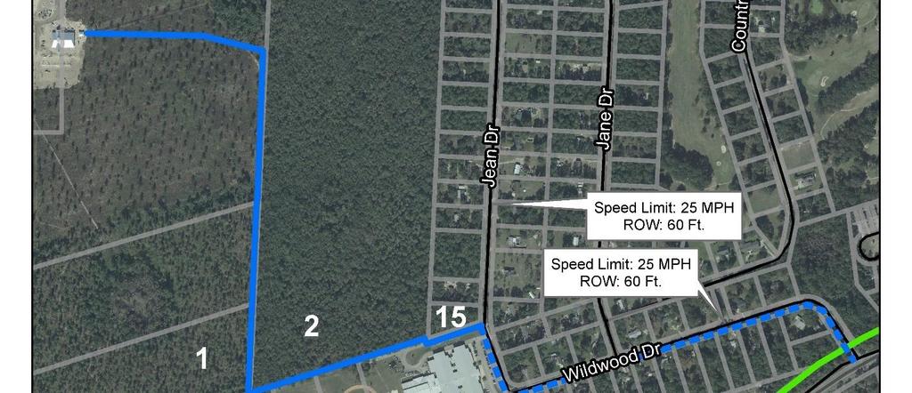
13 Trail Alternative Descriptions Trail Alternative A Alternative A makes use of the existing WEI property, beginning at the eastern trailhead facility and heading south through the WEI owned property and continuing either through the adjacent private property south of the WEI or east of WEI. The property owner to the south, (1) has expressed a willingness to allow construction of the trail along the eastern border of their parcel. From this point, Alternative A may cross south into another owner s (2) property to make the connection with the northwestern corner of the Wakulla Middle School property (4-6). The Alternative will run east along the northern border of the school property until it reaches Jean Dr. At this location, the trail will transition from a shared-use path to shared lane markings running south along Jean Dr. onto Wildwood Dr. The alternative will follow Wildwood Dr. until it makes the connection with U.S. 98 and the Coastal Trail. Figure 6 depicts Alternative A s route to the Coastal Trail. Additionally, this alternative also has the option to be placed within the property (2) east of the WEI property. Photo 4: Northern Boundary of Wakulla Middle School This alternative will allow for effective travel between the neighborhoods and nearby Wakulla Middle School while also increasing access to the WEI. The increased access to the middle school may promote the development of shared learning experiences and/or field trip opportunities being developed at the WEI. By connecting the Coastal Trail to the WEI, the alternative will help create a safe and effective east/west trail that provides an additional connection between Crawfordville Highway and U.S. 98. This route will provide additional transportation options to students located along Crawfordville Highway, who might not have a safe pedestrian route to school. Table 1 identifies known benefits and challenges with this route. Table 1: Alternative A Benefits and Challenges Alternative A Benefits Primarily within existing road ROW/public property A private owner has expressed interest in an access easement or limited acquisition Increased connectivity between the middle school and WEI Challenges Limited space on middle school property may require additional properties to be impacted Security fencing will be required to separate the trail from Wakulla Middle School Trail may impact 5 parcels Page 11 of 29
14 Figure 6: Alternative A Route Page 12 of 29
15 Trail Alternative B: Alternative B begins at the trailhead location on the eastern edge of the WEI complex and continues east through the property directly adjacent which is privately owned (2). Bisecting the private property through an easement, the alternative gains direct access to Jean Dr. Once on Jean Dr., the alternative will head south onto Wildwood Dr. to make the connection with U.S. 98 and the Coastal Trail. Figure 7 depicts Alternative B s route to the Coastal Trail. Alternative B will be shared use path from the WEI to Jean Dr., where it will transition to a shared lane markings until its connection with U.S. 98. This trail alternative will increase access between the WEI, the neighborhood, and Wakulla Middle School. Like Alternative A, the increased access to the WEI may improve the education opportunities with the middle school while also increasing the ability of the students to travel safely through the area and between the neighborhoods. This alternative will have the most significant benefit to the homes along Jean Dr. by providing access to the northern area of the existing neighborhood and becoming a potential amenity for nearby undeveloped parcels. A list of known benefits and challenges can be seen in Table 2. Table 2: Alternative B Benefits and Challenges Alternative B Benefits Impacts one private parcel Increases access to the middle school without directly impacting its property Challenges Bisects privately owned parcel and may impact the parcel owner s access to Jean Dr. ROW/easement purchase will likely be necessary Page 13 of 29

16 Figure 7: Alternative B Page 14 of 29
17 Trail Alternative C Alternative C begins by following Alternative A s route through the WEI and private parcels (1) to the south. Once at the southern boundary of the private parcel (1), the trail will continue west until it reaches an unpaved private road under the same ownership (7). This private road will be followed until the trail reaches Wildcat Alley, another unpaved private road with several owners (8-10). The proposed trail will continue until it reaches Casora Dr., where it will turn south onto Sonja Lynn St. The trail will then travel into the Medart Recreation Park property (11-14). Alternative C plans to travel along the perimeter of the recreation park heading toward Evalinda St. At Evalinda St. the trail will make the connection to U.S. 98 and the Coastal Trail. Figure 8 depicts Alternative C s route to the Coastal Trail. This trail alternative will provide increased access to the areas south of the WEI and provide an improved connection with the Medart Recreation Park. Sections of the alternative will run through private and unpaved roads which may require the installation of wayfinding signs or even paving the roadways to improve trail conditions. In lieu of wayfinding signs, Wakulla County and CRTPA may consider negotiating with the property owners to pave the private roads, which could allow for the use of shared lane markings. In addition to the challenges created by the unpaved roads, Sonja Lynn St. is surrounded by wetlands which could pose concerns for flooding. To increase the impact of Alternative C, a small trail spur may be considered near Property 15 to provide a connection to Wakulla Middle School. This trail spur could greatly improve the use of the trail as it would connect the WEI, Wakulla Middle School, Medart Recreation Park, and the Coastal Trail. Though Alternative C is the longest of the proposed routes, the potential to connect these features represents a significant benefit to the community. Known benefits and challenges of the alternative being depicted can been seen in Table3. Table 3: Alternative C Benefits and Challenges Alternative C Benefits Connects the Medart Recreation Park with the WEI Connection to the middle school may be a possibility (via trail spur) Provides connections to the neighborhoods south of the WEI Challenges Sonja Lynn Street is surrounded by a wetland Wild Cat Alley is an unpaved private roadway Longest alternative May impact 9 parcels Page 15 of 29
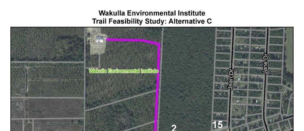
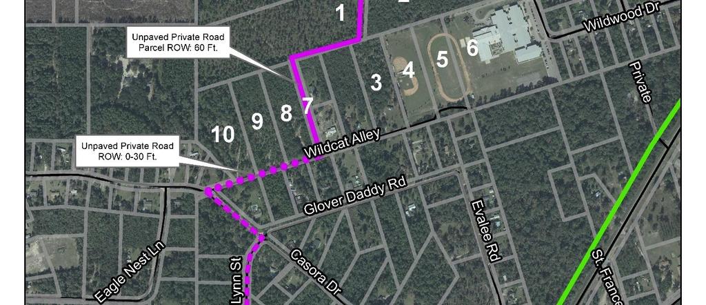
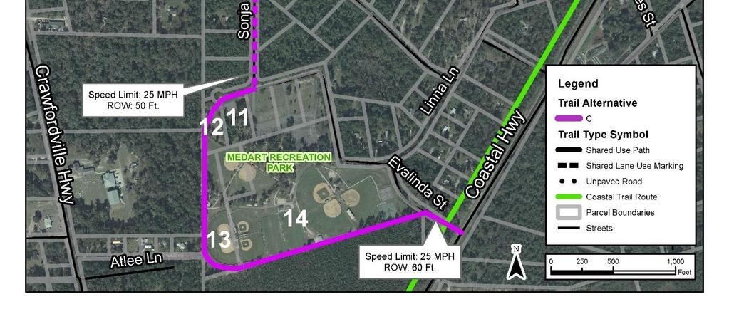
18 Figure 8: Alternative C Route Page 16 of 29
19 Future Residential Development During this feasibility study, the parcel directly east of the WEI property was purchased by a local developer with the intentions of constructing a single family residential development. The project team met with the developer to discuss general coordination with the proposed trail. The developer stated that a road that connects this residential development over to U.S. 319 is desirable. The possible road route would be along the property boundary of this residential development, through the south perimeter of the Gaby property, then along the existing, unpaved road easement owned by Gaby to Wildcat Alley to Casora Drive and out to U.S. 319 (Figure 9). If this route was ever constructed, a shared use path (or shared lane marking) could be placed adjacent to the roadway for access to the WEI as well as the residential development. This opportunity may be furthered considered as comprehensive plan changes for this parcel occur and construction of the road is further evaluated. Page 17 of 29

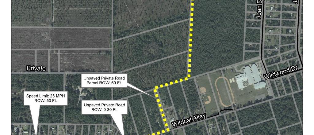
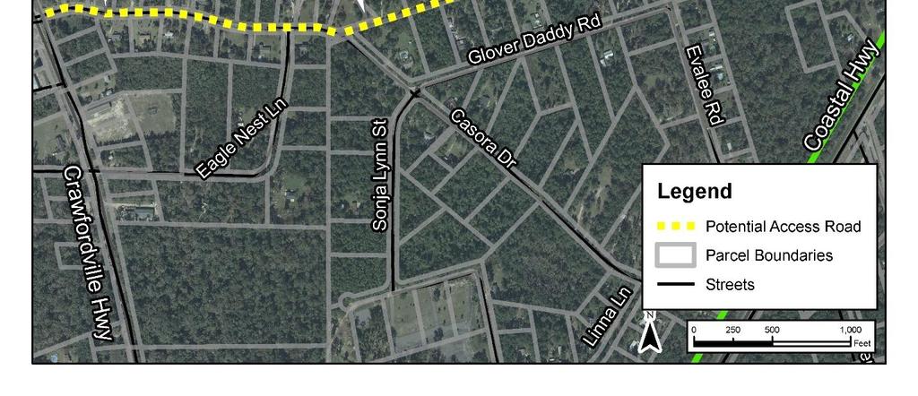
20 Figure 9: Potential Development U.S. 319 Access Road Page 18 of 29
21 Potential Costs Using the proposed routes above, approximate costs have been developed detailing the trail distances and types. For these alternatives, three trail cost types have been considered. These types have been outlined in Table 4. Trail Type Table 4: Trail Type Costs Per Mile Approximate Cost (Per Mile) Road Paving* $ 2,200, Shared Lane Markings $ 30, Shared Use Path** $ 570, *FDOT LRE (2 lane 5 ft. shoulder) ** FDOT Actual Adjusted ($450,000 + PE: $60,000 + CEI: $60,000) The distances that the proposed alignments will vary between shared use paths and shared lane markings in each of the alternatives have been outlined in Table 5. Table 5: Trail Type Distances Alternative Trail Type Approximate Distance (feet) Trail Alternative A Trail Alternative B Trail Alternative C Approximate Cost Shared Use Path 4,550 $ 491, Shared Lane Marking 2,760 $ 15, Shared Use Path 2,790 $ 301,193,.18 Shared Lane Marking 4,840 $ 27, Shared Use Path 8,220 $ 887, Shared Lane Marking 1,910 $ 10, Road Paving 1,000 $ 416, Approximate Total Cost $ 506, $ 328, $ 1,314, Based on the costs in Table 5, Alternative B will be the least expensive, while Alternative C represents the most expensive of the proposed routes. However, it should be noted that a part of Alternative C includes a road paving project that may be completed using funds outside of the anticipated trail funding. For example, Small County Outreach Program funding may be used. In addition, the local neighborhood would significantly benefit from this type of project, so for these reasons a portion of these costs will not be considered in the alternatives comparison. Typical Sections Typical section renderings have been created to depict the potential arrangement of the proposed alternatives in the area. These typical sections show how the shared-use paths and shared lane markings may be implemented through the different alternatives. Page 19 of 29
22 Figures 10 and 11 depict the how the implementation of shared lane markings could be implemented on the roadways. Shared lane markings represent the least amount of impact to the existing road network with relatively low cost. Shared lane markings should only be implemented on low volume roadways with speeds at or below 35 mph. Figures 12 to 14 depict how a paved trail could be implemented through the wooded areas, Wakulla Middle School, and the Medart Recreation Park near the WEI. Where feasible, ft. paved trails should be implemented to accommodate larger user volumes and types. Figure 15 depicts the ideal development of the trail alongside the roadway. When feasible, the creation of a shared use path alongside the road should be implemented in order to provide a safer and more enjoyable trail system. In areas with low speeds and limited right of way, the trail can be placed directly alongside the travel lanes with a vertical delineator or similar buffer to clearly designate the separation of uses. Page 20 of 29


23 Figure 10: Shared-Lane Marking Typical Section Page 21 of 29


24 Figure 11: Shared-Lane Marking Typical Section Page 22 of 29

25 Figure 12: Shared-Use Path Typical Section Page 23 of 29


26 Figure 13: Shared-Use Path Typical Section Page 24 of 29


27 Figure 14: Shared-Use Path Typical Section Page 25 of 29


28 Figure 15: Shared-Use Path Adjacent to Roadway Page 26 of 29


29 Wayfinding and Signage To help orient people better to this WEI trail connection, a unique symbol of a turkey may be used for the shared lane markings and wayfinding signage. This is a symbol used by the WEI and one that can easily recognizable so visitors to the area know what part of the regional trail system they are on. Figure 16 and Figure 17 show examples of potential shared lane markings and trail signage. Figure 16: Wayfinding Options Figure 17: Wayfinding Options Page 27 of 29
30 Preferred Alternative Based on meetings with stakeholders, desktop review of existing conditions, and new development plans on adjacent properties, there are two viable options for this trail connection. Alternative C is viable through the potential road construction from the property east of the WEI. With the possible construction of a road through that property which is planned to be developed, then going through property 1 and property 7, the WEI trail would have an opportunity to be designed and constructed during that road construction. From that location, the trail would transition into shared lane markings along the neighborhood roads until reaching the Coastal Trail by way of Sonja Lynn St. This alternative would also give direct trail access to the new residential development in property 2. If it is determined that this property is not developable or that the new road is not feasible, placing the trail along the edge of this property, through the property owned by the Wakulla County School Board, Alternative A, would be another viable option. This alternative will require the construction of a security fence and ongoing coordination with the Wakulla County School Board on their lease of the property north of the middle school. Both preferred alignments would need easements on private land but property would not need to be purchased. Possible acquisition of property is also a possibility for these alternatives. With the possibility of the road design, construction, and paving being completed for the residential development, the estimated cost to implement the trail may be minimized. Table 6 below summarizes the two viable options. Viable Option Approximate Total Cost Table 6: Trail Type Distances Modified Approximate Total Cost* Property Acquisition Number of Easements Trail Alternative A $ 506, $ 506, No 1 plus private road easement Trail Alternative C $ 1,314, $898, No 2 *Based on removing the cost of road pavement if already completed for the development of the new road connecting to Parcel 2. Next Steps The National Environmental Policy Act requires that all transportation projects complete an environmental assessment to determine the most appropriate alternative and environmental effects. Environmental refers to the natural environment, physical environment, and human environment. The type of environmental assessment is based on who is preparing the document, funding for the project, and preliminary analysis. Based on initial desktop analysis, it is anticipated that a minor environmental document will be required for this trail project, but that is dependent on whether or not it will be constructed along with the possible new road corridor. Coordination with appropriate agencies will need to take place during this stage of the project. The environmental assessment will look at the preferred alignment and make appropriate modifications to that alignment to reduce environmental impacts. Once the environmental document is approved, the project will move into design and construction. Page 28 of 29
31 Conclusion The cost estimates found in this feasibility report are based on planning level cost estimates including costs for CEI and construction. The range of total costs for the viable alternatives found in this study are between $500,000 and $900,000 approximately. As stated above, if development occurs and the trail can be designed and constructed along with other projects, the cost to implement may be reduced as seen in the table above. The final trail alignment will be determined through near term coordination with private property owners, Wakulla County, and the Wakulla County School Board. Page 29 of 29
Longmont to Boulder Regional Trail Jay Road Connection DRAFT FINAL REPORT
 Longmont to Boulder Regional Trail Jay Road Connection DRAFT FINAL REPORT December 2018 Project Summary Boulder County, Colorado, in partnership with the City of Boulder, is evaluating options for multi-use
Georgetown-Lewes Rail/Trail Study. Rail/Trail Study: Cool Spring to Cape Henlopen State Park New Road Extension (House Resolution No.
 Georgetown-Lewes Rail/Trail Study Rail/Trail Study: Cool Spring to Cape Henlopen State Park New Road Extension (House Resolution No. 47) August 22, 2011 Presentation Outline Background Benefits Statewide
APPENDIX OFFICIAL MAP ORDINANCE OF HAMILTONBAN TOWNSHIP OFFICIAL MAP NARRATIVE
 APPENDIX A OFFICIAL MAP ORDINANCE OF HAMILTONBAN TOWNSHIP OFFICIAL MAP NARRATIVE INTRODUCTION: The Official Map of Hamiltonban Township has been prepared to identify those lands and features that Hamiltonban
Business Item No
 Metropolitan Parks and Open Space Commission Meeting date: February 6, 2018 For the Community Development Committee meeting of February 20, 2018 For the Metropolitan Council meeting of February 28, 2018
Tallahassee-St. Marks Historic Railroad Trail
 Revitalizing a Historic Trail Designated as a National Recreation Trail, the 16-mile Tallahassee-St. Marks Historic Railroad Trail has been enjoyed by countless bicyclists, runners, and outdoor enthusiasts
CHAPTER 5. Chapter 5 Recreation Element
 CHAPTER 5 Recreation Element Chapter 5 Recreation Element The Recreation Element of the Meyers Area Plan is a supplement to the Recreation Element of the TRPA Regional Plan and the El Dorado County General
Chapter 6: POLICY AND PROCEDURE RECOMMENDATIONS
 Chapter 6 POLICY AND PROCEDURE RECOMMENDATIONS FOR SRRA Below are seven policy elements that should be considered for adoption by the Southwest Regional Recreation Authority of Virginia: 1. Develop strategies
Lake Erie Commerce Center Traffic Analysis
 LOCATION: East of NYS Route 5 at Bayview Road Town of Hamburg Erie County, New York PREPARED BY: Wendel Companies 140 John James Audubon Parkway Suite 200 Amherst, New York 14228 January 2012 i ii Table
Blueways: Rivers, lakes, or streams with public access for recreation that includes fishing, nature observation, and opportunities for boating.
 Parks, Open Space and Trails PRINCE WILLIAM COUNTY 2008 COMPREHENSIVE PLAN TRAILS PLAN CONTENTS The components of the trails plan are: Intent Definitions Goals, Policies, and Action Strategies Trails Map
The Baker/Carver Regional Trail is intended to
 Section V Design Guidance The Baker/Carver Regional Trail is intended to safely accommodate 183,000 annual visits, an array of non-motorized uses, a variety of skill levels, and persons with special needs.
Committee Report. Community Development Committee For the Metropolitan Council meeting of April 13, Business Item No.
 Committee Report Business Item No. 2016-48 Community Development Committee For the Metropolitan Council meeting of April 13, 2016 Subject: Harriet Island-South St. Paul Regional Trail Master Plan, Saint
PURPOSE AND NEED (CONCURRENCE POINT 1) NEW CANADA ROAD PROJECT FROM STATE ROUTE 1 (U.S. HIGHWAY 70) TO U.S. INTERSTATE 40
 NEW CANADA ROAD PROJECT FROM STATE ROUTE 1 (U.S. HIGHWAY 70) TO U.S. INTERSTATE 40") PURPOSE AND NEED (CONCURRENCE POINT 1) NEW CANADA ROAD PROJECT FROM STATE ROUTE 1 (U.S. HIGHWAY 70) TO U.S. INTERSTATE 40 Project Description The primary purpose of this project is to improve the major
PURPOSE AND NEED (CONCURRENCE POINT 1) NEW CANADA ROAD PROJECT FROM STATE ROUTE 1 (U.S. HIGHWAY 70) TO U.S. INTERSTATE 40 Project Description The primary purpose of this project is to improve the major
Chapter 4.0 Alternatives Analysis
 Chapter 4.0 Alternatives Analysis Chapter 1 accumulated the baseline of existing airport data, Chapter 2 presented the outlook for the future in terms of operational activity, Chapter 3 defined the facilities
Other Principle Arterials Minor Arterial Major Collector Minor Collector Local
 CHAPTER 10 TRANSPORTATION Introduction The system of public roads in East Pikeland Township is decidedly rural in character. Since the 1984, the road network has remained much the same, with the addition
Trail Feasibility Study
 VOLUSIA COUNTY MPO CITY OF NEW SMYRNA BEACH FINAL REPORT JUNE 30, 2009 Trail Feasibility Study What s inside? 1 Introduction 2 Project Purpose & Scope 3 Physical Inventory & Assessment of Right-of- Way
Regional Wayfinding Sign Strategy Thurston County Trails 2017
 Regional Wayfinding Sign Strategy Thurston County Trails 2017 Partners: Members and partnering organizations of the Thurston Thrives Community Design Action Team City of Lacey, City of Olympia, City of
Business Item No XXX. Proposed Action That the Metropolitan Council approve the Coon Creek Regional Trail Master Plan.
 Business Item No. 2015-XXX Metropolitan Parks and Open Space Commission Meeting date: July 7, 2015 For the Community Development Committee meeting of July 20, 2015 For the Metropolitan Council meeting
FEASIBILITY STUDY. holdings SEPTEMBER 13, prepared for: prepared by:
 FEASIBILITY STUDY SEPTEMBER 13, 2013 prepared for: holdings prepared by: Table of Contents Project Feasibility... 3 Project Background... 4 Project and Community Context... 5 Site constraints... 6 Statement
East Link Project Update. Maintenance of Traffic During Construction. April 21, 2015
 East Link Project Update Maintenance of Traffic During Construction April 21, 2015 1 Agenda TFP project 242 Bellevue Way HOV Bellevue Way - Maintenance of Traffic During Construction Early Work Utilities
SOUTH INTERCHANGE AREA
 Santaquin City General Plan 1 Location and Characteristics The South Interchange Area of Santaquin is located west of Interstate 15 and south of 500 South (Figure 1). It includes properties already annexed
Welcome to the Cross County Trail Public Input Session!
 Welcome to the Cross County Trail Public Input Session! Please sign in on the table below! What are we doing here? Camden County has proposed a bicycle and pedestrian trail spanning across the entire county.
Parkland County Municipal Development Plan Amendment Acheson Industrial Area Structure Plan
 Parkland County Municipal Development Plan Amendment Acheson Industrial Area Structure Plan New Plan Acheson Industrial Area Structure Plan Amendment Parkland County Municipal Development Plan Board Reference
Wallace Falls State Park Classification and Management Planning Stage 3 Preliminary Recommendations July 18, 2018 Sultan City Hall
 Wallace Falls State Park Classification and Management Planning Stage 3 Preliminary Recommendations July 18, 2018 Sultan City Hall Thanks for coming! This document contains State Parks preliminary recommendations
Auburn Trail / Ontario Pathways Trail Connector Feasibility Study Public Information Meeting Wednesday, August 22, 2012
 Auburn Trail / Ontario Pathways Trail Connector Feasibility Study Public Information Meeting Wednesday, August 22, 2012 Purpose of Feasibility Study Purpose Evaluate the feasibility of constructing a multiuse
Appendix 3. Greenway Design Standards. The Whitemarsh Township Greenway Plan
 Appendix 3 Greenway Design Standards This chapter discusses two design standards for the greenway types discussed above. First, trail design standards are presented together with trailhead facilities and
Gardner: overview. Santa Fe, Oregon, and California National Historic Trails UNINCORPORATED JOHNSON COUNTY OLATHE UNINCORPORATED JOHNSON COUNTY
 Santa Fe, Oregon, and California ational Historic Trails : overview 99: p.134 100: p.135 GARDER JUCTIO 102: p.137 56: p.126 EDGERTO Burlington orthern Intermodal and Logistics 98: p.133 101: p.136 S Waverly
The Chu property is a 6.57 acre parcel located in the Town of Superior on the west side of McCaslin Boulevard. In 2014, the Town of Superior acquired
 1 The Chu property is a 6.57 acre parcel located in the Town of Superior on the west side of McCaslin Boulevard. In 2014, the Town of Superior acquired the Chu property for open space with a contribution
Cascade River State Park Management Plan Amendment
 This document is made available electronically by the Minnesota Legislative Reference Library as part of an ongoing digital archiving project. http://www.leg.state.mn.us/lrl/lrl.asp Cascade River State
Community Development Committee
 C Community Development Committee For the Metropolitan Council meeting of October 31, 2012 Committee Report Item:2012-316 ADVISORY INFORMATION October 16, 2012 Date Prepared: Subject: Intercity Regional
4.19 Parks, Recreation, and Conservation Lands
 interchange would have on the Reed Paige Clark Homestead located on the north side of Stonehenge Road. Alternative D would also affect Palmer Homestead, E.F. Adams House, and Knapp Brothers Shoe Manufacturing
4. Safety Concerns Potential Short and Medium-Term Improvements
 NH Route 104 Access Management Study Page 19 4. Safety Concerns Potential Short and Medium-Term Improvements Potential safety improvement strategies are listed by priority based on field observations by
SUMMER VILLAGE OF SILVER SANDS. Municipal Development Plan
 SUMMER VILLAGE OF SILVER SANDS Municipal Development Plan Bylaw 253-2014 Adopted August 22, 2014 Summer Village of Silver Sands Municipal Development Plan Bylaw No. 253-2014 Page 2 1 INTRODUCTION 1.1 SETTING
A CASE FOR COMPLETING THE JORDAN RIVER PARKWAY: A
 A CASE FOR COMPLETING THE JORDAN RIVER PARKWAY: A safe crossing at 9000 South and 850 West Proposed 9000 South Underpass Parkway Timeline Parkway, Trail, and Tourism Facts Blueprint Jordan River 1971 1973
Safety, Infrastructure, and Tenant Improvement Project. Public Hearing Informational Brochure February 26, 2013
 New York State Department of Transportation Safety, Infrastructure, and Tenant Improvement Project Public Hearing Informational Brochure February 26, 2013 This DEIS/Draft EA evaluates the potential impacts
ANCLOTE COASTAL TRAIL ALTERNATIVES ANALYSIS STUDY
 ANCLOTE COASTAL TRAIL ALTERNATIVES ANALYSIS STUDY PASCO COUNTY MPO JULY 2015 PROJECT OVERVIEW... INTRODUCTION EXECUTIVE SUMMARY CONTEXT... TAMPA BAY AREA, PINELLAS, & PASCO COUNTY S MULTI-USE TRAIL PLANS
Committee Report. Community Development Committee For the Metropolitan Council meeting of August 12, Business Item No.
 Committee Report Business Item No. 2015-168 Community Development Committee For the Metropolitan Council meeting of August 12, 2015 Subject: Coon Creek Regional Trail Master Plan, Anoka County Proposed
NEWBORO AND PORTLAND HARBOUR REDVELOPMENT PLANS
 INTRODUCTION The Municipal docks in both Newboro and Portland were transferred to the Township of Rideau Lakes by Parks Canada in 2002. Little has been done to improve the docks physical condition or role
3. COLTA / HUGA CONNECTIONS - PRELIMINARY
 9 3. COLTA / HUGA CONNECTIONS - PRELIMINARY 3.1 COLTA The Chain of Lakes Trail Association (COLTA) trail, formerly identified as the Chester Spur Line, was completed and opened for use in June 2011. The
2. Goals and Policies. The following are the adopted Parks and Trails Goals for Stillwater Township:
 D. PARKS AND TRAILS 1. Introduction Stillwater Township s population is relatively low, with most residents living on rural residences on large lots. The need for active park space has been minimal in
Northeast Quadrant Distinctive Features
 NORTHEAST QUADRANT Northeast Quadrant Distinctive Features LAND USE The Northeast Quadrant includes all the area within the planning area that is east of Interstate 5 and to the north of State Route 44.
Section II. Planning & Public Process Planning for the Baker/Carver Regional Trail began in 2010 as a City of Minnetrista initiative.
 Section II Planning & Public Process Planning for the began in 2010 as a City of initiative. city staff began discussions with the Park District on the possibility of a north/south regional trail connection
MASTER PLAN EXECUTIVE SUMMARY
 Biscuit Run State Park Scottsville Road (State Route 20) Charlottesville, VA 22902 Biscuit Run State Park MASTER PLAN EXECUTIVE SUMMARY Department of Conservation and Recreation Division of Planning and
C. APPROACH FOR IDENTIFYING THE BEST ROUTES FOR THE NEEDED TRANSMISSION SYSTEM IMPROVEMENTS
 C. APPROACH FOR IDENTIFYING THE BEST ROUTES FOR THE NEEDED TRANSMISSION SYSTEM IMPROVEMENTS CL&P s approach for identifying the best routes for the needed transmission system improvements included a determination
City of Durango 5.8 FUNDING TRAILS DEVELOPMENT
 5.8 FUNDING TRAILS DEVELOPMENT The City has been successful in establishing dedicated local funding sources as well as applying for grants to develop the City s trail system, having received nearly $2.4
COMMENT PERIOD INTRODUCTION
 To: Interested Persons From: Tom Buford File: Del Rio Trail Project Date: June 8, 2018 Community Development Department Reference: NOTICE OF PREPARATION OF AN ENVIRONMENTAL IMPACT REPORT FOR THE DEL RIO
At the time, the portion of the line through Eagle County remains wholly under the ownership of Union Pacific Railroad (UP).
.") Chapter 5 The Railroad Corridor as a Trail Corridor The intent of this chapter is to identify how the rail corridor, if available for lease or purchase in all or part, could be incorporated into the core
Chapter 5 The Railroad Corridor as a Trail Corridor The intent of this chapter is to identify how the rail corridor, if available for lease or purchase in all or part, could be incorporated into the core
ALBANY-HUDSON ELECTRIC TRAIL FEASIBILITY STUDY. Final Report OCTOBER 2011
 ALBANY-HUDSON ELECTRIC TRAIL FEASIBILITY STUDY Final Report OCTOBER 2011 ALBANY-HUDSON ELECTRIC TRAIL FEASIBILITY STUDY Prepared for: Town of East Greenbush 225 Columbia Turnpike Rensselaer, New York 12144
FEASIBILITY CRITERIA
 This chapter describes the methodology and criteria used to evaluate the feasibility of developing trails throughout the study areas. Land availability, habitat sensitivity, roadway crossings and on-street
The Recreational Trail along Cushing Park road has been a successful addition to the city
 The Recreational Trail along Cushing Park road has been a successful addition to the city Trails TRAILS, PATHS, ROUTES AND CONNECTORS Citizen input pointed to trails, paths, bike routes, and other non-motorized
Becker County Trail Routing Feasibility Study
 2016 Becker County Trail Routing Feasibility Study CONNECTING DETROIT MOUNTAIN AND MOUNTAIN VIEW RECREATIONAL AREA TO THE HEARTLAND TRAIL BECKER COUNTY ULTEIG ENGINEERS Contents Acknowledgements...2 INTRODUCTION...3
STAFF REPORT. Airport Land Use Plan Consistency Review: Santa Barbara Airport Master Plan. MEETING DATE: November 19, 2015 AGENDA ITEM: 7D
 STAFF REPORT SUBJECT: Airport Land Use Plan Consistency Review: Santa Barbara Airport Master Plan MEETING DATE: AGENDA ITEM: 7D STAFF CONTACT: Peter Imhof, Andrew Orfila RECOMMENDATION: Adopt findings
City of Solvang SUNNY FIELDS SPUR TRAIL STUDY
 City of Solvang SUNNY FIELDS SPUR TRAIL STUDY project description The City of Solvang, in partnership with the County of Santa Barbara Public Works Department, is developing an alignment study for a proposed
THOMAS A. SWIFT METROPARK Introductions History Present Conditions Future Development Plans Implementation Strategies Statistics
 THOMAS A. SWIFT METROPARK Introductions History Present Conditions Future Development Plans Implementation Strategies Statistics Introduction As an open meadow park positioned along the Mahoning River,
Great Wolf Lodge Fact Sheet & Frequently Asked Questions Potential Location in Gilroy, California 8/30/17
 WHAT? Great Wolf Resorts has identified Gilroy, California as a potential location for a new Great Wolf Lodge family resort and has entered into a 60-day period of exclusivity with the City and community
chapter - Hex Highway Touring Route Hamburg to Strausstown Overview
 chapter - 2 Hex Highway Touring Route Hamburg to Strausstown Overview The on-road Hex Highway automobile and bicycle touring route begins on State Street in downtown Hamburg. The route continues west on
Macleod Trail Corridor Study. Welcome. Macleod Trail Corridor Study Open House. Presentation of Proposed Design Concepts
 Macleod Trail Corridor Study Welcome Macleod Trail Corridor Study Open House Presentation of Proposed Design Concepts Study Purpose Develop a corridor plan for Macleod Trail that aligns with The City s:
PLANNING COMMISSION AGENDA REPORT May 10, Members of the Planning Commission. Joyce Parker-Bozylinski, Contract Planner
 PLANNING COMMISSION AGENDA REPORT May 10, 2007 TO: FROM: PROPOSAL: APPLICANT: RECOMMENDATION: Members of the Planning Commission Joyce Parker-Bozylinski, Contract Planner Approval of the Calabasas Trails
US 380 FEASIBILITY STUDY
 US 380 FEASIBILITY STUDY Denton County CSJ(s): 0135-10-061, 0135-10-062 Public Meeting(s): January 15 & 22, 2019 WELCOME US 380 Denton County Feasibility Study DALLAS DISTRICT PUBLIC MEETING January 15
Blue River Trail Master Plan JSA to Town Hall June 2004
 Blue River Trail Master Plan JSA to Town Hall June 2004 Prepared for: Silverthorne Town Council Silverthorne SPORT Committee Department of Recreation and Culture Silverthorne Public Works Silverthorne
ARLINGTON COUNTY, VIRGINIA
 ARLINGTON COUNTY, VIRGINIA County Board Agenda Item Meeting of April 16, 2005 DATE: March 28, 2005 SUBJECTS: A. Adoption of the Fort Myer Heights North Plan. B. GP-300-04-1 Adoption of the following General
FINAL. Bicycle/Pedestrian Feasibility Study City of DeBary Dirksen Drive Trail. Prepared For: Volusia County MPO
 City of DeBary Dirksen Drive Trail FINAL Prepared By: Reynolds, Smith and Hills, Inc. Prepared For: Volusia County MPO September 2007 Table of Contents INTRODUCTION...1 PROJECT PURPOSE AND SCOPE...2 PHYSICAL
EXECUTIVE SUMMARY FALL Introduction. Findings
 EXECUTIVE SUMMARY FALL 2004 Introduction Trails are one of the most popular and highly desirable recreational resources in communities of all sizes throughout the country. In addition to providing a safe
CHAPTER ONE LITERATURE REVIEW
 CHAPTER ONE LITERATURE REVIEW LITERATURE REVIEW This chapter summarizes the most recently published community impact studies and articles that relate to multiuse trails. The review focuses on publications
SR 934 Project Development And Environment (PD&E) Study
 Study") SR 934 Project Development And Environment (PD&E) Study Project Advisory Group Meeting March 1, 2018 State Road 934/NE/NW 79th Street from west of I-95 (NW 13th CT) to N. Bayshore Drive PD&E STUDY SR 934/NE/NW
SR 934 Project Development And Environment (PD&E) Study Project Advisory Group Meeting March 1, 2018 State Road 934/NE/NW 79th Street from west of I-95 (NW 13th CT) to N. Bayshore Drive PD&E STUDY SR 934/NE/NW
2016 Regional Transportation Alternatives Program (TAP) Grant Application
 Grant Application") 2016 Regional Transportation Alternatives Program (TAP) Grant Application PROJECT TITLE: Yelm-Tenino Trail Extension Feasibility Study TRPC use only GENERAL PROJECT INFORMATION Agency or Organization City
2016 Regional Transportation Alternatives Program (TAP) Grant Application PROJECT TITLE: Yelm-Tenino Trail Extension Feasibility Study TRPC use only GENERAL PROJECT INFORMATION Agency or Organization City
CHAPTER 4 -- THE LAND USE PLAN: DESCRIPTIONS AND POLICIES FOR THIRTEEN PLANNING AREAS
 CHAPTER 4 -- THE LAND USE PLAN: DESCRIPTIONS AND POLICIES FOR THIRTEEN PLANNING AREAS NORTH CENTRAL CAC AREA LITTLE VALLEY ROAD TO JUG HANDLE CREEK PLANNING AREA This planning area includes Cleone, Noyo,
SECTION 5 ALTERNATIVE DEVELOPMENT CONCEPT ANALYSES
 SECTION 5 ALTERNATIVE DEVELOPMENT CONCEPT ANALYSES 5.1 INTRODUCTION This section investigates Airfield Development Alternatives, generalized Land Use Alternatives, and more detailed General Aviation Alternatives.
METROPOLITAN COUNCIL 390 North Robert Street, St. Paul, MN Phone (651) TDD (651)
 TDD (651)") METROPOLITAN COUNCIL 390 North Robert Street, St. Paul, MN 55101 Phone (651) 602 1000 TDD (651) 291 0904 DATE: June 19, 2007 TO: Metropolitan Parks and Open Space Commission FROM: Jan Youngquist, Senior
METROPOLITAN COUNCIL 390 North Robert Street, St. Paul, MN 55101 Phone (651) 602 1000 TDD (651) 291 0904 DATE: June 19, 2007 TO: Metropolitan Parks and Open Space Commission FROM: Jan Youngquist, Senior
Welcome to the Illinois High-Speed Rail Chicago to St. Louis Construction Update Meeting. Today s meeting will provide an overview of the Program,
 Welcome to the Illinois High-Speed Rail Chicago to St. Louis Construction Update Meeting. Today s meeting will provide an overview of the Program, updates on construction to be held in this area, and how
CHAPTER 6 NOISE EXPOSURE
 CHAPTER 6 NOISE EXPOSURE FAA requires that the NEM submitted for review represent the aircraft noise exposure for the year of submittal (in this case 2008) and for a future year (2013 for OSUA). However,
Airport Planning Area
 PLANNING AREA POLICIES l AIRPORT Airport Planning Area LOCATION AND CONTEXT The Airport Planning Area ( Airport area ) is a key part of Boise s economy and transportation network; it features a multi-purpose
Economic Development and Tourism
 SECTION 4 SECTION 4 Economic Development and Tourism 4. Economic Development and Tourism Tourism plays a very important role in Niagara s economy, providing employment and generating business for support
Committee. Presentation Outline
 CW-33-15 11/9/2015 Community and Corporate Services Committee November 10, 2015 1 Presentation Outline Background Vision and Objectives Study Process and Timeline Public and Stakeholder Engagement Organization
White Mountain National Forest Saco Ranger District
 United States Department of Agriculture Forest Service White Mountain National Forest Saco Ranger District 33 Kancamagus Highway Conway, NH 03818 Comm: (603) 447-5448 TTY: (603) 447-3121 File Code: 1950
Agenda: SASP SAC Meeting 3
 Agenda: SASP SAC Meeting 3 Date: 04/12/18 Public Involvement Plan Update Defining the System Recommended Classifications Discussion Break Review current system Outreach what we heard Proposed changes Classification
Grove Field Airport Environmental Assessment
 Grove Field Airport Environmental Assessment Advisory Committee Meeting #2 December 9, 2008 Port of Camas-Washougal Conference Room 6:00 7:30 PM Agenda: Welcome and Overview Dave Ripp, Director, Port of
MORGAN CREEK GREENWAY Final Report APPENDICES
 APPENDICES MORGAN CREEK GREENWAY Appendix A Photos of Existing Conditions in Trail Corridor Photos of existing conditions Main trail corridor - February 2009 Photos of existing conditions south bank Morgan
Trail # NW Tuesday, June DESIGN. Provide an Review the Provide an. Project Goals: System system. wayfinding
 I. Welcome / Introductions Bethany Creek Trail #2 Segment 3 Neighborhood Meeting #1 Bethany Presbyterian Church 15505 NW Springville Road, Portland, OR 97229 Tuesday, June 26, 2018 @ 6:00PM Meeting Minutes
Port Gamble Shoreline Area Conceptual Trail Proposal
 The North Kitsap Trails Association is pleased to be a partner to the Kitsap Forest and Bay Project and assist Kitsap County, Forterra, Olympic Property Group, Great Peninsula Conservancy and the Port
D1 January 8, 2014 Public Hearing APPLICANT: HUNT CLUB FARM
 D1 January 8, 2014 Public Hearing APPLICANT: HUNT CLUB FARM PROPERTY OWNER: HUNT CLUB A-1- A, LLC. STAFF PLANNER: Kevin Kemp REQUEST: Modification of a Conditional Use Permit approved by the City Council
Business Item No xx
 Business Item No. 2015-xx Metropolitan Parks and Open Space Commission Meeting date: April 7, 2015 For the Community Development Committee meeting of April 21, 2015 For the Metropolitan Council meeting
Washington Township MASTER PLAN. Addendum: Washington Township Master Plan
 Washington Township MASTER PLAN Addendum: Washington Township Master Plan CHAPTER XI RECREATION CORE DISTRICT Introduction The Recreation Core District generally encompasses the areas north of 30 Mile
Dungeness Recreation Area County Park Master Plan
 Dungeness Recreation Area County Park Public Outreach Meeting October 10, 2007 Project Overview USFWS Site Dungeness Recreation Area County Park Meeting Objectives: Re-Introduce project; provide status
Lake Tahoe Airport Master Plan Public Meeting March 16, 2015
 Lake Tahoe Airport Master Plan Public Meeting March 16, 2015 What is an Airport Master Plan? a comprehensive study of an airport [that] usually describes the short, medium, and long term development plans
Snowmobile Connectors Are Disconnected
 Snowmobile Connectors Are Disconnected By Dave Gibson Adirondack Explorer MONDAY, AUGUST 10, 2015 The Boreas River and Route 28N where DEC proposes a new snowmobile bridge. Photo c Dave Gibson The contradictory,
Figure San Dimas Bonita at San Dimas Avenue (view looking west)
") The adjoining neighborhood has an eclectic assortment of building types and uses, including: the historically significant but not architecturally or visually noteworthy San Dimas Lemon Association Packing
The adjoining neighborhood has an eclectic assortment of building types and uses, including: the historically significant but not architecturally or visually noteworthy San Dimas Lemon Association Packing
Rule Governing the Designation and Establishment of All-Terrain Vehicle Use Trails on State Land
 Rule Governing the Designation and Establishment of All-Terrain Vehicle Use Trails on State Land 1.0 Authority 1.1 This rule is promulgated pursuant to 23 V.S.A. 3506. Section 3506 (b)(4) states that an
MUNICIPALITY OF ANCHORAGE
 DATE: June 3, 2009 MUNICIPALITY OF ANCHORAGE PARKS & RECREATION DEPARTMENT MEMORANDUM PRC #09-35 TO: FROM: SUBJECT: Parks and Recreation Commission Tom Korosei, Park Planner Proposed Land Exchange for
Northaven Trail Phase 2 Initial Project Overview
 Northaven Trail Phase 2 Initial Project Overview Partnership Project to extend existing Northaven Trail Improve Bike/Ped Connectivity On Dallas Trail Network Plan City and County Funding Oncor Texas Trails
Chatsworth Branch Library Devonshire Street, Chatsworth, CA Thursday, November 16, :00-8:00 pm
 Chatsworth Branch Library 21052 Devonshire Street, Chatsworth, CA 91311 Thursday, November 16, 2017 6:00-8:00 pm Project Team County of Los Angeles Department of Parks and Recreation Kathline King Chief
CHAPTER 3 ALTERNATIVES CONSIDERED
 CHAPTER 3 ALTERNATIVES CONSIDERED 3.0 ALTERNATIVES The 2010 Stevensville Airport Master Plan contained five (5) airside development options designed to meet projected demands. Each of the options from
Rogue River Access and Management Plan Draft Alternatives
 Rogue River Access and Management Plan Draft Alternatives The Rogue River Access and Management Plan was initiated in December, 2011 and is being led by Jackson County Parks (JCP) and Oregon Department
TRANSPORTATION ELEMENT
 Transportation TRANSPORTATION ELEMENT Data, Inventory, and Analysis Prepared by Contents 1.0 INTRODUCTION... 1 2.0 EXISTING CONDITIONS... 1 2.1 Roadways... 1 2.1.1 Jurisdiction... 1 2.1.2 Functional Classification...
A number of goals were identified during the initial work on this Big Lake Transportation Plan.
 C. Transportation General Background Information Big Lake s transportation system includes all the roads, paths and facilities that allow the movement of private vehicles, trains and planes, as well as
Rural Rustic Road Program
 Virginia Department of Transportation s Rural Rustic Road Program Prepared by the Local Assistance Division Virginia Department of Transportation 1401 East Broad Street Richmond, Virginia 23219 Michael
Coast to Coast Connector Summit
 Project Partners Welcome to the Coast to Coast Connector Summit Winter Garden, Florida City Hall October 1, 2014 1 Why are we here? Objectives 1. Inform key stakeholders on the current state of the C2C
Assessing Your Trails, Keeping Them Safe and Enjoyable
 Jon Wood, PLA, ASLA Associate Vice President Stewart Bert Lynn, PLA, ASLA, LEED AP Project Manager Mecklenburg County Asset and Facility Management Assessing Your Trails, Keeping Them Safe and Enjoyable
Stevenson Ranch Library The Old Road, Stevenson Ranch, CA Thursday, November 9, :00-8:00 pm
 Stevenson Ranch Library 25950 The Old Road, Stevenson Ranch, CA 91381 Thursday, November 9, 2017 6:00-8:00 pm Project Team County of Los Angeles Department of Parks and Recreation Kathline King Chief of
2008 DEKALB COUNTY TRANSPORTATION PLAN (UPDATE)
") 2008 DEKALB COUNTY TRANSPORTATION PLAN (UPDATE) TABLE OF CONTENTS Introduction 1 Transportation Planning Activities 2 Identification of Problem Areas and Recommended Solutions 7 DeKalb County Projects
2008 DEKALB COUNTY TRANSPORTATION PLAN (UPDATE) TABLE OF CONTENTS Introduction 1 Transportation Planning Activities 2 Identification of Problem Areas and Recommended Solutions 7 DeKalb County Projects
DATE: 23 March, 2011 TO: Communities FROM: BlazeSports America. RE: Accessible Trails Checklist 1
 M E M O R A N D U M DATE: 23 March, 2011 TO: Communities FROM: BlazeSports America RE: Accessible Trails Checklist 1 The purpose of the Accessible Trails Checklist (below) is to help the community review