VRE Manassas Park Station Parking Expansion Alternatives Analysis
|
|
|
- Berniece Casey
- 5 years ago
- Views:
Transcription

1 VRE Manassas Park Station Parking Expansion Alternatives Analysis Summary Report September 18, 2017
2 THIS PAGE INTENTIONALLY LEFT BLANK
3 Table of Contents 1.0 Introduction Summary of Existing Conditions Parking Demand Forecast Site Assessment Selection of Preferred Parking Expansion Site Estimated Cost Funding Options Appendices... List of Figures 1 Existing VRE Manassas Station and Surface Parking City of Manassas Park Redevelopment Districts Existing Zoning in and near the Study Area Planned Developments in Manassas Park and NE Prince William Co Multimodal Access and Circulation at the VRE Manassas Park Station Avg. Daily Parking Counts for VRE Manassas Park Station (July 2013-June 2016) March 2016 Daily Parking Counts at VRE Manassas Park Station Weekday Morning Parking Fill Behavior (September 2016) VRE Manassas Park Station Slope Analysis Existing Utilities in the VRE Manassas Park Station Study Area Candidate Sites for VRE Estimated Surface Parking Area Required for 560 Spaces Existing VRE Surface Parking Lots City Hall Site Parking Structure Concept Millicent Site Parking Structure Concept Millicent and Truck Driving School Site Parking Structure Concept i
4 17 Car Repair Site Parking Structure Concept Bays Site Parking Structure Concept South Corner Site Parking Structure Concept City Center Development Concept with Candidate Garage Locations Concept for Pedestrian Bridge Connection Concept for Pedestrian Tunnel Connection Summary Evaluation Matrix for Candidate Parking Expansion Sites List of Tables 1 Existing Parking Supply at VRE Manassas Park Station Mode of Arrival for VRE Manassas Park Station Patrons VRE Manassas Park Station Forecasted Daily Boardings (2040) VRE Manassas Park Station Parking Forecast (2020, 2030, and 2040) VRE Manassas Park Station Parking Demand Forecast by Scenario Summary of Pros and Cons for Each Candidate Parking Expansion Site VRE Cost Estimate ii
5 1.0 Introduction Parking at the Virginia Railway Express (VRE) Manassas Park station is oversubscribed. The parking lot often fills up prior to the last train departing the station. With future ridership, and consequently parking demand, forecasted to increase at this station, VRE initiated a study in fall 2016 to investigate parking expansion needs and alternatives for the VRE Manassas Park station. The goal of the parking expansion study was to determine the additional number of parking spaces required, as well as to evaluate potential sites and identify a preferred site for the planned parking expansion. Other considerations included connection to a future second platform and a design that would fit with the vision for the City Center Redevelopment District, a proposed transit-accessible highdensity mixed-use town center of Manassas Park. The study included an assessment of existing conditions, environmental documentation, and analysis of locations and design alternatives for the proposed parking facility. Based on the analysis and review of candidate alternatives, including consideration of public input, VRE identified the preferred location, size, and design of the proposed parking facility, and the type of grade-separated pedestrian access to the existing platform. Throughout the process, VRE has been working closely with the City of Manassas Park and the public to gather feedback and gain consensus on the proposed parking expansion. VRE presented at the Governing Body meetings on September 6, 2016; October 18, 2016; and May 16, 2017; and also held Town Hall Meetings on November 1, 2016 and June 20, These meetings provided opportunities for the City and other stakeholders to learn about the project and provide comments on the results of each step in the process. Based on the input received during these meetings, VRE worked with City staff to address comments and as appropriate incorporate the feedback into the project. The comments provided generally included questions or suggestions related to the following topic areas: Location and size of the proposed garage Access to the garage 1
6 Architectural treatment and other design features of the garage Pedestrian access between the garage and the VRE platform Additional meetings with the Governing Body and stakeholders will occur during the next phases of the project. 2

7 2.0 Summary of Existing Conditions Land Use The VRE Manassas Park station is located at 9300 Manassas Drive in Manassas Park, Va. (Figure 1). The station is the third-to-last station on VRE s Manassas Line, which provides commuter rail service between Broad Run station in Prince William County, VA, and Union Station in Washington, D.C. The station includes a single, 710-foot long platform located on the east side of the Norfolk Southern (NS) Washington District Main Line at Milepost The station features a circular Kissand-Ride drop-off area and two surface lots and adjacent on-street parking with 616 parking spaces, including Americans with Disabilities Act (ADA) compliant parking spaces. Figure 1 Existing VRE Manassas Park Station and Surface Parking 3
8 The City of Manassas Park is largely built out, with a traditional suburban development pattern dominating. The City s land use plan recognizes that future land use and development pattern changes will likely occur through redevelopment, and identifies three districts for such activity: City Center, Conner Center, and Four Corners (Figure 2). The City Center Redevelopment District encompasses the existing VRE station and parking, extending north to Euclid Avenue. This district is envisioned to become a high-density mixed-use town center, with commercial and office uses supplemented by multi-family housing. The district, for which the VRE station is an integral component, will be designed to accommodate all transportation modes. The Conner Center Redevelopment District is located west of the Norfolk Southern Tracks and east of City Hall, and is adjacent to the City Center District. The Conner Center District will transition from predominantly industrial land use and development pattern to a mixture of light industrial and office. The proposed land use changes and proximity to the VRE station provide opportunities for increased ridership and activity around the station. The Four Corners Redevelopment District is located along the portion of Route 28 that runs through the City of Manassas Park, and centers on the intersection of Route 28 and Manassas Drive. This district is envisioned as a primary retail commercial hub and a gateway for the city, building on existing retail uses in the area. 4

9 Figure 2 City of Manassas Park Redevelopment Districts The study area is located wholly within the City Center Redevelopment District. The district encompasses an area of approximately 110 acres, including the VRE station, that extends along Manassas Drive from Euclid Avenue to properties on the east side of Digital Drive. The purpose of this district is to encourage an integrated mixture of commercial, office and residential uses. City Center will be a mixed-use and pedestrian-friendly district supporting a diversity of activities and land uses in the area. The mix may include commercial, office, retail, restaurants, hotels, multifamily rental and owner-occupied housing, structured garage and street parking, along with pedestrian walkways and sidewalks that incorporate established City Center streetscape enhancements. It is anticipated that multiple parcels of land will be consolidated within the City Center Redevelopment District to create higher density, urban, mixed-use developments. Density is intended to be carefully considered, with taller buildings stepping down to complement adjacent areas. Design guidelines envision a unified streetscape and an established building wall located close enough to primary 5
10 roadways to make pedestrians feel secure, but far enough away from the roadway to provide an adequate buffer from traffic, space for the streetscape elements, and outdoor dining in appropriate locations. This type of development pattern is transit supportive, providing a higher concentration of people and activity within close proximity of the VRE station. Residents within this district benefit from having easy access to a transportation option that connects them to some of the region s largest job centers. Incorporating a mix of other activities can also benefit those commuters traveling from a further distance to the VRE station by providing them with retail opportunities within a short walk of both the train and their parked vehicle. The study area is primarily zoned as I-1 (Industrial) and A-1 (Agricultural), with the southernmost portion of the area along Manassas Drive zoned as B-1 (Neighborhood Business) and B-2 (General Business). The land immediately northwest of the study area is zoned as MU-D ( Downtown Mixed-Use), a zoning district that the city created for the purpose of implementing its vision for City Center. The PUD (Planned Unit Development) zoning district is also acceptable within City Center, provided that the residential component of the subject area s development does not comprise more than 40% of the development s total floor area without a waiver having first been approved. Figure 3 shows existing zoning within and surrounding the study area. 6
.")
11 Figure 3 Existing Zoning in and near the Study Area In addition to planned and potential development associated with City of Manassas Park redevelopment districts, substantial additional development is planned for northeastern Prince William County (Figure 4). The county has approved construction of Richmond Station and Walker s Station, both located within a half mile of the VRE Manassas Park station. In total, more than 2,500 units of single-family, multifamily, and townhouse dwellings are planned for Prince William County within three miles of the station. These developments will increase population density in the area, generating additional vehicular traffic and increased demand for VRE service. VRE developed estimates for future ridership at Manassas Park as part of the Gainesville-Haymarket Extension Study (as of July 2016). That study estimated increases in boardings, which are described in Section 3.0 of this report. 7

12 Figure 4 Planned Developments in Manassas Park and northeastern Prince William County Transportation Manassas Drive, a four-lane minor arterial roadway, provides the primary vehicular access to the study area. Manassas Drive provides connectivity to Route 28/Centerville Road to the west, which in turn provides access I-66; and to Signal View Drive to the east, which connects to Prince William Parkway. Railroad Drive provides access to the VRE Manassas Park station surface parking lots from Manassas Drive. 8
13 VRE rider surveys show that most VRE riders (91 percent) access the station by driving. Traffic counts show that approximately 40 percent of the vehicles arriving at the VRE Manassas Park station parking lot come from the north and 60 percent come from the south. There are three (3) existing signals in the study area along Manassas Drive: One at Euclid Avenue, one at Park Center Court and one at Railroad Drive (Figure 5). Each of these intersections have different operating characteristics related to the volume of traffic and function of the intersection. There is also an at-grade railroad crossing on Manassas Drive where it crosses the Norfolk Southern tracks. Overflow parking in the City Hall lot can be accessed via Park Center Court or through a separate driveway entrance on the north end of the City Hall lot. In addition to vehicular access, the VRE Manassas Park station can be accessed by walking, biking, and public transit. The surrounding area features good pedestrian connectivity, with sidewalks along most streets and around the VRE station. Most of the people arriving by foot travel from the nearby apartments or townhomes. A shared-use path connects Signal Hill Park on Signal View Drive with Railroad Drive. Potomac and Rappahannock Transportation Commission (PRTC) provides local bus service that stops on Manassas Drive near the VRE station, with service every minutes between 5:15 a.m. and 8:25 p.m. Relatively few people access the station by bike or bus. Figure 5 shows the multimodal access and circulation in and around the study area. 9

14 Figure 5 Multimodal Access and Circulation at the VRE Manassas Park Station Parking Parking Capacity Parking at the VRE Manassas Park station is currently accommodated through a combination of a surface lot at the station with 596 parking spaces. The lot is located at the end of Railroad Drive, directly south of the rail line and station platform. VRE riders also use nearby on-street parking on Railroad Drive and Manassas Drive, temporary spaces on Park Center Court, as well as two parking lots at City Hall. Table 1 shows a breakout of parking capacity by location. The parking along Park Center Court is signed as temporary parking for VRE patrons, allowing riders to park on the shoulder during periods when other parking options are full. 10
15 Table 1 Existing Parking Supply at VRE Manassas Park Station Parking Area Space Count VRE Surface Lot 596 Railroad Drive (on-street) 20 Manassas Drive (on-street) 42 City Hall Lot 146 City Hall Gravel Lot 50 Park Center Court (on-street) 29 Grand Total 883 Parking Utilization A review of parking data provided by VRE indicates that lot counts can vary month-to-month, with a small drop in parked vehicles observed during the months around major holidays, periods of significant weather events that impact operation of the federal government, and summers. Average parking counts for the Manassas Park Station have increased since the summer of 2013 (Figure 6). This increase is in line with recent ridership data for the same period of time, which shows a small growth in boardings at the Manassas Park Station since The most recent 12-month period of count data from July 2015 to June 2016 showed an average of 600 occupied parking spaces in the VRE lot. No. of Occupied Spaces Figure 6 Average Daily Parking Counts for VRE Manassas Park Station (July 2013 June 2016) 11
16 Daily parking counts for March 2016 (a month without a widely observed holiday) were reviewed to observe daily patterns of parking activity. The data showed that the surface lots reached capacity every day except for Friday, with Wednesdays having the highest number of parked vehicles (Figure 7). Both Monday and Friday typically had fewer parked vehicles, with Friday consistently the lowest. This drop is likely associated with many federal government employees telecommuting or opting for flex scheduling Tu Mar 1 We Mar 2 Th Mar 3 Fr Mar 4 Mo Mar 7 Tu Mar 8 We Mar 9 Th Mar 10 Fr Mar 11 Mo Mar 14 Tu Mar 15 We Mar 16 Th Mar 17 Fr Mar 18 Mo Mar 21 Tu Mar 22 We Mar 23 Th Mar 24 Fr Mar 25 Mo Mar 28 Tu Mar 29 We Mar 30 Th Mar 31 Count Monthly Average Lot Capacity Figure 7 March 2016 Daily Parking Counts at the VRE Manassas Park Station Parking counts collected on a Wednesday in September 2016 reflected similar utilization, with both VRE lots and the on-street parking along Railroad Drive to be 100 percent utilized. The count data showed an additional 44 riders parked on Manassas Drive (10), Park Center Court (6), and in the City Hall lot (28) and walked to the station. Ten riders were observed parking in the lot of the office building on Railroad Drive and walking to the station. In total, 670 VRE patrons drove and parked to ride the train that day. On a typical weekday, the VRE parking lot is the first to fill, and, as it reaches capacity, riders will park along Railroad Drive and Manassas Drive and in the City Hall paved lot. Figure 8 shows the pattern of the VRE lot filling up on the morning 12
17 observations were collected. Daily parking counts for March 2016 and observations conducted in September 2016 indicated that the VRE Manassas Park station surface lots and the on-street parking on Railroad Drive reached capacity every weekday except for Friday. % Lot Full 100% 90% 80% 70% 60% 50% 40% 30% 20% 10% 0% :50 5:00 5:10 5: :40 5:50 6:00 6:10 6:20 6:30 6:40 6:50 7:00 7:10 7:20 7:30 7:40 7:50 8:00 Time Train VRE Surface Lot % Full Figure 8 Weekday Morning Parking Fill Behavior (September 2016) Observations of the Kiss-and-Ride area at the VRE Manassas Park station indicated that people do not necessarily drop off and pick up within the designated area. In addition, multiple crosswalks around the existing Kiss-and-Ride circular drive appear to be confusing to some VRE patrons. Hydrology Most of the VRE Manassas Park station study area drains to Russia Branch, which lies south of the rail line and connects with Bull Run and ultimately deposits into the Potomac River. There is a pipe that allows water to pass below the tracks from north to south near the center of the existing platform. A portion of the study area along the north and eastern edges drain to a small unnamed stream that flows to the existing stormwater pond just east of the study area. 13

18 Topography The topography of the study area is gently to steeply rolling with some steeper slopes of 15 percent or greater, particularly along Russia Branch and its tributaries (Figure 9). There are also some steeper slopes adjacent to the Norfolk Southern rail line where grading was done to enable the tracks to be built. Figure 9 VRE Manassas Park Station Slope Analysis A notable feature of the area topography is the different elevations immediately adjacent to the existing VRE platform. The existing VRE platform is located at an elevation of approximately 230 feet above mean sea level. The areas on the west side of the platform and tracks range from 225 feet above mean sea level directly west of the tracks to 245 feet above mean sea level on Park Center Court. On the east side, the existing VRE parking lot is generally located at 220 feet above mean sea level. These differing elevations may present challenges in providing a direct, grade-separated connection between the two sides of the track. 14
19 These challenges, and a determination of whether the platform connection is above or below grade, will be addressed as part of the preliminary design phase of the project. Utilities The study area is served by a network of water and sewer lines that can be extended to support development of a new parking facility (Figure 10). Depending on the preferred location of a parking facility, further investigations would need to be conducted to determine whether water lines would need to be moved to avoid construction impacts or to facilitate future development. Multiple stormwater facilities in the study area support existing development. Additional information will be required to determine the current capacity of these facilities and whether they can support the development of a parking facility. The goal will be to use the existing facilities to the extent possible and develop additional stormwater facilities as part of the parking expansion project as needed. A major electrical transmission line bisects the existing VRE surface parking lots. This transmission line, which is part of the larger regional electrical grid, represents a complicating factor in consideration of the existing parking lot as a parking expansion site. 15

20 Figure 10 Existing Utilities in the VRE Manassas Park Station Study Area 16
21 3.0 Parking Demand Forecast Ridership at the VRE Manassas Park Station averaged approximately 750 daily boardings in Based on responses collected in the 2015 VRE Annual Customer Survey, most patrons (91%) arrived at the station in a vehicle, with 85 percent of patrons parking at the station (Table 2). Approximately 9 percent of riders arrived on foot. Very few riders accessed the station by bike or bus. Table 2 Mode of Arrival for VRE Manassas Park Station Patrons Mode of Travel Count Percent Drove alone / Parked % Drove / Rode with other and parked 15 3% Dropped off by car 26 5% Walked 45 9% Biked 2 0% Bus (PRTC Omnilink) 1 0% Grand Total % Source: 2015 VRE Annual Customer Survey Forecasting future parking demand for the VRE Manassas Park Station requires an understanding of future ridership demand for VRE service. Ridership forecasts have been developed for the entire VRE system under a number of scenarios as part of the planning for an extension of the Manassas Line to Gainesville and Haymarket, with projected ridership for the VRE Manassas Park Station ranging from 950 to 1,560 daily boardings in Table 3 summarizes the scenarios considered and associated service levels and projected boardings for the VRE Manassas Park station (as of July 29, 2016). 1 Based on 2015 VRE Master Agreement Survey. 17
22 Table 3 VRE Manassas Park Station Forecasted Daily Boardings (2040) Scenario Description No. Trains per Day Forecasted Mannassas Park Daily Boardings Scenario 1 Maintain existing service levels Scenario 2 Improve service levels using existing train slots 22 1,310 Scenario 2a Improve service levels using existing train slots with Gainesville/Haymarket extension 22 1,250 Scenario 3 Increase service levels based on VRE 2040 System Plan 46 1,560 Scenario 3a Increase service levels based on VRE 2040 System Plan with Gainesville/Haymarket extension 46 1,490 For purposes of the parking demand forecast, ridership values for 2020 and 2030 were interpolated from the 2015 and 2040 ridership figures. The 85 percent observed mode split, which is in line with the results reported in the 2015 VRE Master Plan Agreement Survey, was used as the baseline for forecasting parking demand. A 5 percent contingency figure was applied to the existing mode split to calculate the estimated parking demand for each scenario in 2020, 2030, and 2040 (Table 4). Table 4 VRE Manassas Park Station Parking Forecast (2020, 2030, and 2040) Avg. Daily Parking Demand Scenario Continue Existing Service (16 Daily Trains) Improved Service Plan (22 Daily Trains) a Improved Service Plan with GHX (22 Daily Trains) System Plan (46 Daily Trains) a 2040 System Plan with GHX (46 Daily Trains) Based on VRE s existing capacity to expand service, Scenarios 2 and 2a were deemed the most likely to occur by 2040 and were used to determine future parking needs at the station. Scenarios 3 and 3a require other more extensive infrastructure improvements that are not solely within the control of VRE. The forecasted parking demand for the VRE Manassas Park station for Scenarios 2 and 2a in 2040 is between 1,130 and 1,180 spaces. Meeting this demand requires an additional 510 to 560 parking spaces at the station. Table 5 summarizes projected 2040 ridership and parking demand by scenario. 18
23 Table VRE Manassas Park Station Parking Demand Forecast by Scenario 1 2 2a 3 3a Scenario Continue Existing Service (16 Daily Trains) Improved Service Plan (22 Daily Trains) Improved Service Plan w/ GHX (22 Daily Trains) 2040 System Plan (46 Daily Trains) 2040 System Plan w/ GHX (46 Daily Trains) 2040 Boardings 2040 Parking Demand Existing Parking Supply 2040 Unmet Parking Demand ,310 1, ,250 1, ,560 1, ,490 1,
24 4.0 Site Assessment Candidate Parking Expansion Sites Through discussions with City of Manassas Park staff, six initial candidate sites including the existing VRE surface parking lot were identified for parking expansion at the VRE Manassas Park station. The five initial sites included both publicly- and privately-owned sites. All five sites were located on the east side of Manassas Drive, either adjacent to or highly proximate to the Norfolk Southern tracks. A sixth site, a privately-owned parcel located on the west side of Manassas Drive, was included for consideration at the request of the City of Manassas Park Governing Body as a result of public outreach. Following is a summary description of the seven candidate parking expansion sites. Figure 11 shows a map of the candidate locations. The Existing VRE Surface Parking Lots (Location 1 in Figure 11) are located on the south side of the Norfolk Southern tracks and features 596 parking spaces and a circular driveway with a Kiss-and-Ride area. The City Hall Site (2) is located on the north side of Park Center Court, directly west of City Hall. This 2.3-acre site, which is accessible from Manassas Drive, is not immediately adjacent to the Norfolk Southern tracks. The site is owned by the City of Manassas Park and currently houses a 150-space surface lot. The Millicent Site (3a) is an undeveloped two-acre parcel adjacent to the Norfolk Southern tracks at the intersection of Manassas Drive and Park Center Court. The site is owned by the City of Manassas Park. The Millicent and Truck Driving School Site (3a and 3b) features one publicly and one privately owned site - the undeveloped Millicent Site and an adjacent parcel used for commercial driver s license training - combined to provide 6 acres accessible from both Manassas Drive and Park Center Court. The Car Repair Site (4) is a 2.9-acre site located adjacent to the Norfolk Southern tracks. The site features multiple existing buildings and currently houses three automotive businesses. The privately-owned site is accessible from Park Center Court. 20

25 The Bays Site (5) is located adjacent to the Norfolk Southern tracks, at the far end of Park Center Court. At 7.6 acres, this is the largest of the candidate sites. The site is publicly owned and is mostly undeveloped at present. The South Corner Site (6) is a privately-owned parcel on the west side of Manassas Drive, immediately south of the Norfolk Southern Tracks. The site is accessible from Railroad Drive. Figure 11 Candidate Sites for VRE 21
26 Evaluation Criteria A set of assessment criteria was developed drawing on input from VRE and City of Manassas Park staff and from the public to facilitate selection of a preferred parking expansion site. Each site was evaluated based on four primary criteria: Proximity to the platform reduces passenger walk time. A parking facility that is within a short walk of the station platform will be more desirable. Consideration for how the station platform and parking facility will connect is also critical. Public property ownership reduces development cost and time. Sites that are not publicly owned will require additional time to allow for negotiations and acquisition. A privately held site will require additional funding for purchase. Support for the City Center Vision in building form and location of land uses. The City of Manassas Park is committed to realizing the potential of the City Center Redevelopment District and turning it into a mixed-use and vibrant activity center. Placing parking on a site may limit its development potential. Conversely, the siting of parking may provide added benefits to other nearby properties. Traffic access and circulation considerations, with an emphasis on facilitating parking facility ingress and egress and minimizing congestion on adjacent roads. The location of driveways of the parking facility in relation to existing streets and developments can have a positive or negative impact on future traffic patterns in the city. Each site was scored based on the criteria outlined above to inform the selection of a preferred site to advance into the next phase of the project. During this phase of assessment, both the public and the Governing Body for the City of Manassas Park were given the opportunity to review findings and provide comment. This stakeholder input was taken into consideration prior to the City s Governing Body adopting a preferred site. 22
27 Development Potential The City of Manassas Park s vision for the City Center Redevelopment District calls for a mixed-use development that would allow residents to conduct daily shopping and business in a walkable environment, resulting in fewer vehicle trips to access such destinations outside the city. The city owns three major development parcels in the area, as well as City Hall and its supporting parking lots. Those parcels are all potentially available to support a mixed-use development and to help fund the VRE parking expansion. The potential contributions that a Public Private Partnership could make to the garage development will depend on the land value generated by demand for development. Land value, the amount that a user/developer is willing to pay for its development rights, is a direct function of what uses can be built; how much can be built; and what rents/prices can be charged for the ultimate development (supportable rents). Supportable rents/prices reflect the rents and prices achieved on competitive properties plus any increment related to the advantages due to a site s location including access to the VRE station and appeal due to a well-designed walkable environment with inviting public spaces. An analysis of the potential market for development in the City of Manassas Park (see Appendix A) showed the candidate VRE parking expansion sites have a proven market for apartments, but opportunities for office and retail development are much more limited. Among the key findings of the market analysis were: The office market is overbuilt for the primary tenancy of neighborhoodserving professionals and service providers. The retail market is generally well-served, but the two sites with frontage on Manassas Drive could likely attract retailers if developed with sufficient adjacent parking. There is minimal demand for retail and service space on the Bays Site, except perhaps for a childcare center serving VRE commuters. 23
28 The City s goal of a mixed-use development that devotes 60 percent to commercial space is challenging. Similar town center projects in suburban locations are more likely to be 60 percent to 80 percent residential. This market review provided perspective on the potential demand for development and guidance relative to placement on the site for maximum returns. These findings ultimately will affect the funding strategy selected for garage construction. Site Assessments Surface Parking Construction of 560 additional surface spaces the projected unmet parking demand in 2040 would require approximately 4.5 acres of land. An initial exercise was conducted to determine whether any of the candidate sites could accommodate a new surface parking lot of this size. The existing VRE surface lots were the first to be considered for expansion. This location is constrained by current site conditions adjacent to the parking lots, including two existing stormwater management facilities (one just east of Railroad Drive and one at the northeast edge of the surface lot). Russia Branch Creek runs just east of the parking lot. This creek is located at a lower elevation than the existing VRE parking lot, creating steeper grades adjacent to the creek. There are also relatively tall retaining walls, approximately in height, that were constructed to facilitate the construction of a flat parking lot in the current location. It was therefore determined that an expansion of the existing surface parking lot would not be feasible based on the existing stormwater facilities, steep slopes, existing stream, and associated wetland areas. The candidate sites west of the Norfolk Southern tracks were considered for a surface parking lot. Locating a large surface parking lot on any of the sites considered would create a large parking area that would impact the future potential for the development of the City Center Redevelopment District. The only site that would be feasible to support a 4.5-acre parking lot is the Bays Site, which is a total of 7.5 acres in size. Figure 12 shows the approximate area that would be necessary to provide 560 parking spaces as a surface lot. 24

29 Figure 12 Estimated Surface Parking Area Required for 560 spaces It was determined that construction of a new surface lot on any of the other candidate sites was infeasible, due to lack of available acreage and negative impacts to development opportunities and fulfillment of the City Center vision. Based on this determination, each site was then assessed for a potential parking structure. 25
30 Site Assessments Structured Parking Existing VRE Surface Parking Lot The existing VRE surface lot has a capacity of 596 parking spaces. On the side nearest the Norfolk Southern tracks is a Kiss-and-Ride area for passengers to be dropped off and picked up from the station. There are two stormwater facilities adjacent to the parking lot, including one directly east of the circular driveway and one at the far northeastern edge of the parking lots. These facilities also border the Russia Branch Creek. The pedestrian network includes sidewalks along the northwest edge of the parking lot between the parking and the VRE platform. This sidewalk extends to the southwest to connect to Manassas Drive where riders parking along Manassas Drive or near City Hall can access the station on foot. There are sidewalks on the east and southern side of Railroad Drive providing connections to riders that walk from parking along Railroad Drive or from nearby housing developments. The site has a high-voltage transmission line that spans the entire site from westto-east (Figure 13). In order to accommodate a parking structure, the transmission line and the towers would need to be relocated. Another consideration for using this site would be the need for temporary parking for VRE riders during construction. Having to find a temporary parking location would entail costs associated with constructing temporary parking spaces or leasing space, and possibly shuttling riders to the station. 26

31 Figure 13 Existing VRE Surface Parking Lots 27
32 City Hall Parking Site The City Hall Parking Site is a 150-space surface lot located directly west of City Hall. This site is accessible from Manassas Drive approximately 250 feet north of Park Center Court and from Park Center Court just east of the City Hall. The site supports two functions: it provides parking for City Hall staff and visitors and it provides 100 parking spaces through an agreement to support the City Center Development. The concept for developing a parking structure on this site is shown in Figure 14. In the concept, the garage replaces the existing parking lot. To accommodate up to 560 VRE parking spaces, replace the 100 spaces on the site, and support retail uses on the first level would require up to a six (6) level building. The building would feature retail and retail parking on the first floor, four (4) levels of VRE parking above the retail, and an additional level of parking to replace the existing surface parking. The garage could be designed with retail frontage along Manassas Drive. In this option, the parking garage entrances could be located at the current access locations into the parking lot, with one at the north end of the site and another along Park Center Court just west of City Hall. These entrances could be designed with both locations allowing both entering and exiting movements or with separate entrance and exit locations. Redesigned sidewalks would surround the garage to support pedestrian access around the garage and from the garage to the VRE platform to the south. Along Manassas Drive, the sidewalk would be wider to support retail uses that front the street. The sidewalk connections would need to continue across Park Center Court, including a pedestrian crosswalk to connect to a sidewalk connecting to a bridge or tunnel across the rail line to the existing platform east of the tracks. Areas adjacent to the garage would also need to be designed to provide locations for stormwater management facilities. 28

33 Figure 14 City Hall Site Parking Structure Concept 29
34 Millicent Site The two-acre Millicent Site, previously identified as a temporary park, is an undeveloped area at the intersection of Park Center Court and Manassas Drive. The northern portion of the site is generally at the same elevation as Park Center Court and then drops lower towards the southeast portion of the site. There is an existing cluster of mature vegetation along the eastern side of the site. As shown in Figure 15, the garage would be located along the northern portion of the site, extending from the eastern property line to the western property line. Based on this configuration, access in and out of the garage would only be available from an entrance near the eastern edge of the garage. This design requirement is needed to allow for queuing of vehicles along Park Center Court when exiting the garage in the evening. Based on the estimate of 560 spaces, the garage would include four (4) levels to support VRE parking needs. Access from the garage to the station platform would occur from the southeast edge of the garage via a sidewalk and a bridge or tunnel connection to the platform along the east side of the tracks. Sidewalks would be constructed on each side of the garage to support both the garage users as well as the adjacent development s access to the station platform. Stormwater management facilities would be located south of the garage. 30

35 Figure 15 Millicent Site Parking Structure Concept 31
36 Millicent and Truck Driving School Site The combination of the Millicent Site and the adjacent Truck Driving School Site yields a 6-acre parcel. While the Millicent Site is currently undeveloped, the Truck Driving Site is occupied by Shippers Choice Truck CDL Training. There are two (2) single-story buildings on the site that house the offices and other support activities for the school. The remaining portions of the site are mostly paved areas that support vehicular and truck parking. This site is at a lower elevation than the Millicent Site and is closer in elevation to that of the existing railroad tracks. The site has a driveway along Manassas Drive that allows for both left and right turns from Manassas Drive into the parking area. As shown in Figure 16, by combining the Millicent and Truck Driving School Sites there is additional space available to allow for the construction of retail uses along Manassas Drive and a road connection between Park Center Court and Manassas Drive. The garage could then have access points connecting to the new road, allowing for access to the garage from both Park Center Court and Manassas Drive. Based on the dimensions of the garage and retail space, there would be some available surface space between the garage and the retail buildings that could serve as parking and provide service access to the retail. Based on this layout, the garage could be a total of three (3) floors. Sidewalks would be provided along both Park Center Court and Manassas Drive and would connect to the VRE platform via a bridge or tunnel. A stormwater management facility is shown at the south end of the garage to help address the onsite stormwater requirements. 32

37 Figure 16 Millicent and Truck Driving School Site Parking Structure Concept 33
38 Car Repair Site The Car Repair Site contains three existing businesses: Park Center Automotive, Manassas Quality, and V&D Auto detailing, each of which have separate buildings on the property. These sites can be accessed by two driveways along Park Center Court. The northern half of the Car Repair Site contains the three buildings and parking areas to support the automotive uses. The south half of the site is lower in elevation and includes a drainage area that collects water from locations along Park Center Court. The stormwater collected in this drainage area passes below the railroad tracks and is then carried to the stormwater management facility northeast of the existing VRE parking lot. As shown in Figure 17, the placement of a garage on the Car Repair Site would generally cover most of the width of the site. Because the garage has an extended frontage along Park Center Court, garage ingress and egress could be provided at two locations along Park Center Court. The three (3) level garage would have approximately 185 spaces per level. Sidewalks would be constructed along the Park Center Court frontage and on the side of the garage, connecting to the existing VRE platform via a bridge or tunnel. A stormwater management facility is shown at the south end of the garage to help address the onsite stormwater requirements. 34

39 Figure 17 Car Repair Site Parking Structure Concept 35
40 Bays Site At 7.6 acres, the Bays Site is the largest of the candidate sites. This mostly undeveloped site is located at the east end of Park Center Court, and includes a narrow unpaved access road. On each side of the access road are a mix of coniferous and deciduous wooded areas. The highest elevation of the site occurs near the intersection with Park Center Court. From there, the site slopes down toward the railroad tracks to the east, toward the stormwater facility to the northeast and toward the drainage swale to the north. A 12-inch existing water line traverses the property starting at the end of Park Center Court and going southeast toward the railroad tracks, then running parallel to the railroad tracks toward the north. Figure 18 illustrates a concept for construction of a parking garage on the Bays Site. The garage is proposed to be located near the western edge of the property, allowing for the remaining portion to be used for future mixed-use development associated with City Center. The three (3) level garage concept would provide 185 spaces per level. The garage would occupy approximately 1.2 acres of the 7.6-acre property, compared to the 4.5 acres that would be needed to provide surface parking. Because the garage is located on the western edge of the property and close to the existing rail line to minimize the walking distance to the platform, the existing water line will need to be relocated, most likely along the extension of Park Center Court. Sidewalks would be provided along the Park Center Court frontage and along the side of the garage, connecting the existing VRE platform via a bridge or tunnel. A stormwater management facility is shown at the southeast edge of the garage to help address the onsite stormwater requirements. 36

41 Figure 18 Bays Site Parking Structure Concept 37
42 South Corner Site The South Corner Site is located west of Manassas Drive and north of the intersection of Railroad Drive. The site is privately owned and currently has some existing stormwater management facilities along with a high voltage power line along the northern edge. As shown in Figure 19, a VRE parking garage could be placed on this site just north of Railroad Drive, with access from Railroad Drive. The garage would be located in the southern portion of the parcel to remain clear of the existing high voltage power line along the northern edge of the site. Access to this area would need to be maintained to allow for maintenance to the power line. The existing stormwater management facility would need to be reconstructed or relocated to accommodate the siting of the garage. The four (4) level garage would provide about 165 spaces per level. The garage could be designed with either one or two driveway locations along Railroad Drive to support ingress and egress. Siting a parking facility on the west side of Manassas Drive would require pedestrian improvements preferably grade-separated to provide a safe connection between the parking facility and the station area. Because of the relatively low existing elevation of the site it may be feasible to build a tunnel connection below Manassas Drive, thereby providing more direct access to the station area. Any plans to construct a pedestrian bridge across Manassas Drive would need to consider the power lines along the northern and eastern edges of the property. It would also be beneficial to upgrade the at-grade pedestrian crossing of Manassas Drive at Railroad Drive to provide an alternative to accessing the station. This intersection was recently upgraded with pedestrian curb cuts, crosswalks, and pedestrian signals associated with the new development. Sidewalks also would be improved along the Railroad Drive frontage to connect to the pedestrian crossing on Manassas Drive. A stormwater management facility is shown along the western edge of the garage to help address the onsite stormwater requirements. 38

43 Figure 19 South Corner Site Parking Structure Concept 39
.")
44 VRE Parking Expansion within the City Center Context To help understand how a parking garage might work as part of the larger City Center development, an overall concept was developed showing each candidate garage site within the larger development context (Figure 20). This City Center concept is not intended to be a preferred development plan but rather an example of how the area might develop in the coming years. The specific uses that might be built on each of the sites could vary, but this plan illustrates what the area may look like in the future. Figure 20 City Center Development Concept with Candidate Garage Locations 40


45 Grade-Separated Connection to the Existing VRE Platform Another consideration during the planning process was comparing the potential for a pedestrian bridge connection across the tracks with an underground tunnel connection. Based on the initial analysis, both options were feasible. Each had some pros and cons that should be further considered during the preliminary design process. Figure 21 and Figure 22 provide conceptual illustrations of pedestrian bridge and pedestrian tunnel treatments, respectively. Figure 21 Concept for Pedestrian Bridge Connection between VRE Parking Garage and Platform Figure 22 Concept for Pedestrian Tunnel Connection between VRE Parking Garage and Platform Key considerations during the next phase of evaluation for a pedestrian connection between the parking structure and VRE platform will include the walking distance and vertical connection requirements, including need for additional elevators; the cost of a tunnel versus a pedestrian bridge; safety during evening hours; and construction phasing. 41
46 5.0 Selection of Preferred Parking Expansion Site The study team evaluated each candidate parking expansion site against the four primary selection criteria: proximity to the platform; public property ownership; support for the City Center vision; and ease of traffic access and circulation. Table 6 summarizes the pros and cons for each site as they relate to the selection criteria. Table 6 Summary of Pros and Cons for Each Candidate Parking Expansion Site VRE Surface Parking Lots Pros Public ownership Proximate to existing platform Currently used for VRE parking Grade-separated crossing not required to access existing platform Cons High-voltage power line needs relocation Increased congestion at Railroad Drive and Manassas Drive intersection Construction would result in temporary loss of existing parking Would not support City Center District development City Hall Site Pros Public ownership Location supports shared use of parking spaces Opportunity for two access points Provides some queuing distance for vehicles Currently used for parking Cons Long walk to existing platform (average 725 feet) Six levels of parking on prime development site Requires pedestrian crossing of Park Center Court and Millicent Site to access platform Construction would result in temporary loss of existing parking Millicent Site Pros Short walk to platform (average 375 feet) Public ownership Location supports shared use of parking spaces Four levels of parking Cons Only one potential access point to garage Limited queuing distance available for vehicles No retail on prime development site 42
47 Millicent and Truck Driving School Site Pros Short walk to existing platform (average 300 feet) Location supports shared use of parking spaces Opportunity for retail along Manassas Drive Three levels of parking Provides some queuing distance for vehicles Cons Requires acquisition of private property Requires construction of new road between Park Center Court and Manassas Drive Car Repair Site Pros Short walk to existing platform (average 300 feet) Three levels of parking Location supports shared use of parking spaces Opportunity for two access points Provides some queuing distance for vehicles Cons Requires acquisition of private property Bays Site Pros Short walk to existing platform (average 300 feet) Public ownership Three levels of parking Opportunity for two access points Provides greater queuing distance for vehicles Cons Passengers access platform only from north end Location may not support shared use of parking spaces Requires relocation of 12-inch water line South Corner Site Pros Four levels of parking Does not hinder development sites in the City Center District Opportunity for two access points Does not require grade-separated crossing of tracks to access existing platform Topography supports tunnel under Manassas Drive for pedestrian connections Cons Long walk to platform (average 1,000 feet) Requires acquisition of private property Location does not support shared use of parking spaces Limited queuing distance available for vehicles Increases traffic volumes at the Manassas Drive and Railroad Drive intersection High-voltage power line partially impacts site Requires relocation of existing stormwater infrastructure 43

48 After consideration of the advantages and disadvantages of each candidate site against the selection criteria, VRE selected the Bays Site as the preferred location for parking expansion. This site benefits from a number of factors, including its public ownership; support for the City Center vision and capacity to accommodate future mixed-use development; provision of adequate queuing distance for vehicles exiting the facility and opportunity for multiple access points; and relative proximity to the platform. Figure 23 summarizes the evaluation of each candidate site by selection criteria. Figure 23 Summary Evaluation Matrix for the Candidate Parking Expansion Sites On November 15, 2016, the City of Manassas Park voted to endorse the Bays Site as the preferred site for a VRE parking structure. 44
49 6.0 Estimated Cost As part of the initial planning for the project, a Rough Order of Magnitude (ROM) cost has been developed for the concept phase of the project. These costs are based on the conceptual site plans prepared for the preferred alternative. The costs have been developed in two major categories: construction costs and design/management/administration costs. The construction costs including site preparation, utility relocation and connections, site landscaping and best management practices (BMP stormwater facilities), construction of the parking garage, and construction of the pedestrian bridge or tunnel to provide direct access to the station platform. The design/management/administration costs include the costs for preparation of the garage design including the engineering drawings, management of the design contract, and costs associated with management of the garage construction including costs associated with support provided by Norfolk Southern. Table 7 summarizes the estimated costs by work type. Table 7 VRE Cost Estimate Estimated Implementation Costs Construction Costs Parking Facility (560 $18,000 per space) $ 10,080,000 Pedestrian Bridge & Equipment $ 2,334,000 Sitework $ 2,216,000 $ 14,630,000 Design/Management/Administration Costs Project Development $ 700,000 Final Design $ 1,800,000 Professional Services and Allowances $ 1,084,000 Unallocated Contingency (30%) $ 5,464,000 $ 9,048,000 Total Estimated Cost $ 23,678,000 45

50 7.0 Funding Options VRE was awarded two grants by the Northern Virginia Transportation Authority (NVTA) to conduct the Alternatives Analysis, Preliminary Engineering, Environmental Documentation, and Final Design for the parking expansion project. The above phases were procured as a single procurement and are scheduled to be completed in fall Figure 24 Timeline for Alternatives Analysis, Environmental Documentation, and Design VRE applied for construction funding for the VRE Manassas Park Station parking garage as part of the Manassas Line Expansion Project. As of September 18, 2017, the NVTA had made a recommendation to the Commonwealth Transportation Board to fund the project through the Commonwealth of Virginia s Transform I-66 Outside the Beltway (OTB) project. The Transform I-66 OTB project is an approximately $2.3 billion multimodal public private partnership between Commonwealth of Virginia agencies and a private partner, Express Mobility Partners. The goal of the project is to move more people more reliably, and it is intended to create and support new multimodal travel options. The final agreement between the Commonwealth of Virginia and Express Mobility Partners is expected to include a $500 million concessionaire payment for multimodal projects within the I-66 OTB corridor. 46
51 VRE believes that the Manassas Park station parking garage is well positioned to receive funding under Transform I-66 OTB because the garage project will benefit users in the corridor; will facilitate expansion of multimodal options in the corridor; and will be shovel-ready by 2022, when toll collection is slated to begin in the corridor. In the event that funding is not awarded through the Transform I-66 OTB project, the Manassas Park parking garage is a good candidate for other upcoming grant opportunities, including the NVTA s Six-Year program, and the Commonwealth s Smart Scale program. 47
52 Summary Report Appendices A-0
53 Appendix A Memorandum To: From: VRE Manassas Park Station Parking Team Anita Morrison Partners for Economic Solutions Date: August 19, 2016 Subject: Land Use Development Considerations The City of Manassas Park s vision for its new city center calls for a mixed-use development that would allow residents to conduct daily shopping and business in a walkable environment with fewer trips outside the city. The City owns three major development parcels in the area as well as City Hall and its supporting parking lots. Those parcels are all potentially available to support a mixed-use development and to help fund the Virginia Railway Express (VRE) commuter parking garage. The potential contributions that a Public/Private Partnership could make to the garage development will depend on the land value generated by demand for development. Land value, the amount that a user/developer is willing to pay for its development rights, is a direct function of: what uses can be built; how much can be built; and what rents/prices can be charged for the ultimate development. Supportable rents/prices reflect the rents and prices achieved on competitive properties plus any increment related to the sites particular locational advantages, including access to the VRE station and the synergies of a quality walkable environment with superior public spaces. This market review provides perspective on the potential demand for development and guidance relative to placement on the site for maximum returns. These findings ultimately will affect the funding strategy. Conclusions The subject sites have a proven market for apartments, but opportunities for office and retail development are much more limited. The office market is overbuilt for the primary tenancy of neighborhood-serving professionals and service providers. The retail market is generally well-served but the two sites with frontage on Manassas Drive could likely attract retailers if developed with sufficient adjacent parking. There is minimal demand for retail and service space on the rear site, except perhaps for a childcare center serving VRE commuters. The City s goal of a mixed-use development that devotes 80 percent to commercial space is unrealistic. Similar town center projects in suburban locations are more likely to be 60 to 80 percent residential. A-1

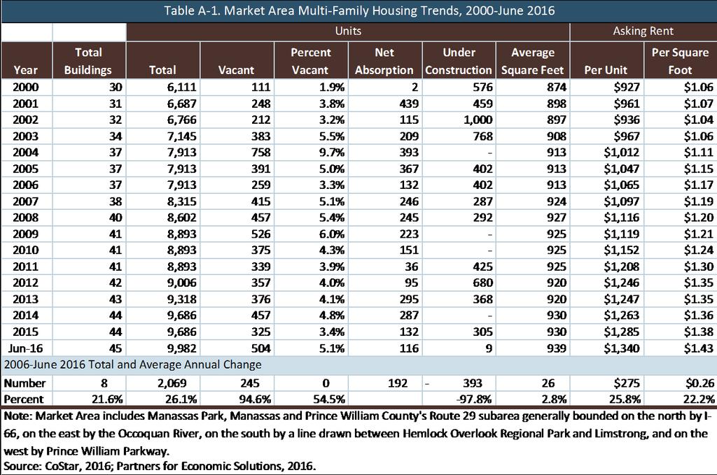
54 Residential Development Potential Development in Manassas Park s central area will compete within a market area that encompasses, the city, Manassas and parts of northeastern Prince William County. Shown on Map 1, the market area is generally bounded by I-66, the Occoquan River, a line from Hemlock Overlook Regional Park to Limstrong, and the Prince William Parkway. The market area has 112,500 residents living in 39,400 households. The number of households has grown 22.6 percent since 2000, an average rate of 1.3 percent per year. Following the housing crisis, renters have become a larger share of market area households, increasing from 33.2 percent in 2000 to 40.4 percent in Local and national trends favor a continued high share of renters into the future. Market area households are relatively large with an average household size of 3.04 persons. However, almost half (48.2 percent) of households have only one or two persons, who are often drawn to multifamily apartments and condominiums. Households in the market area have a median income of $77,919. Among renter households, 40.1 percent have incomes between $50,000 and $100,000, and 13.7 percent have incomes of $100,000 or more. These demographic trends suggest good demand for the type of quality multi-family housing that could be developed in Manassas Park s city center. Multi-family trends compiled by CoStar (Apartments.com) show that the market area includes 9,982 multi-family rental units. (See Table A-1.) The vacancy rate of only 5.1 percent is healthy; it increased A-2
55 from 3.4 percent in 2015 with the opening of 305 new units. The multi-family inventory has grown 63 percent since 2000 and 22.4 percent over the last decade. More than 1,300 units have been built since Annual absorption has averaged 192 units over the past decade. Rents now average $1,340 per month or $1.43 per square foot. As would be expected, rents among newer developments are higher with Class A buildings renting at $1,100 to $1,500 for one-bedroom units and $1,450 to $1,900 for twobedroom units. Proximity to the VRE station yields an extra rent premium. These rent levels are sufficient to support wood-frame construction of up to five stories with surface parking. They would need to increase significantly to support the cost of structured parking. Some potential cost savings could be achieved through some shared use of VRE parking in the evenings and on weekends. New residential development proposed for sites near the VRE station includes Palisades at Manassas Park, a 304-unit complex on Manassas Drive at Railroad Drive. The Elms at Signal Hill Station opened in 2016 in Prince William County within walking distance of the station and is planned for a total of 296 units. Other proposed multi-family developments include Richmond Station east of the Norfolk Southern Railroad and north of Liberia Avenue adjoining Signal Hill Park, which is planned for 70 multifamily units and 104 townhouses. Orchard Bridge has 368 new units of a planned total of 1,260 units along Route 28 just south of the Fairfax County line. Given the land use patterns of Manassas Park and surrounding jurisdictions, auto ownership is almost mandatory. This means that parking ratios need to be appropriate to the suburban setting. Using VRE for the daily commute of one of the household s wage earners possibly could allow a couple to reduce from one to two cars, but it will not eliminate the need for a car given the heavy dependence on auto access. Every apartment will generate a need for at least 1.5 to 2.0 parking spaces with additional spaces for visitor parking. There is no local precedent for paid parking. Retail Development Potential Retail demand is a function of the number of market area households within easy walking and driving distance, their incomes and the extent, nature and location of competitive retail operations. The market area that can be tapped by a retailer is defined as the area within easy driving distance from which the retailer is expected to draw 80 to 90 percent of its residentially-based customers. It is defined by distance, by the location of competitive retail clusters and by natural and man-made boundaries. When retailers seek sites, they are focused on several key criteria, including: a minimum number of current market area households (not projections of future households); minimum income levels and/or other characteristics (such as homeownership) shared by their likely customers; appropriate retail space with ceilings that are at least 14 feet high, glass fronts, typically 60 to 100 feet deep, with adequate loading and service areas; visibility from a major thoroughfare for effective marketing; convenient parking with three to five spaces per 1,000 square feet of retail space, preferably immediately adjacent to the store; A-3
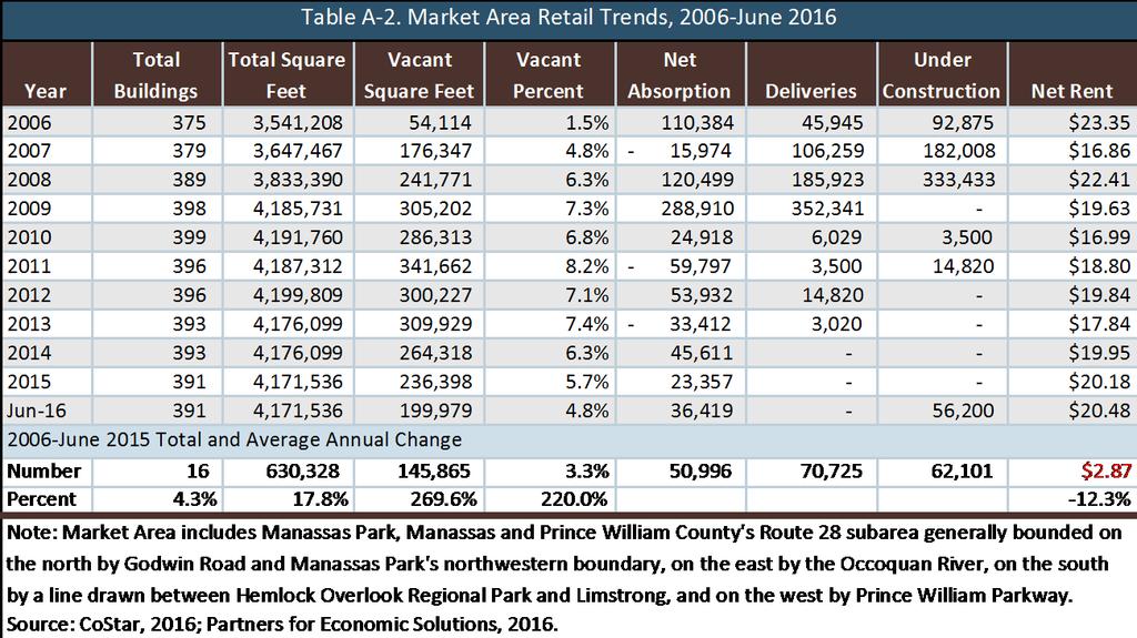
56 synergies with major activity generators, such as a grocery store or other anchor store, a library or recreation center, a transit station and/or a major programmed public space; competitive rents; and development incentives, such as allowances for interior fit-out and finishes. Most retail chains have strict requirements (such as minimum numbers of households within a threemile radius, minimum household incomes and minimum levels of pass-by traffic) that are based on their business model and lengthy research on what works for their businesses. At the same time, cities are seeking to activate their downtown streets and public spaces by including active uses on the first floors of office and residential buildings. Over the years, zoning requirements that all first-floor spaces include retail space have created unfortunate situations with retail spaces that have never been leased because they do not meet the criteria imposed by prospective retail tenants. Such requirements are best imposed only in locations that can reasonably compete for retail uses and in amounts appropriate to the scale of the market support. Building too much retail space can result in high retail vacancies and/or low sales for all of the retailers, increasing business failures and turnover. There are alternative approaches to activating streets and public areas. In residential buildings, the fitness center, business center and/or tenant lounge areas can be located to the first floor with extensive glass for views from the sidewalk. Civic facilities can be located on the first floor, such as a library or recreation use; they are less dependent on visibility from pass-by traffic. Childcare facilities could benefit from collocation with VRE parking. Landscaped areas and public art can soften a building s edge and improve the pedestrian experience on the adjoining sidewalk. Most mixed-use developments with 400 to 600 residential units do not generate enough internal demand to support much retail space. As a result, retailers typically need to attract shoppers from beyond the project borders. Most cannot succeed strictly on the strength of their own marketing and promotions. They need the benefit of visibility from a major thoroughfare to alert residents and visitors to their presence and then remind potential patrons that they are there. The Manassas retail market area, shown in Map 2, includes 4.2 million square feet of retail space with a current vacancy rate of 4.8 percent, down from a high of 8.2 percent in (See Table A-2.) Since 2006, net absorption has averaged 51,000 square feet with deliveries averaging 70,700 square feet annually. No space has been added since 2013, but 56,200 square feet is currently under construction in a new neighborhood center on Liberia Avenue and a childcare center in the Park Towers development behind the Residences at City Center. A-4

57 City Center has leased only two retail spaces, a bank and an insurance agency, since entering the market in 2009 with up to 26,132 square feet still available. In part, this reflects the owner s unwillingness to fund any tenant improvements and possibly the location of its parking across Manassas Drive adjacent to City Hall. The Palisades mixed-use development on Manassas Drive just east of Railroad Drive includes 22,750 square feet of retail space in its first phase. The second phase would expand on the south side of Manassas Drive to include another 17,600 square feet of retail space. On-site employees generate primarily lunchtime restaurant demand. Lunch business alone is not enough to support most restaurants. Almost all need to combine that lunchtime business with dinner, evening and weekend business. They need nearby residential development to generate that evening/weekend activity and to support and enliven the retail area. Most successful mixed-use developments, especially in the suburbs, devote a large majority of their space to residential units, typically 60 to 80 percent. Retail tenancy in most town center projects is primarily focused on restaurants, cafes and other businesses that can generate frequent repeat visits. Daily support uses, such as dry cleaners and banks, can be successful as well if they can offer convenient curbside parking that allows off-site residents with quick, convenient access. A-5
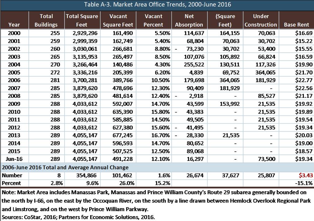
58 The location at the VRE station offers an opportunity to take advantage of homeward bound commuters with food retailers and restaurants. Retail development along Park Center Court would be appropriate only for the Manassas Drive and Park Center Court frontage. Few, if any, retail uses could be attracted further into the site s interior. One potential opportunity would be childcare for VRE commuters. Office Development Potentials It is unlikely that even a well-executed mixed-use development in the city center could attract a major corporate office use to the site. Trends in regional and national office markets suggest that demand for space in conventional singlepurpose office parks is waning in favor of offices in mixed-use districts that can offer a range of uses within easy walking distance. Many Millennials and other knowledge workers are gravitating to jobs in walkable mixed-use districts with easy access to restaurants, retail and services. As labor markets have become more competitive and businesses have become more dependent on being able to attract young workers, businesses are choosing offices in locations that appeal to these valuable workers. In metropolitan Washington, DC, that has resulted in shifts to urban and suburban sites around Metro stations so as to access transit-dependent workers from around the region. While VRE creates a transitoriented development potential, it will have minimal impact on office demand. Unlik Metro s 18-hour operations with frequent service in each direction, VRE operates primarily in rush hour to help commuters access jobs in Washington, Arlington and Alexandria. Only one mid-day train operates in the reverse direction. Employers receive no advantage from being located at an outboard commuter rail station that delivers neither employees nor customers, so there is minimal office demand generated by the VRE station. The primary office demand in Manassas Park is for professional and other services focused on nearby residents dental and medical offices, physical therapy, legal, insurance, real estate, home health care and tax services. Large tenants with more than 10,000 square feet of space in newer Manassas and Manassas Park office buildings are relativley few. They include training institutes, engineers, construction contractors and government agencies, such as the Federal Bureau of Investigation field office. Office trends in the Greater Manassas Market Area shown on Map 1 provide valuable context for this market assessment. This market area includes 4.1 million square feet of office space in 289 buildings with a 12.1-percent vacancy rate, as shown in Table A-3. Based on historical absorption trends, the current overhang of vacant space represents a six- to nine-year supply. The vacancy rate is down from 16.7 percent in 2013 but still well above healthy levels of six to eight percent. Since 2009, only 22,500 square feet of space has been added to the market area inventory. Even prior to the Great Recession, deliveries of new space averaged only 139,600 square feet per year from 2000 through The single building under construction is in Innovation Park near the George Mason University Science & Technology Campus for BerkleyNet, a worker s compensation insurance underwriter. An additional 500,000 square feet of space is proposed in the Market Area but not yet started, almost all located either along I-66 or in Innovation Park. A-6
59 Within a one-mile radius of the VRE Manassas Park station are 16 office buildings with 309,314 square feet and a current vacancy rate of 8.5 percent. Only two buildings have been built since 1990, both opening in 2006 Railroad Professional Building and Signal Hill Professional Building. With 30,000 square feet of space, 25 percent of the Railroad Professional Building is vacant. Signal Hill Professional Building is a condominium office building on Liberia Avenue with 10,924 square feet in five spaces available for sale. These vacancy levels would dissuade other developers from building in the area for three years or more. Competitive office buildings offer surface parking. Structured parking to achieve higher densities is an expense not typically justified by current office rent levels. Shared Parking Given the very specific blocks of time used for VRE commuter parking, there could be opportunities to share that parking with on-site retail, restaurant and residential uses whose needs peak in the evening and on weekends if located proximate to those uses. A-7
60 A-8
61 A-9
Longmont to Boulder Regional Trail Jay Road Connection DRAFT FINAL REPORT
 Longmont to Boulder Regional Trail Jay Road Connection DRAFT FINAL REPORT December 2018 Project Summary Boulder County, Colorado, in partnership with the City of Boulder, is evaluating options for multi-use
Blueways: Rivers, lakes, or streams with public access for recreation that includes fishing, nature observation, and opportunities for boating.
 Parks, Open Space and Trails PRINCE WILLIAM COUNTY 2008 COMPREHENSIVE PLAN TRAILS PLAN CONTENTS The components of the trails plan are: Intent Definitions Goals, Policies, and Action Strategies Trails Map
URBAN DESIGN REPORT. Proposed Residential Development, Old Church Road, Caledon East
 Proposed Residential Development, Old Church Road, Caledon East TABLE CONTENTS: 1.0 DEVELOPMENT 1.1 Introduction-Analysis of Guiding Principles and Documents 1.2 Community Design and Architectural Design
3. COLTA / HUGA CONNECTIONS - PRELIMINARY
 9 3. COLTA / HUGA CONNECTIONS - PRELIMINARY 3.1 COLTA The Chain of Lakes Trail Association (COLTA) trail, formerly identified as the Chester Spur Line, was completed and opened for use in June 2011. The
Airport Planning Area
 PLANNING AREA POLICIES l AIRPORT Airport Planning Area LOCATION AND CONTEXT The Airport Planning Area ( Airport area ) is a key part of Boise s economy and transportation network; it features a multi-purpose
Madison Metro Transit System
 Madison Metro Transit System 1101 East Washington Avenue Madison, Wisconsin, 53703 Administrative Office: 608 266 4904 Fax: 608 267 8778 TO: FROM: SUBJECT: Plan Commission Timothy Sobota, Transit Planner,
A. CONCLUSIONS OF THE FGEIS
 Chapter 11: Traffic and Parking A. CONCLUSIONS OF THE FGEIS The FGEIS found that the Approved Plan will generate a substantial volume of vehicular and pedestrian activity, including an estimated 1,300
IL 390 Station. Wood Dale Open House Summary 5/18/17
 Wood Dale Open House Summary 5/18/17 The first public open house for the Wood Dale Comprehensive Plan took place on May 18 th, 2017. The program was conducted as a fun community event and there were 216
Macleod Trail Corridor Study. Welcome. Macleod Trail Corridor Study Open House. Presentation of Proposed Design Concepts
 Macleod Trail Corridor Study Welcome Macleod Trail Corridor Study Open House Presentation of Proposed Design Concepts Study Purpose Develop a corridor plan for Macleod Trail that aligns with The City s:
Lake Erie Commerce Center Traffic Analysis
 LOCATION: East of NYS Route 5 at Bayview Road Town of Hamburg Erie County, New York PREPARED BY: Wendel Companies 140 John James Audubon Parkway Suite 200 Amherst, New York 14228 January 2012 i ii Table
CHAPTER 4: ALTERNATIVES
 MSP Long Term Comprehensive Plan Update Metropolitan Airports Commission 4.1 INTRODUCTION CHAPTER 4: ALTERNATIVES Several alternatives were developed and evaluated based on their capability to meet the
EXHIBIT 1. BOARD AUTHORIZATION FOR PUBLIC HEARING AND SUBSEQUENT ISSUANCE OF A JOINT DEVELOPMENT SOLICITATION
 EXHIBIT 1. BOARD AUTHORIZATION FOR PUBLIC HEARING AND SUBSEQUENT ISSUANCE OF A JOINT DEVELOPMENT SOLICITATION Washington Metropolitan Area Transit Authority Board Action/Information Summary @Action O Information
FEASIBILITY CRITERIA
 This chapter describes the methodology and criteria used to evaluate the feasibility of developing trails throughout the study areas. Land availability, habitat sensitivity, roadway crossings and on-street
JOSLIN FIELD, MAGIC VALLEY REGIONAL AIRPORT DECEMBER 2012
 1. Introduction The Federal Aviation Administration (FAA) recommends that airport master plans be updated every 5 years or as necessary to keep them current. The Master Plan for Joslin Field, Magic Valley
Site Location and Setting
 Memorandum Date: To: From: Subject: Kristy Le, Gary Black Steve Orem Santa Teresa County Park Historic Area Traffic and Parking Study Hexagon Transportation Consultants, Inc. has completed a traffic and
Non-Motorized Transportation
 Non-Motorized Transportation Non-motorized facilities are important components to the transportation system. They provide an environmentally-friendly, low-cost mode of travel. Some of the facilities can
Bloor Street West Rezoning Application for a Temporary Use By-law Final Report
 STAFF REPORT ACTION REQUIRED 3741 3751 Bloor Street West Rezoning Application for a Temporary Use By-law Final Report Date: June 12, 2007 To: From: Wards: Reference Number: Etobicoke York Community Council
AGENDA ITEM 5 D WAKULLA ENVIRONMENTAL INSTITUTE (WEI) TRAIL FEASIBILITY STUDY
 TRAIL FEASIBILITY STUDY") March 19, 2018 AGENDA ITEM 5 D WAKULLA ENVIRONMENTAL INSTITUTE (WEI) TRAIL FEASIBILITY STUDY TYPE OF ITEM: Action STATEMENT OF ISSUE The Wakulla Environmental Institute (WEI) Trail is one of several trails
March 19, 2018 AGENDA ITEM 5 D WAKULLA ENVIRONMENTAL INSTITUTE (WEI) TRAIL FEASIBILITY STUDY TYPE OF ITEM: Action STATEMENT OF ISSUE The Wakulla Environmental Institute (WEI) Trail is one of several trails
THE AIRTRAIN AIRPORT ACCESS SYSTEM JOHN F. KENNEDY INTERNATIONAL AIRPORT AIRPORT ACCESS SERVICE
 THE AIRTRAIN AIRPORT ACCESS SYSTEM JOHN F. KENNEDY INTERNATIONAL AIRPORT AIRPORT ACCESS SERVICE The JFK AirTrain airport access system interfaces with two existing regional transit systems; the Long Island
Washington Township MASTER PLAN. Addendum: Washington Township Master Plan
 Washington Township MASTER PLAN Addendum: Washington Township Master Plan CHAPTER XI RECREATION CORE DISTRICT Introduction The Recreation Core District generally encompasses the areas north of 30 Mile
Spadina Avenue Built Form Study Preliminary Report
 STAFF REPORT ACTION REQUIRED Spadina Avenue Built Form Study Preliminary Report Date: July 9, 2014 To: From: Wards: Reference Number: Toronto and East York Community Council Director, Community Planning,
Crystal City Station Improvements. Project Overview. Table 2: North Entrance. Table 1: South Entrance. 20th St. S 18th St. S.
 Table 1: South Entrance Table 2: North Entrance 20th St. S 18th St. S Proposed Second Entrance Crystal Drive Existing Station Location Platform Future 4 th Track Future New Airport Connection (by others)
7272 WISCONSIN AVENUE LOCAL AREA TRANSPORTATION REVIEW
 7272 LOCAL AREA TRANSPORTATION REVIEW AND TRANSPORTATION POLICY AREA REVIEW MONTGOMERY COUNTY, MARYLAND Submitted on behalf of Carr Properties Prepared by: Wells + Associates, Inc. Submission: July 1,
SUMMER VILLAGE OF SILVER SANDS. Municipal Development Plan
 SUMMER VILLAGE OF SILVER SANDS Municipal Development Plan Bylaw 253-2014 Adopted August 22, 2014 Summer Village of Silver Sands Municipal Development Plan Bylaw No. 253-2014 Page 2 1 INTRODUCTION 1.1 SETTING
RESORT AREA STRATEGIC ACTION PLAN (RASAP) STEERING COMMITTEE MEETING - APRIL 3, 2019
 STEERING COMMITTEE MEETING - APRIL 3, 2019") RESORT AREA STRATEGIC ACTION PLAN (RASAP) STEERING COMMITTEE MEETING - APRIL 3, 2019 Welcome & Introductions - Deb Zywna AGENDA FY 20 Resort CIP Proposed Projects - Kathy Warren ORDFBC Design Guidelines
RESORT AREA STRATEGIC ACTION PLAN (RASAP) STEERING COMMITTEE MEETING - APRIL 3, 2019 Welcome & Introductions - Deb Zywna AGENDA FY 20 Resort CIP Proposed Projects - Kathy Warren ORDFBC Design Guidelines
COMMUNICATIONS DEPARTMENT (Lisa Belsanti, Director) (Joshua Schare, Public Information Officer)
 (Joshua Schare, Public Information Officer)") CITY COUNCIL UNFINISHED BUSINESS AUGUST 21, 2017 SUBJECT: INITIATED BY: SUNSET STRIP ENTERTAINMENT SHUTTLE - PILOT PROGRAM HUMAN SERVICES & RENT STABILIZATION DEPARTMENT (Elizabeth Savage, Director) 'fj1f'..
CITY COUNCIL UNFINISHED BUSINESS AUGUST 21, 2017 SUBJECT: INITIATED BY: SUNSET STRIP ENTERTAINMENT SHUTTLE - PILOT PROGRAM HUMAN SERVICES & RENT STABILIZATION DEPARTMENT (Elizabeth Savage, Director) 'fj1f'..
Other Principle Arterials Minor Arterial Major Collector Minor Collector Local
 CHAPTER 10 TRANSPORTATION Introduction The system of public roads in East Pikeland Township is decidedly rural in character. Since the 1984, the road network has remained much the same, with the addition
Georgetown-Lewes Rail/Trail Study. Rail/Trail Study: Cool Spring to Cape Henlopen State Park New Road Extension (House Resolution No.
 Georgetown-Lewes Rail/Trail Study Rail/Trail Study: Cool Spring to Cape Henlopen State Park New Road Extension (House Resolution No. 47) August 22, 2011 Presentation Outline Background Benefits Statewide
Welcome to the Cross County Trail Public Input Session!
 Welcome to the Cross County Trail Public Input Session! Please sign in on the table below! What are we doing here? Camden County has proposed a bicycle and pedestrian trail spanning across the entire county.
TransAction Overview. Introduction. Vision. NVTA Jurisdictions
 Introduction Vision NVTA Jurisdictions In the 21 st century, Northern Virginia will develop and sustain a multimodal transportation system that enhances quality of life and supports economic growth. Investments
Westover Metropolitan Airport Master Plan Update
 Westover Metropolitan Airport Master Plan Update June 2008 INTRODUCTION Westover Metropolitan Airport (CEF) comprises the civilian portion of a joint-use facility located in Chicopee, Massachusetts. The
Chapter 1: Introduction Draft
 Chapter 1: Draft TABLE OF CONTENTS 1... 4 1.6.1 Stakeholder Engagement Plan... 10 Chapter 1 Page 2 TABLE OF EXHIBITS Exhibit 1.1-1 ABIA Annual Growth Since 1993... 5 Exhibit 1.4-1: ABIA Location Map...
12, 14 and 16 York Street - Amendments to Section 16 Agreement and Road Closure Authorization
 REPORT FOR ACTION 12, 14 and 16 York Street - Amendments to Section 16 Agreement and Road Closure Authorization Date: April 27, 2018 To: Toronto and East York Community Council From: Senior Strategic Director,
MMHP INVESTMENT SALES OPPORTUNITY. Investment Highlights. Property Overview. Manassas Mobile Home Park & 9011 Centreville Road Manassas, VA
 MMHP INVESTMENT SALES OPPORTUNITY 9009 & 9011 Centreville Road Manassas, VA Investment Highlights Centrally located, 100% leased mobile home park in the strong-performing City of Manassas, VA The 10.02-acre
Section II. Planning & Public Process Planning for the Baker/Carver Regional Trail began in 2010 as a City of Minnetrista initiative.
 Section II Planning & Public Process Planning for the began in 2010 as a City of initiative. city staff began discussions with the Park District on the possibility of a north/south regional trail connection
Treasure Island Supplemental Information Report Addendum
 1 1 1 1 0 1 0 1 0 1 Treasure Island Supplemental Information Report Addendum Introduction Purpose The purpose of this Supplemental Information Report (SIR) Addendum is to determine if the current land
A number of goals were identified during the initial work on this Big Lake Transportation Plan.
 C. Transportation General Background Information Big Lake s transportation system includes all the roads, paths and facilities that allow the movement of private vehicles, trains and planes, as well as
Arlington County Board Meeting Project Briefing. October 20, 2015
 Arlington County Board Meeting Project Briefing October 20, 2015 Project Map 2 Project Context Only Interstate in the Country limited to HOV only traffic during rush hours Stoplight at the end of I-66
This section evaluates the projected traffic operations and circulation impacts associated with the proposed upgrade and expansion of the LWRP.
 4.5 TRAFFIC AND CIRCULATION This section evaluates the projected traffic operations and circulation impacts associated with the proposed upgrade and expansion of the LWRP. 4.5.1 Environmental Setting Existing
Transportation Supporting Dulles Airport
 Transportation Supporting Dulles Airport Committee for Dulles Economic Development and Transportation Committee July 12, 2018 Tom Biesiadny, Director Fairfax County Multiple Transportation Improvements
MASTER PLAN EXECUTIVE SUMMARY
 Biscuit Run State Park Scottsville Road (State Route 20) Charlottesville, VA 22902 Biscuit Run State Park MASTER PLAN EXECUTIVE SUMMARY Department of Conservation and Recreation Division of Planning and
Project Deliverable 4.1.3d Individual City Report - City of La Verne
 Pomona Valley ITS Project Project Deliverable 4.1.3d Individual City Report - City of La Verne Prepared by: April 19, 2002 099017000.1 Copyright 2002, Kimley-Horn and Associates, Inc TABLE OF CONTENTS
Chapter 1: Introduction
 Chapter 1: TABLE OF CONTENTS 1... 4 1.1 Master Plan Study Content... 4 1.2 Purpose and Scope of Master Plan Study... 4 1.3 Airport History and Role... 6 1.4 Airport Location and Service Area... 6 1.5 ABIA
Section 106 Update Memo #1 Attachment D. Traffic Diversion & APE Expansion Methodology & Maps
 Section 106 Update Memo #1 Attachment D Traffic Diversion & APE Expansion Methodology & Maps I-65/I-70 North Split Interchange Reconstruction Project (Des. Nos. 1592385 & 1600808) Traffic Diversion and
The Baker/Carver Regional Trail is intended to
 Section V Design Guidance The Baker/Carver Regional Trail is intended to safely accommodate 183,000 annual visits, an array of non-motorized uses, a variety of skill levels, and persons with special needs.
University Region Non-Motorized Plan 2015
 Non-Motorized Transportation Non-motorized facilities are important components to the transportation system. They provide an environmentally-friendly, low-cost mode of travel. Some of the facilities can
SOUTH INTERCHANGE AREA
 Santaquin City General Plan 1 Location and Characteristics The South Interchange Area of Santaquin is located west of Interstate 15 and south of 500 South (Figure 1). It includes properties already annexed
Stage 2 ION: Light Rail Transit (LRT) from Kitchener to Cambridge
 from Kitchener to Cambridge") Stage 2 ION: Light Rail Transit (LRT) from Kitchener to Cambridge Public Consultation Centre (PCC) No. 3 Please Sign-in Cambridge City Hall November 21, 2017 2:00 to 8:00pm Preston Memorial Auditorium
Stage 2 ION: Light Rail Transit (LRT) from Kitchener to Cambridge Public Consultation Centre (PCC) No. 3 Please Sign-in Cambridge City Hall November 21, 2017 2:00 to 8:00pm Preston Memorial Auditorium
DEMOGRAPHICS AND EXISTING SERVICE
 EXECUTIVE SUMMARY The Central Corridor light-rail transit (LRT) project will open in 2014 and operate between downtown Minneapolis and downtown St. Paul, serving the University of Minnesota and University
US 380 FEASIBILITY STUDY
 US 380 FEASIBILITY STUDY Denton County CSJ(s): 0135-10-061, 0135-10-062 Public Meeting(s): January 15 & 22, 2019 WELCOME US 380 Denton County Feasibility Study DALLAS DISTRICT PUBLIC MEETING January 15
2433 Dufferin Street Zoning By-law Amendment Application - Preliminary Report
 STAFF REPORT ACTION REQUIRED 2433 Dufferin Street Zoning By-law Amendment Application - Preliminary Report Date: July 22, 2014 To: From: Wards: Reference Number: North York Community Council Director,
2016 Regional Transportation Alternatives Program (TAP) Grant Application
 Grant Application") 2016 Regional Transportation Alternatives Program (TAP) Grant Application PROJECT TITLE: Yelm-Tenino Trail Extension Feasibility Study TRPC use only GENERAL PROJECT INFORMATION Agency or Organization City
2016 Regional Transportation Alternatives Program (TAP) Grant Application PROJECT TITLE: Yelm-Tenino Trail Extension Feasibility Study TRPC use only GENERAL PROJECT INFORMATION Agency or Organization City
Parkland County Municipal Development Plan Amendment Acheson Industrial Area Structure Plan
 Parkland County Municipal Development Plan Amendment Acheson Industrial Area Structure Plan New Plan Acheson Industrial Area Structure Plan Amendment Parkland County Municipal Development Plan Board Reference
TORONTO TRANSIT COMMISSION REPORT NO.
 Revised: March/13 TORONTO TRANSIT COMMISSION REPORT NO. MEETING DATE: November 18, 2013 SUBJECT: YONGE-EGLINTON AND EGLINTON WEST INTERCHANGE STATIONS METROLINX EGLINTON CROSSTOWN LIGHT RAIL TRANSIT PROJECT
4. Safety Concerns Potential Short and Medium-Term Improvements
 NH Route 104 Access Management Study Page 19 4. Safety Concerns Potential Short and Medium-Term Improvements Potential safety improvement strategies are listed by priority based on field observations by
Resolution of Support for the Ettrick Site as the Future Location of the Tri-Cities Multimodal Station
 CHESTERFIELD COUNTY BOARD OF SUPERVISORS Page 1 of 3 AGENDA Meeting Date: October 28, 2015 Item Number: 8.B.1.b. Subject: Resolution of Support for the Ettrick Site as the Future Location of the Tri-Cities
At the time, the portion of the line through Eagle County remains wholly under the ownership of Union Pacific Railroad (UP).
.") Chapter 5 The Railroad Corridor as a Trail Corridor The intent of this chapter is to identify how the rail corridor, if available for lease or purchase in all or part, could be incorporated into the core
Chapter 5 The Railroad Corridor as a Trail Corridor The intent of this chapter is to identify how the rail corridor, if available for lease or purchase in all or part, could be incorporated into the core
Westbrook Station. Transit Oriented Development Opportunity
 DEVELOPM Westbrook Station Transit Oriented Development Opportunity OPPOR Table of Contents Prime Real Estate Development Opportunity page 1 Calgary City of Opportunity page 3 What is Transit Oriented
Vista Field Airport. Master Plan Update. February, Prepared for: Port of Kennewick One Clover Island Kennewick, Washington
 Vista Field Airport February, 2006 Prepared for: Port of Kennewick One Clover Island Kennewick, Washington 99336 Prepared by: J-U-B ENGINEERS, Inc. 2810 W. Clearwater Avenue, Suite 201 Kennewick, Washington
A. From I-68 in Monongalia County, West Virginia to SR 6119 in Fayette County, Pennsylvania 1
 Mon-Fayette Transportation Project A. From I-68 in Monongalia County, West Virginia to SR 6119 in Fayette County, Pennsylvania 1 The Mon/Fayette Transportation Project (MFTP) from I-68 in West Virginia
CHAPTER 1 EXECUTIVE SUMMARY
 CHAPTER 1 EXECUTIVE SUMMARY 1 1 EXECUTIVE SUMMARY INTRODUCTION William R. Fairchild International Airport (CLM) is located approximately three miles west of the city of Port Angeles, Washington. The airport
Appendix F International Terminal Building Main Terminal Departures Level and Boarding Areas A and G Alternatives Analysis
 Appendix F International Terminal Building Main Terminal Departures Level and Boarding Areas A and G Alternatives Analysis ITB MAIN TERMINAL DEPARTURES LEVEL & BOARDING AREAS A & G ALTERNATIVES ANALYSIS
MARSHALL Subdivision. Township of Springwater, County of Simcoe. Traffic Brief for: Ontario Inc. Type of Document: Final Report
 MARSHALL Subdivision Township of Springwater, County of Simcoe Traffic Brief for: 489469 Ontario Inc. Type of Document: Final Report Project Number: JDE 1521 Date Submitted: October 19 th, 2016 10 / 19
Mountain Valley Pipeline, LLC Mountain Valley Pipeline Project Docket No. CP
 16. Prior to construction, Mountain Valley shall file with the Secretary, for review and approval by the Director of OEP, a segment-specific construction and operation access plan for the area between
FORECASTING FUTURE ACTIVITY
 EXECUTIVE SUMMARY The Eagle County Regional Airport (EGE) is known as a gateway into the heart of the Colorado Rocky Mountains, providing access to some of the nation s top ski resort towns (Vail, Beaver
2. Goals and Policies. The following are the adopted Parks and Trails Goals for Stillwater Township:
 D. PARKS AND TRAILS 1. Introduction Stillwater Township s population is relatively low, with most residents living on rural residences on large lots. The need for active park space has been minimal in
Second Avenue: Union Street to Lenora Street, Condominium Owners c/o Michael McQuaid 1521 Second Avenue Seattle, WA 98101
 Second Avenue: Union Street to Lenora Street, Condominium Owners c/o Michael McQuaid 1521 Second Avenue Seattle, WA 98101 Subject: New Development - Cumulative Downtown Alley Traffic Congestion and Safety
Construction Staging Adelaide Street West
 REPORT FOR ACTION Construction Staging Adelaide Street West Date: October 6, 2016 To: Toronto and East York Community Council From: Acting Director, Transportation Services, Toronto and East York District
Executive Summary. MASTER PLAN UPDATE Fort Collins-Loveland Municipal Airport
 Executive Summary MASTER PLAN UPDATE Fort Collins-Loveland Municipal Airport As a general aviation and commercial service airport, Fort Collins- Loveland Municipal Airport serves as an important niche
PURPOSE AND NEED (CONCURRENCE POINT 1) NEW CANADA ROAD PROJECT FROM STATE ROUTE 1 (U.S. HIGHWAY 70) TO U.S. INTERSTATE 40
 NEW CANADA ROAD PROJECT FROM STATE ROUTE 1 (U.S. HIGHWAY 70) TO U.S. INTERSTATE 40") PURPOSE AND NEED (CONCURRENCE POINT 1) NEW CANADA ROAD PROJECT FROM STATE ROUTE 1 (U.S. HIGHWAY 70) TO U.S. INTERSTATE 40 Project Description The primary purpose of this project is to improve the major
PURPOSE AND NEED (CONCURRENCE POINT 1) NEW CANADA ROAD PROJECT FROM STATE ROUTE 1 (U.S. HIGHWAY 70) TO U.S. INTERSTATE 40 Project Description The primary purpose of this project is to improve the major
Addendum - Airport Development Alternatives (Chapter 6)
") Bowers Field Addendum - Airport Development Alternatives (Chapter 6) This addendum to the Airport Development Alternatives chapter includes the preferred airside development alternative and the preliminary
Bowers Field Addendum - Airport Development Alternatives (Chapter 6) This addendum to the Airport Development Alternatives chapter includes the preferred airside development alternative and the preliminary
Draft Concept Alternatives Analysis for the Inaugural Airport Program September 2005
 Section 10 Preferred Inaugural Airport Concept 10.0 Introduction The Preferred Inaugural Airport Concept for SSA was developed by adding the preferred support/ancillary facilities selected in Section 9
November 11, 2009 BY . Planning and Growth Management Department 110 Laurier Avenue West, 4 th Floor Ottawa, Ontario K1P 1J1. Dear Mr.
 November 11, 2009 Planning and Growth Management Department 110 Laurier Avenue West, 4 th Floor Ottawa, Ontario K1P 1J1 BY E-MAIL Attention: Mr. Don Herweyer Dear Mr. Herweyer: Reference: Abbott-Fernbank
PARKING CAPACITY REQUIREMENTS
 PARKING CAPACITY REQUIREMENTS Presented to: Antaramian Development Corporation 365 5 th Avenue South Naples, Florida 34102 CONTENTS Page INTRODUCTION... 1 BACKGROUND... 2 EXISTING PARKING CONDITIONS...
UNION STATION ACCESS AND CAPACITY IMPROVEMENT STUDY PROJECT REPORT
 UNION STATION ACCESS AND CAPACITY IMPROVEMENT STUDY PROJECT REPORT Washington Metropolitan Area Transit Authority Department of Planning and Joint Development In Association with District of Columbia Department
NEWBORO AND PORTLAND HARBOUR REDVELOPMENT PLANS
 INTRODUCTION The Municipal docks in both Newboro and Portland were transferred to the Township of Rideau Lakes by Parks Canada in 2002. Little has been done to improve the docks physical condition or role
SECTION 5 ALTERNATIVE DEVELOPMENT CONCEPT ANALYSES
 SECTION 5 ALTERNATIVE DEVELOPMENT CONCEPT ANALYSES 5.1 INTRODUCTION This section investigates Airfield Development Alternatives, generalized Land Use Alternatives, and more detailed General Aviation Alternatives.
Passenger Facility Charge (PFC) Program: Eligibility of Ground Access Projects Meeting
 Program: Eligibility of Ground Access Projects Meeting") This document is scheduled to be published in the Federal Register on 05/03/2016 and available online at http://federalregister.gov/a/2016-10334, and on FDsys.gov [ 4910-13] DEPARTMENT OF TRANSPORTATION
This document is scheduled to be published in the Federal Register on 05/03/2016 and available online at http://federalregister.gov/a/2016-10334, and on FDsys.gov [ 4910-13] DEPARTMENT OF TRANSPORTATION
Lafourche Parish Government REQUEST FOR QUALIFICATIONS. Landscape Architectural Services
 Lafourche Parish Government REQUEST FOR QUALIFICATIONS Landscape Architectural Services Bayou Lafourche Parish Multi-Use Path Feasibility Study Phase 1 And Bayou Lafourche Parish Multi-Use Path Feasibility
PREFACE. Service frequency; Hours of service; Service coverage; Passenger loading; Reliability, and Transit vs. auto travel time.
 PREFACE The Florida Department of Transportation (FDOT) has embarked upon a statewide evaluation of transit system performance. The outcome of this evaluation is a benchmark of transit performance that
McLean Citizens Association Transportation Committee Project Briefing
 McLean Citizens Association Transportation Committee Project Briefing November 10, 2015 Project Map 2 Project Context Only Interstate in the Country limited to HOV only traffic during rush hours Stoplight
Transportation TRANSPORTATION PROJECTS
 Transportation TRANSPORTATION PROJECTS Balls Ford Road Interchange Total Project Cost $142.9M This project includes the construction of a new diverging diamond interchange at Route 234 Bypass (Prince William
TEMPE BEACH PARK - RECOMMENDATIONS
 TEMPE BEACH PARK - RECOMMENDATIONS Tempe Beach Park has the potential to become a regional destination park, but it suffers from a host of physical and operational problems, as well as structural flaws.
Northeast Quadrant Distinctive Features
 NORTHEAST QUADRANT Northeast Quadrant Distinctive Features LAND USE The Northeast Quadrant includes all the area within the planning area that is east of Interstate 5 and to the north of State Route 44.
Memorandum / Letter of Intent
 VERONA WAUKESHA KENOSHA APPLETON WESTON Memorandum / Letter of Intent To: Adam Sayre, Director of Planning & Development, City of Verona From: Kevin Yeska, JSD Professional Services, Inc. www.jsdinc.com
To apprise Council of the process and timeline for the preparation of the Final Concept Plan and report; and
 Corporate NO: R243 Report COUNCIL DATE: November 20, 2006 REGULAR COUNCIL TO: Mayor & Council DATE: November 15, 2006 FROM: Acting General Manager, Planning and Development FILE: 0850-20 (CF) SUBJECT:
SR 934 Project Development And Environment (PD&E) Study
 Study") SR 934 Project Development And Environment (PD&E) Study Project Advisory Group Meeting March 1, 2018 State Road 934/NE/NW 79th Street from west of I-95 (NW 13th CT) to N. Bayshore Drive PD&E STUDY SR 934/NE/NW
SR 934 Project Development And Environment (PD&E) Study Project Advisory Group Meeting March 1, 2018 State Road 934/NE/NW 79th Street from west of I-95 (NW 13th CT) to N. Bayshore Drive PD&E STUDY SR 934/NE/NW
Commuter Park and Ride Steering Committee Meeting Notes August 7, :00 a.m. to 11:00 a.m. Attendees Name Organization Phone
 Commuter Park and Ride Steering Committee Meeting Notes August 7, 2013 10:00 a.m. to 11:00 a.m. Attendees Name Organization Email Phone Eileen Horn Lawrence/Douglas County ehorn@lawrenceks.org 785-330-3121
PROPOSED PARK ALTERNATIVES
 8 Chimne y Rock State Park M a ster Pl an 2011 PROPOSED PARK ALTERNATIVES Introduction Three different park development concepts were prepared and presented to the citizens of North Carolina through a
CITY PLANNING COMMISSION AGENDA ITEM NOS: 5.A, 5.B STAFF: MICHAEL SCHULTZ
 CPC Agenda Page 83 CITY PLANNING COMMISSION AGENDA ITEM NOS: 5.A, 5.B STAFF: MICHAEL SCHULTZ FILE NO(S): CPC DP 03-00259-A5MN11 QUASI-JUDICIAL AR NV 11-00538 QUASI-JUDICIAL PROJECT: BROADMOOR TEMPORARY
MORGAN CREEK GREENWAY Final Report APPENDICES
 APPENDICES MORGAN CREEK GREENWAY Appendix A Photos of Existing Conditions in Trail Corridor Photos of existing conditions Main trail corridor - February 2009 Photos of existing conditions south bank Morgan
Town of Oakfield Agricultural and Farmland Protection Plan
 SECTION III COMMUNITY OVERVIEW A. Regional Setting / Location The Town of Oakfield is located in the northwestern portion of Genesee County. Located west of New York's Finger Lakes, the Town is uniquely
HAMPTON ROADS CROSSINGS PATRIOTS CROSSING AND HRBT
 HRTPO Board Meeting March 21, 2013 Agenda ITEM #9: HAMPTON ROADS CROSSINGS PATRIOTS CROSSING AND HRBT Congestion at the Hampton Roads Bridge-Tunnel (HRBT) on I-64 has long been identified as a problem
DRAFT GENERAL IMPLEMENTATION PLAN AND SPECIFIC IMPLEMENTATION PLAN MIDDLETON MUNICIPAL AIRPORT MOREY FIELD. Revised 12/12/03
 DRAFT GENERAL IMPLEMENTATION PLAN AND SPECIFIC IMPLEMENTATION PLAN MIDDLETON MUNICIPAL AIRPORT MOREY FIELD Revised 12/12/03 As recommended for approval by the Plan Commission General Project Description
Classifications, Inventory and Level of Service
 Classifications, Inventory and Level of Service Section 3 Kenmore Park, Recreation and Open Space Plan 1 P a g e Classifications and Inventory Park Classifications Kenmore classifies its parks based upon
China Creek North Park Upgrades and Glen Pump Station. Park Board Committee Meeting Monday, July 10, 2017
 China Creek North Park Upgrades and Glen Pump Station Park Board Committee Meeting Monday, July 10, 2017 Purpose The purpose of this presentation is to: Share the results of the public engagement processes;
The Transportation Corridor Overlay District
 The Transportation Corridor Overlay District The Transportation Corridor Overlay District is a policy framework under which certain potentially beneficial development proposals may be considered, given
Destination Lindbergh
 Technical Appendix 16 Destination Lindbergh Appendix Contents Destination Lindbergh... TA 16-2 2050 Regional Transportation Plan Destination Lindbergh Destination Lindbergh is a comprehensive planning
STAFF REPORT. Airport Land Use Plan Consistency Review: Santa Barbara Airport Master Plan. MEETING DATE: November 19, 2015 AGENDA ITEM: 7D
 STAFF REPORT SUBJECT: Airport Land Use Plan Consistency Review: Santa Barbara Airport Master Plan MEETING DATE: AGENDA ITEM: 7D STAFF CONTACT: Peter Imhof, Andrew Orfila RECOMMENDATION: Adopt findings
ROAD AND TRAIL PROJECT APPROVAL
 ROAD AND TRAIL PROJECT APPROVAL www.marincountyparks.org Marin County Parks, 3501 Civic Center Dr, Suite 260, San Rafael, CA 94903 DATE: July 12, 2017 PRESERVE: Gary Giacomini Open Space Preserve PROJECT: