Hydraulic Report. Trail 5 Snowmobile Trail Over Mulligan Creek. Prepared By: COLEMAN ENGINEERING COMPANY Karisa V. Falls, P.E.
|
|
|
- Dortha Gardner
- 5 years ago
- Views:
Transcription


1 Prepared for: Prepared by: Marquette County Road Commission Coleman Engineering Company Marquette, Michigan Iron Mountain, MI December 2011 Hydraulic Report Trail 5 Snowmobile Trail Over Mulligan Creek Prepared By: COLEMAN ENGINEERING COMPANY Karisa V. Falls, P.E
2 Contents 1.0 Introduction Method of Analysis Variables and Coefficients Starting Point Discussion Conclusion... 2 List of Appendices Appendix A HEC-RAS Computations Appendix B Profile Sheets Appendix C Topographic Map and HEC-RAS Section Map Appendix D Bridge Plans Appendix E Cross Sections: Existing Channel, Proposed Bridge Appendix F Damage Wavier Appendix G Flow Rate Data Appendix H Site Photographs Appendix I USGS Quadrangle Map and River Gradient Calculation
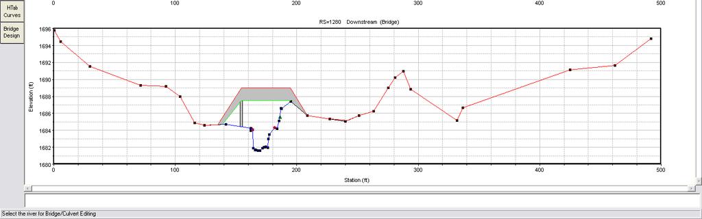
3 CEC Introduction This Hydraulic report has been prepared for the Marquette County Road Commission to analyze the crossing of the Mulligan Creek for the proposed Trail 5 Snowmobile Trail relocation. The site is located in Section 27 of Township 50N, Range 29W (Lat /Long ) in Michigamme Township, Marquette County. This proposed alignment location requires a new bridge as there is no existing bridge at this site. 2.0 Method of Analysis The hydraulic analysis was performed using U.S. Army Corps of Engineers Hydraulic Engineering Centers River Analysis System (HEC-RAS) computer program, Version Steady state flow data was obtained from The Michigan Department of Environmental Quality (MDEQ). 3.0 Variables and Coefficients Manning s n-values were selected from Table 3.1 of the HEC-RAS Hydraulic Reference Manual. The main channel is fairly uniform with some weeds and stones; therefore, a coefficient of was selected. The overbanks were given a coefficient of 0.1 due to the fact these areas are swampy with dense brush and vegetation. Representative photographs of Mulligan Creek at the proposed crossing site are located in Appendix H. Expansion and contraction coefficients of 0.30 and 0.50 were selected in accordance with Table 3.3 of the HEC-RAS Hydraulic Reference Manual. 4.0 Starting Point The starting water surface elevation was calculated by the Slope-Conveyance Method performed by HEC-RAS. An average Channel slope of was calculated using a USGS quadrangle map and used for the normal depth boundary condition. Calculations are included in Appendix I. The starting point of the stream analysis is a surveyed cross section approximately 1,180 feet downstream of the proposed crossing. This location is far enough downstream to be outside of the influence of the proposed bridge. 5.0 Discussion The main channel of Mulligan Creek is variable in width and well defined. Above the 10- year flood event a large portion of the flow is carried by the overbanks. The river gradient is relatively flat and the flow is sub-critical for all flood events.
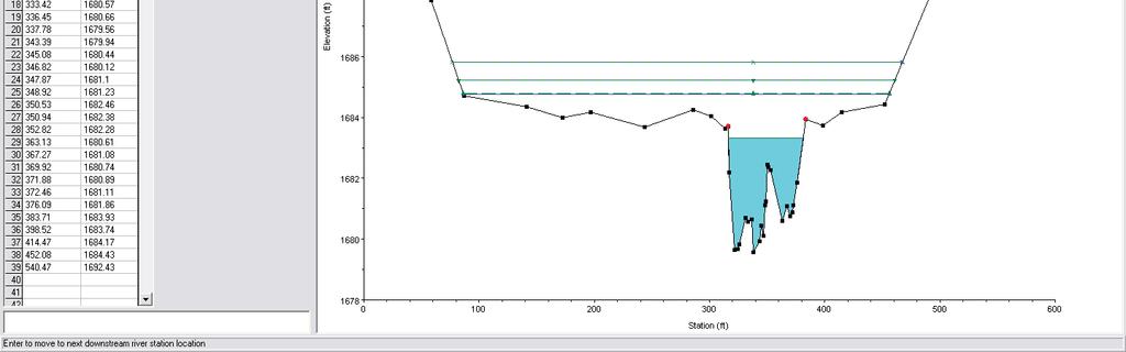
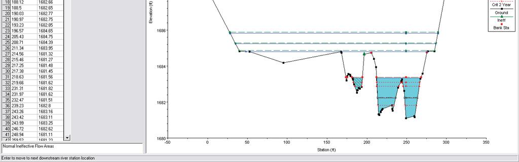
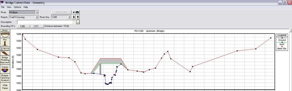
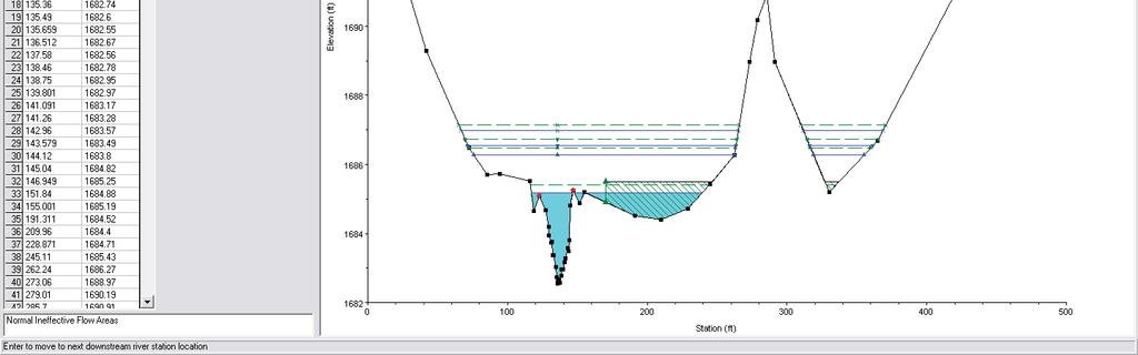
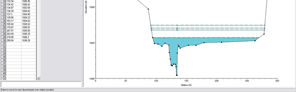
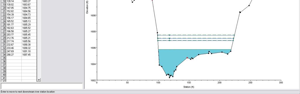
4 CEC 2 The river cross sections are placed in HEC-RAS at distances measured along the center line of the channel. In some cases, the surveyed cross sections near the proposed bridge were adjusted up or downstream as required to accurately model the bridge. A plan view of the sections is shown in Appendix C. Ineffective flow areas were added to the sections that show a pool or low area that is not part of the main flowing channel, but become part of the flowing area during larger flood events. The proposed bridge is a 40-foot long by 14-foot wide prefabricated steel structure with wood decking. The approach ramps are wood, the north ramp is 25 feet long and the south ramp is 15 feet long. The concrete abutments for the bridge will be placed on the natural soil and the stream banks will be stabilized with heavy rip rap; sized and placed in accordance with the Michigan Department of Transportation current Standard Specifications for Construction. The proposed bridge spans the entire width of the main channel without restrictions. The abutments, ramps, and approach cut off a portion of the overbank flow area and ineffective flow areas have been added in the overbank portions of the cross sections upstream and downstream of the proposed bridge, as suggested in Chapter 5 of the HEC-RAS Hydraulic Reference Manual. Placement of the proposed trail and bridge structure across the flood plain and stream reduces the overbank conveyance which increases the energy gradient elevation upstream of the proposed bridge. In order to find the extent of impact, additional cross sections were extrapolated upstream using the last surveyed cross section and the estimated river gradient. The limit of the impact was found to be 916 feet upstream of the proposed bridge. At this point there is no increase in the 100-year flood stage. A summary of these results for both the existing channel and the proposed 40-foot bridge are shown in Table 1. The impact is contained within one parcel and a damage waiver has been obtained and is included in Appendix F. 6.0 Conclusion An increase of 0.14 feet in energy gradient elevation for the 100-year flow event is seen at the first surveyed cross section upstream of the proposed bridge. This increase in energy gradient elevation is reduced to zero at 916 feet upstream of the bridge. Additionally, there is an increase of 0.06 feet per second in channel velocity for the 100- year flow event at the proposed bridge.
5 Hydraulic Computations of Bridge Option Trail 5 Snowmobile Trail Mulligan Creek 11/28/2011 Table 1 HEC RAS Analysis Results Velocity in Channel at Bridge Flow Through Bridge Water Surface Elevation at Upstream Face of Bridge Energy Gradient Elevation at Upstream Face of Bridge Energy Gradient Elevation at 233' Upstream of Bridge Energy Gradient Elevation at 425' Upstream of Bridge Energy Gradient Elevation at 566' Upstream of Bridge Energy Gradient Elevation at 916' Upstream of Bridge (ft/sec) (cfs) (feet) (feet) (feet) (feet) (feet) (feet) River Station 1280* River Station 1289 River Station 1289 River Station 1522 River Station 1714 River Station 1855 River Station year 100 year 10 year 100 year 500 year 100 year 100 year 100 year 100 year 100 year (340cfs) Model Configuration (340cfs) (130 cfs) (340cfs) (550 cfs) (340cfs) Change (340cfs) Change (340cfs) Change (340cfs) Change (340cfs) Change Existing Conditions Proposed Bridge *The River Station 1280 is the station location for the proposed bridge. River Station 1280 does not occur in the Exsiting Conditions calculations because there is no bridge. The values for the Existing Conditions were taken from the higher values of the cross sections upstream and down stream (Stations 1289 and 1271) of where the proposed bridge is located.
6 APPENDIX A HEC-RAS COMPUTATIONS
7 Computations The HEC-RAS data files are included in electronically as called file called: HEC-RAS_Trail 5_Mulligan Creek.zip A Profile Output Table of the analysis results for the existing and proposed conditions are included on the following pages to provide a brief summary.
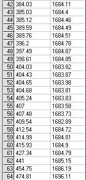
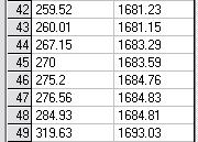
8 HEC-RAS Plan: Existing River: Mulligan Reach: Trail 5 Crossing Reach River Sta Profile Q Total Min Ch El W.S. Elev Crit W.S. E.G. Elev E.G. Slope Vel Chnl Flow Area Top Width Froude # Chl (cfs) (ft) (ft) (ft) (ft) (ft/ft) (ft/s) (sq ft) (ft) Trail 5 Crossing Year Trail 5 Crossing Year Trail 5 Crossing Year Trail 5 Crossing Year Trail 5 Crossing Year Trail 5 Crossing Year Trail 5 Crossing Year Trail 5 Crossing Year Trail 5 Crossing Year Trail 5 Crossing Year Trail 5 Crossing Year Trail 5 Crossing Year Trail 5 Crossing Year Trail 5 Crossing Year Trail 5 Crossing Year Trail 5 Crossing Year Trail 5 Crossing Year Trail 5 Crossing Year Trail 5 Crossing Year Trail 5 Crossing Year Trail 5 Crossing Year Trail 5 Crossing Year Trail 5 Crossing Year Trail 5 Crossing Year Trail 5 Crossing Year Trail 5 Crossing Year Trail 5 Crossing Year Trail 5 Crossing Year Trail 5 Crossing Year Trail 5 Crossing Year Trail 5 Crossing Year Trail 5 Crossing Year Trail 5 Crossing Year
9 HEC-RAS Plan: Existing River: Mulligan Reach: Trail 5 Crossing (Continued) Reach River Sta Profile Q Total Min Ch El W.S. Elev Crit W.S. E.G. Elev E.G. Slope Vel Chnl Flow Area Top Width Froude # Chl (cfs) (ft) (ft) (ft) (ft) (ft/ft) (ft/s) (sq ft) (ft) Trail 5 Crossing Year Trail 5 Crossing Year Trail 5 Crossing Year Trail 5 Crossing Year Trail 5 Crossing Year Trail 5 Crossing Year Trail 5 Crossing Year Trail 5 Crossing Year Trail 5 Crossing Year Trail 5 Crossing Year Trail 5 Crossing Year Trail 5 Crossing Year Trail 5 Crossing Year Trail 5 Crossing Year Trail 5 Crossing Year Trail 5 Crossing Year Trail 5 Crossing Year Trail 5 Crossing Year Trail 5 Crossing Year Trail 5 Crossing Year Trail 5 Crossing Year Trail 5 Crossing Year Trail 5 Crossing Year
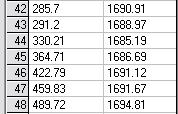
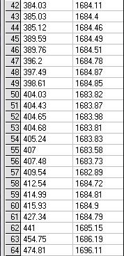
10 HEC-RAS Plan: Proposed Bridge River: Mulligan Reach: Trail 5 Crossing Reach River Sta Profile Q Total Min Ch El W.S. Elev Crit W.S. E.G. Elev E.G. Slope Vel Chnl Flow Area Top Width Froude # Chl (cfs) (ft) (ft) (ft) (ft) (ft/ft) (ft/s) (sq ft) (ft) Trail 5 Crossing Year Trail 5 Crossing Year Trail 5 Crossing Year Trail 5 Crossing Year Trail 5 Crossing Year Trail 5 Crossing Year Trail 5 Crossing Year Trail 5 Crossing Year Trail 5 Crossing Year Trail 5 Crossing Year Trail 5 Crossing Year Trail 5 Crossing Year Trail 5 Crossing Year Trail 5 Crossing Year Trail 5 Crossing Year Trail 5 Crossing Year Trail 5 Crossing Year Trail 5 Crossing Year Trail 5 Crossing Year Trail 5 Crossing Year Trail 5 Crossing Year Trail 5 Crossing Year Trail 5 Crossing Year Trail 5 Crossing Year Trail 5 Crossing 1280 BR U 10 Year Trail 5 Crossing 1280 BR U 100 Year Trail 5 Crossing 1280 BR U 200 Year Trail 5 Crossing 1280 BR U 500 Year Trail 5 Crossing 1280 BR D 10 Year Trail 5 Crossing 1280 BR D 100 Year Trail 5 Crossing 1280 BR D 200 Year Trail 5 Crossing 1280 BR D 500 Year Trail 5 Crossing Year Trail 5 Crossing Year
11 HEC-RAS Plan: Proposed Bridge River: Mulligan Reach: Trail 5 Crossing (Continued) Reach River Sta Profile Q Total Min Ch El W.S. Elev Crit W.S. E.G. Elev E.G. Slope Vel Chnl Flow Area Top Width Froude # Chl (cfs) (ft) (ft) (ft) (ft) (ft/ft) (ft/s) (sq ft) (ft) Trail 5 Crossing Year Trail 5 Crossing Year Trail 5 Crossing Year Trail 5 Crossing Year Trail 5 Crossing Year Trail 5 Crossing Year Trail 5 Crossing Year Trail 5 Crossing Year Trail 5 Crossing Year Trail 5 Crossing Year Trail 5 Crossing Year Trail 5 Crossing Year Trail 5 Crossing Year Trail 5 Crossing Year Trail 5 Crossing Year Trail 5 Crossing Year Trail 5 Crossing Year Trail 5 Crossing Year Trail 5 Crossing Year Trail 5 Crossing Year Trail 5 Crossing Year Trail 5 Crossing Year Trail 5 Crossing Year Trail 5 Crossing Year Trail 5 Crossing Year Trail 5 Crossing Year Trail 5 Crossing Year Trail 5 Crossing Year Trail 5 Crossing Year Trail 5 Crossing Year Trail 5 Crossing Year Trail 5 Crossing Year Trail 5 Crossing Year Trail 5 Crossing Year
12 APPENDIX B PROFILE SHEETS
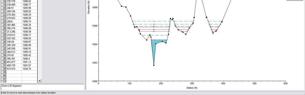
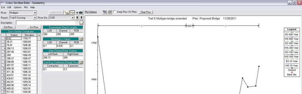
13 Trail 5 Mulligan Plan: Existing 11/28/2011 Mulligan Trail 5 Crossing Main Channel Distance (ft) Legend EG 500 Year WS 500 Year EG 100 Year WS 100 Year Crit 500 Year EG 10 Year WS 10 Year Crit 100 Year Crit 10 Year Ground Elevation (ft)
14 Trail 5 Mulligan-bridge extended Plan: Proposed Bridge 11/29/2011 Mulligan Trail 5 Crossing Main Channel Distance (ft) Legend EG 500 Year WS 500 Year EG 200 Year WS 200 Year EG 100 Year WS 100 Year Crit 500 Year Crit 200 Year EG 10 Year WS 10 Year Crit 100 Year Crit 10 Year Ground Elevation (ft)
15 APPENDIX C TOPOGRAPHIC MAP AND HEC-RAS SECTION MAP
16 Mulligan Creek
17 Mulligan Creek
18 APPENDIX D BRIDGE PLANS
19 Mulligan Creek
20
21 APPENDIX E CROSS SECTIONS
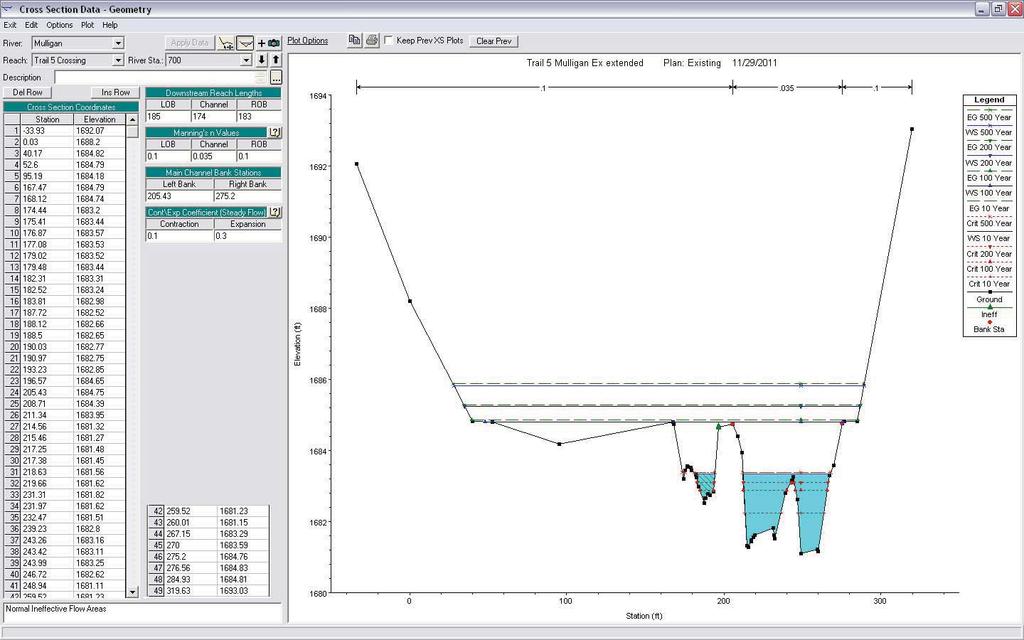
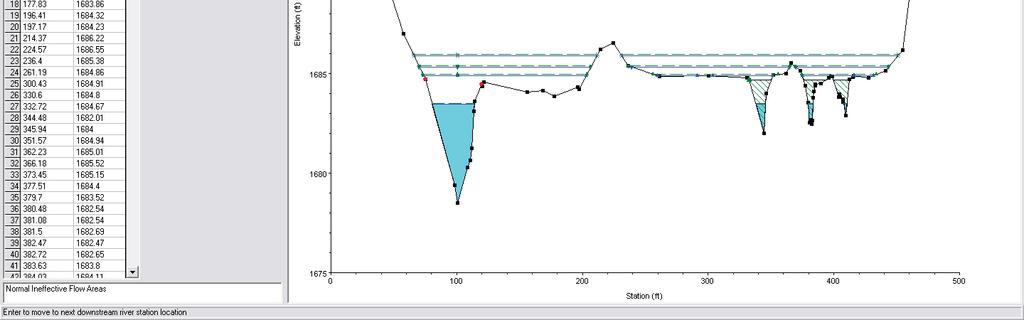
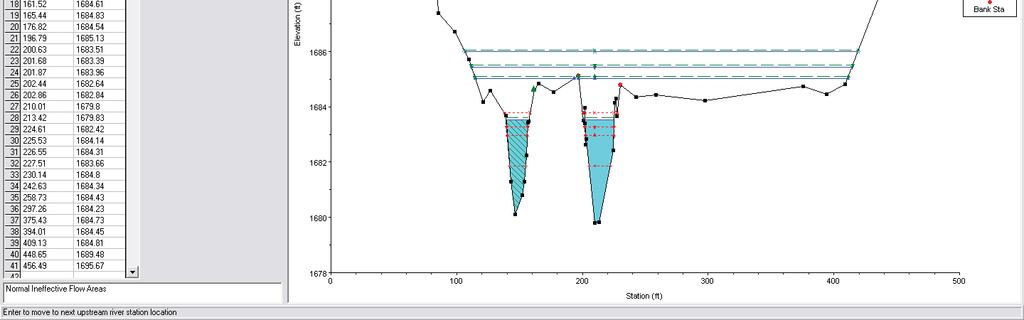
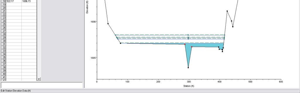
22 Cross Sections Cross sections for the existing and proposed bridge conditions are included.
23 EXISTING CHANNEL
24
25
26
27
28
29
30
31
32
33
34
35
36
37
38 PROPOSED BRIDGE
39
40
41
42
43
44
45
46
47
48
49
50
51
52
53
54
55 APPENDIX F DAMAGE WAVIER


56
57 APPENDIX G FLOW RATE DATA
58 Karisa Falls From: deq-wrd-qreq Sent: Tuesday, November 15, :00 PM To: Karisa Falls Subject: RE: flood or low flow discharge request (ContentID ) Follow Up Flag: Flag Status: Follow up Flagged This reply is being sent via only. We have estimated the flood frequency discharges requested in your of November 8, 2011 (Process No ), as follows: Mulligan Creek at Proposed road 550 feet upstream of east section line, Section 27, T50N, R29W, Michigamme Township, Marquette County, has a drainage area of 2.6 square miles. The 50%, 10%, 2%, 1%, 0.5%, and 0.2% chance peak flows are estimated to be 40 cubic feet per second (cfs), 130 cfs, 260 cfs, 340 cfs, 420 cfs, and 550 cfs, respectively. (Watershed Basin No. 45 Dead). Please include a copy of this letter with your application for permit and indicate whether or not the project is funded under Act 51. These estimates should be confirmed by our office if an application is not submitted within one year. If you have any questions concerning the discharge estimates, please contact Ms. Susan Greiner, Hydrologic Studies and Dam Safety Unit, at or by to GreinerS@michigan.gov. Any questions concerning hydraulic and/or environmental permit issues should be directed to Mr. Jerry Fulcher, Water Resources Division, Transportation and Flood Hazard Management Unit, at or by to FulcherG@michigan.gov. Original Message From: Karisa V. Falls, P.E. [mailto:kfalls@coleman engineering.com] Sent: Tuesday, November 08, :07 PM To: deq wrd qreq Subject: flood or low flow discharge request (ContentID ) Requestor: Karisa V. Falls, P.E. Company: Coleman Engineering Company Address: 635 Circle Drive City: Iron Mountain, MI Zip: Phone: Date: 11/8/2011 F10percent: Yes F2percent: Yes F1percent: Yes F0.5percent: Yes F0.2percent: Yes ContactAgency: None Selected ContactPerson: Watercourse: Mulligan Creek LocalName: CountyLocation: Marquette CityorTownship: Michigamme 1
59 Section: 27 Town: 50N Range: 29W Location: Lat, Long FFR1: County Road Project Content Length:
60 APPENDIX H SITE PHOTOGRAPHS


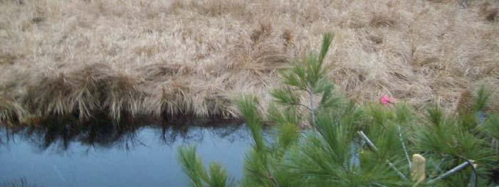
61 River Station 1271 looking northwest upstream at crossing River Station 1271 looking southwest upstream at crossing 1


62 River Station 1289 looking northeast downstream at crossing River Station 1280 looking north at crossing from south bank 2


63 River Station 1280 looking south at crossing from north bank River Station 1289 looking east downstream at crossing standing on south bank 3
64 APPENDIX I USGS QUADRANGLE MAP AND RIVER GRADIENT CALCULATION
65 Proposed Bridge Location Trail 5 Mulligan Creek Stream Slope Calculation: 30 /14467 = or 0.21%
Thirteenth International Water Technology Conference, IWTC , Hurghada, Egypt 1249
 Thirteenth International Water Technology Conference, IWTC 13 2009, Hurghada, Egypt 1249 EVALUATION OF LOCAL SCOUR AROUND BRIDGE PIERS (RIVER NILE BRIDGES AS CASE STUDY) Sherine Ismail Assoc. Prof., Survey
International Osoyoos Lake Board of Control Annual Report to the International Joint Commission
 International Osoyoos Lake Board of Control 2010 Annual Report to the International Joint Commission TABLE OF CONTENTS ACTIVITIES OF THE BOARD... 1 HYDROLOGIC CONDITIONS IN 2010... 2 Drought Criteria...
Version Isolated & Non-Waters Only 1 of 3
 APPROVED JURISDICTIONAL DETERMINATION FORM U.S. Army Corps of Engineers SECTION I: BACKGROUND INFORMATION A. REPORT COMPLETION DATE FOR APPROVED JURISDICTIONAL DETERMINATION (JD): July 6, 2010. B. DISTRICT
HYDROLOGY OF GLACIAL LAKES, FORT SISSETON AREA
 PROC. S.D. ACAD. SCI., VOL. 77 (1998) 59 HYDROLOGY OF GLACIAL LAKES, FORT SISSETON AREA Perry H. Rahn Department of Geology & Geological Engineering South Dakota School of Mines and Technology Rapid City,
FLOW REDUCTION IMPACTS ALONG RIVER NILE IN EGYPT
 FLOW REDUCTION IMPACTS ALONG RIVER NILE IN EGYPT Sherine S. Ismail Prof., Head of Lake Nasser studies department, Nile Research Institute, E-mail:sherine_shawky@yahoo.com ABSTRACT Nile water discharges
c. 1 inch = 0.6 miles e. 1:100,000 f. 1:250,000 f. 1 inch = 4.0 miles
 High School Advance Geology Map Test 2014 Name Use the information on each map to provide the best answer to the questions. Fill in the bubble of the best answer on your answer sheet. Answer questions
Duncan Hastie, P.E. Dewberry
 FEMA s Riverine High Water Marks for Atlanta s September 2009 Flood Event Duncan Hastie, P.E. Dewberry Background High Water Mark Recovery Performed Through FEMA s Hazard Mitigation Technical Assistance
SECTION 3 GENERAL DESCRIPTION OF THE RIVER BASIN
 SECTION 3 GENERAL DESCRIPTION OF THE RIVER BASIN SECTION 3 GENERAL DESCRIPTION OF THE RIVER BASIN River basin description. A general description of the river basin or subbasin, as appropriate, in which
Introduction. The System. Model Limitations, Assumptions, and Parameters. Optional Services Tech Memo
 Optional Services Tech Memo Introduction This technical memo evaluates the impact of a tide gate to be installed at the confluence of the Left Bank Tributary of Thalia Creek and Lake Windsor. Specifically,
GILBERT & WEST TOWN INTERCOUNTY DRAIN Windsor Township, Eaton County and City of Lansing, Delhi Township, Ingham County, Michigan
 GILBERT & WEST TOWN INTERCOUNTY DRAIN Windsor Township, Eaton County and City of Lansing, Delhi Township, Ingham County, Michigan PRELIMINARY ENGINEERING REPORT Abigail Eaton, Chair Intercounty Drains
Final Drainage Letter Pikes Peak Community College Downtown Parking Lot Colorado Springs, Colorado
 Final Drainage Letter Pikes Peak Community College Downtown Parking Lot Colorado Springs, Colorado Prepared for: Pikes Peak Community College 5775 South Academy Boulevard Colorado Springs, CO 80906-5422
Budi Hadi Narendra Harris Herman Siringoringo Chairil Anwar Siregar. Research and Development Center for Forest
 Budi Hadi Narendra Harris Herman Siringoringo Chairil Anwar Siregar Research and Development Center for Forest Background Coastal management should be wisely done as a part of watershed management. Typologically,
HYDRAULIC DESIGN OF THE TOURISTIC BERTHING IN ASWAN CITY
 HYDRAULIC DESIGN OF THE TOURISTIC BERTHING IN ASWAN CITY Dr. Hossam El-Sersawy Researcher, Nile Research Institute (NRI), National Water Research Center (NWRC), Egypt E-mail: h_sersawy@hotmail.com Dr.
Lake Wissota Access Locations within the LaFayette Township. By Chad Martin
 Lake Wissota Access Locations within the LaFayette Township By Chad Martin Anson/ Wissota Access Point # 1 Road: 195 th St. Associated Fire Numbers: 13294 Defining Characteristics: Forested from road
Chapter 4.0 Alternatives Analysis
 Chapter 4.0 Alternatives Analysis Chapter 1 accumulated the baseline of existing airport data, Chapter 2 presented the outlook for the future in terms of operational activity, Chapter 3 defined the facilities
Topographic Maps. Background Sheet
 Topographic Maps History: Background heet The Articles of Confederation (1777) was ratified when western lands were yielded to the Federal Government. This yielding of land gave the Federal Government
Common Ground Drainage Channel Diversion. Design Report
 Common Ground Drainage Channel Diversion Design Report Resource Management International Inc Consulting Engineers May 2017 COMMON GROUND DRAINAGE CHANNEL DIVERSION PREPARED FOR: QUILL LAKES WATERSHED NO.
Wilts & Berks Canal. Appendix E: Hydrology and Hydraulics CONTENTS 1. INTRODUCTION 2 2. HYDROLOGY 2 3. HYDRAULIC MODEL 2 4.
 Wilts & Berks Canal Melksham River Route Study Appendix E: Hydrology and Hydraulics CONTENTS 1. INTRODUCTION 2 2. HYDROLOGY 2 3. HYDRAULIC MODEL 2 4. CANAL OPERATION 3 5. WEIR DESIGN 4 6. FLOOD RISK 5
Composite CN Value Based on Hydrologic Soil Group and Estimated Future Land Cover
 Composite CN Value Based on Hydrologic Soil Group and Estimated Future Land Cover Village of Milan, Mirabal Park /5/016 DEVELOPED LAND AREAS** Basin Basin HSG "B" HSG "C" HSG "D" Basin Basin Area Area
Flood History. Floodplain Descriptions
 Flood History The worst flooding in the area took place in 1966, 1969, 1971, 1995 and 1998. The storms in 1966 and 1969 caused considerable damage throughout the area due to flooding, erosion and debris
Waukegan & Calumet Rivers. All Hands Meeting
 Waukegan & Calumet Rivers 516(e) Update All Hands Meeting David F. Bucaro, P.E. Chief, Economic Formulation & Analysis Section, Planning Branch May 18 th, 2011 Kensington Court Ann Arbor, MI 1 2 Waukegan
Bear Creek Habitat Improvement Project
 06/10/10 Bear Creek Habitat Improvement Project El Paso County, Colorado Pike National Forest and Colorado Springs Utilities Owned Land Report prepared by: Eric Billmeyer Executive Director Rocky Mountain
Appendix A Appendix A (Project Specifications) Auk Auk / Black Diamond (Trail 44) Reroute
 Auk Auk / Black Diamond (Trail 44) Reroute") Appendix A (Project Specifications) Auk Auk / Black Diamond (Trail 44) Reroute I. Proposed Action: This project proposes to reroute approximately 1,800 feet of a 50 inch wide trail, off of private property
Appendix A (Project Specifications) Auk Auk / Black Diamond (Trail 44) Reroute I. Proposed Action: This project proposes to reroute approximately 1,800 feet of a 50 inch wide trail, off of private property
TABLE OF CONTENTS. Coral Springs Charter High School and Middle School Job No Page 2
 Job No. 15-019 Page 2 TABLE OF CONTENTS 1.0 INTRODUCTION... 4 2.0 EXISTING CONDITIONS... 5 3.0 TRAFFIC GENERATION... 7 4.0 TRIP DISTRIBUTION... 8 5.0 FUTURE CONDITIONS... 8 6.0 SITE ACCESS...13 7.0 CONCLUSION...13
Table 1: Iron Mountain Communication Site. Latitude 1 Longitude 1 Elev 2 Address T/R/S 3 APN 4 USGS Quadrangle
 County of Riverside Public Safety Enterprise Communication Project Appendix A: Candidate Site Descriptions Overview The site is located in San Bernardino County near several communication towers in the
Access to the site is obtainable from the paved driveway leading to the MWD facility.
 County of Riverside Public Safety Enterprise Communication Project Appendix A: Candidate Site Descriptions Overview The site is located adjacent to a Metropolitan Water District (MWD) facility on El Sobrante
Natural Factors Affecting the Level of Osoyoos Lake
 Natural Factors Affecting the Level of Osoyoos Lake Background Osoyoos Lake is operated under conditions prescribed by the International Joint Commission (IJC) and Figure 1 shows the ranges within which
BIG HORN RIVER. Big Horn Canal Bluff Fritz Highland Hanover Kirby Lower Hanover Lucerne Tillard Upper Hanover
 BIG HORN RIVER Big Horn Canal Bluff Fritz Highland Hanover Kirby Lower Hanover Lucerne Tillard Upper Hanover DESCRIPTION AND OPERATION MEMORANDUM BIG HORN CANAL USGS ID 4418 D1, 4418 C1, 4417 C8, 4418
David Magney Environmental Consulting
 David Magney Environmental Consulting DELINEATION OF JURISDICTIONAL WATERS AND RIPARIAN HABITATS FOR LYONS CANYON RANCH, NEWHALL, CALIFORNIA Prepared for: UNITED STATES ARMY CORPS OF ENGINEERS and CALIFORNIA
MORGAN CREEK GREENWAY Final Report APPENDICES
 APPENDICES MORGAN CREEK GREENWAY Appendix A Photos of Existing Conditions in Trail Corridor Photos of existing conditions Main trail corridor - February 2009 Photos of existing conditions south bank Morgan
Agenda Report. Spruce Street Outlet Drainage Improvements Tower Road Relief Sewer
 Agenda Report Subject: Prepared By: Spruce Street Outlet Drainage Improvements Tower Road Relief Sewer Steven M. Saunders, Director of Public Works/Village Engineer Date: August 12, 2012 On March 8, 2012
Annual Report to the. International Joint Commission. from the. International Osoyoos Lake Board of Control for
 Annual Report to the International Joint Commission from the International Osoyoos Lake Board of Control for Calendar Year 2005 INTERNATIONAL JOINT COMMISSION International Osoyoos Lake Board of Control
USGS Methods of Collecting High Water Marks (HWMs)
") USGS Methods of Collecting High Water Marks (HWMs) A. Thomas Ruby III Supervisory Hydrologist Indiana-Kentucky Water Science Center U.S. Department of the Interior U.S. Geological Survey Outline: Overview
USGS Methods of Collecting High Water Marks (HWMs) A. Thomas Ruby III Supervisory Hydrologist Indiana-Kentucky Water Science Center U.S. Department of the Interior U.S. Geological Survey Outline: Overview
Introduction. Background MEMORANDUM
 MEMORANDUM Date: July 22, 2014 To: H&H Technical Committee From: Bob Elliot and Larry Karpack, Watershed Science & Engineering Cc: Bob Montgomery, Anchor QEA Re: Chehalis Basin Strategy: Reducing Flood
Enhancing hydrological data management and exchange procedures
 Enhancing hydrological data management and exchange procedures The Sava River Hydraulic Model Dr Mark R Jourdan, PE Research Hydraulic Engineer U.S. Army Engineer Research and Development Center Vicksburg,
Note that the steepest 8 direction pour point model slope in direction 64 is: 10.0
 GIS in Water Resources Exercise #3 Solution Part 1. 1.1 Hand Calculations (i) The standard ESRI surface slope function Grid size 10 m Diagonal distance= 14.142 m 47.5 48 47.7 50.6 48.3 dz/dx= -0.125 45.1
Appendix E. System Issues
 Appendix E System Contents Page System... E-1 E.1 Introduction...E-1 E.2 Existing Model - System...E-2 E.2.1 Location: Country Ridge Collector, at Queensgate Drive...E-2 E.3 Committed Model - System...E-3
II. THE BOULDER CREEK DRAINAGE BASIN
 II. THE BOULDER CREEK DRAINAGE BASIN This section provides an overview of the watersheds and flood hazards associated with Boulder Creek and South Boulder Creek including descriptions of the drainage basins,
Runway Length Analysis Prescott Municipal Airport
 APPENDIX 2 Runway Length Analysis Prescott Municipal Airport May 11, 2009 Version 2 (draft) Table of Contents Introduction... 1-1 Section 1 Purpose & Need... 1-2 Section 2 Design Standards...1-3 Section
Hydrological study for the operation of Aposelemis reservoir Extended abstract
 Hydrological study for the operation of Aposelemis Extended abstract Scope and contents of the study The scope of the study was the analytic and systematic approach of the Aposelemis operation, based on
Design and Construction of the Lake St. Martin Emergency Outlet
 Design and Construction of the Lake St. Martin Emergency Outlet Background 2011 was the largest flood event experienced in the last 200 years Flood Fighting required some difficult decisions by the Manitoba
Boardman River Dams Implementation Team. DRAFT Meeting Minutes
 Location: Traverse City Governmental Center, Commission Chambers 400 Boardman Avenue Traverse City, MI 49684 Boardman River Dams Implementation Team Grand Traverse County Traverse City Light and Power
Preliminary Site Evaluation
 Preliminary Site Evaluation 100 Acre Site, US 72 Piperton, Tennessee Power Distributor: Chickasaw Electric Cooperative August 2010 SITE DATA SHEET PIPERTON US 72 SITE (100 ACRES): LOCATION & GENERAL DESCRIPTION
Photographic Log Client: Project Number: Site Location: Site Name: Photograph ID: Date: Location: Direction: Comments: Photograph ID:
 Photograph ID: 1 west View of one of the monitoring well and the large parking lot on the south side of Center Street. Photograph ID: 2 Monitoring well located in the middle of the parking lot located
Table 1: Margarita (MWD) Communication Site. Latitude 1 Longitude 1 Elev 2 Address T/R/S 3 APN 4 USGS Quadrangle
 Communication Site. Latitude 1 Longitude 1 Elev 2 Address T/R/S 3 APN 4 USGS Quadrangle") County of Riverside Public Safety Enterprise Communication Project Appendix A: Candidate Site Descriptions Margarita (MWD) Communication Site Margarita (MWD) Communication Site Overview The site is located
County of Riverside Public Safety Enterprise Communication Project Appendix A: Candidate Site Descriptions Margarita (MWD) Communication Site Margarita (MWD) Communication Site Overview The site is located
Cofferdam Performance Hurricanes Harvey & Irma
 Cofferdam Performance Hurricanes Harvey & Irma - 2017 Greg Hammer Senior Geotechnical Engineer CELRH-DSPC-GS DSMMCX Third Workshop on Case Histories in Dam Safety Risk-Informed Decision Making 2018 USSD
Trail Feasibility Study
 VOLUSIA COUNTY MPO CITY OF NEW SMYRNA BEACH FINAL REPORT JUNE 30, 2009 Trail Feasibility Study What s inside? 1 Introduction 2 Project Purpose & Scope 3 Physical Inventory & Assessment of Right-of- Way
Hydrology Input for West Souris River IWMP
 Hydrology Input for West Souris River IWMP Prepared by: Mark Lee Manitoba Water Stewardship 1 1 1 Overall view of: drainage area watershed characteristics gauging stations meteorological stations Runoff
APPENDIX D: SUSTAINABLE TRAIL DESIGN. APPENDICES Town of Chili Parks and Recreation Master Plan Update
 APPENDIX D: SUSTAINABLE TRAIL DESIGN APPENDICES Town of Chili Parks and Recreation Master Plan Update Sustainable Trail Construction Sustainable trails are defined by the US Forest Service as trails having
David Johnson. Tom, Attached please find the final scoping letter and figures for your review. David
 David Johnson From: Sent: To: Cc: Subject: Attachments: David Johnson Tuesday, April 12, 2011 4:33 PM Thomas Malecek Dave Dyer; Jason Marks (jmarks@segroup.com) VWC Scoping Letter
LITTLE LOST MAN CREEK (LLM) (formerly USGS Gaging Station No )
 (formerly USGS Gaging Station No )") LITTLE LOST MAN CREEK (LLM) (formerly USGS Gaging Station No. 11482468) LOCATION: In Redwood National and State Park approximately 0.8 miles upstream from confluence with Prairie Creek and 3.2 miles northeast
LITTLE LOST MAN CREEK (LLM) (formerly USGS Gaging Station No. 11482468) LOCATION: In Redwood National and State Park approximately 0.8 miles upstream from confluence with Prairie Creek and 3.2 miles northeast
United States Department of the Interior National Park Service. Boundary Expansion Listed in National Register January 11, 2017
 NPS Form 10900-a (Rev. 8/2002) OMB No. 10240018 United States Department of the Interior National Park Service Boundary Expansion Listed in National Register January 11, 2017 National Register of Historic
Initial OPW Designation APSR AFRR IRR Co-ordinates Easting: Northing: River / Catchment / Sub-catchment Type of Flooding / Flood Risk
 Location: Shannon International Airport, Co. Clare Unique ID: 275484 (from PFRA database) Initial OPW Designation APSR AFRR IRR Co-ordinates Easting: 137674 Northing: 161045 River / Catchment / Sub-catchment
"Transboundary coordination according to the FD Directive in the shared river basins of Greece
 Workshop on Transboundary Issues Budapest March 31st April 1st "Transboundary coordination according to the FD Directive in the shared river basins of Greece Katerina Triantafyllou, ECOS Consulting S.A.
Long term morphological analysis and simulations
 Long term morphological analysis and simulations Dr.-Ing. Markus Promny Bundesanstalt für Gewässerkunde / Federal Institute of Hydrology GESINUS 2010 - Liège - 29./30.07.2010 page 1 1D-models of German
METROPOLITAN COUNCIL 390 North Robert Street, St. Paul, MN Phone (651) TDD (651)
 TDD (651)") DATE: March 27, 2012 METROPOLITAN COUNCIL 390 North Robert Street, St. Paul, MN 55101 Phone (651) 602-1000 TDD (651) 291-0904 TO: Metropolitan Parks and Open Space Commission FROM: Arne Stefferud, Planning
DATE: March 27, 2012 METROPOLITAN COUNCIL 390 North Robert Street, St. Paul, MN 55101 Phone (651) 602-1000 TDD (651) 291-0904 TO: Metropolitan Parks and Open Space Commission FROM: Arne Stefferud, Planning
CENTER PIVOT TRACK MANAGEMENT OPTIONS
 Proceedings of the 28th Annual Central Plains Irrigation Conference, Kearney, Nebraska, February 23-24, 2016 Available from CPIA, 760 N. Thompson, Colby, Kansas CENTER PIVOT TRACK MANAGEMENT OPTIONS Steven
1803 West Hwy 160 Monte Vista, CO (719) TTY (719)
 TTY (719)") USDA Forest Service Rio Grande National Forest http://www.fs.fed.us/r2/riogrande 1803 West Hwy 160 Monte Vista, CO 81144 (719)852-5941 TTY (719)852-6271 USDI Bureau of Land Management San Luis Valley Center
USDA Forest Service Rio Grande National Forest http://www.fs.fed.us/r2/riogrande 1803 West Hwy 160 Monte Vista, CO 81144 (719)852-5941 TTY (719)852-6271 USDI Bureau of Land Management San Luis Valley Center
Figure 1 shows the evaluation area around Tailings Basin Cells 2E/1E. Two areas were evaluated for potential wetland impacts including:
 Barr Engineering Company 4700 West 77th Street Minneapolis, MN 55435-4803 Phone: 952-832-2600 Fax: 952-832-2601 www.barr.com An EEO Employer Minneapolis, MN Hibbing, MN Duluth, MN Ann Arbor, MI Jefferson
Reduction of Wave Runup on a Revetment by Addition of a Berm
 REMR Technical Note CO-RR-1.3 (Supersedes CO-RR-1.3 1986) Reduction of Wave Runup on a Revetment by Addition of a Berm Purpose To provide design guidance for reducing wave runup on a riprap revetment by
CHAPTER 3 ALTERNATIVES CONSIDERED
 CHAPTER 3 ALTERNATIVES CONSIDERED 3.0 ALTERNATIVES The 2010 Stevensville Airport Master Plan contained five (5) airside development options designed to meet projected demands. Each of the options from
GARFIELD BRIDGE. Building A Bridge to No-Where
 GARFIELD BRIDGE Building A Bridge to No-Where OCEANA COUNTY LOCATION Garfield Road leads to Stony Lake Outlet, a Benona Township park and popular Lake Michigan access GARFIELD BRIDGE OVER STONY CREEK
Phoenix Habitat Restoration Projects
 Phoenix Habitat Restoration Projects Spur Cross Ranch Cave Creek (Estergard) Regional Tree and Shade Summit March 9, 2010 Desert Riparian Ecosystems Healthy riparian areas like this once existed along
International Osoyoos Lake Board of Control Annual Report to the International Joint Commission
 International Osoyoos Lake Board of Control 2013 Annual Report to the International Joint Commission TABLE OF CONTENTS ACTIVITIES OF THE BOARD... 1 HYDROLOGIC CONDITIONS IN 2013... 2 Drought Criteria...
Table 1: Glen Avon Communication Site. Latitude 1 Longitude 1 Elev 2 Address T/R/S 3 APN 4 USGS Quadrangle
 County of Riverside Public Safety Enterprise Communication Project Appendix A: Candidate Site Descriptions Overview The site is located on a low ridge of the western Jurupa Mountains adjacent to several
Daisy Dean Trail 628/619 ATV Trail Construction
 Background and Purpose and Need The Daisy Dean ATV Trail Construction Project is located in the Little Belt Mountains, Musselshell Ranger District, Lewis and Clark National Forest approximately 32 miles
Mark West Creek Flow Study Report
 Mark West Creek Flow Study Report Biology and Geology of Mark West Creek The headwaters of Mark West Creek are located in the Mayacamas Mountain range, which border Napa and Sonoma County, where it then
4. Hydrology of the Olentangy River Watershed
 4. Hydrology of the Olentangy River Watershed The Hydrologic Cycle Water on Planet Earth is dynamic constantly being recycled from the land to the atmosphere to the ocean. Rivers and streams are just a
Table 1: Margarita (SDSU) Communication Site. Latitude 1 Longitude 1 Elev 2 Address T/R/S 3 APN 4 USGS Quadrangle
 Communication Site. Latitude 1 Longitude 1 Elev 2 Address T/R/S 3 APN 4 USGS Quadrangle") County of Riverside Public Safety Enterprise Communication Project Appendix A: Candidate Site Descriptions Margarita (SDSU) Communication Site Margarita (SDSU) Communication Site Overview The site is located
County of Riverside Public Safety Enterprise Communication Project Appendix A: Candidate Site Descriptions Margarita (SDSU) Communication Site Margarita (SDSU) Communication Site Overview The site is located
White Oak Creek. Recreational Use Attainability Analysis Summary of Findings. Texas Institute for Applied Environmental Research Stephenville, Texas
 White Oak Creek Recreational Use Attainability Analysis Summary of Findings Texas Institute for Applied Environmental Research Stephenville, Texas August 8, 2016 Sulphur Springs, Texas August 9, 2016 Mount
Finn Creek Park. Management Direction Statement Amendment
 Finn Creek Park Management Direction Statement Amendment November 2013 Management Direction Statement Amendment Approved by: Jeff Leahy Regional Director, Thompson Cariboo BC Parks November 12, 2013 Date
Northeast Stoney Trail In Calgary, Alberta
 aci Acoustical Consultants Inc. 5031 210 Street Edmonton, Alberta, Canada T6M 0A8 Phone: (780) 414-6373, Fax: (780) 414-6376 www.aciacoustical.com Environmental Noise Computer Modelling For Northeast Stoney
International Osoyoos Lake Board of Control Annual Report to the International Joint Commission
 International Osoyoos Lake Board of Control 2015 Annual Report to the International Joint Commission Cover: Northern extent of Osoyoos Lake, where the Okanagan River enters the lake, 2015. View is to the
MINUTES. Additional Stakeholders including CU, CDOT, Town of Erie, and Weld County have been contacted and invited to the recurring progress meetings.
 PROGRESS MEETING BOULDER CREEK MASTER PLAN UDFCD, BOULDER COUNTY, CITIES OF BOULDER & LONGMONT JANUARY 13, 2015 AT 1:00 PM MINUTES 1) ATTENDEES Craig Jacobson, ICON Engineering, Inc. Brian LeDoux, ICON
Citrus Heights Creek Corridor Trail Project. Trail Advisory Group Meeting #3 July 8, 2013
 Citrus Heights Creek Corridor Trail Project Trail Advisory Group Meeting #3 July 8, 2013 Agenda Introductions Recap: Community Workshop, Survey Findings, and TAG Field Trip Community Concern Discussion:
RULES OF TENNESSEE DEPARTMENT OF TRANSPORTATION AERONAUTICS DIVISION CHAPTER LICENSING AND REGISTRATION OF AIRPORTS TABLE OF CONTENTS
 RULES OF TENNESSEE DEPARTMENT OF TRANSPORTATION AERONAUTICS DIVISION CHAPTER 1680-1-2 LICENSING AND REGISTRATION OF AIRPORTS TABLE OF CONTENTS 1680-1-2-.01 Purpose 1680-1-2-.06 Repealed 1680-1-2-.02 Definitions
Miner & Silverstein Appraisal Company Division of Miner & Silverstein, LLP
 Miner & Silverstein Appraisal Company Division of Miner & Silverstein, LLP Marina Market Analysis Upper Connecticut River Marina Market Study Winter 2005-2006 The following presents a winter 2005-06 market
Demand Patterns; Geometric Design of Airfield Prof. Amedeo Odoni
 Demand Patterns; Geometric Design of Airfield Prof. Amedeo Odoni Istanbul Technical University Air Transportation Management M.Sc. Program Airport Planning and Management Module 4 January 2016 Demand Patterns;
Shrubs and alpine meadows represent the only vegetation cover.
 Saldur river General description The study area is the upper Saldur basin (Eastern Italian Alps), whose elevations range from 2150 m a.s.l. (location of the main monitoring site, LSG) and 3738 m a.s.l.
Triangle Land Conservancy Conservation Area Monitoring Report Carolina North
 Triangle Land Conservancy Conservation Area Monitoring Report Carolina North Property Name: Bolin Creek East Conservation Area Date of visit: 4/8/2015 County: Orange Property Type: Restrictive Covenants
Introduction to Topographic Maps
 Introduction to Topographic Maps DIRECTIONS: Read all of the following content. READ EVERYTHING!! At the end of the packet, you will find two topographic maps. Your task is to indentify each of the elevations
Mr. Michael Malone CPS Energy 145 Navarro Street San Antonio, Texas Project No
 January 15, 2016 Mr. Michael Malone 145 Navarro Street San Antonio, Texas 78205 Project No. 0328985 Environmental Resources Management CityCentre Four 840 West Sam Houston Pkwy N. Suite 600 Houston, Texas
HILLSBOROUGH COUNTY, FLORIDA AND INCORPORATED AREAS
 VOLUME 2 OF 5 HILLSBOROUGH COUNTY, FLORIDA AND INCORPORATED AREAS Hillsborough County COMMUNITY NAME COMMUNITY NUMBER HILLSBOROUGH COUNTY (UNINCORPORATED AREAS) 120112 PLANT CITY, CITY OF 120113 TAMPA,
Triangle Land Conservancy Conservation Area Monitoring Report Carolina North
 Triangle Land Conservancy Conservation Area Monitoring Report Carolina North Property Name: Bolin Creek West Conservation Area Date of visit: March 16, 2017 County: Orange Property Type: Restrictive Covenants
Prediction of fluvial processes change within mountain streams on the example of the Porębianka stream
 Prediction of fluvial processes change within mountain streams on the example of the Porębianka stream Andrzej Strużyński*, Maciej Wyrębek*, Małgorzata Leja* Krzysztof Kulesza**, Ilona Biedroń** * University
MANAGING FRESHWATER INFLOWS TO ESTUARIES
 MANAGING FRESHWATER INFLOWS TO ESTUARIES Yuna River Hydrologic Characterization A. Warner Warner, A. (2005). Yuna River Hydrologic Characterization. University Park, Pennsylvania: The Nature Conservancy.
MINUTES OF THE SPECIAL MEETING OF THE LADY LAKE TOWN COMMISSION LADY LAKE, FLORIDA June 20, 2016
 MINUTES OF THE SPECIAL MEETING OF THE LADY LAKE TOWN COMMISSION LADY LAKE, FLORIDA The Special Meeting of the Lady Lake Town Commission was held in the Commission Chambers at Lady Lake Town Hall, 409 Fennell
Climate Change Impact on Water Resources of Pakistan
 Pakistan Water and Power Development Authority (WAPDA) Climate Change Impact on Water Resources of Pakistan Glacier Monitoring & Research Centre Muhammad Arshad Pervez Project Director (GMRC) Outline of
HARBOR INFRASTRUCTURE INVENTORIES Erie Harbor, PA
 HARBOR INFRASTRUCTURE INVENTORIES Erie Harbor, PA Harbor Location: Erie Harbor is located on the southern shore of Lake Erie in the City of Erie, PA about 98 Miles southwest of Buffalo. Authority: River
Table 1: Black Eagle Communication Site. Latitude 1 Longitude 1 Elev 2 Address T/R/S 3 APN 4 USGS Quadrangle
 County of Riverside Public Safety Enterprise Communication Project Appendix A: Candidate Site Descriptions Overview The site is located on a previously graded and benched plateau within the Black Eagle
$6.60 NEW SOUTH WALES. Both METRIC and Feet and Inches TIMES: am/pm Sunrise/Sunset Moon Phases Moon Rise/Set DIARY NOTES.
 $6.60 (incl. GST) 2018 2014 November 28, 2013 November 23, 2017 TO to January 2, 7, 2019 2015 Both METRIC and Feet and Inches TIMES: am/pm Sunrise/Sunset Moon Phases Moon Rise/Set DIARY NOTES NEW SOUTH
State Level Historic Documentation Report. John Blue Bridge Hampshire County
 State Level Historic Documentation Report State Project No. S314-28-22.27 Federal Project No. BR-0028(058)D John Blue Bridge Hampshire County Prepared by: Randy Epperly, Historian Department of Transportation
Development of SH119 BRT Route Pattern Alternatives for Tier 2 - Service Level and BRT Route Pattern Alternatives
 Development of SH119 BRT Route Pattern Alternatives for Tier 2 - Service Level and BRT Route Pattern Alternatives June 1, 2018 Development of SH119 BRT Route Pattern Alternatives for Tier 2 - Service Level
RECREATION. Seven issues were identified that pertain to the effects of travel management on outdoor recreation within portions of the project area.
 RECREATION Seven issues were identified that pertain to the effects of travel management on outdoor recreation within portions of the project area. OPPORTUNITIES FOR SOLITUDE / QUIET TRAILS. One attraction
GLOFs from moraine-dammed lakes: their causes and mechanisms V. Vilímek, A. Emmer
 GLOFs from moraine-dammed lakes: their causes and mechanisms V. Vilímek, A. Emmer Department of Physical Geography and Geoecology, Faculty of Science, Charles University, Prague, Czech Republic vilimek@natur.cuni.cz
Flying Cloud Airport (FCM) Zoning Process: Informing a Mn/DOT Path Forward
 Zoning Process: Informing a Mn/DOT Path Forward") : Informing a Mn/DOT Path Forward A Review of the Flying Cloud Airport (FCM) Joint Airport Zoning Board (JAZB) Process and the Draft Airport Zoning Ordinance B A RPZ RPZ A B C Zone Chad E. Leqve Director
: Informing a Mn/DOT Path Forward A Review of the Flying Cloud Airport (FCM) Joint Airport Zoning Board (JAZB) Process and the Draft Airport Zoning Ordinance B A RPZ RPZ A B C Zone Chad E. Leqve Director
ECLIPSE AIR HEAT BURNERS Series AH-O & TAH-O
 ECLIPSE AIR HEAT BURNERS Series AH-O & TAH-O U.S. Reissue Pat. No. 26,244 Canadian Pat. No. 743,782 Spec 144 11/4/03 AH-O, Front View Data 144-1 AH-O, Back View Data 144-1 TAH-O, Front View Data 144-2
Lake Manitou Dam and Spillway Upgrade
 South Bend Lake Manitou Dam and Spillway Upgrade Fort Wayne Rochester Indiana 1828 to 2017 Lafayette Sky Medors, P.E., LFA David Nance, P.G., IDNR Project Background Location: Rochester Indiana, Central
Section CHAPTER 1 LEGAL STATUS OF WATER COURSES NOVA SCOTIA DEPARTMENT OF NATURAL RESOURCES REGIONAL OFFICES
 Section 17 17.1.1. CHAPTER 1 LEGAL STATUS OF WATER COURSES Environment and Labour The Province of Nova Scotia has possession of all water courses, and the law requires that you obtain approval prior to
Non-motorized Trail Plan & Proposal. August 8, 2014
 Town of Star Valley Ranch, Wyoming and the Star Valley Ranch Association in partnership with the USDA Forest Service, Bridger-Teton National Forest, Greys River Ranger District Non-motorized Trail Plan