STAFF REPORT. Airport Land Use Consistency Determination Betteravia Plaza. MEETING DATE: January 21, 2016 AGENDA ITEM: 8D
|
|
|
- Katrina Horn
- 5 years ago
- Views:
Transcription
 and determine that the project is consistent with the County s Airport Land Use Plan.")
1 STAFF REPORT SUBJECT: Airport Land Use Consistency Determination Betteravia Plaza MEETING DATE: AGENDA ITEM: 8D STAFF CONTACT: Andrew Orfila RECOMMENDATION: Adopt findings for the Betteravia Plaza project (Attachment 1) and determine that the project is consistent with the County s Airport Land Use Plan. SUMMARY: The Betteravia Plaza project is located within the City of Santa Maria near the northeast corner of South Blosser Road and West Betteravia Road, approximately 1.25 miles northeast of the Santa Maria Airport. Since the project involves a General Plan Amendment and rezone, state law requires that the Santa Barbara County Association of Governments (SBCAG), acting as the Airport Land Use Commission, make findings to determine that the project is either consistent, conditionally consistent or inconsistent with the Airport Land Use Plan with respect to land use compatibility, airport safety, height restrictions and noise issues. If the Board fails to act on a consistency determination within 60 days of project submittal, then the project is deemed consistent. The proposed project is a mixed-use development that is currently classified for Light Industrial use in the City s General Plan Land Use Element, and the property is zoned Light Manufacturing, with a Planned Development overlay zone. The proposal is to change the land use classification and to rezone the site to allow up to 285,400 square feet of neighborhood-scale retail commercial use, 75,200 square feet of professional office use, and high-density residential units at a maximum density of 17 dwelling units per acre on approximately acres. Staff recommends that the Board find the project consistent with the Airport Land Use Plan because the project meets all criteria with respect to land use compatibility, airport safety, height restrictions, and noise. The project site is not located in the Clear or Approach Zones of the Santa Maria Airport runway or underneath downwind and base legs or departure paths of frequently used airport traffic patterns at the Santa Maria Airport, meeting Airport Land Use Plan criteria.
2 DISCUSSION: Background State law requires SBCAG, as the designated Airport Land Use Commission (ALUC), to develop and implement an airport land use plan for each general purpose airport. The purpose of the law is to prevent the creation of new noise and safety problems, and to protect public health, safety, and welfare by ensuring the orderly expansion of airports, and the adoption of land use measures that minimize the public s exposure to excessive noise and safety hazards Pub. Util. Code 21670(a). As described in the adopted 1993 Airport Land Use Plan (ALUP) for Santa Barbara County, aircraft overflight exposes individuals in the community to potential hazards associated with aircraft accidents and noise impacts. State statute requires the ALUC to review the adoption, approval or amendment of any General Plan that affects allowable land uses in the Airport Influence Area. Pub. Util. Code 21676(b). The City of Santa Maria Community Development Department referred the proposed Betteravia Plaza project to SBCAG on December 18, 2015 (Attachment 2). SBCAG has 60 days from receipt of the referral to review the project and make its determination. The 60-day Airport Land Use Plan review period ends on March 4, In making its consistency determination, the Board must evaluate the proposed development project against criteria in the adopted Airport Land Use Plan. If the Board fails to act on a consistency determination within 60 days of project submittal, then the project is deemed consistent. Project Description The proposed project contains a mix of land uses on a acre parcel, which is located generally northeast of the intersection of West Betteravia Road and South Blosser Road in the City of Santa Maria. Currently, the site is classified for Light Industrial use in the City s General Plan Land Use Element, and the property is zoned Light Manufacturing, with a Planned Development overlay zone. The proposal is to change the land use classification and to rezone the site to allow the following uses: up to 285,400 square feet of neighborhood-scale retail commercial use on approximately 27.7 acres; up to 64,400 square feet of professional office use on 5.6 acres, and up to 272 high-density residential units at a maximum density of 17 dwelling units per acre on approximately acres. 1 The project site is located within the City of Santa Maria, approximately 1.5 miles west of U.S. 101, 0.5 miles west of State Route 135, and 2 miles south of State Route 166-Main Street. The site is bounded by commercial and industrial uses to the south, east, and west, and planned residential uses and an elementary school to the north. The proposed project is located on Betteravia Road, east of Blosser Road. A portion of the project contains some frontage along Blosser Road, north of Betteravia Road. 1 Draft Environmental Impact Report: Betteravia Plaza General Plan Amendment Land Use and Zone Change Development Agreement, City of Santa Maria, September
3 The request also includes a General Plan Amendment to amend the property s land use designation from Light Industrial (on the entire site) to: Community Commercial (CC) on four parcels Commercial Professional Office (CPO) on two parcels, and High Density Residential (HDR) on two parcels. The Planned Development (PD) overlay zone covers the entire property, and would be retained over the proposed zoning districts to accommodate the uses noted above. More specifically, the proposed General Plan Amendment and Zone Change would change the land use and zoning designations of the site from the current Light Industrial (PD/M-1 zoning) to the following: General Commercial (PD/C-2) Commercial Professional Office (PD/CPO) High Density Residential (PD/R-3) The proposed zoning and conceptual site plan for Betteravia Plaza is shown in Attachment 3. Santa Maria Airport Operations The project site is within the Airport Influence Area (AIA) of the Santa Maria Airport and is located approximately 1.25 miles northeast of the General Aviation Runway 20 end. Approximately 5% of all arrivals and departures to and from Santa Maria Airport occur at Runway Factors in the Consistency Evaluation of Project Components The consistency evaluation of the project with the Airport Land Use Plan is based on four broad criteria: land use compatibility, airport safety, height restrictions, and noise. The following section discusses each of these criteria. Land Use Compatibility: Land use compatibility refers to various types of land uses in the airport vicinity that are compatible and incompatible with airport operation. Determination of land use compatibility is evaluated based on three airport safety areas: Airport Safety Area 1 (Clear Zone), Airport Safety Area 2 (Approach Zone), and Airport Safety Area 3 (Traffic Pattern Zone). Each of these zones provides different levels of land use compatibility due to its relationship with airport operation. Since the Betteravia Plaza project resides within the Traffic Pattern Zone, the following discussion focuses on the land use compatibility criteria in Safety Area 3, which is defined as follows: Safety Area 3 (General) is the area in which airport traffic patterns occur. Traffic patterns vary from airport to airport due to: 1) Runway configuration 2) Prevailing winds 3) Topography 2 Draft Santa Barbara County Airport Land Use Compatibility Plan, pg. A-95. 3
4 4) Population concentration 5) Noise abatement procedures Portions of the general safety area of any airport are frequently overflown and others infrequently overflown. Land use safety recommendations for this area must be more airport-specific than recommendations for clear and safety zones. 3 Airport Safety: This criterion relates to the associated risk and potential consequences resulting from aircraft overflights and accident potential. Regular low-altitude aircraft overflights increase the risk of aircraft accidents. The consistency evaluation focuses on how the risk and consequences of aircraft mishaps could be minimized, if not avoided. Height Restrictions: This criterion focuses on whether or not new structures or obstacles proposed in the clear and approach zones violate the height restrictions as defined in the Federal Aviation Administration (FAA) Federal Aviation Regulation (FAR) Part 77 Objects Affecting Navigable Airspace. Part 77 sets forth criteria in terms of imaginary surfaces to safeguard and preserve navigable airspace. No structures or objects are permitted to penetrate these imaginary surfaces in order to ensure safe passage of aircraft in, and out, and around an airport. Generally, these critical airspaces include the imaginary surface of 50:1 slope for a precision (instrument) approach, the imaginary surface of 34:1 slope for a non-precision approach and the imaginary surface of 20:1 for general aviation runways. Part 77 also stipulates the Transitional Surface of 7:1 slope, rising from both edges of the clear and approach zones on each runway. Obstruction standards and procedure for notification of the FAA prior to construction or alteration of an existing or potential obstruction to navigable airspace are included within FAR Part 77. By definition, any object that penetrates one of the imaginary surfaces is deemed an obstruction to air navigation. However, not all obstructions are necessarily hazards. The determination of whether an object would be a hazard to air navigation is made as part of an aeronautical study conducted by the FAA. 4 The Santa Barbara County Airport Land Use Plan adopts FAA FAR Part 77 height restrictions. According to the Airport Land Use Plan, ALUP height restriction policy shall be: o o To designate height restriction areas for all county airports as laid out in Chapters 4 and 6 of the Airport Land Use Plan; To restrict the development of new incompatible land uses with airport height restriction areas which penetrate FAR Part 77 surfaces; 3 Airport Land Use Plan, pgs California Airport Land Use Planning Handbook, Caltrans Division of Aeronautics, October 2011, p
5 o To review any specific projects within the Airport Influence Area which may pose an intrusion into navigable airspace. 5 Runway 20 at the Santa Maria Airport is a general aviation runway with a visual approach at a 20:1 approach slope. Noise: Airport noise is an important consistency evaluation criterion. The Airport Land Use Plan noise criterion assures that new land uses proposed in airport environs are compatible with aircraft-generated noise. The Airport Noise Area is determined by using the California Airport Noise Standard which sets forth the criterion Community Noise Equivalent Level (CNEL). The Airport Land Use Plan has adopted policies for specific land use types within the 60 and 65 decibel (db) CNEL noise contours. Generally, the project evaluation is based on the noise contours from the existing Airport Land Use Plan at the Santa Maria Airport. The Airport Noise Area extent is based on anticipated airport operations over the next 20 years and unanticipated changes in operations may require new noise measurement and redefinition of the airport noise zone. Consistency Analysis The project site plan and associated land uses are shown in Attachment 3. The project site is located approximately 1.25 miles northeast of the end of Runway 20. Land Use Compatibility The project site would contain a mix of land uses; including up to 285,400 square feet of neighborhood-scale retail commercial use (on 27.7 acres), up to 64,400 square feet of professional office use (5.6 acres), and up to 272 high-density residential units at a maximum density of 17 dwelling units per acre on approximately acres. 6 According to Table 4-1 of the Airport Land Use Plan, all of the land uses on-site are compatible land uses in Safety Area 3 as long as they do not result in large concentrations of people underneath downwind and base legs or departure paths of frequently used airport traffic patterns. Attachment 4 indicates that the project site is not located under downwind and base legs or departure paths of frequently used airport traffic patterns at the Santa Maria Airport. Therefore, staff recommends that the ALUC find that the project land uses are consistent with the land use compatibility criteria in the Airport Land Use Plan. Airport Safety Airport safety primarily relates to the associated risk resulting from aircraft overflights and accident potential. Regular low-altitude aircraft overflights increase the potential for aircraft 5 Airport Land Use Plan Chapter 2, Chapter 5, p Draft Environmental Impact Report: Betteravia Plaza General Plan Amendment Land Use and Zone Change Development Agreement, City of Santa Maria, September
6 accidents. Therefore, the consistency evaluation focuses on the location and possible effects on the project site, and how the risk and consequences of aircraft accidents could be minimized. As outlined in the previous section and illustrated on Attachment 4, because the project site does not reside underneath downwind and base legs or departure paths of frequently used airport traffic patterns at the Santa Maria Airport, associated risk from aircraft overflights at the project site would be minimal. Therefore, staff recommends that the project be found consistent with the safety criteria in the Airport Land Use Plan. Height Restrictions As noted previously, the project site is located approximately 1.25 miles from the edge of Runway 20 at Santa Maria Airport. Runway 20 is a general aviation runway with a visual approach at a 20:1 approach slope. The height restrictions for the site according to the calculations in the Airport Land Use Plan and FAR Part 77 are shown below: Height Restriction: 6,600 / 20 = 330 The Betteravia Plaza EIR states that the proposed buildings on-site would not exceed four stories in height, therefore, staff recommends that the ALUC find that the project is consistent with the height criteria in the Airport Land Use Plan. Noise As shown in Attachment 5, the project site is located outside of the 60 db CNEL contour. The Airport Land Use Plan states: Within the boundaries of the 60 (db) CNEL contour as projected in the Airport Land Use Plan, residential land uses may be permitted subject to an acoustical analysis showing that all structures have been designed to limit interior noise levels in any habitable room to 45 db CNEL. 7 Since there are no residences or other habitable land uses within the 60 db CNEL contour, staff recommends that the ALUC find that the project is consistent with the noise policy in the Airport Land Use Plan. Disclosure Requirement Aircraft Overflight Assembly Bill 2776, which was passed in 2002 and took effect January 1, 2004, requires any person selling property within an Airport Influence Area to file a report with the Department of Real Estate stating that said property is located within the Airport Influence Area. The purpose of overflight notification is to increase buyer awareness and ensure that prospective buyers of property near an airport, particularly residential property, are informed about the airport s potential impacts prior to purchase. The project site is located within the Airport Influence Area for the Santa Maria Airport. Since the project site is located within the Airport Influence Area, State law mandates the following notice be recorded in the property s chain of title: 7 Airport Land Use Plan, Chapter 5, p
7 NOTICE OF AIRPORT IN VICINITY This property is presently located in the vicinity of an airport, within what is known as an airport influence area. For that reason, the property may be subject to some of the annoyances or inconveniences associated with proximity to airport operations (for example: noise, vibration, or odors). Individual sensitivities to those annoyances can vary from person to person. You may wish to consider what airport annoyances, if any, are associated with the property before you complete your purchase and determine whether they are acceptable to you. In order to remain consistent with State law, staff recommends that the ALUC consider a recommendation to the Santa Maria City Council for placing a Notice of Airport in Vicinity condition on the project for the residential units associated with the project. INPUT FROM OTHER AGENCIES: On December 18, 2015 SBCAG received the City of Santa Maria s referral for determination of consistency with the Airport Land Use Plan (Attachment 2). Since then, SBCAG staff has discussed the project with City staff via phone. RECOMMENDATION: Based on the project s location, land use compatibility and aircraft safety, staff recommends that the Board find that the Betteravia Plaza project is consistent with the Airport Land Use Plan. Proposed findings supporting this determination of consistency are included in Attachment 1. ATTACHMENTS: 1. Findings 2. Referral from City of Santa Maria Community Development Department 3. Project Site Map 4. Project Site Location With Airport Land Use Plan Safety Overlay and Arrival / Departure Flight Paths To / From Santa Maria Airport 5. Project Site Location With Airport Noise Contours Overlay 7
8 ATTACHMENT 1: FINDINGS 1. The Betteravia Plaza project, which is located generally northeast of the intersection of West Betteravia Road and South Blosser Road, proposes a mix of land uses on the acre site consisting of up to: 285,400 square feet of neighborhood-scale retail commercial use on approximately 27.7 acres; 64,400 square feet of professional office use on 5.6 acres, and 272 high-density residential units at a maximum density of 17 dwelling units per acre on approximately acres. 2. The project involves a General Plan Amendment and Rezone from Light Industrial to a mixture of Community Commercial (CC) with a General Commercial (PD/C-2) zoning designation, Commercial Professional Office (CPO) with Commercial Professional Office (PD/CPO) zoning and High Density Residential (HDR) with High Density Residential (PD/R- 3) Zoning. The existing Planned Development zoning overlay on the site would be retained. 3. The project site is within the Airport Influence Area (AIA) of the Santa Maria Airport and is located approximately 1.25 miles from the end of Runway The entire project site is located within the General Traffic Pattern Area of the Santa Maria Airport, outside of the clear and approach zones. The project site is not located in the Clear or Approach Zones of the Santa Maria Airport runway or underneath downwind and base legs or departure paths of frequently used airport traffic patterns at the Santa Maria Airport. Therefore, the project is consistent with the land use compatibility and safety criteria in the Airport Land Use Plan. 5. Since all of the buildings located on the project site (four stories or less) would not exceed the height restrictions applicable to the project site in the Airport Land Use Plan (330 feet), the project is compatible with the height criteria in the Airport Land Use Plan. 6. There would be no habitable structures located within the 60 dba Community Noise Equivalent Level (CNEL) noise contour of Runway 20 at the Santa Maria Airport as a result of the project. Therefore, the project is consistent with the noise policies in the Airport Land Use Plan. 7. The project site is located within the Airport Influence Area for the Santa Maria Airport. Since the project site is located within the Airport Influence Area, State Law mandates the following notice be recorded in the residential property s chain of title: NOTICE OF AIRPORT IN VICINITY This property is presently located in the vicinity of an airport, within what is known as an airport influence area. For that reason, the property may be subject to some of the annoyances or inconveniences associated with proximity to airport operations (for example: noise, vibration, or odors). Individual sensitivities to those annoyances can vary from person to person. You may wish to consider what airport annoyances, if any, are associated with the property before you complete your purchase and determine whether they are acceptable to you. 8
9 ATTACHMENT 2: REFERRAL LETTER 9
10 10

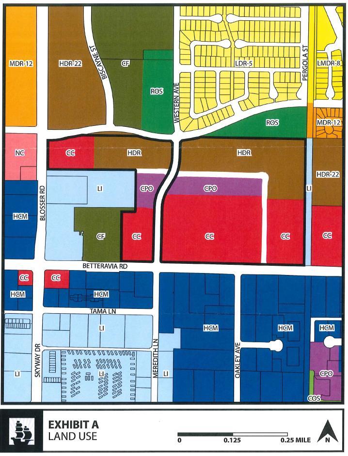
11 Source: Betteravia Plaza EIR ATTACHMENT 3 PROJECT SITE MAP

12 ATTACHMENT 4 - PROJECT SITE LOCATION WITH AIRPORT LAND USE PLAN SAFETY OVERLAY AND ARRIVAL / DEPARTURE FLIGHT PATHS TO / FROM SANTA MARIA AIRPORT

13 ATTACHMENT 5 PROJECT SITE LOCATION WITH AIRPORT NOISE CONTOURS OVERLAY
14
STAFF REPORT. Airport Land Use Plan Consistency Review: Old Town Village Mixed Use Project City of Goleta. MEETING DATE: June 18, 2015 AGENDA ITEM: 5M
 STAFF REPORT SUBJECT: Airport Land Use Plan Consistency Review: Old Town Village Mixed Use Project City of Goleta MEETING DATE: AGENDA ITEM: 5M STAFF CONTACT: Peter Imhof, Andrew Orfila RECOMMENDATION:
STAFF REPORT. Airport Land Use Plan Consistency Review: Santa Barbara Airport Master Plan. MEETING DATE: November 19, 2015 AGENDA ITEM: 7D
 STAFF REPORT SUBJECT: Airport Land Use Plan Consistency Review: Santa Barbara Airport Master Plan MEETING DATE: AGENDA ITEM: 7D STAFF CONTACT: Peter Imhof, Andrew Orfila RECOMMENDATION: Adopt findings
APPENDIX K LAND USE. Charles M. Schulz - Sonoma County Airport Draft Environmental Impact Report July 2011 K-1
 APPENDIX K LAND USE Charles M. Schulz - Sonoma County Airport Draft Environmental Impact Report July 2011 K-1 Appendix K Land Use THIS PAGE INTENTIONALLY LEFT BLANK Charles M. Schulz - Sonoma County Airport
Notice of Extended Comment Period for an Intent to Adopt a Negative Declaration
 County of Santa Clara Department of Planning and Development Planning Office County Government Center, East Wing, 7 th Floor 70 West Hedding Street San Jose, California 95110-1705 (408) 299-5770 FAX (408)
CHAPTER 6 NOISE EXPOSURE
 CHAPTER 6 NOISE EXPOSURE FAA requires that the NEM submitted for review represent the aircraft noise exposure for the year of submittal (in this case 2008) and for a future year (2013 for OSUA). However,
City of Upland, California September 2014 Draft
 Cable Airport Land Use Compatibility Plan City of Upland, California September 2014 Draft Cable Airport Land Use Compatibility Plan September 2014 Draft Prepared for City of Upland, California Prepared
Butte County. Airport land use. compatibility plan OROVILLE MUNICIPAL, CHICO MUNICIPAL, RANCHAERO AIRPORTS PARADISE AND
 CHICO MUNICIPAL, OROVILLE MUNICIPAL, PARADISE AND RANCHAERO AIRPORTS Butte County Airport land use compatibility plan Prepared for the BUTTE COUNTY AIRPORT LAND USE COMMISSION Adopted November 15, 2017
The following criteria shall be applied within the boundaries of the AO District:
 Sec. 419 (a) Purpose AIRPORT OVERLAY DISTRICT (AO) The purpose of the Airport Overlay District is to regulate and restrict the height of structures, objects, or natural growth, regulate the locations of
Beale Air Force Base Land Use Compatibility Plan
 Beale Air Force Base Land Use Compatibility Plan Airport Land Use Commission for Sacramento, Sutter, Yolo, and Yuba Counties Sacramento Area Council of Governments Yuba County, California September 2010
 Brown Field Municipal Airport Land Use Compatibility Plan San Diego County Regional Airport Authority Brown Field Municipal Airport Land Use Compatibility Plan Prepared for: San Diego County Regional
Appendices. Merced County Airport Land Use Compatibility Plan
 Appendices Merced County Airport Land Use Compatibility Plan A P P E N D I X A Foundations of Airport Land Use Compatibility Planning INTRODUCTION This appendix outlines the policy foundations upon which
Airport Land Use Compatibility Plan (ALUCP) Update. Public Information Meeting #4 June 8 & 9, 2016
 Update. Public Information Meeting #4 June 8 & 9, 2016") Airport Land Use Compatibility Plan (ALUCP) Update Public Information Meeting #4 June 8 & 9, 2016 Agenda 1. Study Process 2. Noise Complaint Patterns 3. Proposed Overflight Areas (AOA) 4. Proposed Land
Airport Land Use Compatibility Plan (ALUCP) Update Public Information Meeting #4 June 8 & 9, 2016 Agenda 1. Study Process 2. Noise Complaint Patterns 3. Proposed Overflight Areas (AOA) 4. Proposed Land
Background Data: Blue Canyon Airport and Environs
 5 Background Data: and Environs INTRODUCTION serves as an important emergency landing field amid mountainous terrain. The airport has existed on the site since the 1930s or 40s. The facility was operated
Appendix C AIRPORT LAYOUT PLANS
 Appendix C AIRPORT LAYOUT PLANS Appendix C AIRPORT LAYOUT PLANS Airport Master Plan Santa Barbara Airport As part of this Airport Master Plan, the Federal Aviation Administration (FAA) requires the development
Comparison Between Old and New ALUC Plans
 A P P E N I X H Comparison Between Old and New ALUC Plans OVERVIEW This Placer County Airport Land Use Compatibility Plan (ALUCP) sets forth land use compatibility criteria for the environs of Auburn Municipal,
Welcome to Public Information Workshop 1. San Francisco International Airport FAR Part 150 Study Update Noise Exposure Map Report
 Welcome to Public Information Workshop 1 Chetcuti Room, City of Milbrae 450 Poplar Avenue Milbrae, California 94030 Wednesday, June 4, 2014 5:45 p.m. to 6:45 p.m. PDT The FAA typically uses the airport
AIRPORT LAND USE COMPATILIBILTY AIRPORT LAND USE COMPATIBILIITY
 CHAPTER 7 AIRPORT LAND USE COMPATILIBILTY CHAPTER 7 AIRPORT LAND USE COMPATIBILIITY 7.0 INTRODUCTION On airport aviation related development is typically compatible with aircraft operations. On airport
LAX Community Noise Roundtable. Aircraft Noise 101. November 12, 2014
 LAX Community Noise Roundtable Aircraft Noise 101 November 12, 2014 Overview Roles and Responsibilities for Aircraft Noise Relevant Federal Regulations Relevant California Regulations Aircraft Noise Metrics
Airport Protection Area
 APPENDIX H Airport Protection Area The Airport Land Use Commission of Alameda County Hayward, California Resolution 93-01 At a meeting held January 13, 1993 Introduced by Commissioner Maestas Seconded
Flying Cloud Airport (FCM) Zoning Process: Informing a Mn/DOT Path Forward
 Zoning Process: Informing a Mn/DOT Path Forward") : Informing a Mn/DOT Path Forward A Review of the Flying Cloud Airport (FCM) Joint Airport Zoning Board (JAZB) Process and the Draft Airport Zoning Ordinance B A RPZ RPZ A B C Zone Chad E. Leqve Director
: Informing a Mn/DOT Path Forward A Review of the Flying Cloud Airport (FCM) Joint Airport Zoning Board (JAZB) Process and the Draft Airport Zoning Ordinance B A RPZ RPZ A B C Zone Chad E. Leqve Director
ARTICLE 34 AIRPORT HEIGHT COMBINING ZONE (AH) (Amended by Ordinance #295 Effective June 26, 2009)
 (Amended by Ordinance #295 Effective June 26, 2009)") ARTICLE 34 AIRPORT HEIGHT COMBINING ZONE (AH) (Amended by Ordinance #295 Effective June 26, 2009) Section 34.10 - Purpose and Intent The purpose of the Airport Height Combining Zone (AH) is to protect
ARTICLE 34 AIRPORT HEIGHT COMBINING ZONE (AH) (Amended by Ordinance #295 Effective June 26, 2009) Section 34.10 - Purpose and Intent The purpose of the Airport Height Combining Zone (AH) is to protect
Reliever Airports: NOISE ABATEMENT PLAN Flying Cloud Airport (FCM)
") Reliever Airports: NOISE ABATEMENT PLAN Flying Cloud Airport (FCM) INTRODUCTION The Noise Abatement Plan (FCM Plan) for the Flying Cloud Airport has been prepared in recognition of the need to make the
Reliever Airports: NOISE ABATEMENT PLAN Flying Cloud Airport (FCM) INTRODUCTION The Noise Abatement Plan (FCM Plan) for the Flying Cloud Airport has been prepared in recognition of the need to make the
St. Paul Downtown Airport (STP)
") Reliever Airports: NOISE ABATEMENT PLAN St. Paul Downtown Airport (STP) 1 INTRODUCTION The noise abatement plan for the St. Paul Downtown Airport (STP) was prepared in recognition of the need to make the
Reliever Airports: NOISE ABATEMENT PLAN St. Paul Downtown Airport (STP) 1 INTRODUCTION The noise abatement plan for the St. Paul Downtown Airport (STP) was prepared in recognition of the need to make the
Airport Background Data and Assumptions Report New Cuyama Airport. Santa Barbara County Airport Land Use Compatibility Plan Update
 Airport Background Data and Assumptions Report Santa Barbara County Airport Land Use Compatibility Plan Update June 25, 212 Updated August 17, 217 Airport Background Data and Assumptions Report 1. Introduction
Chapter 1. Introduction. Placer County Airport Land Use Compatibility Plan
 Chapter 1 Introduction Placer County Airport Land Use Compatibility Plan 1 Introduction OVERVIEW This Placer County Airport Land Use Compatibility Plan (ALUCP) contains the individual Compatibility Plan
Chapter Six ALP Drawings. Tacoma Narrows Airport. Master Plan Update
 Chapter Six ALP Drawings Master Plan Update The master planning process for the (Airport) has evolved through efforts in the previous chapters to analyze future aviation demand, establish airside and landside
at: Accessed May 4, 2011.
 3.11 SAFETY 3.11.1 Background and Methodology As with other forms of transportation, there is risk associated with aviation activities. This section focuses on risk to those on the ground near airports.
Airport Land Use Commission AIRPORT ENVIRONS. LAND USE PLAN for JOHN WAYNE AIRPORT
 Airport Land Use Commission AIRPORT ENVIRONS LAND USE PLAN for JOHN WAYNE AIRPORT Amended: April 17, 2008 AIRPORT ENVIRONS LAND USE PLAN April 17, 2008 Text of Plan Adopted April 17, 1975 Marine Corps
THE BURBANK-GLENDALE-PASADENA AIRPORT AUTHORITY S UPDATE REGARDING ITS NOISE IMPACT AREA REDUCTION PLAN AND ITS PART 161 STUDY SECOND QUARTER 2015
 THE BURBANK-GLENDALE-PASADENA AIRPORT AUTHORITY S UPDATE REGARDING ITS NOISE IMPACT AREA REDUCTION PLAN AND ITS PART 161 STUDY SECOND QUARTER 2015 Pursuant to the California Department of Transportation
Memorandum. Federal Aviation Administration. Date: June 19, Richard Doucette, Environmental Protection Specialist. From: To:
 Federal Aviation Administration Memorandum Date: June 19, 2008 From: To: Subject: Richard Doucette, Environmental Protection Specialist LaVerne Reid, Airports Division Manager John Donnelly, Regional Counsel
NOTICE TO PROPOSED CITY PERMITS: ZONING HEIGHT RESTRICTIONS/APPROVAL PROCESS
 NOTICE TO PROPOSED CITY PERMITS: ZONING HEIGHT RESTRICTIONS/APPROVAL PROCESS Dear Prospective Permittee: The City of St Petersburg (City) issues permits for construction projects based on local and state
THE BURBANK-GLENDALE-PASADENA AIRPORT AUTHORITY S UPDATE REGARDING ITS NOISE IMPACT AREA REDUCTION PLAN AND ITS PART 161 STUDY FIRST QUARTER 2015
 THE BURBANK-GLENDALE-PASADENA AIRPORT AUTHORITY S UPDATE REGARDING ITS NOISE IMPACT AREA REDUCTION PLAN AND ITS PART 161 STUDY FIRST QUARTER 2015 Pursuant to the California Department of Transportation
THE BURBANK-GLENDALE-PASADENA AIRPORT AUTHORITY S UPDATE REGARDING ITS NOISE IMPACT AREA REDUCTION PLAN AND ITS PART 161 STUDY SECOND QUARTER 2017
 THE BURBANK-GLENDALE-PASADENA AIRPORT AUTHORITY S UPDATE REGARDING ITS NOISE IMPACT AREA REDUCTION PLAN AND ITS PART 161 STUDY SECOND QUARTER 2017 Pursuant to the California Department of Transportation
NEGATIVE DECLARATION. NAME OF PROJECT: Fresno County Airport Land Use Compatibility Plan (ALUCP)
") Negative Declaration Fresno County ALUCP December 3, 2018 NEGATIVE DECLARATION The Fresno County Airport Land Use Commission (ALUC) has reviewed the proposed project described below to determine whether
Negative Declaration Fresno County ALUCP December 3, 2018 NEGATIVE DECLARATION The Fresno County Airport Land Use Commission (ALUC) has reviewed the proposed project described below to determine whether
PLAN Anoka County - Blaine Airport
 Reliever Airports: NOISE ABATEMENT PLAN Anoka County - Blaine Airport INTRODUCTION The noise abatement plan for the Anoka County-Blaine Airport was prepared in recognition of the need to make the airport
FRENCH VALLEY AIRPORT (F70) Sky Canyon Dr. Murrieta, CA. Phone: Riverside FAA FSDO Complaint Line: (951)
 Sky Canyon Dr. Murrieta, CA. Phone: Riverside FAA FSDO Complaint Line: (951)") FRENCH VALLEY AIRPORT (F70) 37600 Sky Canyon Dr. Murrieta, CA Phone: 951-600-7297 Riverside FAA FSDO Complaint Line: (951) 276-6701 Visit the F70 website for additional information regarding the airport
FRENCH VALLEY AIRPORT (F70) 37600 Sky Canyon Dr. Murrieta, CA Phone: 951-600-7297 Riverside FAA FSDO Complaint Line: (951) 276-6701 Visit the F70 website for additional information regarding the airport
Santa Barbara County Airport Land Use Compatibility Plan Update. February 6, 2017
 Santa Barbara County Airport Land Use Compatibility Plan Update February 6, 2017 1 Welcome Santa Maria Public Airport New Cuyama Airport Vandenberg Air Force Base Lompoc Airport Santa Ynez Valley Airport
Finance and Implementation
 5 Finance and Implementation IMPLEMENTATION The previous chapters have presented discussions and plans for development of the airfield, terminal, and building areas at Sonoma County Airport. This chapter
AIR TRANSPORTATION ELEMENT
 AIR TRANSPORTATION ELEMENT Sonoma County Permit and Resource Management Department 2550 Ventura Avenue Santa Rosa, CA 95403 Adopted by Resolution No. 08-0808 of the Sonoma County Board of Supervisors September
Airport Land Use Commission. AIRPORT ENVIRONS LAND USE PLAN for FULLERTON MUNICIPAL AIRPORT
 Airport Land Use Commission AIRPORT ENVIRONS LAND USE PLAN for FULLERTON MUNICIPAL AIRPORT Amended: November 18, 2004 AIRPORT ENVIRONS LAND USE PLAN November 18, 2004 Text of Plan Adopted April 17, 1975
Background Data: Blue Canyon Airport and Environs
 Chapter 8 Background ata: and Environs Placer County Airport Land Use Compatibility Plan 8 Background ata: and Environs INTROUCTION serves as an important emergency landing field amid mountainous terrain.
COMPREHENSIVE LAND USE PLAN SANTA CLARA COUNTY PALO ALTO AIRPORT
 COMPREHENSIVE LAND USE PLAN SANTA CLARA COUNTY PALO ALTO AIRPORT ADOPTED By the SANTA CLARA COUNTY AIRPORT LAND USE COMMISSION San Jose, California November 19, 2008 Prepared by Walter B. Windus, PE Aviation
Overview ICAO Standards and Recommended Practices for Aerodrome Safeguarding
 Overview ICAO Standards and Recommended Practices for Aerodrome Safeguarding References The Convention on International Civil Aviation (Chicago Convention) ICAO SARPS Annex 14 Vol. I, 7 th Edition, July
ORDINANCE NO. _2013-
 ORDINANCE NO. _2013- AN ORDINANCE OF THE TOWNSHIP OF CONEWAGO, DAUPHIN COUNTY, PENNSYLVANIA, PROVIDING FOR AIRPORT ZONING REGULATIONS WITHIN THE AIRPORT ZONING OVERLAY DISTRICT CREATED BY THIS ORDINANCE
Lincoln Regional Airport Compatibility Policies and Maps
 Chapter 6 Lincoln Regional Airport Compatibility Policies and Maps Placer County Airport Land Use Compatibility Plan 6 Lincoln Regional Airport Compatibility Policies and Maps 6.1. Evaluating Land Use
WELCOME! FORT LAUDERDALE-HOLLYWOOD INTERNATIONAL AIRPORT 14 CFR PART 150 NOISE AND LAND USE COMPATIBILITY STUDY
 WELCOME! FORT LAUDERDALE-HOLLYWOOD INTERNATIONAL AIRPORT 14 CFR PART 150 NOISE AND LAND USE COMPATIBILITY STUDY Public Information Workshop November 2017 1 14 CFR Part 150 Overview Establishes the methodology
Boise Municipal Code. Chapter DEFINITIONS
 Chapter 12-03 DEFINITIONS Sections: 12-03-01 ADMINISTRATOR 12-03-02 AIRPORT DESIGNATIONS 12-03-03 AIRPORT HAZARD 12-03-04 AIRPORT HEIGHT LIMITATIONS 12-03-05 AIRPORT REFERENCE POINT 12-03-06 AIRPORT INSTRUMENT
Washington Dulles International Airport (IAD) Aircraft Noise Contour Map Update
 Aircraft Noise Contour Map Update") Washington Dulles International Airport (IAD) Aircraft Noise Contour Map Update Ultimate ASV, Runway Use and Flight Tracks 4th Working Group Briefing 8/13/18 Meeting Purpose Discuss Public Workshop input
Washington Dulles International Airport (IAD) Aircraft Noise Contour Map Update Ultimate ASV, Runway Use and Flight Tracks 4th Working Group Briefing 8/13/18 Meeting Purpose Discuss Public Workshop input
Portable Noise Monitor Report
 Portable Noise Monitor Report Chicago O Hare International Airport Site 2198 5N67 Rochefort Lane, Wayne May 9, 218 through June 3, 218 USH6-ILH49-ILS25 Visit the O Hare Noise webpage on the Internet at
Martin Pastucha, Director of Public Works/Airport Director
 Information Item Date: September 3, 2015 To: From: Subject: Mayor and City Council Martin Pastucha, Director of Public Works/Airport Director City s Response and Airport Commission s Recommendations to
Buchanan Field. Airport Planning Program. FAR Part 150 Meeting. September 28, Master Plan FAR Part 150 Noise Study Strategic Business Plan
 Airport Planning Program Master Plan FAR Part 150 ise Study Strategic Business Plan FAR Part 150 Meeting September 28, 2006 Agenda Introduction Part 150 Study Working Paper Two Operational Alternatives
Portable Noise Monitor Report
 Portable Noise Monitor Report Chicago O Hare International Airport Site 2117 5843 N. Christiana Avenue, Chicago July 14, 217 through August 2, 217 USH5-ILH15-ILS8-CHI39 Visit the O Hare Noise webpage on
Airport Obstruction Standards
 Airport Obstruction Standards Dr. Antonio Trani Department of Civil and Environmental Engineering Virginia Tech Outline of this Presentation Obstructions to navigation around airports Discussion of Federal
AIRSPACE PROTECTION. Guidance and considerations for development in the vicinity of Ohio s airports and heliports
 AIRSPACE PROTECTION Guidance and considerations for development in the vicinity of Ohio s airports and heliports UPDATED SPRING 2018 AIRSPACE PROTECTION When construction is proposed near public use airports
APPENDIX F. FAA and Orange County ALUC References
 APPENDIX F FAA and Orange County ALUC References Mail Processing Center Federal Aviation Administration Southwest Regional Office Obstruction Evaluation Group 2601 Meacham Boulevard Fort Worth, TX 76193
ACTION TRANSMITTAL
 Transportation Advisory Board of the Metropolitan Council of the Twin Cities ACTION TRANSMITTAL 2018-16 DATE: February 9, 2018 TO: Transportation Advisory Board FROM: Technical Advisory Committee PREPARED
DRAFT MASTER PLAN UPDATE
 DRAFT MASTER PLAN UPDATE CHAPTER VI: AIRPORT LAYOUT PLAN NARRATIVE DRAFT REPORT APRIL 2017 PREPARED BY: Table of Contents WESTCHESTER COUNTY AIRPORT 6 AIRPORT LAYOUT PLAN NARRATIVE REPORT... 6-1 6.1 AGIS
SAN FRANCISCO INTERNATIONAL AIRPORT CITY & COUNTY OF SAN FRANCISCO MEMORANDUM
 SAN FRANCISCO INTERNATIONAL AIRPORT CITY & COUNTY OF SAN FRANCISCO MEMORANDUM TO: MONTARA COMMUNITY FROM: SAN FRANCISCO INTERNATIONAL AIRPORT AIRCRAFT NOISE ABATEMENT OFFICE SUBJECT: MONTARA SHORT-TERM
Federal Aviation Administration DCA. By: Terry Biggio, Vice President Air Traffic Services Date: June 18, Federal Aviation Administration
 DCA Presented to: Arlington County By: Terry Biggio, Vice President Air Traffic Services Date: June 18, 2015 Air Traffic Roles and Responsibilities As aviation technology advances, the FAA is putting in
Airport Land Use Compatibility Plan (ALUCP) Update. Public Information Meeting #2 December 1, 2015
 Update. Public Information Meeting #2 December 1, 2015") Airport Land Use Compatibility Plan (ALUCP) Update Public Information Meeting #2 December 1, 2015 Agenda 1. Welcome and Introductions 2. Status of Study 3. Long-term Planning Activity Level Annual Service
Airport Land Use Compatibility Plan (ALUCP) Update Public Information Meeting #2 December 1, 2015 Agenda 1. Welcome and Introductions 2. Status of Study 3. Long-term Planning Activity Level Annual Service
FAA Requirements for Engine-out Procedures and Obstacle Clearance
 FAA Requirements for Engine-out Procedures and Obstacle Clearance Presentation to: CAAC Engine-out Procedures Seminar Name: Chuck Friesenhahn Date: 11/29/2005 Flight Standards Senior Advisor, Advanced
PLANNING AND ZONING MEETING. March 20, 2019 AGENDA. 1. Review Minutes. 1
 PLANNING AND ZONING MEETING March 20, 2019 AGENDA 1. Review Minutes. 1 2. Appointments A. Land Use Map Discussion Horrocks Engineers.. 2 B. Airport Protection Ordinance. 3-8 3. Other Business 4. Adjourn
It is essential that planning take full account of air safety and efficiency of operations.
 Airspace Protection Airspace Protection It is essential that planning take full account of air safety and efficiency of operations. 7.1 INTRODUCTION Obstacles near an airport, whether they are natural
Hearings will be held in the Shirley Huffman Auditorium in the Charles D. Cameron Public Services Building, 155 North First Avenue, Hillsboro, Oregon.
 Hearings will be held in the Shirley Huffman Auditorium in the Charles D. Cameron Public Services Building, 155 North First Avenue, Hillsboro, Oregon. On September 24, 2013, the Board of County Commissioners
Consideration will be given to other methods of compliance which may be presented to the Authority.
 Advisory Circular AC 139-10 Revision 1 Control of Obstacles 27 April 2007 General Civil Aviation Authority advisory circulars (AC) contain information about standards, practices and procedures that the
Perth Noise Abatement Procedures - Change to Preferred Runways
 Environmental Analysis Summary Preferred Runways Perth Perth Airport Perth Noise Abatement Procedures - Change to Preferred Runways Environmental Analysis Summary April 2016 1 of 10 Environment Analysis
NOISE ABATEMENT PLAN. St. Paul Downtown Airport Holman Field
 NOISE ABATEMENT PLAN St. Paul Downtown Airport Holman Field MAC Department of Environment Office of Aviation Noise and Satellite Programs June 2008 1 INTRODUCTION The noise abatement plan for the St. Paul
APPENDIX F LAND USE PLANNING FOR AIRPORTS AND POCATELLO REGIONAL AIRPORT LAND USE COMPLIANCE
 APPENDIX F LAND USE PLANNING FOR AIRPORTS AND POCATELLO REGIONAL AIRPORT LAND USE COMPLIANCE Pocatello Regional Airport Airport Master Plan APPENDIX F LAND USE PLANNING FOR AIRPORT AND POCATELLO REGIONAL
Windmills & Airspace Can We Work Together?
 May 29, 2008 Windmills & Airspace Can We Work Together? J. Randolph Babbitt C O N F I D E N T I A L www.oliverwyman.com Windmills & Airspace Overview of Airspace Issues For Wind Turbine Sites The FAA s
Planning Challenges and Solutions
 2007 AirTAP Fall Forum Planning Challenges and Solutions Matt Romanik Past Interim Airport Manager, Grand Rapids Itaska County Airport Gina Mitchell Planner, Bolton & Menk Inc. Kathy Vesely Zoning Coordinator
Background Data: Lincoln Regional Airport and Environs
 6 Background Data: and Environs INTRODUCTION /Karl Harder Field is a former military training airfield built during World War II on a mile-square section of open rangeland some three miles west of central
Livermore Municipal Airport and Vicinity Data
 CHAPTER 4 Livermore Municipal Airport and Vicinity Data 4.1 Introduction Livermore Municipal Airport (LVK) is located in Alameda County; approximately 30 miles east of the City of San Francisco (see Figure
UPDATE ON THE 6 IDEAS (1-4) NAV CANADA
 NAV CANADA") UPDATE ON THE 6 IDEAS (1-4) THE 6 INITIATIVES 1. New approaches for night-time operations - Implemented 2. New departure procedures for night-time operations - Implemented 3. Increased downwind arrival
UPDATE ON THE 6 IDEAS (1-4) THE 6 INITIATIVES 1. New approaches for night-time operations - Implemented 2. New departure procedures for night-time operations - Implemented 3. Increased downwind arrival
Pacifica. Short Term Aircraft Noise Monitoring
 Short Term Aircraft Noise Monitoring March March, Pacifica Prepared for the Oddstad Boulevard Park Pacifica Avenue Neighborhoods by San Francisco International Airport Noise Abatement Office P.O. Box 8097
PUBLIC INFORMATION WORKSHOP #4 / PUBLIC HEARING November 8 / 9, 2006
 PUBLIC INFORMATION WORKSHOP #4 / PUBLIC HEARING November 8 / 9, 2006 A Noise Compatibility Study, prepared under Part 150 of the Federal Aviation Regulations (FAR), is a voluntary program aimed at balancing
Technical Report. Aircraft Overflight and Noise Analysis. Brisbane, California. December Prepared by:
 Aircraft Noise Abatement Office Technical Report Aircraft Overflight and Noise Analysis Brisbane, California Prepared by: P.O. Box 8097 San Francisco, California 94128 (650) 821-5100 Introduction In response
Technical Report. Aircraft Noise Analysis. Portola Valley and Woodside, California. July Prepared by: Aircraft Noise Abatement Office
 Technical Report Aircraft Noise Analysis Portola Valley and Woodside, California Prepared by: San Francisco International Airport P.O. Box 8097 San Francisco, California 94128 (650) 821-5100 Introduction
Portable Noise Monitor Report
 Portable Noise Monitor Report Chicago O Hare International Airport Site 213 475 W. Hutchinson Street, Chicago April 8, 217 through May 3, 217 USH5-ILH19-ILS1-CHI45 Visit the O Hare Noise webpage on the
Portable Noise Monitor Report
 Portable Noise Monitor Report Chicago O Hare International Airport Site 241 61 Grange Road, Elk Grove Village October 3, 215 through October 19, 215 USH8-ILH55-ILS28 Visit the O Hare Noise webpage on the
Part 77 and Construction
 Part 77 and Construction Presented to: By: Date: Advanced ASOS Steven Oetzell October 18, 2016 14 CFR Part 77, Objects Affecting Navigable Airspace Reporting objects to the FAA 14 CFR Part 139.331 states
SITE ELEVATION AMSL...Ground Elevation in feet AMSL STRUCTURE HEIGHT...Height Above Ground Level OVERALL HEIGHT AMSL...Total Overall Height AMSL
 ******************************************** * Federal Airways & Airspace * * Summary Report * ******************************************** File: User Assigned File Name Latitude: NAD83 Coordinate Longitude:
Flying Cloud Airport Joint Airport Zoning Board. 27 February 2018 Public Hearing #1 Overview of Proposed Airport Zoning Ordinance
 Flying Cloud Airport Joint Airport Zoning Board 27 February 2018 Public Hearing #1 Overview of Proposed Airport Zoning Ordinance Presentation Agenda Purpose & Goals Review of FCM Zoning Historical Timeline
MONTEREY REGIONAL AIRPORT MASTER PLAN TOPICAL QUESTIONS FROM THE PLANNING ADVISORY COMMITTEE AND TOPICAL RESPONSES
 MONTEREY REGIONAL AIRPORT MASTER PLAN TOPICAL QUESTIONS FROM THE PLANNING ADVISORY COMMITTEE AND TOPICAL RESPONSES Recurring topics emerged in some of the comments and questions raised by members of the
4.2 AIRSPACE. 4.2 Airspace. Supplemental Draft Environmental Impact Statement August 2008 Military Training Activities at Mākua Military Reservation
 4.2 AIRSPACE 4.2.1 Impact Methodology Impacts on airspace use were assessed by evaluating the potential effects of the proposed training activities on the principal attributes of airspace use, as described
Review of Airport Noise Issues East Airfield Development Area
 Review of Airport Noise Issues East Airfield Development Area Orlando International Airport April 21, 2011 Agenda Review of Meeting Minutes from April 21 When last we met Airport Noise 101 Cyrus Callum
USE OF REMOTELY PILOTED AIRCRAFT AND MODEL AIRCRAFT IN AVIATION
 luo Regulation 1 (10) OPS M1-32 Issued: 4 December 2018 Enters into force: 7 December 2018 Validity: indefinitely Legal basis: Aviation Act (864/2014), Sections 5, 9 and 57 Act on Transport Services (320/2017),
Portable Noise Monitor Report
 Portable Noise Monitor Report Chicago O Hare International Airport Site 2114 5516 N. Neenah Avenue, Chicago July 12, 217 through August 9, 217 USH5-ILH19-ILS1-CHI45 Visit the O Hare Noise webpage on the
Portable Noise Monitor Report
 Portable Noise Monitor Report Chicago O Hare International Airport Site 299 93 Wilshire Avenue, Elk Grove Village June 27, 217 through July 1, 217 USH8-ILH55-ILS28 Visit the O Hare Noise webpage on the
Tinker Air Force Base, Oklahoma
 Table 5.4 Generalized Zoning within the Tinker AFB Clear Zones and Accident Potential Zones (Off-Installation) Category Acreage Residential 1,486 Commercial 191 Industrial 128 Public/Quasi-public 0 Recreational/Open/Agricultural/Low
PART 210 NOISE ABATEMENT AND RUNWAY PROCEDURES NOISE ABATEMENT AND PREFERENTIAL RUNWAY USE PROCEDURES
 PART 210 NOISE ABATEMENT AND RUNWAY PROCEDURES 210.01 NOISE ABATEMENT AND PREFERENTIAL RUNWAY USE PROCEDURES 210.01-1 Establishment Of Procedures; FAA Guidelines This Rule establishes preferential runway
Part 150 and Part 161: Purpose, Elements, and Process
 Part 150 and Part 161: Purpose, Elements, and Process Presentation to: Noise Compatibility Committee January 29, 2015 Ted Baldwin Part 150, Airport Noise Compatibility Planning FAA created in response
AIRPORTS POLICY 28, AIRPORTS:
 AIRPORTS POLICY 28, AIRPORTS: It is the policy of Washington County to protect the function and economic viability of existing public use airports, while ensuring public safety and compatibility between
Overview of Boston Logan Operations and Noise from Overflights. Presentation to Massport Board March 19, 2015
 Overview of Boston Logan Operations and Noise from Overflights Presentation to Massport Board March 19, 2015 Contents How the Airport Operates Massport s Noise Abatement Program for Logan Recent Trends
Community Noise Consortium Meeting (CNC)
") Community Noise Consortium Meeting (CNC) November 8, 2018 Meeting Title or Type / Month Day, Year Safety Restrooms: Outside the door you entered on the left. Emergency Exit: Door through which you entered
Community Noise Consortium Meeting (CNC) November 8, 2018 Meeting Title or Type / Month Day, Year Safety Restrooms: Outside the door you entered on the left. Emergency Exit: Door through which you entered
Public Workshop #7 Land Use Planning June 28, 2016
 Public Workshop #7 Land Use Planning June 28, 2016 Land Use Planning and Vision 2040 What is Land Use Planning in the context of the Vision 2040 process? Vision 2040 Aeronautical Development Land Use Compatibility
DRAFT GENERAL IMPLEMENTATION PLAN AND SPECIFIC IMPLEMENTATION PLAN MIDDLETON MUNICIPAL AIRPORT MOREY FIELD. Revised 12/12/03
 DRAFT GENERAL IMPLEMENTATION PLAN AND SPECIFIC IMPLEMENTATION PLAN MIDDLETON MUNICIPAL AIRPORT MOREY FIELD Revised 12/12/03 As recommended for approval by the Plan Commission General Project Description
Executive Summary. MASTER PLAN UPDATE Fort Collins-Loveland Municipal Airport
 Executive Summary MASTER PLAN UPDATE Fort Collins-Loveland Municipal Airport As a general aviation and commercial service airport, Fort Collins- Loveland Municipal Airport serves as an important niche
Learning More About: Protecting and Evaluating Airspace for Airports
 Learning More About: Protecting and Evaluating Airspace for Airports Introduction Tall structures, smoke, and Tall Structures rising terrain are just a few conditions that can create hazardous conditions
REVIEW OF PERTH AIRPORT Noise Abatement Procedures
 REVIEW OF PERTH AIRPORT Noise Abatement Procedures Contents SUMMARY... 3 Summary of Review Findings... 3 BACKGROUND... 4 Noise Abatement Procedures... 4 Perth Airport Noise Abatement Procedures... 4 Noise
Addendum - Airport Development Alternatives (Chapter 6)
") Bowers Field Addendum - Airport Development Alternatives (Chapter 6) This addendum to the Airport Development Alternatives chapter includes the preferred airside development alternative and the preliminary
Bowers Field Addendum - Airport Development Alternatives (Chapter 6) This addendum to the Airport Development Alternatives chapter includes the preferred airside development alternative and the preliminary