Spencer Environmental Appendix A: Alternative Analysis for Construction Access Route
|
|
|
- Wilfrid Owens
- 5 years ago
- Views:
Transcription
1 Spencer Environmental Appendix A: Alternative Analysis for Construction Access Route February 2015 Valley ine-stage 1 RT EISA Update FINA REPORT Page A1
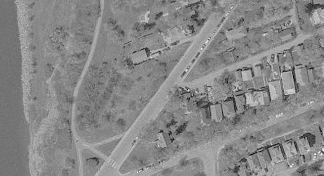
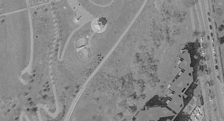
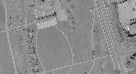
2 Memorandum AECOM ConnectEd Transit Partnership Street, Suite 1200, Edmonton, AB, Canada T5J 3E9 To Brad Griffith Page 1 CC Subject File, Jeff Ward, Gordon Menzies, ynn Maslen, Josh Jones, Russ Coulombe Valley ine RT North Bank Access Route From Mark Perry Date December 19, 2013 Project Number This memo summarizes the options regarding the short term construction and long term maintenance and emergency access to the Valley ine tunnel portal and Tawatinâ Bridge on the north bank of the North Saskatchewan River. Short term construction access could include bringing in material and equipment required to build the tunnel, portal, bridge and any landscaping or pathway reconstruction. There is also the potential the access could be used for removal of excavated material from the tunnel. ong term access would be for regular maintenance of the tunnel and Tawatinâ Bridge and any emergency services required in the tunnel or on the bridge. The current design shows both the short term and long term access from Cameron Avenue. A potential minor secondary access was identified through ouise McKinney Park in the Environmental Impact Screening Assessment (EISA) in this way: Construction access for the portal structure is designated as from the east, via Cameron Avenue but, as planning proceeds, the need for a secondary access from the west, through ouise McKinney Park, may also be identified. For this reason, this environmental assessment assumes an as yet unidentified secondary access from the west but also assumes that this access will be limited and will not require physical modification. Therefore, secondary access is not shown on figures, is considered to be outside of the study area and is only assessed qualitatively. For an access through ouise McKinney Park to be used for construction would require some upgrading and therefore further review and approval to be compliant with Bylaw 7188 (North Saskatchewan River Valley Area Redevelopment Plan) Access from Cameron Avenue, although feasible, has some inherent issues. The primary issue is that the main contractor access, which would include large heavy loads and equipment, would travel down a fairly steep road through a residential neighbourhood. CTP was asked to evaluate other potential access options including through ouise McKinney Park to mitigate some of these concerns. MEMO V-North Bank Access Review.Docx
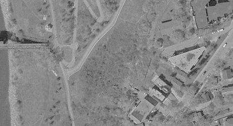
3 Page 2 Valley ine North Bank Covering December Potential Access Alignments In addition to the Cameron Avenue access 3 alternate alignments were identified for access from the west. The alignments are shown on Figure 1. West Access Alignment 1 is from Grierson Hill past the Riverfront Plaza along the existing SUP to the bridge site on the north bank. Access to the tunnel portal site would follow the same route as the new portion of the Cameron Access route. West Access Alignment 2 is from Grierson Hill along the existing maintenance road through ouise McKinney Park. At the east end of the existing maintenance road the access route would cross through the World Walk and over a Shared Use Path (SUP) on sufficient fill to meet the elevation of the tunnel portal. Access to the bridge site on the north bank would need to go through the portal site or use the Cameron Avenue access. Figure 2 shows the profile of the Alignment 2. West Access Alignment 3 is from a SUP connection on Grierson Hill modified to accommodate construction vehicles. The route would follow the existing SUP to a point where a new connection would be provided to the tunnel portal site. To access the bridge site vehicles could either continue along the SUP or cross the tunnel portal site and access along the Cameron Avenue access connection. Figure 3 shows the profile of the Alignment 3. All of the alternate alignments would require upgrading of the SUPs or maintenance roads to accommodate construction loads. In some cases this will be building up the road structure and widening the existing structure. Alternative Comparison The attached summary identifies some of the items of consideration for the alternate alignments. It should be noted that the existing access shown in the Preliminary Design has been approved via the EISA and any substantial work that is in additional to what is discussed in the EISA may trigger a new EISA. RT D&C has agreed that the long term access can be maintained via Cameron Avenue as this would be used only sporadically for regular maintenance and emergencies. The biggest concern and impact on the adjacent residents would be the short term access during the construction phase. The Cameron Avenue alignment provides the best long term routing for maintenance and emergency access since the anticipated frequency is relatively low, therefore not expecting to impact residents significantly, and sharing less SUPs than the west alignments. The short term construction access will have significant impact on the adjacent residents. West Access Alignment 1 does not improve on the Cameron Avenue Alignment for maintenance and emergency access since the vehicles would need to be routed along more than 600 metres of SUP before getting to the same new access road that would be needed MEMO V-North Bank Access Review.Docx
4 Page 3 Valley ine North Bank Covering December for the Cameron route. The main advantage to Alignment 1 is that the route skirts the former dump site and since it runs along the base of the slope, appears to be the most geotechnically stable. This route also does not require any more significant retaining walls or structures than identified in the Cameron Avenue route. Alignment 1 does have a significant impact on the use of the Riverside Plaza and Promenade. A major event planned for the winters of 2015, 2017, and 2019 would require closure of this route for approximately 6 weeks. There is the potential to access the site using Alternative 1 and exit through Cameron Avenue during construction. West Access Alignment 2 would require significant grading over the existing World Walk in ouise McKinney Park to have vehicles access the tunnel portal site. This additional loading on the sensitive side slope and crossing the former dump site make this route less desirable geotechnically and therefore not recommended for short or long term access. As with Alignment 1 this route will be closed for approximately 6 weeks for the major event planned for the winters of 2015, 2017, and West Access Alignment 3 does not provide good maintenance and emergency access for the long term since the connection to Grierson Hill will be restricted to a right turn onto the access road and therefore become a one way road only. For construction access Alignment 3 would require building up the connection of the SUP to Grierson Hill. This could be incorporated into the proposed park viewpoint at this location. However there is concern that this connection would add load to the top of a historic slide area. As well additional work and retaining walls would be required to connect the SUP to the tunnel portal site. Upgrading the SUP to reach the bridge site would be likely, even for a construction access only, since the existing slope does not allow for an access road to be built adjacent to the existing path. Similar to Alignment 1 this alignment would need to be used as a one way in access for construction traffic with Cameron Avenue as the exit from site. Recommendation Due to the relatively low frequency of maintenance vehicles and the expectation that the maintenance vehicles will not be large vehicles the permanent maintenance and emergency access should come off of Cameron Avenue. This will minimize the amount of trails and park space that will have the maintenance vehicles cross through for the long term. For the short term construction access, impact on the residents needs to be weighed against the impact on ouise McKinney Park. To balance the impact consideration can be given to using West Access Alignment 1 as the access to the site and Cameron Avenue as the exit from site. This would mean that the heavier loads of construction materials such as concrete and bridge equipment would access along the SUP that would need structural upgrading instead of along Cameron Avenue. This route will need to be reviewed with Parks and event organizers to determine if it is feasible considering businesses and events planned along this route. Costs should be comparable to using the Cameron Avenue alignment as a 2 way route since there should be no significant additional retaining walls required for the construction access and the use of Cameron as a one way route only would reduce the rehabilitation costs of Cameron Avenue. As with all the alignments, additional geotechnical investigation will be required to confirm the need for structural stability, the ability to build a construction access adjacent to the SUP, or, where needed, the upgrading of the SUP to support construction loads. MEMO V-North Bank Access Review.Docx

5 Page 4 Valley ine North Bank Covering December If West Access Alignment 1 is determined to be unfeasible due to park and event restrictions than West Access Alignment 3 should be considered as a one way access to the site with the exit to Cameron Avenue. There is a higher geotechnical risk with this option due to placing the route along the top of the slope. The slope stabilizing and additional required retaining walls to access the portal site increase the costs of the option substantially. MEMO V-North Bank Access Review.Docx

6 OD TOP OF BANK CA ME R FI AND RETAINING WAS EXISTING TOP OF BANK AT 3 ON AV E UPGRADE SUP AS REQUIRED WORD WAK OD RIVER EDGE NEW PATH WITH RETAINING WAS AT 2 SHAW CONFERENCE CENTRE CAMERON AVE AIGNMENT FI REQUIRED MAINTENANCE ROAD TO BE UPGRADED UPGRADE SUP AS REQUIRED RIVERFRONT PAZA AT 1 RIVERFRONT PROMENADE THE CITY OF TRANSPORTATION SERVICES UPGRADE SUP AS REQUIRED
7
8
9 Summary of Valley ine RT West River Bank Access Alignments Criteria Cameron Avenue Alignment West Alignment 1 West Alignment 2 West Alignment 3 Geometric Steepest Grades approx. 12% Steepest grades approx. 15% Steepest grades approx. 15% Steepest grades approx. 15% Considerations Connecting Road Cameron Avenue is a local collector road providing access to/from Riverdale community. Grierson Hill is a arterial road designated as 24 hour truck route Grierson Hill is a arterial road designated as 24 hour truck route Grierson Hill is a arterial road designated as 24 hour truck route Residential Impacts Access Considerations Route Upgrade and Restoration Tunnel Portal Construction Access Bridge Site Construction Access -Cameron Avenue on street parking would be banned -Private Property access would be impacted -Construction traffic adjacent to curb walks -Noise, vibration, dust, saftey concerns for adjacent residents Parking ban would be required on Cameron Avenue with a tight corner to make at bottom of Cameron Ave. Pavement damage leading to repaving/reconstruction of Cameron Avenue following construction. Approximately 170 m of SUP would then need postconstruction restoration. Some tree removal may be required. Via new access road None if used as 2 way access. Similar, yet less, impacts if to Cameron Avenue Alignment if Cameron Ave is used as as an exit. Traffic Signal may be needed on Grierson Hill Potentially 370 m of SUP along north river bank would require upgrading to accommodate construction vehicles and would then need post-construction restoration. Potential accomodation of a contruction access along the SUP would require potential grading, road preparation, and restoration. Some tree removal may be required. Via same new access road as Cameron Avenue alignment (This option does not provide permanent access to Tunnel) None if used as 2 way access. Similar, yet less, impacts if to Cameron Avenue Alignment if Cameron Ave is used as as an exit. Traffic Signal may be needed on Grierson Hill Approximately 310 m of maintenance access road would require upgrading and would then need post-construction restoration. Use as permanent access would mean that World Walk and rose garden would need to be relocated. Via new access connection through World Walk site (This option does not provide permanent access to Tunnel) Via existing SUP Along existing SUP Via additional access road through World Walk area or along West Alignment 1 Retaining Walls Required for new access road Required for new access road Potentially needed through park site to accommodate final access road configuration None if used as 2 way access. Similar, yet less, impacts if to Cameron Avenue Alignment if Cameron Ave is used as as an exit. Geometry may only allow right turns off of Grierson Hill. May require additional route to exit site. SUP would require upgrading for construction access and would then then need post-construction restoration. Constructing adjacent to SUP is unlikely due to steep side slopes. Some temporary retaining structures may be required. Some tree removal may be required. Via new connection from SUP Via existing SUP or new access road similar to Cameron Avenue alignment Required at access to Grierson Hill and along access to portal site Known restrictions on route use Snow Clearing EISA ouise McKinney Park: Impact to Trail Users Impact to Programmed and Unprogrammed Park Uses None Coordination with Road Maintenance for Cameron Ave clearing Included in EISA. No further approval required. Approxmately 170 m of SUP, the only existing trail access from the east, would be closed to users during construction Does not affect programmed use; adjacent lands do not support unprogrammed use, therefore no impact. Would not be able to use route for 6 weeks during winter of 2015, 2017, & 2019 due to major park event. Contractor Responsibility for snow clearing route through park Indentified as potential secondary access in EISA. Would require additional submission and approval. Potentially additional 370m of SUP would be closed to use during construction Interrupts access to Riverside Promenade which supports programmed and unprogrammed use; impacts two businesses at the Riverfront Plaza. Indirect impact on quality of unprogammed use of adjacent lands. Would not be able to use for 6 weeks during winter of 2015, 2017, & 2019 due to major park event. Contractor Responsibility for snow clearing route through park Indentified as potential secondary access in EISA. Would require additional submission and approval. Approximately 310 m of maintenance access road would be unavailable to park management but this route is not a designated pathway so there would be no impact to formal trail system. Does not directly impact programmed use but indirectly impacts quality of unprogrammed use of adjacent lands. Would be closed for 4 days for major park event during winter of 2015, 2017, & Contractor Responsibility for snow clearing route through park Indentified as potential secondary access in EISA. Would require additional submission and approval. Additional 450m of SUP would be closed to users during construction. No impact on programmed use but indirectly affects quality of unprgrammed use on adjacent lands. Page 1 of 2
10 Summary of Valley ine RT West River Bank Access Alignments Criteria Cameron Avenue Alignment West Alignment 1 West Alignment 2 West Alignment 3 Geotechnical: Decommissioned andfill (limits approximated) Within the landfill but very near the NE limits. Eastern half is within the landfill. Test holes indicated the presence of uncontrolled fill soils mixed with waste materials. Depths are not confirmed in this location. The existing fill/waste subgrade could be unsuitable to support construction traffic. Majority of this route is through the centre of the landfill. Test holes indicated the presence of uncontrolled fill soils mixed with waste materials up to 25 m thick. The existing fill/waste subgrade could be unsuitable to support construction traffic. Eastern two-thirds descends into the landfill. Test holes indicated the presence of uncontrolled fill soils mixed with waste materials. Depths are not confirmed in this location. The existing fill/waste subgrade could be unsuitable to support construction traffic. Construction Route Structure The existing SUP structure is unknown, but unlikely to have been designed to support heavy construction traffic. SUP structure assessment/upgrading will be required. The existing SUP structure is unknown, but unlikely to have been designed to support heavy construction traffic. SUP structure assessment/upgrading will be required. Access Road adjacent to the SUP would also need confirmation of suitable structure. The condition of the existing maintenance access road structure is unknown, but unlikely to have been designed to support heavy construction traffic. Road structure assessment/upgrading will be required. The existing SUP structure is unknown, but unlikely to have been designed to support heavy construction traffic. SUP structure assessment/upgrading will be required. Slope Stability/Grierson Hill Slide This option will have the least impact on the stability of the Grierson Hill slide Fill embankment woud be required across the World Walk and SUP to get from maintenance road to tunnel portal site. Embankment fills will exert additional loading on the Grierson Hill and, depending on their height, can trigger slope movement. Will require geotechnical evaluations to determine the impact of the proposed fills on the stability of the valley slope. This route (particularly the northern section) is close to the scarp/crest of the Grierson Hill slide. Fills, and to a lesser extent cuts, near the scarp of the slide could be detrimental to the stability of the slope (the worst location to add fills is at/near the crest of the slide). This option will require geotechnical evaluations to determine the impact of the proposed earth works on the stability of the valley slope. Fill and retaining wall required to access portal and therfore would be placing loading on the slope. Page 2 of 2
A. CONCLUSIONS OF THE FGEIS
 Chapter 11: Traffic and Parking A. CONCLUSIONS OF THE FGEIS The FGEIS found that the Approved Plan will generate a substantial volume of vehicular and pedestrian activity, including an estimated 1,300
With the first portion of this process complete, we anticipate the general timeline for the remainder of the process to be:
 THE CITY OF FIRE RESCUE E D M O N T O N FIRE RESCUE SERVICES 10351 96 Street Edmonton, Alberta T5H 2H5 April 19, 2013 Dear Rossdale residents: As many of you know, Fire Rescue Services is currently in
12, 14 and 16 York Street - Amendments to Section 16 Agreement and Road Closure Authorization
 REPORT FOR ACTION 12, 14 and 16 York Street - Amendments to Section 16 Agreement and Road Closure Authorization Date: April 27, 2018 To: Toronto and East York Community Council From: Senior Strategic Director,
Gold Coast. Rapid Transit. Chapter content. Chapter four Route selection and staging
 Chapter four Route selection and staging Gold Coast Rapid Transit Chapter four Route selection and staging Chapter content Route selection...73 Section one: Helensvale to Griffith University...74 Section
Section 106 Update Memo #1 Attachment D. Traffic Diversion & APE Expansion Methodology & Maps
 Section 106 Update Memo #1 Attachment D Traffic Diversion & APE Expansion Methodology & Maps I-65/I-70 North Split Interchange Reconstruction Project (Des. Nos. 1592385 & 1600808) Traffic Diversion and
Lake Erie Commerce Center Traffic Analysis
 LOCATION: East of NYS Route 5 at Bayview Road Town of Hamburg Erie County, New York PREPARED BY: Wendel Companies 140 John James Audubon Parkway Suite 200 Amherst, New York 14228 January 2012 i ii Table
Section 3.6 Recreation
 3.6 RECREATION This section evaluates the potential impacts of the proposed project on recreation within MTRP. The evaluation is based on field observations, a review of maps of MTRP and the MTRP Master
TORONTO TRANSIT COMMISSION REPORT NO.
 Revised: March/13 TORONTO TRANSIT COMMISSION REPORT NO. MEETING DATE: November 18, 2013 SUBJECT: YONGE-EGLINTON AND EGLINTON WEST INTERCHANGE STATIONS METROLINX EGLINTON CROSSTOWN LIGHT RAIL TRANSIT PROJECT
1 PROJECT STATUS UPDATE 2 ND CONCESSION FROM BRISTOL ROAD TO DOANE ROAD TOWNS OF EAST GWILLIMBURY AND NEWMARKET
 Report No. 3 of the Regional Council Meeting of March 28, 2013 1 PROJECT STATUS UPDATE 2 ND CONCESSION FROM BRISTOL ROAD TO DOANE ROAD TOWNS OF EAST GWILLIMBURY AND NEWMARKET The recommends: 1. Receipt
PURPOSE AND NEED (CONCURRENCE POINT 1) NEW CANADA ROAD PROJECT FROM STATE ROUTE 1 (U.S. HIGHWAY 70) TO U.S. INTERSTATE 40
 NEW CANADA ROAD PROJECT FROM STATE ROUTE 1 (U.S. HIGHWAY 70) TO U.S. INTERSTATE 40") PURPOSE AND NEED (CONCURRENCE POINT 1) NEW CANADA ROAD PROJECT FROM STATE ROUTE 1 (U.S. HIGHWAY 70) TO U.S. INTERSTATE 40 Project Description The primary purpose of this project is to improve the major
PURPOSE AND NEED (CONCURRENCE POINT 1) NEW CANADA ROAD PROJECT FROM STATE ROUTE 1 (U.S. HIGHWAY 70) TO U.S. INTERSTATE 40 Project Description The primary purpose of this project is to improve the major
Madison Metro Transit System
 Madison Metro Transit System 1101 East Washington Avenue Madison, Wisconsin, 53703 Administrative Office: 608 266 4904 Fax: 608 267 8778 TO: FROM: SUBJECT: Plan Commission Timothy Sobota, Transit Planner,
3. COLTA / HUGA CONNECTIONS - PRELIMINARY
 9 3. COLTA / HUGA CONNECTIONS - PRELIMINARY 3.1 COLTA The Chain of Lakes Trail Association (COLTA) trail, formerly identified as the Chester Spur Line, was completed and opened for use in June 2011. The
Glasgow Street Traffic Review
 Glasgow Street Traffic Review Recommendation That the Standing Policy Committee on Transportation recommend to City Council: 1. That the Administration proceed with removing the pinch points installed
RIVER ACCESS STRATEGY
 RIVER ACCESS STRATEGY The River Access Strategy is a 10-year plan the City of Edmonton is developing to inform future programming, operations and infrastructure improvements that support access to the
London Borough of Barnet Traffic & Development Design Team
 London Borough of Barnet Traffic & Development Design Team AERODROME ROAD PEDESTRIAN FACILITY AND BUS STOP INTRODUCTION FEASIBILITY REPORT Job Number: 60668 Doc Ref: S106/12-13/60668 Author: Manoj Kalair
MEMORANDUM. Lynn Hayes LSA Associates, Inc.
 MEMORANDUM To: Lynn Hayes LSA Associates, Inc. Date: May 5, 217 From: Zawwar Saiyed, P.E., Senior Transportation Engineer Justin Tucker, Transportation Engineer I Linscott, Law & Greenspan, Engineers LLG
Construction Staging Adelaide Street West
 REPORT FOR ACTION Construction Staging Adelaide Street West Date: October 6, 2016 To: Toronto and East York Community Council From: Acting Director, Transportation Services, Toronto and East York District
Longmont to Boulder Regional Trail Jay Road Connection DRAFT FINAL REPORT
 Longmont to Boulder Regional Trail Jay Road Connection DRAFT FINAL REPORT December 2018 Project Summary Boulder County, Colorado, in partnership with the City of Boulder, is evaluating options for multi-use
Construction Access Routes
 Sociedad Minera Cerro Verde S.A.A. Primary Sulfide Project Feasibility Study Project No. 12 7606 00 Construction Access Routes Document No. C-EV-10-003 Rev. B 1 March 2004 Prepared by: Fluor Engineering
Add-A-Lane Contract V. along a Section of I-95 includes 6 Bridges
 Newton Needham Chamber of Commerce Add-A-Lane Contract V along a Section of I-95 includes 6 Bridges Project File No. 603711 July 29, 2014 1 Agenda Project Update Overview Bid and Contract Award Schedule
CHAPTER 3 ALTERNATIVES CONSIDERED
 CHAPTER 3 ALTERNATIVES CONSIDERED 3.0 ALTERNATIVES The 2010 Stevensville Airport Master Plan contained five (5) airside development options designed to meet projected demands. Each of the options from
Construction Staging Area Blue Jays Way (357 King Street West)
") REPORT FOR ACTION Construction Staging Area Blue Jays Way (357 King Street West) Date: June 8, 2018. To: Toronto and East York Community Council From: Acting Director, Transportation Services, Toronto
REPORT FOR ACTION Construction Staging Area Blue Jays Way (357 King Street West) Date: June 8, 2018. To: Toronto and East York Community Council From: Acting Director, Transportation Services, Toronto
Welcome. Green Line in Your Community
 Welcome Green Line in Your Community Today s session will provide you with information on options The City is exploring for connecting the Green Line in the Beltline to the future Inglewood/Ramsay station.
Agenda Report. Spruce Street Outlet Drainage Improvements Tower Road Relief Sewer
 Agenda Report Subject: Prepared By: Spruce Street Outlet Drainage Improvements Tower Road Relief Sewer Steven M. Saunders, Director of Public Works/Village Engineer Date: August 12, 2012 On March 8, 2012
Blackburn Road Blackburn Level Crossing Removal. Frequently Asked Questions August 2014 GENERAL
 Frequently Asked Questions August 2014 Blackburn Road Blackburn Level Crossing Removal GENERAL What is the project? The Victorian Government has committed to eliminating a number of the busiest level crossings
2. STAKEHOLDER FEEDBACK // What We Heard
 1. QUARRY ROAD TRAIL // Welcome to the Information Session PROJECT DESCRIPTION WHY WE ARE HERE Quarry Road Trail is a popular commuter trail and recreational area for Calgarians. 1. To report citizen feedback
As the Toronto Transit Commission (TTC) operates a transit service on Bay Street, City Council approval of this report is required.
 operates a transit service on Bay Street, City Council approval of this report is required.") REPORT FOR ACTION Construction Staging Area - 81 Bay Street Date: December 11, 2017 To: Toronto and East York, Community Council From: Acting Director, Transportation Services Toronto and East York District
REPORT FOR ACTION Construction Staging Area - 81 Bay Street Date: December 11, 2017 To: Toronto and East York, Community Council From: Acting Director, Transportation Services Toronto and East York District
THRESHOLD GUIDELINES FOR AVALANCHE SAFETY MEASURES
 BRITISH COLUMBIA MINISTRY OF TRANSPORTATION & INFRASTRUCTURE AVALANCHE & WEATHER PROGRAMS THRESHOLD GUIDELINES FOR AVALANCHE SAFETY MEASURES British Columbia Ministry of Transportation & Infrastructure
MP : the top of the bottom switchback
 MP 237 238: the top of the bottom switchback For reference this section of U S Highway 40 has been called the top of the bottom switchback on the Grand County side of the Pass. It is here that the proposed
Gold Coast. Rapid Transit. Chapter twelve Social impact. Chapter content
 Gold Coast Rapid Transit Chapter twelve Social impact Chapter content Social impact assessment process...235 Existing community profile...237 Consultation...238 Social impacts and mitigation strategies...239
Stage 2 ION: Light Rail Transit (LRT) from Kitchener to Cambridge
 from Kitchener to Cambridge") Stage 2 ION: Light Rail Transit (LRT) from Kitchener to Cambridge Public Consultation Centre (PCC) No. 3 Please Sign-in Cambridge City Hall November 21, 2017 2:00 to 8:00pm Preston Memorial Auditorium
Stage 2 ION: Light Rail Transit (LRT) from Kitchener to Cambridge Public Consultation Centre (PCC) No. 3 Please Sign-in Cambridge City Hall November 21, 2017 2:00 to 8:00pm Preston Memorial Auditorium
Addendum - Airport Development Alternatives (Chapter 6)
") Bowers Field Addendum - Airport Development Alternatives (Chapter 6) This addendum to the Airport Development Alternatives chapter includes the preferred airside development alternative and the preliminary
Bowers Field Addendum - Airport Development Alternatives (Chapter 6) This addendum to the Airport Development Alternatives chapter includes the preferred airside development alternative and the preliminary
Planning Approval Consistency Assessment Form
 Integrated Management System Planning Approval Consistency Assessment Form SM ES-FT-414 Sydney Metro Integrated Management System (IMS) Applicable to: Document Owner: System Owner: Status: Sydney Metro
Neighbourhood Committee NDG - Westmount. September 12, 2016
 Neighbourhood Committee NDG - Westmount September 12, 2016 2 Presentation Outline Requests from the committee members Feedback on previous questions Work update and hindrance of the Turcot Project Ministry
LESLIE BARNS & CONNECTION TRACK. Construction Liaison Group Meeting #6 January 30, 2014
 LESLIE BARNS & CONNECTION TRACK Construction Liaison Group Meeting #6 January 30, 2014 Construction Liaison Group Jan 30 2014 1 OVERVIEW HAPPY BELATED NEW YEAR Works to Date Underground Utilities Bell
SECTION 55A1 ROBINSON TOWNSHIP IN WASHINGTON COUNTY
 WEEK ENDING FEBRUARY 1, 2019 SECTION 55A1 ROBINSON TOWNSHIP IN WASHINGTON COUNTY Contractor: Independence Excavating Inc. 1. Work Shift Day shift (M-F), with Saturday as a makeup day. 2. Traffic The new
Trails Technical Committee
 Trails Technical Committee Winter 2017 Draft Report Alignment Proposals for the Inyo National Forest and the Town of Mammoth Lakes Map ID #S18 February 08, 2017 Map ID #S18 Key Agreements As of February
BOAT DOCKS AND LAUNCHES. Public Engagement Report July 2015
 BOAT DOCKS AND LAUNCHES Public Engagement Report July 2015 TABLE OF CONTENTS BACKGROUND 3 STAKEHOLDER CONSULTATION 6 PARTICIPANT PROFILE 7 RESPONSE THEMES 8 CONCLUSION 16 BACKGROUND The North Saskatchewan
October 18, Terry Hartwick Director, North Little Rock Parks and Recreation 2700 Willow Street North Little Rock, AR 72114
 October 18, 017 Terry Hartwick Director, North Little Rock Parks and Recreation 700 Willow Street North Little Rock, AR 7114 Dear Mr. Hartwick: Re: ARDOT Job Number CA060 30 Crossing Pulaski County The
Chapter 14 Route Window C12 Mile End Park and Eleanor Street shafts. Transport for London
 Chapter 14 Route Window C12 Mile End Park and Eleanor Street shafts MILE END PARK AND ELEANOR STREET SHAFTS 14 Route Window C12 Mile End Park and Eleanor Street shafts Introduction 14.1 Crossrail s twin
Provincial Railway Technical Standards
 GENERAL: INDEX: The standards and requirements listed in this document are intended for use on provincially regulated railway public grade crossings. These standards are considered the minimum requirements
DEVELOPMENT PERMIT STAFF COMMITTEE REPORT JUNE 19, 2013 CITY OF VANCOUVER PLANNING AND DEVELOPMENT SERVICES
 CITY OF VANCOUVER PLANNING AND DEVELOPMENT SERVICES DEVELOPMENT PERMIT STAFF COMMITTEE REPORT JUNE 19, 2013 FOR THE DEVELOPMENT PERMIT BOARD JULY 15, 2013 760 PACIFIC BOULEVARD (COMPLETE APPLICATION) DE408507/408622
Dufferin Jog Elimination Project
 Project Project Status Update November 14 2007 Project History Planning Alternatives Criteria Measured Project Benefits Structural Configurations Considered Structural Design Considerations The Preferred
Spadina Avenue which would include two new underground stations located at Yonge Street and at University Avenue.
 TORONTO TRANSIT COMMISSION REPORT No S7 MEETING DATE June 4, 1968 FROM: General Manager Subway Construction Date June 3, 1968 Subject: QUEEN STREET SUBWAY FOR STREETCAR OPERATION The Commission, at its
STAFF REPORT TO COUNCIL
 i CITYOF PRINCE GEORGE STAFF REPORT TO COUNCIL 1100 Patricia Blvd. I Prince George, BC, Canada V2L 3V9 I www.pri ncegeorge.ca DATE: January 24, 2017 TO: NAME AND TITLE: SUBJECT: MAYOR AND COUNCIL Dave
Draft Concept Alternatives Analysis for the Inaugural Airport Program September 2005
 Section 10 Preferred Inaugural Airport Concept 10.0 Introduction The Preferred Inaugural Airport Concept for SSA was developed by adding the preferred support/ancillary facilities selected in Section 9
AGENDA ITEM 5 D WAKULLA ENVIRONMENTAL INSTITUTE (WEI) TRAIL FEASIBILITY STUDY
 TRAIL FEASIBILITY STUDY") March 19, 2018 AGENDA ITEM 5 D WAKULLA ENVIRONMENTAL INSTITUTE (WEI) TRAIL FEASIBILITY STUDY TYPE OF ITEM: Action STATEMENT OF ISSUE The Wakulla Environmental Institute (WEI) Trail is one of several trails
March 19, 2018 AGENDA ITEM 5 D WAKULLA ENVIRONMENTAL INSTITUTE (WEI) TRAIL FEASIBILITY STUDY TYPE OF ITEM: Action STATEMENT OF ISSUE The Wakulla Environmental Institute (WEI) Trail is one of several trails
Decision Memo Broken Wheel Ranch Equestrian Outfitter Special-Use Permit Proposed Action
 Decision Memo Broken Wheel Ranch Equestrian Outfitter Special-Use Permit USDA Forest Service Mississippi Bluffs Ranger District, Shawnee National Forest Jackson and Union Counties, Illinois Proposed Action
BACKCOUNTRY TRAIL FLOOD REHABILITATION PROGRAM
 BACKCOUNTRY TRAIL FLOOD REHABILITATION PROGRAM Backcountry Trail Flood Rehabilitation A June 2013 Flood Recovery Program Summary In June 2013, parts of Southern Alberta were devastated from significant
Appendix B Connecting Track Options Evaluation Criteria
 Appendix B Connecting Track Options Evaluation Criteria 608979-853_ra_July5-0_App Title Pages.Docx TTC ASHBRIDGES BAY MAINTENANCE AND STORAGE FACILITY CONNECTING TRACK ROUTE ALTERNATIVE - EVAULATION MATRIX.0
Appendix 4.8 A. Agency Correspondence and Final APE Statement
 Appendix 4.8 A Agency Correspondence and Final APE Statement Area of Potential Effect for Cultural Resources Introduction The South Coast Rail project requires review by the Army Corps of Engineers (Corps),
SUMMER VILLAGE OF SILVER SANDS. Municipal Development Plan
 SUMMER VILLAGE OF SILVER SANDS Municipal Development Plan Bylaw 253-2014 Adopted August 22, 2014 Summer Village of Silver Sands Municipal Development Plan Bylaw No. 253-2014 Page 2 1 INTRODUCTION 1.1 SETTING
Capital & Counties. October 2007
 Capital & Counties October 2007 Contents!" # $ % % $ & ' "&( # Appendix 1 Appendix 2 1 Introduction 1.1.1 Wincheap regeneration scheme proposes a 600 space Park and Ride facility to replace the existing
Restoration of Historic Streetcar Services in Downtown Los Angeles
 Restoration of Historic Streetcar Services in Downtown Los Angeles Alternatives Analysis Community Update Meeting November 3, 2011 Introduction Local lead agency: Metro Federal lead agency: Federal Transit
November 11, 2009 BY . Planning and Growth Management Department 110 Laurier Avenue West, 4 th Floor Ottawa, Ontario K1P 1J1. Dear Mr.
 November 11, 2009 Planning and Growth Management Department 110 Laurier Avenue West, 4 th Floor Ottawa, Ontario K1P 1J1 BY E-MAIL Attention: Mr. Don Herweyer Dear Mr. Herweyer: Reference: Abbott-Fernbank
Pattullo Bridge Replacement Project
 Pattullo Bridge Overview This document will: Explain the challenges facing the Pattullo Bridge today Share how we propose moving forward translink.ca PAGE 1 History By Order of the Lieutenant Governor
Section 4(f) and Section 6(f) Technical Analysis
 and Section 6(f) Technical Analysis") WESTSIDE SUBWAY EXTENSION PROJECT Contract No. PS-4350-2000 Section 4(f) and Section 6(f) Technical Analysis Prepared for: Prepared by: WSP USA 851 SW Sixth Avenue, Suite 1600 Portland, Oregon 97204 FEBRUARY
WESTSIDE SUBWAY EXTENSION PROJECT Contract No. PS-4350-2000 Section 4(f) and Section 6(f) Technical Analysis Prepared for: Prepared by: WSP USA 851 SW Sixth Avenue, Suite 1600 Portland, Oregon 97204 FEBRUARY
San Martin Boulevard over Riviera Bay Project Development & Environment (PD&E) Study Update PID A
 Study Update PID A") San Martin Boulevard over Riviera Bay Development & Environment (PD&E) Study Update PID 001036A June 12, 2018 Location & Limits Unincorporated Pinellas County City of St. Petersburg 2 Overview Of Alternatives
San Martin Boulevard over Riviera Bay Development & Environment (PD&E) Study Update PID 001036A June 12, 2018 Location & Limits Unincorporated Pinellas County City of St. Petersburg 2 Overview Of Alternatives
City Council Report. Mayor and City Council Susan Cline, Director, Public Works, Civil Engineering Subject: Airport Runway Shortening Options
 City Council Report To: From: Mayor and City Council Susan Cline, Director, Public Works, Civil Engineering Subject: Airport Runway Shortening Options City Council Meeting: May 24, 2017 Agenda Item: 8.A
APPENDIX F List of Commitments
 APPENDIX F List of Commitments s Table F.1 Standard Mitigation Measures Mitigation Measure MnDOT Specification Number Status Update Description Status Update Utilities Provide early notice to utility operators
Engagement Summary Report. Trans-Canada Highway 1 RW Bruhn Bridge Replacement Project. Community Engagement November 15, 2016 to January 15, 2017
 Trans-Canada Highway 1 RW Bruhn Bridge Replacement Project Community Engagement November 15, 2016 to January 15, 2017 Engagement Summary Report February 2017 Prepared by Kirk & Co. Consulting Ltd. Trans-Canada
Meeting Notes Public Open House
 Meeting Notes Public Open House, 5:30-8:00 pm Fairbanks Pipeline Training Center, 3605 Cartwright Court, Fairbanks, Alaska= Agenda: Open House: 30 minutes Presentation: 45 minutes Question and Answers:
A number of goals were identified during the initial work on this Big Lake Transportation Plan.
 C. Transportation General Background Information Big Lake s transportation system includes all the roads, paths and facilities that allow the movement of private vehicles, trains and planes, as well as
East Link Project Update. Maintenance of Traffic During Construction. April 21, 2015
 East Link Project Update Maintenance of Traffic During Construction April 21, 2015 1 Agenda TFP project 242 Bellevue Way HOV Bellevue Way - Maintenance of Traffic During Construction Early Work Utilities
November 21, 2012 Barbara Kelleher, (954)
") November 21, 2012 Barbara Kelleher, (954) 777-4090 barbara.kelleher@dot.state.fl.us BROWARD COUNTY TRAFFIC IMPACT REPORT November 26 to November 30, 2012 FORT LAUDERDALE -- Construction and maintenance-related
November 21, 2012 Barbara Kelleher, (954) 777-4090 barbara.kelleher@dot.state.fl.us BROWARD COUNTY TRAFFIC IMPACT REPORT November 26 to November 30, 2012 FORT LAUDERDALE -- Construction and maintenance-related
Basic Project Information
 FY 2015-16 PROJECT DESCRIPTION FORM (2C) Submitting Agency: Loudoun County Basic Project Information Project Title: Loudoun County Parkway (VA Route 607) U.S. 50 to Creighton Rd. (2C) Project Type (check
Lawrence Loop SWOT Analysis
 Alignment: D1 (Map Color: Dark Blue) Description: This alignment connects to the north end of the Burroughs Creek Trail and continues along the west side of the Railroad to 8 th Street. Strengths: - This
Chair and Members of Harbour East - Marine Drive Community Council. Brad Anguish, Director, Parks and Recreation
 P.O. Box 1749 Halifax, Nova Scotia B3J 3A5 Canada Item No. 15.1.1 Harbour East-Marine Drive Community Council December 3, 2015 TO: SUBMITTED BY: Chair and Members of Harbour East - Marine Drive Community
CREATING CONNECTIONS IN THE CITY OF NIAGARA FALLS PUBLIC MEETING DECEMBER 6, 2017
 CREATING CONNECTIONS IN THE CITY OF NIAGARA FALLS PUBLIC MEETING DECEMBER 6, 2017 CONGESTION COSTS OUR ECONOMY The average commute in Ontario is already over 45 minutes, and that figure jumps to more than
Neighbourdhood Committee NDG-Westmount. October 16, 2017
 Neighbourdhood Committee NDG-Westmount October 16, 2017 2 Presentation Outline Requests from Committee members Feedback on questions Green strip consultations Work update and obstacles Work progress Phase
VI. ALTERNATIVES TO THE MASTER PLAN C. RENOVATED EAST BUILDING ALTERNATIVE
 VI. ALTERNATIVES TO THE MASTER PLAN C. RENOVATED EAST BUILDING ALTERNATIVE INTRODUCTION The Renovated East Building Alternative would include the continued use of the renovated West Building and the renovation
EAST DON TRAIL ENVIRONMENTAL ASSESSMENT. Community Liaison Committee Meeting #3 July 15, :30 to 8:30 pm Flemingdon Park Library
 EAST DON TRAIL ENVIRONMENTAL ASSESSMENT Community Liaison Committee Meeting #3 July 15, 2013 6:30 to 8:30 pm Flemingdon Park Library Agenda 1. Welcome 2. Housekeeping and Updates a) Housekeeping b) CLC
Permeable RECREATIONAL TRAILS
 SMART EARTH SOLUTIONS Permeable RECREATIONAL TRAILS GEOWEB GEOPAVE GEOTERRA Innovative Solutions for Designing & Building Trails. Trail Surface Stabilization The key to planning and building trails into
ROAD AND TRAIL PROJECT APPROVAL
 ROAD AND TRAIL PROJECT APPROVAL www.marincountyparks.org Marin County Parks, 3501 Civic Center Dr, Suite 260, San Rafael, CA 94903 DATE: July 12, 2017 PRESERVE: Gary Giacomini Open Space Preserve PROJECT:
Hospital Link Project Project Update Winter 2018
 Hospital Link Project Project Update Winter 2018 General The project provides a link from Riverside Drive and the Transitway to the Hospital Link Road. Construction of the Hospital Link facility is open
Woodbine Station Easier Access Project Public Open House January 27, :30 pm 8:30 pm Consultation Summary Report
 Woodbine Station Easier Access Project Public Open House January 27, 2014 6:30 pm 8:30 pm Consultation Summary Report Danforth Mennonite Church 2174 Danforth Ave Prepared by Lito Romano February 18, 2014
Northeast Stoney Trail In Calgary, Alberta
 aci Acoustical Consultants Inc. 5031 210 Street Edmonton, Alberta, Canada T6M 0A8 Phone: (780) 414-6373, Fax: (780) 414-6376 www.aciacoustical.com Environmental Noise Computer Modelling For Northeast Stoney
Long water shutdown scheduled for Tuesday, September 18
 Thank you for your interest in the Center City Connector Streetcar. In this weekly update, you ll find information about ongoing construction for the 1st phase of utility work in Pioneer Square. Utility
APPENDIX H MILESTONE 2 TRAFFIC OPERATIONS ANALYSIS OF THE AT-GRADE CROSSINGS
 Draft Environmental Impact Statement/Environment Impact Report Appendix H Milestone 2 Traffic Operations Analysis of the At-Grade Crossings APPENDIX H MILESTONE 2 TRAFFIC OPERATIONS ANALYSIS OF THE AT-GRADE
Interstate 90 and Mercer Island Mobility Study APRIL Commissioned by. Prepared by
 Interstate 90 and Mercer Island Mobility Study APRIL 2017 Commissioned by Prepared by Interstate 90 and Mercer Island Mobility Study Commissioned by: Sound Transit Prepared by: April 2017 Contents Section
Northern Rail Extension, Phase One
 General Project and Funding 1. Where does Phase One start? The rail line for Phase One begins roughly at the northern boundary of the former Bradbury property, but also includes work along Tom Bear Trail
377 Spadina Rd & 17 Montclair Ave Zoning Amendment Application Final Report
 STAFF REPORT ACTION REQUIRED 377 Spadina Rd & 17 Montclair Ave Zoning Amendment Application Final Report Date: September 14, 2016 To: From: Wards: Reference Number: Toronto and East York Community Council
TORONTO TRANSIT COMMISSION REPORT NO.
 Revised: March/13 TORONTO TRANSIT COMMISSION REPORT NO. MEETING DATE: March 26, 2014 SUBJECT: KENNEDY INTERCHANGE STATION: METROLINX EGLINTON CROSSTOWN LIGHT RAIL TRANSIT PROJECT - PRELIMINARY CONCEPT
9 CONSTRUCTION OF BATHURST STREET FROM GREEN LANE WEST TO SOUTH OF HIGHWAY 11, TOWN OF EAST GWILLIMBURY AND TOWNSHIP OF KING
 Clause No. 9 in Report No. 9 of Committee of the Whole was adopted, without amendment, by the Council of The Regional Municipality of York at its meeting held on May 15, 2014. 9 CONSTRUCTION OF BATHURST
Grade Crossing Regulations
 Grade Crossing Regulations An Overview of Municipal Roles and Responsibilities at Federally Legislated Grade Crossings March 21, 2017 presentation to Alberta Municipal Supervisor Association, Edmonton,
Trail Phasing Plan. Note: Trails in the Clear Creek Canyon area (Segments will be finalized in the future to minimize wildlife impacts
 Note: Trails in the Clear Creek Canyon area (Segments 2 5 and a future JCOS connection) will be finalized in the future to minimize wildlife impacts Trail Phasing Plan P Parking 3 Easy Trail Intermediate
PRIORITIES COMMITTEE MEETING
 PRIORITIES COMMITTEE MEETING Meeting Date: 05/13/14 Agenda Item #: 13.1 Northeast Anthony Henday Drive Update Report Purpose To update the Priorities Committee on the progress of the Northeast Anthony
Section 3-04 Cross Sectional Elements TABLE OF CONTENTS. INTRODUCTION...3 General...3 Exhibit 1-Cross-Sectional Elements...3
 Section 3-04 Cross Sectional Elements TABLE OF CONTENTS INTRODUCTION...3 General...3 Exhibit 1-Cross-Sectional Elements...3 CROSS-SECTIONAL ELEMENTS...3 Traveled Way...3 Shoulder...3 Surfacing Taper...3
SR 934 Project Development And Environment (PD&E) Study
 Study") SR 934 Project Development And Environment (PD&E) Study Project Advisory Group Meeting March 1, 2018 State Road 934/NE/NW 79th Street from west of I-95 (NW 13th CT) to N. Bayshore Drive PD&E STUDY SR 934/NE/NW
SR 934 Project Development And Environment (PD&E) Study Project Advisory Group Meeting March 1, 2018 State Road 934/NE/NW 79th Street from west of I-95 (NW 13th CT) to N. Bayshore Drive PD&E STUDY SR 934/NE/NW
Pedestrian Safety Review Spadina Avenue
 STAFF REPORT ACTION REQUIRED Pedestrian Safety Review Spadina Avenue Date: October 13, 2015 To: Toronto and East York Community Council From: Director, Transportation Services, Toronto and East York District
2017 Work and Launch of the Next Phase. Information meeting, Montréal-Ouest September 14, 2017
 2017 Work and Launch of the Next Phase Information meeting, Montréal-Ouest September 14, 2017 2 Presentation Outline Work progress Launch of the next phase Mitigation measures Dismantling Communications
FEASIBILITY CRITERIA
 This chapter describes the methodology and criteria used to evaluate the feasibility of developing trails throughout the study areas. Land availability, habitat sensitivity, roadway crossings and on-street
Bloor Street West Rezoning Application for a Temporary Use By-law Final Report
 STAFF REPORT ACTION REQUIRED 3741 3751 Bloor Street West Rezoning Application for a Temporary Use By-law Final Report Date: June 12, 2007 To: From: Wards: Reference Number: Etobicoke York Community Council
Implications of Construction Cost Escalation
 Implications of Construction Cost Escalation 2007 ACI-NA Economics and Finance Conference James Gill, CPA Deputy Airport Director Finance, Business & Administration Raleigh-Durham Airport Authority Presentation
RIO VISTA MUNICIPAL AIRPORT
 DRAINAGE TECHNICAL MEMORANDUM RIO VISTA MUNICIPAL AIRPORT RIO VISTA, CALIFORNIA Prepared for: City of Rio Vista 1 Main Street Rio Vista, CA 94571 (707) 374-5337 Prepared by: August 2012 Copyright 2012
Maryland Transit Administration. Master Plan Alignment Trail
 Maryland Transit Administration Master Plan Alignment Trail Master Plan Alignment Byrne Kelly Concept Trail Analysis - North vs. South Trail Access & Crossings Aesthetics Master Plan Alignment Description
Night work update: Hills M2 Motorway and westbound on ramp at Pennant Hills Road
 T 1800 997 057 (free call) E enquiries@northconnex.com.au PO Box 343 Pennant Hills NSW 1715 northconnex.com.au 28 April 2017 Ref: N0075M Night work update: and westbound on ramp at Dear resident, NorthConnex
Non-technical summary
 Introduction NTS1 NTS2 NTS3 Troika Developments Ltd (Troika) has submitted a planning application to Bournemouth Borough Council (BBC) for an extension of time to implement planning permission 7/2004/16450/G,
2015 PURDUE ROAD SCHOOL March 11, 2015
 2015 PURDUE ROAD SCHOOL March 11, 2015 Runway Protection Zone (RPZ) Definition It is a trapezoidal shape formed off the end of a runway and its geometry it a function of the airport s aircraft approach
DUFFERIN ELEMENTARY PLANNING STUDY SCHOOL DISTRICT 68 (NANAIMO-LADYSMITH)
") DUFFERIN ELEMENTARY PLANNING STUDY SCHOOL DISTRICT 68 (NANAIMO-LADYSMITH) April 2006 Report Consultants Matrix Planning Associates Unit 2, 933 Meares Street Victoria, British Columbia Canada V8V 5B8 Telephone:
DUFFERIN ELEMENTARY PLANNING STUDY SCHOOL DISTRICT 68 (NANAIMO-LADYSMITH) April 2006 Report Consultants Matrix Planning Associates Unit 2, 933 Meares Street Victoria, British Columbia Canada V8V 5B8 Telephone: