Capital & Counties. October 2007
|
|
|
- Dennis Jacobs
- 5 years ago
- Views:
Transcription

1 Capital & Counties October 2007
2
3 Contents!" # $ % % $ & ' "&( # Appendix 1 Appendix 2
4 1 Introduction Wincheap regeneration scheme proposes a 600 space Park and Ride facility to replace the existing car park This report is intended to review the design and access issues related to the proposed 600 space Park and Ride car park, and issues related to a potential extension to 900 or 1200 spaces Four alternative locations within the development are considered. The report addresses, at a preliminary level, the issues surrounding their layout, appearance, location, bus services and traffic. It does not review the detailed cost implications of location and size. It must be noted that for economic reasons the car park is likely to be on at least two levels and, for the larger sizes, may need to be multi-storey, with increasing costs per space compared to the existing ground level layout This document reviews the key elements of the Park and Ride, alternative locations and operational issues It also reviews the impacts of an increase in parking numbers. Canterbury, Wincheap Park and Ride 1
5 2 Park and Ride Expansion Issues - Summary ) "* +,-./ * 00$1$* The development will need to provide a 600 space Park and Ride car park, to replace the existing Park and Ride. Canterbury City Council has asked that the potential for this to be increased to 900 or 1200 spaces be assessed The analysis of the effects on traffic flows and parking across Canterbury of an enlarged Wincheap facility is outside the scope of this report. ) A number of issues must be considered with regard to expansion of the car parks on Wincheap. Some assessments can be made as part of the Wincheap Studies and some are outwith the scope of that work. 2."" The base scheme must accommodate flows to the replacement of the existing 600 space car park together with the projected traffic flows to the development. The first consideration is the ability of the Peanut junction with the A2 slip roads to accommodate additional traffic associated with the larger Park and Ride. That issue is dealt with in this report. It has been concluded that, based on the existing travel patterns to the Park and Ride, the provision of a larger Park and Ride site is unlikely to be fundamentally unacceptable in terms of traffic capacity. This, however, is based on the proportional utilisation of the existing car park. If that utilisation is dramatically increased, or the proportion arriving during the peak hour is changed through more aggressive parking regimes within the City Centre, the balance will need to be reconsidered. Within the current studies this cannot be evaluated, although a simple sensitivity test is in hand It may be possible to consider it as a more detailed sensitivity check beyond the existing studies or to carry out a more objective exercise on possible transfers out of the City Centre. +$+$* This report sets out a number of sites which have been considered for the Park and Ride within the Wincheap regeneration area. In each case, the report considers phasing issues and the ability to accommodate an enlarged number of parking spaces. In most of the cases it is possible to accommodate a larger Park and Ride although there may be substantial cost implications. $+$* The assessment of each location in this report reviews briefly the impact on the bus operation. A detailed assessment of any costings is outside the scope of any work which WSP are currently carrying out. It is understood that this was being considered by Canterbury City Council. Consideration would have to be given not only to the day to day operational patterns, but extreme conditions such as the weeks running up to Christmas, when it must be assumed that all car parking spaces would be occupied and there would be heavy and peaky demand on the Park and Ride service. The assessment of any enlarged facility would need to consider the potential catchments of users. Canterbury, Wincheap Park and Ride 2
6 3 Highway Capacity Weekday Traffic counts carried out in July 2007 show the existing Park and Ride operation at Wincheap to generate the following peak hour traffic flows: Table 3.1 : Existing Wincheap Park and Ride Traffic Generation AM Peak Hour Arrivals Departures 0 97 Total PM Peak Hour This is equivalent to a trip rate of 0.20 trips per space in the AM peak hour and 0.16 trips per space in the PM peak hour. These are within the range observed in the May and October 2006 counts reported in Table of Canterbury s Fourth Park and Ride Site Transport Assessment, prepared for Canterbury City Council by WSP in July 2007, and gives confidence that observed trip rates are reliable. Put another way 20% of the Park and Ride car park capacity can expect to be filled during the AM peak hour, and 16% to empty during the PM peak hour Studies of the sites in different areas suggest that up to 50% of spaces fill in the peak hour. That figure could only be approached by major restriction on City Centre parking. Observed flows have been used in the assessment The distribution of the Park and Ride trips has been estimated from a combination of a registration matching survey and junction turning movement counts. The resulting distribution is shown at Appendix A and indicates that the majority of Park and Ride users (56%) reach the site from the A28 South, 18% from the A2 East, 17% from the North and West via Rheims Way, and the remaining 9% from Pin Hill and Castle Way. The proportion of trips originating from North and West (Rheims Way) is around half the proportion of trips estimated from this direction (and therefore capable of transfer to a fourth Park and Ride site at Harbledown) in the Table 3.5 of the Fourth Park and Ride Transport Assessment, referred to above. This requires further consideration but represents a cautious approach Park and Ride trips have been assigned to the proposed Wincheap Regeneration road network assuming all existing trips to and from Rheims Way will reroute to access the Park and Ride via the proposed A2 slip roads. The resulting flows are shown at Appendix B Trip generation estimates for a 1200 space Park and Ride have been produced by factoring up the flows associated with the existing facility by the increase in the number of spaces (a factor of 2). This assumes that peak hour arrival and departure rates are the same as existing. This is reasonable given that a change in trip rate implies a city wide change in Canterbury s travel patterns. Policy factors such as substantial reduction in the public or private parking stock might produce such a change but would equally affect a 600 space Park and Ride as a 1200 space facility The 600 space Park and Ride accounts for 110 vehicle trips through the proposed Peanut junction at the southern end of the site in the AM peak hour and 87 movements in the PM peak. Increasing the Park and Ride to 1200 spaces increases these figures to 220 and 174 trips respectively peak hour traffic forecasts (Appendix C) including development traffic from Wincheap Regeneration, indicate total flows through the Peanut junction of 3409 vehicle movements in the AM peak and 3583 in the PM peak with a 600 space Park and Ride. Canterbury, Wincheap Park and Ride 3
7 3.1.9 Adding a further 600 spaces to create a 1,200 space Park and Ride site increases traffic flows through the junction to 3,518 and 3,670 vehicle movements within the AM and PM peaks respectively. These increases of 3.2% and 2.4% are not normally considered to be significant It is essential for safety that long queues do not develop from the stop line at the top of the proposed Eastbound A2 off-slip to interfere with traffic flow on the main A2 carriageway. In the PM peak, Park and Ride traffic does not form part of the circulating flow controlling the exit from the slip road and will therefore have little effect on junction operation In the AM peak, Park and Ride traffic is an important element of the controlling circulating flow. Increases could potentially have an effect on operation of the junction although there is considerable flexibility at this stage of the development proposals to amend the Peanut junction design to suit It can be concluded that increasing the size of the Park and Ride at Wincheap from 600 spaces to 1200 spaces is unlikely to have an insurmountable impact on operation of the Peanut Junction if the pattern of movements reflects the existing facility. [A sensitivity test has been carried out to evaluate the impact of doubling the arrivals flows to the enlarged facility. This simulates an increased attractiveness of the improved facility] Canterbury, Wincheap Park and Ride 4
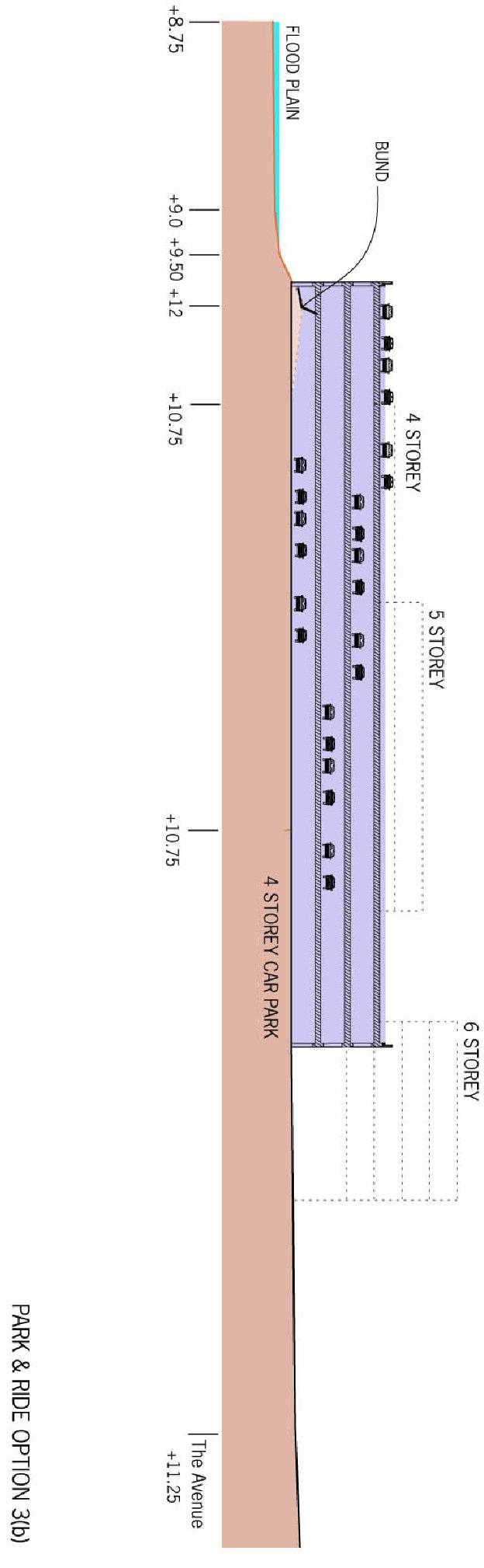
8 4 Site Options #) $ Four alternative car park locations have been identified. Aspects of each site discussed below and are Option 1 Immediately adjacent to the proposed A2/A28 Peanut gyratory Option 2 North west corner of the site, by the A2 NW Corner Option 3 North west of Cow Lane adjacent to the riverside open space Option 4 Cow Lane, backing onto Morrisons supermarket service area Appended to this report are a series of layout plans illustrating, on a preliminary basis, how the car parking might be arranged on the various option sites. A series of preliminary elevational studies by the architect are also appended. It must be recognised that both these elements can only be considered as very preliminary as they have been taken out of context with the normal design process of the scheme. #) $+$*45*-+6 3$"+$* Option 1- Multi-story Car Park located adjacent to the proposed A2 Eastbound exit slip road, Ten Perch Road and the Peanut A2/A28 gyratory junction. The entry and exit roads would be on its North side and form an extension to the boundary. 0"+$**0*" To provide 600 spaces the car park would have 5 floors each split on two levels as shown on Figure PR.06. The east half of each floor would be two aisles wide and set half a floor above the west side The car park would extend four stories above all the adjacent ground and part way along its length it would be about four and a half stories above Ten Perch Road. Lifts would be provided on the North façade which would overlook retail units to their North. ""* 0""- 3+$* Entry and exit would be next to a dual carriageway road forming an extension to The Boundary and with a signalled junction with Ten Perch Road. It would also act as the bus turn round area and incorporate a bus lay-by Cars would enter and leave the car park from its west façade The majority of Park and Ride traffic is likely to come from the A2 slip road and the A28. Option 1 (and Option 2) gives the quickest and most direct access to Park and Ride for these vehicles, and it is likely that the left hand lane of the Peanut gyratory and Ten Perch Road would be used primarily by Park and Ride traffic. The length of the approach road and the lane provision minimises the risk of Park and Ride traffic causing queuing on the slip road There is relatively little opportunity to provide information to drivers on congestion within City Centre car parks, and to encourage them to Park and Ride.,- $+$* The Park and Ride bus route would run from the City along Wincheap (which would be relieved of general through traffic), along Ten Perch Road and to the Park and Ride pick up and set down lay-by. From there buses would do a U-turn onto the Park and Ride exit road and proceed along The Avenue, which would have a bus lane along the majority of its length up to the proposed Wincheap Green gyratory. Canterbury, Wincheap Park and Ride 5
9 4.2.9 At the car park buses would have standing space in the lay-by provided. "$* +-"+$** The whole car park would need to be constructed in a single operation, for which much of the existing Park and Ride car park would need to be taken out of commission. Alternative facilities may be needed. 7* $* $+* There would be little, if any, scope for expansion beyond 600 spaces, which would extend the multi-storey structure above 4 floors high at the entry point to Canterbury from the A2. #) $+$*45* "$*6 3$"+$* This car park would be located in the north west corner of the site, adjacent to the A2 embankment and to the floodplain of the River Great Stour. 0"+$**0*" The car park would be essentially rectangular and on 2 floors. It could accommodate around 650 cars (including disabled provision). The ground floor and single deck could each either be at a single level, with long or helical ramps; or split level with shorter internal ramps As with Option1 there would be little, if any, scope for expansion beyond 600 spaces, which would extend the multi-storey structure above 4 floors high at the entry point to Canterbury from the A2. ""* 0""- 3+$* Access would be from the south east side, using an access from Ten Perch Road.,- $+$* Bus operations would be the same as for Option 1 except that the bus lay-by at the car park would be on the north side of the exit road to be adjacent to the car park The Park and Ride bus route would run from the City along Wincheap (which would be relieved of general through traffic), along Ten Perch Road and to the Park and Ride pick up and set down lay-by. From there buses would do a U-turn onto the Park and Ride exit road and proceed along The Avenue, which would have a bus lane along the majority of its length up to the proposed Wincheap Green gyratory. "$* +-"+$** A full multi-storey structural solution would be required for the 1,200 space option on this site and it is therefore envisaged that the entire car park would need to be constructed in one operation A disadvantage of this site is that it would occupy a portion of the existing Park and Ride site leaving only the southern portion operational while construction proceeds. Park and Ride space may therefore need to be found elsewhere on the development site to compensate as a temporary measure. Canterbury, Wincheap Park and Ride 6
10 7* $* $+* Option 2 can be expanded beyond 600 spaces expansion to 900 or 1200 spaces. This would result in 2 4 additional storeys being required giving a total of 4 6 storeys. It might be possible to construct partial extensions over the entry and exit roads but this would risk an unsightly structure where the facility should be attractive and sit well with the surrounding development. #)# $+$* $"+$* This car park would be located north of Cow Lane, between The Avenue and the river floodplain. 0"+$**0*" The car park would be rectangular and 4 5 aisles deep. It would have split level floors. ""* 0""- 3+$* The floors would likely be split level, with the lower half towards the river and ramps between each half, and the aisles would run parallel to the river Car entry would be from a dedicated car park entry lane from The Avenue into the south west corner. Exit would be from the south east corner to a signalled junction with The Avenue Footways along The Avenue would have a crossing point over the entry lanes and another, possibly signal-controlled, over the exit lane. Park and Ride customers would walk only a few metres from the bus shelter to the car park lifts Locating car parks further into the development has the disadvantage that traffic to the Park and Ride sites will travel extra mileage, and congestion problems may have to be dealt with within the site. There is, however, much greater opportunity to sign drivers to the Park and Ride sites. If signing is not permitted on the trunk road, there will still be opportunity for at least two signs to advise drivers of the state of City Centre car parks and to divert them into the Park and Ride sites. This facility is not available with Options 1 and 2.,- $+$* A separate bus road off The Avenue would include a lay-by in front of the car park for pick up, set down and standing buses. This road would lead directly onto the city-bound (eastbound) bus lane on The Avenue Park and Ride facilities passenger shelter, toilets (if provided), operator s office, drivers'room, lifts would be provided adjacent to the lay-by Park and Ride buses would follow a loop. They would travel city-bound on the bus lane on The Avenue from the car park to the proposed Wincheap Green gyratory. Their return journey would be along Wincheap, which would be relieved of general through traffic, then with general traffic along Ten Perch Road and The Avenue to the car park. "$* +-"+$** The section of The Avenue linking The Boundary and Maynard Road would need to be built before the car park could be built. Canterbury, Wincheap Park and Ride 7
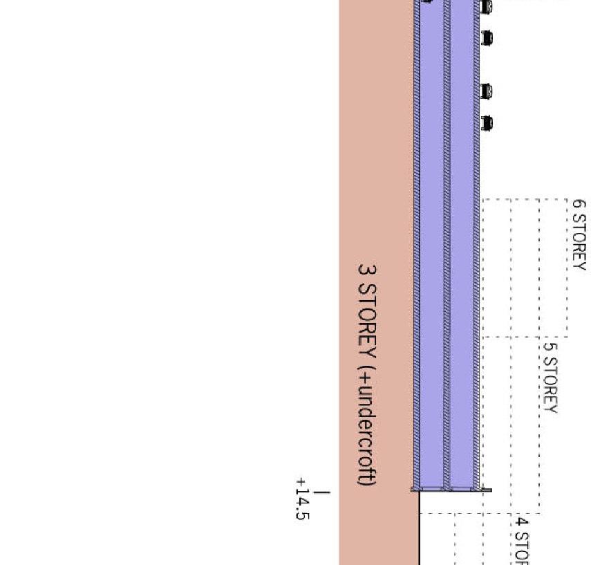
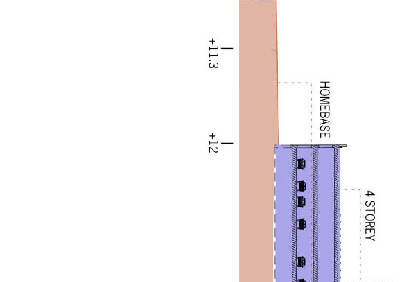
11 7* $* $+* This Option could be expanded upwards the internal circulation requirements would not be well suited to horizontal enlargement The car park would have around 600 spaces on 2 sets of split level floors (ground and first). Each additional set of split level floors would provide an additional 300 spaces. The figures include 6% disabled spaces. The split deck arrangement does not provide the most efficient search patterns. #)% $+$*#45"$ 3*6 3$"+$* This car park would be located on the site of the former railway embankment immediately east of Morrisons supermarket. The embankment would be removed and the car park s west façade constructed parallel to the Morrisons boundary Cow Lane would remain essentially on its present alignment and The Avenue would be positioned to provide adequate forward visibility past the car park The ground levels currently fall by around 4m from the car park s eastern end to The Avenue (currently Cotton Road) to the west. 0"+$**0*" The car park would be multi-storey. For 600 spaces (including disabled user spaces) it would be 2 storeys at the south end and 3 at the north, from which a half length lower ground floor would extend. The layout Option3a assumes that all 600 spaces will be required before Homebase needs to be relocated If this is not a constraint and the car park can be built over its entire footprint from the start, then it would be only 2 storeys high at the north end and be at (embankment) ground level at the south Option 3b The full footprint would comprise a long two-aisle section along the Morrisons boundary, and a parallel shorter two-aisle section in the corner of Cow Lane and The Avenue If the car park were to be enlarged to 1,200 spaces it would be possible to defer construction of the section on the Homebase site, which would allow some degree of expansion The east façade could be hidden by a residential or commercial building, which would form the end of the view along The Avenue. ""* 0""- 3+$* Cars would enter the car park south end from Cow Lane and depart from the north end via a signalised junction onto The Avenue having descended a floor. It is preferable for efficient circulation for cars to enter closest to the buses, so that they park in the first available space Each floor would be on a single level over the entire car park, because of the 4m ground level difference between the north and south ends. Access between floors would be by helical ramps half outside the car park: up at the south and down at the north. An additional up ramp will be required from the lower ground floor if cars are not to use the road network to circulate from it to other floors Locating car parks further into the development has the disadvantage that traffic to the Park and Ride sites will travel extra mileage, and congestion problems may have to be dealt with within the site. There is, however, much greater opportunity to sign Canterbury, Wincheap Park and Ride 8
12 drivers to the Park and Ride sites. If signing is not permitted on the trunk road, there will still be opportunity for at least two signs to advise drivers of the state of City Centre car parks and to divert them into the Park and Ride sites. This facility is not available with Options 1 and 2. A number of issues must be considered with regard to expansion of the car parks on Wincheap to partly, or wholly, replace Harbledown. The assessments can be made as part of the Wincheap Studies and some are outwith the scope of that work.,- $+$* Buses would pick up, set down and stand in a lay-by on the west side of Cow Lane, next to the car park lifts and other facilities Cow Lane would be buses-only northbound. A signal controlled junction would give buses maximum priority onto the city-bound bus lane on The Avenue. The bus lane would have stops along The Avenue and take buses to the front of the queue onto the Ring Road (Rheims Way). Returning from the city to the Cow Lane car park, buses would use Wincheap, which would have local and bus traffic only The Park and Ride bus circuit would be shorter than other locations because the car park location is closer to Canterbury than the existing car park and Options 1 and 2, which are by the A2. "$* +-"+$** Option 4 could be constructed in phases, for Homebase to remain operational concurrently with the car park s first phase being constructed and operational. This first phase layout could achieve around 600 spaces on 3½ floors For this interim layout: The car park would occupy the site of the railway embankment backing onto Morrisons supermarket. Cotton Road would remain kept on its current alignment All cars would use Cow Lane to enter the car park, possibly with traffic signals at its junction with Cotton Road All cars would exit onto Cotton Road The car park could have flat floors and a helical ramp at each end: this is one of the more efficient layouts for filling/emptying. A half length floor at the northern end, provided because the ground slope down about 4m from the southern to northern ends, may need an internal up ramp. The lifts and car entry point are both located at the bus stand (Cow Lane) end to encourage efficient space filling behaviour The car park s smaller north east section would provide around 110 spaces per floor. This could be constructed either with the main section or left until later. The flat (not split level) floor arrangement would facilitate this. 7* $* $+* Expansion from 600 spaces could be done upwards and/or eastwards If the car park is built in its simplest double aisle layout with 600 spaces, 2½ floors and avoiding Homebase, it could be expanded sideways to provide a further 300 spaces. Alternatively it could be expanded upwards by 3 floors to provide about 540 additional spaces. Canterbury, Wincheap Park and Ride 9
13 If it is expanded sideways (east) first, then 2 extra floors would provide 600 more spaces Approximate numbers of spaces for different expansion options are shown in the table below and 6% disabled spaces. Canterbury, Wincheap Park and Ride 10
14 Option 4 Expansion Variants Format North and east façades South façade Basic (rail embankment only) 3 levels 2 levels 620 Basic + expand upwards (a) 4 levels 3 levels 800 Basic + expand upwards (b) 5 levels 4 levels 980 Spaces (approx.) Basic + expand upwards (c) 6 levels 5 levels 1160 Full footprint 2 levels Ground level 580 Full footprint + expand upwards (a) 3 levels 2 levels 770 Full footprint + expand upwards (b) 4 levels 3 levels 1050 Full footprint + expand upwards (c) 5 levels 4 levels 1330 Canterbury, Wincheap Park and Ride 11
15 5 Operational Issues %),-$ The regeneration scheme will transfer through traffic off Wincheap, freeing it for through buses and local traffic. The through traffic will be transferred onto a new single carriageway road through the development. A city bound bus lane will be provided along most of this road to improve bus journey time differentials over private car use and to give rapid bus access to the city from the Park and Ride site At present, buses from each Park and Ride car park run to destinations specific to that car park. This is understood to result in motorists driving across the city to the Park and Ride car park that will give them easiest access to their destination, instead of parking at the nearest Park and Ride car park and taking the bus from there. This suggests that rationalisation of the Park and Ride bus routes, possibly by running buses between Park and Ride sites, might contribute to reducing city traffic congestion Bus routes using the proposed Park and Ride facility should be straightforward to operate, economical and quick. Where possible they should avoid the most congested parts of the road network, to ensure short journey times to increase the service s attractiveness to passengers. However any shortening of the journey length must be weighed against customers increased car journey lengths (and times). %),-(" At the proposed Park and Ride sites, the following features should be provided: Space for buses to pick up, set down and stand; Rest facilities for drivers; Ticketing facilities, possibly including an office; Shelter and possibly toilets for passengers While all these facilities are desirable, they will each have to be justified on grounds of need and expected usage Informal investigations with operators suggest that large Park and Ride facilities elsewhere in the UK usually operate with a single entry road. This may reflect particular profiles of usage and operators do not to experience difficulties in providing adequate frequency and capacity of bus services Bus capacity can be an issue at the busiest peak times, but this does depend on the Park and Ride location and the mix of customers (commuters, shoppers, others) on the particular day of the week. For example Saturday may be the busiest day overall because of a high proportion of shoppers and tourists. %) +"/+*2$3" It is assumed for all the car park options discussed that a form of Pay and Display ticketing will be used. This may be independent of bus ticketing or may incorporate a travel ticket for users. How this relates to residents parking, shops parking and bus fares has yet to be decided: there are many options. Canterbury, Wincheap Park and Ride 12
16 %)# "/3.$ Park and Ride car parks are usually surface level only multi-storey car parks are relatively uncommon. Each has benefits, depending on the bus operation. In a surface level car park, buses can follow a circuit around the car park to pick up passengers, to minimise the distance they have to walk, but this is not universal. In a multi-storey car park, horizontal walk distances will generally be shorter, but this has to be balanced against travel time on stairs or lifts. Users of a multi-storey car park will generally return to their vehicle in the dry WSP s research into operations at a number of large Park and Ride locations found that Edinburgh s Ferry Toll 4 level multi-storey site operates with a single entry and exit capacity, approximately in the peak hour, operates smoothly as a multistorey facility A multi-storey Park and Ride car park can be treated as a conventional multistorey car park with an associated bus facility. Normal entry and exit capacity, dimensions and search pattern criteria apply. It is desirable to locate the car park entry at the same end as the bus stop(s) so that customers will park in the first available space, which improves filling efficiency by minimising search distances. Typical entry capacities for single entrance multi-storey car parks substantially exceed those required for the proposed Wincheap Park and Ride facility. Internal circulation patterns, including the choice between flat and split level will be influenced by the site s size and shape and the access locations. These will govern the potential levels of congestion in the car park. Canterbury, Wincheap Park and Ride 13
17 6 Conclusions and Further Work The initial conclusions of the study may be summarised briefly as follows. A number of issues have to be considered in the context of enlarging the Park and Ride facility on Wincheap transport, location, operational issues and cost The report concludes that it is unlikely that transport will be an absolute determinant in the ability of junctions to cope with the Park and Ride site There are a number of locations on the Wincheap site which can accommodate a multi-storey Park and Ride facility. The majority to them can physically accommodate a larger Park and Ride site Operational issues related to bus operations require further consideration. Information gleaned from other operators suggests that there are no insurmountable problems with bus operations linked to larger Park and Ride facilities The cost implications of providing additional spaces are very substantial and this may be a governing factor on the deliverability of a larger car park on Wincheap This report can only be a preliminary assessment. The following issues would merit further consideration to produce a robust assessment: Further consideration of capacity and queuing issues on the A2/slip road ( Peanut ) junction for normal usage and peak period usage. Consideration of operational issues related to junctions within the site More detailed design studies of the client s preferred car park location as a 600, 900 and 1,200 space facility More detailed consideration of bus operation issues Fuller understanding of the cost comparison between the sites A fuller understanding of the catchment and use patterns of an enlarged car park would permit a fuller understanding of the impacts on the Peanut and potential impacts on the A The foregoing study is based on the assumption that the travel patterns to the Wincheap Park and Ride would be maintained and factored up for any larger car park A fuller understanding of the catchment and use patterns of an enlarged car park would permit a fuller understanding of the impacts on the Peanut and potential impacts on the A2. It would be prudent to demonstrate a more robust need case as part of the overall Park and Ride Strategy if the decisions are to be challenged in detail. This would allow a more robust usage pattern to be established for an enlarged Wincheap Park and Ride, linked to the phase reduction of City Centre car parking. Canterbury, Wincheap Park and Ride 14
18 Appendices, Figures & Tables
19
20
21
22
23
24
25
26
27
28
London Borough of Barnet Traffic & Development Design Team
 London Borough of Barnet Traffic & Development Design Team AERODROME ROAD PEDESTRIAN FACILITY AND BUS STOP INTRODUCTION FEASIBILITY REPORT Job Number: 60668 Doc Ref: S106/12-13/60668 Author: Manoj Kalair
Finchley and Golders Green Area Committee 27 April 2017
 Finchley and Golders Green Area Committee 27 April 2017 Title Report of Wards Status Urgent Key Enclosures Officer Contact Details Junction of Regents Park Road / Tillingbourne Gardens, N3 Commissioning
Major Scheme Business Case Summary Report for Programme Entry
 Paper A Heart of South West Local Transport Board Major Scheme Business Case Summary Report for Programme Entry M5 Junction 25, Taunton July 2016 1 SCHEME SUMMARY Scheme Name M5 Junction 25, Taunton Date
Sky Temporary Car Park Transport Statement
 001 Issue 26 August 2016 This report takes into account the particular instructions and requirements of our client. It is not intended for and should not be relied upon by any third party and no responsibility
Saighton Camp, Chester. Technical Note: Impact of Boughton Heath S278 Works upon the operation of the Local Highway Network
 Technical Note: Impact of Boughton Heath S278 Works July 2013 SAIGHTON CAMP CHESTER COMMERCIAL ESTATES GROUP TECHNICAL NOTE: IMPACT OF BOUGHTON HEATH S278 WORKS UPON THE OPERATION OF THE LOCAL HIGHWAY
TfL Planning. 1. Question 1
 TfL Planning TfL response to questions from Zac Goldsmith MP, Chair of the All Party Parliamentary Group on Heathrow and the Wider Economy Heathrow airport expansion proposal - surface access February
Regulatory Committee
 Page 1 - Proposed Turning Movement Bans at South Gate Junction, Dorchester Regulatory Committee Date of Meeting 16 March 2017 Officer Subject of Report Executive Summary Andrew Martin Service Director
Chapter 2 Route window W25 Maidenhead station. Transport for London
 Chapter 2 Route window W25 Maidenhead station MAIDENHEAD STATION 2 Route window W25 Maidenhead station 2.6 The drawings provided at the end of this chapter present the main features of the route window,
A. CONCLUSIONS OF THE FGEIS
 Chapter 11: Traffic and Parking A. CONCLUSIONS OF THE FGEIS The FGEIS found that the Approved Plan will generate a substantial volume of vehicular and pedestrian activity, including an estimated 1,300
SUMMARY PROOF OF EVIDENCE. Gerald Kells Transport Policy and Campaigns Advisor
 Highways Inquiry Procedure Rules 1994 Doc Ref: OBJ/0125 2 For a local inquiry into: SUMMARY PROOF OF EVIDENCE Gerald Kells Transport Policy and Campaigns Advisor For Friends of the Earth Cymru / Cyfeillion
5 Rail demand in Western Sydney
 5 Rail demand in Western Sydney About this chapter To better understand where new or enhanced rail services are needed, this chapter presents an overview of the existing and future demand on the rail network
Trigger Point Justification Note 30 th August 2013
 1. Introduction Trigger Point Justification Note 30 th August 2013 DCC constructed a highway assignment model of Tiverton and the surrounding area and this suggested that in pure capacity terms, up to
Commissioning Director - Environment
 Finchley and Golders Green Area Committee 27 April 2017 Title Report of Wards Status Urgent Key Enclosures Summers Lane,N12 Request for Pedestrian Improvements Commissioning Director - Environment Woodhouse
WELCOME TO PROJECT EVERGREEN 3 CHILTERN S PROPOSED NEW OXFORD TO LONDON ROUTE
 PROJECT EVERGREEN 3 WELCOME TO PROJECT EVERGREEN 3 CHILTERN S PROPOSED NEW OXFORD TO LONDON ROUTE Chiltern Railways is proposing a railway improvement scheme between Oxford and Bicester (the Evergreen
Birmingham Airport 2033
 Over the next 15 years, we will expand and improve the Airport to maximise our potential as a single runway airport by investing 500 million in new development. Our plans take account of our forecasted
Cuadrilla Elswick Ltd
 Cuadrilla Elswick Ltd Tewmporary Shale Gas Exploration Description Roseacre Wood, Lancashire Planning Inspectorate Reference APP/Q2371/W/15/3134385 Local Authority Reference: LCC/2014/0101 CE 1/3 Summary
WRITTEN EVIDENCE FROM SCOTTISH ASSOCIATION FOR PASSENGER TRANSPORT
 WRITTEN EVIDENCE FROM SCOTTISH ASSOCIATION FOR PASSENGER TRANSPORT Forth Crossing Public Transport Corridor: Introductory Notes The Scottish Association for Public Transport (SAPT) is concerned that the
Submission to Infrastructure Victoria s Draft 30-Year Infrastructure Strategy
 Submission to Infrastructure Victoria s Draft 30-Year Infrastructure Strategy 1. Introduction This submission is a response to Infrastructure Victoria s assessment of the need to construct a heavy rail
Bloor Street West Rezoning Application for a Temporary Use By-law Final Report
 STAFF REPORT ACTION REQUIRED 3741 3751 Bloor Street West Rezoning Application for a Temporary Use By-law Final Report Date: June 12, 2007 To: From: Wards: Reference Number: Etobicoke York Community Council
Chapter 21 Route window W6 West Ealing station. Transport for London
 Chapter 21 Route window W6 West Ealing station WEST EALING STATION 21 Route window W6 West Ealing station Baseline conditions 21.6 West Ealing station is located in the London Borough of Ealing and is
ARRIVAL CHARACTERISTICS OF PASSENGERS INTENDING TO USE PUBLIC TRANSPORT
 ARRIVAL CHARACTERISTICS OF PASSENGERS INTENDING TO USE PUBLIC TRANSPORT Tiffany Lester, Darren Walton Opus International Consultants, Central Laboratories, Lower Hutt, New Zealand ABSTRACT A public transport
MEMORANDUM. for HOV Monitoring on I-93 North and the Southeast Expressway, Boston Region MPO, November, 2011.
 MEMORANDUM Date: January 12, 2012 To: Congestion Management Process Files From: Seth Asante, Ryan Hicks, and Efi Pagitsas MPO Staff Re: Historical Trends: Travel Times and Vehicle Occupancy Levels for
CHRISTCHURCH MOTORWAYS. Project Summary Statement February 2010
 CHRISTCHURCH MOTORWAYS Project Summary Statement February 2010 Table of Contents 1. Purpose of Document 2. Strategic Context 3. Benefits 4. Project Scope and Economics 5. Implementation Plan 1 ROADS OF
Movement Strategy. November On behalf of Barton Oxford LLP
 Movement Strategy November 2014 On behalf of Barton Oxford LLP BARTON PARK, OXFORD. Movement Strategy 17/11/2014 Quality Management Issue/revision Issue 1 Revision 1 Revision 2 Revision 3 Remarks Date
Treasure Island Supplemental Information Report Addendum
 1 1 1 1 0 1 0 1 0 1 Treasure Island Supplemental Information Report Addendum Introduction Purpose The purpose of this Supplemental Information Report (SIR) Addendum is to determine if the current land
TERMINAL DEVELOPMENT PLAN
 5.0 TERMINAL DEVELOPMENT PLAN 5.0 TERMINAL DEVELOPMENT PLAN Key points The development plan in the Master Plan includes the expansion of terminal infrastructure, creating integrated terminals for international,
PART VIII APPLICATION FOR REVISED SOUTH SIDE TRAFFIC MANAGEMENT WORKS TO FACILITATE LUAS BXD PLANNING REPORT ROADS & TRAFFIC DEPARTMENT
 PART VIII APPLICATION FOR REVISED SOUTH SIDE TRAFFIC MANAGEMENT WORKS TO FACILITATE LUAS BXD PLANNING REPORT ROADS & TRAFFIC DEPARTMENT NOVEMBER 2012 1.0 INTRODUCTION This report has been prepared in support
Memorandum. Roger Millar, Secretary of Transportation. Date: April 5, Interstate 90 Operations and Mercer Island Mobility
 Memorandum To: From: The Honorable Dow Constantine, King County Executive; The Honorable Ed Murray, City of Seattle Mayor; The Honorable Bruce Bassett, City of Mercer Island Mayor; The Honorable John Stokes,
Chapter 14 Route Window C12 Mile End Park and Eleanor Street shafts. Transport for London
 Chapter 14 Route Window C12 Mile End Park and Eleanor Street shafts MILE END PARK AND ELEANOR STREET SHAFTS 14 Route Window C12 Mile End Park and Eleanor Street shafts Introduction 14.1 Crossrail s twin
Chapter 4 Route Window NE3 Manor Park station. Transport for London
 Chapter 4 Route Window NE3 Manor Park station MANOR PARK STATION 4 Route Window NE3 Manor Park station 4.7 Highway access to Manor Park station is very good. A117 Station Road connects with A116 to the
Appendix F International Terminal Building Main Terminal Departures Level and Boarding Areas A and G Alternatives Analysis
 Appendix F International Terminal Building Main Terminal Departures Level and Boarding Areas A and G Alternatives Analysis ITB MAIN TERMINAL DEPARTURES LEVEL & BOARDING AREAS A & G ALTERNATIVES ANALYSIS
Felixstowe Branch Line FAQ
 Felixstowe Branch Line FAQ How was the location of the track doubling work decided? We undertook a study to identify how to meet the freight demand along the Felixstowe Branch Line by modelling the route.
TOWN TRUST. Bury St Edmunds Railway Station
 BURY ST EDMUNDS TOWN TRUST conserving buildings of historic interest The future of Bury St Edmunds Railway Station Part I Report October 2015 1 The future of Bury St Edmunds Railway Station NOTE: This
Appendix 9. Impacts on Great Western Main Line. Prepared by Christopher Stokes
 Appendix 9 Impacts on Great Western Main Line Prepared by Christopher Stokes 9 IMPACTS ON GREAT WESTERN MAIN LINE Prepared by Christopher Stokes Introduction 9.1 This appendix evaluates the impact of
Open Report on behalf of Richard Wills, Executive Director for Environment and Economy
 Agenda Item 7 Executive Open Report on behalf of Richard Wills, Executive Director for Environment and Economy Report to: Executive Date: 02 September 2014 Subject: Lincoln East West Link Road Phase 1
Non-technical summary
 Introduction NTS1 NTS2 NTS3 Troika Developments Ltd (Troika) has submitted a planning application to Bournemouth Borough Council (BBC) for an extension of time to implement planning permission 7/2004/16450/G,
TORONTO TRANSIT COMMISSION REPORT NO.
 Revised: March/13 TORONTO TRANSIT COMMISSION REPORT NO. MEETING DATE: March 26, 2014 SUBJECT: KENNEDY INTERCHANGE STATION: METROLINX EGLINTON CROSSTOWN LIGHT RAIL TRANSIT PROJECT - PRELIMINARY CONCEPT
Proposals for the Harrogate Road / New Line Junction Improvement Scheme. August / September Supported by:
 Proposals for the Harrogate / New Line Junction Improvement Scheme August / September 2016 Supported by: Introduction Key Benefits Proposals are currently being developed for changes to the junction of
Appendix B Ultimate Airport Capacity and Delay Simulation Modeling Analysis
 Appendix B ULTIMATE AIRPORT CAPACITY & DELAY SIMULATION MODELING ANALYSIS B TABLE OF CONTENTS EXHIBITS TABLES B.1 Introduction... 1 B.2 Simulation Modeling Assumption and Methodology... 4 B.2.1 Runway
8 CROSS-BOUNDARY AGREEMENT WITH BRAMPTON TRANSIT
 8 CROSS-BOUNDARY AGREEMENT WITH BRAMPTON TRANSIT The Transportation Services Committee recommends the adoption of the recommendations contained in the following report dated May 27, 2010, from the Commissioner
Welsh Assembly Government Transport Wales New M4 Project - Magor to Castleton Contents Page 1 INTRODUCTION 1 2 OPTIONS CONSIDERED Intermediate J
 Welsh Assembly Government Transport Wales New M4 Project - Magor to Castleton April 2006 This report takes into account the particular instructions and requirements of our client. It is not intended for
Madison Metro Transit System
 Madison Metro Transit System 1101 East Washington Avenue Madison, Wisconsin, 53703 Administrative Office: 608 266 4904 Fax: 608 267 8778 TO: FROM: SUBJECT: Plan Commission Timothy Sobota, Transit Planner,
Alternative solutions to airport saturation: simulation models applied to congested airports. March 2017
 Alternative solutions to airport saturation: simulation models applied to congested airports. Lecturer: Alfonso Herrera G. aherrera@imt.mx 1 March 2017 ABSTRACT The objective of this paper is to explore
Arlington County Board Meeting Project Briefing. October 20, 2015
 Arlington County Board Meeting Project Briefing October 20, 2015 Project Map 2 Project Context Only Interstate in the Country limited to HOV only traffic during rush hours Stoplight at the end of I-66
Gold Coast. Rapid Transit. Chapter twelve Social impact. Chapter content
 Gold Coast Rapid Transit Chapter twelve Social impact Chapter content Social impact assessment process...235 Existing community profile...237 Consultation...238 Social impacts and mitigation strategies...239
PARKING CAPACITY REQUIREMENTS
 PARKING CAPACITY REQUIREMENTS Presented to: Antaramian Development Corporation 365 5 th Avenue South Naples, Florida 34102 CONTENTS Page INTRODUCTION... 1 BACKGROUND... 2 EXISTING PARKING CONDITIONS...
Airport Master Plan. Rapid City Regional Airport. October 2015 FAA Submittal
 Airport Master Plan Rapid City Regional Airport October 2015 FAA Submittal Rapid City Regional Airport Master Plan Update Table of Contents Executive Summary... i Scope & Timeline... i Forecasts... i Preferred
Kent Pedestrian Guard Railing Assessment
 Kent Pedestrian Guard Railing Assessment Canterbury - Consultation Report November 2010 Project Number B1555300 Jacobs Eng UK Ltd, Miller House, Lower Stone Street, Maidstone, Kent ME15 6GB Document control
Interstate 90 and Mercer Island Mobility Study APRIL Commissioned by. Prepared by
 Interstate 90 and Mercer Island Mobility Study APRIL 2017 Commissioned by Prepared by Interstate 90 and Mercer Island Mobility Study Commissioned by: Sound Transit Prepared by: April 2017 Contents Section
Chapter 8 Route Window NE7 Chadwell Heath station. Transport for London
 Chapter 8 Route Window NE7 Chadwell Heath station Transport CHADWELL HEATH STATION 8 Route Window NE7 Chadwell Heath station Baseline conditions 8.6 This route window lies within the London Boroughs of
Welcome. Great Yarmouth Third River Crossing. Norfolk County Council
 Welcome Great Yarmouth Third River Crossing We are proposing to build a new bridge between Harfreys Roundabout and South Denes Road, and we would like your views. This consultation is stage two of a three-stage
> Aircraft Noise. Bankstown Airport Master Plan 2004/05 > 96
 Bankstown Airport Master Plan 2004/05 > 96 24.1 Why Is Aircraft Noise Modelled? Modelling of the noise impact of aircraft operations has been undertaken as part of this MP. Such modelling is undertaken
12, 14 and 16 York Street - Amendments to Section 16 Agreement and Road Closure Authorization
 REPORT FOR ACTION 12, 14 and 16 York Street - Amendments to Section 16 Agreement and Road Closure Authorization Date: April 27, 2018 To: Toronto and East York Community Council From: Senior Strategic Director,
MUSKEGON AREA TRANSIT SYSTEM PROPOSAL FOR FARE AND SERVICE ADJUSTMENTS TO BE PHASED IN BEGINNING JANUARY 1, 2018
 MUSKEGON AREA TRANSIT SYSTEM PROPOSAL FOR FARE AND SERVICE ADJUSTMENTS TO BE PHASED IN BEGINNING JANUARY 1, 2018 The Muskegon Area Transit System is proposing a series of System Adjustments to be implemented
Guildford Borough Transport Strategy 2017, Topic Paper: Transport, June 2017 (accompanying Local Plan 2017) Local Plan Transport Strategy 2017
 Local Plan Transport Strategy 2017") Guildford Society Transport Group Position Paper August 2017 Based on submissions in response to the June/July 2017 Local Plan consultation including material presented to Drop-in Session 15 July 2017.
Guildford Society Transport Group Position Paper August 2017 Based on submissions in response to the June/July 2017 Local Plan consultation including material presented to Drop-in Session 15 July 2017.
Bus Priority Package. Presentation to Leigh Business Forum. 11 December 2015
 Bus Priority Package Presentation to Leigh Business Forum 11 December 2015 Over 25 miles of bus routes improved What is the bus priority package? Key Strategic Benefits Shorter journey times, more punctual
The State of Transport in Macquarie Park
 The State of Transport in Macquarie Park 31st August 2015 Overview Macquarie Park is a major economic centre that contributes over $9billion to Australia s economy each year. Providing access to and from
TRANSPORT FOR GREATER MANCHESTER COMMITTEE REPORT FOR RESOLUTION
 TRANSPORT FOR GREATER MANCHESTER COMMITTEE REPORT FOR RESOLUTION DATE: 11 November 2011 SUBJECT: REPORT OF: Proposed making of a Quality Partnership Scheme for the A6 corridor between Manchester and Hazel
3. Coach Supporting Statement
 3. Coach Supporting Statement Content 1. Setting the Scene 2. Vision 3. Coaches and the Shared Priorities 4. Issues 5. Delivery Programme in the first Plan Period 2001/02 2005/06 6. Good Practice 7. Strategy
Bridge School, Longmoor Campus, Coppice View Road, Sutton Coldfield, Birmingham, B73 6UE
 Committee Date: 22/01/2015 Application Number: 2014/05949/PA Accepted: 08/12/2014 Application Type: Full Planning Target Date: 02/02/2015 Ward: Sutton Vesey Bridge School, Longmoor Campus, Coppice View
HERNE BAY AREA MEMBER PANEL 16 TH JANUARY This report is open to the public.
 HERNE BAY AREA MEMBER PANEL 16 TH JANUARY 2018 Subject: Director/Head of Service: Decision Issues: Classification: CCC Wards: Summary: To Note/Comment: Next stage in process: Proposed Charges and Conditions
Lansdowne Wetton BRT Public Transport Corridor Trunk Route: Planning Analysis
 Lansdowne Wetton BRT Public Transport Corridor Trunk Route: Planning Analysis 1. Introduction The purpose of this report is to detail the planning evaluation for the trunk route alignment alternatives
TABLE OF CONTENTS. Coral Springs Charter High School and Middle School Job No Page 2
 Job No. 15-019 Page 2 TABLE OF CONTENTS 1.0 INTRODUCTION... 4 2.0 EXISTING CONDITIONS... 5 3.0 TRAFFIC GENERATION... 7 4.0 TRIP DISTRIBUTION... 8 5.0 FUTURE CONDITIONS... 8 6.0 SITE ACCESS...13 7.0 CONCLUSION...13
To: From: Plans showing the alignments of the routes discussed in this section are presented in Appendix A.
 Project: Cambourne to Cambridge Better Bus Journeys To: CCC Subject: Considerations for Corridor Option Plans From: Atkins Date: 1 Sep 2016 cc: 1. Introduction This note summarises considerations undertaken
Update on the Thameslink programme
 A picture of the National Audit Office logo Report by the Comptroller and Auditor General Department for Transport Update on the Thameslink programme HC 413 SESSION 2017 2019 23 NOVEMBER 2017 4 Key facts
Airport Planning and Terminal Design
 Airport Planning and Terminal Design Major Terminal Design Considerations Passenger Terminal Configuration Passenger Terminal Concepts Major Design Considerations 1 Terminal Configuration Centralised processing
UNION STATION ACCESS AND CAPACITY IMPROVEMENT STUDY PROJECT REPORT
 UNION STATION ACCESS AND CAPACITY IMPROVEMENT STUDY PROJECT REPORT Washington Metropolitan Area Transit Authority Department of Planning and Joint Development In Association with District of Columbia Department
ALL ABOARD LABOR S LONG TERM PASSENGER TRANSPORT STRATEGY
 ALL ABOARD LABOR S LONG TERM PASSENGER TRANSPORT STRATEGY Revitalising Passenger Transport Increasing traffic congestion in our cities and a lack of transport services in our regional towns is frustrating
TWELFTH AIR NAVIGATION CONFERENCE
 International Civil Aviation Organization AN-Conf/12-WP/8 7/5/12 WORKING PAPER TWELFTH AIR NAVIGATION CONFERENCE Montréal, 19 to 30 November 2012 Agenda Item 3: Interoperability and data through globally
Context. Site Development. Brassington Avenue
 1 Context This public exhibition is being held to present NEW proposals for the development of the Brassington Ave site in Sutton Coldfield town centre. NEW Come and see proposals for We would very much
A63 Castle Street, Hull HullBID Network Lunch 24 August 2017
 A63 Castle Street, Hull HullBID Network Lunch 24 August 2017 James D Leeming Senior Project Manager What we will cover today? Introduction to Highways England and the Road Investment Strategy A63 Scheme
Hazardous Cattle Crossing: Use of Flashing Amber Lamps
 THE HIGHWAYS AGENCY THE SCOTTISH OFFICE DEVELOPMENT DEPARTMENT THE WELSH OFFICE Y SWYDDFA GYMREIG THE DEPARTMENT OF THE ENVIRONMENT FOR NORTHERN IRELAND Hazardous Cattle Crossing: Use of Flashing Amber
MEMORANDUM. Open Section Background. I-66 Open Section Study Area. VDOT Northern Virginia District. I-66 Project Team. Date: November 5, 2015
 MEMORANDUM To: VDOT Northern Virginia District From: I-66 Project Team Date: November 5, 2015 Subject: Open Section Background The purpose of this technical memorandum is to provide narrative and technical
Response to the London Heathrow Airport Expansion Public Consultation
 Response to the London Heathrow Airport Expansion Public Consultation Summary This report sets out the response to the Heathrow Airport s consultation on airport expansion and airspace change. The consultation
EAST WEST RAIL EASTERN SECTION. prospectus for growth
 EAST WEST RAIL EASTERN SECTION prospectus for growth September 2018 executive summary The East West Rail Consortium, a partnership of local authorities, rail operators and Network Rail, continues to promote
DEVELOPMENT OF TOE MIDFIELD TERMINAL IROJECT CAPACITY ENHANCEMENT REPORT DEPARTMENT OF AVIATION TOM FOERSTER CHAIRMAN BARBARA HAFER COMMISSIONER
 PETE FLAHERTY COMMISSIONER TOM FOERSTER CHAIRMAN DEPARTMENT OF AVIATION BARBARA HAFER COMMISSIONER STEPHEN A. GEORGE DIRECTOR ROOM M 134, TERMINAL BUILDING GREATER PITTSBURGH INTERNATIONAL AIRPORT PITTSBURGH,
McLean Citizens Association Transportation Committee Project Briefing
 McLean Citizens Association Transportation Committee Project Briefing November 10, 2015 Project Map 2 Project Context Only Interstate in the Country limited to HOV only traffic during rush hours Stoplight
Request to Improve Transit along the Dufferin Street Corridor
 For Action Request to Improve Transit along the Dufferin Street Corridor Date: July 10, 2018 To: TTC Board From: Chief Customer Officer Summary The 29 Dufferin bus route is one of the top five busiest
Kent Pedestrian Guard Railing Assessment
 Kent Pedestrian Guard Railing Assessment Canterbury Final Report for JTB March 2012 Project Number B1649000 Jacobs Eng UK Ltd, Miller House, Lower Stone Street, Maidstone, Kent ME15 6GB Document control
Lake Erie Commerce Center Traffic Analysis
 LOCATION: East of NYS Route 5 at Bayview Road Town of Hamburg Erie County, New York PREPARED BY: Wendel Companies 140 John James Audubon Parkway Suite 200 Amherst, New York 14228 January 2012 i ii Table
Spencer Environmental Appendix A: Alternative Analysis for Construction Access Route
 Spencer Environmental Appendix A: Alternative Analysis for Construction Access Route February 2015 Valley ine-stage 1 RT EISA Update FINA REPORT Page A1 Memorandum AECOM ConnectEd Transit Partnership 10235
FY Transit Needs Assessment. Ventura County Transportation Commission
 FY 18-19 Transit Needs Assessment Ventura County Transportation Commission Contents List of Figures and Appendices.. 2 Appendices... 1 Chapter 1: Introduction What is the Ventura County Transportation
Chapter 25 Route Window SE6 Plumstead portal. Transport for London
 Chapter 25 Route Window SE6 Plumstead portal PLUMSTEAD PORTAL 25 Route Window SE6 Plumstead portal Introduction 25.1 The Crossrail route will follow the present alignment of the North Kent Line from a
Spadina Avenue which would include two new underground stations located at Yonge Street and at University Avenue.
 TORONTO TRANSIT COMMISSION REPORT No S7 MEETING DATE June 4, 1968 FROM: General Manager Subway Construction Date June 3, 1968 Subject: QUEEN STREET SUBWAY FOR STREETCAR OPERATION The Commission, at its
2 Aviation Demand Forecast
 2 Aviation Demand Forecast 2.1 Historic Passenger and RPT Aircraft Movements Historic passenger and Regular Public Transport (RPT) aircraft movements from 1980 to 2007, with significant events that have
Project No Brent Cross, Cricklewood London, UK Phase 1A North RMA
 Project No. 431679 Brent Cross, Cricklewood London, UK Phase 1A North RMA River Overshadowing Impact Study For Waterman Energy, Environment & Design 18 th November 2014 431679 Report 2 Rel.3 1 of 23 431679rep2v3.docx
Wokingham Borough Council Response to the Consultation on the Draft Airports National Policy Statement
 Wokingham Borough Council Response to the Consultation on the Draft Airports National Policy Statement The consultation Draft Airports National Policy Statement (Draft NPS) sets out Government s policy
The Traffic Management Act (TMA) 2004 and roadworks; and lane rental under the New Roads and Streetworks Act (1991) in England
 2004 and roadworks; and lane rental under the New Roads and Streetworks Act (1991) in England") The Traffic Management Act (TMA) 2004 and roadworks; and lane rental under the New Roads and Streetworks Act (1991) in England Introduction and purpose of note In view of the review of SRWC functions,
The Traffic Management Act (TMA) 2004 and roadworks; and lane rental under the New Roads and Streetworks Act (1991) in England Introduction and purpose of note In view of the review of SRWC functions,
M621. Junctions 1 to 7 Improvement scheme. Share your views
 M621 Junctions 1 to 7 Improvement scheme Share your views Investing in your roads Every road user wants less congested roads to enable swift, safe, comfortable and informed travel. On behalf of the government,
Proposed Lidl Food store West Hendford, Yeovil
 Proposed Lidl Food store West Hendford, Yeovil Lidl Travel Plan October 2015 CONTENTS Page 1.0 INTRODUCTION 1 1.1 Background 1 1.2 Aim of Travel Plan 1 1.3 Contents 2 2.0 TRANSPORT CONTEXT 3 2.1 Site Location
Scotchbarn Lane, Prescot Accessibility Statement
 Scotchbarn Lane, Prescot Accessibility Statement Lancashire Mortgage Corporation Ltd August 2012 Issue R001B 9X0789 All rights reserved. No part of this publication may be reproduced in any form, including
Chapter 12. HS2/HS1 Connection. Prepared by Christopher Stokes
 Chapter 12 HS2/HS1 Connection Prepared by Christopher Stokes 12 HS2/HS1 CONNECTION Prepared by Christopher Stokes 12.1 This chapter relates to the following questions listed by the Committee: 3.1 Business
East Lancashire Highways and Transport Masterplan East Lancashire Rail Connectivity Study Conditional Output Statement (Appendix 'A' refers)
") Report to the Cabinet Member for Highways and Transport Report submitted by: Director of Corporate Commissioning Date: 1 June 2015 Part I Electoral Divisions affected: All East Lancashire Highways and
Report to the Cabinet Member for Highways and Transport Report submitted by: Director of Corporate Commissioning Date: 1 June 2015 Part I Electoral Divisions affected: All East Lancashire Highways and
20mph Speed Limit Zones
 Traffic Advisory Leaflet 7/91 May 1991 20mph Speed Limit Zones Summary This leaflet illustrates the main steps in the procedures for the implementation of 20mph zones. It provides brief details on: the
Appendix 12. HS2/HS1 Connection. Prepared by Christopher Stokes
 Appendix 12 HS2/HS1 Connection Prepared by Christopher Stokes 12 HS2/HS1 CONNECTION Prepared by Christopher Stokes Introduction 12.1 This appendix examines the business case for through services to HS1,
FNORTHWEST ARKANSAS WESTERN BELTWAY FEASIBILITY STUDY
 FNORTHWEST ARKANSAS WESTERN BELTWAY FEASIBILITY STUDY EXECUTIVE SUMMARY The 2030 Northwest Arkansas Regional Transportation Plan developed by the Northwest Arkansas Regional Planning Commission (NWARPC)
Busway between West Cambourne site and the junction of the A1303 / A428
 Project: A428 To: CCC Subject: Routes From: Atkins Date: 14 April 2016 cc: This note summarises the policy references to a bus link between Cambourne and Cambridge, in particular references to the route
FORECASTING FUTURE ACTIVITY
 EXECUTIVE SUMMARY The Eagle County Regional Airport (EGE) is known as a gateway into the heart of the Colorado Rocky Mountains, providing access to some of the nation s top ski resort towns (Vail, Beaver
CITY OF EDINBURGH COUNCIL WRITTEN SUBMISSION
 CITY OF EDINBURGH COUNCIL Summary WRITTEN SUBMISSION Waverley and Haymarket are significant stations for Scotland as well as Edinburgh. The number of passengers using them has grown substantially in recent
Boxley Parish Council Highway Issues Briefing Note M2 junction 3 A229 Local Traffic Infrastructure
 Boxley Parish Council www.boxleyparishcouncil.org.uk Chairman: Bob Hinder Clerk: Pauline Bowdery Assistant Clerk: Melanie Fooks 28 November 2017 Boxley Parish Council Highway Issues Briefing Note M2 junction