MEMORANDUM. Open Section Background. I-66 Open Section Study Area. VDOT Northern Virginia District. I-66 Project Team. Date: November 5, 2015
|
|
|
- Flora Scott
- 5 years ago
- Views:
Transcription

1 MEMORANDUM To: VDOT Northern Virginia District From: I-66 Project Team Date: November 5, 2015 Subject: Open Section Background The purpose of this technical memorandum is to provide narrative and technical context for analysis results of an additional alternative that was analyzed as part of the I-66 project; graphics and results enclosed in this document were made available at the October Public Information Meetings for the Transform I-66 Outside the Beltway project. This memo presents the findings of a sensitivity analysis conducted to test the operations of an open section (non-barrier separated lanes with no restrictions) along I-66 eastbound and westbound, between the Virginia Route 243 (Nutley Street) interchange and I- 495 interchange. This means that there would be no direct ramp connections from the Express lanes on I- 495 to the proposed Express lanes on I-66. The I-495 interchange would remain as it is under existing conditions, and the proposed I-66 Express lanes outside the Beltway would begin / terminate just east of the Nutley Street interchange. The lanes would continue into an open section of approximately 1.2 miles, during which the vehicles would weave across lanes to access their respective destination lanes. In some cases vehicles may have to make up to five (5) lane change maneuvers in this section (for example, vehicles from the right-lane of the I-495 southbound general purpose ramp destined to I-66 westbound express lanes). An independent traffic microsimulation study was conducted to test the operations for this section using the VISSIM microsimulation modeling approach that was used for the NEPA and IJR traffic operations study. The demand volumes were based on the I-495 interchange movements provided in the Alternative 2A scenario that was developed for the NEPA study, since an open section would allow all movements to occur via weaving [Alternative 2B restricted some movements due to elimination of high-impact ramps]. Alternative 2A assumed direct access ramps for all movements to and from I-66 west and I-495 (General Purpose lanes and Express lanes). These volumes were then assigned to the network as weaving movements in the open section scenario. I-66 Open Section Study Area Figure 1 shows the study limits of the open section along I-66 between the Nutley Street interchange and I-495 interchange.
 Description of the Open Section Alternative In the eastbound direction, the")


2 I-66 Corridor Improvements Project November 5, 2015 Figure 1: Study area OPEN SECTION 2 HOT + 4 GP (3 THRU + 1 AUX) Description of the Open Section Alternative In the eastbound direction, the express lanes would terminate west of the Cedar Lane overpass just east of the Nutley Street interchange and add two lanes to the four-lane general purpose segment (3 through lanes plus 1 auxiliary lane). The eastbound segment would continue as a six lane segment until the twolane exit ramp to I-495 southbound general purpose lanes. Five lanes would continue on eastbound I-66 until the two-lane exit ramp to I-495 northbound general purpose lanes. Four lanes would then continue east until the left-exit to the I-495 northbound/southbound Express lanes. Three lanes would continue further on I-66 inside the Beltway, as under existing conditions. In the westbound direction along I-66, the two-lane segment from inside the beltway would become a three lane segment after the merge from I-495 northbound general purpose ramp. The ramp from I-495 southbound express lanes would add another lane and continue as a four lane segment. One more lane Transform 66 Outside the Beltway 2 MEMORANDUM
3 is added from the I-495 southbound general purpose ramp followed by another add-lane on the left-side from the I-495 northbound express lanes on-ramp making it a six-lane section on I-66 westbound. This six-lane segment continues up to the Cedar Lane overpass, beyond which the left two lanes transition into the barrier separated I-66 westbound express lanes east of the Nutley Street interchange. Open Section Traffic Demand and Analysis Results Weaving and No-weaving Volumes To develop the demand volumes for the Open Section VISSIM models the Alternative 2A scenario that was developed for the NEPA study was considered. This alternative includes direct access ramps for all movements to and from I-66 and I-495, which provides demand for all possible movements. These volumes from the ramps that were eliminated under the Open Section scenario were moved over to the corresponding destination ramps under the existing configuration. For example, the vehicles from I-66 eastbound express lanes going to I-495 southbound general purpose lanes would add on the left-side of the six lane segment of I-66 eastbound and weave across 5 lanes to exit on the right-exit ramp to I-495 southbound general purpose lanes. Figure 2 on the following shows the 2040 AM peak hour volumes in the eastbound direction from east of Nutley Street interchange to destinations on I-495 interchange for the Open Section scenario. It also shows the weaving maneuvers that would take place for the volumes destined to each ramp. Similarly Figure 3 shows the 2040 PM peak hour volumes for the westbound direction from the I-495 interchange to the Nutley Street interchange and I-66 westbound destinations for the Open Section scenario. Transform 66 Outside the Beltway 3 MEMORANDUM
4 Figure 2: 2040 AM Peak Hour Eastbound I-66 weaving volumes Transform 66 Outside the Beltway 4 MEMORANDUM
5 Figure 3: 2040 PM Peak Hour Westbound I-66 weaving volumes Transform 66 Outside the Beltway 5 MEMORANDUM
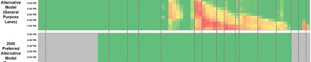
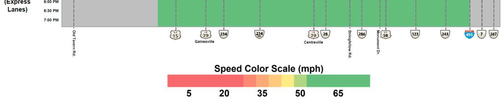
6 I-66 Open Section Traffic and Sensitivity Analysis Draft Memo Traffic Simulation Results - AM Peak The VISSIM microsimulation models were used to conduct the analysis for the 2040 base scenario for AM and PM peak networks to compare with the results of the Preferred Alternative. Figure 4 shows the speed congestion comparison of the Open Section scenario with the Preferred Alternative scenario between the I-495 interchange and Nutley Street for the AM peak period. It shows that with the base conditions for weaving volumes and driver behavior, this segment performs poorly in this segment. The additional lane changes required for vehicles to position themselves to access the existing ramps would result in traffic operations breakdown in the segment between Nutley Street and I-495 interchange. Note the speed graphics on the following pages compare the mini-model developed for this sensitivity analysis against the Preferred Alternative model. In order to optimize the number of model runs and scenarios assessed for this effort, the focus of the mini-model was centered around the study area between Nutley Street and I-495 interchange, so the speeds for the remaining portions of the corridor were not extracted/calculated, and show up as grey in the speed graphics. Transform 66 Outside the Beltway 6 MEMORANDUM

7 I-66 Open Section Traffic and Sensitivity Analysis Draft Memo Figure 4: I-66 Eastbound AM Peak Period - Speed Congestion Results Transform 66 Outside the Beltway 7 MEMORANDUM


.")
8 Figure 5 shows the detailed results by segment for the speeds and densities in the Open Section, using the standard templates developed by VDOT for reporting density and speeds, as provided in the Traffic Operations and Simulation Analysis Manual. It shows all segments along I-66 eastbound between the Nutley Street on-ramp and the I-495 off-ramps operating at a Level of Service (LOS) F equivalent (shown in red note that LOS is based on vehicular density). Figure 5: I-66 Eastbound AM Peak Hour Freeway Simulation Results Transform 66 Outside the Beltway 8 MEMORANDUM
9 Traffic Simulation Results - PM Peak The speed congestion comparisons shown in Figure 6 compare the results of the Open Section base scenario with the Preferred Alternative scenario between the Nutley Street and the I-495 interchange for the PM peak period. It shows that with the base conditions for weaving volumes and driver behavior, this segment performs poorly in this segment. The additional lane changes required for vehicles to position themselves to access the I-66 express lanes entrance and the Nutley Street ramps would result in traffic operations breakdown in the segment between I-495 and the Nutley Street interchange. Transform 66 Outside the Beltway 9 MEMORANDUM


10 Figure 6: I-66 Westbound PM Peak Period - Speed Congestion Results Transform 66 Outside the Beltway 10 MEMORANDUM


11 Figure 7 shows the detailed results by segment for the speeds and densities in the Open Section. It shows all segments along I-66 westbound between the I-495 on-ramps and the off-ramps to Nutley Street operating at a LOS F equivalent. Figure 7: I-66 Westbound PM Peak Hour Freeway Simulation Results Sensitivity Analysis Scenarios Apart from the base conditions described in the previous section, sensitivity testing was conducted, especially for the westbound PM peak hour conditions for the Open Section scenario, to assess the impact of incremental increases in predicted weaving volumes. Changes in weaving could happen for Transform 66 Outside the Beltway 11 MEMORANDUM
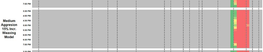
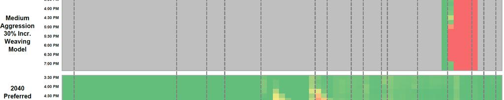
12 several reasons, such as an increase in Express lanes demand due to downstream incidents, etc. Also, this segment does not exist under current conditions and it is not possible to predict the aggressiveness of drivers, hence different levels of driver aggressiveness were tested. Table 1 below shows the different scenarios that were tested for the sensitivity analysis based on the weaving volumes and driver aggressiveness. Weaving Volumes Table 1: Sensitivity Analysis Scenarios Lower Aggressive (LA) Driver Aggressiveness Medium-Higher Aggressive (MA) Low Weave Base Conditions (LW) LW-LA LW-MA Medium Weave 15% increase (MW) MW-LA MW-MA High Weave 30% increase (HW) HW-LA HW-MA Weaving demand for different scenarios Figures 4 6 show the different weaving volumes that were tested for the westbound PM peak hour scenario with the Low being the base scenario weaving volumes and the medium representing a 15% increase in weaving volumes and high representing 30% increase in weaving volumes. The total demand was kept constant, only the proportion of weaving volume was increased for the medium and higher demand scenarios (representing the dynamic nature and variability of traffic flow during congested conditions). For each of these weaving volume scenarios, different levels of driver behavior with respect to aggressiveness to make lane changes were tested in this open section between the I-495 interchange and the Nutley Street interchange. Transform 66 Outside the Beltway 12 MEMORANDUM
13 Figure 8: Demand volumes for Low Weaving scenarios Transform 66 Outside the Beltway 13 MEMORANDUM
14 Figure 9: Demand volumes for Medium Weaving scenarios Transform 66 Outside the Beltway 14 MEMORANDUM

15 Figure 10: Demand volumes for High Weaving scenarios Transform 66 Outside the Beltway 15 MEMORANDUM
16 Traffic Simulation Results Table 2 describes the results of the sensitivity analysis. It shows that except for the High Aggressive Base Weaving Volumes (HA-LW) and High Aggressive Medium Weaving Volumes (HA-MW) scenarios, all others operate under Severe Congestion conditions with only the High Aggressive-High Weaving Volumes (HA-HW) working under a Mild Congestion level. Detailed traffic operations results are shows in the Appendix for all the scenarios. Table 2: Traffic Simulation Results (Westbound PM peak hour) Driver Aggressiveness Weaving Volumes Lower Aggressive (LA) Medium-Higher Aggressive (MA) Low Base Conditions (LW) Medium 15% increase (MW) High 30% increase (HW) - No congestion - Moderate congestion - Severe congestion It can be seen from these results that under most of the scenarios that were tested for the Open Section, the operating conditions are poor and would result in congestion and potential safety concerns. Transform 66 Outside the Beltway 16 MEMORANDUM
17 Safety Analysis The Open Section would create more weaving and merging than would otherwise occur under the Preferred Alternative where the Express Lanes have direct access through dedicated ramps and the section is separated by bollards from the general purpose lanes. As shown in Table 3, the minimum number of lane changes to satisfy any given movement in the I-66 eastbound Open Section is 15, compared to 9 for the Preferred Alternative. The minimum number of lane changes required to satisfy all movements in the I-66 westbound Open Section is 23, compared to 14 in the Preferred Alternative. Table 3: Minimum Number of Lane Changes for I-66 Eastbound Section Minimum Number of lane Changes Origin Destination Open Section Preferred Alternative I-495 SB 0 0 Route 243 (Nutley St) On-Ramp I-495 NB 1 1 I-495 Express 5 2 I-66 EB 2 2 I-495 SB 0 1 I-66 GP lanes I-495 NB 0 0 I-495 Express 2 3 I-66 EB 0 0 I-495 SB 3 0 I-66 Express Lanes I-495 NB 2 N/A I-495 Express 0 0 I-66 EB 0 0 Total 15 9 Transform 66 Outside the Beltway 17 MEMORANDUM
18 Table 4: Minimum Number of Lane Changes for I-66 Westbound Section Minimum Number of Lane Changes Origin Destination Open Section Preferred Alternative Route I-495 NB Express I-66 GP 2 2 I-66 Express 0 1 Route I-495 NB GP I-66 GP 0 2 I-66 Express 2 1 Route I-495 SB Express I-66 GP 0 0 I-66 Express 3 0 Route I-495 SB GP I-66 GP 1 0 I-66 Express 4 N/A Route I-66 I-66 GP 0 0 I-66 Express 0 1 Total These operational conditions would present safety challenges for drivers as they need to maneuver their way from general purpose lanes to the Express lanes and vice versa. Any increase in the number of lane changes by itself has the potential to proportionally impact safety conditions in this section. In addition, the open section would present noticeable speed differentials between the tolled lanes and the general purpose lanes. The simulation modeling shows that vehicles traveling on the Express Lanes on an average would travel between 10 to 15 miles per hour higher speed than those on the general purpose lanes. The speed differential would present a safety challenge for those vehicles merging from right to left when trying to access the Express Lanes. It has been proved that right to left merges require additional sight distance in order to accomplish a safe lane change as well as that drivers tend to be more conservative when determining the safe distance (time gap in the adjacent traffic flow) to attempt a lane change. The analysis clearly shows that the open section would fail operationally in those scenarios where a more conservative lane change behavior is assumed. Based on these safety considerations, a more conservative driver behavior is warranted in this section. Transform 66 Outside the Beltway 18 MEMORANDUM
19 APPENDIX RESULTS OF TRAFFIC OPERATIONS ANALYSIS Appendix A: Eastbound AM Open Section Results The section provides detailed results obtained from the eastbound AM open section analysis. These results demonstrate that an open section between Nutley Street and I-495 in the eastbound direction would be unable to adequately handle forecasted AM peak period demand. Transform 66 Outside the Beltway 19 MEMORANDUM


20 Figure A1: Freeway Schematic EB AM Transform 66 Outside the Beltway 20 MEMORANDUM
21 Figure A2: Freeway Schematic EB AM - Increased Weaving Transform 66 Outside the Beltway 21 MEMORANDUM
22 Figure A3: EB AM Peak Period - Speed Comparison Transform 66 Outside the Beltway 22 MEMORANDUM
23 Appendix B: Westbound PM Open Section Results The section provides detailed results obtained from the westbound PM open section analysis. These results demonstrate that, while the westbound open section may be capable of handling forecasted PM peak period demand volumes as straight through volumes (if weaving is not considered), it would be especially sensitive to sudden breakdowns in operations. Transform 66 Outside the Beltway 23 MEMORANDUM
24 Figure B1: PM Lower Aggressive - 15 Percent Weaving Transform 66 Outside the Beltway 24 MEMORANDUM


25 Figure B2: PM Lower Aggressive - 30 Percent Weaving Transform 66 Outside the Beltway 25 MEMORANDUM


26 Figure B3: PM Lower Aggressive - Base Weaving Transform 66 Outside the Beltway 26 MEMORANDUM
27 Figure B4: PM Lower Aggressive - Speed Comparison Transform 66 Outside the Beltway 27 MEMORANDUM
28 Figure B5: PM Medium-Higher Aggressive - 15 Percent Weaving Transform 66 Outside the Beltway 28 MEMORANDUM


29 Figure B6: PM Medium-Higher Aggressive - 30 Percent Weaving Transform 66 Outside the Beltway 29 MEMORANDUM
30 Figure B7: PM Medium-Higher Aggressive Base Weaving Transform 66 Outside the Beltway 30 MEMORANDUM

31 Figure B8: PM Medium-Higher Aggressive - Speed Comparison Transform 66 Outside the Beltway 31 MEMORANDUM
2006 WEEKDAY TRAFFIC PROFILE. June 15, 2007
 June 15, 2007 Mr. Gary Stobb, P.E. Director of Planning/Operations Harris County Toll Road Authority 330 Meadowfern, Suite 200 Houston, TX 77067 Re: Westpark Tollway Value Pricing Analysis Dear Mr. Stobb:
Transform66: Inside the Beltway
 Transform66: Inside the Beltway Result of a multi-year planning that started during the McDonnell Administration 2016 compromise reached with General Assembly Convert I-66 to express lanes from 5:30a-9:30a
FEASIBILITY STUDY REFINED CONCEPT 1 PROJECT A
 VIRGINIA DEPARTMENT OF TRANSPORTATION I-85 / I-95 INTERCHANGE FEASIBILITY STUDY REFINED CONCEPT 1 PROJECT A Columbia Rd REFINED CONCEPT 1 PROJECT A Bellevue Rd COST: $3.3M Siege Rd Eliminate the loop ramp
Arlington County Board Meeting Project Briefing. October 20, 2015
 Arlington County Board Meeting Project Briefing October 20, 2015 Project Map 2 Project Context Only Interstate in the Country limited to HOV only traffic during rush hours Stoplight at the end of I-66
Memorandum. Roger Millar, Secretary of Transportation. Date: April 5, Interstate 90 Operations and Mercer Island Mobility
 Memorandum To: From: The Honorable Dow Constantine, King County Executive; The Honorable Ed Murray, City of Seattle Mayor; The Honorable Bruce Bassett, City of Mercer Island Mayor; The Honorable John Stokes,
McLean Citizens Association Transportation Committee Project Briefing
 McLean Citizens Association Transportation Committee Project Briefing November 10, 2015 Project Map 2 Project Context Only Interstate in the Country limited to HOV only traffic during rush hours Stoplight
5.1 Traffic and Transportation
 5.1 When it opens in 2009, the Bellevue Nickel Improvement Project will increase the number of vehicles able to travel through the study area, improve travel speeds, and improve safety by reducing the
MEMORANDUM. Lynn Hayes LSA Associates, Inc.
 MEMORANDUM To: Lynn Hayes LSA Associates, Inc. Date: May 5, 217 From: Zawwar Saiyed, P.E., Senior Transportation Engineer Justin Tucker, Transportation Engineer I Linscott, Law & Greenspan, Engineers LLG
A. CONCLUSIONS OF THE FGEIS
 Chapter 11: Traffic and Parking A. CONCLUSIONS OF THE FGEIS The FGEIS found that the Approved Plan will generate a substantial volume of vehicular and pedestrian activity, including an estimated 1,300
APPENDIX J MODIFICATIONS PERFORMED TO THE TOR
 APPENDIX J MODIFICATIONS PERFORMED TO THE TOR This appendix summarizes the modifications that were performed in years 2012 and 2017 to rectify calculation errors that were observed in the data presented
NORTH FRASER PERIMETER ROAD WEST CORRIDOR DEFINITION STUDY
 NORTH FRASER PERIMETER ROAD WEST CORRIDOR DEFINITION STUDY MAY 2011 SW1132SWD NORTH FRASER PERIMETER ROAD WEST CORRIDOR DEFINITION STUDY TABLE OF CONTENTS 1.0 INTRODUCTION... 1 2.0 CURRENT TRAVEL PATTERNS
Interstate 90 and Mercer Island Mobility Study APRIL Commissioned by. Prepared by
 Interstate 90 and Mercer Island Mobility Study APRIL 2017 Commissioned by Prepared by Interstate 90 and Mercer Island Mobility Study Commissioned by: Sound Transit Prepared by: April 2017 Contents Section
SANTA CLARA COUNTY I-280 CORRIDOR STUDY
 SANTA CLARA COUNTY I-280 CORRIDOR STUDY Appendix B 2 Technical Memorandum Existing Transportation Condition Memo SANTA CLARA VALLEY TRANSPORTATION AUTHORITY (VTA) 1-1 Introduction The I-280 Corridor Study
PDF compression, OCR, web optimization using a watermarked evaluation copy of CVISION PDFCompressor
 o U.S. Department Washington Division Suite 501 Evergreen Plaza of Transportation 711 South Capitol Way Olympia, Washington 98501-1284 Federa' Highway (360) 753-9480 Administration (360) 753-9889 (FAX)
DISTRICT EXPRESS LANES ANNUAL REPORT FISCAL YEAR 2017 JULY 1, 2016 JUNE 30, FloridaExpressLanes.com
 DISTRICT EXPRESS LANES ANNUAL REPORT FISCAL YEAR 2017 JULY 1, 2016 JUNE 30, 2017 FloridaExpressLanes.com This page intentionally left blank. TABLE OF CONTENTS List of Figures... ii List of Tables.... ii
TABLE OF CONTENTS. Coral Springs Charter High School and Middle School Job No Page 2
 Job No. 15-019 Page 2 TABLE OF CONTENTS 1.0 INTRODUCTION... 4 2.0 EXISTING CONDITIONS... 5 3.0 TRAFFIC GENERATION... 7 4.0 TRIP DISTRIBUTION... 8 5.0 FUTURE CONDITIONS... 8 6.0 SITE ACCESS...13 7.0 CONCLUSION...13
HOV LANE PERFORMANCE MONITORING: 2000 REPORT EXECUTIVE SUMMARY
 Final Report Research Project Agreement No. T1803, Task 4 HOV Monitoring V HOV LANE PERFORMANCE MONITORING: 2000 REPORT EXECUTIVE SUMMARY by Jennifer Nee TRAC Research Engineer John Ishimaru TRAC Senior
1.2 Corridor History and Current Characteristics
 SECTION 1 Description and Background of Study Area 1.1 Introduction This preliminary engineering report was prepared for the Alaska Department of Transportation and Public Facilities (ADOT&PF). It is part
Traffic Analysis Final Report
 SR-71 Widening Project Project Approval/Environmental Documentation Traffic Analysis Final Report Prepared for Caltrans District 7 August 2012 6 Hutton Centre Drive, Suite 700 Santa Ana, California 92707
INTERSTATE 395 EXPRESS LANES NORTHERN EXTENSION TRAFFIC & TRANSPORTATION TECHNICAL REPORT SEPTEMBER 2016
 INTERSTATE 395 EXPRESS LANES NORTHERN EXTENSION TRAFFIC & TRANSPORTATION TECHNICAL REPORT SEPTEMBER 2016 INTERSTATE 395 EXPRESS LANES NORTHERN EXTENSION Traffic and Transportation Technical Report City
APPENDIX H MILESTONE 2 TRAFFIC OPERATIONS ANALYSIS OF THE AT-GRADE CROSSINGS
 Draft Environmental Impact Statement/Environment Impact Report Appendix H Milestone 2 Traffic Operations Analysis of the At-Grade Crossings APPENDIX H MILESTONE 2 TRAFFIC OPERATIONS ANALYSIS OF THE AT-GRADE
Treasure Island Supplemental Information Report Addendum
 1 1 1 1 0 1 0 1 0 1 Treasure Island Supplemental Information Report Addendum Introduction Purpose The purpose of this Supplemental Information Report (SIR) Addendum is to determine if the current land
Watts St westbound thru
 Executive Summary At the request of the Hudson Square Business Improvement District, Sam Schwartz Engineering, DPC (Sam Schwartz) has completed a technical analysis of various congestion pricing and/or
Public Information Meetings. October 5, 6, 7, and 15, 2015
 Public Information Meetings October 5, 6, 7, and 15, 2015 Project Map 2 Project Context Only Interstate in the Country limited to HOV only traffic during rush hours Stoplight at the end of I-66 eastbound
CONTACT: Michelle T. Holland
 FOR IMMEDIATE RELEASE Thursday, December 7, 2017 CONTACT: Michelle T. Holland 703-586-0487 (C) Michelle.Holland@vdot.virginia.gov Jennifer McCord 571-230-2926 Jennifer.McCord@vdot.virginia.gov 66 EXPRESS
2014 PERFORMANCE OF HIGH-OCCUPANCY VEHICLE FACILITIES ON FREEWAYS IN THE WASHINGTON REGION
 2014 PERFORMANCE OF HIGH-OCCUPANCY VEHICLE FACILITIES ON FREEWAYS IN THE WASHINGTON REGION Travel Forecasting Subcommittee Friday, May 22, 2015 C. Patrick Zilliacus Figure 1 HOV System Overview Montgomery
FIRST WEEK UPDATE: 66 EXPRESS LANES INSIDE THE BELTWAY Data from first four days shows faster, more reliable trips on I-66
 FOR IMMEDIATE RELEASE Tuesday, December 12, 2017 CONTACT: Michelle T. Holland 703-586-0487 (C) Michelle.Holland@vdot.virginia.gov Jennifer McCord 571-230-2926 Jennifer.McCord@vdot.virginia.gov FIRST WEEK
LUDWIG RD. SUBDIVISION PROJECT TRAFFIC IMPACT ANALYSIS
 LUDWIG RD. SUBDIVISION PROJECT TRAFFIC IMPACT ANALYSIS Prepared for Skip Coddington GSC Development, Inc PO Box 1623 Woodinville WA 9872 Prepared by 1141 NE 124 th St., #59 Kirkland, WA 9834 425.522.4118
FIRST WEEK UPDATE: 66 EXPRESS LANES INSIDE THE BELTWAY Data from first four days shows faster, more reliable trips on I-66
 Subject: FIRST WEEK UPDATE: 66 EXPRESS LANES INSIDE THE BELTWAY From: VDOT-News To: Time: Tuesday, December 12, 2017 9:05:36 AM -08:00 RELEASE: IMMEDIATE Michelle Holland,
Design Public Hearing
 Design Public Hearing Monday, March 7, 2016 Washington-Lee High School Cafeteria 1301 N. Stafford Street, Arlington, VA 22201 Tuesday, March 8, 2016 Eagle Ridge Middle School Cafeteria 42901 Waxpool Road,
I-66 Inside the Beltway Feasibility Study
 I-66 Inside the Beltway Feasibility Study Feasibility Study Study Process Context Sensitive Dialogues Corridor Assessments / Data Collection Problem Statement Refinement Concept Development Concept Evaluation
10.0 Recommendations Methodology Assumptions
 10.0 Recommendations To accommodate the projected growth of the I-526 corridor, this report has summarized potential improvement strategies that were separated into four categories, TDM, Modal, Traffic
Appendix 4.1 J. May 17, 2010 Memorandum from CTPS to the Inter Agency Coordinating Group
 Appendix 4.1 J May 17, 2010 Memorandum from CTPS to the Inter Agency Coordinating Group CTPS CENTRAL TRANSPORTATION PLANNING STAFF Staff to the Boston Region Metropolitan Planning Organization MEMORANDUM
Research Report Agreement T4118, Task 24 HOV Action Plan HOV ACTION PLAN
 Research Report Agreement T4118, Task 24 HOV Action Plan HOV ACTION PLAN by John M. Ishimaru Senior Research Engineer Duane Wright Systems Analyst Programmer Mark E. Hallenbeck Director Jaime Kang Research
Transportation Improvement District (TID) Exercise New Castle County Unified Development Code
 Exercise New Castle County Unified Development Code") Transportation Improvement District (TID) Exercise New Castle County Unified Development Code Churchmans Crossing TID How should New Castle County deploy Transportation Improvement Districts (TIDs)? Site
Transportation Improvement District (TID) Exercise New Castle County Unified Development Code Churchmans Crossing TID How should New Castle County deploy Transportation Improvement Districts (TIDs)? Site
Texas Transportation Institute The Texas A&M University System College Station, Texas
 1. Report No. FHWA/TX-05/0-4434-P1 2. Government Accession No. 3. Recipient's Catalog No. 4. Title and Subtitle GUIDANCE FOR FUTURE DESIGN OF FREEWAYS WITH HIGH- OCCUPANCY VEHICLE (HOV) LANES BASED ON
CALIFORNIA HIGH-OCCUPANCY VEHICLE LANE DEGRADATION ACTION PLAN
 CALIFORNIA DEPARTMENT OF TRANSPORTATION CALIFORNIA HIGH-OCCUPANCY VEHICLE LANE DEGRADATION ACTION PLAN Prepared by Division of Traffic Operations Office of Traffic Management Submitted to Federal Highway
STUDY DESCRIPTION MEMORANDUM. DATE April 20, 2011
 DATE April 0, 0 TO FROM RE MEMORANDUM Congestion Management Program Files Ariel Godwin, CMP Manager Boston Region MPO Staff Limited-Access Highway Counts and Traffic Volumes, Summer 00 This memorandum
Report to the Strategic Development Committee
 Report to the Strategic Development Committee Request of Virginia Department of Transportation for Easements across Washington Dulles International Airport Property at Route 28 May 2016 PURPOSE Staff requests
Memorandum. Fund Allocation Fund Programming Policy/Legislation Plan/Study Capital Project Oversight/Delivery Budget/Finance Contract/Agreement Other:
 Memorandum Date: March 23, 2018 To: Transportation Authority Board From: Eric Cordoba Deputy Director Capital Projects Subject: 4/10/18 Board Meeting: San Francisco Freeway Corridor Management Study Update
ROUTE 20 CORRIDOR STUDY ---- Orange County, Virginia
 ROUTE 20 CORRIDOR STUDY ---- Orange County, Virginia Prepared by PARSONS Fairfax, Virginia on behalf of the: Rappahannock-Rapidan Regional Commission in cooperation with Orange County, Virginia Virginia
ROUTE 630 DIVERGING DIAMOND INTERCHANGE
 ROUTE 630 DIVERGING DIAMOND INTERCHANGE Virginia Department of Transportation Contract Value and Dates Contract Value: $99,949,969.50 Start of Construction: Summer 2017 Final Completion Date: July 31,
MEMORANDUM. Bob Zagozda, Chief Financial Officer Westside Community Schools. Mark Meisinger, PE, PTOE Felsburg Holt & Ullevig. DATE: June 11, 2018
 MEMORANDUM TO: Bob Zagozda, Chief Financial Officer Westside Community Schools FROM: Mark Meisinger, PE, PTOE Felsburg Holt & Ullevig DATE: June 11, 218 6-11-18 SUBJECT: Sunset Hills Elementary School
FREDERICKSBURG DISTRICT. District Engineer Marcie Parker, P.E. May 8, 2018
 FREDERICKSBURG DISTRICT District Engineer Marcie Parker, P.E. May 8, 2018 3 Interstate 95 Projects Fredericksburg Area Fredericksburg region will see greatest degree of I-95 construction since widening
AGENDA ITEM I-6 Public Works
 AGENDA ITEM I-6 Public Works STAFF REPORT City Council Meeting Date: 8/6/2018 Staff Report Number: 18-150-CC Informational Item: Update on the Willow Road and highway 101 interchange construction, upcoming
Lake Erie Commerce Center Traffic Analysis
 LOCATION: East of NYS Route 5 at Bayview Road Town of Hamburg Erie County, New York PREPARED BY: Wendel Companies 140 John James Audubon Parkway Suite 200 Amherst, New York 14228 January 2012 i ii Table
Aldridge Transportation Consultants, LLC Advanced Transportation Planning and Traffic Engineering
 Aldridge Transportation Consultants, LLC Advanced Transportation Planning and Traffic Engineering John M.W. Aldridge, PE, PTOE, AICP 182 Chimney Rock Road Colorado Registered Professional Engineer Highlands
Yonge Street / Highway 401 Improvements Update. Public Works and Infrastructure Committee. General Manager, Transportation Services
 PW9.7 STAFF REPORT ACTION REQUIRED Yonge Street / Highway 401 Improvements Update Date: October 26, 2015 To: From: Wards: Reference Number: Public Works and Infrastructure Committee General Manager, Transportation
EXISTING CONDITIONS A. INTRODUCTION. Route 107 Corridor Study Report
 II. EXISTING CONDITIONS A. INTRODUCTION The Route 107 study area extends from the south at Chestnut Street in Lynn approximately 3.7 miles to the north to Boston Street in Salem. The study area has three
Section 106 Update Memo #1 Attachment D. Traffic Diversion & APE Expansion Methodology & Maps
 Section 106 Update Memo #1 Attachment D Traffic Diversion & APE Expansion Methodology & Maps I-65/I-70 North Split Interchange Reconstruction Project (Des. Nos. 1592385 & 1600808) Traffic Diversion and
HDR itrans Consulting Inc. 100 York Blvd., Suite 300 Richmond Hill, ON L4B 1J8 Tel: (905) Fax: (905)
 Fax: (905)") !" # $ !" # $ Consulting Inc. 100 York Blvd., Suite 300 Richmond Hill, ON L4B 1J8 Tel: (905) 882-4100 Fax: (905) 882-1557 www.itransconsulting.com November 2009 %&'('$&$ 1. West Brampton Road Network...
!" # $ !" # $ Consulting Inc. 100 York Blvd., Suite 300 Richmond Hill, ON L4B 1J8 Tel: (905) 882-4100 Fax: (905) 882-1557 www.itransconsulting.com November 2009 %&'('$&$ 1. West Brampton Road Network...
MEMORANDUM. for HOV Monitoring on I-93 North and the Southeast Expressway, Boston Region MPO, November, 2011.
 MEMORANDUM Date: January 12, 2012 To: Congestion Management Process Files From: Seth Asante, Ryan Hicks, and Efi Pagitsas MPO Staff Re: Historical Trends: Travel Times and Vehicle Occupancy Levels for
ROUTE 122 CORRIDOR STUDY ---- Bedford County and Bedford City, Virginia
 ROUTE 122 CORRIDOR STUDY ---- Bedford County and Bedford City, Virginia Developed by Region 2000 Regional Commission In cooperation with Bedford County, Virginia City of Bedford, Virginia Virginia Department
CENTRAL OREGON REGIONAL TRANSIT MASTER PLAN
 Central Oregon Regional Transit Master Plan Volume II: Surveys and Market Research CENTRAL OREGON REGIONAL TRANSIT MASTER PLAN Volume IV: Service Plan Appendices A-B July 213 Nelson\Nygaard Consulting
A retrospective look at work program counting activities since 2001 is found in Table 8, on the last page of this document. Hours of Operation
 Page 2 of 20 Background TPB staff has been managing data collection along the region s HOV facilities since the late 1990's, and documenting the results, which include counts of auto occupants, vehicles
Southern Oregon Transportation Engineering, LLC
 Southern Oregon Transportation Engineering, LLC 112 Monterey Drive - Medford, Or. 97504 Office 541.608.9923 Cell 541.941.4148 Email: Kwkp1@Q.com August 12, 2013 Mike Faught, Public Works Department City
Pedestrian Safety Review Spadina Avenue
 STAFF REPORT ACTION REQUIRED Pedestrian Safety Review Spadina Avenue Date: October 13, 2015 To: Toronto and East York Community Council From: Director, Transportation Services, Toronto and East York District
Arlington County Board Work Session Eastbound Widening January 17, Amanda Baxter, VDOT Special Projects Development Manager
 Arlington County Board Work Session Eastbound Widening January 17, 2017 Amanda Baxter, VDOT Special Projects Development Manager Program Area Map 2 Program Scope Tolling during weekdays, peak hours, peak
A VISION FOR I-95. January 12, Delaware Department of Transportation
 A VISION FOR I-95 January 12, 2011 Delaware Department of Transportation The East Coast s Main Street Along with SR 1, the most significant highway in Delaware 29 miles to I ".', 2 Sponsoring / Cooperating
WELCOME TO THE OPEN HOUSE
 WELCOME TO THE OPEN HOUSE US 281 North Loop 1604 to Borgfeld Drive CSJ: 0253-04-146 & 0253-04-138 May 12, 2016 Please sign in Explore the exhibits Submit a comment form Ask questions We want to know your
CITY MANAGER S OFFICE CITY OF MERCER ISLAND, WASHINGTON 9611 SE 36 th Street Mercer Island, WA (206)
") CITY MANAGER S OFFICE CITY OF MERCER ISLAND, WASHINGTON 9611 SE 36 th Street Mercer Island, WA 98040-3732 (206) 275-7600 www.mercergov.org August 18, 2016 Mr. Daniel M. Mathis Division Administrator Federal
CITY MANAGER S OFFICE CITY OF MERCER ISLAND, WASHINGTON 9611 SE 36 th Street Mercer Island, WA 98040-3732 (206) 275-7600 www.mercergov.org August 18, 2016 Mr. Daniel M. Mathis Division Administrator Federal
INTERSTATE 10 AND INTERSTATE 17 SPINE WORKSHOP
 October 31, 2012 INTERSTATE 10 AND INTERSTATE 17 SPINE WORKSHOP ADOT FHWA MAG City of Phoenix City of Tempe City of Chandler Valley Metro/RPTA October 31, 2012 1 Agenda Introductions Background Purpose
Launceston City Council. Kings Meadows Traffic Management Report for Public Consultation
 Launceston City Council Kings Meadows Traffic Management Report for Public Consultation November 2013 This report: has been prepared by GHD for Launceston City Council and may only be used and relied on
Elected Officials and Media Briefing I-395 Express Lanes Northern Extension
 Elected Officials and Media Briefing I-395 Express Lanes Northern Extension Updates on: I-95 Express Lanes Southern Extension Transform 66: Inside and Outside the Beltway March 31, 2016 Today s Agenda
Important Lane Closures, April 3 9, 2011
 March 31, 2011 CONTACT: Marcia McAllister T: 703 572 0506 C: 571 730 9117 marcia.mcallister@dullesmetro.com Important Lane Closures, April 3 9, 2011 RESCHEDULED: Lane Shifts of Westbound Route 7 at Route
Appendix 4.1 L. No-Build Project Descriptions
 Appendix 4.1 L No-Build Project Descriptions No-Build Projects New Bedford A new traffic signal system was installed and activated in early 2009 at the intersection of King s Highway and Mount Pleasant
PURPOSE AND NEED (CONCURRENCE POINT 1) NEW CANADA ROAD PROJECT FROM STATE ROUTE 1 (U.S. HIGHWAY 70) TO U.S. INTERSTATE 40
 NEW CANADA ROAD PROJECT FROM STATE ROUTE 1 (U.S. HIGHWAY 70) TO U.S. INTERSTATE 40") PURPOSE AND NEED (CONCURRENCE POINT 1) NEW CANADA ROAD PROJECT FROM STATE ROUTE 1 (U.S. HIGHWAY 70) TO U.S. INTERSTATE 40 Project Description The primary purpose of this project is to improve the major
PURPOSE AND NEED (CONCURRENCE POINT 1) NEW CANADA ROAD PROJECT FROM STATE ROUTE 1 (U.S. HIGHWAY 70) TO U.S. INTERSTATE 40 Project Description The primary purpose of this project is to improve the major
UNION STATION ACCESS AND CAPACITY IMPROVEMENT STUDY PROJECT REPORT
 UNION STATION ACCESS AND CAPACITY IMPROVEMENT STUDY PROJECT REPORT Washington Metropolitan Area Transit Authority Department of Planning and Joint Development In Association with District of Columbia Department
TRAFFIC & PARKING STUDY FOR PROPOSED BIRMINGHAM BOUTIQUE HOTEL
 TRAFFIC & PARKING STUDY FOR PROPOSED BIRMINGHAM BOUTIQUE HOTEL Prepared for LORIENT CAPTIAL LLC Birmingham, MI By GIFFELS WEBSTER Washington Township, MI April 2017 i CONTENTS EXECUTIVE SUMMARY. ii INTRODUCTION.
7272 WISCONSIN AVENUE LOCAL AREA TRANSPORTATION REVIEW
 7272 LOCAL AREA TRANSPORTATION REVIEW AND TRANSPORTATION POLICY AREA REVIEW MONTGOMERY COUNTY, MARYLAND Submitted on behalf of Carr Properties Prepared by: Wells + Associates, Inc. Submission: July 1,
Metro ExpressLanes April 5, 2011 Community Meeting re: Adams Blvd Improvements
 Metro ExpressLanes April 5, 2011 Community Meeting re: Adams Blvd Improvements Jan Perry Councilwoman, District 9 Welcome Remarks Arthur T. Leahy Chief Executive Officer, Metro Metro ExpressLanes Overview
I-94 East Corridor Performance
 Corridor Context The corridor runs 16 miles between downtown St. Paul and the Wisconsin state border. The corridor serves as an important East-West connection for the Metro area, serving the communities
Fairfax County Transportation Advisory Commission (TAC)
") Fairfax County Transportation Advisory Commission (TAC) January 17, 2017 Susan Shaw, P.E., Megaprojects Director Virginia Department of Transportation Amanda Baxter, Special Projects Development Manager
Fairfax County Transportation Advisory Commission (TAC) January 17, 2017 Susan Shaw, P.E., Megaprojects Director Virginia Department of Transportation Amanda Baxter, Special Projects Development Manager
TfL Planning. 1. Question 1
 TfL Planning TfL response to questions from Zac Goldsmith MP, Chair of the All Party Parliamentary Group on Heathrow and the Wider Economy Heathrow airport expansion proposal - surface access February
FHWA P/N Guidelines. Corridor Relationship. Highway 22 Segment 1 - US 169 to CSAH 2 Relevance / Documentation of Need
 Highway 22 Segment 1 - US 169 to CSAH 2 Vehicle Mobility Congestion Intersection Congestion Existing Conditions - Based on Highway Capacity Manual methodology, corridor level of service is currently LOS
Freymond Aggregates Quarry Bay Lake Rd., Twp. of Faraday
 Freymond Aggregates Quarry Bay Lake Rd., Twp. of Faraday Traffic Brief South Site Entrance Prepared by: Tranplan Associates PO Box 455 Lakefield, ON K0L 2H0 www.tranplan.com Prepared for: EcoVue Consulting
3 ASSESSMENT OF THE CORRIDOR
 3 ASSESSMENT OF THE CORRIDOR 3.1 PHYSICAL CHARACTERISTICS OF THE CORRIDOR The 9-mile segment of I-66 from the Capital Beltway to the Theodore Roosevelt Memorial Bridge was opened to vehicular traffic in
KING STREET TRANSIT PILOT
 KING STREET TRANSIT PILOT Update toronto.ca/kingstreetpilot #kingstreetpilot HIGHLIGHTS TRANSIT RIDERSHIP TRANSIT CAPACITY To respond to this growth in ridership, the TTC has increased the capacity of
Eleven things you should know about the carpool lanes in Los Angeles County.
 Eleven things you should know about the carpool lanes in Los Angeles County. Los Angeles County Metropolitan Transportation Authority One Gateway Plaza Los Angeles, CA 912 COMPANY NAME Street Address City,
HAMPTON ROADS CROSSINGS PATRIOTS CROSSING AND HRBT
 HRTPO Board Meeting March 21, 2013 Agenda ITEM #9: HAMPTON ROADS CROSSINGS PATRIOTS CROSSING AND HRBT Congestion at the Hampton Roads Bridge-Tunnel (HRBT) on I-64 has long been identified as a problem
Freeway Volume-Crash Summary
 Freeway Volume-Crash Summary Twin Cities Metropolitan Area Continuation Report 22 Data Minnesota Department of Transportation Office of Traffic, Security and Operations Freeway Operations Section Regional
TRAFFIC IMPACT STUDY REPORT FOR PROPOSED OFFICE PROJECT AT 959 SEWARD STREET IN HOLLYWOOD SNYDER PARTNERS
 DRAFT TRAFFIC IMPACT STUDY REPORT FOR PROPOSED OFFICE PROJECT AT 959 SEWARD STREET IN HOLLYWOOD Prepared for: SNYDER PARTNERS Prepared by: Crain & Associates 2007 Sawtelle Boulevard, Suite 4 Los Angeles,
Capital Beltway HOT Lanes Project
 New Travel Choices Ahead Some things can t wait for traffic Capital Beltway HOT Lanes Project Project Update August 16, 2011 Major Milestones Reached Some things can t wait for traffic Project over 75%
Table of Contents. List of Tables
 Table of Contents 1. Introduction... 1 2. Service Recommendations... 1 A. Extend Service on Fort Belvoir to New Post Exchange/Commissary Complex... 1 B. Improve Service Frequencies on Sunday from Current
Washington St. & Ash Coulee Dr./43 rd Ave Intersection Study
 430 IACC Building Fargo, ND 58105 Tel 701-231-8058 Fax 701-231-1945 www.ugpti.org www.atacenter.org Washington St. & Ash Coulee Dr./43 rd Ave Intersection Study Final Report April 2007 Prepared for: City
3 Level of Service Results: Freeways and Arterials
 3 Level of Service Results: Freeways and Arterials This section presents a summary of LOS results for the freeways, ramps and arterials (Tier 1 and Tier 2 CMP network). In general, the number of congested
Mercer SCOOT Adaptive Signal Control. Karl Typolt, Transpo Group PSRC RTOC July 6th, 2017
 Mercer SCOOT Adaptive Signal Control Karl Typolt, Transpo Group PSRC RTOC July 6th, 2017 Our mission, vision, and core values Mission: deliver a high-quality transportation system for Seattle Vision: connected
Washington State Transportation Commission
 Washington State Transportation Commission I-405 express toll lanes Patty Rubstello, Assistant Secretary of Tolling May 17, 2016 Agenda I-405 Six Month Update Key Takeaways Performance update Impact to
FNORTHWEST ARKANSAS WESTERN BELTWAY FEASIBILITY STUDY
 FNORTHWEST ARKANSAS WESTERN BELTWAY FEASIBILITY STUDY EXECUTIVE SUMMARY The 2030 Northwest Arkansas Regional Transportation Plan developed by the Northwest Arkansas Regional Planning Commission (NWARPC)
77 McDonnell-Lindbergh - Monday thru Friday NORTHBOUND Effective: March 18, Shopping Center North County. Shopping Center Washington &
 77 McDonnell- - Monday thru Friday NORTHBOUND Effective: March 18, 2019 & Valley Industries 4:53A 4:59A 5:10A 5:18A 5:27A 5:39A 5:33A 5:39A 5:50A 5:58A 6:07A 6:19A 6:13A 6:19A 6:31A 6:39A 6:49A 7:02A 6:53A
Our Panelists SPEAKERS MODERATOR
 SPEAKERS Our Panelists Jennifer Aument, Transurban Gary Garczynski, Commonwealth Transportation Board Russ Gestl, Buchanan Partners, LLC Robert Shue, JLL MODERATOR David Birtwistle, Northern Virginia Transportation
V. DATA COLLECTION PROGRAM
 V. DATA COLLECTION PROGRAM As discussed in Section IV, an extensive data assembly and data collection program was undertaken to develop the data necessary to calibrate the existing Portway Extensions model
Kingston Transportation Master Plan Draft Report Transit Forecasting 1
 TRANSIT FORECASTING Transit Forecasting 1 INTRODUCTION A spreadsheet model was developed to identify existing transit deficiencies and additional transit service requirements. The model comprised transit
Interstate 95 / Scudder Falls Bridge Traffic Study
 Technical Memorandum Interstate 95 / Scudder Falls Bridge Traffic Study September 2004 Delaware Valley Regional Planning Commission The Bourse Building 111 South Independence Mall East Philadelphia, PA
Alternatives Analysis City of Newport Beach Sunset Ridge Park Project December 14, 2011
 Alternatives Analysis City of Newport Beach Sunset Ridge Park Project December 14, 2011 Alternatives Analysis for Vehicular Access: This report supplements the project s certified EIR s Alternatives Analysis.
Sky Temporary Car Park Transport Statement
 001 Issue 26 August 2016 This report takes into account the particular instructions and requirements of our client. It is not intended for and should not be relied upon by any third party and no responsibility
San Mateo County Transportation Authority Board Meeting November 2, 2017 Item #10 1
 San Mateo County Transportation Authority Board Meeting November 2, 2017 Item #10 1 OVERVIEW Brief recap from October Traffic Analysis Findings Draft Environmental Document Summarized Outcomes Questions
95 Express Lanes: Before/After Study
 95 Express Lanes: Before/After Study Exit 126 (Massaponax) to Exit 170 (Springfield) Before After 2010 2012 2015 Pictures show the Route 619 Interchange prior to the constructions of the Express Lanes,
Road School. Project Overview. March 8, 2011
 Road School March 8, 2011 Project Overview Roadway upgraded to freeway standards 13 miles of US 31 from I-465 to 216th Street Construction to begin in 2011 @ SR 38 and 146 th St Construction complete in
Fairfax County Parkway Widening Fairfax County
 Get Involved VDOT representatives will review and evaluate information received as a result of this meeting. Please fill out the comment sheet provided in this brochure if you have any comments or questions.