Welsh Assembly Government Transport Wales New M4 Project - Magor to Castleton Contents Page 1 INTRODUCTION 1 2 OPTIONS CONSIDERED Intermediate J
|
|
|
- Bennett Barnett
- 6 years ago
- Views:
Transcription
1 Welsh Assembly Government Transport Wales New M4 Project - Magor to Castleton April 2006 This report takes into account the particular instructions and requirements of our client. It is not intended for and should not be relied upon by any third party and no responsibility is undertaken to any third party 4 Pierhead Street, Capital Waterside, Cardiff CF10 4QP Tel +44 (0) Fax +44 (0) Job number
2 Welsh Assembly Government Transport Wales New M4 Project - Magor to Castleton Contents Page 1 INTRODUCTION 1 2 OPTIONS CONSIDERED Intermediate Junction Options Direct Link To A Eastern Junction Connecting into Nash Road and Meadows Road Eastern Junction Connecting into Meadows Road Only Eastern Junction Connecting into Meadows Road with a Possible Link to Corporation Road Western Junction Connecting to A48 East of LG Factory Western Junction with Connection to the A48 via Duffryn Link Road 6 3 TRAFFIC ASSESSMENT OF JUNCTION OPTIONS Interim Traffic Model No Intermediate Junctions Eastern Junction Connecting into Meadows Road Only Eastern Junction Connecting into Meadows Road with a Possible Link to Corporation Road Eastern Junction Connecting into Meadows Road with a Possible Link to Corporation Road and Western Connection to A48 via Duffryn Link Road Comments on Traffic Assessments Initial Assessment of the Impact of Tolling the New M ECONOMIC EVAULATION Basis of Transport User Benefit Appraisal (TUBA) Assumptions Used in TUBA Evaluation Output of TUBA 12 5 JUNCTION STRATEGY: OVERALL SUMMARY 14 J:\117000\ \4 INT PROJ DATA\4-50 REPORTS\ JUNCTION STRATEGY REVIEW\0002 JUNCTION STRATEGY REVIEW FINAL.DOC 06/ Final : April 2006
3 Welsh Assembly Government Transport Wales New M4 Project - Magor to Castleton Figures Figure 1.1 Figure 1.2 Figure 2.1 Figure 3.1 Figure 3.2 Figure 3.3 Figure 3.4 Illustrative Magor/Rogiet Interchange and Magor Junction Illustrative Castleton Interchange and Western Intermediate Junction Illustrative Eastern Intermediate Junction 2013 and 2028 Traffic Forecasts with No Intermediate Junction on New M and 2028 Traffic Forecasts with Eastern Intermediate Junction on New M4 Connecting into Meadows Road 2013 and 2028 Traffic Forecasts with Eastern Intermediate Junction on New M4 Connecting into Meadows Rd with a Possible Link to Corporation Rd 2013 and 2028 Traffic Forecasts with Eastern Intermediate Junction on New M4 Connecting into Meadows Rd with a Possible Link to Corporation Rd and Western Connection to A48 Appendix A Figure A.1 Figure A.2 Figure A.3 Figure A.4 Figure A.5 Figure A.6 Direct Link to A449 Eastern Junction Connecting into Nash Road and Meadows Road Eastern Junction Connecting into Meadows Road Only Eastern Junction Connecting into Meadows Road with a Possible Link to Corporation Road Western Junction Connecting To A48 East of LG Factory Western Junction Connecting To A48 via Duffryn Link Road Figures Figure 1 Figure Description J:\117000\ \4 INT PROJ DATA\4-50 REPORTS\ JUNCTION STRATEGY REVIEW\0002 JUNCTION STRATEGY REVIEW FINAL.DOC 06/ Final : April 2006
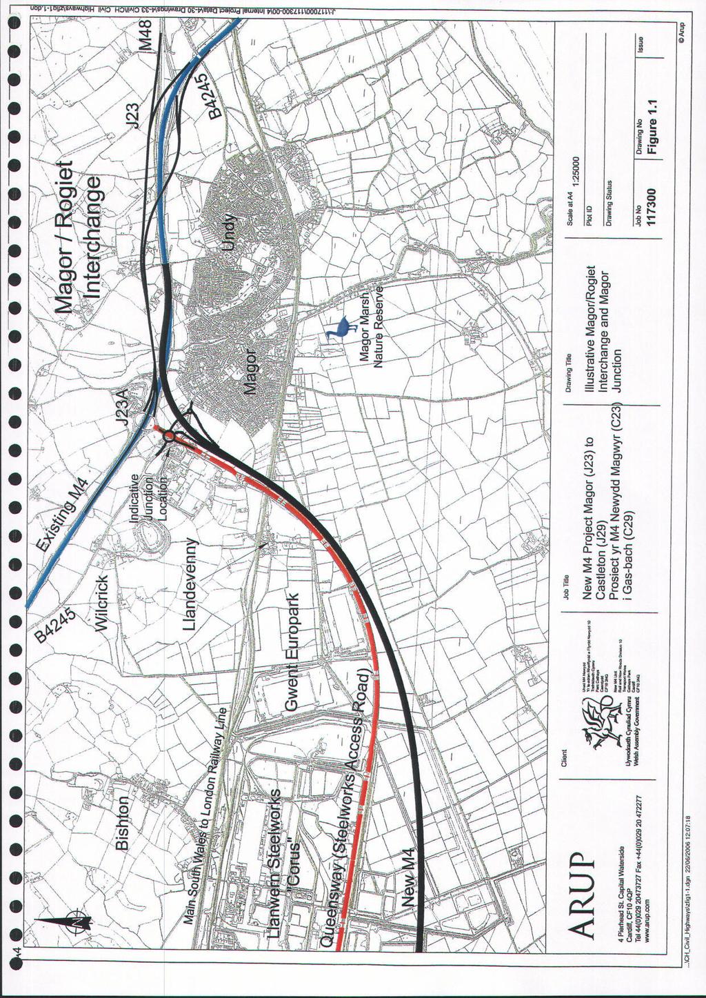
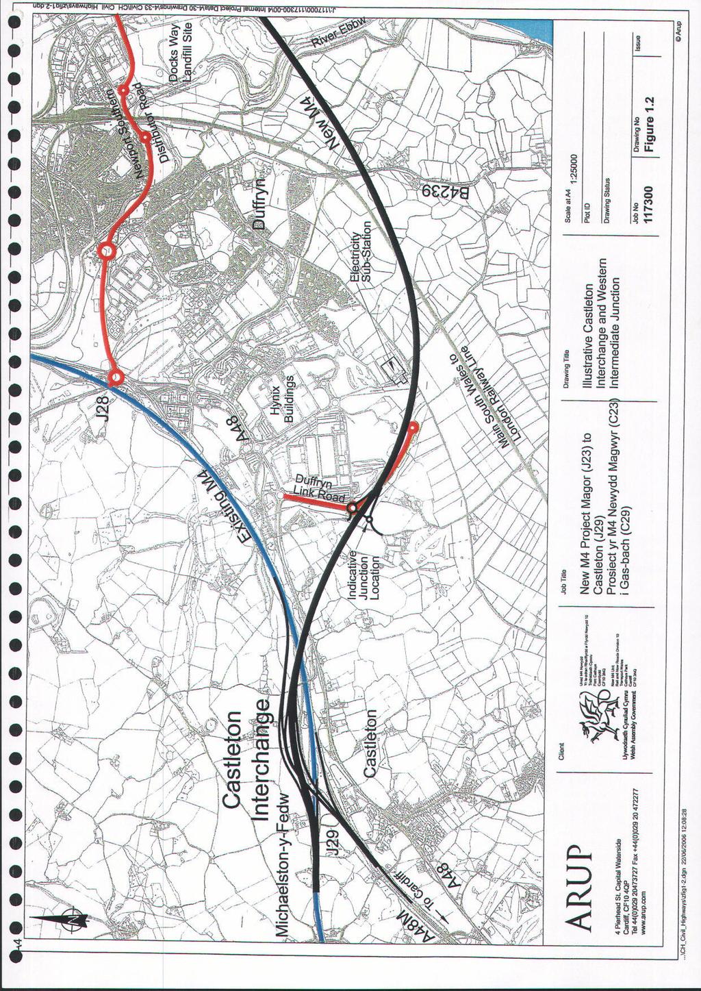
4 Transport Wales Welsh Assembly Government New M4 Project - Magor to Castleton 1 INTRODUCTION The Business Case for the New M4 will need to take into account possible locations for junctions. Preliminary consultations with Newport City Council and Monmouthshire County Council have set the scene in terms of land use development plans. At Magor - Rogiet and Castleton, free flowing interchanges have been developed. At Magor - Rogiet, value engineering developments have led to revisions to the details presented at Public Consultation (Autumn 1994) and necessitated a change to the published route corridor. The revised Magor - Rogiet Interchange arrangement incorporates west-facing slip roads linking the New M4 to the B4245 to the west of Magor. The previously published Castleton Interchange arrangement and the revised Magor - Rogiet arrangement have been included as preferred proposals in this junction strategy review, although it should be noted that further value engineering work is planned for both interchanges. It is planned to present the preferred interchange arrangements to the public and other stakeholders as part of the forthcoming Public Information Exhibitions; they are shown diagrammatically in Figures 1.1 and 1.2. This report summarises a review of options for intermediate junctions along the New M4. The review has broadly covered the following: general engineering feasibility related to technical standards and good practice guidance; traffic operations with particular reference to use of the New M4 and relief to the existing M4; comparative performance of options in terms of Transport Users Benefit Appraisal (TUBA); and an initial assessment of the impact of tolling of the New M4. The review has focussed mainly on traffic operations and route choice. In considering the potential location for intermediate junctions, general consideration has been given to environmental and economic issues. In particular, efforts have been made to minimise the impact of intermediate junctions on the Gwent Levels Site of Special Scientific Interest (SSSI). For further information, reference should be made to the Preferred Route Review Report prepared by Arup and dated April Following the appointment of a Financial Advisor by the Welsh Assembly Government, an Outline Business Case is to be developed for the New M4 Project. As part of this process, it is anticipated that there will be further development of the junction strategy. In parallel with the development of the junction strategy, studies are on-going in relation to associated measures that may be adopted along the existing M4 corridor in order to encourage greater accessibility and travel choice. Such measures have yet to be formulated and hence are not considered as part of this current review of junction strategy for the New M4. J:\117000\ \4 INT PROJ DATA\4-50 REPORTS\ JUNCTION STRATEGY REVIEW\0002 JUNCTION STRATEGY REVIEW FINAL.DOC 06/6866 Page 1 4 Final : April 2006
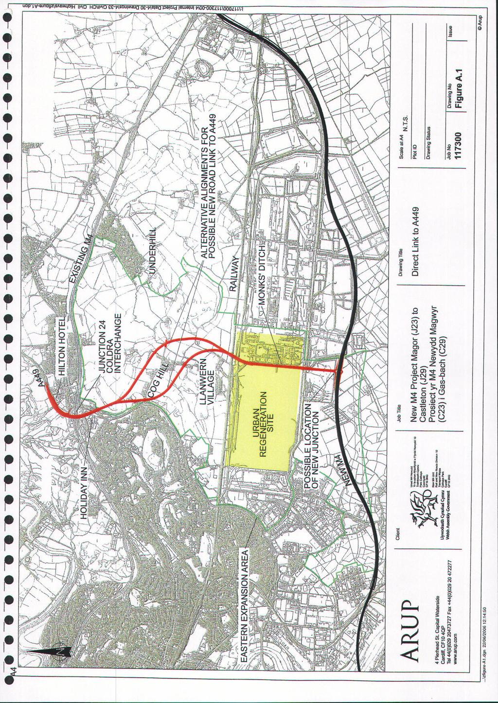
5 Transport Wales Welsh Assembly Government New M4 Project - Magor to Castleton 2 OPTIONS CONSIDERED 2.1 Intermediate Junction Options In order to conduct a broad review, the following intermediate junction options were initially considered in terms of alignment, physical constraints and design standards: A link directly to the A449 north of the existing M4 Junction 24, from a grade separated junction on the New M4 to the south of the Corus Steelworks as illustrated in Figure A.1 in Appendix A; The previously proposed eastern junction connecting to Nash Road and Meadows Road (see Figure A.2 in Appendix A); A modification of the previously proposed eastern junction without a through link along Nash Road (see Figure A.3 in Appendix A); A modification of the previously proposed eastern junction without a through link along Nash Road, but with a possible link to Corporation Road (see Figure A.4 in Appendix A); A link to the A48 west of Newport via an existing industrial estate road from a junction on the New M4 immediately to the east of the LG electronics factory (see Figure A.5 in Appendix A); and A link to the A48 via the Duffryn Link Road (see Figure A.6 in Appendix A). The characteristics of each of the above options are described below. 2.2 Direct Link To A449 This option commences with a grade-separated junction on the New M4 to the south of the Corus steelworks. This junction would be situated within the Gwent Levels Site of Special Scientific Interest (SSSI). The route runs at high level on the west side of Monks Ditch through Newport s Eastern Expansion Area and crosses the existing dual-carriageway steelworks access road. North of this road, the alignment then drops to ground level, before rising again to cross over the existing railway lines running along the northern boundary of the Works. Beyond the railway, there are two possible routes. The eastern route lies in open farmland and skirts the village of Llanwern. The western route swings to the west and crosses through the village and proposed development land, before turning north to cross over Cog Hill. North of Cog Hill, the routes follow the same line and enter an extended viaduct structure over the A48 Newport Southern Distributor Road (SDR), the western side of the M4 Junction 24 Coldra gyratory and the motorway. The route then turns to the north-east to link with the A449. Links between the A449 and the Coldra junction would be maintained by new south-facing slip roads. The purpose of the route would be to provide a direct link between the A449 and the New M4 south of Newport. This is a strategic route; as such, no connections are provided off it to the remainder of the highway network. It is envisaged that the following structures would be required: Bridges at junction with New M4; Retaining walls alongside Monks Ditch Bridge over Steelworks Access Road; Two bridges over railway lines; J:\117000\ \4 INT PROJ DATA\4-50 REPORTS\ JUNCTION STRATEGY REVIEW\0002 JUNCTION STRATEGY REVIEW FINAL.DOC 06/6866 Page 2 5 Final : April 2006
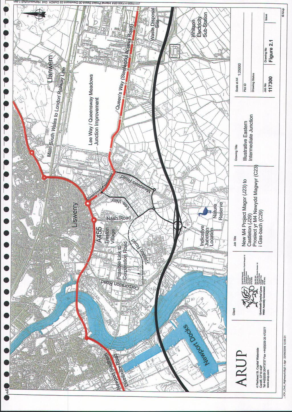
6 Transport Wales Welsh Assembly Government New M4 Project - Magor to Castleton West route Bridge over Station Road; West route Bridge over Cog Hill; East route Bridge over side road between Llanwern and Wilcrick; East route Access bridge over the A449; East route Bridge over Langstone Lane; Bridge/fly-over at Coldra. This would include support of the elevated A449 alongside the new slip roads with retaining walls; Retaining wall for the southbound-off slip road to provide minimum separation from the Hilton Hotel; Retaining wall for northbound-on slip road to support the golf course; and Culverts. In the south, the route runs alongside the Monks Ditch through an area, which is designated as an Urban Regeneration Site. It crosses the railway on elevated structure. The eastern option runs to the north and east of Llanwern village, to loop around it and continue to the south. In doing so, it crosses Langstone Lane and the access to Llanwern Park Farm, which will need to be retained either under or over the route. It has been assumed that the route will pass over Langstone Lane and the access road will be carried over. The western option runs to the west of and subsequently through, Llanwern village. It would be elevated to cross Cog Hill, and an access to property to the north would either need to be accommodated, or the property acquired. The elevated road would be visible not only to residents on Cog Hill, but also from properties on the eastern edge of the Ringlands estate. Further south, the road crosses open country before crossing over Station Road, Llanwern. Two properties would be directly affected by the road, and the bridge would cut through the village, though physical connections would be retained. In both cases, structures would be required which would be intrusive in this rural area. Both options would pass through Scotch Wood which is designated as environmental space. At the northern end, there is considerable encroachment into the grounds surrounding the Holiday Inn and Hilton Hotels. As a result traffic is brought much nearer to these hotels. The road is elevated across the Coldra junction and other highways, and would be visually intrusive. This option was discounted following initial traffic assessments, which indicated that there was very limited traffic demand to use the new link due to the circuitous routeing of what would be an expensive link road. 2.3 Eastern Junction Connecting into Nash Road and Meadows Road For this option, the motorway junction would be located approximately mid-way between the Uskmouth Power Station railway line and Nash Road, and would connect to both west and east. A new link would connect to Nash Road, and then continue through to a new junction on Meadows Road (see Figure 2.1 and Figure A.2). J:\117000\ \4 INT PROJ DATA\4-50 REPORTS\ JUNCTION STRATEGY REVIEW\0002 JUNCTION STRATEGY REVIEW FINAL.DOC 06/6866 Page 3 6 Final : April 2006
7 Transport Wales Welsh Assembly Government New M4 Project - Magor to Castleton A link would thus be provided from the New M4 junction to Nash Road and Meadows Road. The Nash Road junction would connect to the north along the existing road with a priority junction to the Queensway Meadows industrial estate at Lee Way. This option would provide a direct link to the south east side of Newport. The junction would connect directly to the industrial estates in this area, and also provide a link to the Southern Distributor Road (SDR). There would remain a need for Nash Road/Meadows Road to be connected across the proposed New M4 motorway to retain access to the Levels to the south, and vehicular access to the Uskmouth Power Station. Other than bridges over the motorway, it is likely that no structures other than culverts should be necessary for this option. Following initial traffic assessments, this option was discounted due to the effects on Nash Road as this would become the shortest route towards the city centre. This would result in a large increase in traffic through the village of Traston, and past a school and college. 2.4 Eastern Junction Connecting into Meadows Road Only For this option, the motorway junction would be located approximately mid-way between the Uskmouth Power Station railway line and Nash Road, and would connect to both west and east. A new link would connect to Nash Road, and then continue through to a new junction on Meadows Road (see Figures 2.1 and A.3). The initial traffic assessment of the junction option described in 2.3 indicated that, as Nash Road would be the most direct route to the city centre from the New M4, there would be a large increase in traffic volumes passing through a residential area and past a school and college. This would be an undesirable effect. This option, therefore, closes Nash Road to all through traffic with the exception of buses to the north of a priority junction to the Queensway Meadows Industrial Estate at Lee Way. For this option, initial traffic assessment shows limited route choice for New M4 traffic wishing to access destinations in Newport. This may result in some motorway traffic choosing to using Lee Way (ie rat-running through the Queensway Meadows Industrial Estate) to access the SDR via Queensway Meadows. This could also result in additional traffic turning movements at the Lee Way/Queensway Meadows/Retail Park junction which, due to planned development of the Eastern Expansion Area, may experience capacity problems post Eastern Junction Connecting into Meadows Road with a Possible Link to Corporation Road For this option, the motorway junction would be located approximately mid-way between the Uskmouth Power Station railway line and Nash Road, and would connect to both west and east. A new link would connect to Nash Road, and then continue through to a new junction on Meadows Road (see Figure 2.1 and Figure A.4). Nash Road would be closed to all vehicles except buses to the north of the new section of road to reduce the numbers of vehicles passing through the residential area and past the school and college. Following the suggestion by Newport City Council, a possible new link to Corporation Road has been considered. The new section of road would turn to the west to run along Traston Road to a proposed new junction on Corporation Road. It is proposed that this new section of road should be restricted to no more than 40mph to be in keeping with a road entering a lower speed area at Lee Way and Traston Road. J:\117000\ \4 INT PROJ DATA\4-50 REPORTS\ JUNCTION STRATEGY REVIEW\0002 JUNCTION STRATEGY REVIEW FINAL.DOC 06/6866 Page 4 7 Final : April 2006
8 Transport Wales Welsh Assembly Government New M4 Project - Magor to Castleton The connection to Corporation Road would be beneficial in directing drivers away from the Queensway Meadows area, but may place more emphasis on turning movements where the SDR and Corporation Road meet. However, there would need to be a series of priority junctions along the link to Corporation Road, to serve the existing commercial interests along the road, and to maintain existing highway links to the surrounding industrial areas. These should assist as speed restraints along the route. Small parcels of land along the line of Nash Road and Traston Road would need to be acquired, where minor realignments and widenings at junctions would extend the footprint of existing highways. An additional area to the west of Corporation Road might be required to allow the construction of a new junction. 2.6 Western Junction Connecting to A48 East of LG Factory This option lies on the west side of the Usk and would provide a connection between the New M4 motorway and an existing roundabout which is located to the south-east of the LG factory (see Figure A.5 in Appendix A). This roundabout would then connect to the existing A48 to the west of Cleppa Park via an existing single carriageway road, Celtic Way. For this option, the proposed junction with the New M4 would be located within the Gwent Levels SSSI. The connection with the New M4 is proposed to be via east facing slip roads; a connection to the west cannot be achieved as the proximity of the proposed junction to the Castleton interchange would result in unacceptably short weaving lengths (refer to TD22/06). The level of traffic usage is such that the proposed slip roads would be single carriageway links to a two-way single carriageway road up to the roundabout. The westbound-off slip road would pass through a small radius loop to cross under itself and pass beneath the motorway to the west of the proposed motorway bridge over the London South Wales main line railway. It would then run to the west of an existing electrical sub-station where it would merge into the two-way road. The eastbound on slip would leave the two-way road and climb on a horizontal curve, to merge with the eastbound lane of the new M4 on the proposed tunnel structure over the railway. It is proposed that the link roads should be speed limited to 40mph, to enable the footprint of the junction to be as small as possible and prevent unnecessarily large radii for curves. The structural content consists of a slight increase in length of the proposed bridge over the railway, and two bridges where the loop of the westbound-off slip road passes beneath itself and under the motorway. Additionally, the requirement for the slip road link to pass beneath the motorway will dictate that the motorway must remain at a higher level than originally proposed in this area, probably with a crest between the link road bridge and the railway, rather than cresting over the railway. The westbound off-slip road would impact significantly on existing farm buildings to the south of the LG factory. Properties along the Pont-yr-Estyll Lane would continue to be accessed via Percoed Lane, crossing the railway and connecting with Lighthouse Road. There is also a link to the Duffryn Link road. With the motorway in place, the existing connection through to Lighthouse Road would be replicated using an existing bridge over the railway and a new connection to Pont-yr-Estyll Lane. A new junction in this location would place the farm buildings within the junction loop, and any connection from the farm to existing highways and the surrounding land would be severed. J:\117000\ \4 INT PROJ DATA\4-50 REPORTS\ JUNCTION STRATEGY REVIEW\0002 JUNCTION STRATEGY REVIEW FINAL.DOC 06/6866 Page 5 8 Final : April 2006
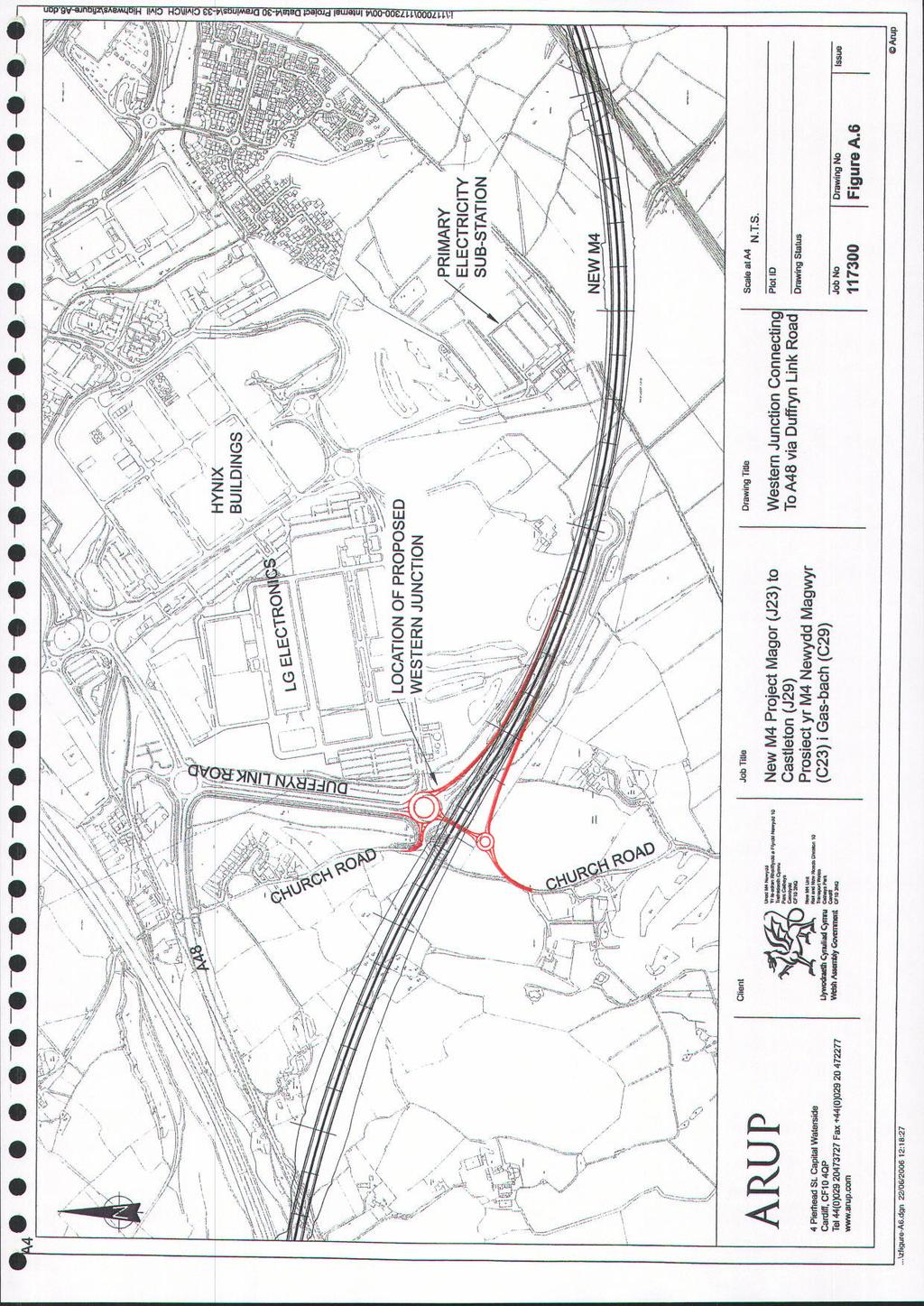
9 Transport Wales Welsh Assembly Government New M4 Project - Magor to Castleton This option was discounted following the initial traffic assessment, which indicated that there would be no advantages in network operational terms to this option when compared with the option described in 2.7, which would not involve development within the Gwent Levels SSSI. 2.7 Western Junction with Connection to the A48 via Duffryn Link Road This option comprises a western junction to link to an existing intermediate roundabout on the Duffryn Link Road (see Figures 1.2 and A.6). As a result of the proximity to the proposed junction at Castleton, it would not be possible to provide west-facing links, as the resulting weaving lengths would be well below acceptable standards for safe operation for the anticipated traffic flows. For this reason, the junction has been considered with east-facing slip roads only. The westbound off-slip road would leave the motorway in the area of the proposed bridge over the railway and drop to grade, where a new roundabout would connect to an existing roundabout on the Duffryn Link Road via a bridge under the motorway. To accommodate this, the proposed level of the motorway would need to be raised, which would reduce the quantity of material to be disposed of off-site in this area. A link would be provided to the existing highway system to the south of the New M4. As no link will be required to the factory to the east, the opportunity will be taken to reduce the size of the existing roundabout. The eastbound-on slip road would connect directly from the modified roundabout. The provision of a junction on the New M4 does not require any additional structures as a bridge would be required at this location on the New M4 to provide access to Church Road in any event. The proposed location of this junction option is outside the designated area of the Gwent Levels SSSI. J:\117000\ \4 INT PROJ DATA\4-50 REPORTS\ JUNCTION STRATEGY REVIEW\0002 JUNCTION STRATEGY REVIEW FINAL.DOC 06/6866 Page 6 9 Final : April 2006
10 Transport Wales Welsh Assembly Government New M4 Project - Magor to Castleton 3 TRAFFIC ASSESSMENT OF JUNCTION OPTIONS 3.1 Interim Traffic Model A traffic model is needed to provide traffic flow and toll revenue forecasts for the New M4. The New M4 Traffic Model will be used to support the planning process up to and including Public Inquiry. This model will be based on recent origin and destination data and development of the New M4 Base Year Model (2005) is on-going. In the meantime, an Interim Traffic Model has been developed by updating an existing 2002 SATURN traffic model of the Newport area to a 2005 base. In order to update the 2002 model, it was necessary to include the most recent available data on travel demand, which included the results of postcard surveys conducted at the Severn bridges in 2003 and junction turning count and link flow surveys carried out in the Newport area during In addition, a detailed inventory was conducted of the road network within the model simulation area in order to update the simulated network in the model. A new sub-model was also developed to forecast choice between tolled and free road links. This Toll Choice Model was based on Stated Preference surveys specifically designed for the New M4 Project and carried out in December The Interim Traffic Model with a Toll Choice Model incorporated has been used to carry out a series of initial assessments to examine the traffic impacts of the various intermediate junction options for the New M4. For the purposes of comparing the relative impacts of each of the options examined, a common future year situation has formed the basis for model runs. Traffic forecasts have been prepared for two future years 2013 and Future development proposals are assumed to be in line with the city s regeneration strategy, which includes the Eastern Expansion, the City Centre Master Plan and the Western Development Area. In order to represent the spectrum of options available for inclusion in a preferred junction strategy, the following junction scenarios were modelled with and without tolls on the New M4: No intermediate junctions; Eastern junction connecting into Meadows Road only; Eastern junction connecting into Meadows Road with a possible link to Corporation Road; and Eastern junction connecting into Meadows Road with a possible link to Corporation Road and western connection to A48 via Duffryn Link Road. In addition to the above scenarios, the provision of a new road link from the A449 to the New M4 was modelled and found to result in negligible impact and hence has not been considered further. Similarly the provision of solely a western junction has been modelled and been found to generate less use and hence lower impact than is the case for an eastern junction. Consequently, if only one intermediate junction were to be provided, on traffic grounds this would best be located on the east bank of the River Usk and outside of the Gwent Levels SSSI. The broad outcomes of the assessments are summarised below and the resulting forecast Annual Average Daily Traffic (AADT) in vehicles per day using the existing M4, the SDR and the proposed New M4 and Steelworks Access Road in 2013 are illustrated on Figures 3.1 to 3.4. These assessments assume that the Steelworks Access Road will be up-graded and be in use as public highway. However, any development of the Steelworks Access Road is outside of the Assembly s control. J:\117000\ \4 INT PROJ DATA\4-50 REPORTS\ JUNCTION STRATEGY REVIEW\0002 JUNCTION STRATEGY REVIEW FINAL.DOC 06/6866 Page 7 10 Final : April 2006
11 Transport Wales Welsh Assembly Government New M4 Project - Magor to Castleton It should be noted that the traffic assessments reported at this stage are based on the provision of the New M4 with no tolls applied. Further work is to be carried out to investigate the likely impact of tolling the New M No Intermediate Junctions The traffic forecasts indicate that the provision of the New M4 would have a significant impact on the existing M4 motorway and the road network in Newport (see Figure 3.1). The main effects in comparison to a do-minimum scenario (i.e. without the New M4) are: Traffic flows on the existing M4 would decrease dramatically with the New M4 in place. The expected order of decrease would be 37% to 51% of annual average daily traffic (AADT), with a decrease of up to 51% in AADT through the Brynglas tunnels; Traffic flows on the sections of the existing M4 to the east and to the west of the Brynglas Tunnels would be higher than those on the New M4 (approximately 33% and 45% respectively higher than New M4 flows). However, the traffic flows through the tunnels themselves would be 16% lower than those on the New M4; and There would be a reduction in flows on the SDR to the south of Newport, equating to a decrease of 7% in AADT flow across the Usk bridge. 3.3 Eastern Junction Connecting into Meadows Road Only The implementation of the New M4 with no intermediate junctions would create a new strategic route around Newport with significant traffic flows in all time periods. However, use of the New M4 is increased by the introduction of an intermediate junction which increases the volume of traffic on the New M4, further decreases traffic on the existing M4 and SDR and introduces route choice for to a range of locations within Newport. This eastern junction option comprises an all movements junction on the New M4 on the eastern side of the River Usk with a link to Meadows Road. Nash Road would be altered to ban the through route to the SDR for all vehicles except buses at a point just north of Lee Way. Traffic assignments using the Interim Traffic Model indicate the following differences compared with the situation with no intermediate junction: Higher traffic flows on the New M4, 6% increase in AADT on the eastern section, 8% on the western section; Use of the intermediate junction by 7600 vehicles AADT; A slight change in the relief to the existing M4 (< 5%); SDR flows at the River Usk bridge decrease by 8% of AADT in comparison to no intermediate junction; and It has been assumed that the signalised junction of Queensway Meadows/Lee Way/ Newport Retail Park (see Figure 2.1) will be improved in accordance with Newport s Eastern Expansion Area proposals. In the 2013 forecast scenario, the Interim Traffic Model indicates that the junction will operate satisfactorily. However, by 2028, delays are forecast to be high due to increased flows arising as a result of local development and increased traffic flows from the New M4. This would be likely to require further junction improvements and/or re-routeing. J:\117000\ \4 INT PROJ DATA\4-50 REPORTS\ JUNCTION STRATEGY REVIEW\0002 JUNCTION STRATEGY REVIEW FINAL.DOC 06/6866 Page 8 11 Final : April 2006
12 Transport Wales Welsh Assembly Government New M4 Project - Magor to Castleton 3.4 Eastern Junction Connecting into Meadows Road with a Possible Link to Corporation Road It is possible to increase further the use of an eastern junction by introducing additional connections and hence increasing route choice for traffic between the New M4 and Newport (see Figure A.4 in Appendix A and Figure 2.1). In early stages of the junction strategy work (as in previous studies), this was achieved by providing a through connection to the SDR via Nash Road (see Figure A.2 in Appendix A). However, the resulting traffic assignments indicated that such a configuration would lead to high volumes of traffic using Nash Road as a through route. This would be an undesirable impact, due to the adjacent residential and educational land uses. As part of City Centre Master Plan, it is proposed to revise the configuration of the Cenotaph junction at the northern end of Corporation road to create an all movement junction. This will improve access to Corporation Road. Comparing this option containing a link to Corporation Road with the option described in 3.3, the following changes in traffic flow patterns have been forecast: An increase in traffic using the eastern junction, increased to 12,150 AADT, which represents a 60% increase. The majority of this increase would arise from traffic using the additional link to Corporation Road; An increase in traffic volumes on the New M4, which is most pronounced on the eastern section where AADT volumes increase by 7%; Traffic volumes on the existing M4 remain largely unchanged, except on the section between junctions 23 and 24 where there are further modest reductions of 4-6%; and Traffic travelling to the industrial area (at the southern end of Corporation Road) from the New M4 would be likely to access this area directly via the new link. 3.5 Eastern Junction Connecting into Meadows Road with a Possible Link to Corporation Road and Western Connection to A48 via Duffryn Link Road This option includes a western junction with east facing slip roads to provide access to/from the east to the western-most sector of the city. In addition to other development proposals, it is understood that consideration is currently being given to the possible development of a new conference and/or exhibition centre at the Hynix site in this area. The traffic model does not currently take into account the possible traffic generation of such a facility at this location, which at certain times would be likely to be significant. Nevertheless, traffic model tests indicate that even without this traffic there would be demand for a western junction serving the western development areas and linking to the A48. In addition to the impacts described for an eastern junction, the testing of a western connection has indicated that: The western connection would be used by around 2.6m vehicles a year, although this demand is not as great as for an eastern connection, it indicates a significant level of use that would increase with the possible development of a conference and/or exhibition centre; The AADT on the New M4 at the river crossing is forecast to be in the region of 62,000 vehicles; The presence of a western junction further increases use of an eastern junction by 13% indicating some use of the New M4 by local traffic; J:\117000\ \4 INT PROJ DATA\4-50 REPORTS\ JUNCTION STRATEGY REVIEW\0002 JUNCTION STRATEGY REVIEW FINAL.DOC 06/6866 Page 9 12 Final : April 2006
13 Transport Wales Welsh Assembly Government New M4 Project - Magor to Castleton There is a further decrease of traffic volumes forecast on the existing M4 of up to 6% in AADT between junctions 25a and 26 (Brynglas Tunnels); and Traffic on the A48 through Castleton increases approaching the route to the western junction. 3.6 Comments on Traffic Assessments From the traffic assessments undertaken to date, there would be benefits occurring from the provision of an intermediate junction, in terms of increased use of the New M4 with consequent relief to other routes. The assessments show that the provision of an eastern junction increases use of the New M4 compared with no intermediate junction and that a possible link to Corporation Road would increase route choice as well as providing direct access to industrial areas. The Interim Traffic Model indicates that this option would be likely to provide relief to the Queensway Meadows/SDR route into the city. Provision of a western connection via the Duffryn Link Road would serve the Western Development Area and would appear to have traffic benefits. However, such benefits are likely to be more localised than those arising as a result of the provision of an eastern junction. Nevertheless, the benefits that are likely to occur in each case are cumulative, so that the provision of both an eastern junction and the proposed partial western junction would result in maximum benefit with due regard to road safety. 3.7 Initial Assessment of the Impact of Tolling the New M4 The New M4 will offer an alternative to the existing M4 for through trips and, via intermediate junctions, will provide access routes to parts of south and central Newport. The New M4 will offer shorter journey times than the existing M4, but a toll will be charged. This will result in a trade-off between journey time saving and toll payment. This is termed willingness to pay and is influenced by the value of time. There will be a distribution in value of time across the population. Those with high values of time are more likely to choose the toll road than those with low values. The New M4 will offer an alternative to the existing M4 route in respect of the following attributes: journey distance; mean journey time; variance of journey time ( reliability ); road standard horizontal and vertical alignment, tunnels and bridges, number of lanes, carriageway width, junction spacing; road safety (actual and perceived) and driver stress related to road standard and characteristics of traffic flow (eg entering, exiting and weaving); operating cost; and toll. Stated Preference (SP) surveys, which are an universally recognised method of assessing willingness to pay, have been conducted locally. J:\117000\ \4 INT PROJ DATA\4-50 REPORTS\ JUNCTION STRATEGY REVIEW\0002 JUNCTION STRATEGY REVIEW FINAL.DOC 06/6866 Page Final : April 2006
14 Transport Wales Welsh Assembly Government New M4 Project - Magor to Castleton The SP surveys focused on the key trade-off between journey time saving and toll, and a representation of the quality differential between the New M4 and the existing route as reflected in the attributes referred to above. A number of SP experiments were designed to offer choice of route between the existing free M4 and the new tolled M4, with separate designs developed for business and non-business car travel and HGV journeys to take account of expected differences in willingness to pay of the differing groups of travellers. During the SP surveys, no reference was made to the possible implementation of restraint measures on the existing M4. Previous research (including for the M6 Toll) has suggested that the time spent in free-flow conditions is preferred to time spent in congested conditions. For this reason, the free-flow and congested (queue) times were identified as separate components for a range of scenarios where car and heavy goods vehicle (HGV) drivers were invited to choose between use of the tolled and free routes during the SP surveys. The locally conducted market research (SP) has involved the interviewing of in excess of 1000 car and HGV drivers. Initial analysis of survey responses and comparison with other evidence, including behaviour at the M6 Toll, has suggested that the impact of the introduction of even a modest toll will result in vehicles that would otherwise use the New M4 choosing not to do so. Preliminary assessment suggests that the proportion choosing to use the toll road would not be unduly influenced by junction locations. In this case, the provision of intermediate junctions would increase use of the New M4 and hence toll revenue compared with no intermediate junction. Preliminary assessment of a tolled New M4 also indicates that toll revenues would be likely to be higher with both an eastern junction and a western partial junction. J:\117000\ \4 INT PROJ DATA\4-50 REPORTS\ JUNCTION STRATEGY REVIEW\0002 JUNCTION STRATEGY REVIEW FINAL.DOC 06/6866 Page Final : April 2006
15 Transport Wales Welsh Assembly Government New M4 Project - Magor to Castleton 4 ECONOMIC EVAULATION 4.1 Basis of Transport User Benefit Appraisal (TUBA) Following traffic assessment using the Interim Traffic Model, a broad economic evaluation of the various scenarios has been undertaken using the Transport User Benefit Appraisal (TUBA) software. TUBA was developed for the Department for Transport (DfT) to undertake economic appraisal for multi-modal transport studies. The program uses as input fixed or variable trip matrices, times, distances and applicable charges output from a transport model. The input trip information may also be split further into different user classes in terms of trip purpose and vehicle type. Costs associated with a base situation without the New M4 (do-minimum) and the option under appraisal are also an input requirement to the process. Using these inputs, the TUBA software calculates user benefits and costs, both of which are split into several subcategories and discounted to a chosen base year. Under current practice, the base year for discounting, to which all costs and benefits should be discounted, is the DfT s standard base year, which is currently The calculated values are interpolated and then extrapolated to output results covering a 60 year forecast period. 4.2 Assumptions Used in TUBA Evaluation As this current exercise is intended to be an initial broad economic evaluation for comparison of options, costs for the following have not been included: Accidents; Maintenance; and Delays as a result of maintenance. Construction costs, for each option, as quoted in section 2, were used in order to evaluate each of the junction scenarios assessed as described in section Output of TUBA The output from the TUBA is summarised below: Option Eastern Junction Connecting into Meadows Road with a Possible Link to Corporation Road and Western Connection to A48 via Duffryn Link Road Eastern Junction Connecting into Meadows Road with a Possible Link to Corporation Road Present Value of Benefits PVB ( x 1000) Present Value of Costs PVC ( x 1000) Net Present Value NPV ( x 1000) Benefit to Cost Ratio BCR 3,870, ,856 3,374, ,668, ,843 3,177, No intermediate junctions 3,324, ,055 2,856, Eastern Junction Connecting into Meadows Road Only 3,202, ,536 2,732, J:\117000\ \4 INT PROJ DATA\4-50 REPORTS\ JUNCTION STRATEGY REVIEW\0002 JUNCTION STRATEGY REVIEW FINAL.DOC 06/6866 Page Final : April 2006
16 Transport Wales Welsh Assembly Government New M4 Project - Magor to Castleton The eastern junction together with a western connection to the Duffryn Link Road and hence the A48 provides a high benefit to cost ratio (BCR). If account were to be taken of additional traffic that might result from development of the Hynix site, it is likely that the BCR would increase further. The network benefits of an eastern junction connecting into Meadows Road only are lower than other options due to less route choice between the New M4 and destinations within Newport. J:\117000\ \4 INT PROJ DATA\4-50 REPORTS\ JUNCTION STRATEGY REVIEW\0002 JUNCTION STRATEGY REVIEW FINAL.DOC 06/6866 Page Final : April 2006
17 Transport Wales Welsh Assembly Government New M4 Project - Magor to Castleton 5 JUNCTION STRATEGY: OVERALL SUMMARY The New M4 motorway between Magor and Castleton will provide an attractive route for through traffic and for east/west traffic with a destination in Newport. This will result in considerable relief to traffic flows on the existing M4 around Newport. The New M4 will offer shorter journey times than the existing M4 for vehicles travelling east/west and the Welsh Assembly Government currently proposes that a toll will be charged for use of the New M4. This will result in a trade-off between journey time saving and toll payment. In a tolled situation for the New M4, preliminary assessment has indicated that the location of junctions on the New M4 will be unlikely to influence the proportion of vehicles choosing to use the toll road. At the eastern end, Junction 23A will provide connections to the M4, the M48, the local road network and the Motorway Service Area at Magor. At Junction 29 at the western end, connections will be provided to the M4 to the north of Cardiff and to the A48(M) into Cardiff. The inclusion of an intermediate junction on the New M4 facilitating access to Newport s road network will provide greater route choice for drivers wishing to reach locations within the city, especially in the south of the city. Previous studies had shown that a junction east of the River Usk would provide a good connection to the city s road network via Meadows Road and the Southern Distributor Road. The opportunity also exists to provide a further connection to link into Corporation Road, which will increase route choice between destinations in the city and the New M4 motorway. Whilst the provision of one or more intermediate junctions on the New M4 will be likely to result in improved access to destinations in Newport from the strategic road network, there remain sources of congestion and delay, especially at Junction 28 Tredegar Park and Junction 24 The Coldra. The provision of intermediate junctions on the New M4 will not be likely to obviate the need for improvement to traffic conditions at Junction 24 and Junction 28. In the western areas of the city, sites have been allocated for future development and, bearing in mind the situation at Junction 28 in particular, the provision of a western partial junction with east-facing slip-roads will accommodate direct access to the western sector of the city from the east. J:\117000\ \4 INT PROJ DATA\4-50 REPORTS\ JUNCTION STRATEGY REVIEW\0002 JUNCTION STRATEGY REVIEW FINAL.DOC 06/6866 Page Final : April 2006
18 18 FIGURES
19 19
20 20
21 21
22 22
23 23
24 24
25 25
26 APPENDIX A Figure A.1 Figure A.2 Figure A.3 Figure A.4 Figure A.5 Figure A.6 Direct Link to A449 Eastern Junction Connecting into Nash Road and Meadows Road Eastern Junction Connecting into Meadows Road Only Eastern Junction Connecting into Meadows Road with a Possible Link to Corporation Road Western Junction Connecting to A48 East of LG Factory Western Junction Connecting to A48 via Duffryn Link Road 26
27 27
28 28
29 29
30 30
31 31
32 32
Summary Proof of Evidence Traffic
 Adran yr Economi a r Seilwaith Department for Economy and Infrastructure The M4 Motorway (Junction 23 (East of Magor) to West of Junction 29 (Castleton) and Connecting Roads) and The M48 Motorway (Junction
Major Scheme Business Case Summary Report for Programme Entry
 Paper A Heart of South West Local Transport Board Major Scheme Business Case Summary Report for Programme Entry M5 Junction 25, Taunton July 2016 1 SCHEME SUMMARY Scheme Name M5 Junction 25, Taunton Date
Sky Temporary Car Park Transport Statement
 001 Issue 26 August 2016 This report takes into account the particular instructions and requirements of our client. It is not intended for and should not be relied upon by any third party and no responsibility
EXPLANATORY STATEMENT
 THE LONDON TO FISHGUARD TRUNK ROAD (A40) (PENBLEWIN TO SLEBECH PARK IMPROVEMENT) ORDER 200- AND THE LONDON TO FISHGUARD TRUNK ROAD (A40) (PENBLEWIN TO SLEBECH PARK IMPROVEMENT SIDE ROADS) ORDER 200-1.
THE WELSH MINISTERS STATEMENT OF REASONS
 THE WELSH MINISTERS The Welsh Ministers (The M4 Motorway (Junction 23 (East of Magor) to West of Junction 29 (Castleton) and Connecting Roads) and The M48 Motorway (Junction 23 (East of Magor) Connecting
London Borough of Barnet Traffic & Development Design Team
 London Borough of Barnet Traffic & Development Design Team AERODROME ROAD PEDESTRIAN FACILITY AND BUS STOP INTRODUCTION FEASIBILITY REPORT Job Number: 60668 Doc Ref: S106/12-13/60668 Author: Manoj Kalair
PUBLIC INQUIRY QUESTION
 REFERENCE NO. : PIQ / 019 PUBLIC INQUIRY QUESTION RAISED BY: The Inspectors DATE: 20/02/17 RESPONDED BY: Ben Sibert DATE: 10/03/17 SUBJECT: Engineering Proof of Evidence Elucidations The attached document
Scheme Evidence Update Planning & Sustainable Development. Adran yr Economi a r Seilwaith Department for Economy and Infrastructure
 Adran yr Economi a r Seilwaith Department for Economy and Infrastructure This document is an update to the Proof of Evidence Planning & Sustainable document. It contains an update following the addition
Welsh Government M4 Corridor around Newport - Motorway to the South of Newport Local Model Validation Report
 M4 Corridor around Newport - Motorway to the South of Newport 14-9235 Issue July 2014 This report takes into account the particular instructions and requirements of our client. It is not intended for and
ENVIRONMENTAL SCRUTINY COMMITTEE 6 DECEMBER 2016
 CITY & COUNTY OF CARDIFF DINAS A SIR CAERDYDD ENVIRONMENTAL SCRUTINY COMMITTEE 6 DECEMBER 2016 EASTERN BAY LINK JOINT STUDY PROPOSAL Reason for the Report 1. To provide Members with the opportunity to
SUMMARY PROOF OF EVIDENCE. Gerald Kells Transport Policy and Campaigns Advisor
 Highways Inquiry Procedure Rules 1994 Doc Ref: OBJ/0125 2 For a local inquiry into: SUMMARY PROOF OF EVIDENCE Gerald Kells Transport Policy and Campaigns Advisor For Friends of the Earth Cymru / Cyfeillion
Capital & Counties. October 2007
 Capital & Counties October 2007 Contents!" # $ % % $ & ' "&( # Appendix 1 Appendix 2 1 Introduction 1.1.1 Wincheap regeneration scheme proposes a 600 space Park and Ride facility to replace the existing
201- No. (W. ) HIGHWAYS, WALES
 HIGHWAYS, WALES") W E L S H S T A T U T O R Y I N S T R U M E N T S 201- No. (W. ) HIGHWAYS, WALES The M4 Motorway (Junction 23 (East of Magor) to West of Junction 29 (Castleton) and Connecting Roads) and The M48 Motorway
W E L S H S T A T U T O R Y I N S T R U M E N T S 201- No. (W. ) HIGHWAYS, WALES The M4 Motorway (Junction 23 (East of Magor) to West of Junction 29 (Castleton) and Connecting Roads) and The M48 Motorway
A. CONCLUSIONS OF THE FGEIS
 Chapter 11: Traffic and Parking A. CONCLUSIONS OF THE FGEIS The FGEIS found that the Approved Plan will generate a substantial volume of vehicular and pedestrian activity, including an estimated 1,300
Saighton Camp, Chester. Technical Note: Impact of Boughton Heath S278 Works upon the operation of the Local Highway Network
 Technical Note: Impact of Boughton Heath S278 Works July 2013 SAIGHTON CAMP CHESTER COMMERCIAL ESTATES GROUP TECHNICAL NOTE: IMPACT OF BOUGHTON HEATH S278 WORKS UPON THE OPERATION OF THE LOCAL HIGHWAY
M2 Junction 5. improvements scheme. Preferred route announcement
 M2 Junction 5 improvements scheme Preferred route announcement May 2018 Investing in your roads Why is the scheme needed? At Highways England we believe in a connected country and our network makes these
M621. Junctions 1 to 7 Improvement scheme. Share your views
 M621 Junctions 1 to 7 Improvement scheme Share your views Investing in your roads Every road user wants less congested roads to enable swift, safe, comfortable and informed travel. On behalf of the government,
CHRISTCHURCH MOTORWAYS. Project Summary Statement February 2010
 CHRISTCHURCH MOTORWAYS Project Summary Statement February 2010 Table of Contents 1. Purpose of Document 2. Strategic Context 3. Benefits 4. Project Scope and Economics 5. Implementation Plan 1 ROADS OF
Response to the London Heathrow Airport Expansion Public Consultation
 Response to the London Heathrow Airport Expansion Public Consultation Summary This report sets out the response to the Heathrow Airport s consultation on airport expansion and airspace change. The consultation
Section 106 Update Memo #1 Attachment D. Traffic Diversion & APE Expansion Methodology & Maps
 Section 106 Update Memo #1 Attachment D Traffic Diversion & APE Expansion Methodology & Maps I-65/I-70 North Split Interchange Reconstruction Project (Des. Nos. 1592385 & 1600808) Traffic Diversion and
Report to: Greater Cambridge Partnership Joint Assembly 18 January A10 Foxton level crossing bypass and travel hub
 Report to: Greater Cambridge Partnership Joint Assembly 18 January 2018 Lead officer: Chris Tunstall GCP Director of Transport A10 Foxton level crossing bypass and travel hub 1. Purpose 1.1 The list of
M54 to M6/M6 Toll Link Road Public consultation
 to M6/M6 Toll Link Road Public consultation 15 September 2017 to 13 October 2017 Contents Introduction 4 5 Why do we need this scheme? 6 Previous consultation 7 8 Modified options 9 Option B West 10 Option
07/08 08/09 09/10 Total Carisbrooke Rest of Newport
 1 2 3 kjh 4 Forecasting The base year models have been developed to assist in forecasting the likely impacts of a number of development proposals in the Newport area and to inform the suitability of the
Lower Thames Crossing
 Lower Thames Crossing Post-Consultation Scheme Assessment Report Volume 7 Volume 7: Appraisal Summary and Recommendations Lower Thames Crossing 2017 - APPRAISAL SUMMARY AND RECOMMENDATIONS Contents Section
Sunshine Coast Airport Master Plan September 2007
 Sunshine Coast Airport Master Plan September 2007 Contents CONTENTS... I ACKNOWLEDGEMENT... II DISCLAIMER... III 1 EXECUTIVE SUMMARY...IV 1 INTRODUCTION... 1 2 AVIATION DEMAND FORECAST... 5 3 AIRCRAFT
Hearing Statement. M4 Corridor Around Newport Public Inquiry. St Modwen Developments Ltd
 St Modwen Developments Ltd February 2017 Hearing Statement Prepared on behalf for: St Modwen Developments Ltd by: Tim Gent BA (Hons) BPl MRTPI Savills 12 Windsor Place Cardiff CF10 3BY savills.co.uk PREFACE
an engineering, safety, environmental, traffic and economic assessment of each option to inform a preferred route option choice; 3) Development and as
 Development and as") Page: 42 Infrastructure Services REPORT TO ABERDEENSHIRE COUNCIL COMMITTEE 26 APRIL 2018 A96 ABERDEEN TO INVERNESS DUALLING POSITION STATEMENT 1 Recommendations Aberdeenshire Council is recommended to:
Page: 42 Infrastructure Services REPORT TO ABERDEENSHIRE COUNCIL COMMITTEE 26 APRIL 2018 A96 ABERDEEN TO INVERNESS DUALLING POSITION STATEMENT 1 Recommendations Aberdeenshire Council is recommended to:
Proposed M9 Spur Extension. Kirkliston
 Forth Road Bridge N Queensferry Proposed Scotstoun Interchange Proposed Humbie Flyover Proposed M9 Spur Extension M9 Motorway Kirkliston A720 Edinburgh City Bypass M8 Motorway This drawing has been reproduced
A303. Sparkford to Ilchester Dualling Scheme Preferred Route Announcement
 A303 Sparkford to Ilchester Dualling Scheme Preferred Route Announcement About this booklet This booklet presents the preferred route for the A303 Sparkford to Ilchester dualling scheme and a summary of
12, 14 and 16 York Street - Amendments to Section 16 Agreement and Road Closure Authorization
 REPORT FOR ACTION 12, 14 and 16 York Street - Amendments to Section 16 Agreement and Road Closure Authorization Date: April 27, 2018 To: Toronto and East York Community Council From: Senior Strategic Director,
Guildford Borough Transport Strategy 2017, Topic Paper: Transport, June 2017 (accompanying Local Plan 2017) Local Plan Transport Strategy 2017
 Local Plan Transport Strategy 2017") Guildford Society Transport Group Position Paper August 2017 Based on submissions in response to the June/July 2017 Local Plan consultation including material presented to Drop-in Session 15 July 2017.
Guildford Society Transport Group Position Paper August 2017 Based on submissions in response to the June/July 2017 Local Plan consultation including material presented to Drop-in Session 15 July 2017.
Launceston City Council. Kings Meadows Traffic Management Report for Public Consultation
 Launceston City Council Kings Meadows Traffic Management Report for Public Consultation November 2013 This report: has been prepared by GHD for Launceston City Council and may only be used and relied on
To: From: Plans showing the alignments of the routes discussed in this section are presented in Appendix A.
 Project: Cambourne to Cambridge Better Bus Journeys To: CCC Subject: Considerations for Corridor Option Plans From: Atkins Date: 1 Sep 2016 cc: 1. Introduction This note summarises considerations undertaken
HOW TO IMPROVE HIGH-FREQUENCY BUS SERVICE RELIABILITY THROUGH SCHEDULING
 HOW TO IMPROVE HIGH-FREQUENCY BUS SERVICE RELIABILITY THROUGH SCHEDULING Ms. Grace Fattouche Abstract This paper outlines a scheduling process for improving high-frequency bus service reliability based
201- No HIGHWAYS, WALES THE HIGHWAYS ACT 1980
 HIGHWAYS, WALES 201- No THE HIGHWAYS ACT 1980 THE M4 MOTORWAY (JUNCTION 23 (EAST OF MAGOR) TO WEST OF JUNCTION 29 (CASTLETON) AND CONNECTING ROADS) AND THE M48 MOTORWAY (JUNCTION 23 (EAST OF MAGOR) CONNECTING
As part of our transport vision, Leeds City Council, working with the West Yorkshire Combined Authority and Leeds Bradford Airport Company, is
 As part of our transport vision, Leeds City Council, working with the West Yorkshire Combined Authority and Leeds Bradford Airport Company, is considering options for improving surface access and connectivity
A303. Sparkford to Ilchester Dualling Scheme. Public consultation. Welcome. Highways England -- creative MCR18_0016
 Sparkford to Ilchester Dualling Scheme Public consultation Welcome Background The /A358 corridor provides vital east-west connectivity between the south west and London and the south east for people, communities
1. Summary of key points 2
 Petitions Committee NEVAR petition: Cardiff Airport access road This brief sets out the history and policy background to the development of proposals for improved surface access to Cardiff Airport (CA).
5.7 Local road upgrades
 5.7 Local road upgrades Local roads around the St Peters interchange and the intersection of Campbell Road and Euston Road would be upgraded to ensure safe and efficient connections with the New M5, and
Interstate 90 and Mercer Island Mobility Study APRIL Commissioned by. Prepared by
 Interstate 90 and Mercer Island Mobility Study APRIL 2017 Commissioned by Prepared by Interstate 90 and Mercer Island Mobility Study Commissioned by: Sound Transit Prepared by: April 2017 Contents Section
Regulatory Committee
 Page 1 - Proposed Turning Movement Bans at South Gate Junction, Dorchester Regulatory Committee Date of Meeting 16 March 2017 Officer Subject of Report Executive Summary Andrew Martin Service Director
Traffic calming on major roads: a traffic calming scheme at Costessey, Norfolk
 Traffic Advisory Leaflet 14/99 December 1999 Traffic calming on major roads: a traffic calming scheme at Costessey, Norfolk Introduction This leaflet summarises the impact of a traffic calming scheme on
Non-technical summary
 Introduction NTS1 NTS2 NTS3 Troika Developments Ltd (Troika) has submitted a planning application to Bournemouth Borough Council (BBC) for an extension of time to implement planning permission 7/2004/16450/G,
BARNSLEY METROPOLITAN BOROUGH COUNCIL
 BARNSLEY METROPOLITAN BOROUGH COUNCIL This matter is a Key Decision within the Council s definition and has been included in the relevant Forward Plan REPORT OF THE EXECUTIVE DIRECTOR OF PLACE TO CABINET
TERMINAL DEVELOPMENT PLAN
 5.0 TERMINAL DEVELOPMENT PLAN 5.0 TERMINAL DEVELOPMENT PLAN Key points The development plan in the Master Plan includes the expansion of terminal infrastructure, creating integrated terminals for international,
Yonge Street / Highway 401 Improvements Update. Public Works and Infrastructure Committee. General Manager, Transportation Services
 PW9.7 STAFF REPORT ACTION REQUIRED Yonge Street / Highway 401 Improvements Update Date: October 26, 2015 To: From: Wards: Reference Number: Public Works and Infrastructure Committee General Manager, Transportation
Commissioning Director - Environment
 Finchley and Golders Green Area Committee 27 April 2017 Title Report of Wards Status Urgent Key Enclosures Summers Lane,N12 Request for Pedestrian Improvements Commissioning Director - Environment Woodhouse
A140 study and Major Road Network
 A140 study and Major Road Network Executive Summary The Government s new Transport Investment Strategy sets out a new long-term approach for government infrastructure spending. Funding will be targeted
Traffic Calming and Road Safety Provision Options Woore Village
 Traffic Calming and Road Safety Provision Options Woore Village Contents 1 Executive Summary 4 2 Introduction 6 2.1 Background 6 3 Existing Provisions and Conditions 7 3.1 Background supporting option
20mph Speed Limit Zones
 Traffic Advisory Leaflet 7/91 May 1991 20mph Speed Limit Zones Summary This leaflet illustrates the main steps in the procedures for the implementation of 20mph zones. It provides brief details on: the
Economic Development Sub- Committee
 Report title: Economic Development Sub- Committee Item No. Date of meeting: 24 November 2016 A47 Road Investment Strategy - update Responsible Chief Tom McCabe Executive Director, Community Officer: and
THIRTEENTH AIR NAVIGATION CONFERENCE
 International Civil Aviation Organization AN-Conf/13-WP/22 14/6/18 WORKING PAPER THIRTEENTH AIR NAVIGATION CONFERENCE Agenda Item 1: Air navigation global strategy 1.4: Air navigation business cases Montréal,
Gold Coast. Rapid Transit. Chapter content. Chapter four Route selection and staging
 Chapter four Route selection and staging Gold Coast Rapid Transit Chapter four Route selection and staging Chapter content Route selection...73 Section one: Helensvale to Griffith University...74 Section
John Betts School Crossing Review
 John Betts School Crossing Review Paddenswick Road London Borough of Hammersmith & Fulham August 2015 DOCUMENT CONTROL Project Centre has prepared this report in accordance with the instructions from the
East West Rail Consortium
 East West Rail Consortium EWR Wider Economic Case: Refresh 18 th November 2015 Rupert Dyer Rail Expertise Ltd Rail Expertise Ltd. Tel: 01543 493533 Email: info@railexpertise.co.uk 1 Introduction 1.1 The
Busway between West Cambourne site and the junction of the A1303 / A428
 Project: A428 To: CCC Subject: Routes From: Atkins Date: 14 April 2016 cc: This note summarises the policy references to a bus link between Cambourne and Cambridge, in particular references to the route
Transport Business Case Report Maidstone Integrated Transport Package
 Transport Business Case Report Maidstone Integrated Transport Package CO04300369/013 Revision 01 January 2016 Document Control Sheet Project Name: Maidstone Integrated Transport Package Project Number:
Re-opening of the Skipton to Colne Railway Executive Summary
 Re-opening of the to Colne Railway Executive Summary SELRAP SELRAP is the East Lancashire Rail Action Partnership. It was established with the objective of campaigning for the reinstatement of the railway
Treasure Island Supplemental Information Report Addendum
 1 1 1 1 0 1 0 1 0 1 Treasure Island Supplemental Information Report Addendum Introduction Purpose The purpose of this Supplemental Information Report (SIR) Addendum is to determine if the current land
Agenda Item 5: Rail East Midlands Rail Franchise Consultation
 Strategic Transport Forum 15 th September 2017 Agenda Item 5: Rail East Midlands Rail Franchise Consultation Recommendation: It is recommended that the Forum agree (subject to any amendments agreed by
According to FAA Advisory Circular 150/5060-5, Airport Capacity and Delay, the elements that affect airfield capacity include:
 4.1 INTRODUCTION The previous chapters have described the existing facilities and provided planning guidelines as well as a forecast of demand for aviation activity at North Perry Airport. The demand/capacity
Arlington County Board Meeting Project Briefing. October 20, 2015
 Arlington County Board Meeting Project Briefing October 20, 2015 Project Map 2 Project Context Only Interstate in the Country limited to HOV only traffic during rush hours Stoplight at the end of I-66
Memorandum. Fund Allocation Fund Programming Policy/Legislation Plan/Study Capital Project Oversight/Delivery Budget/Finance Contract/Agreement Other:
 Memorandum Date: March 23, 2018 To: Transportation Authority Board From: Eric Cordoba Deputy Director Capital Projects Subject: 4/10/18 Board Meeting: San Francisco Freeway Corridor Management Study Update
MEMORANDUM. Open Section Background. I-66 Open Section Study Area. VDOT Northern Virginia District. I-66 Project Team. Date: November 5, 2015
 MEMORANDUM To: VDOT Northern Virginia District From: I-66 Project Team Date: November 5, 2015 Subject: Open Section Background The purpose of this technical memorandum is to provide narrative and technical
Watts St westbound thru
 Executive Summary At the request of the Hudson Square Business Improvement District, Sam Schwartz Engineering, DPC (Sam Schwartz) has completed a technical analysis of various congestion pricing and/or
5.1 Traffic and Transportation
 5.1 When it opens in 2009, the Bellevue Nickel Improvement Project will increase the number of vehicles able to travel through the study area, improve travel speeds, and improve safety by reducing the
NOISE MANAGEMENT BOARD - GATWICK AIRPORT. Review of NMB/ th April 2018
 NOISE MANAGEMENT BOARD - GATWICK AIRPORT Review of NMB/10 11 th April 2018 Synopsis This paper provides a brief review of the issues discussed at the NMB/10 meeting, which was held on 11 th April. Introduction
National Infrastructure Assessment Technical Annex. Technical annex: Tidal power
 Technical annex: Tidal power July 2018 1 Tidal Power The Commission has considered the case for tidal lagoons alongside the full range of other options for meeting the UK s energy needs. Recent history
TfL Planning. 1. Question 1
 TfL Planning TfL response to questions from Zac Goldsmith MP, Chair of the All Party Parliamentary Group on Heathrow and the Wider Economy Heathrow airport expansion proposal - surface access February
PSP 75 Lancefield Road. Northern Jacksons Creek Crossing Supplementary Information
 PSP 75 Lancefield Road Northern Jacksons Creek Crossing Supplementary Information September 2017 The northern crossing of Jacksons Creek proposed within the Lancefield Road PSP is a key part of the ultimate
King s Dyke Level Crossing Replacement - Initial Investigation
 King s Dyke Level Crossing Replacement - Initial Investigation Cambridgeshire County Council 7 th June 2013 Notice This document and its contents have been prepared and are intended solely for Cambridgeshire
McLean Citizens Association Transportation Committee Project Briefing
 McLean Citizens Association Transportation Committee Project Briefing November 10, 2015 Project Map 2 Project Context Only Interstate in the Country limited to HOV only traffic during rush hours Stoplight
JOSLIN FIELD, MAGIC VALLEY REGIONAL AIRPORT DECEMBER 2012
 1. Introduction The Federal Aviation Administration (FAA) recommends that airport master plans be updated every 5 years or as necessary to keep them current. The Master Plan for Joslin Field, Magic Valley
A63 Castle Street, Hull HullBID Network Lunch 24 August 2017
 A63 Castle Street, Hull HullBID Network Lunch 24 August 2017 James D Leeming Senior Project Manager What we will cover today? Introduction to Highways England and the Road Investment Strategy A63 Scheme
TWELFTH AIR NAVIGATION CONFERENCE
 International Civil Aviation Organization 17/5/12 WORKING PAPER TWELFTH AIR NAVIGATION CONFERENCE Montréal, 19 to 30 November 2012 Agenda Item 4: Optimum Capacity and Efficiency through global collaborative
Queen s Circus Roundabout
 Stage 2 Road Safety Audit Ref: 1128-RSA-01 Prepared for: Steer Davies Gleave By: Capital Traffic Prepared by: Checked by: Approved by: Andy Haunton, Audit Team Leader Jonathan Thompson, Audit Team Member
As at 1 May Sponsoring Authority. Halton Borough Council. Halton Borough Council. Halton Borough Council. Halton Borough Council
 Liverpool City Region Candidate M As at 1 May 2013 Sponsoring Authority Halton Borough Council Halton Borough Council Halton Borough Council Halton Borough Council Knowsley Council Knowsley Council Liverpool
Metropolitan Planning Authority 25-Jul Thompsons Road, Clyde Creek and Casey Fields South (Residential) PSPs 53, 54 & 57.1 Transport Modelling
 PSPs 53, 54 & 57.1 Transport Modelling") Metropolitan Planning Authority Thompsons Road, Clyde Creek and Casey Fields South (Residential) PSPs 53, 54 & 57.1 Transport Modelling Thompsons Road, Clyde Creek and Casey Fields South (Residential)
Metropolitan Planning Authority Thompsons Road, Clyde Creek and Casey Fields South (Residential) PSPs 53, 54 & 57.1 Transport Modelling Thompsons Road, Clyde Creek and Casey Fields South (Residential)
Business Case Approved. Under Construction. Business Case Approved. Under Construction
 Item 6 Appendix A: LGF Project Summary for South Essex Update September Project and A127 Network Resilience (Essex) Basildon Integrated Transport Package (Essex) Range of improvements at key locations
JOINT CORE STRATEGY FOR BROADLAND, NORWICH AND SOUTH NORFOLK EXAMINATION MATTER 3C EASTON/COSTESSEY
 Matter 3C Easton/Costessey Representor No. 8826 JOINT CORE STRATEGY FOR BROADLAND, NORWICH AND SOUTH NORFOLK EXAMINATION MATTER 3C EASTON/COSTESSEY SUBMISSION ON BEHALF OF TAYLOR WIMPEY DEVELOPMENTS AND
N5 Westport to Bohola Road Project Route Selection Report Volume 1 Main Text
 Roughan & O Donovan - Faber Maunsell Alliance Volume 1 Main Text Document No:... 07522/RSR Made:... Barry Corrigan Checked:... Morgan Hart Approved:... Jim Thorpe Revision Description Made Checked Approved
DISTRICT EXPRESS LANES ANNUAL REPORT FISCAL YEAR 2017 JULY 1, 2016 JUNE 30, FloridaExpressLanes.com
 DISTRICT EXPRESS LANES ANNUAL REPORT FISCAL YEAR 2017 JULY 1, 2016 JUNE 30, 2017 FloridaExpressLanes.com This page intentionally left blank. TABLE OF CONTENTS List of Figures... ii List of Tables.... ii
FNORTHWEST ARKANSAS WESTERN BELTWAY FEASIBILITY STUDY
 FNORTHWEST ARKANSAS WESTERN BELTWAY FEASIBILITY STUDY EXECUTIVE SUMMARY The 2030 Northwest Arkansas Regional Transportation Plan developed by the Northwest Arkansas Regional Planning Commission (NWARPC)
Produced by: Destination Research Sergi Jarques, Director
 Produced by: Destination Research Sergi Jarques, Director Economic Impact of Tourism North Norfolk District - 2016 Contents Page Summary Results 2 Contextual analysis 4 Volume of Tourism 7 Staying Visitors
Produced by: Destination Research Sergi Jarques, Director
 Produced by: Destination Research Sergi Jarques, Director Economic Impact of Tourism Norfolk - 2016 Contents Page Summary Results 2 Contextual analysis 4 Volume of Tourism 7 Staying Visitors - Accommodation
HDR itrans Consulting Inc. 100 York Blvd., Suite 300 Richmond Hill, ON L4B 1J8 Tel: (905) Fax: (905)
 Fax: (905)") !" # $ !" # $ Consulting Inc. 100 York Blvd., Suite 300 Richmond Hill, ON L4B 1J8 Tel: (905) 882-4100 Fax: (905) 882-1557 www.itransconsulting.com November 2009 %&'('$&$ 1. West Brampton Road Network...
!" # $ !" # $ Consulting Inc. 100 York Blvd., Suite 300 Richmond Hill, ON L4B 1J8 Tel: (905) 882-4100 Fax: (905) 882-1557 www.itransconsulting.com November 2009 %&'('$&$ 1. West Brampton Road Network...
Open Report on behalf of Richard Wills, Executive Director for Environment and Economy
 Agenda Item 7 Executive Open Report on behalf of Richard Wills, Executive Director for Environment and Economy Report to: Executive Date: 02 September 2014 Subject: Lincoln East West Link Road Phase 1
ARRIVAL CHARACTERISTICS OF PASSENGERS INTENDING TO USE PUBLIC TRANSPORT
 ARRIVAL CHARACTERISTICS OF PASSENGERS INTENDING TO USE PUBLIC TRANSPORT Tiffany Lester, Darren Walton Opus International Consultants, Central Laboratories, Lower Hutt, New Zealand ABSTRACT A public transport
Trigger Point Justification Note 30 th August 2013
 1. Introduction Trigger Point Justification Note 30 th August 2013 DCC constructed a highway assignment model of Tiverton and the surrounding area and this suggested that in pure capacity terms, up to
Chapter 2 Route window W25 Maidenhead station. Transport for London
 Chapter 2 Route window W25 Maidenhead station MAIDENHEAD STATION 2 Route window W25 Maidenhead station 2.6 The drawings provided at the end of this chapter present the main features of the route window,
Memorandum. Roger Millar, Secretary of Transportation. Date: April 5, Interstate 90 Operations and Mercer Island Mobility
 Memorandum To: From: The Honorable Dow Constantine, King County Executive; The Honorable Ed Murray, City of Seattle Mayor; The Honorable Bruce Bassett, City of Mercer Island Mayor; The Honorable John Stokes,
Cuadrilla Elswick Ltd
 Cuadrilla Elswick Ltd Tewmporary Shale Gas Exploration Description Roseacre Wood, Lancashire Planning Inspectorate Reference APP/Q2371/W/15/3134385 Local Authority Reference: LCC/2014/0101 CE 1/3 Summary
Movement Strategy. November On behalf of Barton Oxford LLP
 Movement Strategy November 2014 On behalf of Barton Oxford LLP BARTON PARK, OXFORD. Movement Strategy 17/11/2014 Quality Management Issue/revision Issue 1 Revision 1 Revision 2 Revision 3 Remarks Date
Development of SH119 BRT Route Pattern Alternatives for Tier 2 - Service Level and BRT Route Pattern Alternatives
 Development of SH119 BRT Route Pattern Alternatives for Tier 2 - Service Level and BRT Route Pattern Alternatives June 1, 2018 Development of SH119 BRT Route Pattern Alternatives for Tier 2 - Service Level
ACORNS PROJECTS LIMITED
 ACORNS PROJECTS LIMITED A4 London Road, M4 J5 to Sutton Lane, Slough, Berkshire Combined Stage 1 and 2 Road Safety Audit For Slough Borough Council Prepared by Acorns Projects Limited Safety Traffic Project
THE WELSH MINISTERS STATEMENT OF REASONS
 THE WELSH MINISTERS The Welsh Ministers (The M4 Motorway (Junction 23 (East of Magor) to West of Junction 29 (Castleton) and Connecting Roads) and The M48 Motorway (Junction 23 (East of Magor) Connecting
M56. New Junction 11a Summary of the consultation report
 M56 New Junction 11a Summary of the consultation report August 2017 M56 New Junction 11a Summary of the public consultation The scheme The M56 New Junction 11a scheme is part of our continued programme
SOUTH CAMBRIDGESHIRE DISTRICT COUNCIL. Executive Director / Senior Planning Policy Officer
 SOUTH CAMBRIDGESHIRE DISTRICT COUNCIL REPORT TO: Leader and Cabinet 8 May 2008 AUTHOR/S: Executive Director / Senior Planning Policy Officer SOUTH CAMBRIDGESHIRE DISTRICT COUNCIL S RESPONSE TO UTTLESFORD
I-66 Inside the Beltway Feasibility Study
 I-66 Inside the Beltway Feasibility Study Feasibility Study Study Process Context Sensitive Dialogues Corridor Assessments / Data Collection Problem Statement Refinement Concept Development Concept Evaluation
TABLE OF CONTENTS. Coral Springs Charter High School and Middle School Job No Page 2
 Job No. 15-019 Page 2 TABLE OF CONTENTS 1.0 INTRODUCTION... 4 2.0 EXISTING CONDITIONS... 5 3.0 TRAFFIC GENERATION... 7 4.0 TRIP DISTRIBUTION... 8 5.0 FUTURE CONDITIONS... 8 6.0 SITE ACCESS...13 7.0 CONCLUSION...13