5.7 Local road upgrades
|
|
|
- Bernard Anthony
- 5 years ago
- Views:
Transcription
1 5.7 Local road upgrades Local roads around the St Peters interchange and the intersection of Campbell Road and Euston Road would be upgraded to ensure safe and efficient connections with the New M5, and to cater for additional traffic demands. Local road upgrades would include: Upgrade and widening of Euston Road, from the upgraded Campbell Road / Euston Road intersection to the intersection with Maddox Street to the north of Sydney Park Upgrade, widening and extension of Bedwin Road / Campbell Street / Campbell Road from the railway bridge near Camdenville Park to a new intersection with Bourke Road, Mascot Upgrade and widening of Bourke Road / Bourke Street, Mascot between Church Street and the Campbell Road extension Widening of Gardeners Road Other minor local road changes (such as tie-in works) New and upgraded bridges and structures Access arrangements for heavy vehicles Provision of pedestrian and cycle infrastructure Changes to bus infrastructure. Local road upgrades would include modifications to existing intersections, construction of new intersections, localised tie-in works on connecting streets, cutting and embankment works and works to impacted utilities and drainage. Details of the local road upgrades are provided in the following sections and shown in Figure 5-29 to Figure Modified additional local road arrangements have been included in the traffic modelling for May Street / Princes Highway intersection and Mitchell Road / Sydney Park Road intersection. Roads and Maritime will monitor the traffic movements at these locations closely upon opening of the New M5 and, if required and subject to the successful outcome of further consultation with the local councils, stakeholders and community, plan to implement localised schemes. Further detail can be found in Section of the Technical working paper: Traffic and transport (Appendix G) Euston Road Euston Road would be widened between the upgraded Campbell Road / Euston Road intersection and the intersection with Maddox Street, to the north of Sydney Park. The widening and upgrade of Euston Road would affect three main areas: Euston Road between Campbell Road and Sydney Park Road / Huntley Street Euston Road between Sydney Park Road / Huntley Street and Maddox Street Intersections of Euston Road with Campbell Road, with Sydney Park Road / Huntley Street, and with Maddox Street. Details of the widening works are shown in Figure 5-29 and Figure Euston Road between Campbell Road and Sydney Park Road / Huntley Street North of Sydney Park Road, Euston Road is currently one lane in each direction, with the kerbside lanes providing parking. Between Campbell Road and Sydney Park Road, Euston Road is marked as a single lane in each direction, with space for kerbside parking. As a result of the project, Euston Road would be widened to three northbound and three southbound lanes between Campbell Road and Sydney Park Road / Huntley Street. All lanes would be between three and 3.5 metres wide. WestConnex New M5 5-81
2 The northbound and southbound lanes would be separated by a central turning lane, which would allow right-hand turning movements for traffic travelling in both directions. Near the intersection of Sydney Park Road / Huntley Street, the central turning lane would be replaced with a median and a right-hand turning lane for northbound traffic. This right-hand turning lane would allow movements into Huntley Street for northbound traffic. Parking in the kerbside lanes of Euston Road would be permitted during off-peak periods. A shared pedestrian and cycle path would be provided on the western side of Euston Road (northbound carriageway). A pedestrian footpath would be provided on the eastern side (southbound carriageway). Pedestrian and cycling facilities to be provided along the upgraded Euston Road would tie-in to existing facilities, where they exist. The majority of works required to widen Euston Road would be conducted in land designated as road reserve along the western side of Euston Road (northbound carriageway), next to Sydney Park. Euston Road between Sydney Park Road / Huntley Street and Maddox Street North of the intersection with Sydney Park Road / Huntley Street, Euston Road would be widened to provide single turning lanes at Sydney Park Road / Huntley Street. The additional turning lanes at Sydney Park Road / Huntley Street would connect with an upgrade of that intersection (refer below). An additional left-hand turning lane would be provided at Maddox Street for northbound traffic. Euston Road intersection upgrades As part of the Euston Road widening and upgrade works, the following intersections would be upgraded: The Euston Road / Campbell Road intersection The Euston Road / Sydney Park Road / Huntley Street intersection. Upgrade works at these intersections are summarised in Table 5-4 and shown in Figure 5-29 to Figure Table 5-4 Intersection Euston Road / Campbell Road Euston Road / Sydney Park Road / Huntley Street Euston Road intersection upgrades Upgrade works Upgrade from an un-signalised three way junction to a signalised four way junction Tie-in works to connect with the on and off ramps for the main alignment tunnels and the local road network Additional lanes, including dedicated right-hand and left-hand turning lanes would be provided. Upgrade to a signalised intersection. WestConnex New M5 5-82
3
4 (blank page) WestConnex New M5 5-84
5
6 (blank page) WestConnex New M5 5-86
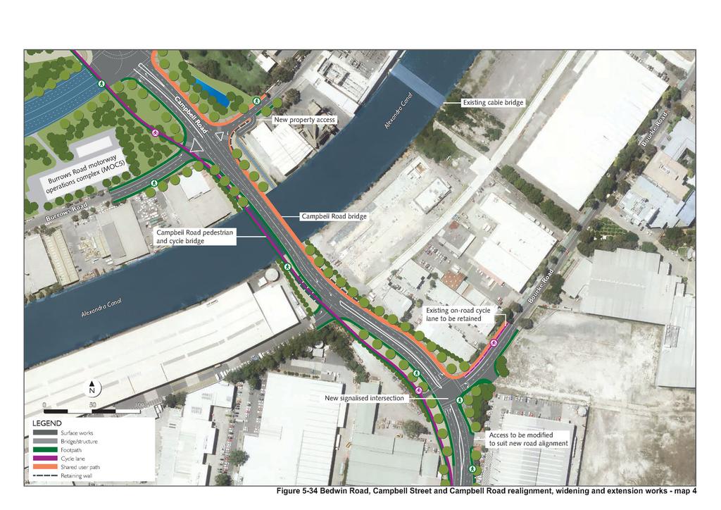
7 5.7.2 Realignment, widening and extension of Bedwin Road / Campbell Street / Campbell Road The upgrade of Bedwin Road / Campbell Street / Campbell Road would comprise the following key components: Realignment of Bedwin Road between the railway bridge and the Unwins Bridge Road / Campbell Street / May Street intersection Widening of Campbell Street / Campbell Road between Unwins Bridge Road and Burrows Road Extension of Campbell Road eastwards over the Alexandra Canal to connect to Bourke Road, Mascot Upgrades to intersections along Bedwin Road / Campbell Street / Campbell Road. Realignment of Bedwin Road Bedwin Road would be realigned between the railway bridge near Camdenville Park, and the intersection with Unwins Bridge Road / May Street / Campbell Street. The realignment would remove two existing tight curves and improve the overall alignment of Bedwin Road. The realignment of Bedwin Road would result in the intersection of Bedwin Road with Unwins Bridge Road / May Street / Campbell Street moving about 20 metres to the south of its current location. Further details of the intersection upgrade works are provided below. Details of the realignment works are shown in Figure Widening of Campbell Street / Campbell Road Campbell Street / Campbell Road is currently one traffic lane in each direction with the kerb side providing parking along Campbell Road. Campbell Street / Campbell Road would be widened in three sections: Between Unwins Bridge Road and the Princes Highway to provide two traffic lanes in each direction, separated by line marking or a median in some places Between the Princes Highway and Euston Road to provide three traffic lanes in each direction. Eastbound and westbound traffic lanes would be separated by a median, which would be provided at variable widths to accommodate turning lanes at intersections Between Euston Road and Burrows Road to provide two lanes in each direction, separated by a median. All traffic lanes would be around three metres wide. A parallel parking lane of around 2.5 metres would be provided in both directions along Campbell Street between Hutchinson Street and St Peters Street. Additional on-street and off street car parking spaces would be provided between St Peters Street and Church Street. Pedestrian footpaths would be provided in each direction along Campbell Street / Campbell Road. Between the May Street and Barwon Park Road, a separate cycle path would be provided along the northern side of Campbell Street / Campbell Road as part of a broader series of works to improve pedestrian and cyclist accessibility around Sydney Park (refer to Section 5.7.9). Campbell Road would be realigned between Euston Road and Burrows Road, moving it around 50 metres to the south of its current location. This realignment would be required to connect to the extension of Campbell Road over the Alexandra Canal (refer below). The majority of works required to widen Campbell Street / Campbell Road would be conducted in the existing road reserve along the southern side of Campbell Street / Campbell Road (westbound carriageway). The kerbside lanes on Campbell road have been designed such that they could be converted to bus lanes if and when required in medium to long term. Details of the widening works are shown in Figure 5-32 to Figure WestConnex New M5 5-87
8 Extension of Campbell Road across the Alexandra Canal Campbell Road would be extended eastwards to provide a direct connection to Bourke Road, Alexandria via a bridge over the Alexandra Canal (the Campbell Road bridge). The extension of Campbell Road would terminate at a new intersection with Bourke Road and would comprise two eastbound lanes, two westbound lanes and a median. The westbound carriageway of the Campbell Road extension would include an 80 metre long right-turn lane for vehicles to turn right into Euston Road. Traffic lanes in both directions would be about three metres wide. A shared pedestrian and cycle path would be provided on the northern side of Campbell Road (eastbound carriageway). A pedestrian footpath would be provided on the southern side (westbound carriageway). A separate pedestrian and cycle bridge would also be provided along the southern side of the Campbell Road bridge as part of a broader series of works to improve pedestrian and cyclist accessibility around Sydney Park (refer to Section 5.7.9). Bedwin Road / Campbell Street / Campbell Road intersection modifications As part of the Bedwin Road / Campbell Street / Campbell Road upgrade, widening and extension works, the following intersections would be modified: The Bedwin Road / Campbell Street / Unwins Bridge Road / May Street intersection The Campbell Street / Brown Street intersection The Campbell Street / Hutchinson Street intersection The Campbell Street / Florence Street intersection The Campbell Street / St Peters Street intersection The Campbell Street / Church Street intersection The Campbell Street / Princes Highway intersection The Campbell Street / Crown Street intersection The Campbell Street / Albert Street intersection The Campbell Street / Campbell Road/ Barwon Park Road intersection The Campbell Road / Harber Street intersection The Campbell Road / Euston Road intersection (also detailed in Section in relation to intersection upgrades along Euston Road) The Campbell Road / Burrows Road intersection The new Campbell Road (extension) / Bourke Road intersection The new Campbell Road (extension) / Southend Distribution Centre. Modification works at these intersections are summarised in Table 5-5 and shown in Figure 5-31 to Figure An assessment of the traffic and transport related impacts associated with these intersection upgrades are provided in Chapter 9 (Traffic and transport) and Appendix G (Technical working paper: Traffic and transport). WestConnex New M5 5-88
9 Table 5-5 Intersection Bedwin Road / Campbell Street / Unwins Bridge Road / May Street Campbell Street / Brown Street Campbell Street / Hutchinson Street Campbell Street / Florence Street Campbell Street / St Peters Street Campbell Street / Church Street Campbell Street / Princes Highway Campbell Street / Albert Street / Albert Street / Princes Highway Campbell Street / Campbell Road / Barwon Park Road Bedwin Road / Campbell Street / Campbell Road intersection works Modification works Realignment of the intersection to the north east of its current location Construction of a new left-hand turn from Campbell Street into Unwins Bridge Road Extension of the left-turn lane from Unwins Bridge Road into Bedwin Road Construction of a new shared left and through lane on May Street southbound Removal of the high angle left turn from May Street into Campbell Street and replacement with a shared through/ left turn lane New right turn from Campbell Street into May Street. Left-in, left-out (westbound) turning provisions only Alternative access would be available via Conway Place and Unwins Bridge Road. The existing left-in one way arrangements would be maintained with realignment of the intersection Left-in, left-out (westbound) turning provisions only Inclusion of a median along Campbell Street to reinforce turning movements Alternative access would be available via Silver Street and Unwins Bridge Road. Upgrade to signalised intersection, catering for all turning movements from and to Campbell Street Additional northbound lane to provide for left-turn and right-turn movements onto Campbell Street. Left-in, left-out (westbound) turning provisions only Inclusion of a median along Campbell Street to reinforce turning provisions Alternative access via Victoria Street. All turning movements would be provided, including: One southbound through lane of the Princes Highway would be converted to a right-turn lane for vehicles to turn into Campbell Street (westbound) Two high-angle left-turn lanes from Campbell Street westbound into Princes Highway (southbound) Additional right-turn lane from Princes Highway (northbound) into Campbell Street (eastbound) Conversion of Princes Highway (northbound) kerbside lane from through lane to shared through and left-turn movement into Campbell Street (westbound) One additional westbound and eastbound through lane along Campbell Street One additional right-turn lane from Campbell Street (westbound) into Princes Highway (northbound) Two new right-turn lanes from Campbell Street (eastbound) into Princes Highway (southbound). Upgrade to a signalised intersection to cater for the future M4-M5 Link construction Right-turn (eastbound) turning provisions into Albert Street New right-hand turn lanes on Campbell Street (eastbound) to provide access for future M4-M5 Link construction works in the St Peters interchange site Left-in, left-out (westbound) turning provisions only. Barwon Park Road would become one way, with only left in permitted. WestConnex New M5 5-89
10 Intersection Campbell Road / Harber Street Campbell Road / Euston Road (refer also to Section 5.5.2) Campbell Road / Burrows Road Campbell Road (extension) / Bourke Road Campbell Road / Southend Distribution Centre Modification works Closure of Harber Street to the south of Campbell Road Left-in, left-out turning provisions only for eastbound traffic. Upgrade from an un-signalised three way junction to a signalised four way junction Tie-in works to connect with the on and off ramps for the main alignment tunnels and the local road network Additional lanes, including dedicated right-hand and left-hand turning lanes would be provided. Left-in, left-out only Alternative access to Burrows Road north of Campbell Road via Huntley Street Alternative access to Burrows Road south of Campbell Road via Canal Road. A new signalised T-intersection at the junction of the Campbell Road extension and Bourke Road Bourke Road northbound would include two through lanes and one rightturn lane Bourke Road southbound would include one left-turn lane and one rightturn lane Campbell Road would include one left turn lane and two through lanes. A new T-intersection at the junction of the Campbell Road extension and the distribution centre access road Campbell Road eastbound would include two through lanes and one rightturn lane Campbell Road westbound would include one through lane and one shared through and left-turn lane Distribution centre egress would be left-out only. WestConnex New M5 5-90
11
12 (blank page) WestConnex New M5 5-92
13
14 (blank page) WestConnex New M5 5-94

15
16 (blank page) WestConnex New M5 5-96
17
18 (blank page) WestConnex New M5 5-98
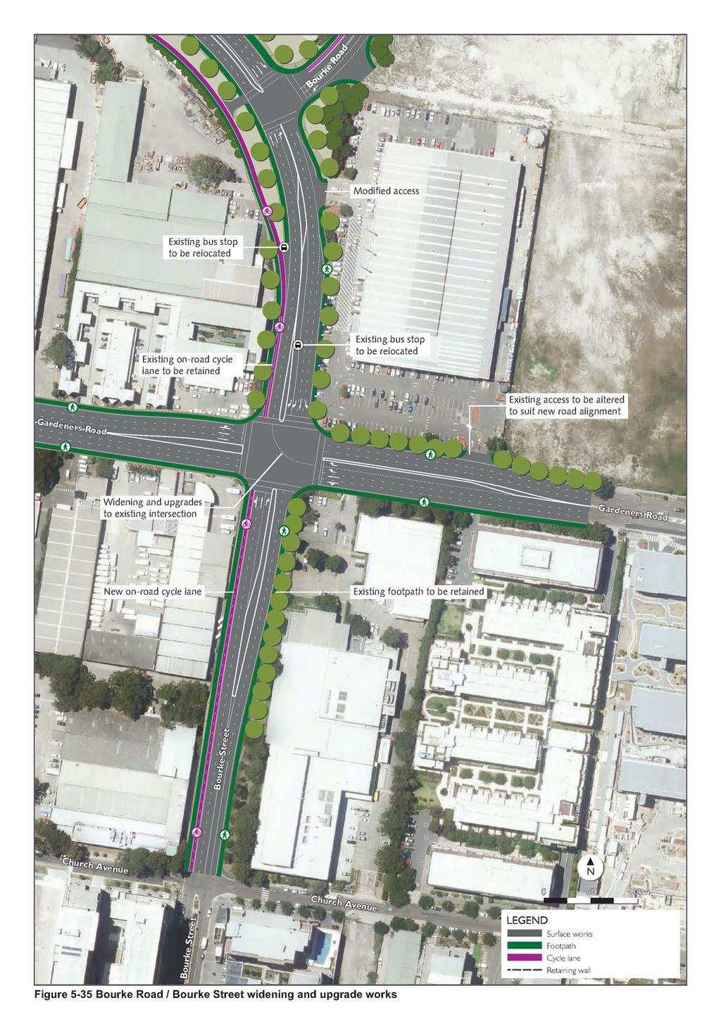
19 5.7.3 Upgrade and widening of Bourke Road / Bourke Street The upgrade of Bourke Road / Bourke Street would comprise the following key components: Widening of Bourke Road between the new intersection with the Campbell Road extension and the intersection with Gardeners Road Widening of Bourke Street between the intersection with Gardeners Road and the intersection with Church Avenue A new intersection where the Campbell Road extension meets Bourke Road and upgrades to the intersection of Bourke Road / Bourke Street with Gardeners Road. Widening of Bourke Road Bourke Road would be upgraded and widened from around 100 metres north of the new intersection with the Campbell Road extension to the intersection with Gardeners Road. Two traffic lanes would be provided in the southbound direction with a single lane retained northbound. Each lane would be about three metres wide. In the southbound direction, two additional lanes would be provided near the intersection with Gardeners Road to allow for left-hand and right-hand turning movements into Gardeners Road. In the northbound direction, a right-hand tuning lane would be provided near the intersection with the Campbell Road extension to allow traffic to turn into Bourke Road north rather than continue along the Campbell Road extension over Alexandra Canal. Pedestrian footpaths would be provided in both directions. A separate cycle path would be provided along the western side of Bourke Road, adjacent to the pedestrian footpath. Details of the widening works are shown in Figure Widening of Bourke Street Bourke Street would be upgraded and widened from the intersection with Gardeners Road to around the intersection with Church Avenue. Two through traffic lanes would be provided in each direction and a right hand turn lane northbound to the eastbound Gardeners Road. Each lane would be three metres wide. Pedestrian footpaths would be provided in both directions. A separate cycle path would be provided along the western side of Bourke Street, adjacent to the pedestrian footpath. Details of the widening works are shown in Figure Bourke Road / Bourke Street intersection upgrades As part of the upgrade and widening of Bourke Road / Bourke Street, the following intersection works would be carried out: Provision of a new intersection between Bourke Road and the Campbell Road extension (also detailed in Section in relation to intersection upgrades along Campbell Road) Upgrade of the Bourke Road / Bourke Street / Gardeners Road intersection. Intersection works at these locations are summarised in Table 5-6 and shown in Figure WestConnex New M5 5-99
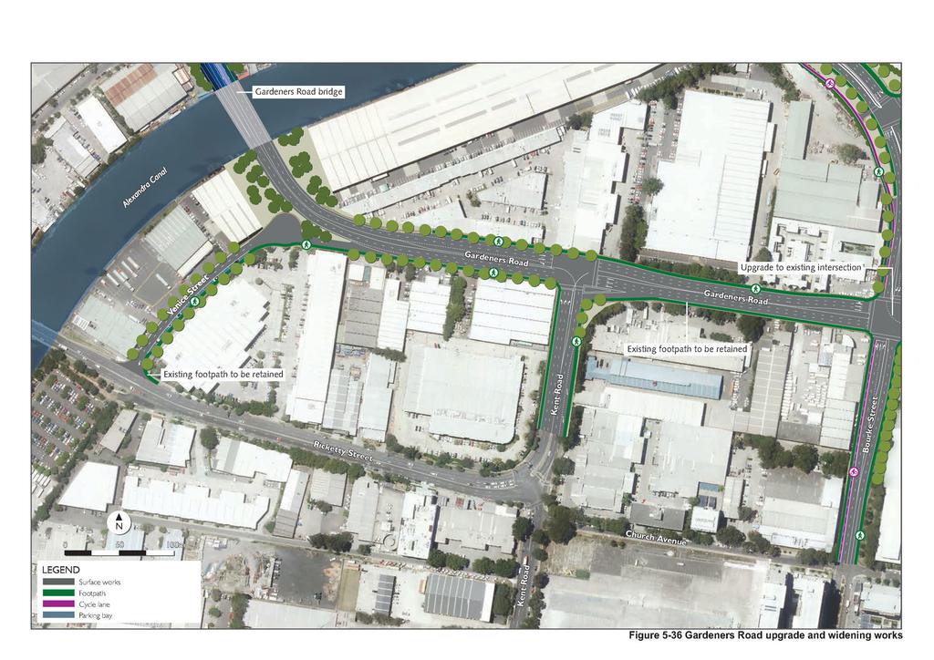
20 Table 5-6 Intersection Bourke Road / Campbell Road (extension) Bourke Road / Bourke Street / Gardeners Road Gardeners Road Bourke Road / Bourke Street intersection works Upgrade works A new signalised T-intersection at the junction of the Campbell Road extension and Bourke Road Bourke Road northbound would include two through lanes and one right-turn lane Bourke Road southbound would include one left-turn lane and one right-turn lane Campbell Road would include one left turn lane and two through lanes. Bourke Street northbound would be widened from one lane to three lanes and would include one combined left / through lane, one through lane and one right turn lane Bourke Road southbound would be widened from two to four lanes and would include one dedicated left-turn lane, one through lane and two rightturn lanes Gardeners Road eastbound would include one shared left-turn / through lanes and two through lanes Gardeners Road westbound would be widened from three lanes to four to provide an additional right-turn lane into Bourke Road northbound Gardeners Road would be widened in the vicinity of the upgraded Bourke Road / Bourke Street / Gardeners Road intersection to accommodate an additional through lane for westbound traffic, a new concrete median between the eastbound and westbound carriageways and two right-turn lanes for westbound traffic to turn into Bourke Road. These widening works would generally be undertaken along the northern side of Gardeners Road. Details of the widening works are shown on Figure East of Kent Road, Gardeners Road is currently two lanes in each direction. Gardeners Road would be widened to three lanes in each direction between the Gardeners Road bridge over the Alexandra Canal to east of the intersection with Bourke Road / Bourke Street. All turning movements would be provided at the Gardeners Road / Kent Road intersection, including: Three through lanes on Gardeners Road (eastbound) One right-turn lane on Gardeners Road (eastbound) onto Kent Road (southbound) Two right-turn lanes on Kent Road (northbound) onto Gardeners Road (eastbound) One left-turn lane on Kent Road (northbound) onto Gardeners Road (westbound). These widening works would generally be undertaken along the northern side of Gardeners Road. All lanes would be around three metres wide. WestConnex New M
21
22 (blank page) WestConnex New M
23
24 (blank page) WestConnex New M
25 5.7.5 Other minor local road upgrades As a consequence of local road upgrades, minor changes to other local roads would be required. These changes would include: Construction of Venice Street Minor upgrade works on Unwins Bridge Road and May Street Minor upgrade works on Albert Street Some permanent road and intersection closures. Venice Street The existing driveway located between three Ricketty Street, Mascot and five Ricketty Street, Mascot would be extended to form Venice Street. Venice Street would provide access to properties between Ricketty Street and Gardeners Road and would be one lane in each direction with a turning head at the northern end. Vehicles travelling westbound along Gardeners Road would be able to turn left into Venice Street via a slip lane, allowing vehicles to travel southbound along Venice Street and turn into Ricketty Street. Venice Street would comprise two lanes, about three metres wide and a pedestrian footpath along the eastern (southbound) side of the street. The northbound lane of Venice Street would provide access to properties. However, no vehicles would be able to turn into Gardeners Road from Venice Street. Upgrade works on Unwins Bridge Road and May Street The upgrade of the Bedwin Road / Campbell Street / Unwins Bridge Road / May Street intersection would require minor localised upgrades along Unwins Bridge Road and May Street. These upgrades would extend around 150 metres from the upgraded intersection would include: Unwins Bridge Road northbound: extension of the high angle left turn lane by about 80 metres May Street northbound: extension of the second through lane from the upgraded Bedwin Road / Campbell Street / Unwins Bridge Road / May Street intersection May Street southbound: extension of the second through lane from the upgraded Bedwin Road / Campbell Street / Unwins Bridge Road / May Street intersection for about 100 metres. The localised upgrade works on Unwins Bridge Road and May Street would be carried out along the western side of these roads. The widening of May Street would require partial acquisition of Camdenville Park. Details of these minor upgrade works are shown in Figure Camdenville Park would also be occupied during construction of the project in order to upgrade the existing detention basin within the park. Following completion of construction, BMX facilities would be provided at Camdenville Park or as agreed with Marrickville Council. Upgrade works on Albert Street Albert Street is currently open to eastbound traffic only between the Princes Highway and Holland Lane, and two-way traffic between Holland Lane and Campbell Road. As part of the local road upgrades, Albert Street would maintain one-way traffic movements between the Princes Highway and Campbell Road. Car parking would not be provided along Albert Street following completion of the project. Details of these minor upgrade works are shown in Figure WestConnex New M
26 Permanent road and intersection closures The local road upgrade works would require the permanent closure of the following roads and intersections: Harber Street between Holland Street and Campbell Road Campbell Lane between Albert Street and Harber Street Woodley Street between Holland Street and Campbell Road Holland Street between Woodley Street and Harber Street The Campbell Road / Woodley Street intersection Bridges and structures The local road upgrades would include construction or upgrade of the following bridges and structures: A new bridge over the Alexandra Canal as part of the Campbell Road extension (Campbell Road bridge) A new grade separated pedestrian and cycle bridge over Campbell Road into Sydney Park, west of Euston Road extending from Sydney Park, west of Euston Road over Campbell Road and Alexandra Canal into Alexandria A cut and cover structure beneath Campbell Street and Albert Street to allow potential future construction of the future M4-M5 Link Widening of the Euston Road bridge over the Munni Street stormwater channel A new bridge over the Alexandra Canal as part of the Gardeners Road extension. Campbell Road bridge The Campbell Road bridge would be a three span grade separated girder bridge, extending around 130 metres across the Alexandra Canal. The substructure would comprise bored piles, piers and abutments. The superstructure would consist of steel box girders, precast concrete deck infill slabs with an in-situ deck and precast parapets. The location of the new Campbell Road bridge is shown in Figure An indicative cross-section of the new bridge is shown in Figure Campbell Road pedestrian and cycle bridge The Campbell Road pedestrian and cycle bridge would extend from the Bourke Road cycle path to Sydney Park. The bridge would be delivered as part of a broader series of works to improve pedestrian and cyclist accessibility around Sydney Park. The bridge would be made up of two main sections: Extending from Bourke Road, across Alexandra Canal to then run parallel to Campbell Road to around Campbell Lane. This section would: Be around 370 metres long and provide pedestrian and cycle access across the on- and offramps, as part of the St Peters interchange Comprise nine spans, including two long spans over the on-and off-ramps and over the Alexandra Canal. The substructure would comprise bored piles, piers and abutments. The superstructure would include steel box girders and beams. WestConnex New M
27 Extending across Campbell Road to Sydney Park. This section of the bridge would: Be around 60 metres long and four metres wide and would cross Campbell Road in a single span Include architectural features, comprising a sweeping arc, anti-throw screens, integrated pedestrian lighting and landscaping. The substructure would consist of bored piles and abutments built from the pile level. The superstructure would consist of a steel arch, precast floor slabs and an in-situ deck. The location of the new Campbell Road pedestrian and cycle bridge is shown in Figure 5-31 to Figure Cut and cover structure beneath Campbell Street and Albert Street A cut and cover structure underneath Campbell Street would be constructed near the intersection with Albert Street. The cut and cover structure would allow for the potential construction of the future M4- M5 Link at a later date. The structure would consist of bored piles as well as abutment and pier headstocks which would be cast around super T-beams forming an internal bridge. The location of the cut and cover structure is shown in Figure Widening of the Euston Road stormwater channel bridge The existing bridge structure which carries Euston Road over the Munni Street stormwater channel would be widened as part of the Euston Road widening works (refer to Section 5.7.1). The widening would utilise bridge components similar to the existing crossing. Gardeners Road bridge The Gardeners Road bridge over the Alexandra Canal would be a three span girder bridge, extending across the Alexandra Canal. The substructure would comprise bored piles, piers and abutments. The location of the new Gardeners Road bridge is shown in Figure WestConnex New M
28 (blank page) WestConnex New M
29 N S W BENNETT 1 N S W C VAHTRA 1 N S W T OSBORNE N S W C BENNETT CAMPBELL ROAD BRIDGE - ELEVATION WEST Approach slab Bridge abutment Shared path Reinforced concrete pier Reinforced concrete pier Shared path Bridge abutment Approach slab EAST Existing ground surface Existing ground surface ALEXANDRA CANAL NOT TO SCALE CAMPBELL ROAD BRIDGE OVER PIER - SECTION NORTH SOUTH Footpath Steel box girder Median Bridge deck Reinforced concrete pier Twin rail safety barrier Shared path Pedestrian safety fence Existing ground surface Existing ground surface NOT TO SCALE Figure 5-37 Indicative cross section - Campbell Road bridge
30 (blank page) WestConnex New M
31 5.7.7 Road infrastructure design The project has been designed generally in accordance with Australian Standards, the Austroads Guides, as well as Roads and Maritime design guides and supplements. The project has been designed to safely accommodate the design speeds listed in Table 5-7. These design traffic speeds are mostly higher than the actual posted speed limited that would be applied to each component of the project. Table 5-7 Location Design speeds and posted speed limits Design speed (kilometres per hour) Posted speed limit (kilometres per hour) New M5 Motorway Main alignment tunnels and ramps Local road upgrades Campbell Street, between Unwins Bridge Road and the Princes Highway Campbell Street, between the Princes Highway and Barwon Park Road Campbell Road between Barwon Park Road and Bourke Road (including the Campbell Road extension) Bourke Road, north of Campbell Road Bourke Road, between Campbell Road and Gardeners Road Bourke Street Euston Road Sydney Park Road Huntley Street Gardeners Road Unwins Bridge Road May Street Bedwin Road Burrows Road Heavy vehicle access arrangements The local road upgrades have been designed to allow movement of heavy vehicles in some areas, including: Single unit heavy vehicles a 12.5 metre long rigid vehicle, for example a bus Semi-trailer a heavy vehicle up to 19 metres in length, consisting of a prime mover and one articulated trailer B-doubles A heavy vehicle up to about 25 metres in length, consisting of a prime mover and two articulated trailers. The lead trailer is shorter and able to carry one 20 foot container and the second trailer is longer and able to carry two 20 foot containers or one 40 foot container Super B-doubles A B-double up to 32 metres long. A super B-double is configured the same as a B-double; however, the lead trailer is the same length as the second trailer, meaning that the vehicle is capable of carrying up to four 20 foot containers or two 40 foot containers. A summary of where local road upgrades have been designed to accommodate heavy vehicle turning movements is provided in Table 5-8. The turning provisions would allow for new heavy vehicle routes around St Peters to be designated via the relevant Roads and Maritime process if required. All other turning movements within the local road upgrades have been design to accommodate vehicles up to and including semi-trailers. WestConnex New M
32 Table 5-8 Suggested heavy vehicle turning provisions local road upgrades Heavy vehicle Location of turning movements type Super B- Right turn Princes Highway northbound into Campbell Street eastbound doubles Right turn Campbell Road eastbound into New M5 ramps southbound Right turn Campbell Road eastbound into Bourke Road southbound Left turn Bourke Road southbound into Gardeners Road eastbound. B-doubles All movements at the intersection of Campbell Road and Burrows Road. Single unit vehicles Semi-trailer All turning movements at the following intersections: Campbell Street and Brown Street Campbell Street and Hutchinson Street Campbell Street and Florence Street Campbell Street and St Peters Street Campbell Street and Church Street Campbell Street and Crown Street Campbell Street and Albert Street Princes Highway and Albert Street Campbell Road and Woodley Street Campbell Road and Harber Street. All other movements not specifically mentioned above Pedestrian and cycle access arrangements The local road upgrades would provide new and upgraded pedestrian and cycle infrastructure. This infrastructure has been designed to maintain and enhance pedestrian and cyclist accessibility and connectivity, particularly around the St Peters interchange and Sydney Park. The most significant new infrastructure would include the construction of the Campbell Road pedestrian and cycle bridge providing connections between Sydney Park and Bourke Road cycle path. Other key pedestrian and cycle infrastructure to be delivered as part of the local road upgrades would include: A shared path along the western side of Euston Road between Campbell Road and Sydney Park Road An on-road cycle lane along Bourke Road between Campbell Road and Church Avenue Retention of the on-road cycle lane on Bourke Road / Street, north of the Campbell Road extension Provision of footpaths along all local roads upgraded as part of the project. The upgrades to pedestrian and cycle infrastructure would provide for a safe cyclist and pedestrian environment by minimising the interface between cyclists, pedestrians and vehicular traffic, and would also provide a regional cycle connection between Mascot and Marrickville. Pedestrian and cycle infrastructure associated with the local road upgrades component of the project are shown on Figure 5-29 to Figure Changes to bus infrastructure The local road upgrades would provide the opportunity for potential future public transport connections between the Princes Highway, St Peters and Gardeners Road, Mascot via the Campbell Road extension. WestConnex New M
33 The bus stop on the southbound side of Canal Road along route 418 (Burwood to Bondi Junction) near the intersection of the Princes Highway would be permanently relocated further south along Canal Road to accommodate construction vehicles entering and exiting the Canal Road construction compound throughout construction of the project (refer to Section 6.9 for further details). The final location of this bus stop would be determined during detailed design and in consultation with Transport for NSW. The existing bus stop on Euston Road northbound, south of the intersection with Maddox Street would be temporarily relocated during the upgrade of Euston Road and Maddox Street. The bus stop would be would be reinstated after this work is completed. The project offers a flexible design which does not preclude bus priority measures being included in the future Roads and Maritime and TfNSW will continue to work together to deliver Sydney s Bus Future, which may be extended to this area in due course, at which point the surface road network can be adapted to include measures identified at a future date. 5.8 Motorway operational ancillary infrastructure The project would require permanent operational ancillary infrastructure including: Operational management control systems and incident and emergency response infrastructure Tunnel ventilation systems and facilities Drainage and water treatment facilities Noise attenuation measures Utilities Roadside furniture and lighting. Most operational ancillary infrastructure would be established in five main motorway operations complexes: The Kingsgrove motorway operations complex (MOC1) located to the south of the western project portals and the existing M5 East Motorway, on land previously occupied by the Kingsgrove South construction compound (C3) The Bexley Road South motorway operations complex (MOC2) located to the south of the M5 East Motorway western portals, adjacent to Bexley Road, on land previously occupied by the Bexley Road South construction compound (C5) The Arncliffe motorway operations complex (MOC3) located near the south western corner of the Kogarah Golf Course site, on land previously occupied by the Arncliffe construction compound (C7) The St Peters motorway operations complex (MOC4) located near the western corner of the St Peters interchange, adjacent to the Prince Highway / Canal Road intersection, on land previously occupied by the Canal Road construction compound (C8) The Burrows Road motorway operations complex (MOC5) located at the corner of Burrows Road and Campbell Road, St Peters on land previously occupied by the Burrows Road construction compound (C11). Noise attenuation measures, utilities, roadside furniture and lighting would be provided as required along the project corridor. The locations of the motorway operations complexes are shown in Figure 5-38 to Figure Operational ancillary infrastructure that would be located within each motorway operations complex is summarised in Table 5-9 and detailed in the following sections. WestConnex New M
34 Table 5-9 Summary of motorway operations complexes and operational ancillary infrastructure Operational ancillary facilities Motorway operations complex Kingsgrove (MOC1) Bexley Road South(MOC2) Arncliffe (MOC3) St Peters (MOC4) Burrows Road (MOC5) Ventilation facility Emergency smoke extraction facility Deluge water tanks Car parking Substation / power supply Emergency response system Maintenance facility Workshop / offices Storage Water treatment plant / infrastructure Motorway control centre Infrastructure required for the ongoing management of the former Alexandria Landfill, including landfill gas, leachate and other environmental control measures, are detailed in Section 5.9. WestConnex New M
35
36 (blank page) WestConnex New M
37
38 (blank page) WestConnex New M
39
40 (blank page) WestConnex New M
Day and night time road closures and traffic changes on Campbell Street and surrounding streets, St Peters from Monday 9 April to Friday 13 April
 New M5 Work notification 4 April 2018 Day and night time road closures and traffic changes on Campbell Street and surrounding streets, St Peters from Monday 9 April to Friday 13 April A significant amount
Concord Road Interchange. Standard hours of work
 Artist impression of the Concord Road interchange, Concord - concept only WestConnex s M4 East will extend the M4 Motorway with two new 5.5 kilometre tunnels from Homebush to Haberfield, providing a bypass
Dufferin Jog Elimination Project
 Project Project Status Update November 14 2007 Project History Planning Alternatives Criteria Measured Project Benefits Structural Configurations Considered Structural Design Considerations The Preferred
PART VIII APPLICATION FOR REVISED SOUTH SIDE TRAFFIC MANAGEMENT WORKS TO FACILITATE LUAS BXD PLANNING REPORT ROADS & TRAFFIC DEPARTMENT
 PART VIII APPLICATION FOR REVISED SOUTH SIDE TRAFFIC MANAGEMENT WORKS TO FACILITATE LUAS BXD PLANNING REPORT ROADS & TRAFFIC DEPARTMENT NOVEMBER 2012 1.0 INTRODUCTION This report has been prepared in support
A. CONCLUSIONS OF THE FGEIS
 Chapter 11: Traffic and Parking A. CONCLUSIONS OF THE FGEIS The FGEIS found that the Approved Plan will generate a substantial volume of vehicular and pedestrian activity, including an estimated 1,300
The Point Roundabout Improvement Scheme
 The Point Roundabout Improvement Scheme Background and Existing Situation The junction of North Wall Quay, East Wall Road and the East Link Bridge, also known as the Point roundabout, is located in the
Planning Approval Consistency Assessment Form
 Integrated Management System Planning Approval Consistency Assessment Form SM ES-FT-414 Sydney Metro Integrated Management System (IMS) Applicable to: Document Owner: System Owner: Status: Sydney Metro
Chapter 2 Route window W25 Maidenhead station. Transport for London
 Chapter 2 Route window W25 Maidenhead station MAIDENHEAD STATION 2 Route window W25 Maidenhead station 2.6 The drawings provided at the end of this chapter present the main features of the route window,
The implementation of this Master Plan will be undertaken in logical stages to meet passenger and workforce demands.
 The implementation of this Master Plan will be undertaken in logical stages to meet passenger and workforce demands. Connecting People Building Opportunities 198 Brisbane Airport Corporation CHAPTER 10
Day and night work: Hills M2 Motorway tunnel portals and Coral Tree Drive electrical substation
 T 1800 997 057 (free call) E enquiries@northconnex.com.au PO Box 343 Pennant Hills NSW 1715 northconnex.com.au 2 July 2018 Ref: N0202 Day and night work: Hills M2 Motorway tunnel portals and Coral Tree
A63 Castle Street, Hull HullBID Network Lunch 24 August 2017
 A63 Castle Street, Hull HullBID Network Lunch 24 August 2017 James D Leeming Senior Project Manager What we will cover today? Introduction to Highways England and the Road Investment Strategy A63 Scheme
Chapter 14 Route Window C12 Mile End Park and Eleanor Street shafts. Transport for London
 Chapter 14 Route Window C12 Mile End Park and Eleanor Street shafts MILE END PARK AND ELEANOR STREET SHAFTS 14 Route Window C12 Mile End Park and Eleanor Street shafts Introduction 14.1 Crossrail s twin
7.0 GROUND TRANSPORT DEVELOPMENT PLAN OVERVIEW. Sydney Airport Master Plan
 7.0 GROUND TRANSPORT DEVELOPMENT PLAN OVERVIEW Sydney Airport Master Plan 2033 87 7.0 GROUND TRANSPORT DEVELOPMENT PLAN OVERVIEW Key points On Airport Drive, non-airport through-traffic accounts for up
EXTERNAL COMMUNICATIONS TEAM MEETING MARCH 2015
 EXTERNAL COMMUNICATIONS TEAM MEETING MARCH 2015 1 SEGMENT 1 2 THE WISHBONE Connects the TEXpress Managed Toll System to the 35Express Managed Toll System Limits: Crown Road (near Royal Lane) to Valley
Proposed Bicycle Lanes on Yonge Street from Queens Quay to Front Street
 STAFF REPORT ACTION REQUIRED Proposed Bicycle Lanes on Yonge Street from Queens Quay to Front Street Date: March 12, 2007 To: From: Toronto and East York Community Council Director, Transportation Infrastructure
Route 29 Solutions Projects
 Your guide to the Route 29 Solutions Projects For full details & continued engagement please visit www.route29solutions.org The Route 29 Solutions Package is a $230 million investment into the improvement
Newcastle Transport Program Newcastle Light Rail Determination Report
 Newcastle Transport Program Newcastle Light Rail Determination Report Date Author 25 July 2016 TfNSW Ref 5276649 Status Final TfNSW 2014 UNCONTROLLED WHEN PRINTED Page 1 of 19 Table of contents 1 Introduction
Gold Coast. Rapid Transit. Chapter content. Chapter four Route selection and staging
 Chapter four Route selection and staging Gold Coast Rapid Transit Chapter four Route selection and staging Chapter content Route selection...73 Section one: Helensvale to Griffith University...74 Section
How is air quality managed. in Sydney s road tunnels?
 How is air quality managed in Sydney s road tunnels? The Sydney Orbital Network includes over 160 kilometres of surface roads, tunnels, bridges and underpasses. There are five main tunnels along the network;
EXTERNAL COMMUNICATIONS COMMITTEE MEETING APRIL 2015
 EXTERNAL COMMUNICATIONS COMMITTEE MEETING APRIL 2015 35EXPRESS PROJECT OVERVIEW 2 SEGMENT 1 3 SOUTH OF I-635 May Shift northbound mainlane traffic east in the southeast quadrant Miscellaneous frontage
November 21, 2012 Barbara Kelleher, (954)
") November 21, 2012 Barbara Kelleher, (954) 777-4090 barbara.kelleher@dot.state.fl.us BROWARD COUNTY TRAFFIC IMPACT REPORT November 26 to November 30, 2012 FORT LAUDERDALE -- Construction and maintenance-related
November 21, 2012 Barbara Kelleher, (954) 777-4090 barbara.kelleher@dot.state.fl.us BROWARD COUNTY TRAFFIC IMPACT REPORT November 26 to November 30, 2012 FORT LAUDERDALE -- Construction and maintenance-related
Hospital Link Project Project Update Winter 2018
 Hospital Link Project Project Update Winter 2018 General The project provides a link from Riverside Drive and the Transitway to the Hospital Link Road. Construction of the Hospital Link facility is open
4. Safety Concerns Potential Short and Medium-Term Improvements
 NH Route 104 Access Management Study Page 19 4. Safety Concerns Potential Short and Medium-Term Improvements Potential safety improvement strategies are listed by priority based on field observations by
Major Scheme Business Case Summary Report for Programme Entry
 Paper A Heart of South West Local Transport Board Major Scheme Business Case Summary Report for Programme Entry M5 Junction 25, Taunton July 2016 1 SCHEME SUMMARY Scheme Name M5 Junction 25, Taunton Date
To: From: Plans showing the alignments of the routes discussed in this section are presented in Appendix A.
 Project: Cambourne to Cambridge Better Bus Journeys To: CCC Subject: Considerations for Corridor Option Plans From: Atkins Date: 1 Sep 2016 cc: 1. Introduction This note summarises considerations undertaken
Night work update: Hills M2 Motorway and westbound on ramp at Pennant Hills Road
 T 1800 997 057 (free call) E enquiries@northconnex.com.au PO Box 343 Pennant Hills NSW 1715 northconnex.com.au 28 April 2017 Ref: N0075M Night work update: and westbound on ramp at Dear resident, NorthConnex
RW Bruhn Bridge and Approaches Project
 RW Bruhn Bridge and Approaches Project The Trans-Canada Highway 1 RW Bruhn Bridge and Approaches Project involves four-laning approximately 1.9 km of Highway 1 in Sicamous, including replacement of the
FDOT Treasure Coast Traffic Impact Report
 July 22, 2016 Chuck McGinness, 954-777-4302 chuck.mcginness@dot.state.fl.us FDOT Treasure Coast Traffic Impact Report July 22 through July 29, 2016 TREASURE COAST Construction and maintenance-related lane
Part four. In this part you will find: The next steps to deliver the master plan
 Part four NEXT STEPS In this part you will find: The next steps to deliver the master plan 6. How COULD the Master Plan be delivered? There are a number of steps required to take the proposals in the master
Monthly Traffic Update
 Brisbane Airport Corporation Monthly Traffic Update PAGE 1 ISSUE 26 DECEMBER 2009 Northern Access Road Project opens 3 December Brisbane Airport Corporation (BAC) is pleased to announce that after two
Construction Staging Area Blue Jays Way (357 King Street West)
") REPORT FOR ACTION Construction Staging Area Blue Jays Way (357 King Street West) Date: June 8, 2018. To: Toronto and East York Community Council From: Acting Director, Transportation Services, Toronto
REPORT FOR ACTION Construction Staging Area Blue Jays Way (357 King Street West) Date: June 8, 2018. To: Toronto and East York Community Council From: Acting Director, Transportation Services, Toronto
Prince Albert Road Towpath Ramp, Camden Feasibility Report
 Prince Albert Road Towpath Ramp, Camden Feasibility Report Function Location: RE-004 Date: 25 October 2012 Report No: 5016-UA003174-UT31R-03 Prince Albert Road Towpath Ramp, Camden Feasibility Report
FDOT Treasure Coast Traffic Impact Report March 25 through April 1, 2016
 March 25, 2016 Chuck McGinness, 954-777-4302 chuck.mcginness@dot.state.fl.us FDOT Treasure Coast Traffic Impact Report March 25 through April 1, 2016 TREASURE COAST Construction and maintenance-related
Neighbourhood Committee NDG - Westmount. September 12, 2016
 Neighbourhood Committee NDG - Westmount September 12, 2016 2 Presentation Outline Requests from the committee members Feedback on previous questions Work update and hindrance of the Turcot Project Ministry
December 2012 Update. I-95 New Haven Harbor Crossing. Corridor Improvement Program
 December 2012 Update I-95 New Haven Harbor Crossing Corridor Improvement Program Prepared by: Connecticut Department of Transportation District 3A 424 Chapel Street New Haven, CT 06511 Prepared for: South
EXPLANATORY STATEMENT
 THE LONDON TO FISHGUARD TRUNK ROAD (A40) (PENBLEWIN TO SLEBECH PARK IMPROVEMENT) ORDER 200- AND THE LONDON TO FISHGUARD TRUNK ROAD (A40) (PENBLEWIN TO SLEBECH PARK IMPROVEMENT SIDE ROADS) ORDER 200-1.
QUALITY + LOCATION SOUTHEND DISTRIBUTION CENTRE 697 GARDENERS ROAD, MASCOT NSW
 QUALITY + LOCATION SOUTHEND DISTRIBUTION CENTRE 697 GARDENERS ROAD, MASCOT NSW OVERVIEW 2 Opportunity Southend Distribution Centre caters for small to medium industrial users. Well positioned, the estate
Sky Temporary Car Park Transport Statement
 001 Issue 26 August 2016 This report takes into account the particular instructions and requirements of our client. It is not intended for and should not be relied upon by any third party and no responsibility
Chapter 16 Route Window NE15 Brentwood station. Transport for London
 Chapter 16 Route Window NE15 Brentwood station BRENTWOOD STATION 16 Route Window NE15 Brentwood station Introduction 16.1 The construction activities in this route window are associated with minor refurbishment
BUILD. In this issue: NEW AERIALS OF CONSTRUCTION NEW PROJECT IN CONSTRUCTION PAC K AG E 4. August 2018
 BUILD C O N ST R U C T I O N Update August 2018 In this issue: NEW AERIALS OF CONSTRUCTION NEW PROJECT IN CONSTRUCTION PAC K AG E 4 AVENUE 12 CEDAR VIADUCT A VIEW FROM ROAD 27 ABOVE HSR CONSTRUCTION FRESNO
Northern Beaches Transport Action Plan
 Northern Beaches Transport Action Plan The NSW Government is taking action now to deliver transport improvements for the Northern Beaches, as well as planning for the future growth of the area. $633 million
FDOT Treasure Coast Traffic Impact Report June 19 through June 26, 2015
 June 19, 2015 Chuck McGinness, 954-777-4302 chuck.mcginness@dot.state.fl.us FDOT Treasure Coast Traffic Impact Report June 19 through June 26, 2015 TREASURE COAST Construction and maintenance-related lane
FDOT Treasure Coast Traffic Report through
 FDOT Treasure Coast Traffic Report 02 26 16 through 03 04 16 Kathleen Dempsey Fri 2/26/2016 2:56 PM To:Kathleen Dempsey ; 1 attachment 355 KB CR 714_Median Access Modifications.pdf;
PRIORITIES COMMITTEE MEETING
 PRIORITIES COMMITTEE MEETING Meeting Date: 05/13/14 Agenda Item #: 13.1 Northeast Anthony Henday Drive Update Report Purpose To update the Priorities Committee on the progress of the Northeast Anthony
As the Toronto Transit Commission (TTC) operates a transit service on Bay Street, City Council approval of this report is required.
 operates a transit service on Bay Street, City Council approval of this report is required.") REPORT FOR ACTION Construction Staging Area - 81 Bay Street Date: December 11, 2017 To: Toronto and East York, Community Council From: Acting Director, Transportation Services Toronto and East York District
REPORT FOR ACTION Construction Staging Area - 81 Bay Street Date: December 11, 2017 To: Toronto and East York, Community Council From: Acting Director, Transportation Services Toronto and East York District
Hospital Link Project Project Update September 2015
 Hospital Link Project Project Update September 2015 General The project provides a link between Riverside Drive and the Transitway to the Hospital Ring Road. This link is needed to improve transit service
LLANBEDR ACCESS IMPROVEMENTS
 LLANBEDR ACCESS IMPROVEMENTS NON-MOTORISED USER SUPPLEMENTARY REPORT CPF: 5111 Client: Gwynedd Council Document Control Sheet Document Title: Document Author: Project Manager: Project Title: A496 Llanbedr
Northeast Anthony Henday Drive Edmonton Ring Road Update. Strathcona Chamber of Commerce March 18, 2015
 Northeast Anthony Henday Drive Edmonton Ring Road Update Strathcona Chamber of Commerce March 18, 2015 Project Background 2 Edmonton Ring Road Northwest opened Nov 2011 Northeast to open Oct 2016 Southwest
Maidenhead Bridge. Proposed Work
 W1.1 Maidenhead Bridge Proposed Work The Maidenhead Bridge over the River Thames at Maidenhead is a Grade II* listed structure. Installation of overhead electrification on top of the structure would be
CUMULATIVE IMPACTS CHAPTER TWENTY-SIX
 CUMULATIVE IMPACTS CHAPTER TWENTY-SIX 26 Cumulative impacts This chapter provides an assessment of the potential cumulative impacts as a result of the project, and identifies mitigation measures to minimise
FDOT Treasure Coast Traffic Impact Report October 9 through October 16, 2015
 From: Kathleen Dempsey To: Kathleen Dempsey Subject: FDOT Treasure Coast Traffic Report 10 09 15 through 10 16 15 Date: Friday, October 09, 2015 2:10:36 PM Attachments: image003.png CR 714_Median Construction
LYNDHURST NEW URBAN DEVELOPMENT AREA STRUCTURE PLAN. Lyndhurst New Urban Development Area Structure Plan OUTCOMES AND PERFORMANCE STANDARDS
 APPENDIX 15.1-3 LYNDHURST NEW URBAN DEVELOPMENT AREA STRUCTURE PLAN Purpose of the Structure Plan Lyndhurst New Urban Development Area Structure Plan OUTCOMES AND PERFORMANCE STANDARDS LSP-P1 The District
Chapter 4 Route Window NE3 Manor Park station. Transport for London
 Chapter 4 Route Window NE3 Manor Park station MANOR PARK STATION 4 Route Window NE3 Manor Park station 4.7 Highway access to Manor Park station is very good. A117 Station Road connects with A116 to the
Chapter 8 Route Window NE7 Chadwell Heath station. Transport for London
 Chapter 8 Route Window NE7 Chadwell Heath station Transport CHADWELL HEATH STATION 8 Route Window NE7 Chadwell Heath station Baseline conditions 8.6 This route window lies within the London Boroughs of
Chapter 21 Route window W6 West Ealing station. Transport for London
 Chapter 21 Route window W6 West Ealing station WEST EALING STATION 21 Route window W6 West Ealing station Baseline conditions 21.6 West Ealing station is located in the London Borough of Ealing and is
WestConnex. 6 - The Roadbuilder. Specialist hydrology & meteorology expertise & services Field sampling Training Environmental monitoring
 WestConnex As peak production edges closer on Australia s largest transport infrastructure project, there is now a 3,600-strong workforce helping to deliver WestConnex. Local businesses and suppliers are
City of Sydney (COS) Bridges - an Overview & Current Asset Management Practices
 Bridges - an Overview & Current Asset Management Practices") City of Sydney (COS) Bridges - an Overview & Current Asset Management Practices Nasser Hossain Senior Engineer, Roads & Structural Assets, City of Sydney City of Sydney (COS) LGA The City of Sydney LGA
City of Sydney (COS) Bridges - an Overview & Current Asset Management Practices Nasser Hossain Senior Engineer, Roads & Structural Assets, City of Sydney City of Sydney (COS) LGA The City of Sydney LGA
May 1, 2015 Meredith Cruz, (561) Palm Beach County Traffic Report May 1 through May 8, 2015
 Palm Beach County Traffic Report May 1 through May 8, 2015") May 1, 2015 Meredith Cruz, (561) 641-6440 mcruz@corradino.com Palm Beach County Traffic Report May 1 through May 8, 2015 Palm Beach County Palm Beach County traffic will be affected this week by ongoing
May 1, 2015 Meredith Cruz, (561) 641-6440 mcruz@corradino.com Palm Beach County Traffic Report May 1 through May 8, 2015 Palm Beach County Palm Beach County traffic will be affected this week by ongoing
Pattullo Bridge Replacement Project
 Pattullo Bridge Overview This document will: Explain the challenges facing the Pattullo Bridge today Share how we propose moving forward translink.ca PAGE 1 History By Order of the Lieutenant Governor
Palm Beach County Traffic Report July 13 through July 20, 2012
 For Immediate Release July 13, 2012 Meredith Cruz, (561) 641-6440 mcruz@corradino.com Palm Beach County Traffic Report July 13 through July 20, 2012 Palm Beach County Palm Beach County traffic will be
Christ Church Grammar School, Claremont
 Christ Church Grammar School, Claremont TRAFFIC MANAGEMENT AND TRANSPORT PLAN Prepared for CHRIST CHURCH GRAMMAR SCHOOL Prepared by Uloth and Associates 11 Sep 2014; Updated 17 Aug 2015; 29 July 2016,
RE: Victoria Road upgrade (RTA December 2007). Thank you for the briefing from your department and the invitation to comment on the above.
. Thank you for the briefing from your department and the invitation to comment on the above.") Iain Macleod Project Manager Victoria Road upgrade Roads and Traffic Authority PO Box 743 Drummoyne NSW 1470 e : Victoria_Road_Info@rta.nsw.gov.au 21 February 2008 RE: Victoria Road upgrade (RTA December
Iain Macleod Project Manager Victoria Road upgrade Roads and Traffic Authority PO Box 743 Drummoyne NSW 1470 e : Victoria_Road_Info@rta.nsw.gov.au 21 February 2008 RE: Victoria Road upgrade (RTA December
IEC BOARDWALK CYCLEWAY FEASIBILITY STUDY
 1 IEC BOARDWALK CYCLEWAY FEASIBILITY STUDY The aim of this study is to review the role and value of including a cycleway in the proposed boardwalk under the Island Eastern Corridor, and then to consider
D L R C C T R A F F I C N E W S
 D L R C C T R A F F I C N E W S Saturday, 23 rd September 2017 to Friday, 29 th September 2017 A public service provided by Municipal Services Department of Dún Laoghaire-Rathdown County Council. Listed
A travel description of the Brisbane Airport Domestic Terminal Precinct. Author: Mr Terry Boyle of the Tactual Mapping Committee (September 2013)
") A travel description of the Brisbane Airport Domestic Terminal Precinct Author: Mr Terry Boyle of the Tactual Mapping Committee (September 2013) Brisbane Airport is located approximately 18 kilometres
A travel description of the Brisbane Airport Domestic Terminal Precinct Author: Mr Terry Boyle of the Tactual Mapping Committee (September 2013) Brisbane Airport is located approximately 18 kilometres
places Mooloolaba s heart five
 five places the mooloolaba heart 1 Flexible community event use of school oval 2 Enhanced streetscape District cycle route Future cross-block pedestrian link 5 Existing school buildings New signalised
TERMINAL DEVELOPMENT PLAN
 5.0 TERMINAL DEVELOPMENT PLAN 5.0 TERMINAL DEVELOPMENT PLAN Key points The development plan in the Master Plan includes the expansion of terminal infrastructure, creating integrated terminals for international,
OPPORTUNITY+ LOCATION HERITAGE BUSINESS PARK 5 9 RICKETTY STREET, MASCOT NSW
 OPPORTUNITY+ LOCATION HERITAGE BUSINESS PARK 5 9 RICKETTY STREET, MASCOT NSW OVERVIEW 2 Opportunity Heritage Business is one of South Sydney s most prominent estates offering high quality office and warehouse
Seek the Board s approval for the Donald Place kerb and channel renewal to progress to final design, tender and construction; and
 3. DONALD PLACE - KERB AND CHANNEL RENEWAL General Manager responsible: General Manager City Environment Officer responsible: Transport and City Streets Manager Author: Michelle Flanagan, Streets Capital
M56. New Junction 11a Summary of the consultation report
 M56 New Junction 11a Summary of the consultation report August 2017 M56 New Junction 11a Summary of the public consultation The scheme The M56 New Junction 11a scheme is part of our continued programme
Pedestrian Safety Review Spadina Avenue
 STAFF REPORT ACTION REQUIRED Pedestrian Safety Review Spadina Avenue Date: October 13, 2015 To: Toronto and East York Community Council From: Director, Transportation Services, Toronto and East York District
A31 Ringwood improvement scheme
 A31 Ringwood improvement scheme Public consultation June/July 2017 Improving the A31 Ringwood: The proposed improvements will smooth the fl ow of traffic and improve journey time by reducing average delays.
Finchley and Golders Green Area Committee 27 April 2017
 Finchley and Golders Green Area Committee 27 April 2017 Title Report of Wards Status Urgent Key Enclosures Officer Contact Details Junction of Regents Park Road / Tillingbourne Gardens, N3 Commissioning
Launceston City Council. Kings Meadows Traffic Management Report for Public Consultation
 Launceston City Council Kings Meadows Traffic Management Report for Public Consultation November 2013 This report: has been prepared by GHD for Launceston City Council and may only be used and relied on
Chapter 26 Route Window SE6A Manor Wharf. Transport for London
 Chapter 26 Route Window SE6A Manor Wharf Transport MANOR WHARF 26 Route Window SE6A Manor Wharf Transport Introduction 26.1 The route window lies within the London Borough of Bexley. The works in the
CLEM7 Project South Community Liaison Group Meeting #29
 CLEM7 Project South Community Liaison Group Meeting #29 Venue: Date: 19 May 2009 Time: Attendees: Apologies: Distribution: Leckhampton House, Shafston Avenue, Kangaroo Point 6pm CLG MEMBERS: Joy Logie,
Chapter 25 Route Window SE6 Plumstead portal. Transport for London
 Chapter 25 Route Window SE6 Plumstead portal PLUMSTEAD PORTAL 25 Route Window SE6 Plumstead portal Introduction 25.1 The Crossrail route will follow the present alignment of the North Kent Line from a
OPPORTUNITY+ LOCATION HERITAGE BUSINESS PARK 5 9 RICKETTY STREET, MASCOT NSW
 OPPORTUNITY+ LOCATION HERITAGE BUSINESS PARK 5 9 RICKETTY STREET, MASCOT NSW OVERVIEW 2 Opportunity Heritage Business is one of South Sydney s most prominent estates offering high quality office and warehouse
D L R C C T R A F F I C N E W S
 D L R C C T R A F F I C N E W S Saturday, 24 th June 2017 to Friday, 30 th June 2017 A public service provided by Municipal Services Department of Dún Laoghaire-Rathdown County Council. Listed below are
M4 East. Volume 2E. Environmental Impact Statement. Appendices M-O
 M4 East Environmental Impact Statement Appendices M-O Volume 2E September 2015 Volume 2E Appendices M... Social impact assessment N... Economic impact assessment O... Soil and water quality assessment
THE NORTHERN CORRIDOR IMPROVEMENTS PROJECT
 THE NORTHERN CORRIDOR IMPROVEMENTS PROJECT The Northern Corridor Improvements Project is the last link in the Western Ring Route, connecting the north with the west long SH1 and SH18. Major benefits of
Memorandum. To: From: cc: Date: November 7, Re: 1.0 Purpose and Organization of this Addendum. 2.0 Project Description
 Memorandum To: From: cc: Laura Prickett, Horizon Water and Environment Analette Ochoa and Wana Chiu, WRECO Parag Mehta, Kimley Horn Date: November 7, 2017 Re: Santa Cruz Route 1 Tier I and Tier II HOV
M621. Junctions 1 to 7 Improvement scheme. Share your views
 M621 Junctions 1 to 7 Improvement scheme Share your views Investing in your roads Every road user wants less congested roads to enable swift, safe, comfortable and informed travel. On behalf of the government,
Community Liaison Group
 Torrens Road to River Torrens Community Liaison Group Meeting #10 6.00pm to 8.00pm, Attendees Community Liaison Group members: Residential Representatives: Zone 1: Andres Ruiz (AR), Jude Elton (JE) Zone
Chapter 7 Route Window C6 Farringdon station. Transport for London
 Chapter 7 Route Window C6 Farringdon station FARRINGDON STATION 7 Route Window C6 Farringdon station Fox and Knot Street Worksite Farringdon Crossover Worksite This worksite will be situated on the triangular
Lake Erie Commerce Center Traffic Analysis
 LOCATION: East of NYS Route 5 at Bayview Road Town of Hamburg Erie County, New York PREPARED BY: Wendel Companies 140 John James Audubon Parkway Suite 200 Amherst, New York 14228 January 2012 i ii Table
Bridging Brisbane Survey 2017 Supplementary Report
 1: Moggill Road Bridge (at Moggill ferry crossing) This river crossing connects Moggill Ferry Road at Riverview with the end of Moggill Road at Moggill where the ferry currently operates. It links the
PROJECT UPDATE BETTER TIMES AHEAD ON CLEM7 CLEM JONES TUNNEL. Fast facts AUGUST 2008
 CLEM JONES TUNNEL PROJECT UPDATE AUGUST 2008 Two kilometres of tunnel has been excavated at Kangaroo Point and tunnel lining work is now under way. BETTER TIMES AHEAD ON CLEM7 Fast facts Road length 6.8
Open Report on behalf of Richard Wills, Executive Director for Environment and Economy
 Agenda Item 7 Executive Open Report on behalf of Richard Wills, Executive Director for Environment and Economy Report to: Executive Date: 02 September 2014 Subject: Lincoln East West Link Road Phase 1
Business Case Approved. Under Construction. Business Case Approved. Under Construction
 Item 6 Appendix A: LGF Project Summary for South Essex Update September Project and A127 Network Resilience (Essex) Basildon Integrated Transport Package (Essex) Range of improvements at key locations
FLINDERS STREET STATION DESIGN COMPETITION STATEMENT OF KEY OBJECTIVES
 FLINDERS STREET STATION DESIGN COMPETITION STATEMENT OF KEY OBJECTIVES Page 2 of 28 Flinders Street Station and environs (looking west) INTRODUCTION Page 3 of 28 First built in 1854, Flinders Street Station
3. COLTA / HUGA CONNECTIONS - PRELIMINARY
 9 3. COLTA / HUGA CONNECTIONS - PRELIMINARY 3.1 COLTA The Chain of Lakes Trail Association (COLTA) trail, formerly identified as the Chester Spur Line, was completed and opened for use in June 2011. The
Centurion Way Chichester
 Centurion Way Chichester Work book of plans to show details of the Centurion Way, its links, and potential developments and enhancements from linking to the South Downs National Park all the way to the
Metrolinx Projects: Temporary Delegation for Long- Term Road Closures
 PW29.1 REPORT FOR ACTION Metrolinx Projects: Temporary Delegation for Long- Term Road Closures Date: April 24th, 2018 To: Public Works and Infrastructure Committee From: General Manager, Transportation
BUSINESS ZONE - OPTION 400 (Western footpath) Have your say. Love the Bay Delivering on the Cycleway
 Have your say. Love the Bay Delivering on the Cycleway") BUSINESS ZONE - OPTION 400 (Western footpath) Have your say Love the Bay Delivering on the Cycleway Consultation open from 31 July to 13 August 2017 1 Introduction After the Love the Bay community-based
BUSINESS ZONE - OPTION 400 (Western footpath) Have your say Love the Bay Delivering on the Cycleway Consultation open from 31 July to 13 August 2017 1 Introduction After the Love the Bay community-based
County of Fairfax, Virginia. Silver Line Update. Committee for Dulles March 2, Mark Canale Fairfax County Department of Transportation
 Silver Line Update Committee for Dulles March 2, 2017 Mark Canale Fairfax County Department of Transportation Phase 1 Summary Old Meadow Road Realignment design work proceeding, construction to be completed
Kirkcaldy Sea Wall Improvements. Non-technical Summary. For illustration purposes only to give an indicative representation of the scheme.
 ENVIRONMENTAL STATEMENT Non-technical Summary For illustration purposes only to give an indicative representation of the scheme. Kirkcaldy Sea Wall Improvements Introduction A concrete sea wall fronts
waterview connection Completing the Western Ring Route the Waterview Connection
 waterview connection MAY 2009 Completing the Western Ring Route the Waterview Connection The NZ Transport Agency (NZTA) has a new proposal to complete the Western Ring Route around Auckland by connecting
TABLE OF CONTENTS. Coral Springs Charter High School and Middle School Job No Page 2
 Job No. 15-019 Page 2 TABLE OF CONTENTS 1.0 INTRODUCTION... 4 2.0 EXISTING CONDITIONS... 5 3.0 TRAFFIC GENERATION... 7 4.0 TRIP DISTRIBUTION... 8 5.0 FUTURE CONDITIONS... 8 6.0 SITE ACCESS...13 7.0 CONCLUSION...13
Birmingham Airport 2033
 Over the next 15 years, we will expand and improve the Airport to maximise our potential as a single runway airport by investing 500 million in new development. Our plans take account of our forecasted