IEC BOARDWALK CYCLEWAY FEASIBILITY STUDY
|
|
|
- Berniece Blankenship
- 5 years ago
- Views:
Transcription
1 1 IEC BOARDWALK CYCLEWAY FEASIBILITY STUDY The aim of this study is to review the role and value of including a cycleway in the proposed boardwalk under the Island Eastern Corridor, and then to consider the feasibility of installing it. A video realisation of how the boardwalk-cycleway might look, produced especially for this Task Force, will be shown. Prepared by: Hong Kong Cycling Alliance Revision 1.0

2 2 HK Island East Harbourfront EXISTING HARBOURFRONT ROUTE Study (ON-ROAD SECTIONS) The HKIEHS emphasised the need for: connectivity and accessibility to the harbourfront.

3 The neighbourhood 3 Fortress Hill North Point Quarry Bay

4 The neighbourhood 4 NORTH POINT FORTRESS HILL QUARRY BAY

5 Boardwalk proposal 5 The HKIEHS proposed a two-kilometre public boardwalk under the existing Island Eastern Corridor.


6 What is the waterfront EXISTING HARBOURFRONT for? ROUTE (ON-ROAD SECTIONS) 6

7 The Harbourfront Cycleway 7 KENNEDY TOWN CYCLEWAY HENG FA CHUEN


 a")
8 The waterfront as EXISTING a journey, HARBOURFRONT ROUTE (ON-ROAD SECTIONS) a destination, a community 8


 a")
9 The waterfront as EXISTING a journey, HARBOURFRONT ROUTE (ON-ROAD SECTIONS) a destination, a community 9

10 10 Sharing space Functional separation that is clear to all. Flexible, non-coercive.

11 Island Eastern Corridor boardwalk video 11 For English version visit For Chinese version visit
12 Design Flexibility 12 Design standards on the cycleway are flexible to be accommodating to the route and its surroundings. Such design details that could change as the design development of the cycleway continues are: Cycleway surface treatment Cycleway widths Cycleway and pedestrian boardwalk demarcation Interfaces with pedestrians
13 13 Hong Kong Island Cycling Routes The existing route indicated is defined as the current continuous legal route nearest the harbour front that cyclists can use. The most practicable existing route indicated is possible with very minor improvements such as painting lines to create the cycleway and adding signs to find the most harbourfront route. The new route indicated is our interpretation of the best possible future route considering future developments, with the least impact on existing facilities to be maintained. The route is found to be highly feasible along its whole length, with respect to existing land use and ownership, connectivity, topography and adjacent features.


14 14 Causeway Bay Harbourfront EXISTING ROUTE CYCLISTS USE ELECTRIC ROAD / JAVA ROAD EASTBOUND AND KING S ROAD / HING FAT STREET WESTBOUND BICYCLE PARKING/HIRE FACILITY CYCLEWAY RUNS UNDER THE IEC ON BOARDWALK EXISTING ROUTE CYCLISTS DISMOUNT AND WALK 1KM

15 Causeway Bay Typhoon Shelter (Page 4) Currently: Pedestrian path towards CWB Fire Station Proposed: Install cycleway adjacent to pedestrian walkway as a part of an extended IEC boardwalk. Clear distance between piers is approx. 9m, so would be sufficient for both pedestrian and cycleway use, or alternatively cantilever to use space behind columns. This would use the same design methods as the IEC boardwalk 15 STRUCTURE TO FOLLOW STYLE OF IEC BOARDWALK CYCLEWAY PUBLIC ACCESS TO IEC BOARDWALK AND TIN HAU WATERFRONT

16 16 Causeway Bay Typhoon Shelter (Page 5) Currently: IEC corridor above Proposed: refer previous page STRUCTURE TO FOLLOW STYLE OF IEC BOARDWALK CYCLEWAY

17 IEC Harbourfront 17 BICYCLE PARKING/HIRE FACILITY PLANNING DESIGN NOT AVAILABLE BUT AVAILABLE WIDTH INDICATES FEASIBILITY TO INCLUDE A CYCLEWAY BEHIND THE CENTRAL- WANCHAI BYPASS LINK TO THE IEC PLANNING DESIGN NOT AVAILABLE EXISTING ROUTE CYCLISTS USE ELECTRIC ROAD / JAVA ROAD EASTBOUND AND KING S ROAD WESTBOUND


18 IEC Harbourfront 18 ALTERNATIVE ROUTE ALONG CITY GARDEN ROAD PLANNING DESIGN NOT AVAILABLE BUT SPACE ALLOWS INCLUSION OF THE CYCLEWAY CYCLEWAY REJOINS BOARDWALK UNDER IEC EXISTING ROUTE CYCLISTS USE ELECTRIC ROAD / JAVA ROAD EASTBOUND AND KING S ROAD WESTBOUND BOTH VERY FAST AND BUSY ROADS

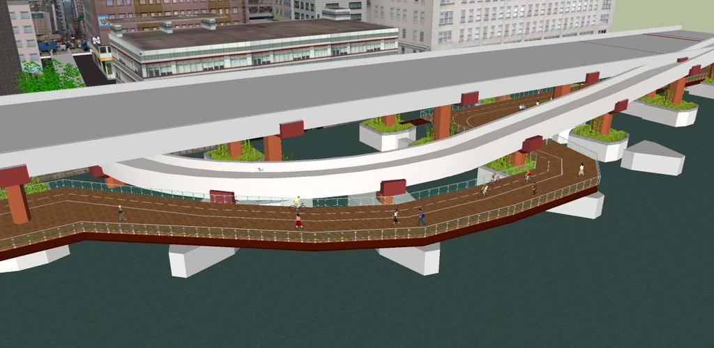
19 Island Eastern Corridor boardwalk Currently: Support columns to the Island Eastern Corridor Future use: 5m wide pedestrian-only boardwalk under IEC, proposed Proposed: Install cycleway adjacent to pedestrian walkway as a part of the boardwalk. Clear distance between piers is approx 9 metres, sufficient for both pedestrian and cycleway use, or alternatively cantilever to use space outside columns. 19 EXISTING STRUCTURE IS 9.7m BETWEEN SUPPORT COLUMNS 9.7m CURRENT IEC BOARDWALK WIDTH IS 5.5m, LEAVING 4.2m AVAILABLE FOR CYCLEWAY 5.5m 4.2m CYCLEWAY


20 20 North Point Harbourfront CYCLISTS DISMOUNT AT PEDESTRIAN INTERSECTIONS WITH FERRY PIERS CONNECTIVITY NORTH POINT FERRY PIERS CYCLEWAY CONTINUES WITH BOARDWALK UNDER IEC CYCLEWAY FOLLOWS IEC BOARDWALK AROUND JUNCTION SLIP ROADS, PER EXISTING PLANS ALTERNATIVE ROUTE ALONG CITY WHARF ROAD WITH MARKED ROUTE AGAINST TRAFFIC NEAR PROVIDENT CENTRE BICYCLE PARKING/HIRE FACILITY CONNECTIVITY NORTH POINT AREA EXISTING ROUTE CYCLISTS CAN USE JAVA ROAD EASTBOUND AND KING S ROAD WESTBOUND BOTH VERY FAST AND BUSY ROADS

21 Tong Shui Road exit Currently: IEC slip road passes outside and under the IEC highway Future use: 5m wide pedestrian-only boardwalk passes around outside of slip road, proposed. (There is insufficient room for the boardwalk to pass under the slip road.) Proposed: The cycleway-boardwalk can also pass around the slip roads, either segregated or with a combined pedestrian/cycleway section. 21 THE BOARDWALK AND CYCLEWAY FOLLOW AROUND THE SLIP ROAD OF THE IEC CYCLEWAY


22 22 North Point Harbourfront CYCLEWAY CONTINUES WITH BOARDWALK UNDER IEC CYCLEWAY FOLLOWS IEC BOARDWALK - THERE IS SUFFICIENT SPACE IN THIS LOCATION FOR THE BOARDWALK TO GO UNDER THE SLIP ROADS CONNECTIVITY TO NORTH POINT EXISTING ROUTE CYCLISTS USE JAVA ROAD EASTBOUND AND KING S ROAD WESTBOUND

23 Man Hong Street exit Currently: IEC slip roads pass under the IEC highway Future use: 5m wide pedestrian-only boardwalk under IEC, proposed Proposed: There is sufficient room under the IEC slip roads to install a combined pedestrian boardwalk and cycleway underneath. 23 MANY POSSIBILITIES EXIST FOR THE IEC BOARDWALK ROUTE CYCLEWAY

24 North Point Hoi Yu St Harbourfront 24 CYCLEWAY CONTINUES WITH BOARDWALK UNDER IEC BICYCLE PARKING/HIRE FACILITY EXISTING ROUTE CYCLISTS USE JAVA ROAD EASTBOUND AND KING S ROAD WESTBOUND ALTERNATIVE ROUTE ALONG HOI CHAK STREET

25 IEC boardwalk to Hoi Yu Street Currently: Support columns to the IEC and a dead-end access road. Future use: 5m wide pedestrian-only boardwalk under IEC, proposed Proposed: use Hoi Yu Street for a short distance before moving onto adjacent unallocated/future park land to install the cycleway. 25 CYCLEWAY
26 Typical Boardwalk Layouts 26 Construction of the boardwalk is feasible using basic design principles. Following are some diagrams showing example layouts of four typical locations: Typical bay Typical bay with close columns Slip roads Pedestrian interfaces at piers
27 Typical Boardwalk Bay m 9.7m Currently planned Pedestrian Boardwalk 4.2m Cycleway 25m approx
28 Typical Boardwalk Bay 28


29 Typical Boardwalk Bay - Completed 29
30 Boardwalk Bay with 5m spaced columns m Pedestrian Boardwalk 4.2m 5.0m Cycleway Boardwalk 25m approx
31 Boardwalk Bay with 5m spaced columns 31 Cantilever boardwalk edge to increase width


32 Boardwalk Bay with 5m spaced columns 32
33 Boardwalk around Tong Shui Slip Road m Currently planned Pedestrian Boardwalk Future Pedestrian Boardwalk Cycleway 25m approx
34 Boardwalk around Tong Shui Slip Road 34 Cantilever boardwalk edge to increase width Slip Road with dimensions Main beams spanning onto adjacent piers

35 Tong Shui Slip Road 35
36 Pedestrian interfaces 36 Sign typical public access to waterfront Give way to pedestrians At intersections with significant pedestrian paths, cyclists must give way to pedestrians Major public access to waterfront At intersections with major pedestrian paths, cyclists must dismount Sign Cyclists dismount
37 IEC Boardwalk-Cycleway Delivers 37 The combination of boardwalk and cycleway not only connects, enables and enlivens the harbourfront, it is also feasible and constructible. With a flexible design, the boardwalkcycleway can be installed, enabling everyone to once again enjoy North Point harbourfront to its fullest.

38 38 Hong Kong Cycling Alliance ( 香港單車同盟 ) is a non-profit organisation that works to make Hong Kong more bicycle-friendly and bicycle-enabled. We advise and support decision-makers about the needs of all kinds of cyclists and about the opportunities for improving Hong Kong through greater support and enablement of cycling. Contact: info@hkcyclingalliance.org
Island Eastern Corridor Boardwalk-Cycleway Feasibility Study
 For discussion on 12 January 2012 Island Eastern Corridor Boardwalk-Cycleway Feasibility Study PURPOSE The purpose of this paper is to understand and promote the feasibility of incorporating the Harbourfront
Harbourfront Commission
 Harbourfront Commission For discussion on 7 September 2011 HC/19/2011 Planning a continuous cycle route along the harbourfront on Hong Kong Island, and Kowloon too PURPOSE This paper is to outline the
Open Space Projects at Kai Tak Harbourfront Area. Harbour Unit 24 February 2017
 Open Space Projects at Kai Tak Harbourfront Area Harbour Unit 24 February 2017 2017 Policy Address - Paragraph 127: There is a general consensus in the community for the need of a new mindset in taking
5.7 Local road upgrades
 5.7 Local road upgrades Local roads around the St Peters interchange and the intersection of Campbell Road and Euston Road would be upgraded to ensure safe and efficient connections with the New M5, and
Port Gamble Shoreline Area Conceptual Trail Proposal
 The North Kitsap Trails Association is pleased to be a partner to the Kitsap Forest and Bay Project and assist Kitsap County, Forterra, Olympic Property Group, Great Peninsula Conservancy and the Port
places Mooloolaba s heart five
 five places the mooloolaba heart 1 Flexible community event use of school oval 2 Enhanced streetscape District cycle route Future cross-block pedestrian link 5 Existing school buildings New signalised
: Activity Room No. 1, G/F, Hong Kong Central Library 66 Causeway Road, Causeway Bay, Hong Kong
 NOTES OF MEETING Meeting Date/ Time : 6 December 2018, 7:00pm 7:30pm Place Project Subject Distribution : Activity Room No. 1, G/F, Hong Kong Central Library 66 Causeway Road, Causeway Bay, Hong Kong :
Pedestrian Safety Review Spadina Avenue
 STAFF REPORT ACTION REQUIRED Pedestrian Safety Review Spadina Avenue Date: October 13, 2015 To: Toronto and East York Community Council From: Director, Transportation Services, Toronto and East York District
STRENGTHENING LOCAL RELATIONSHIPS East Dean & Friston Parish Council Liaison Meeting 7 May 2014 at 10.00am In the Small Hall, East Dean Village Hall
 East Dean & Friston PC Clerk Katrina Larkin Councillor Stephen Shing Councillor Daniel Shing Ian Johnson Principal Traffic and Safety Officer Kevin Morris Highway Steward STRENGTHENING LOCAL RELATIONSHIPS
Concord Road Interchange. Standard hours of work
 Artist impression of the Concord Road interchange, Concord - concept only WestConnex s M4 East will extend the M4 Motorway with two new 5.5 kilometre tunnels from Homebush to Haberfield, providing a bypass
NEWBORO AND PORTLAND HARBOUR REDVELOPMENT PLANS
 INTRODUCTION The Municipal docks in both Newboro and Portland were transferred to the Township of Rideau Lakes by Parks Canada in 2002. Little has been done to improve the docks physical condition or role
JULY OFFICIAL RIDE. 10,000 MILES GUNINESS WORLD RECORD ATTEMPT HONG KONG SECTION 2 ND July, 2017 RIDE DETAILS DISTANCE: 280KM / 174 MILES TOLLS: HK$44
 STARTING POINT HARLEY DAVIDSON OF HONG KONG G/F Eltee Building Ning Foo Street Chai Wan Gather: Ride Briefing Prompt Depart 7:30am 8:00am 8:30am RIDE DETAILS DISTANCE: 280KM / 174 MILES TOLLS: HK$44 We
Report to: Greater Cambridge Partnership Joint Assembly 18 January A10 Foxton level crossing bypass and travel hub
 Report to: Greater Cambridge Partnership Joint Assembly 18 January 2018 Lead officer: Chris Tunstall GCP Director of Transport A10 Foxton level crossing bypass and travel hub 1. Purpose 1.1 The list of
ADVICE ON Cattle Grids
 ADVICE ON 2 Definition A cattle grid, for highway purposes, is a device designed to prevent the passage of animals, or animals of any particular description, but to allow the passage of all or some other
Chapter 4 Route Window NE3 Manor Park station. Transport for London
 Chapter 4 Route Window NE3 Manor Park station MANOR PARK STATION 4 Route Window NE3 Manor Park station 4.7 Highway access to Manor Park station is very good. A117 Station Road connects with A116 to the
YEAR 11 Games - Hiking
 YEAR 11 Games - Hiking As part of the Year 11 PE programme students will take part in a 6 week hiking unit of work during their double PE lesson on a Wednesday morning periods 1 and 2. Students will be
Bravo to Tsing Yi Promenade!
 HBF Newsletter No.14 March 2007 Bravo to Tsing Yi Promenade! 28 March, 2007 International Speaker Luncheon Series VIII - Speaker: Mr. Mark Goh, Head of Marina Bay s Development Agency of the Urban Development
Proposed Bicycle Lanes on Yonge Street from Queens Quay to Front Street
 STAFF REPORT ACTION REQUIRED Proposed Bicycle Lanes on Yonge Street from Queens Quay to Front Street Date: March 12, 2007 To: From: Toronto and East York Community Council Director, Transportation Infrastructure
Construction Staging Adelaide Street West
 REPORT FOR ACTION Construction Staging Adelaide Street West Date: October 6, 2016 To: Toronto and East York Community Council From: Acting Director, Transportation Services, Toronto and East York District
Temporary Uses at the New Central Harbourfront
 For discussion on 21 September 2015 Temporary Uses at the New Harbourfront PURPOSE This paper aims to update Members on the latest progress of the two temporary uses in the new Harbourfront, and seek Members
WPI Research Project - February Designing a Living Victoria Harbour: A Marine User s Perspective
 WPI Research Project - February 2010 Designing a Living Victoria Harbour: A Marine User s Perspective Introduction The following is a progress update of the research of marine use and land/water interfaces
T H E WAT E R F R O NT H O M E S
 THE WATERFRONT HOMES A place you ll truly love to call home With its vibrant future town centre and world class marina, The Waterfront, Shell Cove offers you an unrivalled lifestyle opportunity. Set amidst
Signature Project Scheme in Central & Western District: Harbourfront Enhancement and Revitalisation ( HEAR ) at the Western Wholesale Food Market
 at the Western Wholesale Food Market") For discussion on 7 June 2013 Signature Project Scheme in Central & Western District: Harbourfront Enhancement and Revitalisation ( HEAR ) at the Western Wholesale Food Market PURPOSE This paper seeks
For discussion on 7 June 2013 Signature Project Scheme in Central & Western District: Harbourfront Enhancement and Revitalisation ( HEAR ) at the Western Wholesale Food Market PURPOSE This paper seeks
Road Closure & Traffic Mangement Information during the 2018 ASICS Windermere Marathon Race.
 Road Closure & Traffic Mangement Information during the 2018 ASICS Windermere Marathon Race. This document provides information about the Temporary Traffic Orders & Permits in place for the 2018 events.
Appendix 6 Fulbourn Greenway Review
 Appendix 6 Fulbourn Greenway Review Nigel Brigham & Associates A report for 1 Introduction This report is based on fieldwork carried out in 2016 to review the Greenway network around Cambridge as shown
Major Scheme Business Case Summary Report for Programme Entry
 Paper A Heart of South West Local Transport Board Major Scheme Business Case Summary Report for Programme Entry M5 Junction 25, Taunton July 2016 1 SCHEME SUMMARY Scheme Name M5 Junction 25, Taunton Date
Roundhouse Way Transport Interchange (Part of NATS City Centre Package)
") Roundhouse Way Transport Interchange (Part of NATS City Centre Package) 15/16 16/17 17/18 18/19 19/20 Total TOTAL COST Roundhouse Way Transport Interchange 0.5m 0.5m FUNDING CIL 0.05m 0.05m Growth Deal
Roundhouse Way Transport Interchange (Part of NATS City Centre Package) 15/16 16/17 17/18 18/19 19/20 Total TOTAL COST Roundhouse Way Transport Interchange 0.5m 0.5m FUNDING CIL 0.05m 0.05m Growth Deal
Designing & Building for People on Bikes within evolving constraints Auckland Central City
 Designing & Building for People on Bikes within evolving constraints Auckland Central City Asia Pacific Cycle Congress 19 October 2017 Graeme Bean MEngSc (Transport), BE (Civil), PGDipBus (Mktg), MEngNZ,
Parking Amendments - Bay Street, between Harbour Street and Queens Quay West (York Street, Bay Street, and Yonge Street Ramp Removal)
") REPORT FOR ACTION between Harbour Street and Queens Quay West (York Street, Bay Street, and Yonge Street Ramp Removal) Date: October 26, 2017 To: Toronto and East York Community Council From: Acting Director,
REPORT FOR ACTION between Harbour Street and Queens Quay West (York Street, Bay Street, and Yonge Street Ramp Removal) Date: October 26, 2017 To: Toronto and East York Community Council From: Acting Director,
3. COLTA / HUGA CONNECTIONS - PRELIMINARY
 9 3. COLTA / HUGA CONNECTIONS - PRELIMINARY 3.1 COLTA The Chain of Lakes Trail Association (COLTA) trail, formerly identified as the Chester Spur Line, was completed and opened for use in June 2011. The
Greater Shepparton City Council Planning Scheme Amendment C192 and C193 VicRoads Submission to Traffic Conclave
 Greater Shepparton City Council Planning Scheme Amendment C192 and C193 VicRoads Submission to Traffic Conclave Prepared by: Raelene Stratton Team Leader Integrated Transport and Land Use, North Eastern
Northern Beaches Transport Action Plan
 Northern Beaches Transport Action Plan The NSW Government is taking action now to deliver transport improvements for the Northern Beaches, as well as planning for the future growth of the area. $633 million
HONG KONG OBSERVATION WHEEL AT CENTRAL WATERFRONT. Presented by THE HALL ORGANISATION LTD
 HONG KONG OBSERVATION WHEEL AT CENTRAL WATERFRONT Presented by THE HALL ORGANISATION LTD Hong Kong Central Waterfront The Government Town Planning Board has zoned Central District Area No. 24, a total
The cultural heart of York Central
 The cultural heart of York Central Welcome! Thank you for taking your time to visit our exhibition. 1 We aspire to deliver a complete transformation that would see us become the cultural heart of York
Georgetown-Lewes Rail/Trail Study. Rail/Trail Study: Cool Spring to Cape Henlopen State Park New Road Extension (House Resolution No.
 Georgetown-Lewes Rail/Trail Study Rail/Trail Study: Cool Spring to Cape Henlopen State Park New Road Extension (House Resolution No. 47) August 22, 2011 Presentation Outline Background Benefits Statewide
NOTICE OF REQUIREMENT: NZ TRANSPORT AGENCY: SH6 TARAMAKAU BRIDGE PROJECT
 1 July 2016 Planning Manager Westland District Council 36 Weld Street HOKITIKA Attn Alex Dunn Dear Alex NOTICE OF REQUIREMENT: NZ TRANSPORT AGENCY: SH6 TARAMAKAU BRIDGE PROJECT On 15 June 2016 you issued
CONTENTS. 1 Introduction Always Moving Forward while Building on the Past A Dynamic Destination... 5
 2010 STRUCTURE PLAN - 2 - CONTENTS 1 Introduction... 5 1.1 Always Moving Forward while Building on the Past... 5 1.2 A Dynamic Destination... 5 2 Map A... 6 Exhibition Place and its Neighbours... 7 3 Demonstration
26 th Meeting of Harbour-front Enhancement Committee held at 2:30 pm on 13 May 2009 at 15/F, North Point Government Offices, 333 Java Road, Hong Kong
 26 th Meeting of Harbour-front Enhancement Committee held at 2:30 pm on 13 May 2009 at 15/F, North Point Government Offices, 333 Java Road, Hong Kong Minutes of Meeting Present Prof Lee Chack-fan Prof
Harbour-front Enhancement Committee Sub-committee on Harbour Plan Review
 Harbour-front Enhancement Committee Sub-committee on Harbour Plan Review Fifth Meeting Date: 9 March 2005 Time: 3:00 pm Venue: Conference Room, 15/F, North Point Government Offices 333 Java Road, North
Task Force on Harbourfront Developments on Hong Kong Island
 For discussion on 19 May 2014 Hong Kong Observation Wheel at the New Central Harbourfront PURPOSE This paper outlines a project to develop the Hong Kong Observation Wheel in front of Pier No. 9 and Pier
St. Dennis Drive Conversion of Traffic Lanes to On- Street Parking and Bicycle Lanes
 STAFF REPORT ACTION REQUIRED St. Dennis Drive Conversion of Traffic s to On- Street Parking and Bicycle s Date: April 22, 2014 To: From: Wards: Reference Number: Public Works and Infrastructure Committee
HONG KONG LAND ONLY. Travel Period : 01 Oct 2018 ~ 02 Jan fr. S$400
 HONG KONG LAND ONLY Travel Period : 01 Oct 2018 ~ 02 Jan 2019 fr. S$400 Sheung Shui International Airport Hong Kong Disneyland Tsuen Wan 1 10 3 9 24 Mongkok 11 4 12 18 23 13 Tsim Sha Tsui 19 21 Causeway
Chapter 4 Route window W23 Taplow station. Transport for London
 Chapter 4 Route window W23 Taplow station TAPLOW STATION 4 Route window W23 Taplow station 4.6 Baseline conditions Taplow station Taplow station is located in South Buckinghamshire, 1.5 km southeast of
Part 005 Implementation Strategy _
 Part 0 Implementation Strategy www. landlab.co.nz Queenstown Town Centre Masterplan Version 7 14 June 28 Section 0 Page 4 5.1 Implementation Plan The projects and initiatives contained within the Queenstown
Date: 11 th January, From: Plaistow & Ifold Parish Neighbourhood Plan - Steering Group. Plaistow & Ifold Parish Council
 Date: 11 th January, 2017 From: Plaistow & Ifold Parish Neighbourhood Plan - Steering Group To: Plaistow & Ifold Parish Council Re: Neighbourhood Plan Report to Parish Council Meeting 17 Jan 2017 The Steering
LLANBEDR ACCESS IMPROVEMENTS
 LLANBEDR ACCESS IMPROVEMENTS NON-MOTORISED USER SUPPLEMENTARY REPORT CPF: 5111 Client: Gwynedd Council Document Control Sheet Document Title: Document Author: Project Manager: Project Title: A496 Llanbedr
Paper Reference. Paper Reference(s) 4370/03 London Examinations IGCSE Geography Paper 3. Monday 22 November 2010 Afternoon Time: 1 hour 15 minutes
 4370/03 London Examinations IGCSE Geography Paper 3. Monday 22 November 2010 Afternoon Time: 1 hour 15 minutes") Centre No. Candidate No. Paper Reference 4 3 7 0 0 3 Surname Signature Paper Reference(s) 4370/03 London Examinations IGCSE Geography Paper 3 Monday 22 November 2010 Afternoon Time: 1 hour 15 minutes Initial(s)
Centre No. Candidate No. Paper Reference 4 3 7 0 0 3 Surname Signature Paper Reference(s) 4370/03 London Examinations IGCSE Geography Paper 3 Monday 22 November 2010 Afternoon Time: 1 hour 15 minutes Initial(s)
SOUTHEAST BOULEVARD Planning Study Washington, DC. Progress Drawings October 6, 2014
 Existing Conditions Site Plan CONGRESSIONAL CEMETERY SOUTHEAST BOULEVARD Planning Study Concept A (formerly A-1) Site Plan Concept A (formerly A-1) Concept A proposes an expansion of the Capitol Hill neighborhood
M2 Junction 5. improvements scheme. Preferred route announcement
 M2 Junction 5 improvements scheme Preferred route announcement May 2018 Investing in your roads Why is the scheme needed? At Highways England we believe in a connected country and our network makes these
Downtown Ferry Basin Redevelopment - Stage 1. Integrated Transport Assessment
 Downtown Ferry Basin Redevelopment - Stage 1 Integrated Transport Assessment 12/11/2018 Project: Downtown Ferry Basin Redevelopment - Stage 1 Title: Integrated Transport Assessment Document Reference:
I-10 will close overnight Sunday through Thursday next week. Crews continue to make progress on Sunland s new bridges and ramps.
 NEWS RELEASE a TxDOT Project For immediate release EL PASO DISTRICT Rebecca Reyes (915) 790-4205 Rebecca.Reyes@txdot.gov I-10 will close overnight Sunday through Thursday next week. Crews continue to make
RW Bruhn Bridge and Approaches Project
 RW Bruhn Bridge and Approaches Project The Trans-Canada Highway 1 RW Bruhn Bridge and Approaches Project involves four-laning approximately 1.9 km of Highway 1 in Sicamous, including replacement of the
Minutes of Meeting. Representing Hong Kong Institute of Urban Design. Architects
 10 th Meeting of Harbourfront Commission held at 2:30 pm on 4 June 2012 at the Conference Room on Upper Ground Floor, Hong Kong Heritage Discovery Centre, Kowloon Park, Haiphong Road, Tsim Sha Tsui, Kowloon,
waterview connection Completing the Western Ring Route the Waterview Connection
 waterview connection MAY 2009 Completing the Western Ring Route the Waterview Connection The NZ Transport Agency (NZTA) has a new proposal to complete the Western Ring Route around Auckland by connecting
chapter - Hex Highway Touring Route Hamburg to Strausstown Overview
 chapter - 2 Hex Highway Touring Route Hamburg to Strausstown Overview The on-road Hex Highway automobile and bicycle touring route begins on State Street in downtown Hamburg. The route continues west on
Regional Transport Committee OPEN MINUTES
 Regional Transport Committee OPEN MINUTES Minutes of a meeting of the Regional Transport Committee held in Council Chambers, Waikato Regional Council, 401 Grey Street, Hamilton East on 11 June 2018 at
RESIDENT AND BUSINESS NOTIFICATION TEMPORARY CHANGED TRAFFIC CONDITIONS FINANCIAL REVIEW CORPORATE CYCLING CHALLENGE SUNDAY 04 DECEMBER 2011
 RESIDENT AND BUSINESS NOTIFICATION TEMPORARY CHANGED TRAFFIC CONDITIONS FINANCIAL REVIEW CORPORATE CYCLING CHALLENGE 2011 Dear Resident and Business, The City of Greater Geelong wishes to advise you of
Neighbourhood Committee NDG - Westmount. September 12, 2016
 Neighbourhood Committee NDG - Westmount September 12, 2016 2 Presentation Outline Requests from the committee members Feedback on previous questions Work update and hindrance of the Turcot Project Ministry
Chapter 2 Route window W25 Maidenhead station. Transport for London
 Chapter 2 Route window W25 Maidenhead station MAIDENHEAD STATION 2 Route window W25 Maidenhead station 2.6 The drawings provided at the end of this chapter present the main features of the route window,
Yonge Street / Highway 401 Improvements Update. Public Works and Infrastructure Committee. General Manager, Transportation Services
 PW9.7 STAFF REPORT ACTION REQUIRED Yonge Street / Highway 401 Improvements Update Date: October 26, 2015 To: From: Wards: Reference Number: Public Works and Infrastructure Committee General Manager, Transportation
The Harbour is Hong Kong
 Insert background image Regenerating Hong Kong s Harbour A ULI Advisory Services Program 5 6 October 2005 Hong Kong a sheltered and strategically-located world-class deep-water Regenerating: port and Hong
Texas Department of Transportation Corpus Christi District. Corpus Christi Harbor Bridge
 Texas Department of Transportation Corpus Christi District Corpus Christi Harbor Bridge Presented by Russel W. Lenz, P.E. Corpus Christi District Engineer For 2009 Texas Ports and Waterways Conference
CITY OF NEWCASTLE UPON TYNE JOHN DOBSON STREET AREA. Traffic Regulation (Consolidation) Order 2009 (John Dobson Street Area Variation) Order 2015
 Order 2009 (John Dobson Street Area Variation) Order 2015") CITY OF NEWCASTLE UPON TYNE JOHN DOBSON STREET AREA (I) Traffic Regulation (Consolidation) Order 2009 (John Dobson Street Area Variation) Order 2015 propose to make an Order under Sections 1, 2, 4, 29
CITY OF NEWCASTLE UPON TYNE JOHN DOBSON STREET AREA (I) Traffic Regulation (Consolidation) Order 2009 (John Dobson Street Area Variation) Order 2015 propose to make an Order under Sections 1, 2, 4, 29
Maidenhead Bridge. Proposed Work
 W1.1 Maidenhead Bridge Proposed Work The Maidenhead Bridge over the River Thames at Maidenhead is a Grade II* listed structure. Installation of overhead electrification on top of the structure would be
Whether travelling on two wheels or two feet, we help communities stay active and sustainable.
 Creating pathways Whether travelling on two wheels or two feet, we help communities stay active and sustainable. Stantec is a local leader in providing cycleway expertise to clients throughout New Zealand.
SOUTH GLOS COUNCIL UPDATE FOR SUSCOM - JANUARY 2016
 SOUTH GLOS COUNCIL UPDATE FOR SUSCOM - JANUARY 2016 Go Ultra Low City Bid Success Announced on Monday 25 January, the Department for Transport (DfT) allocated 7M to the four West of England authorities
"TOUCAN" - An unsegregated crossing for pedestrians and cyclists
 Traffic Advisory Leaflet 10/93 August 1993 "TOUCAN" - An unsegregated crossing for pedestrians and cyclists Summary This leaflet gives advice on the design and use of the Toucan signal controlled crossing,
FEASIBILITY CRITERIA
 This chapter describes the methodology and criteria used to evaluate the feasibility of developing trails throughout the study areas. Land availability, habitat sensitivity, roadway crossings and on-street
Chapter 8 Route Window NE7 Chadwell Heath station. Transport for London
 Chapter 8 Route Window NE7 Chadwell Heath station Transport CHADWELL HEATH STATION 8 Route Window NE7 Chadwell Heath station Baseline conditions 8.6 This route window lies within the London Boroughs of
epods Airline Management Educational Game
 epods Airline Management Educational Game Dr. Peter P. Belobaba 16.75J/1.234J Airline Management March 1, 2006 1 Evolution of PODS Developed by Boeing in early 1990s Simulate passenger choice of airline/paths
High Speed Two: From Crewe to Manchester, West Midlands to Leeds and beyond
 High Speed Two: From Crewe to Manchester, West Midlands to Leeds and beyond Phase 2b Route Decision Moving Britain Ahead July 2017 September 2016 High Speed Two: From Crewe to Manchester, West Midlands
Chapter 6 Route Window NE5 Seven Kings station. Transport for London
 Chapter 6 Route Window NE5 Seven Kings station Transport SEVEN KINGS STATION 6 Route Window NE5 Seven Kings Station Transport Introduction 6.1 All construction activities in this route window are associated
Explore the Bay the Green Way
 Explore the Bay the Green Way Botany Bay Trail Pre-Feasibility Study Report Nick Benson Sutherland Shire Environment Centre August 2002 1 Botany Bay Trail Explore the Bay the Green Way Opportunities for
Dufferin Jog Elimination Project
 Project Project Status Update November 14 2007 Project History Planning Alternatives Criteria Measured Project Benefits Structural Configurations Considered Structural Design Considerations The Preferred
Abbey Chesterton bridge Questions & Answers
 Abbey Chesterton bridge Questions & Answers Please click on links below to go to individual subjects: Bridge location and access routes Timescales Bridge details and accessibility Construction compound
HONG KONG LAND ONLY. Travel Period : 01 Oct 2018 ~ 02 Jan fr. S$150
 HONG KONG LAND ONLY Travel Period : 01 Oct 2018 ~ 02 Jan 2019 fr. S$150 Sheung Shui International Airport Hong Kong Disneyland Tsuen Wan 1 10 3 9 24 Mongkok 11 4 12 18 23 13 Tsim Sha Tsui 19 21 Causeway
Fast Lanes Study Phase III Telephone Survey Results
 Fast Lanes Study Phase III Telephone Survey Results Methodology 2012 Fast Lanes Study 6/7/12 2 194,000 196,000 651,000 Adults (18+) 261,000 Methodology Areas in Mecklenburg & Union Counties defined by
Bus Routes and Costs
 Bus Routes and Areas Bus Route Time Stop No. Bus Stops () Time Stop No. Bus Stops () 6:50 1 Marinella (Junction at Welfare Rd/ Nam Long Shan 15:55 1 Marinella (Junction at Welfare Rd/ Nam Long Shan Aberdeen
To: From: Plans showing the alignments of the routes discussed in this section are presented in Appendix A.
 Project: Cambourne to Cambridge Better Bus Journeys To: CCC Subject: Considerations for Corridor Option Plans From: Atkins Date: 1 Sep 2016 cc: 1. Introduction This note summarises considerations undertaken
A Review on the Recent Large Scale Infrastructure Projects in Hong Kong
 A Review on the Recent Large Scale Infrastructure Projects in Hong Kong Part I A general understand and Review of the scope and nature of Infrastructure Developments in Hong Kong 1 General Classification
Gold Coast. Rapid Transit. Chapter content. Chapter four Route selection and staging
 Chapter four Route selection and staging Gold Coast Rapid Transit Chapter four Route selection and staging Chapter content Route selection...73 Section one: Helensvale to Griffith University...74 Section
Public Event Day. 1. Community visioning 2. Street activation 3. Interactive feedback 4. Survey questionnaire and social media feedback
 Project Background Four Big Ideas. The Healthy Thriving Place. An International Focus. Reclaiming Mooloolaba. The Resort Heart of the Coast In November a big ideas workshop was held involving members from
A63 Castle Street, Hull HullBID Network Lunch 24 August 2017
 A63 Castle Street, Hull HullBID Network Lunch 24 August 2017 James D Leeming Senior Project Manager What we will cover today? Introduction to Highways England and the Road Investment Strategy A63 Scheme
SOUTHBOUND YONGE STREET TO EASTBOUND HIGHWAY 401 F L Y -UNDER
 SOUTHBOUND YONGE STREET TO EASTBOUND HIGHWAY 401 F L Y -UNDER Proposal to Eliminate Traffic Gridlock in South North York Centre Area With Southbound Yonge Street to Eastbound Highway 401 Fly-UNDER A much
ACORNS PROJECTS LIMITED
 ACORNS PROJECTS LIMITED A4 London Road, M4 J5 to Sutton Lane, Slough, Berkshire Combined Stage 1 and 2 Road Safety Audit For Slough Borough Council Prepared by Acorns Projects Limited Safety Traffic Project
BILLY BISHOP TORONTO CITY AIRPORT 2018 MASTER PLAN UPDATE
 BILLY BISHOP TORONTO CITY AIRPORT 2018 MASTER PLAN UPDATE City of Toronto Local Issues & Initiatives Bryan Bowen City Planning Waterfront Secretariat June 25, 2018 PRESENTATION OUTLINE BACKGROUND: ISSUES
Presentation to The HK Institute of Certified Public Accountants. New Railways to Sustain Hong Kong s Momentum
 Presentation to The HK Institute of Certified Public Accountants New Railways to Sustain Hong Kong s Momentum Stephen Chik Head of Project Engineering 26 February 2014 MTR Corporation 28/02/2014 Page 1
Wellington $312 $49 $456 OVERVIEW WELLINGTON REGIONAL SUMMARY
 National Land Transport Programme 2015 18 Wellington WELLINGTON REGIONAL SUMMARY OVERVIEW The Wellington region is made up of a number of cities, urban areas and supporting rural hinterland. The city is
Busway between West Cambourne site and the junction of the A1303 / A428
 Project: A428 To: CCC Subject: Routes From: Atkins Date: 14 April 2016 cc: This note summarises the policy references to a bus link between Cambourne and Cambridge, in particular references to the route
State Road Upgrades Southern Region
 State Road Upgrades Southern Region A MAJORITY LIBERAL GOVERNMENT WILL: Undertake an historic reset of roads and traffic management in Southern Tasmania taking roads to the next level. Underpin the extraordinary
Berkshire Local Transport Body. Pro- forma for Consideration of a Transport Scheme at Programme Entry Stage. Section 1: Headline Description
 Berkshire Local Transport Body Pro- forma for Consideration of a Transport Scheme at Programme Entry Stage Section 1: Headline Description Local Authority Royal Borough of Windsor and Maidenhead Number
Seek the Board s approval for the Donald Place kerb and channel renewal to progress to final design, tender and construction; and
 3. DONALD PLACE - KERB AND CHANNEL RENEWAL General Manager responsible: General Manager City Environment Officer responsible: Transport and City Streets Manager Author: Michelle Flanagan, Streets Capital
WEEKLY PROVINCIAL HIGHWAY CONSTRUCTION UPDATE FOR THURSDAY, OCTOBER 6, 2016 The law is black and white. Slow to 60 km/hr in Work Zones.
 NEW WORK PROJECT/WORK: Highway 354 near Dilke ESTIMATED COST: $3.4M START OF THIS YEAR'S CONSTRUCTION: October 1, 2016 DESCRIPTION: About 17 km of surfacing on Highway 354 from the junction with Highway
Centurion Way Chichester
 Centurion Way Chichester Work book of plans to show details of the Centurion Way, its links, and potential developments and enhancements from linking to the South Downs National Park all the way to the
Topic on A Technical and Project Review of the 10 Airport Core Projects and their Influence on Current Developments
 Topic on A Technical and Project Review of the 10 Airport Core Projects and their Influence on Current Developments Presented by Raymond Wong City University of Hong Kong The need of a new Airport The
Armstrong Creek Horseshoe Bend Precinct Traffic Impact Assessment
 ` Armstrong Creek Horseshoe Bend Precinct Job Number: CG111786 Cardno Victoria Pty Ltd ABN 47 106 610 913 150 Oxford Street, Collingwood Victoria 3066 Australia Telephone: 03 8415 7777 Facsimile: 03 8415
M56. New Junction 11a Summary of the consultation report
 M56 New Junction 11a Summary of the consultation report August 2017 M56 New Junction 11a Summary of the public consultation The scheme The M56 New Junction 11a scheme is part of our continued programme
Update Report - Etobicoke Creek and South Mimico Creek Trails
 REPORT FOR ACTION Update Report - Etobicoke Creek and South Mimico Creek Trails Date: October 23, 2017 To: Etobicoke York Community Council From: General Manager, Parks Forestry and Recreation Wards: Ward
Route 29 Solutions Projects
 Your guide to the Route 29 Solutions Projects For full details & continued engagement please visit www.route29solutions.org The Route 29 Solutions Package is a $230 million investment into the improvement
LHNCC 144/9 Commercial Street Edinburgh EH6 6LB. Mob: March 2018
 LHNCC 144/9 Commercial Street Edinburgh EH6 6LB Mob: 07810735518 e-mail: secretary@lhncc.org.uk 28 March 2018 David Leslie Head of Planning and Transport, PLACE, Waverley Court, 4 East Market Street, Edinburgh,