LLANBEDR ACCESS IMPROVEMENTS
|
|
|
- Clyde Hancock
- 5 years ago
- Views:
Transcription
1 LLANBEDR ACCESS IMPROVEMENTS NON-MOTORISED USER SUPPLEMENTARY REPORT CPF: 5111 Client: Gwynedd Council
2 Document Control Sheet Document Title: Document Author: Project Manager: Project Title: A496 Llanbedr Acces Improvements Non Motorised User Supplementary Report Dylan Roberts Dylan Parry A496 Llanbedr Acces Improvements Revision History Date Version No. Summary of Changes 02/12/ n/a 20/12/ n/a Approved Approved by Signature Date Version Dylan Parry Dylan Parry 02/12/ Dylan Parry Dylan Parry 20/12/ Distribution Name Title Date Version 2016 Gwynedd Council / YGC. All Rights Reserved. Copyright in any or all of this documentation belongs to Gwynedd Council / YGC of Council Offices, Shirehall Street, Caernarfon, Gwynedd, LL55 1SH (the 'Owner') and may not be used, sold, transferred, copied or reproduced in whole or in part, in any manner of form or on any media to any person other than in accordance with the terms of the Owner's agreement or otherwise without the prior written consent of the Owner. ISO9001:2008 FS ISO14001:2004 EMS OHSAS18001:2007 OHS

3 1. INTRODUCTION 1.1 The purpose of this report is to expand and develop on the main objectives identified in the Non-Motorised Users (NMU) Audit. An NMU audit has been undertaken in accordance with document HD42/5 in Volume 5 of the Design Manual for Roads and Bridges. NMUs are considered to be pedestrians, cyclists and equestrians. 2. NMU AUDIT OBJECTIVES 2.1 The six main objectives identified in the NMU Audit are;- a) NMU Objective 1 - Enhance NMU provisions along the length of Mochras Road affected by the proposed improvement. b) NMU Objective 2 - Remove potential interface between users of PRoW 1 (Public Rights of Way) and the traffic along the new road. c) NMU Objective 3 - Maintain access to PRoW s 1 and 43 from Mochras Road during construction and operation and maintain the Wales Coastal Path affected by the works. d) NMU Objective 4 - Maintain access to PRoW s 87 and 30 (Llanfair) from the A496 during construction and operation. e) NMU Objective 5 - Investigate further NMU enhancements within Llanbedr village and along Mochras Road between Llanbedr and the tie in with the proposed improvement. f) NMU Objective 6 - Investigate the possibility of improving pedestrian access towards the Neolithic Standing Stones. Location Plan Hawlfraint y Goron a hawliau cronfa ddata 2016 Arolwg Ordnans Cyngor Gwynedd 2
4 3. NMU Objective 1: Enhance NMU Provisions along Mochras Road affected by the proposed improvement. Existing Situation 3.1 The existing section of the Class 3 Mochras Road between Llanbedr Train Station up to the existing car park, a length of approximately 325m, will be affected by the proposed improvement. Pedestrian Improvement Recommendation 3.2 A new 2.0m footway will be constructed alongside the realigned Class 3 Mochras Road from Llanbedr Railway Station up to the existing car park as part of the improvement. A draft plan showing the proposal is included in Appendix A of this document. Cyclists Improvement Recommendation 3.3 The new Class 3 Mochras Road at 7.3m width will be wider than the current carriageway. Road users will also have improved visibility along this new section. The realigned Class 3 Road will go underneath the proposed A496. Cyclists travelling to the village centre therefore have the option to avoid the new A496/Class 3 Mochras junction, unless they want to join the A496. Equestrian Improvement Recommendation 3.4 Equestrians will benefit from the improved carriageway width, alignment and improved visibility. Access to PRoW 43 (Bridleway) will be maintained to and from the realigned Class 3 Mochras Road at all times. 3
5 4. NMU Objective 2: Remove potential interface between users of PRoW 1 (Public Rights of Way) and the traffic along the new road. Existing Situation 4.1 Currently Public Right of Way (PRoW) 1 (Footpath) is not intersected by the existing A496 carriageway. Pedestrian Improvement Recommendation 3.5 The proposed road will intersect PRoW 1 to the north west of the village. It is proposed that a new underpass will be constructed to the north of the intersection. This will serve as both an inter-field access for the landowner and as a new underpass for the PRoW. A public path order will be required to divert the PRoW. A draft plan showing the proposal is included in Appendix A of this document. Cyclists Improvement Recommendation 4.2 As this is a footpath, cyclists are not affected. Equestrian Improvement Recommendation 4.3 As this is a footpath, equestrians are not affected. 4
6 5. NMU Objective 3: Maintain access to PRoW s 1 and 43 from Mochras Road during construction and operation and maintain the Wales Coastal Path affected by the works. Existing Situation 5.1 PRoW 1 (Footpath) and PRoW 43 (Bridleway) connect to the existing Class 3 Mochras Road. Pedestrian Improvement Recommendation 5.2 Maintaining access to both PRoW s will be included as a contractual condition in the construction contract. Safe access will be maintained at all times during the construction period. Full access will be available during the operation period. Cyclists Improvement Recommendation 5.3 Maintaining access to PRoW 43 (Bridleway) will be included as a contractual condition in the construction contract. Safe access will be maintained at all times during the construction period. Full access will be available during the operation period. Equestrian Improvement Recommendation 5.4 Maintaining access to PRoW 43 (Bridleway) will be included as a contractual condition in the construction contract. Safe access will be maintained at all times during the construction period. Full access will be available during the operation period. 5
7 6. NMU Objective 4: Maintain access to PRoW s 87 and 30 (Llanfair) from the A496 during construction and operation. Existing Situation 6.1 PRoW 87 (Footpath) and PRoW 30 Llanfair (Bridleway) connect to the existing A496 Road to the north of the village. See draft plan in Appendix A. Pedestrian Improvement Recommendation 6.2 Maintaining access to both PRoW s will be included as a contractual condition in the construction contract. Safe access will therefore be maintained at all times during the construction period. Full access will be available during the operation period. Cyclists Improvement Recommendation 6.3 As these are footpaths, cyclists are not affected. Equestrian Improvement Recommendation 6.4 As these are footpaths, equestrians are not affected. 6
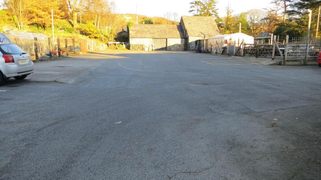
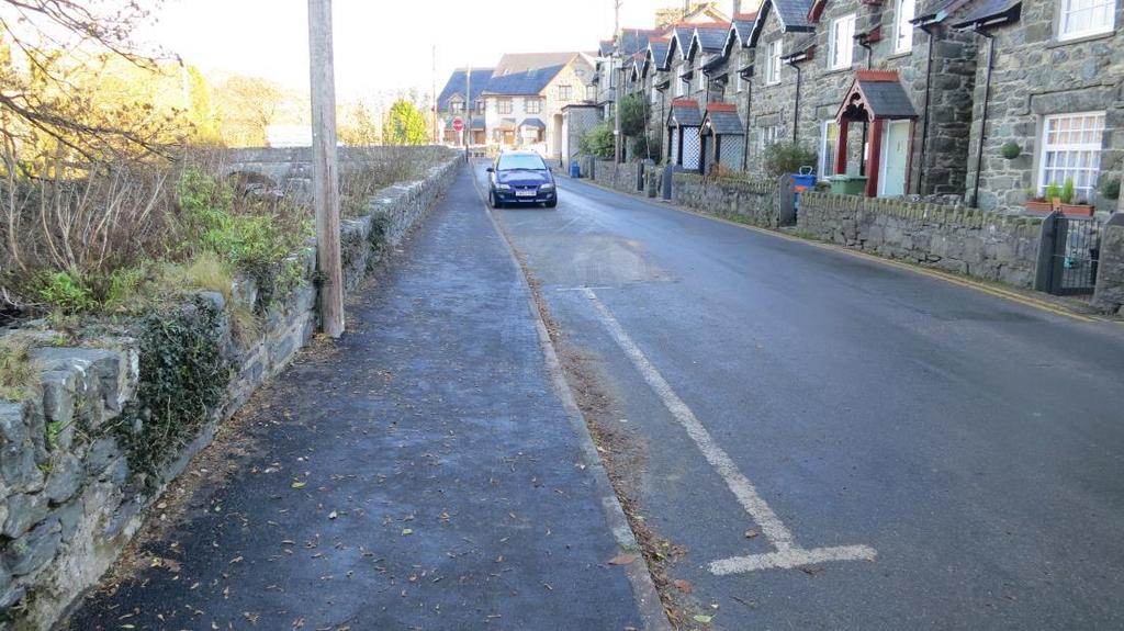
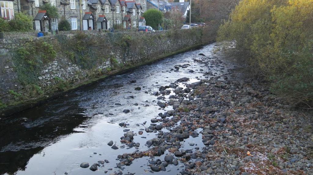
8 7. NMU Objective 5: Investigate further NMU enhancements within (a) Llanbedr village and along (b) Mochras Road between Llanbedr and the tie in with the proposed improvement. 7a Llanbedr Village Enhancements Existing Situation 7.1 There are currently six commercial premises close to the village centre, namely the Village Shop, Tea Rooms, Hair and Beauty Salon, Bike shop, Charity Shop and a Public House. 7.2 The width of the carriageway through Llanbedr Village is narrow compared to current design standards. It has an average width of 5.5m. Due to the proximity of the existing properties there is no opportunity to widen the carriageway or to construct a new footway within the village centre. 7.3 Following completion of the Llanbedr Access Road it is forecasted that the volume of traffic going through Llanbedr will reduce by 90% to 316 vehicles per day. 7.4 On street parking is currently permitted along the northbound carriageway. There is also a 48 space private car park to the rear of the Hair and Beauty Salon, Charity Shop and Bike Shop which is owned by the Victoria Inn Public House and is located just off the village centre. Parking is also permitted along the eastern carriageway on the Class 3 Road towards Llanbedr Primary School. 7.5 Existing footways provision is limited within the village centre. There is a 355m long footway along the Class 3 road to the east of the village centre towards the Primary School. There is a 165m long footway along the Class 3 Mochras Road. There are also short length of footways in front of the Tea Room, Hair and Beauty Salon, new housing to the south of Pont Llanbedr and a narrow footway over Pont Llanbedr. 7.6 Lon Las Cymru passes through the centre of Llanbedr, entering the village from the south east along the Class 3 road near Ty Capel and leaves the village along another Class 3 road past Ty Mawr Hotel. Sustrans have also designated the Class 3 Mochras Road as a Local Route. 7.7 No other designated footpaths or bridleways will be affected by the scheme except for those previously identified. 7.8 A plan showing the current provisions is included in Appendix B. Pedestrian Improvement Recommendation 7.9 Due to the narrowness of the existing highway within Llanbedr, there is no opportunity to enhance or to provide a new footway along the current A496. A footway already exists along the Class 3 road from the village centre towards the Primary School and partly along the Class 3 Road Mochras towards Shell Island. 7
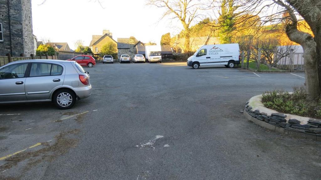
9 Cyclists Improvement Recommendation 7.10 Following the construction of the access road, the volume of traffic will be reduced by 90% in the village centre to 316 vehicles per day. Reduced traffic volumes will make cycling more attractive. It is recommended to investigate the feasibility of providing secure bike stands within the village centre during the detailed design stage Equestrian Improvement Recommendation 7.11 There are no current equestrian facilities within the village centre and no additional provision is proposed. However equestrians will benefit from reduced traffic volumes within the village centre. Car Parking Provision 7.12 Current parking provisions within the village centre are considered sufficient. Parking for the Newsagent and Tea Rooms would be considered short term on the road in front of the properties. The Cycle Shop, Charity Shop, Hair and Beauty Salon and Public House have access to the 48 space private car park just off the village centre (see photograph 1 and 2 in Appendix D). It is recommended to investigate the feasibility of providing dedicated roadside parking bays on the current A496 during the detailed design stage. 7b Mochras Road Improvements Existing Situation 7.13 Figures 1 to 3 in Appendix C shows the current layout and constraints along the Class 3 Mochras Road The total length of the Class 3 Mochras Road from its junction with the A496 up to the private road to Shell Island Campsite is 2.2km. There is an existing footway from its junction with the A496 for a length of 165m. The footway terminates opposite the property known as the Glyn. The footway is retained by a 2.2m high retaining wall above the river. This section is shown in Figure 1 in Appendix C. The footway is shown in Photograph 3 and the retaining wall in shown in Photograph 4 in Appendix D. The width of the carriageway adjacent to the existing footway is generally 5.5m Between the Glyn property and the existing car park where footpath 1 commences, there is no footway. This section is shown in Figure 2 in Appendix C. The carriageway width is generally just less than 5m but widens to just over 5.5m on the curve before the car park. There is a 1.7m high, 105m long retaining wall along this section which retains the road above the river. This section is shown in Photograph 5 and Photograph 6 in Appendix D. The proposed improvement will 8
10 cross over the existing Mochras Road just east of the existing car park on the Class 3 Mochras Road. (See draft plan in Appendix A) Between the existing car park and the Llanbedr Railway Station, there is an offline footway that has recently been constructed. The width of the carriageway in this area is generally narrow at 4.5m. This section is shown in Figure 3 in Appendix C and the footway is shown in Photograph No 7 in Appendix D. This section of the Class 3 Mochras Road will be realigned as part of the improvement works and a new 2.0m wide footway will be constructed adjacent to the new carriageway. Pedestrian Improvement Recommendation 7.17 The Class 3 Mochras Road serves as a link between Llanbedr Village, Llanbedr Train Station and further afield to Llanbedr Airfield and Shell Island Campsite. It is understood that the extent of the scheme is up to the Railway Station and therefore pedestrian consideration further along to Llanbedr Airfield and Shell Island is not considered further in this report. Connect Footway between Glyn property and new Mochras Road Section Between the Glyn and the Lismore properties, it is recommended that a new footway is constructed within the existing verge, between the existing road and river. To do this will require constructing a short length of new retaining wall to adjoin the existing retaining wall in front of the Glyn. It will also require tree felling within this area and the moving of statutory undertaker s apparatus. The feasibility of removing these trees has not been investigated as part of this report. Should there be any issues with removing them, then localised re-alignment of the footway around the trees should be considered. The existing verge is shown in Photographs 8 and 9 in Appendix D There is an existing retaining wall opposite the access to Lismore for a length of 110m, which retains the road above the river. It is not possible to construct a footway along this length without diverting the river or purchasing parts of the gardens of Lismore and Swn yr Afon. Two options should be considered for this area. The first option would be to provide adequate signage for motorists forewarning of pedestrians in the road and signage to warn pedestrians that there is no footway for a short section. A second option to consider would be to narrow the carriageway and introduce a new footway/priority system over a 50m length and to then cross the footway over the road into the field to the north-west of Swn yr Afon. The footway would then follow the line of the existing road and within the field until it crosses back over the road to join the new footway near the existing car park. This draft alignment is shown in Figure 2 in Appendix C The section between the existing car park and Llanbedr Railway Station will be improved as part of the proposed scheme and is not considered further in this report. 9
11 Cyclists Improvement Recommendation 7.21 Apart from an improved alignment and width as stated in NMU Objective 1, no further improvements are proposed. Equestrian Improvement Recommendation 7.22 Apart from an improved alignment and width as stated in NMU Objective 1, no further improvements are proposed. 10
12 8. NMU Objective 6: Investigate the possibility of improving pedestrian access towards the Neolithic Standing Stones. Neolithic Standing Stones - Existing Situation 8.1 There is currently no public right of way to the Neolithic standing stones. Neolithic Standing Stones - Recommendation 8.2 It is recommended that a new footpath is created from the existing A496 to allow for access to the standing stones. 8.3 At the time of this report the number of visitors to the standing stones is unknown and therefore no additional parking provision is proposed. 11
13 APPENDIX A 12
 Proposed Footpath Diversion PROW 1")


14 CLEIENT/CLIENT : 96 h A4 rlec Ha NODIADAU/NOTES PROW 87 PROW 30 (Llanfair) Proposed Footpath Diversion PROW 1 PROW 1 Class 3 Mochras Road Llanbedr Standing Stones CYNGOR GWYNEDD COUNCIL f y o r a d d d s CYNLLUN / SCHEME : A496 Barnmouth TEITL LLUNIAD / DRAWING TITLE : DARLUNWYD GAN : DYDDIAD DARLUNWYD : DRAWN BY : DATE DRAWN : GWIRIWYD GAN : DYDDIAD GWIRIWYD : CHECKED BY : DATE CHECKED : Taflen o GRADDFEYDD : Sheet of SCALES : Rhif Lluniad Drawing No. CYWI REV 02/12/ :14:12 F R GWIRIWYD CHECKED NEWIDIADAU MODIFICATIONS \\YGC.GWYNEDD.GOV.UK@SSL\DAVWWWROOT\PD\R3\5111\0_CDP - COMPUTER DESIGN PROGRAMS\AUTOCAD\GA\5111_GA FOOTPATH.DWG RHIF NO. GAN BY DYDDIAD DATE PROW 43
15 APPENDIX B 13

16 Existing private car park (48 spaces) NCN 8 On street parking & limited footways On street parking & footway adjacent to the road Village Centre On street parking & footway adjacent to the road
17 APPENDIX C 14


18 Existing Footway along the Class 3 Mochras Road. Existing Car Park Proposed new footway along Class 3 Mochras Road. New priority System / Crossover into field 15

19 Class 3 Mochras Road to be realigned as part of the improvement scheme. New footway to be constructed adjacent to the road. Existing Car Park 16
20 APPENDIX D 17
21 Photograph 1 Photograph 2 18
22 Photograph 3 Photograph 4 19
23 Photograph 5 Photograph 6 20
24 Photograph 7 Photograph 8 21
25 Photograph 9 22
SNOWDONIA ENTERPRISE ZONE
 CPF 4614: Snowdonia Enterprise Zone: Llanbedr Access Improvements SNOWDONIA ENTERPRISE ZONE LLANBEDR ACCESS IMPROVEMENTS WELTAG STUDY PLANNING STAGE AND APPRAISAL (STAGE 1) REPORT CPF: 4614 Client: Gwynedd
ACORNS PROJECTS LIMITED
 ACORNS PROJECTS LIMITED A4 London Road, M4 J5 to Sutton Lane, Slough, Berkshire Combined Stage 1 and 2 Road Safety Audit For Slough Borough Council Prepared by Acorns Projects Limited Safety Traffic Project
Donegal County Council
 Donegal County Council Roads & Transportation Directorate PLANNING AND DEVELOPMENT REGULATIONS 2001 (as amended) Nature and Extent of proposed development in accordance with Part 8 requirements of the
Queen s Circus Roundabout
 Stage 2 Road Safety Audit Ref: 1128-RSA-01 Prepared for: Steer Davies Gleave By: Capital Traffic Prepared by: Checked by: Approved by: Andy Haunton, Audit Team Leader Jonathan Thompson, Audit Team Member
Appendix C Stage 1 Road Safety Audit
 Monaghan County Council N2 Monaghan Town to Emyvale Road Improvements Part 8 Application Description of Proposed Development Appendix C Stage 1 Road Safety Audit Draft 1 11 April 2013 \\DUBNTS03\DUBLIN_JOBS\218000\218692-00\4.
Appendix 8 Sawston Greenway Review
 Appendix 8 Sawston Greenway Review Nigel Brigham & Associates A report for 1 Introduction This report is based on fieldwork carried out in 2016 to review the Greenway network around Cambridge as shown
London Borough of Barnet Traffic & Development Design Team
 London Borough of Barnet Traffic & Development Design Team AERODROME ROAD PEDESTRIAN FACILITY AND BUS STOP INTRODUCTION FEASIBILITY REPORT Job Number: 60668 Doc Ref: S106/12-13/60668 Author: Manoj Kalair
Appendix 9 Melbourn Greenway Review
 Appendix 9 Melbourn Greenway Review Nigel Brigham & Associates A report for 1 Introduction This report is based on fieldwork carried out in 2016 to review the Greenway network around Cambridge as shown
Centurion Way Chichester
 Centurion Way Chichester Work book of plans to show details of the Centurion Way, its links, and potential developments and enhancements from linking to the South Downs National Park all the way to the
Appendix 6 Fulbourn Greenway Review
 Appendix 6 Fulbourn Greenway Review Nigel Brigham & Associates A report for 1 Introduction This report is based on fieldwork carried out in 2016 to review the Greenway network around Cambridge as shown
Report to: Greater Cambridge Partnership Joint Assembly 18 January A10 Foxton level crossing bypass and travel hub
 Report to: Greater Cambridge Partnership Joint Assembly 18 January 2018 Lead officer: Chris Tunstall GCP Director of Transport A10 Foxton level crossing bypass and travel hub 1. Purpose 1.1 The list of
ADVICE ON Cattle Grids
 ADVICE ON 2 Definition A cattle grid, for highway purposes, is a device designed to prevent the passage of animals, or animals of any particular description, but to allow the passage of all or some other
Unlocking our Coastal Heritage Strand 2 - Watermouth Bay, nr Ilfracombe
 Unlocking our Coastal Heritage Strand 2 - Watermouth Bay, nr Ilfracombe In order to provide a safe route for users of the South West Coast Path this project realigned 265m of the A399 coast road to incorporate
L L A N B E D R A C C E S S I M P R O V E M E N TS
 CPF 4614: Snowdonia Enterprise Zone: Llanbedr Access S N OWDONIA ENTERPRISE ZO N E L L A N B E D R A C C E S S I M P R O V E M E N TS WELTAG STUDY: PLANNING STAGE CPF: 4614 Client: Gwynedd Council Planning
Kent Pedestrian Guard Railing Assessment
 Kent Pedestrian Guard Railing Assessment Canterbury Final Report for JTB March 2012 Project Number B1649000 Jacobs Eng UK Ltd, Miller House, Lower Stone Street, Maidstone, Kent ME15 6GB Document control
Kent Pedestrian Guard Railing Assessment
 Kent Pedestrian Guard Railing Assessment Canterbury - Consultation Report November 2010 Project Number B1555300 Jacobs Eng UK Ltd, Miller House, Lower Stone Street, Maidstone, Kent ME15 6GB Document control
To: From: Plans showing the alignments of the routes discussed in this section are presented in Appendix A.
 Project: Cambourne to Cambridge Better Bus Journeys To: CCC Subject: Considerations for Corridor Option Plans From: Atkins Date: 1 Sep 2016 cc: 1. Introduction This note summarises considerations undertaken
5.7 Local road upgrades
 5.7 Local road upgrades Local roads around the St Peters interchange and the intersection of Campbell Road and Euston Road would be upgraded to ensure safe and efficient connections with the New M5, and
1.2 If the Council is satisfied that traffic on a road should be prohibited for the purpose of:
 APPENDIX 2 POLICY/PROCEDURE IN REGARD TO TEMPORARY ROAD CLOSURES ON THE COUNTY ROAD NETWORK FOR EVENTS ON O'R NEAR THE HIGHWAY. (Not in respect of a footpath, bridleway, cycle track or byway) 1.0 INTRODUCTION
Business Case Approved. Under Construction. Business Case Approved. Under Construction
 Item 6 Appendix A: LGF Project Summary for South Essex Update September Project and A127 Network Resilience (Essex) Basildon Integrated Transport Package (Essex) Range of improvements at key locations
THE WELSH MINISTERS STATEMENT OF REASONS
 THE WELSH MINISTERS The Welsh Ministers (The M4 Motorway (Junction 23 (East of Magor) to West of Junction 29 (Castleton) and Connecting Roads) and The M48 Motorway (Junction 23 (East of Magor) Connecting
All reports. 1. Governance Service receive draft report Name of GSO DPR
 DELEGATED POWERS REPORT NO. SUBJECT: Redevelopment at Grahame Park Estate, NW9, Phase 1B Sub-phase 1 Highways Agreement under Sections 38 and 278 of the Highways Act 1980. Control sheet All of the following
Major Scheme Business Case Summary Report for Programme Entry
 Paper A Heart of South West Local Transport Board Major Scheme Business Case Summary Report for Programme Entry M5 Junction 25, Taunton July 2016 1 SCHEME SUMMARY Scheme Name M5 Junction 25, Taunton Date
Commissioning Director - Environment
 Finchley and Golders Green Area Committee 27 April 2017 Title Report of Wards Status Urgent Key Enclosures Summers Lane,N12 Request for Pedestrian Improvements Commissioning Director - Environment Woodhouse
MEMORANDUM OF UNDERSTANDING WITH BUSINESS IMPROVEMENT DISTRICTS WITHIN BIRMINGHAM
 MEMORANDUM OF UNDERSTANDING WITH BUSINESS IMPROVEMENT DISTRICTS WITHIN BIRMINGHAM For services in respect of: Highway Maintenance and Management Car Parking Traffic Management Signatories: For Birmingham
Longmont to Boulder Regional Trail Jay Road Connection DRAFT FINAL REPORT
 Longmont to Boulder Regional Trail Jay Road Connection DRAFT FINAL REPORT December 2018 Project Summary Boulder County, Colorado, in partnership with the City of Boulder, is evaluating options for multi-use
Seek the Board s approval for the Donald Place kerb and channel renewal to progress to final design, tender and construction; and
 3. DONALD PLACE - KERB AND CHANNEL RENEWAL General Manager responsible: General Manager City Environment Officer responsible: Transport and City Streets Manager Author: Michelle Flanagan, Streets Capital
IOW Ramblers Submission Paper to the Sept 2016 ROW Improvement Plan Consultation.
 IOW Ramblers Submission Paper to the Sept 2016 ROW Improvement Plan Consultation. The current Island Rights of Way Improvement Plan is a comprehensive document and much of its content is still relevant
NOTICE OF REQUIREMENT: NZ TRANSPORT AGENCY: SH6 TARAMAKAU BRIDGE PROJECT
 1 July 2016 Planning Manager Westland District Council 36 Weld Street HOKITIKA Attn Alex Dunn Dear Alex NOTICE OF REQUIREMENT: NZ TRANSPORT AGENCY: SH6 TARAMAKAU BRIDGE PROJECT On 15 June 2016 you issued
AS/NZS :2015. Lighting for roads and public spaces AS/NZS :2015. Part 4: Lighting of pedestrian crossings. Australian/New Zealand Standard
 Australian/New Zealand Standard AS/NZS 1158.4:2015 Lighting for roads and public spaces Part 4: Lighting of pedestrian crossings Superseding AS/NZS 1158.4:2009 AS/NZS 1158.4:2015 AS/NZS 1158.4:2015 This
Date: 11 th January, From: Plaistow & Ifold Parish Neighbourhood Plan - Steering Group. Plaistow & Ifold Parish Council
 Date: 11 th January, 2017 From: Plaistow & Ifold Parish Neighbourhood Plan - Steering Group To: Plaistow & Ifold Parish Council Re: Neighbourhood Plan Report to Parish Council Meeting 17 Jan 2017 The Steering
THE LONDON BOROUGH OF HOUNSLOW (HOUNSLOW HIGH STREET QUARTER) COMPULSORY PURCHASE ORDER 2015 THE LONDON BOROUGH OF HOUNSLOW
 COMPULSORY PURCHASE ORDER 2015 THE LONDON BOROUGH OF HOUNSLOW") THE LONDON BOROUGH OF HOUNSLOW (HOUNSLOW HIGH STREET QUARTER) COMPULSORY PURCHASE ORDER 201 THE LONDON BOROUGH OF HOUNSLOW RESPONSE TO WRITTEN REPRESENTATIONS BY LEGAL AND GENERAL ASSURANCE SOCIETY LIMITED
THE LONDON BOROUGH OF HOUNSLOW (HOUNSLOW HIGH STREET QUARTER) COMPULSORY PURCHASE ORDER 201 THE LONDON BOROUGH OF HOUNSLOW RESPONSE TO WRITTEN REPRESENTATIONS BY LEGAL AND GENERAL ASSURANCE SOCIETY LIMITED
4. Safety Concerns Potential Short and Medium-Term Improvements
 NH Route 104 Access Management Study Page 19 4. Safety Concerns Potential Short and Medium-Term Improvements Potential safety improvement strategies are listed by priority based on field observations by
Roundhouse Way Transport Interchange (Part of NATS City Centre Package)
") Roundhouse Way Transport Interchange (Part of NATS City Centre Package) 15/16 16/17 17/18 18/19 19/20 Total TOTAL COST Roundhouse Way Transport Interchange 0.5m 0.5m FUNDING CIL 0.05m 0.05m Growth Deal
Roundhouse Way Transport Interchange (Part of NATS City Centre Package) 15/16 16/17 17/18 18/19 19/20 Total TOTAL COST Roundhouse Way Transport Interchange 0.5m 0.5m FUNDING CIL 0.05m 0.05m Growth Deal
Community Highways Volunteering Cambridge City Information Pack 2017/18
 Community Highways Volunteering Cambridge City Information Pack 2017/18 Chief Executive Gillian Beasley www.cambridgeshire.gov.uk Contents Welcome to the Community Highways Volunteering Scheme... 2 How
THE PROPOSED NETWORK RAIL (ESSEX AND OTHERS LEVEL CROSSING REDUCTION) ORDER DEPARTMENT FOR TRANSPORT REFERENCE: TWA/17/APP/05
 ORDER DEPARTMENT FOR TRANSPORT REFERENCE: TWA/17/APP/05") OBJ/148/ W 031 E20 SNIVELLERS THE PROPOSED NETWORK RAIL (ESSEX AND OTHERS LEVEL CROSSING REDUCTION) ORDER PUBLIC INQUIRY, 18 OCTOBER 2017 DEPARTMENT FOR TRANSPORT REFERENCE: TWA/17/APP/05 OBJECTION BY
OBJ/148/ W 031 E20 SNIVELLERS THE PROPOSED NETWORK RAIL (ESSEX AND OTHERS LEVEL CROSSING REDUCTION) ORDER PUBLIC INQUIRY, 18 OCTOBER 2017 DEPARTMENT FOR TRANSPORT REFERENCE: TWA/17/APP/05 OBJECTION BY
Member-led Review of Cycling Infrastructure
 Member-led Review of Cycling Infrastructure Survey Results: A1 Cambridge to Royston June 17 cambridgeshire.gov.uk Contents 1. Introduction... 3. About you... 3.1 Age... 3. What is your gender?... 3.3 Do
Public consultation exhibition
 Public consultation exhibition 2018 Welcome Improving reliability, safety, local life and regional growth Welcome to the A30 Chiverton to Carland Cross consultation, and thank you for your interest in
Proposed Bicycle Lanes on Yonge Street from Queens Quay to Front Street
 STAFF REPORT ACTION REQUIRED Proposed Bicycle Lanes on Yonge Street from Queens Quay to Front Street Date: March 12, 2007 To: From: Toronto and East York Community Council Director, Transportation Infrastructure
EXPLANATORY STATEMENT
 THE LONDON TO FISHGUARD TRUNK ROAD (A40) (PENBLEWIN TO SLEBECH PARK IMPROVEMENT) ORDER 200- AND THE LONDON TO FISHGUARD TRUNK ROAD (A40) (PENBLEWIN TO SLEBECH PARK IMPROVEMENT SIDE ROADS) ORDER 200-1.
EPPING FOREST DISTRICT COUNCIL WITH ESSEX COUNTY COUNCIL LOCAL HIGHWAY PANEL 2 nd JULY 2018 REPORT 1 APPROVED SCHEMES UPDATE
 EPPING FOREST DISTRICT COUNCIL WITH ESSEX COUNTY COUNCIL LOCAL HIGHWAY PANEL 2 nd JULY 2018 REPORT 1 APPROVED SCHEMES UPDATE The following report provides an update on the current position of all of the
A63 Castle Street, Hull HullBID Network Lunch 24 August 2017
 A63 Castle Street, Hull HullBID Network Lunch 24 August 2017 James D Leeming Senior Project Manager What we will cover today? Introduction to Highways England and the Road Investment Strategy A63 Scheme
LYNDHURST NEW URBAN DEVELOPMENT AREA STRUCTURE PLAN. Lyndhurst New Urban Development Area Structure Plan OUTCOMES AND PERFORMANCE STANDARDS
 APPENDIX 15.1-3 LYNDHURST NEW URBAN DEVELOPMENT AREA STRUCTURE PLAN Purpose of the Structure Plan Lyndhurst New Urban Development Area Structure Plan OUTCOMES AND PERFORMANCE STANDARDS LSP-P1 The District
an engineering, safety, environmental, traffic and economic assessment of each option to inform a preferred route option choice; 3) Development and as
 Development and as") Page: 42 Infrastructure Services REPORT TO ABERDEENSHIRE COUNCIL COMMITTEE 26 APRIL 2018 A96 ABERDEEN TO INVERNESS DUALLING POSITION STATEMENT 1 Recommendations Aberdeenshire Council is recommended to:
Page: 42 Infrastructure Services REPORT TO ABERDEENSHIRE COUNCIL COMMITTEE 26 APRIL 2018 A96 ABERDEEN TO INVERNESS DUALLING POSITION STATEMENT 1 Recommendations Aberdeenshire Council is recommended to:
Chapter 2 Route window W25 Maidenhead station. Transport for London
 Chapter 2 Route window W25 Maidenhead station MAIDENHEAD STATION 2 Route window W25 Maidenhead station 2.6 The drawings provided at the end of this chapter present the main features of the route window,
Part four. In this part you will find: The next steps to deliver the master plan
 Part four NEXT STEPS In this part you will find: The next steps to deliver the master plan 6. How COULD the Master Plan be delivered? There are a number of steps required to take the proposals in the master
YORK STREET INTERCHANGE. Public Inquiry. Proof of Evidence:
 Department for Regional Development - TransportNI YORK STREET INTERCHANGE Public Inquiry Proof of Evidence: (Summary) by Michael Megarry URS Beechill House 40 Beechill Road Belfast BT8 7RP THIS PAGE INTENTIONALLY
03 Opportunities and Strategies Union Canal Study 17
 03 Opportunities and Strategies 17015 Union Canal Study 17 Introduction This chapter summarises the issues, opportunities for improvement and proposed strategy outcomes of the study of the towpath. The
Sky Temporary Car Park Transport Statement
 001 Issue 26 August 2016 This report takes into account the particular instructions and requirements of our client. It is not intended for and should not be relied upon by any third party and no responsibility
Environment Committee 24 September 2015
 Environment Committee 24 September 2015 Title Enforcement of Single Yellow Lines on Bank Holidays Report of Commissioning Director - Environment Wards All Status Public Urgent No Enclosures Key No Appendix
A358. Taunton to Southfields Dualling Scheme Public consultation
 5 Taunton to Southfields Dualling Scheme Public consultation 1 31 3 61 5 0 3 3 43 5 3 50 5 M27 0 57 10 A2 7 54 23 054 Bo ISLE OF WIGHT ne ur 51 th ou m Weymouth 3 11 Fareham 3 4 Southampton 04 56 5 3 61
Finchley and Golders Green Area Committee 27 April 2017
 Finchley and Golders Green Area Committee 27 April 2017 Title Report of Wards Status Urgent Key Enclosures Officer Contact Details Junction of Regents Park Road / Tillingbourne Gardens, N3 Commissioning
John Betts School Crossing Review
 John Betts School Crossing Review Paddenswick Road London Borough of Hammersmith & Fulham August 2015 DOCUMENT CONTROL Project Centre has prepared this report in accordance with the instructions from the
Ashton Vale Industrial Estate alternative access report on second micro-consultation. MetroWest Phase 1
 Ashton Vale Industrial Estate alternative access report on second micro-consultation MetroWest Phase 1 January 2017 THIS REPORT REMAINS IN DRAFT FORM AS THE WORKSTREAM ENDED AND IS MADE AVAILABLE FOR INFORMATION
Proposed Lidl Food store West Hendford, Yeovil
 Proposed Lidl Food store West Hendford, Yeovil Lidl Travel Plan October 2015 CONTENTS Page 1.0 INTRODUCTION 1 1.1 Background 1 1.2 Aim of Travel Plan 1 1.3 Contents 2 2.0 TRANSPORT CONTEXT 3 2.1 Site Location
Felixstowe Branch Line FAQ
 Felixstowe Branch Line FAQ How was the location of the track doubling work decided? We undertook a study to identify how to meet the freight demand along the Felixstowe Branch Line by modelling the route.
IRISH PARKING ASSOCIATION. The use of Pay and Display in Traffic Management in Kilkenny City
 IRISH PARKING ASSOCIATION The use of Pay and Display in Traffic Management in Kilkenny City Kilkenny City and Environs Draft Mobility Management Plan 2009-2014 2014 Draft Mobility Management Plan Background
Railfuture East Anglia Whittlesford Parkway station audit
 Railfuture East Anglia Whittlesford Parkway station audit Introduction and summary of findings This report details the findings of a station audit carried out by members of Railfuture East Anglia Branch
Commissioning Director - Environment. Officer Contact Details Jane Shipman;
 Chipping Barnet Area Committee 6 July 2016 Title Report of Wards Status Urgent Key Enclosures The Avenue Zebra crossing and pedestrian improvements Commissioning Director - Environment Chipping Barnet
Scotchbarn Lane, Prescot Accessibility Statement
 Scotchbarn Lane, Prescot Accessibility Statement Lancashire Mortgage Corporation Ltd August 2012 Issue R001B 9X0789 All rights reserved. No part of this publication may be reproduced in any form, including
The Network Rail (Suffolk Level Crossing Reduction) Order
 Order") Aidan Dunn Interim Director of Resource Management Suffolk County Council Endeavour House 8 Russell Road Ipswich IP1 2BX Network Rail James Forbes House 27 Great Suffolk St London SE1 0NS 27 July 2017
Aidan Dunn Interim Director of Resource Management Suffolk County Council Endeavour House 8 Russell Road Ipswich IP1 2BX Network Rail James Forbes House 27 Great Suffolk St London SE1 0NS 27 July 2017
Open Report on behalf of Richard Wills, Executive Director for Environment and Economy
 Agenda Item 7 Executive Open Report on behalf of Richard Wills, Executive Director for Environment and Economy Report to: Executive Date: 02 September 2014 Subject: Lincoln East West Link Road Phase 1
Suffolk Local Access Forum s (SLAF) response to Network Rail s consultation on level crossing closures.
 response to Network Rail s consultation on level crossing closures.") SLAF Suffolk Local Access Forum SLAF PO Box 872 Ipswich Suffolk IP1 9JW Network Rail Anglia Level Crossings Tel: 01473 264452 Fax: 01473 216877 Email: slaf@suffolk.gov.uk Web: http://publicrightsofway.onesuffolk.net/suffolk
SLAF Suffolk Local Access Forum SLAF PO Box 872 Ipswich Suffolk IP1 9JW Network Rail Anglia Level Crossings Tel: 01473 264452 Fax: 01473 216877 Email: slaf@suffolk.gov.uk Web: http://publicrightsofway.onesuffolk.net/suffolk
WELCOME TO PROJECT EVERGREEN 3 CHILTERN S PROPOSED NEW OXFORD TO LONDON ROUTE
 PROJECT EVERGREEN 3 WELCOME TO PROJECT EVERGREEN 3 CHILTERN S PROPOSED NEW OXFORD TO LONDON ROUTE Chiltern Railways is proposing a railway improvement scheme between Oxford and Bicester (the Evergreen
20mph Speed Limit Zones
 Traffic Advisory Leaflet 7/91 May 1991 20mph Speed Limit Zones Summary This leaflet illustrates the main steps in the procedures for the implementation of 20mph zones. It provides brief details on: the
A303. Sparkford to Ilchester Dualling Scheme Preferred Route Announcement
 A303 Sparkford to Ilchester Dualling Scheme Preferred Route Announcement About this booklet This booklet presents the preferred route for the A303 Sparkford to Ilchester dualling scheme and a summary of
Junction 9 Improvement Scheme
 M3 Junction 9 Improvement Scheme Registered office Bridge House, 1 Walnut Tree Close, Guildford, GU1 4LZ Highways England Company Limited registered in England and Wales number 09346363 March 2018 M3 JUNCTION
Greater Shepparton City Council Planning Scheme Amendment C192 and C193 VicRoads Submission to Traffic Conclave
 Greater Shepparton City Council Planning Scheme Amendment C192 and C193 VicRoads Submission to Traffic Conclave Prepared by: Raelene Stratton Team Leader Integrated Transport and Land Use, North Eastern
Busway between West Cambourne site and the junction of the A1303 / A428
 Project: A428 To: CCC Subject: Routes From: Atkins Date: 14 April 2016 cc: This note summarises the policy references to a bus link between Cambourne and Cambridge, in particular references to the route
I508. Devonport Peninsula Precinct
 I508. Devonport Peninsula Precinct I508.1. Precinct description The purpose of the Devonport Peninsula precinct is to provide for the comprehensive residential development of the former Navy housing land
M621 Junctions 1 to 7 Improvement Scheme Public Consultation Report
 M621 Junctions 1 to 7 Improvement Scheme March 2018 Ref: 551464 Table of Contents Executive summary... 4 1 INTRODUCTION... 7 1.1 1.2 1.3 1.4 PURPOSE OF THE REPORT... 7 BACKGROUND TO THE SCHEME... 7 OPTION
United States Department of the Interior National Park Service. Boundary Expansion Listed in National Register January 11, 2017
 NPS Form 10900-a (Rev. 8/2002) OMB No. 10240018 United States Department of the Interior National Park Service Boundary Expansion Listed in National Register January 11, 2017 National Register of Historic
Thames Estuary Path Basildon, Castle Point and Eastern Thurrock Overview
 Thames Estuary Path Basildon, Castle Point and Eastern Thurrock Overview This overview plan shows the Thames waterfront focused around Vange Creek and Wat Tyler Country Park. The area covers 3 Local Authorities
07/08 08/09 09/10 Total Carisbrooke Rest of Newport
 1 2 3 kjh 4 Forecasting The base year models have been developed to assist in forecasting the likely impacts of a number of development proposals in the Newport area and to inform the suitability of the
Wolverhampton City Council
 Agenda Item: 7G Wolverhampton City Council OPEN EXECUTIVE DECISION ITEM Cabinet / Cabinet Team CABINET Date 24 MARCH 2010 Portfolio(s) Originating Service Group(s) COUNCILLOR MRS BRADLEY (REGENERATION
Cammachmore. Community Action Plan Prepared by Newtonhill, Muchalls & Cammachmore Community Council
 Cammachmore Community Action Plan 2012 Prepared by Newtonhill, Muchalls & Cammachmore Community Council Map of Cammachmore obtained from Google maps Introduction In March 2012 Newtonhill, Muchalls & Cammachmore
Sunshine Coast Airport Master Plan September 2007
 Sunshine Coast Airport Master Plan September 2007 Contents CONTENTS... I ACKNOWLEDGEMENT... II DISCLAIMER... III 1 EXECUTIVE SUMMARY...IV 1 INTRODUCTION... 1 2 AVIATION DEMAND FORECAST... 5 3 AIRCRAFT
Chapter 6 Route Window NE5 Seven Kings station. Transport for London
 Chapter 6 Route Window NE5 Seven Kings station Transport SEVEN KINGS STATION 6 Route Window NE5 Seven Kings Station Transport Introduction 6.1 All construction activities in this route window are associated
BD- Legacy Steering Group Agenda
 BD- Legacy Steering Group Agenda 1. Apologies and Substitutions 2. Minutes from Previous Meeting 3. Matters Arising 4. Project Update 5. AOCB - Landscaping Mitigation - Other Mitigation Works BEAULY to
Open Report on behalf of Richard Wills, Executive Director for Environment & Economy. Nettleham Village Centre - Proposed Parking Restrictions
 Agenda Item 4.3 Regulatory and Other Committee Open Report on behalf of Richard Wills, Executive Director for Environment & Economy Report to: Planning & Regulation Committee Date: 16 February 2015 Subject:
Phase 1A North, Brent Cross Cricklewood Regeneration Area, London NW2
 LOCATION: Phase 1A North, Brent Cross Cricklewood Regeneration Area, London NW2 REFERENCE: 15/07953/CON Received: 24December 2015 Accepted: 24 December 2015 WARD: Childs Hill, Golders Green, West Hendon
A120 BRAINTREE TO A12 Consultation on Route Options. 17 January 14 March 2017
 A120 BRAINTREE TO A12 Consultation on Route Options 17 January 14 March 2017 1 2 A120 Braintree to A12 Consultation on Route Options 1. FOREWORD I am delighted to announce the start of the public consultation
PART VIII APPLICATION FOR REVISED SOUTH SIDE TRAFFIC MANAGEMENT WORKS TO FACILITATE LUAS BXD PLANNING REPORT ROADS & TRAFFIC DEPARTMENT
 PART VIII APPLICATION FOR REVISED SOUTH SIDE TRAFFIC MANAGEMENT WORKS TO FACILITATE LUAS BXD PLANNING REPORT ROADS & TRAFFIC DEPARTMENT NOVEMBER 2012 1.0 INTRODUCTION This report has been prepared in support
Transport Impact Assessment
 Transport Impact Assessment Springbok Hotel Erf 5206, Springbok Northern Cape March 2018 5th Floor Imperial Terraces Carl Cronje Drive Tyger Waterfront Bellville, 7530 (021) 914 6211 (T) e mail: mail@itsglobal.co.za
A487 PONT SEIONT ARCHAEOLOGICAL RECORDING REPORT NO Y mddiriedolaeth Archaeolegol Gwynedd Gwynedd Archaeological Trust
 A487 PONT SEIONT ARCHAEOLOGICAL RECORDING REPORT NO. 148 Y mddiriedolaeth Archaeolegol Gwynedd Gwynedd Archaeological Trust A487 PONT SEIONT ARCHAEOLOGICAL RECORDING prepared for Welsh Office Highways
Planning Committee. Thursday, 26 May 2016
 Planning Committee Thursday, 26 May 2016 Attendees: Substitutes: Councillor Lyn Barton (Member), Councillor Helen Chuah (Member), Councillor Theresa Higgins (Chairman), Councillor Brian Jarvis (Member),
lighting road markings Part 2 td 89/08 use of passively safe signposts, lighting columns and traffic signal posts to bs en 12767: 2007
 DESIGN MANUAL FOR ROADS AND BRIDGES volume 8 section 2 traffic signs and lighting traffic signs and road markings Part 2 td 89/08 use of passively safe signposts, lighting columns and traffic signal posts
JOINT CORE STRATEGY FOR BROADLAND, NORWICH AND SOUTH NORFOLK EXAMINATION MATTER 3C EASTON/COSTESSEY
 Matter 3C Easton/Costessey Representor No. 8826 JOINT CORE STRATEGY FOR BROADLAND, NORWICH AND SOUTH NORFOLK EXAMINATION MATTER 3C EASTON/COSTESSEY SUBMISSION ON BEHALF OF TAYLOR WIMPEY DEVELOPMENTS AND
ENVIRONMENTAL SCRUTINY COMMITTEE 6 DECEMBER 2016
 CITY & COUNTY OF CARDIFF DINAS A SIR CAERDYDD ENVIRONMENTAL SCRUTINY COMMITTEE 6 DECEMBER 2016 EASTERN BAY LINK JOINT STUDY PROPOSAL Reason for the Report 1. To provide Members with the opportunity to
Chapter 14 Route Window C12 Mile End Park and Eleanor Street shafts. Transport for London
 Chapter 14 Route Window C12 Mile End Park and Eleanor Street shafts MILE END PARK AND ELEANOR STREET SHAFTS 14 Route Window C12 Mile End Park and Eleanor Street shafts Introduction 14.1 Crossrail s twin
M621. Junctions 1 to 7 Improvement scheme. Share your views
 M621 Junctions 1 to 7 Improvement scheme Share your views Investing in your roads Every road user wants less congested roads to enable swift, safe, comfortable and informed travel. On behalf of the government,
Arrangements for the delivery of minor highway maintenance services by Town and Parish Councils
 Arrangements for the delivery of minor highway maintenance services by Town and Parish Councils Cabinet Date of Meeting 8 March 2017 Officer Cllr Peter Finney, Cabinet Member for Environment, Infrastructure
CAPITA SYMONDS PHASE 2 KESWICK TOWN CENTRE ENVIRONMENTAL IMPROVEMENTS STAGE 3 ROAD SAFETY AUDIT. Work Order: 31986
 0 KESWICK TOWN CENTRE ENVIRONMENTAL IMPROVEMENTS PHASE 2 STAGE 3 ROAD SAFETY AUDIT Work Order: 31986 Project Client: Cumbria County Council COUNTY COUNCIL Ju/y2004 IQUALlTY SYSTEM MANUAL I REPORT COVER
Port Macquarie-Hastings Pedestrian Access and Mobility Plan. Working Paper COMMUNITY ENGAGEMENT
 Port Macquarie-Hastings Pedestrian Access and Mobility Plan Working Paper COMMUNITY ENGAGEMENT December 2014 Table of Contents Table of Contents... 2 1 Introduction... 3 2 Submissions... 3 2.1 Stakeholder
Traffic Calming Measures
 REPUBLIC OF GHANA MINISTRY OF TRANSPORTATION Ghana Highway Authority Road Safety and Environment Division Traffic Calming Measures Design Guideline Version 1 / July 2007 Traffic Calming Measures Page 2
Christ Church Grammar School, Claremont
 Christ Church Grammar School, Claremont TRAFFIC MANAGEMENT AND TRANSPORT PLAN Prepared for CHRIST CHURCH GRAMMAR SCHOOL Prepared by Uloth and Associates 11 Sep 2014; Updated 17 Aug 2015; 29 July 2016,
Chapter 21 Route window W6 West Ealing station. Transport for London
 Chapter 21 Route window W6 West Ealing station WEST EALING STATION 21 Route window W6 West Ealing station Baseline conditions 21.6 West Ealing station is located in the London Borough of Ealing and is
Passive Level Crossings. Crossings where users are in control of their actions
 1 Passive Level Crossings Crossings where users are in control of their actions / Level Crossings in your area Over 6,300 level crossings in the UK LNE & EM Route 1,870 level crossings. Gateshead Skiff
201- No HIGHWAYS, WALES THE HIGHWAYS ACT 1980
 HIGHWAYS, WALES 201- No THE HIGHWAYS ACT 1980 THE M4 MOTORWAY (JUNCTION 23 (EAST OF MAGOR) TO WEST OF JUNCTION 29 (CASTLETON) AND CONNECTING ROADS) AND THE M48 MOTORWAY (JUNCTION 23 (EAST OF MAGOR) CONNECTING
INFORMATION FOR STANWELL MOOR AND STANWELL COMMUNITIES
 Proposed north west runway Stanwell Moor Stanwell All maps contain OS data Crown copyright and database right 2018 INFORMATION FOR STANWELL MOOR AND STANWELL COMMUNITIES JANUARY 2018 Airport Expansion