Unlocking our Coastal Heritage Strand 2 - Watermouth Bay, nr Ilfracombe
|
|
|
- Justina Simmons
- 5 years ago
- Views:
Transcription

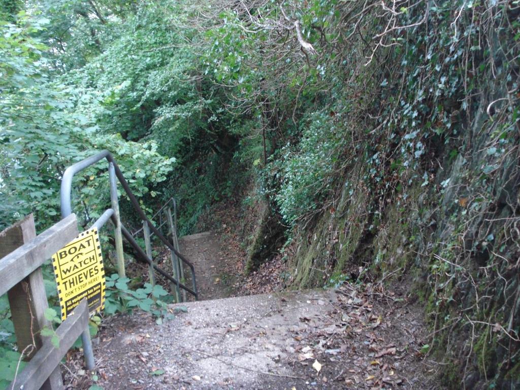
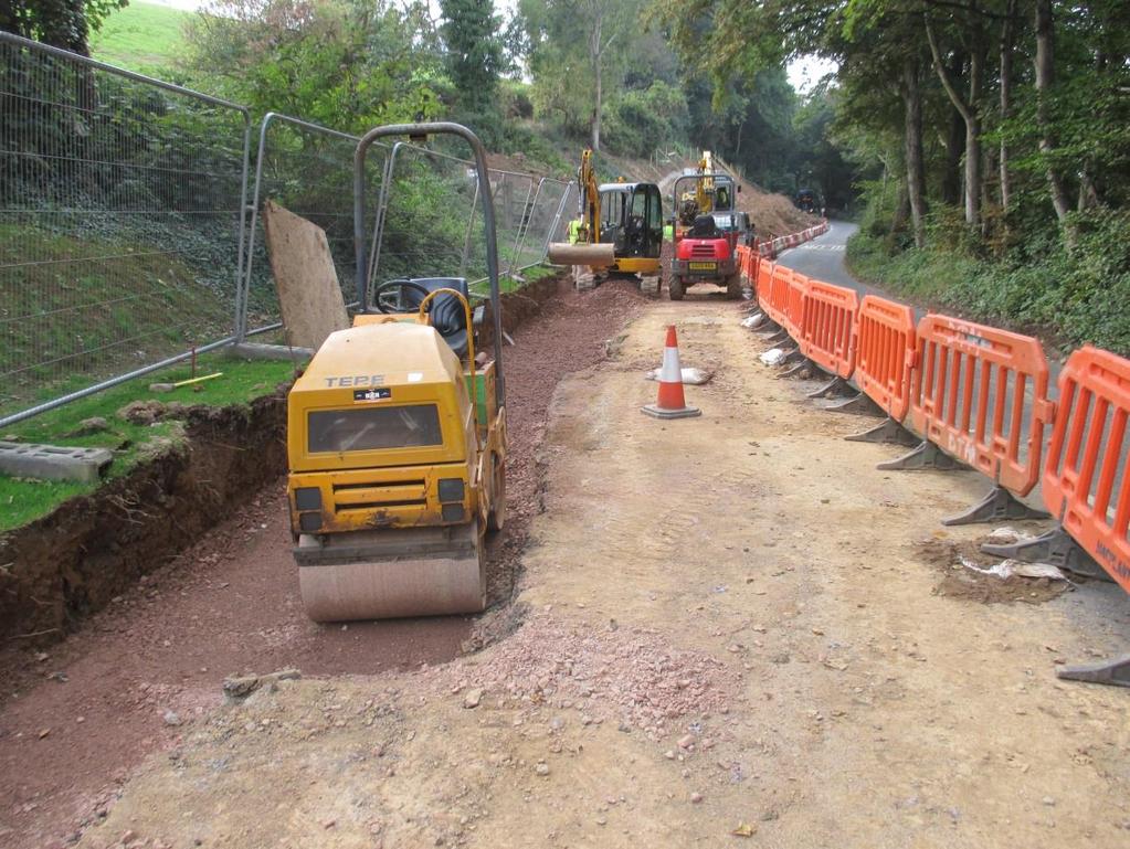
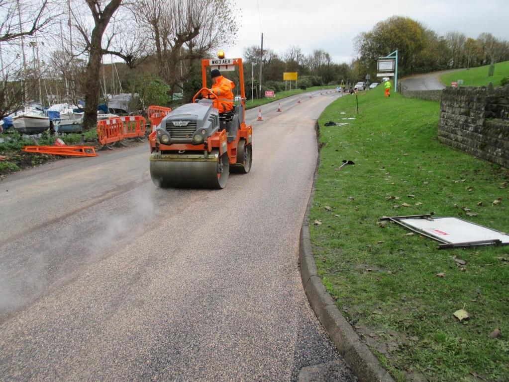
1 Unlocking our Coastal Heritage Strand 2 - Watermouth Bay, nr Ilfracombe In order to provide a safe route for users of the South West Coast Path this project realigned 265m of the A399 coast road to incorporate a 1.2m wide footpath. At a cost of 277,000, the longawaited improvement to the coast path at Watermouth, represents the biggest single investment out of the entire Unlocking our Coastal Heritage project. The project is supported by a grant from the Rural Development Programme for England with additional funds provided by Devon County Council and the South West Coast Path Association. Steve Church from the South West Coast Path Association said: It is great that walkers can at last enjoy this great stretch of Coast Path without having to worry about the tide or risk walking on the busy road. This is our largest ever contribution to a Coast Path improvement project and has been worth every penny to ensure walkers safety and pleasure for many years to come. Prior to this project this section of the South West Coast Path National Trail ran along the foreshore and so is impassable from mid to high tide and at low tide requires negotiation over often wet and slippery rocks. The only alternative route was along the busy A399 between Ilfracombe and Combe Martin which had no footway provision, and so walkers had to walk in the carriageway for approximately 200m around a long sweeping and blind bend. Concerns over this section of the Coast Path have been raised since at least 1993, and various proposals have been put forward over the years to resolve it. As traffic levels and Coast Path usage have increased over the years, resolving the issue has become more urgent. After the Strete Gate to Strete section of the South West Coast Path, this section is considered the most hazardous on the entire 630 mile route. During a safety audit in 2006 it was reported that 3 serious vehicle / pedestrian accidents in the previous 5 years had occurred which prompted the erection of signs to advise walkers not to use the carriageway. This signing was not considered a long term effective solution due to the proximity of popular campsites and destinations, and the overall popularity of this section of Coast Path.
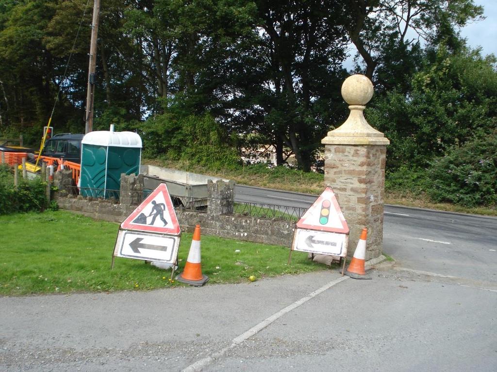
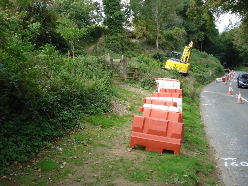
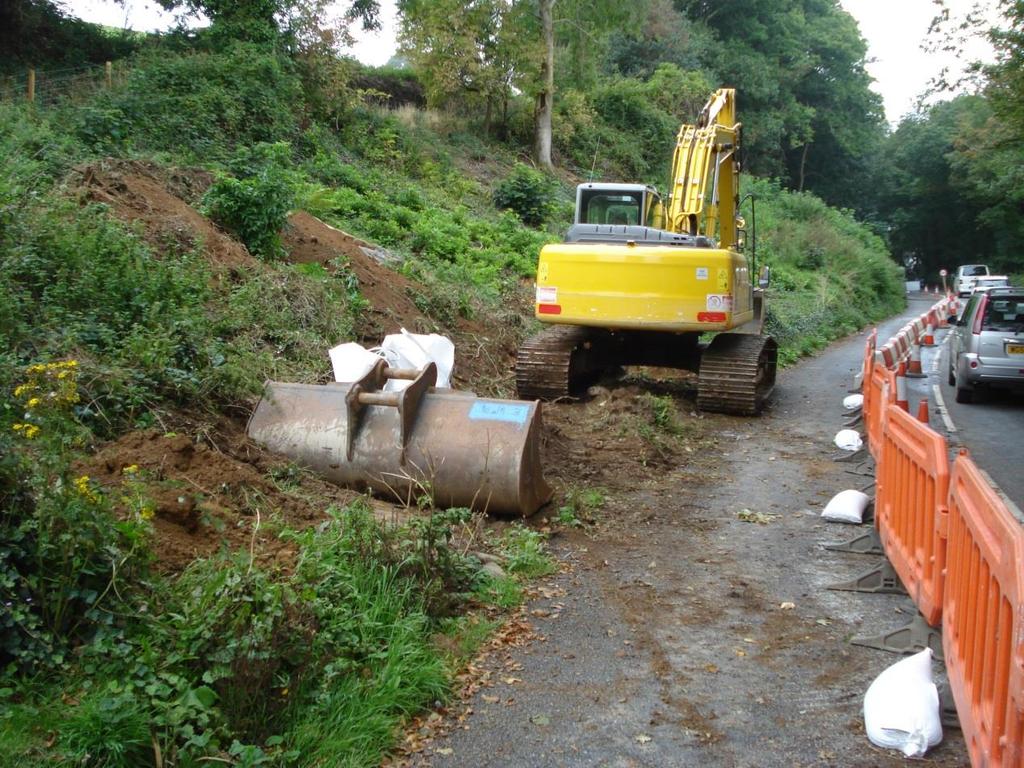
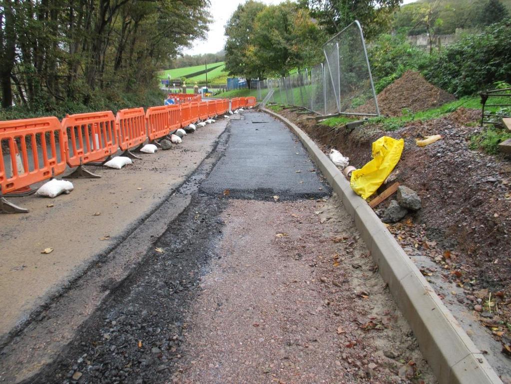
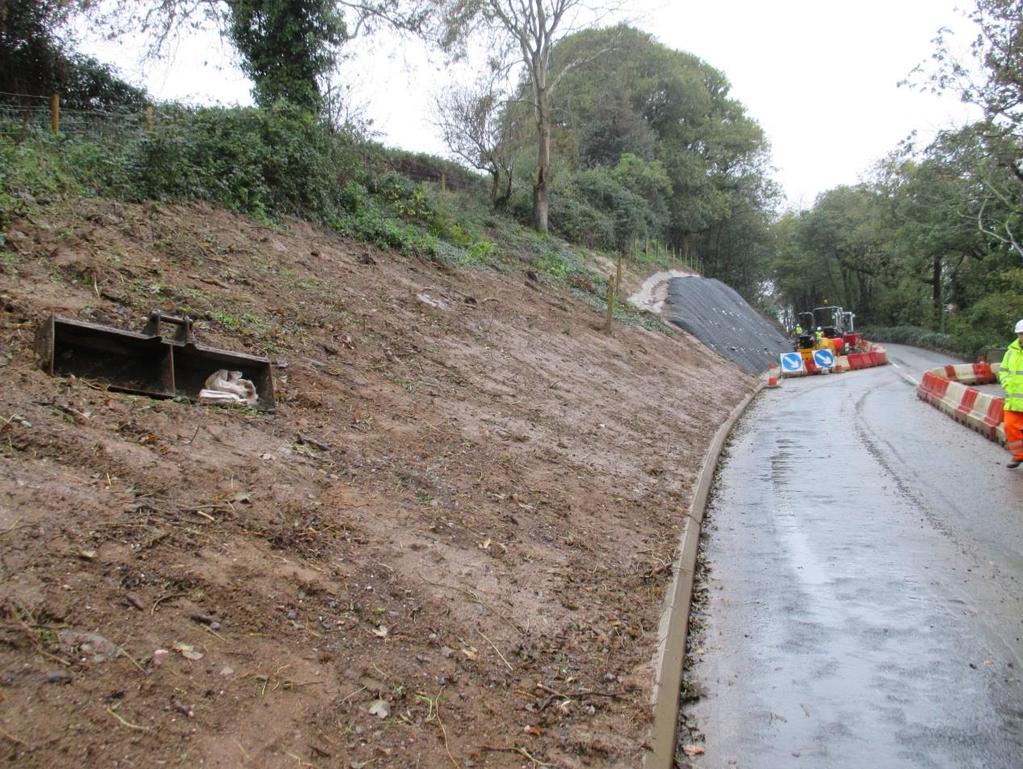
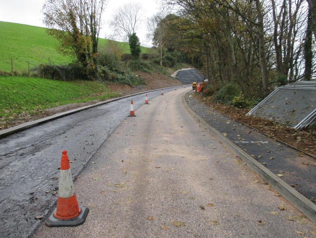
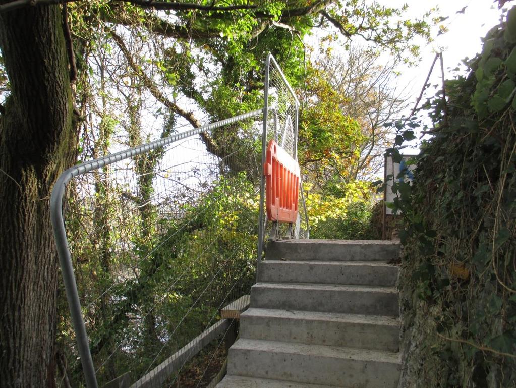
2 The A399 was not wide enough at this location to accommodate any width of footway within the carriageway. To achieve a suitable width the carriageway needed to be realigned and moved westward approximately 2 metres, the majority of which was achieved by utilising highway verge. Where the new footway link joins the old Coast Path the realigned carriageway encroached onto a private bank and cutting (and so needed to be acquired). Due to the nature of the rock and underlying ground conditions the cutting needed stabilising by soil nailing and netting. The proposed footway link as been placed on the eastern boundary of the A399, linking the slip way to an existing cut through in the boundary wall. Behind this wall is the existing Coastal Path steps, that give access back onto the beach, or northwards towards Ilfracombe. As there is a height difference between the A399 and existing path, a small flight of steps was built down to the path below. Construction encountered several issues all of which were successfully resolved. One of these was a medium pressure gas main shown in the wrong location on the Wales and West plans that caused some concern during the design process, but its position was located thanks to a local Wales and West Engineer who nevers throws anything out and had some hand drawn sketches produced when it was installed. The new alignment intersected an existing steep embankment that either had to be moved or steepened. To move the cutting over would have entailed substantial earthworks and escalated the costs beyond the budget, so an engineering solution was needed to be able to further steepen the slope. Following a soil investigation it was decided to stabilize the slope using soil nails and netting. Following the tender process the scheme was awarded to MacPlant Construction Ltd and the work started on 9 th September. The first major operation was the bank stabilization which was carried out by cutting the new slope face and using the excavated material to create a platform for the soil nail drilling rig. Once all the soil nails had been installed then a structural mesh was laid on the face of the slope and secured to the soil nails. Following the slope stabilization the edge of the road was reconstructed, allowing the traffic to be pushed over away from the Bay and with that allowing the new footpath and steps to the SWCP to be built. The final operation was to surface the length of the site and maintain any worn out signing and lining.


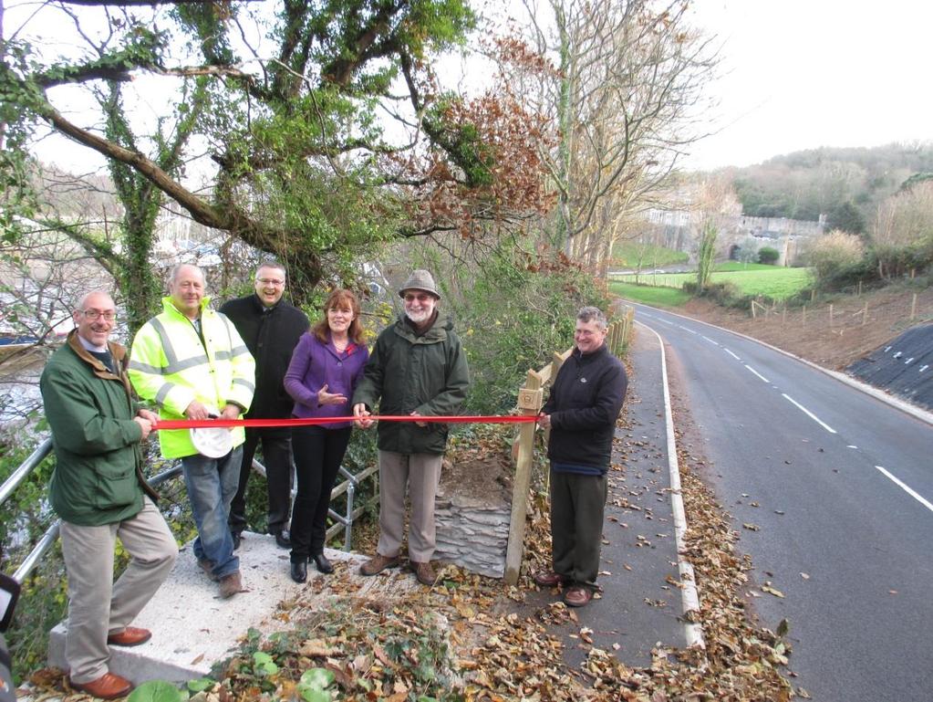
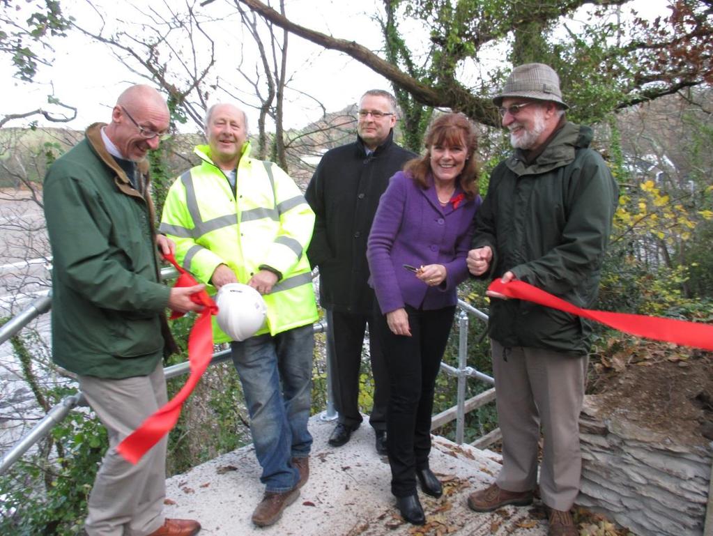
3 The footpath was officially opened on 5 th December 2013 see Before the work started
4

5 Work begins
6
7

8 The pavement is in
9

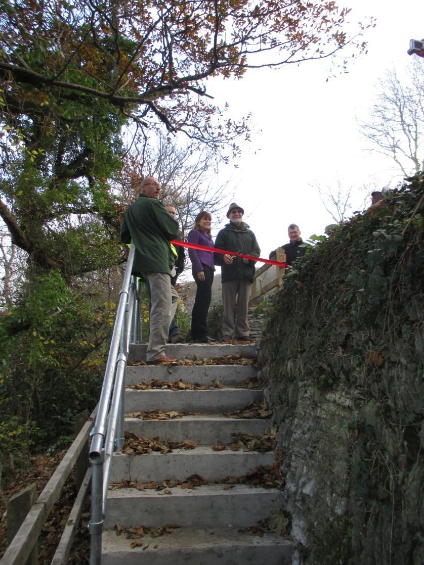
10 The opening ceremonies
11

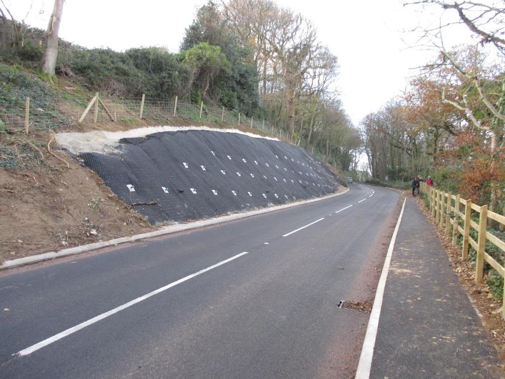
12 The finished project
ACORNS PROJECTS LIMITED
 ACORNS PROJECTS LIMITED A4 London Road, M4 J5 to Sutton Lane, Slough, Berkshire Combined Stage 1 and 2 Road Safety Audit For Slough Borough Council Prepared by Acorns Projects Limited Safety Traffic Project
Centurion Way Chichester
 Centurion Way Chichester Work book of plans to show details of the Centurion Way, its links, and potential developments and enhancements from linking to the South Downs National Park all the way to the
EXPLANATORY STATEMENT
 THE LONDON TO FISHGUARD TRUNK ROAD (A40) (PENBLEWIN TO SLEBECH PARK IMPROVEMENT) ORDER 200- AND THE LONDON TO FISHGUARD TRUNK ROAD (A40) (PENBLEWIN TO SLEBECH PARK IMPROVEMENT SIDE ROADS) ORDER 200-1.
LLANBEDR ACCESS IMPROVEMENTS
 LLANBEDR ACCESS IMPROVEMENTS NON-MOTORISED USER SUPPLEMENTARY REPORT CPF: 5111 Client: Gwynedd Council Document Control Sheet Document Title: Document Author: Project Manager: Project Title: A496 Llanbedr
Community Highways Volunteering Cambridge City Information Pack 2017/18
 Community Highways Volunteering Cambridge City Information Pack 2017/18 Chief Executive Gillian Beasley www.cambridgeshire.gov.uk Contents Welcome to the Community Highways Volunteering Scheme... 2 How
Seek the Board s approval for the Donald Place kerb and channel renewal to progress to final design, tender and construction; and
 3. DONALD PLACE - KERB AND CHANNEL RENEWAL General Manager responsible: General Manager City Environment Officer responsible: Transport and City Streets Manager Author: Michelle Flanagan, Streets Capital
A31 Ringwood improvement scheme
 A31 Ringwood improvement scheme Public consultation June/July 2017 Improving the A31 Ringwood: The proposed improvements will smooth the fl ow of traffic and improve journey time by reducing average delays.
20mph Speed Limit Zones
 Traffic Advisory Leaflet 7/91 May 1991 20mph Speed Limit Zones Summary This leaflet illustrates the main steps in the procedures for the implementation of 20mph zones. It provides brief details on: the
Unlocking Our Coastal Heritage Project: Crane Castle Promontory Fort, Illogan, Cornwall
 Unlocking Our Coastal Heritage Project: Crane Castle Promontory Fort, Illogan, Cornwall As part of a wider project funded by the Rural Development Programme for England (RDPE) and administered through
Speed control humps - Scotland, England and Wales
 Traffic Advisory Leaflet 3/91 September 1991 Speed control humps - Scotland, England and Wales Introduction Road humps are an extremely effective means of keeping vehicle speeds low. The standard round
Appendix 6 Fulbourn Greenway Review
 Appendix 6 Fulbourn Greenway Review Nigel Brigham & Associates A report for 1 Introduction This report is based on fieldwork carried out in 2016 to review the Greenway network around Cambridge as shown
2.2 USER CENSUS DATA A site census estimated on 19/01/2016, together with Sky high 9 day census March 2014.
 2. LEVEL CROSSING USAGE 2.1 RAIL The train service over GREEN DRIFT level crossing consists of passenger and freight trains. There are 154 trains per day. The highest permissible line speed of trains is
Commissioning Director - Environment
 Finchley and Golders Green Area Committee 27 April 2017 Title Report of Wards Status Urgent Key Enclosures Summers Lane,N12 Request for Pedestrian Improvements Commissioning Director - Environment Woodhouse
NOTICE OF REQUIREMENT: NZ TRANSPORT AGENCY: SH6 TARAMAKAU BRIDGE PROJECT
 1 July 2016 Planning Manager Westland District Council 36 Weld Street HOKITIKA Attn Alex Dunn Dear Alex NOTICE OF REQUIREMENT: NZ TRANSPORT AGENCY: SH6 TARAMAKAU BRIDGE PROJECT On 15 June 2016 you issued
Chapter 2 Route window W25 Maidenhead station. Transport for London
 Chapter 2 Route window W25 Maidenhead station MAIDENHEAD STATION 2 Route window W25 Maidenhead station 2.6 The drawings provided at the end of this chapter present the main features of the route window,
Coast Path Survey Stretch 09 Shalfleet Mill to Thorness Bay
 Coast Path Survey Stretch 09 Shalfleet Mill to Thorness Bay Overview Map of stretch Introduction This stretch of Island coast covers several salt marsh creeks backed by grazing land and woodland on the
IOW Ramblers Submission Paper to the Sept 2016 ROW Improvement Plan Consultation.
 IOW Ramblers Submission Paper to the Sept 2016 ROW Improvement Plan Consultation. The current Island Rights of Way Improvement Plan is a comprehensive document and much of its content is still relevant
Felixstowe Branch Line FAQ
 Felixstowe Branch Line FAQ How was the location of the track doubling work decided? We undertook a study to identify how to meet the freight demand along the Felixstowe Branch Line by modelling the route.
STRENGTHENING LOCAL RELATIONSHIPS East Dean & Friston Parish Council Liaison Meeting 7 May 2014 at 10.00am In the Small Hall, East Dean Village Hall
 East Dean & Friston PC Clerk Katrina Larkin Councillor Stephen Shing Councillor Daniel Shing Ian Johnson Principal Traffic and Safety Officer Kevin Morris Highway Steward STRENGTHENING LOCAL RELATIONSHIPS
Derry Hill and Bingley Road, Menston. Accidents waiting to happen.
 Derry Hill and Bingley Road, Menston. Accidents waiting to happen. School Bus unable to pass on Hawksworth Drive References: Derry Hill - 10/04551/MAF Bingley Road - 10/06229/MAO Bingley Road - 11/05691/OUT
Major Scheme Business Case Summary Report for Programme Entry
 Paper A Heart of South West Local Transport Board Major Scheme Business Case Summary Report for Programme Entry M5 Junction 25, Taunton July 2016 1 SCHEME SUMMARY Scheme Name M5 Junction 25, Taunton Date
Roads, Transportation and Safety
 Roscommon County Council s corporate objective as set out in the Corporate Plan 2009 2014 is to Ensure the development of an adequate transport network. The implementation of this objective continued in
Appendix 9 Melbourn Greenway Review
 Appendix 9 Melbourn Greenway Review Nigel Brigham & Associates A report for 1 Introduction This report is based on fieldwork carried out in 2016 to review the Greenway network around Cambridge as shown
INTERNATIONAL CONFERENCE ROAD SAFETY
 INTERNATIONAL CONFERENCE ROAD SAFETY Road Safety Problems of the National Road Network in Greece, especially in the Area of Evia Geotechnical Problems Antonis Kastis Transportation Engineer, Coordinator
Energy from Waste and Recycling Facility Trident Park, Cardiff. Planning History. January 2010 SLR Ref: B
 Energy from Waste and Recycling Facility Trident Park, Cardiff Planning History January 2010 Ref: 402-0036-0306B Viridor Ltd. i 402/0036/00306B CONTENTS 1.0 INTRODUCTION... 1 2.0 GENERAL HISTORY... 3
Planning Committee. Thursday, 26 May 2016
 Planning Committee Thursday, 26 May 2016 Attendees: Substitutes: Councillor Lyn Barton (Member), Councillor Helen Chuah (Member), Councillor Theresa Higgins (Chairman), Councillor Brian Jarvis (Member),
Chapter 6 Route Window NE5 Seven Kings station. Transport for London
 Chapter 6 Route Window NE5 Seven Kings station Transport SEVEN KINGS STATION 6 Route Window NE5 Seven Kings Station Transport Introduction 6.1 All construction activities in this route window are associated
Today we are showing you the early designs to improve the A27 at Arundel and we would like to hear your views on our options.
 Welcome Welcome to the Highways England A27 Arundel Bypass public consultation. Thank you for coming. Today we are showing you the early designs to improve the A27 at Arundel and we would like to hear
Risk Assessment. This risk assessment is fully reviewed on and annual basis. Amendments and additions are incorporated as required.
 KICC is a camping and activity centre located in Kingsdown, Nr Deal, Kent. Set in 40 acres of sloping open grassland the estate enjoys woodland boundaries and unparalleled sea views across the English
The impact of investments & storms on the economic benefits provided by the South West Coast Path National Trail to the region between 2010 and 2014
 Cumulatve increase since 2010 The impact of investments & storms on the economic benefits provided by the South West Coast Path National Trail to the region between 2010 and 2014 Key findings Between 2010
The Network Rail (Suffolk Level Crossing Reduction) Order
 Order") Aidan Dunn Interim Director of Resource Management Suffolk County Council Endeavour House 8 Russell Road Ipswich IP1 2BX Network Rail James Forbes House 27 Great Suffolk St London SE1 0NS 27 July 2017
Aidan Dunn Interim Director of Resource Management Suffolk County Council Endeavour House 8 Russell Road Ipswich IP1 2BX Network Rail James Forbes House 27 Great Suffolk St London SE1 0NS 27 July 2017
United States Department of the Interior National Park Service. Boundary Expansion Listed in National Register January 11, 2017
 NPS Form 10900-a (Rev. 8/2002) OMB No. 10240018 United States Department of the Interior National Park Service Boundary Expansion Listed in National Register January 11, 2017 National Register of Historic
Arrangements for the delivery of minor highway maintenance services by Town and Parish Councils
 Arrangements for the delivery of minor highway maintenance services by Town and Parish Councils Cabinet Date of Meeting 8 March 2017 Officer Cllr Peter Finney, Cabinet Member for Environment, Infrastructure
HADNALL PARISH COUNCIL
 HADNALL PARISH COUNCIL Minutes of the Annual Meeting held at Hadnall Village Hall on 14 th May 2018 at 7.00pm. AM/18/1 AM/18/2 AM/18/3 AM/18/4 Election of Chairman It was proposed, seconded and resolved
MEMORANDUM OF UNDERSTANDING WITH BUSINESS IMPROVEMENT DISTRICTS WITHIN BIRMINGHAM
 MEMORANDUM OF UNDERSTANDING WITH BUSINESS IMPROVEMENT DISTRICTS WITHIN BIRMINGHAM For services in respect of: Highway Maintenance and Management Car Parking Traffic Management Signatories: For Birmingham
4.1.1 Improved facilities and layout cont.
 . Improved facilities and layout The MSF scheme to develop the land adjoining the station involves creating two substantial new ticket halls to replace the existing ones. These new ticket halls will be
Section 6 WHALE CHINE TO FRESHWATER BAY
 Section 6 WHALE CHINE TO FRESHWATER BAY Introduction The route begins at Whale Chine and follows the Public ROW of the existing coastal footpath to the Lifeboat House at Freshwater Bay. The area is characterised
5.7 Local road upgrades
 5.7 Local road upgrades Local roads around the St Peters interchange and the intersection of Campbell Road and Euston Road would be upgraded to ensure safe and efficient connections with the New M5, and
Appendix 7 Local Green Spaces - Detailed Evidence
 Appendix 7 Local Green Spaces - Detailed Evidence Neigh Bridge Country Park, Somerford Keynes General information Neigh Bridge Country Park is situated at the southern entrance to Somerford Keynes village.
CHAPTER 4 -- THE LAND USE PLAN: DESCRIPTIONS AND POLICIES FOR THIRTEEN PLANNING AREAS
 CHAPTER 4 -- THE LAND USE PLAN: DESCRIPTIONS AND POLICIES FOR THIRTEEN PLANNING AREAS NORTH CENTRAL CAC AREA LITTLE VALLEY ROAD TO JUG HANDLE CREEK PLANNING AREA This planning area includes Cleone, Noyo,
THE WELSH MINISTERS STATEMENT OF REASONS
 THE WELSH MINISTERS The Welsh Ministers (The M4 Motorway (Junction 23 (East of Magor) to West of Junction 29 (Castleton) and Connecting Roads) and The M48 Motorway (Junction 23 (East of Magor) Connecting
THE LONDON BOROUGH OF HOUNSLOW (HOUNSLOW HIGH STREET QUARTER) COMPULSORY PURCHASE ORDER 2015 THE LONDON BOROUGH OF HOUNSLOW
 COMPULSORY PURCHASE ORDER 2015 THE LONDON BOROUGH OF HOUNSLOW") THE LONDON BOROUGH OF HOUNSLOW (HOUNSLOW HIGH STREET QUARTER) COMPULSORY PURCHASE ORDER 201 THE LONDON BOROUGH OF HOUNSLOW RESPONSE TO WRITTEN REPRESENTATIONS BY LEGAL AND GENERAL ASSURANCE SOCIETY LIMITED
THE LONDON BOROUGH OF HOUNSLOW (HOUNSLOW HIGH STREET QUARTER) COMPULSORY PURCHASE ORDER 201 THE LONDON BOROUGH OF HOUNSLOW RESPONSE TO WRITTEN REPRESENTATIONS BY LEGAL AND GENERAL ASSURANCE SOCIETY LIMITED
Cammachmore. Community Action Plan Prepared by Newtonhill, Muchalls & Cammachmore Community Council
 Cammachmore Community Action Plan 2012 Prepared by Newtonhill, Muchalls & Cammachmore Community Council Map of Cammachmore obtained from Google maps Introduction In March 2012 Newtonhill, Muchalls & Cammachmore
Report. Recommendation: Mayor and Councillors. To: District Engineer and Roading Manager. From: Date: 11 th April 2012
 Report To: From: Mayor and Councillors District Engineer and Roading Manager Date: 11 th April 2012 File reference: Portfolio holder: Document: 873742 Appendix A: 873811 Appendix B: 871432 Councillor Harris
M4 Junctions 3 to 12 Smart motorway
 Welcome The Highways Agency is proposing to improve the M4 motorway between Junction 3 and Junction 12 by introducing a Smart motorway scheme, which will: Relieve congestion and smooth the flow of traffic
THE PROPOSED NETWORK RAIL (ESSEX AND OTHERS LEVEL CROSSING REDUCTION) ORDER DEPARTMENT FOR TRANSPORT REFERENCE: TWA/17/APP/05
 ORDER DEPARTMENT FOR TRANSPORT REFERENCE: TWA/17/APP/05") OBJ/148/ W 031 E20 SNIVELLERS THE PROPOSED NETWORK RAIL (ESSEX AND OTHERS LEVEL CROSSING REDUCTION) ORDER PUBLIC INQUIRY, 18 OCTOBER 2017 DEPARTMENT FOR TRANSPORT REFERENCE: TWA/17/APP/05 OBJECTION BY
OBJ/148/ W 031 E20 SNIVELLERS THE PROPOSED NETWORK RAIL (ESSEX AND OTHERS LEVEL CROSSING REDUCTION) ORDER PUBLIC INQUIRY, 18 OCTOBER 2017 DEPARTMENT FOR TRANSPORT REFERENCE: TWA/17/APP/05 OBJECTION BY
Commissioning Director - Environment. Officer Contact Details Jane Shipman;
 Chipping Barnet Area Committee 6 July 2016 Title Report of Wards Status Urgent Key Enclosures The Avenue Zebra crossing and pedestrian improvements Commissioning Director - Environment Chipping Barnet
Steve Randall FIHE Technical Manager HW Martin (Traffic Management) Ltd
 Ltd") Steve Randall FIHE Technical Manager HW Martin (Traffic Management) Ltd A453 Widening M1 Junction 24 to A52 Nottingham Project Details Project Details Widen 11.5km of existing single carriageway Project
Steve Randall FIHE Technical Manager HW Martin (Traffic Management) Ltd A453 Widening M1 Junction 24 to A52 Nottingham Project Details Project Details Widen 11.5km of existing single carriageway Project
ADVICE ON Cattle Grids
 ADVICE ON 2 Definition A cattle grid, for highway purposes, is a device designed to prevent the passage of animals, or animals of any particular description, but to allow the passage of all or some other
9 CONSTRUCTION OF BATHURST STREET FROM GREEN LANE WEST TO SOUTH OF HIGHWAY 11, TOWN OF EAST GWILLIMBURY AND TOWNSHIP OF KING
 Clause No. 9 in Report No. 9 of Committee of the Whole was adopted, without amendment, by the Council of The Regional Municipality of York at its meeting held on May 15, 2014. 9 CONSTRUCTION OF BATHURST
MALDON DISTRICT LOCAL HIGHWAY PANEL POTENTIAL SCHEMES LIST (Version 28)
") MALDON DISTRICT LOCAL HIHWAY PANEL POTENTIAL SCHEMES LIST (Version 28) This Potential Scheme List identifies all of the scheme requests which have been received for the consideration of the Maldon District
MALDON DISTRICT LOCAL HIHWAY PANEL POTENTIAL SCHEMES LIST (Version 28) This Potential Scheme List identifies all of the scheme requests which have been received for the consideration of the Maldon District
SUTTON UNDER WHITESTONECLIFFE PARISH COUNCIL
 SUTTON UNDER WHITESTONECLIFFE PARISH COUNCIL A170 Sutton Bank Application for a Permanent Traffic Regulation Order (TRO) for Prohibition of HGVs The purpose of this document is to support a request from
"TOUCAN" - An unsegregated crossing for pedestrians and cyclists
 Traffic Advisory Leaflet 10/93 August 1993 "TOUCAN" - An unsegregated crossing for pedestrians and cyclists Summary This leaflet gives advice on the design and use of the Toucan signal controlled crossing,
Queen s Circus Roundabout
 Stage 2 Road Safety Audit Ref: 1128-RSA-01 Prepared for: Steer Davies Gleave By: Capital Traffic Prepared by: Checked by: Approved by: Andy Haunton, Audit Team Leader Jonathan Thompson, Audit Team Member
Chapter 21 Route window W6 West Ealing station. Transport for London
 Chapter 21 Route window W6 West Ealing station WEST EALING STATION 21 Route window W6 West Ealing station Baseline conditions 21.6 West Ealing station is located in the London Borough of Ealing and is
Introduction of traffic control measures to improve congestion and air quality within the town centre
 Objectives Introduction of traffic control measures to improve congestion and air quality within the town centre Independent of a realignment of the B4009 (new edge road) To focus on the here and now Impact
M2 Junction 5. improvements scheme. Preferred route announcement
 M2 Junction 5 improvements scheme Preferred route announcement May 2018 Investing in your roads Why is the scheme needed? At Highways England we believe in a connected country and our network makes these
Perth and Kinross Council Development Control Committee 27 August 2008 Recommendation by Development Quality Manager
 Perth and Kinross Council Development Control Committee 27 August 2008 Recommendation by Development Quality Manager 5(7) 08/414 Erection of kennels and cattery at Baltree Farm, Hatchbank, Kinross, KY13
SH73 Route Security Strategic Study Project Summary
 November 2009 SH73 Route Security Strategic Study Project Summary Managing Route Security from Springfield to Aickens STATE HIGHWAY 73 SPRINGFIELD TO AICKENS ROUTE SECURITY STRATEGY CONSULTATION 1. Introduction
HANSLOPE PARK CONSULTATIVE AREA FORUM
 HANSLOPE PARK CONSULTATIVE AREA FORUM Wednesday 8 th January 2014 7.30pm Haversham Social & Community Centre Haversham MINUTES 1 Attendees: Cllr Andrew Geary Cllr Ian Burgess Cllr Pam Furniss Mike Morris
Transit s forecasts of expenditure in Waikato for the next 10 years are set out in Table WK1.
 WAIKATO STATE HIGHWAY PLAN EXECUTIVE SUMMARY Transit s forecasts of expenditure in Waikato for the next 10 years are set out in Table WK1. These forecasts of expenditure are based on a 10-year plan of
Road Signs, Markings and Their Meaning
 Road Signs, Markings and Their Meaning FUNCTIONS OF ROAD SIGNS AND MARKINGS 1. Guides 2. Directs 3. Warns 4. Informs 5. Prohibits 6. Regulates CLASSIFICATION OF ROAD SIGNS 1. Warning 2. Regulatory 3. Informatory
4. Safety Concerns Potential Short and Medium-Term Improvements
 NH Route 104 Access Management Study Page 19 4. Safety Concerns Potential Short and Medium-Term Improvements Potential safety improvement strategies are listed by priority based on field observations by
Dublin Airport Update Presented by Pat Molloy
 Dublin Airport Update Presented by Pat Molloy daa Actions from Previous Meetings Action Item Summary 1. PM to confirm the type of fencing that will be erected around the Toberburr road site 2. daa and
A303 Stonehenge Amesbury to Berwick Down
 A303 Stonehenge Amesbury to Berwick Down The case for the scheme Contents The A303 Corridor 4 Amesbury to Berwick Down 5 The case for the scheme 5 Map of the area 6 Objective 1: Transport 7 Objective 2:
Night work update: Hills M2 Motorway and westbound on ramp at Pennant Hills Road
 T 1800 997 057 (free call) E enquiries@northconnex.com.au PO Box 343 Pennant Hills NSW 1715 northconnex.com.au 28 April 2017 Ref: N0075M Night work update: and westbound on ramp at Dear resident, NorthConnex
EPPING FOREST DISTRICT COUNCIL WITH ESSEX COUNTY COUNCIL LOCAL HIGHWAY PANEL 2 nd JULY 2018 REPORT 1 APPROVED SCHEMES UPDATE
 EPPING FOREST DISTRICT COUNCIL WITH ESSEX COUNTY COUNCIL LOCAL HIGHWAY PANEL 2 nd JULY 2018 REPORT 1 APPROVED SCHEMES UPDATE The following report provides an update on the current position of all of the
1932 The Aero Club leased 45 acres from the Saxtons for their first terminal Cook Strait Airways started operations from the Aero Club.
 6. History Pre-European history There is no record of the area (which was very swampy) being of particular significance but the general area around Tasman Bay was used for fishing, eeling and hunting by
Proposals for the Harrogate Road / New Line Junction Improvement Scheme. August / September Supported by:
 Proposals for the Harrogate / New Line Junction Improvement Scheme August / September 2016 Supported by: Introduction Key Benefits Proposals are currently being developed for changes to the junction of
Draft Length 10 Thorness Bay to Cowes Chain Ferry
 Draft Length 10 Thorness Bay to Cowes Chain Ferry Introduction The southern section of this length of coast is largely (mud and sand) beach edged with landslip. Landward of this is agricultural land with
Appendix 8 Sawston Greenway Review
 Appendix 8 Sawston Greenway Review Nigel Brigham & Associates A report for 1 Introduction This report is based on fieldwork carried out in 2016 to review the Greenway network around Cambridge as shown
DAVA WAY. Notes on multi-use access
 DAVA WAY Notes on multi-use access The Dava Way is a 24 mile (38km) waymarked long distance route based largely on the dismantled Highland Railway Line between Forres, near the Moray Coast in north-east
SH6 Route Security Strategic Study Project Summary
 Ocber 2009 SH6 Route Security Strategic Study Project Summary Managing Route Security from Buller Gorge Haast Pass STATE HIGHWAY 6 BULLER GORGE TO HAAST PASS ROUTE SECURITY STRATEGY CONSULTATION 1. Introduction
London Borough of Barnet Traffic & Development Design Team
 London Borough of Barnet Traffic & Development Design Team AERODROME ROAD PEDESTRIAN FACILITY AND BUS STOP INTRODUCTION FEASIBILITY REPORT Job Number: 60668 Doc Ref: S106/12-13/60668 Author: Manoj Kalair
Finchley and Golders Green Area Committee 27 April 2017
 Finchley and Golders Green Area Committee 27 April 2017 Title Report of Wards Status Urgent Key Enclosures Officer Contact Details Junction of Regents Park Road / Tillingbourne Gardens, N3 Commissioning
JOINT TRANSPORTATION BOARD. 10 June Non-key. That subject to the views of the Board,
 JOINT TRANSPORTATION BOARD 10 June 2008 Subject: Director/Head of Service: Decision Issues: Decision: CCC Ward/KCC Division: Summary: To Resolve: Southern Gas Networks Gas Main Replacement Scheme - Broad
3. COLTA / HUGA CONNECTIONS - PRELIMINARY
 9 3. COLTA / HUGA CONNECTIONS - PRELIMINARY 3.1 COLTA The Chain of Lakes Trail Association (COLTA) trail, formerly identified as the Chester Spur Line, was completed and opened for use in June 2011. The
Date: 11 th January, From: Plaistow & Ifold Parish Neighbourhood Plan - Steering Group. Plaistow & Ifold Parish Council
 Date: 11 th January, 2017 From: Plaistow & Ifold Parish Neighbourhood Plan - Steering Group To: Plaistow & Ifold Parish Council Re: Neighbourhood Plan Report to Parish Council Meeting 17 Jan 2017 The Steering
TOWN TRUST. Bury St Edmunds Railway Station
 BURY ST EDMUNDS TOWN TRUST conserving buildings of historic interest The future of Bury St Edmunds Railway Station Part I Report October 2015 1 The future of Bury St Edmunds Railway Station NOTE: This
A63 Castle Street, Hull HullBID Network Lunch 24 August 2017
 A63 Castle Street, Hull HullBID Network Lunch 24 August 2017 James D Leeming Senior Project Manager What we will cover today? Introduction to Highways England and the Road Investment Strategy A63 Scheme
2. Goals and Policies. The following are the adopted Parks and Trails Goals for Stillwater Township:
 D. PARKS AND TRAILS 1. Introduction Stillwater Township s population is relatively low, with most residents living on rural residences on large lots. The need for active park space has been minimal in
Minutes of the Meeting of Shirwell Parish Council held on the 12 th October 2017 in the Village Hall
 Minutes of the Meeting of Shirwell Parish Council held on the 12 th October 2017 in the Village Hall Present Cllr M Pine Chairman Cllr J Friend Vice Chairman Cllr A Conibear Cllr M Hayward Cllr Mrs N Incledon
Hazardous Cattle Crossing: Use of Flashing Amber Lamps
 THE HIGHWAYS AGENCY THE SCOTTISH OFFICE DEVELOPMENT DEPARTMENT THE WELSH OFFICE Y SWYDDFA GYMREIG THE DEPARTMENT OF THE ENVIRONMENT FOR NORTHERN IRELAND Hazardous Cattle Crossing: Use of Flashing Amber
TRANSPORT AND WORKS ACT Proof of Evidence. Andrew Wright Planning and Design Manager Taylor Wimpey East Anglia
 TRANSPORT AND WORKS ACT 1992 Proof of Evidence Andrew Wright Planning and Design Manager Taylor Wimpey East Anglia The Network Rail (Suffolk Level Crossing Reduction Order) Site at Elmswell Development
Regulatory Committee
 Page 1 - Proposed Turning Movement Bans at South Gate Junction, Dorchester Regulatory Committee Date of Meeting 16 March 2017 Officer Subject of Report Executive Summary Andrew Martin Service Director
HENLEAZE, STOKE BISHOP & WESTBURY-ON-TRYM NEIGHBOURHOOD PARTNERSHIP September Chock Lane Traffic Calming scheme Monitoring Report
 HENLEAZE, STOKE BISHOP & WESTBURY-ON-TRYM NEIGHBOURHOOD PARTNERSHIP September 2015 Title: Officer: Chock Lane Traffic Calming scheme Monitoring Report Rob Grieve, Principal Officer, Highways and Traffic,
Chapter 8 Route Window NE7 Chadwell Heath station. Transport for London
 Chapter 8 Route Window NE7 Chadwell Heath station Transport CHADWELL HEATH STATION 8 Route Window NE7 Chadwell Heath station Baseline conditions 8.6 This route window lies within the London Boroughs of
Prince Albert Road Towpath Ramp, Camden Feasibility Report
 Prince Albert Road Towpath Ramp, Camden Feasibility Report Function Location: RE-004 Date: 25 October 2012 Report No: 5016-UA003174-UT31R-03 Prince Albert Road Towpath Ramp, Camden Feasibility Report
Whether travelling on two wheels or two feet, we help communities stay active and sustainable.
 Creating pathways Whether travelling on two wheels or two feet, we help communities stay active and sustainable. Stantec is a local leader in providing cycleway expertise to clients throughout New Zealand.
2.0 POLICY AND DEVELOPMENT FRAMEWORK. Introduction. Transport21. Celbridge Development Plan 2002
 2.0 POLICY AND DEVELOPMENT FRAMEWORK Introduction 2.1 This section of the report highlights the key elements of both Transport21, and the Celbridge Development Plan 2002, both of which include a number
South East Wales Hang Gliding and Paragliding Club Ltd
 Section Release/Amendment Summary Rev Date All Initial issue 1 12/12/2016 Created By: Reviewed By: Approved By: Martin Cray Committee Member Chris Jones Avon Committee Member Management Representative:
Chapter 4 Route window W23 Taplow station. Transport for London
 Chapter 4 Route window W23 Taplow station TAPLOW STATION 4 Route window W23 Taplow station 4.6 Baseline conditions Taplow station Taplow station is located in South Buckinghamshire, 1.5 km southeast of
Thames Estuary Path Hoo Peninsula and Medway Estuary Overview
 Thames Estuary Path Hoo Peninsula and Medway Estuary Overview The Medway Estuary is outside the scope of this study, which concentrates on the Thames waterfront up to Grain Power Station and the north
M621. Junctions 1 to 7 Improvement scheme. Share your views
 M621 Junctions 1 to 7 Improvement scheme Share your views Investing in your roads Every road user wants less congested roads to enable swift, safe, comfortable and informed travel. On behalf of the government,
Uniclass L534+L212. August home zones. paving PRECAST CONCRETE PAVING SOLUTIONS FOR TODAY S RESIDENTIAL STREET ENVIRONMENTS.
 August 2005 Uniclass L534+L212 paving home zones PRECAST CONCRETE PAVING SOLUTIONS FOR TODAY S RESIDENTIAL STREET ENVIRONMENTS www.paving.org.uk Home Zone Principles Home Zones are residential streets
Traffic Calming and Road Safety Provision Options Woore Village
 Traffic Calming and Road Safety Provision Options Woore Village Contents 1 Executive Summary 4 2 Introduction 6 2.1 Background 6 3 Existing Provisions and Conditions 7 3.1 Background supporting option
Spencer Environmental Appendix A: Alternative Analysis for Construction Access Route
 Spencer Environmental Appendix A: Alternative Analysis for Construction Access Route February 2015 Valley ine-stage 1 RT EISA Update FINA REPORT Page A1 Memorandum AECOM ConnectEd Transit Partnership 10235
YHA Hawkshead - Access Statement
 YHA (England & Wales) Trevelyan House, Dimple Road, Matlock, Derbyshire, DE4 3YH Tel. +44(0)1629 592 700 www.yha.org.uk YHA Hawkshead - Access Statement Introduction e looking for a rural retreat in the
Donegal County Council
 Donegal County Council Roads & Transportation Directorate PLANNING AND DEVELOPMENT REGULATIONS 2001 (as amended) Nature and Extent of proposed development in accordance with Part 8 requirements of the
Nelson Mandela Community School, Colville Road, Sparkbrook, Birmingham, B12 8EH. Erection of single storey detached learning pod building
 Committee Date: 7/07/204 Application Number: 204/0362/PA Accepted: 22/05/204 Application Type: Full Planning Target Date: 7/07/204 Ward: Sparkbrook Nelson Mandela Community School, Colville Road, Sparkbrook,