SH73 Route Security Strategic Study Project Summary
|
|
|
- Berenice Joseph
- 5 years ago
- Views:
Transcription


1 November 2009 SH73 Route Security Strategic Study Project Summary Managing Route Security from Springfield to Aickens
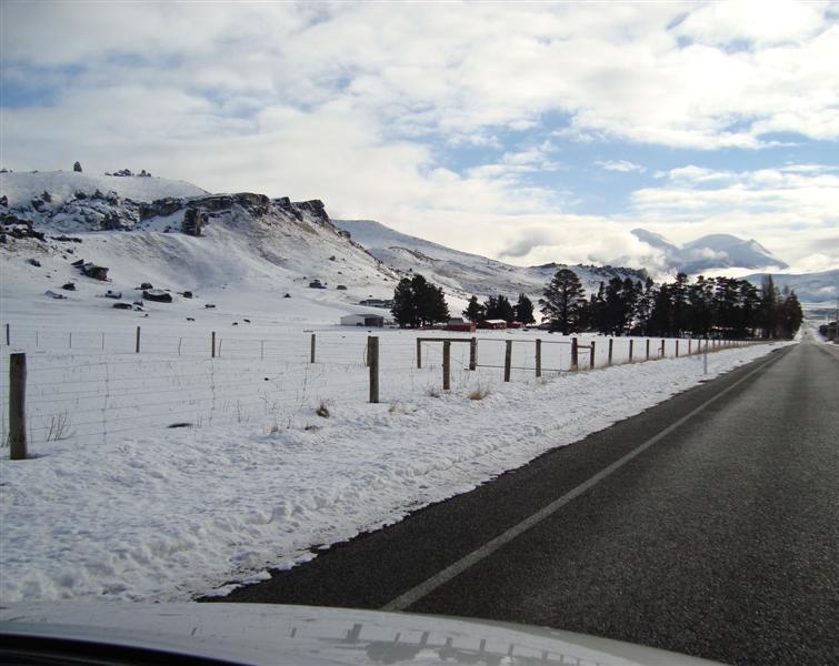
2 STATE HIGHWAY 73 SPRINGFIELD TO AICKENS ROUTE SECURITY STRATEGY CONSULTATION 1. Introduction State Highway 73 is a Regional State Highway in the National State Highway Strategy, and provides often the primary inter-regional link between Canterbury and the West Coast. SH73 provides community linkage from the towns and villages located within the section of highway covered by this study (Springfield, Castle Hill, Cass, Arthur s Pass and Otira) to Christchurch City, Hokitika and Greymouth. SH73 provides access from Canterbury to many recreational activities used by both domestic and international visitors, including skifields during the winter season. The route is recognised as being vital to the economic wellbeing of the West Coast, with increasing numbers of heavy vehicle movements and significant numbers of tourists travelling in campervans, buses or rental cars. Route security is crucial, as severance, depending on location, can result in significant detours. The alternative route from Christchurch to Greymouth via SH7 is considerably longer than SH73, taking around an additional one and a half hours. The most significant threat to the route is slope instability, more specifically rock fall, landslides, debris flows, rock avalanches and frittering (weathering). Additional threats to the route include flooding and river erosion of embankments. This strategic study has identified, investigated and prioritised areas of SH73 subject to route security issues, including threats from rock falls, slope instability, river erosion and flooding. The speed and severity of these hazards require particular expertise to assess the likely damage both to roads and the safety of users, and to consider the optimum period for timely intervention with capital improvements, or if ongoing maintenance is the most viable solution. 2. Purpose of this Document This document is designed to inform you of the Agency s proposed management of the section of SH 73 between Springfield and Aickens for the foreseeable future. The Agency is keen to receive your comments on its proposed Strategy before it is formally adopted. Your comments are important and necessary to ensure the Agency has addressed areas that cause greatest concern to the highway s stakeholders and is your opportunity to raise any further issues. 3. Purpose of the Study The SH 73 Study aims to identify, investigate and prioritise route security and road user safety issues along the highway from Springfield (Canterbury) to Aickens (West Coast), including risks from rock falls, slope instability (including debris flows), civil structures (excluding bridges), river erosion and flooding. The output of this study will be a recommended Strategy and Implementation Plan that will detail a practical and affordable management regime of the highway that will range from continuing current practice to investigating and developing new projects as they are required. Project Number NZTA Page 2 November 2009
3 4. Stakeholder Consultation An initial consultation exercise was completed in January 2009, inviting Stakeholders to provide insight of areas or specific sites where they believed hazards pose a significant risk to the highway and its users. The particular issues of concern within the feedback is summarised as follows: Localised flooding, erosion and washouts occurring in storm events; Snow and ice as a major hazard during winter, including clearance, tree-fall from snow, treatment of road surface for ice, warning signage and blockages caused by stuck vehicles. Rockfall hazards; Dropouts, landslides and slumping Narrow road corridor between Klondyke and Arthurs Pass; Extended closure of SH73 is considered a major impact to West Coast from reduced tourist numbers, inconvenience and cost of increased travel distances. 5. Investigation of Issues At-risk sites have been identified through document and report review, consultation, preliminary risk assessments and a drive-over exercise. In total, twenty five sites have been recognised as potentially problematic, comprising rock fall, landslide, flooding, coastal erosion and debris flow hazards. The sites are shown on the map presented as Figure 1. Each of the sites has been assessed in terms of its geological stability and/or environmental setting and their contributions to route security with an attempt to prioritise sites in terms of seriousness and urgency. The following ten sites are considered the most problematic: Porter s Pass (rock fall, landslide, debris flow, underslips) West of Paddy s (rock fall) Paddy s Bend (rock fall, landslide) White s Bridge (rock fall, landslide) Waimakariri Bluffs and Cornishman s The Deviation (rock fall, underslips, flow) Rise (rock fall, landslide, underslips) Otira Gorge (debris flow, landslide, rock fall, underslips) Bealey Spur (rock fall, landslide, underslip) Otira A, B and C (rock fall, rock flow) Craigieburn Cutting (rock fall, landslide) The issues experienced at these sites are typical for their general area. Consequently, this Study has developed a Corridor Management Strategy approach over an individual site approach, which is considered a more cost effective solution to reducing natural hazard risk along the route. Project Number NZTA Page 3 November 2009

4 NZ Transport Agency Project Number NZTA Page 4 November 2009
5 6. Proposed Corridor Management Plan The section of SH73 covered by this Study has been subdivided into six continuous sub-sections, as shown in Figure 1 and described in Table 1. The table also summarises the typical issues and Management Strategy to be adopted for each section. The proposed Corridor Management Plan has been developed to manage risk along SH73 within the constrained funding that is available and is based on the DNA principle of Detect, Notification, and Action. Detect and Identify risks to road users, route security and the environment through monitoring and surveillance by the Network Consultant and Contractor. Notify risks to NZTA State Highway Manager and affected Stakeholders as appropriate. Action Plan development including emergency response plans, investigation of highest risk sites, exposure and hazard reduction plans. See Figure 2 for the process to be adopted for determining appropriate action. Figure 2: Investigate, Design and Construct Process Route Security Site Normal Activity Unexpected Activity Monitor and Record Activity Small Event Activate Emergency Plan (Warnings, Road Closures, Detours etc.) Major Event Annually Review Monitoring Data. Review Risk Profile Remedial Work Under Network Operations Low Cost Option Undertake Initial Road Opening/ Clearing Where Possible Investigate Remedial Options Low or High Cost Higher Cost Options Secure Emergency Funds for Permanent Repair Submit to RLTP Submit to NLTP Implement Urgent Hazard Reduction Works Prepare Plans for Remedial Works Implement Preplanned Remedial Work New Emergency Work Normal Project Development Project Number NZTA Page 5 November 2009


6 Some of the ways in which hazard and exposure can be reduced comprise the following: Increase driver awareness e.g. through signage. Install more warning signs e.g. No Stopping, Rock Fall. Develop early warning systems for drivers and have response plans in place for the various hazard scenarios, including road closures and diversions when warranted. Close off rest areas or lay-bys in areas of increased exposure. Consider traffic management systems to remove road users from areas of greatest risk. Where physical works are needed to reduce the hazard, this could be in the form of: Improve drainage (rainfall and high ground water most common cause of instability). Preventative maintenance to protect the road (engineered solution such as rockfall netting). Realignment of the road away from the hazard. Porter s Pass Paddy s Bend Waimakariri Bluffs & Cornishman s Rise Otira Gorge Sites Identified as Potentially At-Risk During the SH 73 Strategic Study Otira A, B and C West of Paddy s White s Bridge The Deviation Project Number NZTA Page 6 November 2009
7 Table 1: Summary of Corridor Management Section Length Name RP Description (km) Springfield to 52.86/12.80 Kowai 16 Porters Pass to 76/5.77 Environment Identified Sites Typical Issue(s) Typical Management 5.3km West of Springfield monitoring Upper river valley. Over steepened valley Riverbank and 1km East of Kowai Bluffs Underslip sides. Highway follows Kowai river and embankment then rises to a high point at Porter s Kowai Bluffs inspections Pass. Predominantly farmland, with The Deviation, flow, underslip General and routine elevated areas supporting alpine flora. maintenance of catch Porters Pass, flow, underslip ditches Castle Hill Basin Porters Pass to Cornishman s Rise 76/5.77 to 121/ Alpine basin with several river crossings. Generally flatter terrain with some steep cut embankments present. Alpine vegetation, pasture and bush. Craigieburn Cutting Craigieburn Stream Flock Hill Lake Pearson, landslide River scour below road Rockfall, slumping Localised flooding monitoring Riverbank inspections Traffic management Flood monitoring and response management Waimakariri Cornishman s Rise to Bealey Bridge 121/2.50 to 136/ Road is formed on a steep hill slope overlooking and adjacent to the Waimakariri River. A number of large cuttings are present, with slopes below the road also being steep. Some bush, otherwise alpine vegetation and wilding trees. Cornishman s Rise & Waimakariri Bluffs Paddy s Bend West of Paddy s 350m East of the Poplars Bealey Spur Waimakariri Bridge to Klondyke Corner (southern) Rockfall, underslips Rockfall Rockfall, underslips Localised flooding Rockfall, colluvial instability Flooding, scour of road embankments Rockfall monitoring Riverbank and embankment inspections Flood monitoring and response management Traffic management Bealey Bealey Bridge to Arthur s Pass 136/0.00 to 145/ Road passes over Waimakariri River and is then undulates across steep, hill slopes that overlook the Bealey River. Sub alpine to alpine. Generally native bush covered slopes. Waimakariri Bridge to Klondyke Corner (northern) Public Shelter Mingha Bluff to Rough Ck Flooding, scour of road embankments Rockfall Rockfall, underslips, soil slippage monitoring Riverbank inspections Traffic management Flood monitoring and response management Arthur s Pass to McGrath s Corner and vegetation instability McGrath s Corner, landslide Otira Arthur s Pass to Aickens 145/1.06 to 159/ Steep alpine slopes generally descending to a broader, more gently sloping river valley. Some narrow and very winding sections of road. Dense temperate rainforest on slopes White s Bridge Pegleg Hill Otira Gorge Otira A, B and C Below Starvation Point & Windy Point, debris flow Debris flow, rock fall monitoring Flood and storm management Traffic management Pavement monitoring Wallace Point & Yorkeys Point, debris flow, landslide Big Slip Bridge to Aickens Debris flow Project Number NZTA Page 7 November 2009


.")

8 SH 6 Route Security Strategic Study Project Summary 7. Your Views and Feedback We welcome your comments about the draft strategy before it is finalised in late December Please submit your feedback to GHD (see contact details below) by Friday 4 th December When commenting please provide: Your name; Organisation if appropriate; Daytime and mobile telephone numbers; and address. For further information please contact the Consultant Project Co-ordinator in the first instance, or the Transportation Planning Manager (NZTA). Consultant Project Co-ordinator: Mary O Callahan, GHD Ltd Level 4, 148 Victoria Street PO Box Christchurch 8013 T: F: E: mary.ocallahan@ghd.com Transportation Planning Manager: Michael Blyleven, NZTA NZTA Christchurch Regional Office Level 7, Pacific Brands House 123 Victoria Street PO Box 1479 Christchurch Mail Centre Christchurch 8140 T: F: E: michael.blyleven@nzta.govt.nz Project Number NZTA Page 8 November 2009
SH6 Route Security Strategic Study Project Summary
 Ocber 2009 SH6 Route Security Strategic Study Project Summary Managing Route Security from Buller Gorge Haast Pass STATE HIGHWAY 6 BULLER GORGE TO HAAST PASS ROUTE SECURITY STRATEGY CONSULTATION 1. Introduction
Lake Dunstan Trail Project - Geotechnical Review
 11 July 2018 Oli Monthule-Mcintosh Planning Officer Central Otago District Council 1 Dunorling Street PO Box 122 Alexandra WSP Opus Alexandra Office Tarbert Buildings, 69 Tarbert Street PO Box 273, Alexandra
$745 $10 $41 OVERVIEW
 2015 1 National Land Transport Programme Southern SOUTHERN REGIONAL SUMMARY The NZ Transport Agency s Southern region comprises the local government regions of Canterbury, Otago, Southland and the West
MORGAN CREEK GREENWAY Final Report APPENDICES
 APPENDICES MORGAN CREEK GREENWAY Appendix A Photos of Existing Conditions in Trail Corridor Photos of existing conditions Main trail corridor - February 2009 Photos of existing conditions south bank Morgan
Land Management Summary
 photo credit: ANGAIR Anglesea Heath Land Management Summary The Anglesea Heath (6,501 ha) was incorporated into the Great Otway National Park in January 2018. This provides an opportunity to consider the
NAPAIMUTE TRIBAL SAFETY PLAN Tribal Transportation Program
 Adopted and Approved April 30, 2015 Amended August 2016 NAPAIMUTE TRIBAL SAFETY PLAN Tribal Transportation Program Native Village of Napaimute Napaimute Traditional Council INTRODUCTION The Native Village
City of Durango 5.8 FUNDING TRAILS DEVELOPMENT
 5.8 FUNDING TRAILS DEVELOPMENT The City has been successful in establishing dedicated local funding sources as well as applying for grants to develop the City s trail system, having received nearly $2.4
BACKCOUNTRY TRAIL FLOOD REHABILITATION PROGRAM
 BACKCOUNTRY TRAIL FLOOD REHABILITATION PROGRAM Backcountry Trail Flood Rehabilitation A June 2013 Flood Recovery Program Summary In June 2013, parts of Southern Alberta were devastated from significant
THRESHOLD GUIDELINES FOR AVALANCHE SAFETY MEASURES
 BRITISH COLUMBIA MINISTRY OF TRANSPORTATION & INFRASTRUCTURE AVALANCHE & WEATHER PROGRAMS THRESHOLD GUIDELINES FOR AVALANCHE SAFETY MEASURES British Columbia Ministry of Transportation & Infrastructure
PERTH-ADELAIDE CORRIDOR STRATEGY
 INTRODUCTION The Royal Automobile Association of SA Inc (RAA), the State s principal advocate for motorists on a broad range of motoring-related issues, represents the views of more than 560,000 South
Regional summary - Wellington
 Regional summary Wellington Regional summary - Wellington This is a summary of data relevant to transportation in this region, viewed from a Land Transport NZ perspective. It s purpose is to inform the
CHRISTCHURCH MOTORWAYS. Project Summary Statement February 2010
 CHRISTCHURCH MOTORWAYS Project Summary Statement February 2010 Table of Contents 1. Purpose of Document 2. Strategic Context 3. Benefits 4. Project Scope and Economics 5. Implementation Plan 1 ROADS OF
EAST DON TRAIL ENVIRONMENTAL ASSESSMENT. Community Liaison Committee Meeting #3 July 15, :30 to 8:30 pm Flemingdon Park Library
 EAST DON TRAIL ENVIRONMENTAL ASSESSMENT Community Liaison Committee Meeting #3 July 15, 2013 6:30 to 8:30 pm Flemingdon Park Library Agenda 1. Welcome 2. Housekeeping and Updates a) Housekeeping b) CLC
MEMORANDUM OF UNDERSTANDING WITH BUSINESS IMPROVEMENT DISTRICTS WITHIN BIRMINGHAM
 MEMORANDUM OF UNDERSTANDING WITH BUSINESS IMPROVEMENT DISTRICTS WITHIN BIRMINGHAM For services in respect of: Highway Maintenance and Management Car Parking Traffic Management Signatories: For Birmingham
SUTTON UNDER WHITESTONECLIFFE PARISH COUNCIL
 SUTTON UNDER WHITESTONECLIFFE PARISH COUNCIL A170 Sutton Bank Application for a Permanent Traffic Regulation Order (TRO) for Prohibition of HGVs The purpose of this document is to support a request from
Bear Creek Habitat Improvement Project
 06/10/10 Bear Creek Habitat Improvement Project El Paso County, Colorado Pike National Forest and Colorado Springs Utilities Owned Land Report prepared by: Eric Billmeyer Executive Director Rocky Mountain
VISITOR RISK MANAGEMENT APPLIED TO AVALANCHES IN NEW ZEALAND
 VISITOR RISK MANAGEMENT APPLIED TO AVALANCHES IN NEW ZEALAND Don Bogie*, Department of Conservation, Christchurch, New Zealand Mike Davies, Department of Conservation, Wellington, New Zealand ABSTRACT:
Wellington $312 $49 $456 OVERVIEW WELLINGTON REGIONAL SUMMARY
 National Land Transport Programme 2015 18 Wellington WELLINGTON REGIONAL SUMMARY OVERVIEW The Wellington region is made up of a number of cities, urban areas and supporting rural hinterland. The city is
Mountain Goats and Winter Recreation November 17, 2011
 Mountain Goats and Winter Recreation November 17, 2011 Summary Mountain goats need protection from disruption and displacement in their winter feeding areas by motorized and non-motorized recreationists
$244 $45 OVERVIEW National Land Transport Programme Bay of Plenty BAY OF PLENTY REGIONAL SUMMARY
 2015 18 National Land Transport Programme Bay of Plenty BAY OF PLENTY REGIONAL SUMMARY OVERVIEW Transport investment in the Bay of Plenty is targeted to support significant residential growth, new industrial
Example of the layout of a Fieldwork Atlas
 Example of the layout of a Fieldwork Atlas Example of a Worksite with multiple facilities and work goals in one area: Map Center 49 3 46 N 117 3 11 W Noname Area with typical travel route marked. Avalanche
Non-motorized Trail Plan & Proposal. August 8, 2014
 Town of Star Valley Ranch, Wyoming and the Star Valley Ranch Association in partnership with the USDA Forest Service, Bridger-Teton National Forest, Greys River Ranger District Non-motorized Trail Plan
STRONGER CHRISTCHURCH INFRASTRUCTURE REBUILD TEAM (SCIRT) REAAA
 REAAA") STRONGER CHRISTCHURCH INFRASTRUCTURE REBUILD TEAM (SCIRT) REAAA 21 st August 2012 Context Legend Areas of observed liquefaction! Port Hills area Approx Scale 1:50,000 0 500 1000 1500 2000 2500 (m) Notes:
STRONGER CHRISTCHURCH INFRASTRUCTURE REBUILD TEAM (SCIRT) REAAA 21 st August 2012 Context Legend Areas of observed liquefaction! Port Hills area Approx Scale 1:50,000 0 500 1000 1500 2000 2500 (m) Notes:
Final Environmental Impact Statement for the Merced Wild and Scenic River. Comprehensive Management Plan, Yosemite National Park, Madera and Mariposa
 This document is scheduled to be published in the Federal Register on 02/26/2014 and available online at http://federalregister.gov/a/2014-04061, and on FDsys.gov DEPARTMENT OF THE INTERIOR 4312-FF NATIONAL
Mt. Hood National Forest
 United States Department of Agriculture Forest Service Mt. Hood National Forest Zigzag Ranger District 70220 E. Highway 26 Zigzag, OR 97049 503-622-3191 Fax: 503-622-5622 File Code: 1950-1 Date: June 29,
Energex Loganlea to Jimboomba Network Upgrade Response to Supplementary IAR. Closes 8 April Submission by
 Energex Loganlea to Jimboomba Network Upgrade Response to Supplementary IAR Closes 8 April 2010 Submission by Logan and Albert Conservation Association Prepared by Anne Page (BA Hons Dip Ed M Env Mgt)
Frequently Asked Questions
 CAA Funding Review Why has CAA s funding been reviewed? New Zealand has a well-regarded civil aviation system and a good aviation safety record. However, both the government and a range of reviews (including
Hydro-Electric Schemes Compliance Report June June 2013
 File Reference: 4.00212 Significance of Decision: Receives Only - No Decisions Report To: Operations, Monitoring and Regulation Committee Meeting Date: 20 June 2013 Report From: Nick Zaman, Pollution Prevention
Table of figures. Table of contents. Executive summary... i Introduction... 1 Purpose... 1
 Table of contents Executive summary... i Introduction... 1 Purpose... 1 The corridor at a glance... 2 Corridor overview... 2 The regional economy... 2 Understanding our customers... 3 Key customers...
Gold Coast. Rapid Transit. Chapter twelve Social impact. Chapter content
 Gold Coast Rapid Transit Chapter twelve Social impact Chapter content Social impact assessment process...235 Existing community profile...237 Consultation...238 Social impacts and mitigation strategies...239
ROTORUA INTEGRATED NETWORK STRATEGY
 ROTORUA INTEGRATED NETWORK STRATEGY 2012-2042 May 2013 This photo provided by RDC Cover photos provided by RDC and BOPRC Contents Context Issues for the Strategy to Address Outcomes and Interventions Implementation
Request for Proposal National Tropical Botanical Garden Lower Limahuli Preserve Emergency Stream Debris Removal
 Request for Proposal National Tropical Botanical Garden Lower Limahuli Preserve Emergency Stream Debris Removal I. Summary of Work Bids are solicited for the emergency removal of debris deposited in the
Transit s forecasts of expenditure in Waikato for the next 10 years are set out in Table WK1.
 WAIKATO STATE HIGHWAY PLAN EXECUTIVE SUMMARY Transit s forecasts of expenditure in Waikato for the next 10 years are set out in Table WK1. These forecasts of expenditure are based on a 10-year plan of
Peace Project Water Use Plan
 Peace Project Water Use Plan Williston Reservoir Trial Tributaries Implementation Year 5 Reference: GMSWORKS-19 6 Mile 2016 Engineering Inspection Report Study Period: 2016 KERR WOOD LEIDAL Site Inspection
Unlocking our Coastal Heritage Strand 2 - Watermouth Bay, nr Ilfracombe
 Unlocking our Coastal Heritage Strand 2 - Watermouth Bay, nr Ilfracombe In order to provide a safe route for users of the South West Coast Path this project realigned 265m of the A399 coast road to incorporate
The north half of Section 18, Township 37 North, Range 6 East, Second Principal Meridian, Jefferson Township, Elkhart County, Indiana; also,
 The north half of Section 18, Township 37 North, Range 6 East, Second Principal Meridian, Jefferson Township, Elkhart County, Indiana; also, The east half of Sections 21, 28, and 33, Township 37 North,
Nelson Tasman Cycle Trail Trust Strategic Plan Vision: The Heart of Biking. Purpose. Principles
 Vision: The Heart of Biking Nelson Tasman Cycle Trail Trust Strategic Plan 2015-20 That the Nelson- Tasman region is a premier destination for domestic and international visitors drawn by a range of world
2 THE MASTER PLAN 23
 2 THE MASTER PLAN 23 THE MASTER PLAN 2.1 Purpose of the Master Plan A Master Plan provides the airport operator, the Commonwealth, State and Local Governments, the local community, aviation industries
33. Coiba National Park and its Special Zone of Marine Protection (Panama) N 1138 rev)
 N 1138 rev)") World Heritage status of the area and the Outstanding Universal Value of the Monarch butterfly migration phenomenon, c) Explore options for the development of non-butterfly related tourism activities;
World Heritage status of the area and the Outstanding Universal Value of the Monarch butterfly migration phenomenon, c) Explore options for the development of non-butterfly related tourism activities;
Economic Development Sub- Committee
 Report title: Economic Development Sub- Committee Item No. Date of meeting: 24 November 2016 A47 Road Investment Strategy - update Responsible Chief Tom McCabe Executive Director, Community Officer: and
Traffic Note 32. Use of fluorescent material on traffic signs - guidelines. Date: September Authorisation: Peter Croft, Manager Safer Roads
 Traffic Note 32 page 1 of 6 Traffic Note 32 Date: September 2001 From: Safer Roads Authorisation: Peter Croft, Manager Safer Roads Signature: No. of pages: 6 Use of fluorescent material on traffic signs
Scottish Mountain Rescue Avalanche Burial Organised Rescue Response SCOTTISH MOUNTAIN RESCUE AVALANCHE BURIAL - ORGANISED RESCUE RESPONSE
 Scottish Mountain Rescue Avalanche Burial Organised Rescue Response SCOTTISH MOUNTAIN RESCUE AVALANCHE BURIAL - ORGANISED RESCUE RESPONSE The International Commission for Alpine Rescue (ICAR) recommends
The Government s Aviation Strategy Transport for the North (TfN) response
 response") The Government s Aviation Strategy Transport for the North (TfN) response Transport for the North Background Good transport links are a crucial part of a strong economy supporting labour markets and delivering
The Government s Aviation Strategy Transport for the North (TfN) response Transport for the North Background Good transport links are a crucial part of a strong economy supporting labour markets and delivering
Major Scheme Business Case Summary Report for Programme Entry
 Paper A Heart of South West Local Transport Board Major Scheme Business Case Summary Report for Programme Entry M5 Junction 25, Taunton July 2016 1 SCHEME SUMMARY Scheme Name M5 Junction 25, Taunton Date
Logo Department Name Agency Organization Organization Address Information 5700 North Sabino Canyon Road
 Logo Department Name Agency Organization Organization Address Information United States Forest Coronado National Forest 5700 North Sabino Canyon Road Department of Service Santa Catalina Ranger District
TRANSPORT FOR GREATER MANCHESTER COMMITTEE REPORT FOR RESOLUTION
 TRANSPORT FOR GREATER MANCHESTER COMMITTEE REPORT FOR RESOLUTION DATE: 11 November 2011 SUBJECT: REPORT OF: Proposed making of a Quality Partnership Scheme for the A6 corridor between Manchester and Hazel
M4 Junctions 3 to 12 Smart motorway
 Welcome The Highways Agency is proposing to improve the M4 motorway between Junction 3 and Junction 12 by introducing a Smart motorway scheme, which will: Relieve congestion and smooth the flow of traffic
Monifieth (Potentially Vulnerable Area 07/10) Local Plan District Local authority Main catchment Tay Estuary and Montrose Angus Council, Dundee coasta
 Local Plan District Local authority Main catchment Tay Estuary and Montrose Angus Council, Dundee coasta") Monifieth (Potentially Vulnerable Area 07/10) Local Plan District Tay Estuary and Montrose Basin Local authority Angus Council, Dundee City Council Main catchment Dundee coastal Summary of flooding impacts
Monifieth (Potentially Vulnerable Area 07/10) Local Plan District Tay Estuary and Montrose Basin Local authority Angus Council, Dundee City Council Main catchment Dundee coastal Summary of flooding impacts
KP Lasnaya 1 River
 KP 370.2 Lasnaya 1 River The Lasnaya 1 River crossing is protected by Reno mattings and a gabion wall on the north bank (Photo 1). The south bank consists of natural river gravel deposits on top of Reno
NOISE MANAGEMENT BOARD - GATWICK AIRPORT. Review of NMB/ th April 2018
 NOISE MANAGEMENT BOARD - GATWICK AIRPORT Review of NMB/10 11 th April 2018 Synopsis This paper provides a brief review of the issues discussed at the NMB/10 meeting, which was held on 11 th April. Introduction
Commissioning Director - Environment
 Finchley and Golders Green Area Committee 27 April 2017 Title Report of Wards Status Urgent Key Enclosures Summers Lane,N12 Request for Pedestrian Improvements Commissioning Director - Environment Woodhouse
Community Kea Project Plan
 Community Kea Project Plan Arthur s Pass - Canterbury Funded by: Department of Conservation (CCPF) Period: 1 November 2015 31 October 2017. Key contact person: Kea Conservation Trust Andrea Goodman (phone:
National Land Transport Programme Southland
 National Land Transport Programme 2009 2012 Southland Table of contents Introduction from the Regional Director 1 Regional map 4 Regional summary 5 Regional tables 8 Glossary 12 Key to map abbreviations
Wildlife Management from a Regulatory Perspective
 Wildlife Management from a Regulatory Perspective Description Operators of aircraft have a reasonable expectation that any wildlife hazard which may exist at an airport they use will be managed to a level
Prior to contacting the Whitecourt Trailblazers Snowmobile Club, applicants must:
 WHITECOURT TRAILBLAZERS Box 607 Whitecourt, AB T7S 1N7 www.whitecourttrailblazers.ca CNT AMENDMENT Restriction Code 710: See Comments Comments All applicants are required to contact: Whitecourt Trailblazers
Research Briefing Flood and Coastal Erosion Risk Management in Wales
 Research Briefing Flood and Coastal Erosion Risk Management in Wales Author: Wendy Dodds Date: September 2017 National Assembly for Wales Research Service The National Assembly for Wales is the democratically
A Master Plan is one of the most important documents that can be prepared by an Airport.
 The Master Plan A Master Plan is one of the most important documents that can be prepared by an Airport. A Master Plan is a visionary and a strategic document detailing planning initiatives for the Airport
ROAD AND TRAIL PROJECT APPROVAL
 ROAD AND TRAIL PROJECT APPROVAL www.marincountyparks.org Marin County Parks, 3501 Civic Center Dr, Suite 260, San Rafael, CA 94903 DATE: July 12, 2017 PRESERVE: Gary Giacomini Open Space Preserve PROJECT:
Blackburn Road Blackburn Level Crossing Removal. Frequently Asked Questions August 2014 GENERAL
 Frequently Asked Questions August 2014 Blackburn Road Blackburn Level Crossing Removal GENERAL What is the project? The Victorian Government has committed to eliminating a number of the busiest level crossings
The Strategic Commercial and Procurement Manager
 Item 3 To: Procurement Sub Committee On: 8 June 2016 Report by: The Strategic Commercial and Procurement Manager Heading: Renfrewshire Council s Community Benefit Strategy 2016 1. Summary 1.1. The purpose
ATM STRATEGIC PLAN VOLUME I. Optimising Safety, Capacity, Efficiency and Environment AIRPORTS AUTHORITY OF INDIA DIRECTORATE OF AIR TRAFFIC MANAGEMENT
 AIRPORTS AUTHORITY OF INDIA ATM STRATEGIC PLAN VOLUME I Optimising Safety, Capacity, Efficiency and Environment DIRECTORATE OF AIR TRAFFIC MANAGEMENT Version 1 Dated April 08 Volume I Optimising Safety,
As outlined in the Tatshenshini-Alsek Park Management Agreement, park management will:
 Management Strategy General Strategy The priority management focus for the park is to ensure that its internationally significant natural, cultural heritage and recreational values are protected and that
ACTION PLAN FOR THE PERIOD concerning the STRATEGY ON IMPLEMENTATION OF THE FRAMEWORK AGREEMENT ON THE SAVA RIVER BASIN
 Doc. 1S-26-O-11-5/1-2 ACTION PLAN FOR THE PERIOD 2011-2015 concerning the STRATEGY ON IMPLEMENTATION OF THE FRAMEWORK AGREEMENT ON THE SAVA RIVER BASIN April 2011 Table of Contents INTRODUCTION... 5 1.
Table of figures. Table of contents. Executive summary... i Introduction... 1 Purpose... 1
 Table of contents Executive summary... i Introduction... 1 Purpose... 1 The corridor at a glance... 2 Corridor overview... 2 The regional economy... 2 Understanding our customers... 3 Key customers...
Bibbulmun Track. Cape to Cape Track. Two of the world s great long distance walking tracks. 973 km. 135 km km Off-road cycle touring
 Trail revitalising Western Australia Bibbulmun Track 973 km Cape to Cape Track 135 km Two of the world s great long distance walking tracks 1062 km Off-road cycle touring Trail revitalising 1. Framework
INTRODUCTION. Mailing address: Burke County Community Development Attn: Tim Johnson P. O. Box 219 Morganton, NC
 REQUEST FOR QUALIFICATIONS: PROFESSIONAL, EXPERIENCED TRAIL BUILDERS FOR THE CONSTRUCTION OF THE FONTA FLORA STATE TRAIL LAKE JAMES SECTION BURKE COUNTY COMMUNITY DEVELOPMENT INTRODUCTION Burke County
Port Macquarie-Hastings Pedestrian Access and Mobility Plan. Working Paper COMMUNITY ENGAGEMENT
 Port Macquarie-Hastings Pedestrian Access and Mobility Plan Working Paper COMMUNITY ENGAGEMENT December 2014 Table of Contents Table of Contents... 2 1 Introduction... 3 2 Submissions... 3 2.1 Stakeholder
Rangitikei District Council
 Rangitikei District Council Assets/Infrastructure Committee Meeting Order Paper Thursday 14 July 016 9:30 a.m. Contents 1 3 4 Welcome Council Prayer Apologies/Leave of absence Confirmation of Order of
TAG Guidance Notes on responding to the Civil Aviation Authority s consultation on its Five Year Strategy
 TAG Guidance Notes on responding to the Civil Aviation Authority s consultation on its Five Year Strategy 1. Introduction (Deadline for consultation responses is 19 February 2016) The CAA is currently
Otorohanga Stopbank Pathway - Project Overview
 Otorohanga Stopbank Pathway - Project Overview Introduction Otorohanga District Council with the support of the Otorohanga Community Board are constructing a 3.5 km long gravel pathway for shared use on
High Speed Two: From Crewe to Manchester, West Midlands to Leeds and beyond
 High Speed Two: From Crewe to Manchester, West Midlands to Leeds and beyond Phase 2b Route Decision Moving Britain Ahead July 2017 September 2016 High Speed Two: From Crewe to Manchester, West Midlands
GISBORNE DISTRICT COUNCIL BUSINESS CASE PROPOSAL. Eastland Port Access. Pedestrian Safety Rakaiatane Rd. Page 1 of 4
 GISBORNE DISTRICT COUNCIL BUSINESS CASE PROPOSAL Eastland Port Access Pedestrian Safety Rakaiatane Rd Page 1 of 4 Introduction This proposal has been developed by Gisborne District Council (GDC) to provide
Submission to. Christchurch City Council. on the. Draft Long Term Plan Date: 12 April 2018
 Submission to Christchurch City Council on the Draft Long Term Plan 2018-2028 Date: 12 April 2018 Tourism Industry Aotearoa (TIA) welcomes the opportunity to comment on the Long Term Plan 2018-2028 of
SOUTH INTERCHANGE AREA
 Santaquin City General Plan 1 Location and Characteristics The South Interchange Area of Santaquin is located west of Interstate 15 and south of 500 South (Figure 1). It includes properties already annexed
CHAPTER III: TRAIL DESIGN STANDARDS, SPECIFICATIONS & PERMITS
 CHAPTER III Trail Design Standards, Specifications & Permits This chapter discusses trail standards, preferred surface types for different activities, permits, and other requirements one must consider
January 19, 2018 Project No C Via
 Mr. Thomas McDonald, P.E. Professional Engineer II (C/E) Water Management NYS Canal Corporation 30 S Pearl Street Albany, NY 12207 January 19, 2018 Project No. 16-5719C Via email: thomas.mcdonald@canals.ny.gov
M.J. Milne & Associates Ltd.
 M.J. Milne & Associates Ltd. March, 29 Tolko Industries Ltd. 6 Yellowhead Highway RR#, Site, C Kamloops, BC V2C K Attention: Mr. Michael Bragg, R.P.F. Dear Sir: Re: Risk Rating Evaluation Non-status Roads
EXPLANATORY STATEMENT
 THE LONDON TO FISHGUARD TRUNK ROAD (A40) (PENBLEWIN TO SLEBECH PARK IMPROVEMENT) ORDER 200- AND THE LONDON TO FISHGUARD TRUNK ROAD (A40) (PENBLEWIN TO SLEBECH PARK IMPROVEMENT SIDE ROADS) ORDER 200-1.
Property access tracks
 Property access tracks Planning, location, construction and maintenance The need for farm roads and tracks The efficient running of a property depends on, among other things, ready access to various locations
Post earthquake rockfall protection resilience for a lifeline transmission pylon in Christchurch
 Riding, J.P & Woods, D.J (2017) Post earthquake rockfall protection resilience for a lifeline transmission pylon in Christchurch Proc. 20 th NZGS Geotechnical Symposium. Eds. GJ Alexander & CY Chin, Napier
1. PROJECT BACKGROUND. June 25, Alberta Transportation Central Region #401, Street Red Deer, Alberta T4N 6K8
 Alberta Transportation Central Region #401, 4902 51 Street Red Deer, Alberta T4N 6K8 June 25, 2001 Mr. Melvin Mayfield, P.Eng. Construction Services Coordinator Dear Mr. Mayfield: Central Region Landslide
Appendix 1: Best Management Practices For Hang Gliding and Paragliding in Jasper National Parks
 Appendix 1: Best Management Practices For Hang Gliding and Paragliding in Jasper National Parks Name of Best Management Practice Best Management Practices for Hang Gliding and Paragliding in Jasper National
5 PRECINCT INFRASTRUCTURE PLAN
 The following planning design guidelines should be met. Rainwater tanks are recommended for each dwelling other relevant building structures. Table 10: Category Drainage Drainage Floodplain Management
International Snow Science Workshop
 A PRACTICAL USE OF HISTORIC DATA TO MITIGATE WORKER EXPOSURE TO AVALANCHE HAZARD Jake Elkins Jackson Hole Mountain Resort, Teton Village, Wyoming Bob Comey* Jackson Hole Mountain Resort, Teton Village,
WORKING TOGETHER TO ENHANCE AIRPORT OPERATIONAL SAFETY. Ermenando Silva APEX, in Safety Manager ACI, World
 WORKING TOGETHER TO ENHANCE AIRPORT OPERATIONAL SAFETY Ermenando Silva APEX, in Safety Manager ACI, World Aerodrome Manual The aim and objectives of the aerodrome manual and how it is to be used by operating
Regional impacts and vulnerability mountain areas
 Regional impacts and vulnerability mountain areas 1 st EIONET workshop on climate change vulnerability, impacts and adaptation EEA, Copenhagen, 27-28 Nov 2007 Klaus Radunsky 28 Nov 2007 slide 1 Overview
RIO VISTA MUNICIPAL AIRPORT
 DRAINAGE TECHNICAL MEMORANDUM RIO VISTA MUNICIPAL AIRPORT RIO VISTA, CALIFORNIA Prepared for: City of Rio Vista 1 Main Street Rio Vista, CA 94571 (707) 374-5337 Prepared by: August 2012 Copyright 2012
Gatwick Stream Riverside Garden Park, Horley
 Gatwick Stream Riverside Garden Park, Horley An Advisory Visit by the Wild Trout Trust January 2014 1 1. Introduction This report is the output of a Wild Trout Trust visit to the Gatwick Stream in Horley,
Chuckanut Ridge Fairhaven Highlands EIS Scoping Concerns
 Chuckanut Ridge Fairhaven Highlands EIS Scoping Concerns Coalition of Southside Neighborhoods CSN Comments for Fairhaven Highlands EIS Scope Hearing, Jan 16, 2008 1 Chuckanut Ridge Hilly Terrain: Potential
Manawatu Gorge update 2 December
 Manawatu Gorge update 2 December It s been another full-on week at the gorge. Observation tracks have been made, survey points (nails) have been set, tree felling and scrub clearing is done and the benching
ETOBICOKE CREEK NORTH TRAIL PROJECT. May 18, 2017 at Michael Power High School 105 Eringate Drive, Etobicoke ON M9C 3Z7
 ETOBICOKE CREEK NORTH TRAIL PROJECT May 18, 2017 at Michael Power High School 105 Eringate Drive, Etobicoke ON M9C 3Z7 1 Purpose of Open House The purpose of today s open house is to present the design
Southern Shenandoah Valley Chapter
 Southern Shenandoah Valley Chapter June 7, 2018 Members of the State Water Control Board c/o Office of Regulatory Affairs, Department of Environmental Quality P.O. Box 1105 Richmond, Virginia 23218 citizenboards@deq.virginia.gov
Your Transport Levy Your Transport Future. Sunshine Coast Council Transport Levy Annual Report
 Your Transport Levy Your Transport Future Sunshine Coast Council Transport Levy Annual Report 2016-2017 www.sunshinecoast.qld.gov.au T 07 5475 7272 F 07 5475 7277 Locked Bag 72 Sunshine Coast Mail Centre
2. STAKEHOLDER FEEDBACK // What We Heard
 1. QUARRY ROAD TRAIL // Welcome to the Information Session PROJECT DESCRIPTION WHY WE ARE HERE Quarry Road Trail is a popular commuter trail and recreational area for Calgarians. 1. To report citizen feedback
Draft Strategic Plans for Coillte s eight Business Area Units ( )
") Draft Strategic Plans for Coillte s eight Business Area Units (2011-2015) Response to Public Consultation from Mountaineering Ireland April 2013 1 Introduction Mountaineering Ireland welcomes this opportunity
Draft Strategic Plans for Coillte s eight Business Area Units (2011-2015) Response to Public Consultation from Mountaineering Ireland April 2013 1 Introduction Mountaineering Ireland welcomes this opportunity
SECTION 55A1 ROBINSON TOWNSHIP IN WASHINGTON COUNTY
 WEEK ENDING FEBRUARY 1, 2019 SECTION 55A1 ROBINSON TOWNSHIP IN WASHINGTON COUNTY Contractor: Independence Excavating Inc. 1. Work Shift Day shift (M-F), with Saturday as a makeup day. 2. Traffic The new
Hamilton City Council Transport Strategy
 Hamilton City Council Transport Strategy Where Does Access Hamilton Fit? Strategic Vision Deliver an affordable, integrated, safe, responsive and sustainable transport system. Support economic, social,
Finn Creek Park. Management Direction Statement Amendment
 Finn Creek Park Management Direction Statement Amendment November 2013 Management Direction Statement Amendment Approved by: Jeff Leahy Regional Director, Thompson Cariboo BC Parks November 12, 2013 Date
90 I-90 Snoqualmie Pass East September Annual Mega-Project Report. Project Benefits
 90 I-90 Snoqualmie Pass East September 2015 Annual Mega-Project Report Purpose of this Report The financial and schedule information in this document will assist the Office of Financial Management in meeting
Public Submissions in response to the Bill closed on 2 July 2015 and Council lodged a copy of the submission provided as Attachment 1.
 54 PLANNING AND ECONOMIC COMMITTEE 8 JULY 2015 3 SUSTAINABLE PORTS DEVELOPMENT BILL Neil Quinn 1/58/14 #4771706 RECOMMENDATION: That Council endorses the Submission made to the Infrastructure, Planning