ADVICE ON Cattle Grids
|
|
|
- Bethany Hubbard
- 6 years ago
- Views:
Transcription
1 ADVICE ON
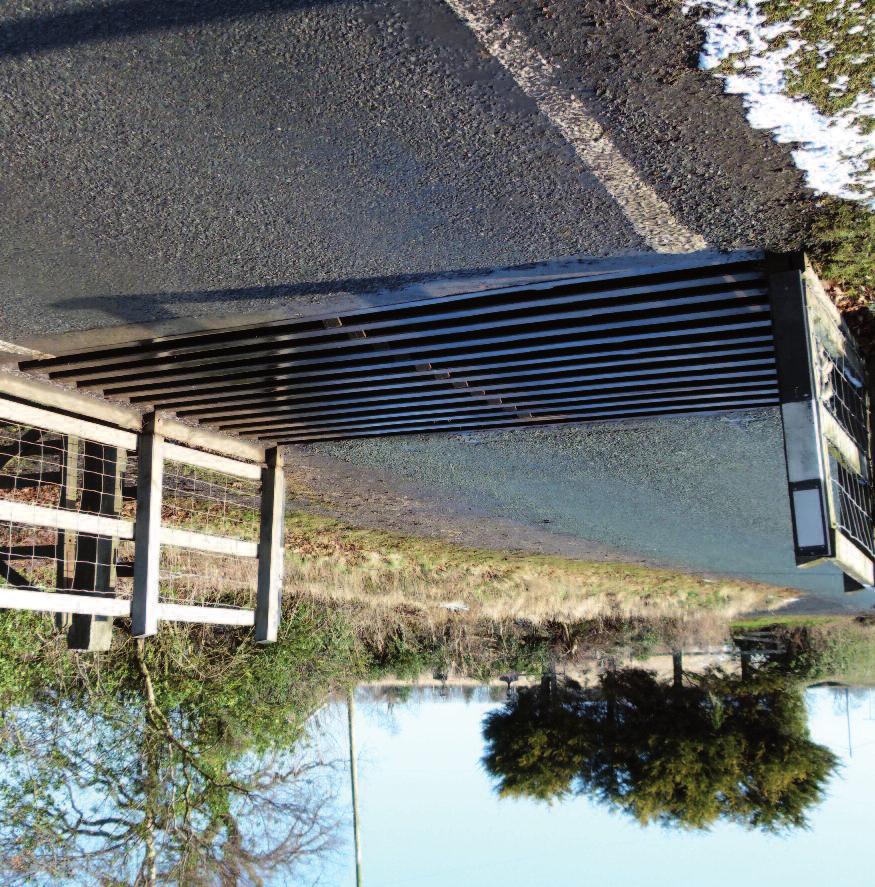
2 2 Definition A cattle grid, for highway purposes, is a device designed to prevent the passage of animals, or animals of any particular description, but to allow the passage of all or some other traffic, and includes any fence or other works necessary for securing the efficient operation of the said device (Highways Act 1980 (HA80) Section 82(6)). Hazard for Horses A horse which runs or steps into a cattle grid is likely to be very severely injured and will usually have to be destroyed. Therefore, it is very important that cattle grids are only installed in full compliance with the law and with best practice, and where no alternative solution to confine livestock is practicable. It is also important that any redundant grids are removed or filled in completely with a hard compacted material or concrete, so that they are not a safety hazard; once they become overgrown with grass or filled with mud or leaves, a rider may not see them until it is too late. Authority for installation The installation of cattle grids on the public highway is covered by HA80 Section inclusive and Schedule 10. Exceptionally, cattle grids in the New Forest can be provided under the New Forest Act 1964 but are not dealt with here (NFA64s3). Who may install? On public carriageways, only the highway authority may install cattle grids, though they may do it at the request of another party. Where can they be installed? Under HA80 Section 82 a cattle grid may only be constructed in a carriageway. This does not include bridleways and footpaths. See Private (below) for installations on bridleways. Procedure When it is proposed to construct a cattle grid in a highway the procedures in the Act must be followed and these include the publication of notices in the local press and posted adjacent to the site. There is provision for objections to be heard (HA80 Schedule 10).
3 Bypasses When a grid is constructed it must have facilities for the passage of... all other traffic unable to pass over the cattle-grid. Other traffic will include driven or led animals under proper control, handcarts, ridden horses and wheeled vehicles drawn by animals (HA80s82(2)). That is, within the width of the carriageway. If the carriageway is too narrow for both the cattle grid and bypass, then additional width must be dedicated as highway. The bypass must be wide enough to carry all legitimate traffic and any gate fitted may not be less than 10 feet wide (HA80s145). * NB There is a British Standard Specification No. BS 4008:2006 for the provision of cattle grids, and BS 5709:2006 for gaps, gates and stiles. The Society was party to their compilation and strongly advises that they should be observed. The British Horse Society recommends that the hinges of the gate should always be on the side of the gate nearest the grid. When existing bypass gates that have been hung with the catch next to the grid are being replaced or repaired, they should be re-hung with the hinges next to the grid. There must be a barrier between the grid and the bypass, extending well beyond the grid, so that horses cannot inadvertently tread on the grid. With larger farm machinery and wider access required, a cattle grid and bypass gate combination is known where the latching post of the gate is next to the grid and both the post and the fence protecting users from the grid can be removed to allow access using the full width of the track. In this situation, the gate must be installed adjacent to the centre point of the side of the grid, so that a horse is still protected from the grid when opening the gate from either direction (the side of the grid being parallel to the line of vehicular travel). All bypass gates should be across the highway, in line with the middle of the grid, and not at an angle to the grid or set in a fence parallel to the highway, since the latter means that there is no guard between the ridden horse and the grid. There should also be sufficient clear manoeuvring space (a minimum of 1.8 metres and preferably two metres) between the gate catch and any fencing at right angles to the gate, so as to enable horse riders to operate the gate safely without dismounting. The Society's advice note about gates should be read in conjunction with this advice note; much of the advice it contains applies equally to cattle grid bypass gates. 3
4 4 The Society recommends that on roads with two lanes, unless the road has a separate two way track for equestrians alongside it, bypasses should be provided on both sides of the cattle grid, so as to avoid the hazards caused by ridden and driven horses crossing and re-crossing the other lane of traffic in order to use the bypass. Indicative layouts Drawings of indicative cattle grid, bypass and gate layouts below. By pass gate with minimum 3.05m opening gate to be hinged at grid end Where recommendations and indicative layout differ from British Standard specifications the Society will be proposing revisions to the standard next time it is revised 2m of fence between gate and fencing Grass verge Grass verge Guard Fences Cattle grid Private cattle grids An access track on private land may coincide with a public right of way and cattle grids may be requested for stock control to replace a gate on a track that is a bridleway or byway. If the public right of way is a carriageway (a Byway Open to All Traffic or a Restricted Byway) then a grid may be installed in the highway subject to the provisions of the 1980 Act as indicated above. However, under the Act, the highway authority would then be responsible for maintaining the cattle grid, bypass and any gates associated with it. The highway authority will need to consider very carefully whether it is expedient for it to take on this responsibility when the cattle grid is to facilitate the passage of private motor vehicular traffic and not public access. If the public right is that of bridleway or footpath, then a cattle grid cannot legally be constructed in the highway and to do so would cause an obstruction. It has been argued that a cattle grid may be provided on a bridleway or footpath under Section 147 of the Highways Act, and in a letter of 10 August
5 2009, the Secretary of State adopted this view if the width of the bridleway or footpath could accommodate a gate and safety fencing as well as the cattle grid. The Society considers this interpretation to be legally doubtful, substantiated by the conclusion in Kind (v Northumberland County Council [2012] EWHC 603) that the Act does not permit other works which force users off the right of way and because it compromises equality of access where there is currently no obstruction to free passage of all users. Kind was a High Court case in which a footpath along a farm track road access was upgraded by modification order to a bridleway with a cattle grid across the full width of the track and a bypass gate off the line of the highway. It was upheld that a cattle grid cannot be authorised as an obstruction of the whole width of a right of way and that an informal bypass off the highway is not adequate The Society recommends that where it is proposed to install a cattle grid in a private road which carries a public bridleway or footpath, the landowner should either: (i) build the grid beside the public path and gate the path so that the right of way remains on its existing line; or (ii) seek a legal diversion to divert the public path through a bypass at the side of the proposed grid. If the gate is to be a new provision, then authorisation for the structure must be sought from the highway authority. Such a gate, on a bridleway, may not be less than 1.525m (5ft) wide between the posts and should meet the Society s recommendations for manoeuvring space, latch and all other criteria in its guidance (BHS advice on Gates or Gate Installation). 5 Cattle grids on common land HA80s82(4) governs the placing of any part of a cattle grid and its bypass(es) in common or waste land adjoining a carriageway. However, the provision of cattle grids elsewhere on common land is governed by the Commons Act 2006 Section 38, and will require the Secretary of State s permission unless it is covered by one of the exceptions. Many commons carry rights of access for air and exercise on horseback (often wrongly referred to as permissive access for ridden horses) and horse riders are strongly recommended to contact their County or Regional BHS Access and Bridleway Officer, or the BHS Access and Rights of Way Department, immediately they become aware of a proposal for any new cattle grid on, or adjacent to, common land.
6 6 If this advice note is a printed copy, please check for the latest version on For more information on The British Horse Society s rights of way work contact: Access and Rights of Way Department, The British Horse Society, Abbey Park, Stareton, Kenilworth, Warwickshire CV8 2XZ Tel: access@bhs.org.uk 11/2017 This advice note applies to England and Wales. For information on Scotland, contact Helene Mauchlen, National Manager for Scotland, Woodburn, Crieff, Perthshire PH7 3RG Tel: helene.mauchlen@bhs.org.uk For information on Northern Ireland please contact Susan Spratt, National Manager for Ireland, Hawks Hill Cottage, 26 Portaferry Road, Greyabbey, Newtownards, Co. Down BT22 2RU Tel: Mob: susan.spratt@bhs.org.uk The British Horse Society is a Registered Charity Nos and SC038516
BHS ADVICE ON Dimensions of Width, Area and Height
 BHS ADVICE ON Dimensions of Width, Area and Height 2 In providing specifications for equestrian ways and facilities, The British Horse Society considers all equestrian users, which may result in a high
Traffic Calming Special Authorisations
 Traffic Advisory Leaflet 3/93 May 1993 Traffic Calming Special Authorisations Introduction Legislation is now available to allow a wide range of traffic calming measures to be used on public roads. Some
IOW Ramblers Submission Paper to the Sept 2016 ROW Improvement Plan Consultation.
 IOW Ramblers Submission Paper to the Sept 2016 ROW Improvement Plan Consultation. The current Island Rights of Way Improvement Plan is a comprehensive document and much of its content is still relevant
Felixstowe Branch Line FAQ
 Felixstowe Branch Line FAQ How was the location of the track doubling work decided? We undertook a study to identify how to meet the freight demand along the Felixstowe Branch Line by modelling the route.
LLANBEDR ACCESS IMPROVEMENTS
 LLANBEDR ACCESS IMPROVEMENTS NON-MOTORISED USER SUPPLEMENTARY REPORT CPF: 5111 Client: Gwynedd Council Document Control Sheet Document Title: Document Author: Project Manager: Project Title: A496 Llanbedr
Level Crossings Configuration Standards
 Discipline: Engineering (Track & Civil) Category: Standard Level Crossings Configuration Standards ETD-16-04 Applicability New South Wales CRIA (NSW CRN) Primary Source ARTC NSW Standard XDS 01 Document
Hazardous Cattle Crossing: Use of Flashing Amber Lamps
 THE HIGHWAYS AGENCY THE SCOTTISH OFFICE DEVELOPMENT DEPARTMENT THE WELSH OFFICE Y SWYDDFA GYMREIG THE DEPARTMENT OF THE ENVIRONMENT FOR NORTHERN IRELAND Hazardous Cattle Crossing: Use of Flashing Amber
Perth and Kinross Council Development Control Committee 27 August 2008 Recommendation by Development Quality Manager
 Perth and Kinross Council Development Control Committee 27 August 2008 Recommendation by Development Quality Manager 5(7) 08/414 Erection of kennels and cattery at Baltree Farm, Hatchbank, Kinross, KY13
20mph Speed Limit Zones
 Traffic Advisory Leaflet 7/91 May 1991 20mph Speed Limit Zones Summary This leaflet illustrates the main steps in the procedures for the implementation of 20mph zones. It provides brief details on: the
Quality Standards for National Trails and the Wales Coast Path. for
 Quality Standards for National Trails and the Wales Coast Path for Edition 3.1 August 2016 THE STANDARDS Surface & Surroundings Page S1 Surfaces and surroundings should be unobstructed so that they are
Date: 11 th January, From: Plaistow & Ifold Parish Neighbourhood Plan - Steering Group. Plaistow & Ifold Parish Council
 Date: 11 th January, 2017 From: Plaistow & Ifold Parish Neighbourhood Plan - Steering Group To: Plaistow & Ifold Parish Council Re: Neighbourhood Plan Report to Parish Council Meeting 17 Jan 2017 The Steering
BORDERS ABBEYS WAY MULTI-USE NOTES
 BORDERS ABBEYS WAY MULTI-USE NOTES The Borders Abbeys Way is a 68 mile waymarked circular route linking four of the Scottish Borders ruined abbeys: Melrose, Dryburgh, Kelso and Jedburgh. Following a mixture
Rule Governing the Designation and Establishment of All-Terrain Vehicle Use Trails on State Land
 Rule Governing the Designation and Establishment of All-Terrain Vehicle Use Trails on State Land 1.0 Authority 1.1 This rule is promulgated pursuant to 23 V.S.A. 3506. Section 3506 (b)(4) states that an
Speed control humps - Scotland, England and Wales
 Traffic Advisory Leaflet 3/91 September 1991 Speed control humps - Scotland, England and Wales Introduction Road humps are an extremely effective means of keeping vehicle speeds low. The standard round
DAVA WAY. Notes on multi-use access
 DAVA WAY Notes on multi-use access The Dava Way is a 24 mile (38km) waymarked long distance route based largely on the dismantled Highland Railway Line between Forres, near the Moray Coast in north-east
Bridge School, Longmoor Campus, Coppice View Road, Sutton Coldfield, Birmingham, B73 6UE
 Committee Date: 22/01/2015 Application Number: 2014/05949/PA Accepted: 08/12/2014 Application Type: Full Planning Target Date: 02/02/2015 Ward: Sutton Vesey Bridge School, Longmoor Campus, Coppice View
Section 6 WHALE CHINE TO FRESHWATER BAY
 Section 6 WHALE CHINE TO FRESHWATER BAY Introduction The route begins at Whale Chine and follows the Public ROW of the existing coastal footpath to the Lifeboat House at Freshwater Bay. The area is characterised
CHAPTER 16 STREETS, SIDEWALKS AND OTHER PUBLIC PLACES*
 CHAPTER 16 STREETS, SIDEWALKS AND OTHER PUBLIC PLACES* *Cross reference(s)--drainage commission, 2-111 et seq.; drainage districts created, 2-114; planning commission shall select and recommend to the
COWAL WAY MULTI-USE ACCESS NOTES
 COWAL WAY MULTI-USE ACCESS NOTES The Cowal Way is a 57 mile long distance path. Starting at Portavadie, it winds its way up through the Cowal peninsula via Tighnabruich, Glendaruel, Strachur, Lochgoilhead
The Network Rail (Suffolk Level Crossing Reduction) Order
 Order") Aidan Dunn Interim Director of Resource Management Suffolk County Council Endeavour House 8 Russell Road Ipswich IP1 2BX Network Rail James Forbes House 27 Great Suffolk St London SE1 0NS 27 July 2017
Aidan Dunn Interim Director of Resource Management Suffolk County Council Endeavour House 8 Russell Road Ipswich IP1 2BX Network Rail James Forbes House 27 Great Suffolk St London SE1 0NS 27 July 2017
Kelly Motorized Trails Project Proposed Action
 Kelly Motorized Trails Project Proposed Action November 28, 2011 The Flagstaff Ranger District of the Coconino National Forest is seeking public input on the proposed Kelly Motorized Trails Project (formerly
MORAY COAST TRAIL - Notes on multi-use access
 MORAY COAST TRAIL - Notes on multi-use access The Moray Coast Trail in the north-east of Scotland is one of Scotland s Great Trails. Approximately 50 miles long, the route links settlements between Findhorn
WEST HIGHLAND WAY Notes on multi-use access
 WEST HIGHLAND WAY Notes on multi-use access The West Highland Way was one of Scotland s four original long distance routes. Now one of Scotland s Great Trails, it is renowned world-wide for the spectacular
All reports. 1. Governance Service receive draft report Name of GSO DPR
 DELEGATED POWERS REPORT NO. SUBJECT: Redevelopment at Grahame Park Estate, NW9, Phase 1B Sub-phase 1 Highways Agreement under Sections 38 and 278 of the Highways Act 1980. Control sheet All of the following
Suffolk Local Access Forum s (SLAF) response to Network Rail s consultation on level crossing closures.
 response to Network Rail s consultation on level crossing closures.") SLAF Suffolk Local Access Forum SLAF PO Box 872 Ipswich Suffolk IP1 9JW Network Rail Anglia Level Crossings Tel: 01473 264452 Fax: 01473 216877 Email: slaf@suffolk.gov.uk Web: http://publicrightsofway.onesuffolk.net/suffolk
SLAF Suffolk Local Access Forum SLAF PO Box 872 Ipswich Suffolk IP1 9JW Network Rail Anglia Level Crossings Tel: 01473 264452 Fax: 01473 216877 Email: slaf@suffolk.gov.uk Web: http://publicrightsofway.onesuffolk.net/suffolk
"TOUCAN" - An unsegregated crossing for pedestrians and cyclists
 Traffic Advisory Leaflet 10/93 August 1993 "TOUCAN" - An unsegregated crossing for pedestrians and cyclists Summary This leaflet gives advice on the design and use of the Toucan signal controlled crossing,
Uniclass L534+L212. August home zones. paving PRECAST CONCRETE PAVING SOLUTIONS FOR TODAY S RESIDENTIAL STREET ENVIRONMENTS.
 August 2005 Uniclass L534+L212 paving home zones PRECAST CONCRETE PAVING SOLUTIONS FOR TODAY S RESIDENTIAL STREET ENVIRONMENTS www.paving.org.uk Home Zone Principles Home Zones are residential streets
Management Standards for Recreational Trails
 Management Standards for Recreational Trails First edition October 2008 The National Trails Office The National Trails Office (NTO) is a programme run by the Irish Sports Council building on the work of
1.2 If the Council is satisfied that traffic on a road should be prohibited for the purpose of:
 APPENDIX 2 POLICY/PROCEDURE IN REGARD TO TEMPORARY ROAD CLOSURES ON THE COUNTY ROAD NETWORK FOR EVENTS ON O'R NEAR THE HIGHWAY. (Not in respect of a footpath, bridleway, cycle track or byway) 1.0 INTRODUCTION
GAWLER AIRFIELD OPERATIONAL GUIDELINES
 By-Law 7 GAWLER AIRFIELD OPERATIONAL GUIDELINES Applicability This document replaces all other documents relating to flying operations at the Gawler Airfield. It takes effect from 26/04/2016. These guidelines
THE PROPOSED NETWORK RAIL (ESSEX AND OTHERS LEVEL CROSSING REDUCTION) ORDER DEPARTMENT FOR TRANSPORT REFERENCE: TWA/17/APP/05
 ORDER DEPARTMENT FOR TRANSPORT REFERENCE: TWA/17/APP/05") OBJ/148/ W 031 E20 SNIVELLERS THE PROPOSED NETWORK RAIL (ESSEX AND OTHERS LEVEL CROSSING REDUCTION) ORDER PUBLIC INQUIRY, 18 OCTOBER 2017 DEPARTMENT FOR TRANSPORT REFERENCE: TWA/17/APP/05 OBJECTION BY
OBJ/148/ W 031 E20 SNIVELLERS THE PROPOSED NETWORK RAIL (ESSEX AND OTHERS LEVEL CROSSING REDUCTION) ORDER PUBLIC INQUIRY, 18 OCTOBER 2017 DEPARTMENT FOR TRANSPORT REFERENCE: TWA/17/APP/05 OBJECTION BY
2011 No ROAD TRAFFIC. The Traffic Signs (Amendment) Regulations and General Directions 2011
 Regulations and General Directions 2011") STATUTORY INSTRUMENTS 2011 No. 1040 ROAD TRAFFIC The Traffic Signs (Amendment) Regulations and General Directions 2011 Made - - - - 30th March 2011 Laid before Parliament 6th April 2011 Coming into force
STATUTORY INSTRUMENTS 2011 No. 1040 ROAD TRAFFIC The Traffic Signs (Amendment) Regulations and General Directions 2011 Made - - - - 30th March 2011 Laid before Parliament 6th April 2011 Coming into force
Aspen Skiing Company Policy for Use of Other Power-Driven Mobility Devices And Service Animals
 Aspen Skiing Company Policy for Use of Other Power-Driven Mobility Devices And Service Animals Introduction New rules under the Americans with Disabilities Act (ADA), Titles II and III, went into effect
British Horse Society-Scotland Developing Falkirk s Access Network- In the Hoof Prints of the Kelpies!
 British Horse Society-Scotland Developing Falkirk s Access Network- In the Hoof Prints of the Kelpies! Angus Duncan Outdoor Access Team Leader - Falkirk Council Facts about Falkirk Local Authority Area:
Consideration will be given to other methods of compliance which may be presented to the Authority.
 Advisory Circular AC 139-11 Revision 2 Use of day-vfr aerodromes 27 April 2007 General Civil Aviation Authority advisory circulars (AC) contain information about standards, practices and procedures that
PERTH AND KINROSS COUNCIL
 PERTH AND KINROSS COUNCIL Fossoway Llp Eko Planning FAO Nicholas Lawrence North Bridge Studios 28 North Bridge Edinurgh EH1 1QG Pullar House 35 Kinnoull Street PERTH PH1 5GD Date 31 May 2012 Town and Country
GI/GN7612. Miscellaneous Guidance on Level Crossings. Railway Group Guidance Note
 GN Published by Rail Safety and Standards Board Evergreen House 160 Euston Road London NW1 2DX Copyright 2005 Rail Safety and Standards Board Limited GI/GN7612 Issue 1 April 2005 Railway Group Guidance
2.2 For these reasons the provision of tourist signing will only be considered:
 TOURIST SIGNING POLICY 2015 1. DEFINITION 1.1 A tourist destination is defined as a permanently established attraction which attracts or is used by visitors to an area and is open to the public without
Requirements for Level Crossings
 Railway Group Standard Requirements for Level Crossings Synopsis This document mandates the requirements for the design, construction, inspection, maintenance, operation and decommissioning of level crossings.
Level Crossings Design and Installation
 Discipline: Engineering (Track & Civil) Category: Standard Level Crossings Design and Installation ETD-16-02 Applicability New South Wales CRIA (NSW CRN) Primary Source ARTC NSW Standard XDS 02 Document
Appendix 9 Melbourn Greenway Review
 Appendix 9 Melbourn Greenway Review Nigel Brigham & Associates A report for 1 Introduction This report is based on fieldwork carried out in 2016 to review the Greenway network around Cambridge as shown
Railfuture East Anglia Whittlesford Parkway station audit
 Railfuture East Anglia Whittlesford Parkway station audit Introduction and summary of findings This report details the findings of a station audit carried out by members of Railfuture East Anglia Branch
Open Report on behalf of Richard Wills Executive Director for Communities. Planning and Regulation Committee. County Matter Application - S38/0590/13
 Agenda Item 5.10 Report Reference: 5.10 Regulatory and Other Committee Open Report on behalf of Richard Wills Executive Director for Communities Report to: Planning and Regulation Committee Date: 10 June
Criteria for an application for and grant of, or variation to, an ATOL: Financial
 Consumer Protection Group Air Travel Organisers Licensing Criteria for an application for and grant of, or variation to, an ATOL: Financial ATOL Policy and Regulations 2016/01 Contents Contents... 1 1.
Blueways: Rivers, lakes, or streams with public access for recreation that includes fishing, nature observation, and opportunities for boating.
 Parks, Open Space and Trails PRINCE WILLIAM COUNTY 2008 COMPREHENSIVE PLAN TRAILS PLAN CONTENTS The components of the trails plan are: Intent Definitions Goals, Policies, and Action Strategies Trails Map
Environment Committee 24 September 2015
 Environment Committee 24 September 2015 Title Enforcement of Single Yellow Lines on Bank Holidays Report of Commissioning Director - Environment Wards All Status Public Urgent No Enclosures Key No Appendix
Continental Divide National Scenic Trail Legislative History and Planning Guidance
 Continental Divide National Scenic Trail Legislative History and Planning Guidance Legislation, Policy, and Direction Regarding National Scenic Trails The National Trails System Act, P.L. 90-543, was passed
SnowdoniaNationalParkAuthority SupplementaryPlanningGuidance: VisitorAccommodation October2012
 SnowdoniaNationalParkAuthority SupplementaryPlanningGuidance: VisitorAccommodation October2012 8 SNOWDONIA NATIONAL PARK AUTHORITY SUPPLEMENTARY PLANNING GUIDANCE: 8 VISITOR ACCOMODATION Contents 1 Introduction...
Seek the Board s approval for the Donald Place kerb and channel renewal to progress to final design, tender and construction; and
 3. DONALD PLACE - KERB AND CHANNEL RENEWAL General Manager responsible: General Manager City Environment Officer responsible: Transport and City Streets Manager Author: Michelle Flanagan, Streets Capital
Kent Pedestrian Guard Railing Assessment
 Kent Pedestrian Guard Railing Assessment Canterbury - Consultation Report November 2010 Project Number B1555300 Jacobs Eng UK Ltd, Miller House, Lower Stone Street, Maidstone, Kent ME15 6GB Document control
IEC BOARDWALK CYCLEWAY FEASIBILITY STUDY
 1 IEC BOARDWALK CYCLEWAY FEASIBILITY STUDY The aim of this study is to review the role and value of including a cycleway in the proposed boardwalk under the Island Eastern Corridor, and then to consider
GUERNSEY ADVISORY CIRCULARS. (GACs) TECHNICAL CO-ORDINATOR GAC 39-1
 TECHNICAL CO-ORDINATOR GAC 39-1") GUERNSEY ADVISORY CIRCULARS (GACs) GAC 39-1 TECHNICAL CO-ORDINATOR Published by the Director of Civil Aviation, Guernsey First Issue Second issue March 2015 August 2018 Guernsey Advisory Circulars (GACs)
GUERNSEY ADVISORY CIRCULARS (GACs) GAC 39-1 TECHNICAL CO-ORDINATOR Published by the Director of Civil Aviation, Guernsey First Issue Second issue March 2015 August 2018 Guernsey Advisory Circulars (GACs)
NEW RULES FOR LODGING RESERVATIONS UNDER 2010 ADA TITLE III REGULATIONS TAKE EFFECT MARCH 15, April 22, 2011
 NEW RULES FOR LODGING RESERVATIONS UNDER 2010 ADA TITLE III REGULATIONS TAKE EFFECT MARCH 15, 2012 April 22, 2011 The new Americans with Disabilities Act (ADA) Title III regulations (the 2010 Regulations
lighting road markings Part 2 td 89/08 use of passively safe signposts, lighting columns and traffic signal posts to bs en 12767: 2007
 DESIGN MANUAL FOR ROADS AND BRIDGES volume 8 section 2 traffic signs and lighting traffic signs and road markings Part 2 td 89/08 use of passively safe signposts, lighting columns and traffic signal posts
GUERNSEY ADVISORY CIRCULARS. (GACs) UPSET PREVENTION AND RECOVERY TRAINING GAC 121/135-2
 UPSET PREVENTION AND RECOVERY TRAINING GAC 121/135-2") GUERNSEY ADVISORY CIRCULARS (GACs) GAC 121/135-2 UPSET PREVENTION AND RECOVERY TRAINING Published by the Director of Civil Aviation, Guernsey First Issue August 2018 Guernsey Advisory Circulars (GACs)
GUERNSEY ADVISORY CIRCULARS (GACs) GAC 121/135-2 UPSET PREVENTION AND RECOVERY TRAINING Published by the Director of Civil Aviation, Guernsey First Issue August 2018 Guernsey Advisory Circulars (GACs)
Regulatory Committee
 Page 1 - Proposed Turning Movement Bans at South Gate Junction, Dorchester Regulatory Committee Date of Meeting 16 March 2017 Officer Subject of Report Executive Summary Andrew Martin Service Director
London Borough of Barnet Traffic & Development Design Team
 London Borough of Barnet Traffic & Development Design Team AERODROME ROAD PEDESTRIAN FACILITY AND BUS STOP INTRODUCTION FEASIBILITY REPORT Job Number: 60668 Doc Ref: S106/12-13/60668 Author: Manoj Kalair
Slad over to Pitchcombe and back
 The walk climbs up from Slad over Wickridge Hill, descends to near Pitchcombe, then climbs back over Wickridge hill and round the back of Slad. Page 1 Start Point: SO 8718 0732 The Woolpack, Slad Length:
AIRSPACE PROTECTION. Guidance and considerations for development in the vicinity of Ohio s airports and heliports
 AIRSPACE PROTECTION Guidance and considerations for development in the vicinity of Ohio s airports and heliports UPDATED SPRING 2018 AIRSPACE PROTECTION When construction is proposed near public use airports
7. CONSULTATION ON THE TRAVELLER SITES ALLOCATIONS DOCUMENT
 7. CONSULTATION ON THE TRAVELLER SITES ALLOCATIONS DOCUMENT REPORT OF: HEAD OF ECONOMIC PROMOTION AND PLANNING Contact Officer: Nathan Spilsted, Senior Planning Officer Email: nathan.splistead@midsussex.gov.uk
Cammachmore. Community Action Plan Prepared by Newtonhill, Muchalls & Cammachmore Community Council
 Cammachmore Community Action Plan 2012 Prepared by Newtonhill, Muchalls & Cammachmore Community Council Map of Cammachmore obtained from Google maps Introduction In March 2012 Newtonhill, Muchalls & Cammachmore
Better Towpaths for Everyone. A national policy for sharing towpaths
 Better Towpaths for Everyone A national policy for sharing towpaths Contents Foreword 2 Introduction 3 Consultation 3 Principles of towpath use 4 Better infrastructure 5 Towpath Design Guide 5 Better signs
K SIGNAGE & TRAFFIC CONTROL. Table of Contents
 Table of Contents K1. ACCOMMODATION OF TRAFFIC... 1 K2. MINIMUM CONSTRUCTION SIGNING... 1 K3. SUBDIVISION SIGNS... 2 K4. TRAFFIC CONTROL DEVICES... 2 K4.1 Traffic Signs Regulations... 2 K4.2 Materials...
STRENGTHENING LOCAL RELATIONSHIPS East Dean & Friston Parish Council Liaison Meeting 7 May 2014 at 10.00am In the Small Hall, East Dean Village Hall
 East Dean & Friston PC Clerk Katrina Larkin Councillor Stephen Shing Councillor Daniel Shing Ian Johnson Principal Traffic and Safety Officer Kevin Morris Highway Steward STRENGTHENING LOCAL RELATIONSHIPS
Heathrow Airport Ltd Rail Engineering Access Statement Sunday 10 th December 2017 to Saturday 8 th December 2018
 1 Heathrow Airport Ltd Rail Engineering Access Statement Sunday 10 th December 2017 to Saturday 8 th December 2018 2 of 26 ISSUE RECORD Issue Date Comments Draft V0 16/09/2016 Draft Rules Draft V1 21/10/2016
Cuadrilla Elswick Ltd
 Cuadrilla Elswick Ltd Tewmporary Shale Gas Exploration Description Roseacre Wood, Lancashire Planning Inspectorate Reference APP/Q2371/W/15/3134385 Local Authority Reference: LCC/2014/0101 CE 1/3 Summary
The Airport Charges Regulations 2011
 The Airport Charges Regulations 2011 CAA Annual Report 2013 14 CAP 1210 The Airport Charges Regulations 2011 CAA Annual Report 2013 14 Civil Aviation Authority 2014 All rights reserved. Copies of this
INSTRUCTIONS FOR INSTALLATION, USE AND MAINTENANCE YSEN
 INSTRUCTIONS FOR INSTALLATION, USE AND MAINTENANCE YSEN READ THE INSTRUCTION BOOKLET AND THESE SUPPLEMENTARY INSTRUCTIONS CAREFULLY BEFORE INSTALLATION These instructions together with those in the instruction
Aerodrome Standards and Requirements Aeroplanes at or below 5700 kg MCTOW Non Air Transport Operations
 Advisory Circular AC139-7 & AC91-15 Aerodrome Standards and Requirements Aeroplanes at or below 5700 kg MCTOW Non Air Transport Operations Revision 4 18 December 2009 General Civil Aviation Authority Advisory
Aircraft Leasing. United Kingdom Overseas Territories Aviation Circular OTAC Issue 1 7 October Effective: on issue
 United Kingdom Overseas Territories Aviation Circular OTAC 61-2 119-6 121-4 135-4 Aircraft Leasing Issue 1 7 October 2008 Effective: on issue GENERAL Overseas Territories Aviation Circulars are issued
Appendix 8 Sawston Greenway Review
 Appendix 8 Sawston Greenway Review Nigel Brigham & Associates A report for 1 Introduction This report is based on fieldwork carried out in 2016 to review the Greenway network around Cambridge as shown
Delamere Loop. The. Accommodation Providers. Useful Businesses
 The Loop Accommodation roviders Akesmere Bed & Breakfast OS Grid Ref. SJ589/669 B&B for horse and rider. Chester Road, Little, Tarporley, Cheshire CW6 9ER Tel: 01829 760348 www.akesmerefarm.co.uk Useful
THE WELSH MINISTERS STATEMENT OF REASONS
 THE WELSH MINISTERS The Welsh Ministers (The M4 Motorway (Junction 23 (East of Magor) to West of Junction 29 (Castleton) and Connecting Roads) and The M48 Motorway (Junction 23 (East of Magor) Connecting
Minimal Impact Caving Guidelines
 Minimal Impact Caving Guidelines Photograph Brendan Marris 2016 Introduction Caving is a fascinating recreational activity which attracts the interest of a diverse range of people and groups, who all benefit
Harrie Leenders Fuga el - Instructions for Installation, Use and Maintenance INSTRUCTIONS FOR INSTALLATION, USE AND MAINTENANCE
 INSTRUCTIONS FOR INSTALLATION, USE AND MAINTENANCE FUGA el 1 2 1. Flue 2. Case 3. Ceramic glass 4. Aeration slide 5. Convection fins 6. Door handle 7. Base 3 4 READ THE INSTRUCTION BOOKLET AND THESE SUPPLEMENTARY
Draft Length 10 Thorness Bay to Cowes Chain Ferry
 Draft Length 10 Thorness Bay to Cowes Chain Ferry Introduction The southern section of this length of coast is largely (mud and sand) beach edged with landslip. Landward of this is agricultural land with
The following criteria shall be applied within the boundaries of the AO District:
 Sec. 419 (a) Purpose AIRPORT OVERLAY DISTRICT (AO) The purpose of the Airport Overlay District is to regulate and restrict the height of structures, objects, or natural growth, regulate the locations of
RUSHMORE CONNECTOR TRAIL PROPOSAL
 PURPOSE AND NEED Background The U.S. Forest Service, Black Hills National Forest (Forest Service) has received a special use permit application from the State of South Dakota Department of Game, Fish and
Network Safeworking Rules and Procedures
 Network Safeworking Rules and Procedures Train Order Working Rule Number: 5017 Version 1.0, 31 March 2016 Train Order Working Rule Number: 5017 Document Control Identification Document title Number Version
ACORNS PROJECTS LIMITED
 ACORNS PROJECTS LIMITED A4 London Road, M4 J5 to Sutton Lane, Slough, Berkshire Combined Stage 1 and 2 Road Safety Audit For Slough Borough Council Prepared by Acorns Projects Limited Safety Traffic Project
Traffic calming on major roads: a traffic calming scheme at Costessey, Norfolk
 Traffic Advisory Leaflet 14/99 December 1999 Traffic calming on major roads: a traffic calming scheme at Costessey, Norfolk Introduction This leaflet summarises the impact of a traffic calming scheme on
PORTABLE LIGHT SIGNALS
 ROADS AUTHORITIES & UTILITIES COMMITTEE (SCOTLAND) ADVICE NOTE 8 PORTABLE LIGHT SIGNALS Version 1.20 December 2006 VERSION HISTORY Version Date Notes PORTABLE LIGHT SIGNALS 1.00 Mar 05 Approved by RAUC(S)
201[ ] No. TRANSPORT AND WORKS, ENGLAND TRANSPORT, ENGLAND
![201[ ] No. TRANSPORT AND WORKS, ENGLAND TRANSPORT, ENGLAND](/thumbs/95/126296857.jpg "201[ ] No. TRANSPORT AND WORKS, ENGLAND TRANSPORT, ENGLAND") STATUTORY INSTRUMENTS 201[ ] No. TRANSPORT AND WORKS, ENGLAND TRANSPORT, ENGLAND The Transport for Greater Manchester (Light Rapid Transit System) (Oldham, Manchester Street Modification) Order Made -
STATUTORY INSTRUMENTS 201[ ] No. TRANSPORT AND WORKS, ENGLAND TRANSPORT, ENGLAND The Transport for Greater Manchester (Light Rapid Transit System) (Oldham, Manchester Street Modification) Order Made -
ROAD TRAFFIC (PEDESTRIAN CROSSINGS) (JERSEY) ORDER 1982
 (JERSEY) ORDER 1982") ROAD TRAFFIC (PEDESTRIAN CROSSINGS) (JERSEY) ORDER 1982 Revised Edition Showing the law as at 1 January 2016 This is a revised edition of the law Road Traffic (Pedestrian Crossings) (Jersey) Order 1982
ROAD TRAFFIC (PEDESTRIAN CROSSINGS) (JERSEY) ORDER 1982 Revised Edition Showing the law as at 1 January 2016 This is a revised edition of the law Road Traffic (Pedestrian Crossings) (Jersey) Order 1982
Provincial Railway Technical Standards
 GENERAL: INDEX: The standards and requirements listed in this document are intended for use on provincially regulated railway public grade crossings. These standards are considered the minimum requirements
USE OF RADAR IN THE APPROACH CONTROL SERVICE
 USE OF RADAR IN THE APPROACH CONTROL SERVICE 1. Introduction The indications presented on the ATS surveillance system named radar may be used to perform the aerodrome, approach and en-route control service:
S Central Coast Heritage Protection Act APRIL 21, 2016
 STATEMENT OF GLENN CASAMASSA ASSOCIATE DEPUTY CHIEF, NATIONAL FOREST SYSTEM U.S. FOREST SERVICE U.S. DEPARTMENT OF AGRICULTURE BEFORE THE UNITED STATES SENATE COMMITTEE ON ENERGY AND NATURAL RESOURCES
A30 Chiverton to Carland Cross Improvement Scheme Preferred route announcement
 A30 Chiverton to Carland Cross Improvement Scheme Preferred route announcement Introduction The Government s Road Investment Strategy, published in 2014, sets out the vision for the strategic road network
Wanaka Community Board 15 April Report for Agenda Item: 4
 Wanaka Community Board 15 April 2015 Department: Infrastructure Report for Agenda Item: 4 Mt Burke Station Stopping and Vesting of Road Purpose 1 To obtain the Board s support for a stakeholder agreement
HEAD OF ECONOMIC PROMOTION AND PLANNING Nathan Spilsted, Senior Planning Officer Tel:
 7. TRAVELLER SITES ALLOCATIONS DOCUMENT REPORT OF: Contact Officer: Wards Affected: Key Decision: Report to: HEAD OF ECONOMIC PROMOTION AND PLANNING Nathan Spilsted, Senior Planning Officer Email: nathan.spilsted@midsussex.gov.uk
SITESOLUTIONS Highways
 SITESOLUTIONS Highways Section 1: Roads Section 1A: Privately Maintained Roads Section 1A: Privately Maintained Footpaths Section 1A: Privately Maintained Verges Section 1B: Traffic Schemes and Orders
London to Oxford Trek map
 London to Oxford Trek map Route stats: 103.6 km (64.4 miles) with 800 metres of climbing Start time: 08:00-09:00am Checkpoints: Start - Spelthorne Leisure Centre TW18 1AJ Distance: 0km (0m) Leave here
Community Highways Volunteering Cambridge City Information Pack 2017/18
 Community Highways Volunteering Cambridge City Information Pack 2017/18 Chief Executive Gillian Beasley www.cambridgeshire.gov.uk Contents Welcome to the Community Highways Volunteering Scheme... 2 How
Appendix 6 Fulbourn Greenway Review
 Appendix 6 Fulbourn Greenway Review Nigel Brigham & Associates A report for 1 Introduction This report is based on fieldwork carried out in 2016 to review the Greenway network around Cambridge as shown
INTERNATIONAL FIRE TRAINING CENTRE
 INTERNATIONAL FIRE TRAINING CENTRE RFFS SUPERVISOR INITIAL LICENSING OF AERODROMES CHAPTER 8 THE MINIMUM REQUIREMENTS TO BE MET IN THE PROVISION OF RESCUE AND FIRE FIGHTING SERVICES AT UK LICENSED AERODROMES
in Northumberland Preferred Route Announcement September 2017
 in Northumberland Preferred Route Announcement September 201 Why do we need this scheme? Every road user wants less congested roads to enable swift, safe, comfortable and informed travel. On behalf of
Code of Conduct for Campers
 Code of Conduct for Campers Camping Rallies or Camping on Race Days One named member of the organisation/group (the rally marshal or responsible person ) is to be responsible for the conduct of any exempted
Temporary Structure/Use Checklist
 Temporary Structure/Use Application Checklist Temporary Structure/Use Checklist Please complete all requirements of the application, including this checklist. Ensure all information is clear, legible and
OM Operations Manual. Guidance for the production and evaluation process of Operations Manual
 Operations Manual Guidance for the production and evaluation process of Operations Manual Records of revisions Reference Revision no Effective date First issue 0 19.12.2012. Revision 1 22.04.2013. Revision
CITY OF NEWCASTLE UPON TYNE JOHN DOBSON STREET AREA. Traffic Regulation (Consolidation) Order 2009 (John Dobson Street Area Variation) Order 2015
 Order 2009 (John Dobson Street Area Variation) Order 2015") CITY OF NEWCASTLE UPON TYNE JOHN DOBSON STREET AREA (I) Traffic Regulation (Consolidation) Order 2009 (John Dobson Street Area Variation) Order 2015 propose to make an Order under Sections 1, 2, 4, 29
CITY OF NEWCASTLE UPON TYNE JOHN DOBSON STREET AREA (I) Traffic Regulation (Consolidation) Order 2009 (John Dobson Street Area Variation) Order 2015 propose to make an Order under Sections 1, 2, 4, 29