2.2 USER CENSUS DATA A site census estimated on 19/01/2016, together with Sky high 9 day census March 2014.
|
|
|
- Allen Lambert
- 5 years ago
- Views:
Transcription
1
2
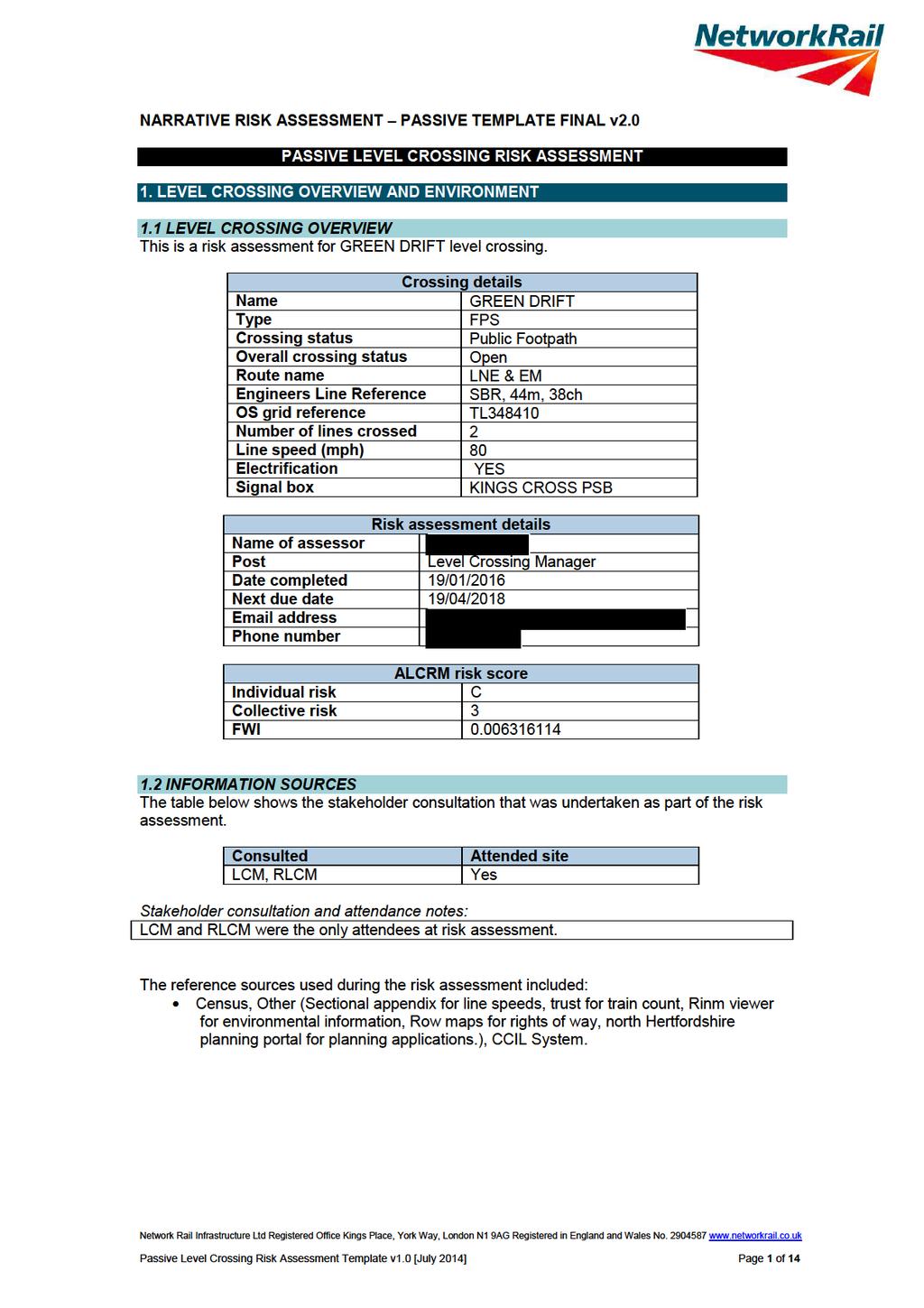
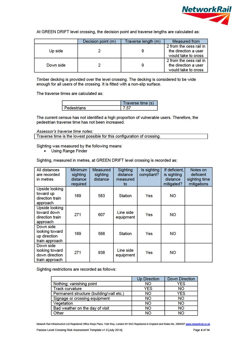
3 2. LEVEL CROSSING USAGE 2.1 RAIL The train service over GREEN DRIFT level crossing consists of passenger and freight trains. There are 154 trains per day. The highest permissible line speed of trains is 80mph. Trains are timetabled to run for 24 hours per day. Assessor s notes: This crossing is highly used as a short cut 2.2 USER CENSUS DATA A site census estimated on 19/01/2016, together with Sky high 9 day census March Produced the below results: Pedestrians 86 Pedal cyclists 9 Horses / riders 0 Animals on the hoof 0 The census applies to 100% of the year. Available information indicates that the crossing does not have a high proportion of vulnerable users. Vulnerable user observations: There were no vulnerable users observed during the risk assessment Available information indicates that the crossing does not have a high number of irregular users. Irregular user observations: There were no irregular users observed during the risk assessment Information gathered indicates that GREEN DRIFT level crossing does not have a high number of users during the night or at dusk. Site visit night / dusk user observations: 20% usage during night time Assessor s general census notes: Average census result from a site census estimated on 19/01/2016 and a 9 day census carried out by Sky High, March Every 9 day census is checked against a site census carried out at the time of any subsequent risk assessment. Any major differences found between the site census and a 9 day census (older than three years) will require a new 9 day census to be requested. 2.3 USER CENSUS RESULTS ALCRM calculates usage of the crossing to be 0 road vehicles and 95 pedestrians and cyclists per day. 3. RISK OF USE 3.1 SIGHTING AND TRAVERSE Network Rail Infrastructure Ltd Registered Office Kings Place, York Way, London N1 9AG Registered in England and Wales No Passive Level Crossing Risk Assessment Template v1.0 [July 2014] Page 3 of 14
4
5 There are no known obstructions that could make it difficult for users to see approaching trains. There are no known issues with foliage, fog or other issues that might impair visibility of the crossing, crossing equipment or approaching trains. Actions to improve sighting have not been identified. Assessor s improving sighting and decision point notes Vegetation management is essential for sighting Assessor s general sighting and traverse notes: Sighting compliant, regular vegetation management is essential EVALUATION OF MITIGATIONS 3.3 CROSSING APPROACHES The signs at GREEN DRIFT level crossing are located on the direct route a user would take over the level crossing; they are positioned so that they are clearly visible to users taking a direct route over the level crossing. The visibility of the signs is reduced at night or at dusk. The approaches to the crossing within the boundary fence are not considered to be steep, slippery or present a tripping hazard to users. Assessor s notes: Two stiles before crossing then straight. There are adjacent sources of light or noise that could affect a users ability to see or hear approaching trains. Assessor s general crossing approach notes: The crossing is located between a highly populated residential area to the south and large industrial area to the north. The signs are unlit but would be clearly visible with an alternative light source. The close proximity of the industrial area brings various noises clearly audible at the crossing. 3.4 AT THE CROSSING ANOTHER TRAIN COMING RISK Trains are sometimes known to pass each other at this crossing. Assessor s another train coming notes: Trains are sometimes known to pass each other at this crossing. 3.5 INCIDENT HISTORY A level crossing safety event has been known to occur at GREEN DRIFT level crossing in the last twelve months. Assessor s incident history notes: During summer times children often play about at this crossing, in recent times trains have been cautioned over crossing. Network Rail Infrastructure Ltd Registered Office Kings Place, York Way, London N1 9AG Registered in England and Wales No Passive Level Crossing Risk Assessment Template v1.0 [July 2014] Page 5 of 14
6
7
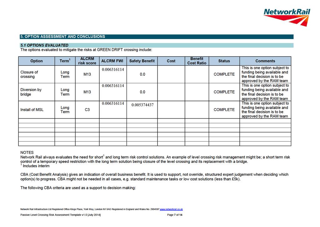
8 a. benefit to cost ratio is 1: positive safety and business benefit established; b. benefit to cost ratio is between 0.99 and 0.5: reasonable safety and business benefit established where costs are not grossly disproportionate against the safety benefit; and c. Benefit to cost ratio is between 0.49 and 0.0: weak safety and business benefit established. Network Rail Infrastructure Ltd Registered Office Kings Place, York Way, London N1 9AG Registered in England and Wales No Passive Level Crossing Risk Assessment Template v1.0 [July 2014] Page 8 of 14

9 5.2 CONCLUSIONS Assessor s notes: Green Drift footpath Crossing Green Drift footpath is near Royston town it leads from a housing estate to industrials and back to the town centre. The hazards associated with this crossing are: Interface between crossing users and trains. Potential misuse by crossing users. Frequency of trains. The current risk controls in place to mitigate against these hazards are: Stiles on both side of crossing. Signage on how to use crossing, Stop-Look-Listen. Decking with non-slip. Proposed additional mitigation plans are: There is no additional mitigation plans for this crossing at this present time. Long term plans for this crossing are: Close this crossing via bridge. Long term: (re-signalling, renewals, line speed increase and environmental changes) are: There are no long term re-signalling, renewals, line speed increase and environmental changes currently planned for this crossing. Options: Closure of this crossing by bridge is one option. This is one option subject to funding being available and the final decision is to be approved by the RAM team. Network Rail Infrastructure Ltd Registered Office Kings Place, York Way, London N1 9AG Registered in England and Wales No Passive Level Crossing Risk Assessment Template v1.0 [July 2014] Page 9 of 14
10
11
12
13
14
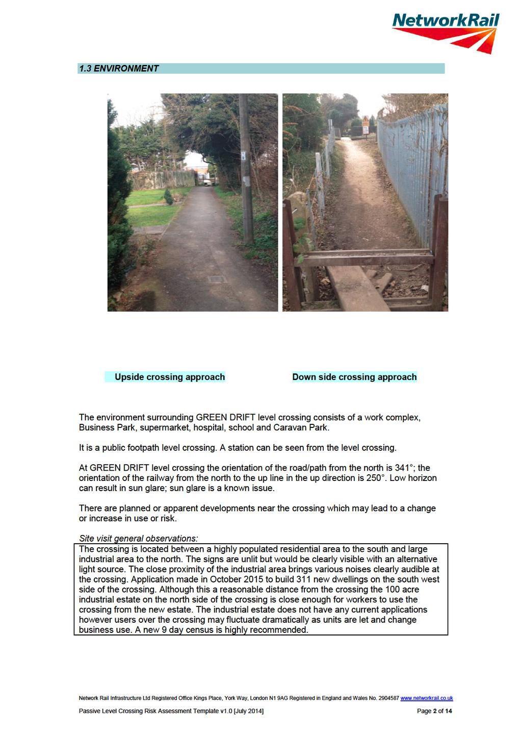
There are no planned or apparent developments near the crossing which may lead to a change or increase in use or risk.
 1.3 ENVIRONMENT Up side crossing approach Down side crossing approach It is a domestic level crossing which is located at the station. At CROWLE STATION level crossing the orientation of the road/path
The environment surrounding Gipsy Lane FPG level crossing consists of town or village etc on one side of the line.
 1.3 ENVIRONMENT Up side crossing approach Down side crossing approach The environment surrounding Gipsy Lane FPG level crossing consists of town or village etc on one side of the line. It is a public footpath
Harts Drove UWCM level crossing provides Access to worksite / leisure area from facility.
 Up side crossing approach Down side crossing approach Harts Drove UWCM level crossing provides Access to worksite / leisure area from facility. It is an occupation level crossing which is located on Aliwal
Thank you for your of 1st June You requested the following information:
 By email: d Network Rail Freedom of Information The Quadrant Elder Gate Milton Keynes MK9 1EN T 01908 782405 E FOI@networkrail.co.uk 26 th June 2018 Dear, Information request Reference number: FOI2018/00689
Level Crossing Risk Assessment Polegate MCB
 Level Crossing Risk Assessment Polegate MCB Polegate MCB Level Crossing Risk Assessment 1 CONTENTS 1 INTRODUCTION 3 1.1 Background 3 1.2 Reason for the risk assessment 3 2 DESCRIPTION OF THE SITE 4 2.1
Felixstowe Branch Line FAQ
 Felixstowe Branch Line FAQ How was the location of the track doubling work decided? We undertook a study to identify how to meet the freight demand along the Felixstowe Branch Line by modelling the route.
Appendix 6 Fulbourn Greenway Review
 Appendix 6 Fulbourn Greenway Review Nigel Brigham & Associates A report for 1 Introduction This report is based on fieldwork carried out in 2016 to review the Greenway network around Cambridge as shown
Passive Level Crossings. Crossings where users are in control of their actions
 1 Passive Level Crossings Crossings where users are in control of their actions / Level Crossings in your area Over 6,300 level crossings in the UK LNE & EM Route 1,870 level crossings. Gateshead Skiff
Calgary River Access Strategy Priority Sites and Proposed Funding
 Calgary River Access Strategy Priority Sites and Proposed Funding CPS2017-0103 ATTACHMENT 2 A total of $7,660,000 (Class 5 estimate) is required to implement all sites within the Calgary River Access Strategy;
TRANSPORT AND WORKS ACT 1992 THE TRANSPORT AND WORKS (INQUIRIES PROCEDURE) RULES 2004 THE NETWORK RAIL (SUFFOLK LEVEL CROSSING REDUCTION) ORDER
 RULES 2004 THE NETWORK RAIL (SUFFOLK LEVEL CROSSING REDUCTION) ORDER") Suffolk (Level Crossing Reduction) Order Statement of Case TRANSPORT AND WORKS ACT 992 THE TRANSPORT AND WORKS (INQUIRIES PROCEDURE) RULES 2004 THE NETWORK RAIL (SUFFOLK LEVEL CROSSING REDUCTION) ORDER
Suffolk (Level Crossing Reduction) Order Statement of Case TRANSPORT AND WORKS ACT 992 THE TRANSPORT AND WORKS (INQUIRIES PROCEDURE) RULES 2004 THE NETWORK RAIL (SUFFOLK LEVEL CROSSING REDUCTION) ORDER
All queries and paragraph references, as set out in red below, relate to Mark Brunnen s Proof of Evidence (NR27/1).
.") This note summarises the information requested by Cambridgeshire County Council at Public Inquiry for the Network Rail (Cambridgeshire Level Crossing Reduction) Order, together with Network Rail s responses.
This note summarises the information requested by Cambridgeshire County Council at Public Inquiry for the Network Rail (Cambridgeshire Level Crossing Reduction) Order, together with Network Rail s responses.
Appendix 9 Melbourn Greenway Review
 Appendix 9 Melbourn Greenway Review Nigel Brigham & Associates A report for 1 Introduction This report is based on fieldwork carried out in 2016 to review the Greenway network around Cambridge as shown
Railfuture East Anglia Whittlesford Parkway station audit
 Railfuture East Anglia Whittlesford Parkway station audit Introduction and summary of findings This report details the findings of a station audit carried out by members of Railfuture East Anglia Branch
The pilot and airline operator s perspective on runway incursion hazards and mitigation options. Session 3 Presentation 1
 The pilot and airline operator s perspective on runway incursion hazards and mitigation options Session 3 Presentation 1 Operational Hazards Workload issues during taxiing that can result in a loss of
Gold Coast. Rapid Transit. Chapter twelve Social impact. Chapter content
 Gold Coast Rapid Transit Chapter twelve Social impact Chapter content Social impact assessment process...235 Existing community profile...237 Consultation...238 Social impacts and mitigation strategies...239
Better Towpaths for Everyone. A national policy for sharing towpaths
 Better Towpaths for Everyone A national policy for sharing towpaths Contents Foreword 2 Introduction 3 Consultation 3 Principles of towpath use 4 Better infrastructure 5 Towpath Design Guide 5 Better signs
Railway Level Crossings. Keeping you Safe! Information Pack
 1 Railway Level Crossings Keeping you Safe! Information Pack Railway Level Crossings Keeping you Safe 2 Contents Introduction 3 The golden rules 4 Types of level crossing 5 Boom gates and flashing lights
Transport Assessment Appendix M: Avonmouth Impacts
 Portishead Branch Line (MetroWest Phase 1) Environmental Impact Assessment Transport Assessment Appendix M: Avonmouth Impacts Prepared for West of England Councils December 2016 1 The Square Temple Quay
The Light Rail System Safety & Grade Crossing Equipment
 The Light Rail System Safety & Grade Crossing Equipment A Peer Review Provided by the American Public Transportation Association (APTA) Presented by: Mark Benedict, Director, Light Rail Operations and
Saighton Camp, Chester. Technical Note: Impact of Boughton Heath S278 Works upon the operation of the Local Highway Network
 Technical Note: Impact of Boughton Heath S278 Works July 2013 SAIGHTON CAMP CHESTER COMMERCIAL ESTATES GROUP TECHNICAL NOTE: IMPACT OF BOUGHTON HEATH S278 WORKS UPON THE OPERATION OF THE LOCAL HIGHWAY
IOW Ramblers Submission Paper to the Sept 2016 ROW Improvement Plan Consultation.
 IOW Ramblers Submission Paper to the Sept 2016 ROW Improvement Plan Consultation. The current Island Rights of Way Improvement Plan is a comprehensive document and much of its content is still relevant
M621. Junctions 1 to 7 Improvement scheme. Share your views
 M621 Junctions 1 to 7 Improvement scheme Share your views Investing in your roads Every road user wants less congested roads to enable swift, safe, comfortable and informed travel. On behalf of the government,
The Network Rail (Suffolk Level Crossing Reduction) Order
 Order") Aidan Dunn Interim Director of Resource Management Suffolk County Council Endeavour House 8 Russell Road Ipswich IP1 2BX Network Rail James Forbes House 27 Great Suffolk St London SE1 0NS 27 July 2017
Aidan Dunn Interim Director of Resource Management Suffolk County Council Endeavour House 8 Russell Road Ipswich IP1 2BX Network Rail James Forbes House 27 Great Suffolk St London SE1 0NS 27 July 2017
First Steps Towards Sustainable Operation of Road Tunnels. George Mavroyeni Australia
 First Steps Towards Sustainable Operation of Road Tunnels George Mavroyeni Australia Road Tunnel Operations First steps towards sustainable operation of road tunnels Available on PIARC website here PIARC
Unlocking our Coastal Heritage Strand 2 - Watermouth Bay, nr Ilfracombe
 Unlocking our Coastal Heritage Strand 2 - Watermouth Bay, nr Ilfracombe In order to provide a safe route for users of the South West Coast Path this project realigned 265m of the A399 coast road to incorporate
Airdrie - Bathgate Railway and Linked Improvements Bill. Environmental Statement Page 1
 Environmental Statement Page 1 1.0 INTRODUCTION 1.1 The Scheme Proposal The scheme proposals are to re-open the Airdrie to Bathgate section of the former Bathgate and Coatbridge Railway (Monklands Railway)
Queen s Circus Roundabout
 Stage 2 Road Safety Audit Ref: 1128-RSA-01 Prepared for: Steer Davies Gleave By: Capital Traffic Prepared by: Checked by: Approved by: Andy Haunton, Audit Team Leader Jonathan Thompson, Audit Team Member
Train Stations are not just arrival and departure locations
 Train Stations are not just arrival and departure locations The Railway Study Association Mike Goggin 31 October 2017 Contents Introduction to Steer Davies Gleave The Passenger The Neighbour & Non-Traveller
THE PROPOSED NETWORK RAIL (ESSEX AND OTHERS LEVEL CROSSING REDUCTION) ORDER DEPARTMENT FOR TRANSPORT REFERENCE: TWA/17/APP/05
 ORDER DEPARTMENT FOR TRANSPORT REFERENCE: TWA/17/APP/05") OBJ/148/ W 031 E20 SNIVELLERS THE PROPOSED NETWORK RAIL (ESSEX AND OTHERS LEVEL CROSSING REDUCTION) ORDER PUBLIC INQUIRY, 18 OCTOBER 2017 DEPARTMENT FOR TRANSPORT REFERENCE: TWA/17/APP/05 OBJECTION BY
OBJ/148/ W 031 E20 SNIVELLERS THE PROPOSED NETWORK RAIL (ESSEX AND OTHERS LEVEL CROSSING REDUCTION) ORDER PUBLIC INQUIRY, 18 OCTOBER 2017 DEPARTMENT FOR TRANSPORT REFERENCE: TWA/17/APP/05 OBJECTION BY
Chapter 8 Route Window NE7 Chadwell Heath station. Transport for London
 Chapter 8 Route Window NE7 Chadwell Heath station Transport CHADWELL HEATH STATION 8 Route Window NE7 Chadwell Heath station Baseline conditions 8.6 This route window lies within the London Boroughs of
Appendix A: Summary of findings drawn from an analysis of responses to the questionnaire issued to all households in Trimley St Martin
 Transport and Works Act 1992 The Network Rail (Felixstowe Branch Line Improvements Level Crossing Closure) Order Trimley St Martin Parish Council Statement of Case The statement of Case of the Parish Council
Report to: Greater Cambridge Partnership Joint Assembly 18 January A10 Foxton level crossing bypass and travel hub
 Report to: Greater Cambridge Partnership Joint Assembly 18 January 2018 Lead officer: Chris Tunstall GCP Director of Transport A10 Foxton level crossing bypass and travel hub 1. Purpose 1.1 The list of
Recreational Carrying Capacity
 9 th Annual Caribbean Sustainable Tourism Conference Recreational Carrying Capacity Graham C Barrow What is Recreational Carrying Capacity? It s not about fixing absolute numbers of visitors/tourists that
Road-Rail Interface Safety
 Road-Rail Interface Safety A guide to RSSB research in Road-Rail Interface Safety April 2011 RSSB 1 Road-Rail interface safety research 2 RSSB The photographs in the guide appear courtesy of ATOC/Paul
DAVA WAY. Notes on multi-use access
 DAVA WAY Notes on multi-use access The Dava Way is a 24 mile (38km) waymarked long distance route based largely on the dismantled Highland Railway Line between Forres, near the Moray Coast in north-east
NivoTest : a personal assistant for avalanche risk assessment
 NivoTest : a personal assistant for avalanche risk assessment R.Bolognesi METEISK, CP 993, CH-1951 SION. www.meteorisk.com Introduction About avalanche risk Every mountaineer knows that avalanche hazard
HIGHWAY RAIL GRADE CROSSING CONSOLIDATION PROGRAM
 HIGHWAY RAIL GRADE CROSSING CONSOLIDATION PROGRAM To decrease unnecessary train traffic exposure to life and property, promote public safety, and improve traffic conditions, the Texas Department of Transportation
Level Crossings Design and Installation
 Discipline: Engineering (Track & Civil) Category: Standard Level Crossings Design and Installation ETD-16-02 Applicability New South Wales CRIA (NSW CRN) Primary Source ARTC NSW Standard XDS 02 Document
Management Standards for Recreational Trails
 Management Standards for Recreational Trails First edition October 2008 The National Trails Office The National Trails Office (NTO) is a programme run by the Irish Sports Council building on the work of
Level Crossing Interface Requirements
 Level Crossing Interface Synopsis This document mandates the control, command and signalling requirements for level crossing equipment, so that level crossing functionality is compatible with infrastructure
Summary Delivery Plan Control Period 4 Delivery Plan More trains, more seats. Better journeys
 Summary Delivery Plan Control Period 4 Delivery Plan 2009 More trains, more seats Better journeys Network Rail aims to deliver a railway fit for the 21st century. Over the next five years (Control Period
Riverside Heights, Norwich. Travel Plan
 RIVERSIDE HEIGHTS, NORWICH Client: Engineer: Taylor Wimpey East Anglia Create Consulting Engineers Limited Hungate House Princes Street Norwich Norfolk NR3 1AZ Tel: 08454507908 Email: enquiries@createconsultingengineers.co.uk
Lake Erie Commerce Center Traffic Analysis
 LOCATION: East of NYS Route 5 at Bayview Road Town of Hamburg Erie County, New York PREPARED BY: Wendel Companies 140 John James Audubon Parkway Suite 200 Amherst, New York 14228 January 2012 i ii Table
Document Control Identification. Document History. Authorisation. Rail Safety Manager Brookfield Rail
 Document Control Identification Document History Authorisation Rail Safety Manager Brookfield Rail Table of Contents Glossary for this Rule... 4... 6... 6... 6... 6... 8... 8... 8... 9... 10... 10 Glossary
FAQS and Code of Conduct for use under the Tamar Trails heading on the Tamar Valley AONB and Tamar Trails websites: Tamar Trails FAQs
 FAQS and Code of Conduct for use under the Tamar Trails heading on the Tamar Valley AONB and Tamar Trails websites: Tamar Trails FAQs What are the Tamar Trails? The Tamar Trails are 25km of new and improved
E40. Temporary activities
 E40. Temporary activities E40.1. Background Temporary activities contribute to Auckland's vibrancy and to the social, cultural and economic well-being of communities. Temporary activities also enable filming
Chicago St. Louis High-Speed Rail. Braidwood Construction. Local Officials Briefing August 7, 2014
 Chicago St. Louis High-Speed Rail Braidwood Construction Local Officials Briefing August 7, 2014 1 Chicago-St. Louis Corridor Goals and Benefits» Reduction in travel time by about an hour» Enhanced reliability»
ACCESS STATEMENT LAKE VYRNWY HOTEL & SPA
 ACCESS STATEMENT LAKE VYRNWY HOTEL & SPA August 2014 Access Statement for Lake Vyrnwy Hotel & Spa Overview: On the site at Lake Vyrnwy is a 52-bedroom Hotel, a formal Restaurant open to both staying guests
SAMTRANS TITLE VI STANDARDS AND POLICIES
 SAMTRANS TITLE VI STANDARDS AND POLICIES Adopted March 13, 2013 Federal Title VI requirements of the Civil Rights Act of 1964 were recently updated by the Federal Transit Administration (FTA) and now require
FILLED WITH FACTS & ACTIVITIES. e s. t o. e f. f l BE SAFE, STAY ALIVE!
 FILLED WITH FACTS & ACTIVITIES A an f l us ef e s r u ul guide to kee ping yo n the roa d. o e f a ers s h t o d BE SAFE, STAY ALIVE! Safe Walking The Green Cross Code Crossing Safely Road Signs & Signals
Speed control humps - Scotland, England and Wales
 Traffic Advisory Leaflet 3/91 September 1991 Speed control humps - Scotland, England and Wales Introduction Road humps are an extremely effective means of keeping vehicle speeds low. The standard round
Abbey Chesterton bridge Questions & Answers
 Abbey Chesterton bridge Questions & Answers Please click on links below to go to individual subjects: Bridge location and access routes Timescales Bridge details and accessibility Construction compound
20mph Speed Limit Zones
 Traffic Advisory Leaflet 7/91 May 1991 20mph Speed Limit Zones Summary This leaflet illustrates the main steps in the procedures for the implementation of 20mph zones. It provides brief details on: the
Update on the Thameslink programme
 A picture of the National Audit Office logo Report by the Comptroller and Auditor General Department for Transport Update on the Thameslink programme HC 413 SESSION 2017 2019 23 NOVEMBER 2017 4 Key facts
Non-technical summary
 Introduction NTS1 NTS2 NTS3 Troika Developments Ltd (Troika) has submitted a planning application to Bournemouth Borough Council (BBC) for an extension of time to implement planning permission 7/2004/16450/G,
GK/GN0692. Guidance on Level Crossing Interface Requirements. Rail Industry Guidance Note for GK/RT0192. Published by
 GN Published by Block 2 Angel Square 1 Torrens Street London EC1V 1NY Copyright 2012 Rail Safety and Standards Board Limited GK/GN0692 Issue Two: December 2012 Rail Industry Guidance Note for GK/RT0192
Proposed Arthurs Point Special Housing Area. Housing Accords and Special Housing Areas Act Expression of Interest
 Proposed Arthurs Point Special Housing Area Housing Accords and Special Housing Areas Act 2013 Expression of Interest 1.0 APPLICANT The applicant for the proposed Arthurs Point Special Housing Area is
PUBLIC INQUIRY APPLICATION BY NEWTWORK RAIL UNDER TRANSPORT AND WORKS ACT 1992 PROPOSED NETWORK RAIL SUFFOLK LEVEL CROSSING REDUCTION ORDER
 PUBLIC INQUIRY APPLICATION BY NEWTWORK RAIL UNDER TRANSPORT AND WORKS ACT 1992 PROPOSED NETWORK RAIL SUFFOLK LEVEL CROSSING REDUCTION ORDER OBJ/27-FOREST HEATH DISTRICT COUNCIL PROOF OF EVIDENCE S22 Weatherby
Snowmobile Trail Signing REF: DNR Trail Signing Handbook
 AWSC FALL WORKSHOP TRAIL SIGNING & MAINTENANCE NOVEMBER 5, 2011 Workshop presenters: Larry Erickson, AWSC Trails Committee Chairman, Iron County Director Dave Peterson, Langlade County Director Snowmobile
WEST HIGHLAND WAY Notes on multi-use access
 WEST HIGHLAND WAY Notes on multi-use access The West Highland Way was one of Scotland s four original long distance routes. Now one of Scotland s Great Trails, it is renowned world-wide for the spectacular
London City Airport. 43 years
 ACCIDENT Aircraft Type and Registration: No & Type of Engines: Dassault Falcon 7X, VQ-BSO 3 Pratt & Whitney Canada PW307A engines Year of Manufacture: 2009 (Serial no: 64) Date & Time (UTC): Location:
THRESHOLD GUIDELINES FOR AVALANCHE SAFETY MEASURES
 BRITISH COLUMBIA MINISTRY OF TRANSPORTATION & INFRASTRUCTURE AVALANCHE & WEATHER PROGRAMS THRESHOLD GUIDELINES FOR AVALANCHE SAFETY MEASURES British Columbia Ministry of Transportation & Infrastructure
Hospital Link Project Project Update Winter 2018
 Hospital Link Project Project Update Winter 2018 General The project provides a link from Riverside Drive and the Transitway to the Hospital Link Road. Construction of the Hospital Link facility is open
Sainsburys Store, Mere Green Road, Sutton Coldfield, Birmingham, B75 5BT
 Committee Date: 7/0/013 Application Number: 013/04/PA Accepted: 1/04/013 Application Type: Variation of Condition Target Date: 1/07/013 Ward: Sutton Four Oaks Sainsburys Store, Mere Green Road, Sutton
YOU! Kensal Town Towpath Public Consultation WE WANT TO HEAR FROM YOU COULD WIN. Friday 21st December 2012 & Friday 8th February 2013
 London s greatest park, the historic canals and rivers, provide a cherished haven for people and wildlife. They are free for everyone to use and provide a welcome relief from busy city streets. We d like
The Future of Street Lighting in Leeds November 2017 to January 2018 Public Consultation Document
 The Future of Street Lighting in Leeds November 2017 to January 2018 Public Consultation Document Should we turn off more street lights between midnight and 5:30 am? If so, how should we decide which ones
CHAPTER ONE LITERATURE REVIEW
 CHAPTER ONE LITERATURE REVIEW LITERATURE REVIEW This chapter summarizes the most recently published community impact studies and articles that relate to multiuse trails. The review focuses on publications
Compliance inspection following a fatality at level crossing XM096,
 Compliance inspection following a fatality at level crossing XM096, 2 September 2010 Issue Prepared by Checked by Issue date First draft MB DC, GB 25/11/10 Second Draft AB GB 21/02/11 Draft for Comment
The case for a local rail station. At Great Blakenham, Suffolk.
 The case for a local rail station At Great Blakenham, Suffolk. The London to Norwich (Great Eastern) main rail line passes through Great Blakenham in Suffolk, a village which adjoins Claydon and Barham.
Laxon Terrace - Sarawia. Click to add title. Street Rail Level Crossing. Public Forum. December
 Laxon Terrace - Sarawia Click to add title Street Rail Level Crossing Public Forum December 2012 www.aucklandtransport.govt.nz Overview of Presentation Objectives and Reasons for Separation Project Background
Cabinet. The Future of Wareham Foot Level Crossing. Date of Meeting 24 February 2016
 Page 1 The Future of Wareham Foot Level Crossing Cabinet Date of Meeting 24 February 2016 Cabinet Member(s) Peter Finney Cabinet Member for Environment Colin Jamieson - Cabinet Member for Economy and Growth
Flow Stand Up Paddle Board Parkway Plan Analysis
 Regional Parks Department Jeffrey R. Leatherman, Director County of Sacramento Divisions Administration Golf Leisure Services Maintenance Rangers Therapeutic Recreation Services Flow Stand Up Paddle Board
Policy Railway crossings
 Policy Railway crossings Title of the document National Rail Safety Regulator Page1of12 Document reference number: A453375 Version No. Approved by Publication date 1.0 Chief Executive 24 June 2016 1.1
3. COLTA / HUGA CONNECTIONS - PRELIMINARY
 9 3. COLTA / HUGA CONNECTIONS - PRELIMINARY 3.1 COLTA The Chain of Lakes Trail Association (COLTA) trail, formerly identified as the Chester Spur Line, was completed and opened for use in June 2011. The
Survey of Littleton Down
 Survey of Littleton Down 05 November 2014 The Team: John and Jenny Barnard 1) Introduction Littleton Down (Hill Number 2911, Section 42, OS 1:50000 Map 197, OS 1:25000 Map 121, Grid Ref. SU941150) is listed
Chapter 4 Route Window NE3 Manor Park station. Transport for London
 Chapter 4 Route Window NE3 Manor Park station MANOR PARK STATION 4 Route Window NE3 Manor Park station 4.7 Highway access to Manor Park station is very good. A117 Station Road connects with A116 to the
East Midlands Airport - Past, Present and Future Introduction The History of East Midlands Airport (EMA) Fig. 1 - RAF Castle Donnington Layout -1945
 Fig. 1 - RAF Castle Donnington Layout -1945") East Midlands Airport - Past, Present and Future by John Froggatt, Cargo & Commercial Bid Director, East Midlands Airport 1. Introduction John has been employed at East Midlands Airport for the last 29
East Midlands Airport - Past, Present and Future by John Froggatt, Cargo & Commercial Bid Director, East Midlands Airport 1. Introduction John has been employed at East Midlands Airport for the last 29
FINCH HYDRO CORRIDOR TRAIL PROJECT
 FINCH HYDRO CORRIDOR TRAIL PROJECT Pharmacy Avenue to Birchmount Road January 29 th, 2018 L Amoreaux Community Centre (2000 McNicoll Avenue) 1 Purpose of Drop In Event The purpose of today s drop-in event
Provincial Railway Technical Standards
 GENERAL: INDEX: The standards and requirements listed in this document are intended for use on provincially regulated railway public grade crossings. These standards are considered the minimum requirements
LANCASTER AIRPORT DRIVER TRAINING PROGRAM
 LANCASTER AIRPORT DRIVER TRAINING PROGRAM INTRODUCTION 1. Airfield Driving Basics 2. Movement / Non-Movement Area 3. Airfield Signs, Markings & Lighting 4. Airfield Communications 5. Aviation Phonetics
MPRB: Southwest LRT Community Advisory Committee Issues and Outcomes by Location Current to: 12 November 2010
 MPRB: Southwest LRT Community Advisory Committee Issues and Outcomes by Location Current to: 12 November 2010 This is a compilation of issues and outcomes identified by the CAC. It is a work in progress,
SOUTH INTERCHANGE AREA
 Santaquin City General Plan 1 Location and Characteristics The South Interchange Area of Santaquin is located west of Interstate 15 and south of 500 South (Figure 1). It includes properties already annexed
Green Fields Leppington
 Green Fields Leppington CONNTENTS 1.0 URBAN GROWTH - SYDNEY 2.0 MACRO CONTEXT 3.0 LOCAL ENVIRONMENTAL PLAN - LEPPINGTON 4.0 CONCEPT 5.0 GREEN ROOFS 6.0 APARTMENT REALISATION SCHEDULE 7.0 INFRASTRUCTURE
PLANNING STATEMENT FORMER HSBC BANK, 18 HIGH STREET, AMESBURY
 PLANNING STATEMENT FORMER HSBC BANK, 18 HIGH STREET, AMESBURY 21 Dec 17 Introduction Amesbury has a vibrant nightlife with three public houses, two hotel bars and a nightclub within the town centre as
Rule Governing the Designation and Establishment of All-Terrain Vehicle Use Trails on State Land
 Rule Governing the Designation and Establishment of All-Terrain Vehicle Use Trails on State Land 1.0 Authority 1.1 This rule is promulgated pursuant to 23 V.S.A. 3506. Section 3506 (b)(4) states that an
AGENDA ITEM 5 D WAKULLA ENVIRONMENTAL INSTITUTE (WEI) TRAIL FEASIBILITY STUDY
 TRAIL FEASIBILITY STUDY") March 19, 2018 AGENDA ITEM 5 D WAKULLA ENVIRONMENTAL INSTITUTE (WEI) TRAIL FEASIBILITY STUDY TYPE OF ITEM: Action STATEMENT OF ISSUE The Wakulla Environmental Institute (WEI) Trail is one of several trails
March 19, 2018 AGENDA ITEM 5 D WAKULLA ENVIRONMENTAL INSTITUTE (WEI) TRAIL FEASIBILITY STUDY TYPE OF ITEM: Action STATEMENT OF ISSUE The Wakulla Environmental Institute (WEI) Trail is one of several trails
Appendix L Technical Memorandum Aesthetics
 Technical Memorandum Aesthetics 1.0 AESTHETICS This section provides a discussion of the aesthetic resources in the vicinity of ARTIC. Aesthetics pertain to the elements that make a certain view pleasing
IC Chapter 7.7. Railroad Grade Crossings Fund
 IC 8-6-7.7 Chapter 7.7. Railroad Grade Crossings Fund IC 8-6-7.7-1 "Grade crossing" Sec. 1. The term "grade crossing" as used in this chapter means a crossing of any railroad and any public highway, street
Uniclass L534+L212. August home zones. paving PRECAST CONCRETE PAVING SOLUTIONS FOR TODAY S RESIDENTIAL STREET ENVIRONMENTS.
 August 2005 Uniclass L534+L212 paving home zones PRECAST CONCRETE PAVING SOLUTIONS FOR TODAY S RESIDENTIAL STREET ENVIRONMENTS www.paving.org.uk Home Zone Principles Home Zones are residential streets
Figure 1: Little Dry Creek Trail Crossing
 Figure 1: Little Dry Creek Trail Crossing Figure 2: Little Dry Creek Trail Crossing Northwest Rail Environmental Evaluation Temporary Trail Detour Concurrence Form Adams County, Little Dry Creek Trail
Trigger Point Justification Note 30 th August 2013
 1. Introduction Trigger Point Justification Note 30 th August 2013 DCC constructed a highway assignment model of Tiverton and the surrounding area and this suggested that in pure capacity terms, up to
TRANSPORT AND WORKS ACT Proof of Evidence. Andrew Wright Planning and Design Manager Taylor Wimpey East Anglia
 TRANSPORT AND WORKS ACT 1992 Proof of Evidence Andrew Wright Planning and Design Manager Taylor Wimpey East Anglia The Network Rail (Suffolk Level Crossing Reduction Order) Site at Elmswell Development
Airport Planning Area
 PLANNING AREA POLICIES l AIRPORT Airport Planning Area LOCATION AND CONTEXT The Airport Planning Area ( Airport area ) is a key part of Boise s economy and transportation network; it features a multi-purpose
HEART OF THE SOUTH WEST STUDY ECONOMIC APPRAISAL OF RAIL NETWORK UPGRADE PROPOSALS
 HEART OF THE SOUTH WEST STUDY ECONOMIC APPRAISAL OF RAIL NETWORK UPGRADE PROPOSALS MAY, 2016 HEART OF THE SOUTH WEST STUDY ECONOMIC APPRAISAL OF RAIL NETWORK UPGRADE PROPOSALS Type of document (Final)
ADVICE ON Cattle Grids
 ADVICE ON 2 Definition A cattle grid, for highway purposes, is a device designed to prevent the passage of animals, or animals of any particular description, but to allow the passage of all or some other
CONSULTATION ON ISSUES AFFECTING PASSENGERS ACCESS TO UK AIRPORTS A REVIEW OF SURFACE ACCESS. Response by Newcastle International Airport Ltd
 CONSULTATION ON ISSUES AFFECTING PASSENGERS ACCESS TO UK AIRPORTS 1. Introduction A REVIEW OF SURFACE ACCESS Response by Newcastle International Airport Ltd Newcastle is the largest airport in the North
2. STAKEHOLDER FEEDBACK // What We Heard
 1. QUARRY ROAD TRAIL // Welcome to the Information Session PROJECT DESCRIPTION WHY WE ARE HERE Quarry Road Trail is a popular commuter trail and recreational area for Calgarians. 1. To report citizen feedback
General Rules for Use of Lands Managed by the. Middle Peninsula Chesapeake Bay Public Access Authority
 General Rules for Use of Lands Managed by the Middle Peninsula Chesapeake Bay Public Access Authority As a visitor to lands managed by the Middle Peninsula Chesapeake Bay Public Access Authority (PAA),
Longmont to Boulder Regional Trail Jay Road Connection DRAFT FINAL REPORT
 Longmont to Boulder Regional Trail Jay Road Connection DRAFT FINAL REPORT December 2018 Project Summary Boulder County, Colorado, in partnership with the City of Boulder, is evaluating options for multi-use
Dyke Road Cycle and Pedestrian Improvements 14/02/2014 Reference number PEDESTRIAN CROSSING AND GUARDRAILING ASSESSMENT
 14/02/2014 Reference number 102470 PEDESTRIAN CROSSING AND GUARDRAILING ASSESSMENT DYKE ROAD CYCLE AND PEDESTRIAN IMPROVEMENTS PEDESTRIAN CROSSING AND GUARDRAILING ASSESSMENT IDENTIFICATION TABLE Client/Project