Junction 9 Improvement Scheme
|
|
|
- Isaac Simon
- 5 years ago
- Views:
Transcription

1 M3 Junction 9 Improvement Scheme Registered office Bridge House, 1 Walnut Tree Close, Guildford, GU1 4LZ Highways England Company Limited registered in England and Wales number March 2018
 1256 318800 www.wsp.")
2 M3 JUNCTION 9 IMPROVEMENT SCHEME PCF STAGE 2 (OPTION SELECTION) REPORT ON PUBLIC CONSULTATION Highways England Date: March 2018 Project no: HE PIN: Prepared for: Highways England Bridge House Walnut Tree Close Guildford Surrey GU1 4LZ Mountbatten House Basing View Basingstoke RG21 4HJ Hampshire United Kingdom Tel: +44-(0) ii
3 TABLE OF CONTENTS M3 Junction 9 Improvement Scheme Executive Summary Introduction...4 Scheme Background... 4 Scheme Objectives... 4 Project Location... 4 Options Tested... 5 This Report The Consultation Approach...7 Introduction... 7 Public Consultation Objectives... 7 Approach... 7 Materials... 8 Publicity and Advertising Consultation Effectiveness...15 Introduction Public Respondents Letters and s Briefing Event and Public Information Event Attendance Record Highways England Website Visitors Response and Analysis Methodology Effectiveness of Communication Methods Travel Behaviour and Existing Issues...19 Travel Behaviour Relative to M3 junction Mode Choice v
4 Existing Concerns and Issues Views on the Proposed Option Introduction Need for Improvements to M3 junction Views on Proposed Scheme (Option 14) Rejected Options Other Comments Stakeholder Responses...29 Introduction Other Responses...35 Introduction Response Analysis Evaluation of Consultation...37 Introduction Material Usefulness Exhibition Usefulness Press and Social Media...39 Local Press Coverage Social Media Coverage Press Release Next steps...43 Introduction Key Emerging Themes Alternatives Proposed vi
5 TABLES Table 2-1: Communication materials and channels...8 Table 2-2: Schedule of public information events Table 2-3: Deposit point locations Table 3-1: Consultation responses Table 3-2: Public consultation attendance Table 3-3: Website visitor figures Table 5-1: Main reasons given for supporting Option Table 5-2: Issues raised regarding Option Table 5-3: Further suggestions made by respondents Table 6-1: Summary of question and answer session at the Councillors Briefing Event.. 29 Table 6-2: Summary of main questions at the NMU Briefing Event Table 6-3: Other issues raised at the NMU Briefing Event Table 6-4: Summary of Question and Answer session at the Business Briefing Event Table 7-1: Summary of correspondence response FIGURES Figure 1-1: Scheme location relative to the strategic road network...5 Figure 2-1: Letter distribution area...9 Figure 2-2: Screenshot of Highways England M3 junction 9 improvements consultation page Figure 3-1: Communication channel awareness Figure 3-2: Respondent age profile Figure 3-3: Capacity in which responding to the consultation Figure 4-1: Trip distance and frequency of junction usage Figure 4-2: Junction usage profile by time of day and day of week Figure 4-3: Modal use at M3 junction Figure 4-4: Attitudes toward current junction Figure 5-1: Level of support/opposition to improve the M3 junction Figure 5-2: Opinion on whether Option 14 will meet the scheme objectives Figure 5-3: Concerns over the implementation of Option Figure 5-4: Overall levels of support/opposition for Option Figure 5-5: Understanding of rejected options Figure 8-1: Usefulness of consultation materials Figure 8-2: Level of event usefulness (n=310) Figure 9-1: Press release vii
6 APPENDICES APPENDIX A APPENDIX B APPENDIX C APPENDIX D APPENDIX E SCHEME BROCHURE SCHEME QUESTIONNAIRE PRESS ADVERTISEMENT CATCHMENT AREA OF RESPONDENTS AND EVENT ATTENDEES CODING FRAME AND FREQUENCY COUNTS OF OPEN RESPONSES viii
7 EXECUTIVE SUMMARY OVERVIEW The M3 junction 9 currently acts as a bottleneck on the local and strategic highways network and causes significant delay, especially during peak hours. It has been designated within the Roads Investment Strategy (RIS1) as one of the network improvements schemes to be undertaken. The purpose of this report is to provide a summary of the responses and feedback gathered during the non-statutory public consultation for the M3 junction 9 improvements scheme, which ran from 9 January to 19 February OPTIONS PRESENTED Several options were reviewed at Project Control Framework (PCF) Stage 1. Option 11 was rejected due to significant negative environmental impacts, whilst Option 18 was rejected as a result of not meeting the scheme objectives. Options 14, 16B and 16C were then assessed further in PCF Stage 2 after which it was decided to present Option 14 as the proposal at the public consultation. Options 16B and 16C were rejected as they were found to be an inefficient method of achieving a scheme equivalent to Option 14. These rejected options were presented along with reasons why they were rejected. Option 14 features the following improvements: It provides free-flow links between the A34 and M3 with the A34 southbound link passing under the M3 with a 60mph design speed with a three-step relaxation on horizontal geometry. Junction 9 would be rebuilt with a dumbbell roundabout layout. This option is fully compliant, minimising environmental effects while also providing higher value for money compared to Option 11. CONSULTATION ARRANGEMENTS The consultation took place over a six week period, providing interested parties the opportunity to review and comment on the proposed scheme and for local knowledge and opinions to be obtained. The consultation included five public events and four formal briefing events which allowed interested parties to ask questions of technical experts that were associated with the scheme. In addition eight local locations displayed brochures and questionnaires for the public to take and review, including two service stations on the M3 and A34 to highlight the consultation to passing motorists. Various media forms were used to advertise the scheme, the consultation events and how to express their views: A paper questionnaire was available or visiting the Highways England website to complete it online; The consultation material was distributed outside of the local advertising area; or Advertising in the local newspapers was placed in the first week of the consultation and subsequently in advance of each public information event. 1
8 25,141 letters were delivered to residential properties across Winchester and Kings Worthy along with businesses, MPs, Councillors, landowners and other stakeholders such as schools and interest groups detailing the public information events and deposit points. EFFECTIVENESS OF THE PUBLIC CONSULTATION The public information events were well attended with 830 people attending across the five events; with a further 64 councillors, non-motorised users (NMUs), businesses and landowners attending the dedicated briefing events. The website had 7031 unique visitors across the scheme and consultation pages, with an average time spent of five minutes. Overall 854 questionnaires where returned, of which 540 were online responses. A further 49 written responses and phone calls were received from stakeholders and the general public expressing their views on the proposed scheme in a free format. The majority of respondents found out about the consultation via the letter drop or by seeing the adverts in the local newspaper. RESPONSE ANALYSIS The vast majority of respondents are concerned with current congestion levels around M3 junction 9 and support Option 14 as a means of achieving the scheme objectives. An overview of the main findings is presented below: SUPPORT 96% agreed that there is a need to improve the junction. Traffic congestion is the top concern at the existing M3 junction 9 (98%) followed by road safety (92%), reliability of journey time (92%) and rat running onto local road network (86%). The majority believe Option 14 will meet the scheme objectives in terms of: reducing traffic congestion (91%); improving safety of the junction (75%); and improving facilities for pedestrians, cyclists and equestrians (66%). 85% support Option 14 to improve M3 junction 9. The majority fully understand the reasons for rejecting options 11 (60%), 16 (68%) and 18 (70%), with a further quarter partially understanding the reasons for options 11 (30%), 16 (26%) and 18 (24%). CONCERNS 87% are concerned about disruption during construction, both for motorists and cyclists A traffic management plan will be developed with local authorities to ensure that disruption is kept to a minimum. This information will be shared with the public prior to starting construction. 61% are concerned with environmental impacts of the scheme Detailed assessments will be available within the next stage as well as key mitigation and compensation measures to the local area. 58% question whether the new scheme will provide sufficient capacity to accommodate future growth in traffic As part of the next stage we will develop a more in depth traffic model and Highways England will then be able to communicate the key traffic data projections and considerations within this scheme. 2
9 50% are concerned about the impact on road safety This was focused around a key section of the junction improvement that will be addressed in subsequent stages through further design development. 35% raised concern over the land-take from the South Downs National park (SDNP) Working with SDNP to minimise impacts during next stages and provide suitable appeasement. IMPROVEMENT OPPORTUNITIES Access from junction 9 to the A33 Residents were concerned about the short distance available for them to merge onto the A34 and then move across a lane in order to use the offside diverge to the A33. Residents were also concerned about undertaking this manoeuvre with cars on the A34 travelling at 70mph and with the high Heavy Goods Vehicle (HGV) usage of the A34 making it a difficult manoeuvre. Further design will be undertaken to investigate alternative solutions which would make this a safer arrangement. The junction 9 NMU path A 4m wide path would be preferred to allow for future growth of cyclists. The path should be segregated from the junction 9 carriageway. The subways should be wide enough to provide sufficient visibility. Junction 9 to River Itchen footpath The footpath, although an improvement on the existing, should be made cycleway compliant and extended to the Cart & Horses junction on the A33. Where there are sharp turns on the footpath these should have sufficient visibility for cyclists. A34 southbound the weaving between the access from the A34 southbound to junction 9 and the M3 SB offslip was perceived to be short and should be increased. An auxiliary lane should be added to the A34 southbound link between the A33 and junction 9 diverge. The M3 underpass should be widened to 3 lanes on the A34 southbound to allow for future growth. Easton Lane to the A34/M3 northbound slip road Several members of the public suggested a dedicated free flow lane from Easton Lane to the A34/M3NB slip road due to the high proportion of HGV s accessing the trading estates on Easton Lane from the M3 and A34. A detailed investigation will be undertaken as part of the next stage to assess the possible options to address the key areas of improvement. These will be considered against key criteria including safety, traffic flow, environmental considerations and buildability before a formal solution can be provided. 3
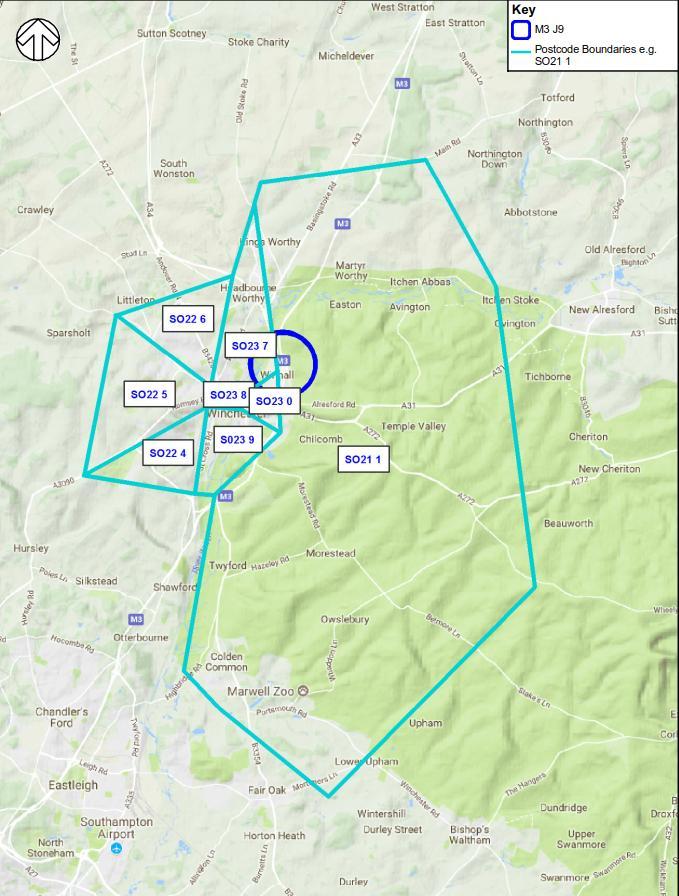
10 1. INTRODUCTION SCHEME BACKGROUND In March 2015, the Department for Transport published the Road Investment Strategy (RIS) which sets out a list of improvement schemes that will be developed by Highways England over the period The RIS outlines a long-term investment programme for England s strategic road network, with a package of committed funding available to provide: A long-term vision for the strategic road network, outlining how Highways England will create smooth, smart and sustainable roads. A multi-year investment plan that will be used to improve the network and create better roads for users. High-level objectives for the first roads period 2015 to The Road Investment Strategy for the 2015/ /20 Road Period document announced M3 junction 9 improvements with the intention to provide an upgrade to the junction to allow free movement between the A34 and M3. SCHEME OBJECTIVES The scheme has the following objectives: Supporting economic growth Unlocked development capacity for job, business and housing creation. A safe and serviceable network Safety improved as a result of a reduction in delays and queue lengths. A more free flowing network Reduced congestion and increased journey time reliability. An improved environment Potential to reduce road traffic noise and vehicle emissions through reduced congestion. The scheme shall have no net loss to biodiversity by 2020, as required by the Highways England Delivery Plan. A more accessible and integrated network Improvements at junction 9 will also include improvements for non-motorised users. The scheme will reconnect the National Cycle Network route 23 which is severed by the current junction layout. PROJECT LOCATION The scheme location of M3 junction 9 relative to the Strategic Road Network (SRN) is illustrated in Figure 1-1. The M3 junction 9 is a key strategic route interchange which connects South Hampshire and the ports of Southampton and Portsmouth with the wider sub region. It also connects the region to London via the M3, and the Midlands and the North via the A34. The A34 also provides a connection to the principal east-west corridor of the A303. 4


, providing free-flow links between the A34 and M3 (S) with the A34 southbound")
11 Figure 1-1: Scheme location relative to the strategic road network (Source: Esri, HERE, DeLorme, FAO, USGS, NGA) N A34 Kings Worthy A33 M3 A34 M3 junction 9 Winchester A31 M3 OPTIONS TESTED The following options were considered in detail, and: Option 11 - This option provides free-flow links between the A34 and M3 with the A34 southbound link passing under the M3 with a 70mph speed limit. Junction 9 would be rebuilt with a new roundabout layout. This option was rejected due to the significant negative environmental effects resulting from the size of the scheme and the negative effects on the River Itchen and surrounds as well as being low value for money. Option 14 - This is the same as PCF Stage 1 Option 14, which is a variant of WSP Option 4 (as per PCF Stage 0 report), providing free-flow links between the A34 and M3 (S) with the A34 southbound link passing under the M3. Under this option, the existing roundabout will be replaced by a dumbbell junction. Provision of free flow slips between the M3 and A34 will move the diverge / merge north of the existing M3 junction 9, meaning traffic flow under the existing junction and structures will increase significantly as it will include M3 and A34 traffic. In order to accommodate the increase in traffic it is likely that four running lanes will be required in each direction under the junction south of the merge / diverge. The current structures are not wide enough to accommodate this widening therefore a dumbbell junction with wider structures is proposed as an additional variation. 5
12 Option 16 - This is effectively a phased delivery of Option 14, and involves implementing Option 16B first and then the remainder as Option 16C to deliver the full junction improvement. Option 16B provides a free-flow for the A34 northbound, which has a 70mph design speed. The southbound A34 would still use the existing A34 through the existing junction 9 roundabout. This option is considered to facilitate potential scheme capital costs within the affordable budgets of RIS1. Option 16C would then be built five years later providing the southbound A34 free flowing link and construction of a replacement junction 9. However, after approval was given to have full funding to deliver Option 14 within the RIS1; it was no longer deemed necessary to continue with this approach of an incremental delivery. Option 18 - This option was developed, to consider a reduced cost of converting the current junction 9 layout to a roundabout with the southbound A34 running through the middle. This was considered to be affordable within the scheme budget and did not require any land take with minimum environmental impacts. This option was rejected as the option is unlikely to have a significant effect on congestion and queuing traffic on the A34 and M3. It is also likely to make queuing worse on the A272 Spitfire Link and Easton Lane. As a result this option does not meet the scheme objectives. THIS REPORT The purpose of this report is to provide a summary of the responses and feedback gathered during the non-statutory public consultation for the M3 junction 9 improvement scheme, which ran from 9 January 2018 to 19 February The report details how stakeholders and the public were informed, how the proposal was presented, the responses received from members of the public, statutory stakeholders and other bodies, and how the responses have been analysed and considered These responses will be used to help identify the Preferred Route Option and design requirements as the scheme approaches statutory public consultation and Development Consent Order application (if applicable) The report is structured as follows: Chapter 1: Introduction Chapter 2: The Consultation Approach Chapter 3:Consultation Effectiveness Chapter 4:Travel Behaviour and Existing Issues Chapter 5: Views on the Proposed Option 14 Chapter 6: Stakeholder Responses Chapter 7: Other Responses Chapter 8: Evaluation of Consultation Chapter 9: Press and Social Media Chapter 10: Next Steps 6
13 2. THE CONSULTATION APPROACH INTRODUCTION The public consultation took place over a six-week consultation period from 9 January until midnight on 19 February 2018; affording an important opportunity for Highways England to gain a better understanding of the views and expectations of local people, stakeholders, landowners, businesses, public authorities, communities and road-users The responses to the consultation will help to identify the Preferred Route Option and the design requirements that would need to be considered as the scheme progresses. PUBLIC CONSULTATION OBJECTIVES The consultation approach aimed to meet the following objectives: Provide information about the M3 junction 9 improvement scheme objectives, planning and design process, and opportunities for local community/stakeholder input. Present the junction improvement option including the perceived benefits and/or dis-benefits of the option. Ensure that the public consultation is accessible so that people understand the junction improvement option and can make informed comment. Provide sufficient opportunities for all people who may have an interest in or may be impacted by the junction improvements to provide feedback. Facilitate feedback about the scheme, specifically the level of support for the proposed option, issues and constraints related to this and rejected options, and other matters to consider when developing the scheme. APPROACH In preparation for the non-statutory public consultation, Highways England implemented a targeted Public Consultation Strategy, which clearly set out the aims of the consultation, target audiences, key messages and identified stakeholders of interest. It was important that the approach enabled stakeholders to be meaningfully and continuously involved with the scheme from an early stage. 7
14 Table 2-1: Communication materials and channels Communication Type Letters and s Brochure and questionnaire Deposit points Highways England project website Newspaper advertising Posters Highways England contact details Existing communication channels Social Media Public Information Events Briefing Events Purpose Informed residents, landowners, businesses, MP s, Councillors, key stakeholders and wider stakeholders about the public consultation. Brochure provided concise information about the proposals. Questionnaire was the main method of gathering feedback. Public consultation materials (brochures, questionnaires and posters) were made available in eight local, publicly accessible locations. Made consultation materials (brochures, questionnaires, visualisation, background information, exhibition displays) available online. Raised awareness of the consultation amongst the general public, including those from a wider area throughout the consultation period. Displayed at deposit points to advertise the public consultation. Provided in case of queries or for those requiring the information in a different format. Established communications channels (Chamber of Commerce, Local Authority distribution lists and wider stakeholder organisations including equalities groups) used to extend the consultation reach. Twitter and Facebook were used to target a computer literate audience. Provided opportunity for interested groups, local residents, landowners and businesses to view the proposals and discuss them with members of the project team. Provided opportunity for Councillors, Members of Parliament (MPs), Non-Motorised Users (NMUs), Businesses and Landowners to view the proposals and discuss them with members of the project team. MATERIALS Letters of invitation were distributed in advance of the consultation to 25,141 residential properties in the vicinity of the M3 junction 9 containing full details of the public consultation. The area of coverage is shown in Figure

15 Figure 2-1: Letter distribution area 9
16 2.4.2 Personalised letters were also sent out to the following groups to make them aware of the consultation: Landowners those whose land may be impacted by the proposed scheme (24); Businesses (51); MPs / Councillors (5 MPs, 63 Councillors); and NMUs (51). BROCHURES AND QUESTIONNAIRES A 16-page consultation brochure (Appendix A) was produced with concise information about the scheme including the scheme background, summary of the discounted options, detailed description of the proposal, the impacts and the benefits and the next stages A separate consultation questionnaire (Appendix B) was produced which sought respondents views on the existing issues, and the proposal before exploring travel behaviour and effectiveness of communication. A variety of both closed questions (where respondents select their answer from a pre-defined list) and open-ended questions (free-text format response) were used within the questionnaire. It was also available as an online survey at: BACKGROUND REPORTS In addition to the consultation brochure, two background reports were made available on the project website and at the exhibitions, as follows: Environmental Study Report Technical Appraisal Report CONSULTATION EVENTS Prior to the consultation events, all consultant and Highways England representatives attended a full briefing providing: An outline of event operation, timings and venue overview (access, facilities etc.); A briefing on health and safety operations; Details of the scheme options and appropriate technical leads; and A walk-through of the brochure, questionnaire, display material and other options for feedback collection Each event was hosted by the Highways England and WSP project team, including experts on traffic modelling, environment, land ownership, and highways to ensure queries during the events could be properly addressed. The events held during the consultation period were as follows: One to one meetings with the affected landowners (for landowners impacted by possible land acquisition); Political briefing event (for MPs, county, city and parish/borough councillors); NMU briefing event; Business briefing event; Landowner briefing event (for landowners impacted by environmental surveys); and Five public information events. 10
17 2.4.8 In addition, unstaffed display stands with brochures and questionnaires were provided in eight locations throughout the six week consultation period, with regular contact maintained to ensure they were adequately stocked with materials throughout the period Hearing loops and large print versions of the brochure were also made available to enhance the accessibility for individuals with hearing or sight difficulties. EXHIBITION BANNERS The public consultation pull up banners were displayed at each briefing and public information event. They presented key information about the scheme including the objectives, background, options, environmental constraints, results of the assessments, the consultation process, and next stages. VISUALISATION A visual representation of the proposed Option 14 was produced and made available to view on Highways England scheme website. The film was also displayed on television screens on a continual loop at each briefing and public information event, with experts available to answer questions as needed. POLITICAL BRIEFING A political briefing was held on 9 January 2018 between 10am and 12pm at the Mercure Hotel in Winchester prior to the public information events. This gave parish and local councillors the opportunity to view and comment on the consultation material before the public. Attendees were asked to sign the attendance sheet with their name and the region or parish they represented, with a total of 21 attending. NMU BRIEFING EVENT Following the political briefing an NMU stakeholder briefing was held from 9am to 11am on 11 January 2018 at the Mercure Hotel in Winchester. This gave NMU stakeholders the opportunity to view and comment on the consultation material. Attendees were asked to complete the attendance sheet with their name and the organisation they represented. BUSINESS BRIEFING EVENT A business briefing event was held from 8am to 11am, at the Mercure Hotel, Winchester on the 25 January Similar to the other briefing events this gave businesses the opportunity to view and comment on the consultation material. Attendees were asked to complete the attendance sheet with their name and the business they represented. LANDOWNERS BRIEFING EVENT The final briefing event was held between 2pm and 5pm on 25 January 2018 at the Mercure Hotel, Winchester. Landowners impacted by environmental surveys were invited to attend and comment on the proposals. Attendees were asked to sign the attendance sheet. PUBLIC INFORMATION EVENTS The public information events were held at a range of venues across the area as it is necessary to consider local residents as well as those who live further afield but travel through the junction, as shown in Table 2-2. The venues were risk assessed, met the Equality Act 2010 requirements, and were accessible to those who did not travel by car. 11
18 Table 2-2: Schedule of public information events DATE TIME LOCATION ADDRESS Saturday 27 January Wednesday 31 January 10.30am 4.30pm 2.00pm 8.00pm Winchester Guildhall The Broadway, Winchester, SO23 9GH Saturday 10 February 10.30am 4.30pm Winnall Community Centre Garbett Rd, Winchester, SO23 0NY Friday 16 February Saturday 17 February 2.00pm 8.00pm 10.30am 4.30pm Kings Worthy Community Centre Fraser Rd, Kings Worthy, SO23 7PJ DEPOSIT POINTS Posters helped advertise consultation brochures and questionnaires which were available during the consultation period from the deposit points shown in Table 2-3. Table 2-3: Deposit point locations LOCATION Winchester Discovery Centre Guildhall Winchester Winchester City Council Customer Services Centre Winnall Community Centre Kings Worthy Community Centre M3 Moto Services A34 Road Chef Services Tesco Extra ADDRESS Jewry Street, SO23 8SB The Broadway, Winchester SO23 9GH Colebrook St, SO23 9LJ Winnall, SO23 0NY Fraser Road, Kings Worthy SO23 7PJ Shroner Wood, Winchester, SO21 1PP A34, Sutton Scotney, Winchester SO21 3JY Easton Ln, Winnall SO23 7RS 12
19 PUBLICITY AND ADVERTISING MEDIA ENGAGEMENT Twitter feeds were ed out to all stakeholders as soon as the website went live, inviting them to share the feed with their own stakeholders and encourage widespread awareness of the consultation. ONLINE ENGAGEMENT Details of the M3 junction 9 improvement scheme were provided on Highways England s website at The web page address was included in all information released into the public domain. PRESS ADVERTISING A single press release was issued by Highways England. The press release is available at A full colour quarter page advertisement (shown in Appendix C) appeared at the start of the consultation period in the Hampshire Chronicle on 11 January 2018, highlighting the public events and website address to get further information. The advert was repeated on 25 January and 8 February 2018 to coincide with the events themselves. HIGHWAYS ENGLAND PROJECT WEBSITE Information about the consultation was published on Highways England s project website at with a link to the dedicated consultation page (Figure 2-2). This web address was included in all information released into the public domain The website provided: Information on the scheme background; Dates, times and venue information for the public information events; PDF versions of the consultation materials including the information presented at the public information events (exhibition display panels, brochure, questionnaire, summary notes, technical reports, etc.); A link to the online consultation questionnaire; and Contact details for queries about the consultation. 13


20 Figure 2-2: Screenshot of Highways England M3 junction 9 improvements consultation page 14
21 3. CONSULTATION EFFECTIVENESS INTRODUCTION This chapter summarises the effectiveness of the public consultation in terms of the reach, number of responses and exhibition attendance. It then looks at the methodology of analysing the responses received. Chapter 8 includes information on the public s impressions of the exhibitions and consultation materials provided. PUBLIC RESPONDENTS In total, 854 questionnaires were received during the consultation period. Just over a third (37%; 314) were hard copy, with the majority completed online (63%; 540) It is noted that a further seven responses were received after the consultation cut off (22 February, allowing three extra days past the end date of 19 February) which have not been included in the analyses presented in this report Appendix D shows that respondents come predominantly from the local area around Winchester, although some respondents live further afield, covering Southampton, Portsmouth and Bournemouth to the south with Andover and Basingstoke in the north. LETTERS AND S In addition to the questionnaires, open responses were received by the Highways England Customer Contact Centre in a variety of formats, including letters, s and telephone calls. Some of these contacts requested or queried information, while others sought to feedback their views on the proposals Questionnaires completed by stakeholders have been included in the overall data analysis in this report as well as being summarised with the stakeholder written responses in Chapter 6. The written responses received by the public have been included in Chapter 6. It is noted that those contacts defined as enquiries only have not been included in this report. Table 3-1: Consultation responses CONTENT FORMAT NO. OF RESPONSES Completed Questionnaires Paper 314 Online 540 Written response (stakeholder) / letter 15 General feedback (public) / telephone / letter 22 Enquiries (public and stakeholders) / telephone / letter 12 15
22 BRIEFING EVENT AND PUBLIC INFORMATION EVENT ATTENDANCE RECORD All briefing events took place in the Mercure Hotel, Winchester. Visitors were asked to sign in at each of the briefing events indicating the council, organisation or business they represent To record visitor numbers at the public information events, attendees were asked to provide their postcode and gender. Across the five events there were 830 visitors, as seen in Table Appendix D shows that the public information event attendees were concentrated around the proposed junction, particularly around Kings Worthy. This is to be expected given the considerable local interest in the scheme. Table 3-2: Public consultation attendance DATE OF EVENT LOCATION ATTENDANCE Saturday 27 th January 254 Guildhall Winchester, The Broadway, Winchester, SO23 9GH Wednesday 31 st January 228 Saturday 10 th February Winnall Community Centre, Garbett Rd, Winchester, SO23 0NY 70 Friday 16 th February 146 Kings Worthy Community Centre, Fraser Road, Kings Worthy, SO23 7PJ Saturday 17 th February 132 Total 830 HIGHWAYS ENGLAND WEBSITE VISITORS Table 3-3 presents the number of visitors to the project webpage, with the average time spent on the webpage during the consultation period The webpage received 7031 unique visitors, with most of these occurring during the first week of the consultation period. Table 3-3: Website visitor figures WEBPAGE TOTAL VISITS TOTAL UNIQUE VISITS AVERAGE TIME SPENT ON THE PAGE mins 2 sec 16
 for four open questions and agreed with the Highways England project team before coding was")
23 RESPONSE AND ANALYSIS METHODOLOGY All data contained in the paper questionnaires was input to an electronic dataset before quality checking and merging with the online survey data. A coding frame was developed from the initial 100 responses (including both online and postal respondents) for four open questions and agreed with the Highways England project team before coding was undertaken. Additional codes were added during the coding process to capture the breadth and depth of feedback received. A copy of the final coding frame is provided in Appendix E A series of logic and range checks on the data prior to analysis was undertaken to ensure data consistency and accuracy The combined dataset was analysed using SPSS, a statistical software package designed for the analysis of questionnaire data, along with Microsoft Excel and the ArcGIS mapping software. The results of this analysis are presented in the following series of tables, charts and maps. EFFECTIVENESS OF COMMUNICATION METHODS Figure 3-1: Communication channel awareness Just over a third of respondents had found out about the consultation via a letter through the door (37%, 315 respondents), with 25% becoming aware of the public consultation via the local newspaper advert. Social media and word of mouth were each cited by 11% of respondents with 10% sourcing information from Highways England s scheme webpage. RESPONDENT PROFILE The age profile of respondents is detailed in the graph below in Figure % of respondents are aged 55+, with 6% being 34 or younger. 17


24 Figure 3-2: Respondent age profile As can be seen from Figure 3-3, the majority of respondents are local residents (69%, 577) with around a quarter (26%, 212) being people who travel through the area, while just 2% being nonresidents working in Winchester. Only 6 respondents completing the questionnaire had done so on behalf of their business, although other organisations have submitted open responses which are covered within Chapter 7. Figure 3-3: Capacity in which responding to the consultation 18
 use the M3 junction 9 for local journeys of up to 15 miles with 43% using it for longer journeys. The remaining 1% (10 people) does not use the junction at all.")
25 4. TRAVEL BEHAVIOUR AND EXISTING ISSUES TRAVEL BEHAVIOUR RELATIVE TO M3 JUNCTION Over half of respondents (56%) use the M3 junction 9 for local journeys of up to 15 miles with 43% using it for longer journeys. The remaining 1% (10 people) does not use the junction at all. Figure 4-1: Trip distance and frequency of junction usage The frequency with which respondents use M3 junction 9 varies considerably, with nearly half (46%) using it at least three days a week, and a further 25% using it once or twice a week. A minority use the junction once a month or less often (15%). Similar proportions of respondents use the M3 junction 9 during the morning and evening peak (43% and 46% respectively), with 75% travelling through the junction off peak on weekdays. The majority of respondents (79%) use the junction at weekends, as shown in Figure

 travel as a passenger. However, some respondents also walk (5%, 45) or cycle (15%, 122).")
26 Figure 4-2: Junction usage profile by time of day and day of week MODE CHOICE Most respondents travel through the junction as a car or van driver (96%, 800 people), while just over a quarter (27%, 225) travel as a passenger. However, some respondents also walk (5%, 45) or cycle (15%, 122). Figure 4-3: Modal use at M3 junction Driving a car/van is the mode used most often through the junction (92%), with 5% being passengers and 3% as pedestrians. 20

 followed by road safety (92%), reliability of journey time (92%) and rat")
27 EXISTING CONCERNS AND ISSUES Respondents were asked to consider the existing M3 junction 9 in its current condition and layout. A list of potential issues was provided in the questionnaire, and respondents were asked to express their level of concern with each of these using a fixed point scale from very concerned through to not concerned The results are shown in Figure 4-4, with traffic congestion being the top concern (98% concerned) followed by road safety (92%), reliability of journey time (92%) and rat running onto local road network (86%). In addition, 83% are concerned about the environmental impacts of the M3 junction 9 traffic. Figure 4-4: Attitudes toward current junction 21

28 5. VIEWS ON THE PROPOSED OPTION 14 INTRODUCTION This chapter presents respondents opinions on the need for improvements to the M3 junction 9, before analysing the comments made on the proposal In addition to direct responses to questions, respondents were also able to provide verbatim comments. These have been analysed using a coding frame developed across all the issues raised, which have been categorised within themes relevant to the question A summary of the open ended responses is presented in this chapter, with the full frequency table including all codes within the coding frame provided in Appendix E. NEED FOR IMPROVEMENTS TO M3 JUNCTION Figure 5-1 shows that there is substantial support to improve the M3 junction 9, with 96% (817) of respondents in agreement (84% strongly agree, and 12% agree). Conversely, only 2% (16) do not believe there is a need to improve the junction. The remaining 2% (12) expressed a neutral opinion. Figure 5-1: Level of support/opposition to improve the M3 junction 9 VIEWS ON PROPOSED SCHEME (OPTION 14) MEETING THE SCHEME OBJECTIVES Respondents were subsequently asked to what extent they believe that the proposed Option 14 would meet a set of four scheme objectives. The results are shown in Figure The majority of respondents feel that the proposed Option 14 will meet the scheme objectives, especially reducing congestion along the M3 and A34 approaching the junction (91%). 75% believe the scheme will improve safety for all users of the junction as there will be less queueing traffic, although a minority (12%) do not. 22
 believe that the scheme will provide better facilities for pedestrians, cyclists and equestrians with a new cycle/pathway. CONCERNS ABOUT THE PROPOSAL 5.3.3")
. 5.3.4 Disruption during construction is the main concern, with 46% being very concerned and 41% slightly concerned.")
29 Figure 5-2: Opinion on whether Option 14 will meet the scheme objectives A majority of 70% agree that the scheme will improve access to/from Winchester (e.g. reducing congestion on the A272 and/or Easton Road), although 10% do not In addition, two thirds (66%) believe that the scheme will provide better facilities for pedestrians, cyclists and equestrians with a new cycle/pathway. CONCERNS ABOUT THE PROPOSAL Respondents were asked to express their level of concern about the proposal (Option 14), across a range of potential issues using a fixed point scale from very concerned through to no concern (Figure 5-3) Disruption during construction is the main concern, with 46% being very concerned and 41% slightly concerned. This is echoed within the comments raised by respondents, with 21 people voicing concern over disruption and wanting details on the routes selected for diversion during the construction phase Over half of respondents (58%) question whether the new scheme will provide sufficient capacity to accommodate future growth in traffic, while half are concerned about the impact on road safety (50%) Concern was raised about potential impacts on wildlife (49%) and the impact of noise, air or light pollution (45%) Some concern was expressed about the potential impact on nearby heritage sites (39%), and 35% raised concern over the land-take from the South Downs National Park Around a third of respondents are concerned about the impact of the junction improvements to residential properties (35%) and whether there will be a discernible improvement in easing congestion once built (33%). 23


30 Figure 5-3: Concerns over the implementation of Option 14 OVERALL VIEWS ON THE PROPOSAL Overall, 85% of respondents are in support of the proposed Option 14 for the M3 junction 9, with 11% opposing the proposal, as shown in Figure 5-4. Figure 5-4: Overall levels of support/opposition for Option 14 24
31 The main reasons cited for supporting the scheme are shown below in Table 5-1. Table 5-1: Main reasons given for supporting Option 14 Reason Will ease congestion / improve traffic flow / reduce journey times, delays. Percentage of Respondents Number of Respondents 21% 175 Long overdue / much needed / should have been done sooner. 17% 142 Will improve safety, better driving / reduce incidents or likelihood of incidents / current layout unsafe & drivers take risks. 11% 96 Support proposal / good idea. 10% 82 Good as will prevent queuing on M3 mainline. 8% 69 Will benefit local traffic / traffic in Winchester / reduce rat running. 8% 68 Good as will prevent queuing on A34 mainline. 8% Despite the high level of support for the scheme, 18% (149 respondents) voiced concern over the safety of the design relating to the A34/A33 access from the proposed dumbbell roundabout design, with 8 people recommending the A34 is duelled throughout. For traffic moving from Winchester/ Tesco Extra direction to Kings Worthy/ Basingstoke (A33) there appears to be insufficient time to move from one side of the A34 (where you join) to the other side (where you leave). If there are 2 lanes of fast moving traffic on the A34 you are entirely reliant on someone letting you over or (more likely) having to force your way across by moving into someone's safe braking distance. It will cause misjudgement and further accidents. If the road is to be built, the exit for Basingstoke A33 needs to be on the same side (i.e. the near side) as the entry slip road The Cart and Horses junction at Kings Worthy was raised as a local concern that should be addressed by 13 respondents. Although not strictly relevant to junction 9 improvements, there is urgent need for improvements to very dangerous the junction of B3047 and the A33 at the Cart & Horses Kings Worthy, immediately to the N of the proposed J9 improvements. Table 5-2: Issues raised regarding Option 14 Concerns Percentage of Respondents Number of Respondents Concern over safety of A34/A33 access roads. 18% 149 Oppose, slip roads are too short / should be longer. 4% 31 Issue for traffic from Winnall joining the A34 northbound. 3% 27 Concern over safety for local traffic. 3% 25 Support proposal, but concerned about construction disruption. 2% 20 25


32 REJECTED OPTIONS With Option 14 being put forward as a solution, respondents were asked to what extent they understood the reasons why earlier considered options had been rejected. The results are presented in Figure 5-5 below. Figure 5-5: Understanding of rejected options The results show that most of the respondents fully understood or partially understood why Options 11, 16 and 18 were rejected, with the reason for the rejection of Option 11 not being understood by 10% of respondents. There were suggestions for more background information about the rejected options, including detailed drawings and visualisation to better understand the decisions made. A few respondents (six) would prefer Option 11 to have been put forward instead of Option 14, as illustrated below: I assume it [Option 11] would involve building a new bridge over the Itchen to widen the curve radius consequently increasing the project cost and the environmental impact but this information isn't actually given. Future proofing the route by providing a 70mph connection seems worth extra money, if it is the bridges as described presumably these will need replacing at some point anyway, replacing them now or at least designing the route so that it can be increased to 70mph in the future when the bridges are replaced seems like a longer term view. OTHER COMMENTS Respondents were given an opportunity to provide any additional comments in relation to the proposed junction improvements scheme. In total 458 comments were received, with the most common themes mentioned shown in Table
33 Table 5-3: Further suggestions made by respondents Suggestion Percentage of Respondents Number of Respondents Proposed layout looks unsafe / will cause accidents 13% 101 Vehicles on A34 will be travelling fast - difficult to merge / different speeds - especially slow vehicles 8% 62 Concern over junction layout / poor design/ don't like design 6% 48 Take steps to minimise impacts of construction on traffic flow 4% 34 Proposed cycle path is not direct / alternative suggestion for cycleway 4% 27 Support, but taking too long to deliver 4% 27 Slip roads appear short / not long enough 3% 24 Route A33 traffic across A34 via underpass/overpass 3% 23 Long overdue / much needed / should have been done sooner 3% 21 Slip road from Winnall roundabout is very short 3% 20 Cyclist safety concerns 3% 19 Reduce speed limit on section of A34 2% 18 Improved / good quality signage / lane markings needed 2% 14 Enforce speed limits / lane management etc. 1% 13 Take steps to minimise environmental impacts of construction 2% 12 Improve junction with Cart and Horses 1% 11 More information needed on traffic management during construction 1% The issue causing most concern is the perceived safety when using the proposed layout (13%, 101 respondents). The most commonly raised area of concern was accessing the A34 from junction 9 and then changing lanes on the A34 in order to access the A33. This is already cited as a hazard of the existing junction layout and is raised across the various comments in the questionnaire. Having to cross a lane of fast moving traffic going north from the A34 to the A33 (to Kings Worthy) is dangerous. from a safety point of view, we are very concerned that local traffic from Easton Lane to the A33 northbound (e.g. travelling from central Winchester of the trading estate at Winnall - Tesco in particular - to Alresford or Kings Worthy via Easton Lane) has to join the busy A34 and almost immediately move to the right hand land in order to exit onto the A33 northbound. This could cause serious accidents, even if (as seems sensible) the speed of the northbound flow of traffic from the M3 to A34 is restricted. In all cases where carriageways divide (north and south bound) there should be sufficient distance and forewarning signage for traffic to enable traffic move into the correct lane. 27
34 5.5.3 While the proposal provides a new cycleway / footpath, some cyclists feel that this is not a direct route and could be enhanced (4%, 27). Users (cyclists) should be involved in the final detailed design of the proposed combined cycle / foot path to ensure that the surface treatment, curves, gradients, sight lines, screening, lighting and signage make passage easy, non-threatening and inviting. Cycling from Kings Worthy to Winnall is not satisfactory. An improvement would be to put a cycle route between the A34 Northbound and the Winnall Moors nature reserve, linking onto the roads in the industrial estate. It will need a solid barrier between the A34 and the cycle route. Also the cycle route crossing the M3 does not have a good barrier between the traffic and the cycle route Respondents echoed comments already made regarding the need to minimise disruption during the construction (4%, 34) as well as minimising impact on the environment (2%, 12), as illustrated below. As a community group who are working in the Itchen Valley to increase the wildflowers in our verges and public spaces, we are very concerned that the landscape planning should include planting and management of wildflowers. Hampshire County Council are way behind other counties in using wildflowers instead of mown grass monoculture on road verges and public spaces, so I hope that the Highways Agency might do better with this project. Especially as some of the land will be coming from South Downs National Park. Concerned about noise from any new elevated sections. At Abbots Worthy we suffer significant noise bouncing back off Winnall Down as the M3 rises to the Winnall roundabout (J9). Possible enhanced local air pollution from any elevated segments. During construction, there should be no 'blanket closures' of the NUM routes, without short enough signed diversions. 28
35 6. STAKEHOLDER RESPONSES INTRODUCTION This section provides an overview of the questions, responses and any other issues which were raised at each of the briefing events. In undertaking discussions and stakeholder briefings, a number of summary notes were created to provide a link between the consultation brochure and the background reports on a range of topics, including: Environmental Assessment; Planning Policy; Scheme Development; and Traffic Modelling Each stakeholder submission has been tabulated to indicate the individual s overall position in relation to the proposed scheme, Option 14. Table 6-1: Summary of question and answer session at the Councillors Briefing Event QUESTION Is anything being done regarding the number of accidents that occur between junctions 9 and 13 of the M3? ANSWER The Smart Motorway scheme for this section should work to control speeds and improve safety. Is the Smart Motorway work a definite? There is a RIS1 commitment to deliver the Smart Motorway scheme. Is there scope for a filter lane at the small roundabout at Homebase / Tesco to avoid traffic jams at this point for local traffic? The Winnall roundabout will serve local traffic rather than traffic flowing between the A34 and M3 once the scheme has been completed therefore traffic should flow more freely in the area. We will take away these comments and look at what will work; the design process is not completed. How will movement from changing lanes as approaching the junction be addressed? Improved signage will help reduce incidences but there will always be an element of lane movement. These issues will be considered as part of the Road Safety Audit (RSA) of the scheme. What is the construction duration of the project? Estimated timescale is June 2021 to
36 QUESTION During the transition, will the north / south traffic direction remain the same? Will the junction be closed and traffic diverted through Winchester City Centre? ANSWER To minimise impact we will build stretches offline and divert the traffic to those sections when completed as much as possible. It is likely that there will be night works and potential weekend working. National Cycle Route 23, how are you keeping cycles away from traffic through the new scheme? The cycle route through the scheme will be off road and along the bridge section, separated at grade. This was discussed further at the NMU briefing on Thursday, 11 January. What will happen to the current bridge? It will be demolished. How do you see the traffic impact on Easton Lane during construction? Off-line work will commence first as it is important to keep junction 9 flowing. There will be overnight closures and at worst weekend closures. The A34 will be diverted onto the new route as it is constructed. Has traffic flow analysis during the construction works been undertaken? This will be looked at during the design stage. When there is an issue on the M27 between junctions 11 and 12, traffic is diverted through Otterbourne Village, Hursley, and Winchester. There is a worry that during the construction period traffic will regularly use these routes. Highways England is engaging with Hampshire County Council & Winchester City Council to ensure the local network is not adversely impacted. There is a lot of landscaping and embankments proposed. What sort of vegetation cover will be used and will it help with air and noise quality? Air and noise quality assessments have been undertaken for the scheme. There is no definitive vegetation choice yet; this will be undertaken during the detail design work. Are we assuming a lot of traffic will be electric vehicles? No. How much is this costing? Currently approved budget is m. We anticipate the project being towards the top end of this but this will be refined further as the project progresses. Is this a done deal? These funds have been committed by the Government. 30
37 QUESTION ANSWER Can the A31 to the roundabout route be added to the visualisation video? There is not enough time to accommodate this before the public information events. There will be no works undertaken to the A31 as part of this scheme except for tying the road into the new roundabout. Is something going to be done about the Cart and Horses route to the A34 / M3? What are the timings of the Smart Motorway scheme on the M3 junctions 9 to 14 compared to these works? What are the timings of the Smart Motorway scheme on the M27 compared to these works? No, it is outside of the footprint for this scheme. Engagement with Hampshire County Council will be undertaken to highlight the concerns. The Smart Motorway scheme is ahead of this scheme. The Smart Motorway scheme is ahead of this scheme. The team will collaborate with the Smart Motorway teams to ensure minimum impact At the briefing event, the councillors were pleased that something is being done to combat traffic on M3 junction 9. Although there were many questions, the general attitude was positive, and the councillors felt satisfied with the answers given. Table 6-2: Summary of main questions at the NMU Briefing Event QUESTION ANSWER Is there scope for a filter lane at the small roundabout at Homebase / Tesco to avoid traffic jams at this point for local traffic? The Winnall roundabout will serve local traffic rather than traffic flowing between the A34 and M3 once the scheme has been completed therefore traffic should flow more freely in the area. We will take away these comments and look at what will work; the design process is not completed. How will movement from changing lanes as approaching the junction be addressed? (A33 diverge and SB approach to J9) Improved signage will help reduce incidences but there will always be an element of lane movement. These issues will be considered as part of the Road Safety Audit (RSA) of the scheme. National Cycle Route 23, how are you keeping cycles away from traffic through the new scheme? The video currently shows a buffer zone along the bridge section however this will be discussed with walking, bicycle and equestrian user groups and finalised during the next stage of design. (at NMU briefing, cycle group representatives stated they required a physical barrier not a buffer zone as the buffer zone would be eaten into as the roundabout is widened over time, similar to existing). 31
38 6.1.4 There were three main themes to questions asked at the NMU briefing event, with attendees appearing content with the responses and had a positive attitude towards the proposed improvements as long as there are further improvements to the NMU facilities. Other issues raised at the briefing are shown in Table 6-3. Table 6-3: Other issues raised at the NMU Briefing Event OTHER COMMENTS MADE AT BRIEFING Information on the website about the project is misleading regarding future development. It suggests that the project includes housing development. Kings Worthy footpath should as a minimum be a cycleway and should be built to extend all the way to cart and horses interchange (HCC road reserve after the B3047). Attendees want to meet with Highways England while the design is developing NOT after it has been completed. A33 diverge arrangement is dangerous. It is already unsafe and the proposal makes it worse. All cycleways should be as a minimum 4m wide in order to future proof them. There should be barriers between the cycleway and the road. 1 in 50 is an acceptable gradient for mobility access. The left turn on the Kings Worthy path between the two bridges is too sharp and gives no forward vision of the ramp. Noise assessment should assess the impacts on the Itchen Valley. Show PROW on the scheme drawings. A map showing the surrounding villages relative to the scheme would be useful. A map showing land take would be useful to show how much land take. The reports (e.g. TAR & EAR) published do not have all appendices. Environmental Constraints Plan is not strictly showing constraints, for PROW, they are presenting opportunity. We discussed that possibly we can rename it as Environmental Plan The business briefing raised significant discussion. The business representatives were concerned about any potential negative impacts on their business; however attendees were satisfied with the answers received to their questions. Overall, businesses were not impressed with the length of time needed to deliver the improvements, but were willing to assist the process in any way they could. In particular, they raised safety concerns regarding transfer of traffic from A34 to A33. It was also noted that any subsequent land-take would be subject to strict legal processes There was some scepticism about whether the scheme will go ahead, and how difficult it would be to complete these improvements in the future. 32
39 Table 6-4: Summary of Question and Answer session at the Business Briefing Event QUESTION This is long overdue; Can you keep us notified of what you re doing and when you re doing it? I haven t driven on the A34 without congestion for years. Can the road be increased from 2 to 3 lanes? There will be increased traffic and poor signage, how will you improve the flow of traffic? I am concerned for members of the Chambers of Commerce as timings of the works don t start for 2.5 years. There will be delays around the junction. We are losing staff due to the journey times. I am also worried about air quality due to the fumes coming from vehicles. There are problems much further afield in the Midlands and also the ports, impacting imports and exports. Is there anything we can do to make it quicker? Will you be working on both smart motorway and junction 9 at the same time? Are you talking to rail operators and other transport hubs as they will see an increased demand throughout the works? Are you liaising with the County Council with regards to the Movement Strategy? With regards to the boundary of the national park, how will the improvements affect this? How will the project be funded? Time scales for completion? Do you expect any major barriers to completion? ANSWER There will be a forum. We will send you updates with detailed design. We will start a mailing list which will include you all. A34 will be an expressway, but there are no plans to expand it to 3 lanes. There are some road strategy documents (mainly Midlands to Solent route) which detail public concerns over safety, which may also help answer this question. We will change signage to ensure that it meets the requirements. There are signage strategies online, which you can have a look at. We are starting to engage with everyone at an early stage of the improvements. This is because if there are any major changes we will have time to change them. We are also coordinating with other projects in order to make sure that Southern Hampshire road network is not under road works at the same time. There are also legal time scales involved in this project, but we are also making sure that we give everyone time to comment. Any opportunities for acceleration will be taken. We are currently looking for as many efficiencies with other project teams as possible. There is a possibility that the smart motorway scheme could be brought forward, so that the road capacity is higher before the junction 9 improvements start. We will be considering other transport modes and contacting them in due course. There will be regular dialogue with the county council regarding the legal aspects of the scheme. We are proposing some land take from South Downs national park; however we don t know the exact extent yet. The scheme will be Highways England funded. We have engaged with a lot of environmental bodies and we have not had a huge amount of concern. From the feedback that we have received thus far, there is support for the scheme. However, as it moves towards statutory consultations, we cannot rule out possibility of objections. 33
40 QUESTION Could you make the bridge wider, so that you don t have to retrofit it in years to come? Does the dumbbell format of the roundabout actually work? I don t know many other examples (except south of Newbury). The junction is modelled up to 2038; will there be capacity up until then? How will junctions and their accesses be affected by the scheme? Have you looked at the impacts on Spitfire Link? Have you got Traffic Demand Management (TDM) money to mitigate any issues of the works? Other Highways England projects have had this money provided to them. ANSWER We have looked at the traffic modelling and the proposal caters for the requirements. We don t really have the funding to make the bridge wider than required as it will set precedence for other projects, which will mean impact on funding for this and other schemes. There will be about 60% less traffic on the roundabout due to the free flowing link. The model is showing that the junction works, however this will be further developed in next stages. Yes, one of the main issues we ve taken into account is existing pinch point at A34. In our proposals, we are keeping 2 constant lanes on the A34; we are creating smooth traffic flow thus increasing capacity on the A33. Along with other schemes such as M271, M27 SMP and M3 J9, there is a SMP scheme for J9-15 which will help alleviate any congestion issues beyond J9. Yes, as about 60% of the strategic traffic is removed from the junction, the scheme is generally benefiting the local movements. However, the detailed design will further consider the need for signals on roundabout. There is a limited opportunity for the model shift in this area. We will consider the traffic demand management issue and will undertake necessary internal consultations. 34
41 7. OTHER RESPONSES INTRODUCTION In addition to the stakeholder submissions, correspondence was also received via the Highways England Customer Care Centre, through which respondents sought to feedback their views on the proposals. This chapter summarises the 51 responses to the consultation, 36 s, eight phone calls and seven letters through the Customer Care Centre Overall, 15 stakeholders and 24 members of the public gave feedback on the proposed scheme via , letter or phone There were a further 12 people who enquired about the consultation itself, with five enquiries about sending out the appendices of the documents, three requests for additional brochures and questionnaires, and two enquires about the closing deadline. Two people sent additional information to support their questionnaire responses As with the open-ended questions within the questionnaire, all comments have been coded to the coding frame (grouped thematically). The codes have been analysed to identify the frequency with which a particular issue or comment has been raised. RESPONSE ANALYSIS Table 7-1 presents the codes that were the most common and amass a proportionate percentage of the overall coded responses. A full frequency table including all codes and the coding framework used for this analysis is given in Appendix E. Table 7-1: Summary of correspondence response Description Frequency Percentage A34/A33 merge diverge junction 13 19% Environmental impacts of proposed junction: air pollution; noise pollution; River Itchen 7 10% Enquiring about more information about the scheme 5 7% Reference to the Cart and Horses junction 4 6% Removal and planting vegetation involved with the new proposals 4 6% Suggesting an alternative design 2 3% Early engagement with members of the public and stakeholders 2 3% Extra questionnaire material and deadline information 2 3% The new NMU path must be of an adequate width and separation from motor traffic wherever the footway/cycleway is adjacent to the motor vehicle carriageway. 2 3% Timing of project, finishing in % 35
42 7.2.2 The most common issue raised via letter and relates to the A34/A33 merge and diverge. This was mentioned 13 times (19%). Many individuals and stakeholders perceived this part of the design to be unsafe and requiring a further review. Some responses included modified designs suggested to alleviate this particular problem The second most common response was the environmental impacts of the scheme including noise, air pollution and pollution of the River Itchen was mentioned seven times (10%) by stakeholders Four respondents raised the issue of the Cart and Horses junction which is a local hot spot for accidents in Kings Worthy with the junction of A Local flora and habitat were noted four times, with particular reference to the South Downs National Park, suggesting the removal and rehousing of plants (in particular wild orchids) from the current junction and planting local wildflower seeds on the verges of the new junction. 36
 found the consultation material useful, with a further 20% finding them slightly useful.")
43 8. EVALUATION OF CONSULTATION INTRODUCTION This chapter analyses how useful the consultation material and events were in addressing any questions that people had. MATERIAL USEFULNESS respondents commented on the usefulness of the published materials, as shown in Figure 8-1 below. Figure 8-1: Usefulness of consultation materials Around three quarters (76%) found the consultation material useful, with a further 20% finding them slightly useful. In particular, there was praise from 18 respondents for the visualisation demonstrated at the events and on the webpage, in helping people to understand how the scheme could look once realised. The 3D graphic simulation of the road scheme is invaluable in understanding it [the proposal, Option 14] A minority of 3% (25 respondents) felt the materials were not useful to them. These would have liked more detailed information and maps, especially on the rejected options. EXHIBITION USEFULNESS As described in Chapter 3, five public information events were held for the M3 junction 9 improvements scheme, with additional invite-only events held for potentially impacted councillors, NMUs, landowners and local businesses. The exhibitions were held on both weekdays and weekends, at a range of locations throughout the area to maximise the opportunities for local people to attend, with attendees being complimentary on their usefulness: I found the M3 J9 exhibition to be excellent and I will be completing the online consultation questionnaire. 37

44 8.3.2 The exhibitions were hosted by members of the project team from Highways England and their consultant, WSP. Specialists on highway design, traffic modelling, land & property and environment were on hand to ensure queries raised during the consultation events could be properly addressed. Figure 8-2: Level of event usefulness (n=310) Amongst the 830 people attending events, 310 provided feedback by completing the consultation questionnaire. As can be seen from Figure 8-2, the vast majority of these respondents (96%, 300) found the event either very useful or useful. Conversely only 4% of respondents said that they did not find the exhibitions useful in terms of answering their questions. 38
45 9. PRESS AND SOCIAL MEDIA LOCAL PRESS COVERAGE The M3 junction 9 improvement scheme featured in local press during the consultation period as follows: Hampshire Chronicle Headline: M3 bottleneck to be eased (5 January 2018, Pages 1-2) Southern Daily Echo Headline: Plans for 100m M3 bottleneck fix set to be completed by 2023 (10 January 2018, Online) Hampshire Chronicle Headline: 100m scheme for junction 9 (11 January 2018, Page 1) Hampshire Chronicle Advert: Have your say (11 January 2018) Mid Hampshire Observer Headline: Major overhaul for M3 Winchester junction (11 January 2018, Page 1) Hampshire Chronicle Letter: M3 plan danger (18 January 2018) Hampshire Chronicle Headline: Calls for multi-million pound improvements at notorious M3 junction 9 bottleneck to start sooner (5 February 2018, Online) Southern Daily Echo Headline: Plans to improve worst bottleneck at motorway junction get backing from businesses (27 February 2018, Online) SOCIAL MEDIA COVERAGE The M3 junction 9 improvement scheme featured on two social media platforms as shown in Table 9-1. Table 9-1: Social media coverage LOCATION WHO DATE CONTENT Twitter Highways England S East Facebook Wave January At the start of the consultation period and each day before consultation events Please visit our M3 junction 9 dropin session tomorrow, to meet our project team and learn more about the improvement scheme. M3 /A34 redesign visualisation 300 shares, 50,000 views. 39

46 PRESS RELEASE A press release was issued on the first day of the Public Consultation period as shown in Figure 9-1. Figure 9-1: Press release 40
47 41
48 42
49 10.NEXT STEPS INTRODUCTION This chapter sets the key emerging themes from the public exhibitions and the steps that will be undertaken to respond to these themes within Stage 3. KEY EMERGING THEMES While there is support for Option 14, several issues have been raised that require consideration within Stage 3: Access from junction 9 to the A33 Residents were concerned about the short distance available for them to merge onto the A34 and then move across a lane in order to use the offside diverge to the A33. Residents were also concerned about undertaking this manoeuvre with cars on the A34 travelling at 70mph and with the high Heavy Goods Vehicle (HGV) usage of the A34 making it a difficult manoeuvre. Further design will be undertaken to investigate alternative solutions which would make this a safer arrangement. The junction 9 NMU path A 4m wide path would be preferred to allow for future growth of cyclists. The path should be segregated from the junction 9 carriageway. The subways should be wide enough to provide sufficient visibility. Junction 9 to River Itchen footpath The footpath, although an improvement on the existing, should be made cycleway compliant and extended to the Cart & Horses junction on the A33. Where there are sharp turns on the footpath these should have sufficient visibility for cyclists. A34 southbound the weaving between the access from the A34 southbound to junction 9 and the M3 SB offslip was perceived to be short and should be increased. An auxiliary lane should be added to the A34 southbound link between the A33 and junction 9 diverge. The M3 underpass should be widened to 3 lanes on the A34 southbound to allow for future growth. Easton Lane to the A34/M3 northbound slip road Several members of the public suggested a dedicated free flow lane from Easton Lane to the A34/M3NB slip road due to the high proportion of HGV s accessing the trading estates on Easton Lane from the M3 and A34. ALTERNATIVES PROPOSED All options considered during PCF Stage 1 and 2 were displayed at the exhibition and detailed in the brochure as rejected options. The public generally understood the reasons for rejecting these options, however the least well understood reason was for Option A primary concern for the local residents was the access from junction 9 to the A33. The public perceived the manoeuvre from the A34 merge to the offside diverge to the A33 to be unsafe, with some alternative solutions being proposed to improve this arrangement. These will be considered further in PCF Stage 3 with a preferred alternative progressed into preliminary design. 43
50 Appendix A SCHEME BROCHURE

51 M3 junction 9 improvements scheme Have your say January to February 2018
52 M3 junction 9 improvement scheme Have your say Have your say M3 junction 9 scheme map This brochure provides a summary of the proposal together with information about the development of the scheme. Further information is available within this brochure and via our website. You can find out more at one of our public information events. Our team of experts will be on hand to answer your questions. See page 12 for dates and venue. Introduction A34 We will be seeking your feedback over a 6 week period, from Tuesday, 9 January 2018 to Monday, 19 February Micheldever A303 A303 About us Highways England, formerly the Highways Agency, is the government company charged with operating, maintaining and improving England s motorways and major A roads. We are responsible for the M3 motorway in Hampshire. The Government s Road Investment Strategy In 2014, the government released its Road Investment Strategy, announcing 15 billion to invest in England s strategic road network between 2015 and The funding will be used to increase the capacity and condition of the network in key areas, including the M3 junction 9 to upgrade the junction to allow free movement from the A34 to the M3. About the junction M3 junction 9 is a key interchange which connects South Hampshire and the ports of Southampton and Portsmouth with the wider region. It also connects this region to the Midlands and the North via the A34, and London via the M3 northbound. As well as being a key route to and from Winchester and the surrounding areas. SUTTON SCOTNEY Need for M3 junction 9 improvements MICHELDEVER A30 A34 Approximately 110,000 vehicles use junction 9 every day, a large roundabout across two bridges, which goes above the M3. The roundabout is partly give-way and partly controlled by traffic signals. A33 M3 Due to the high traffic volumes between the M3 and particularly the A34, the M3 junction 9 roundabout cannot cope. Queuing traffic can often be found backing onto the main carriageway of the M3 northbound, resulting in safety concerns, especially during peak periods. Queuing traffic can also have a detrimental impact on environmentally sensitive areas such as the River Itchen and South Downs National Park. This has a knock on impact to local traffic and can create queuing on the Spitfire Link (A272) for traffic trying to come onto the junction. NEW ALRESFORD 9 WINCHESTER A31 A272 A31 10 A A272 South Downs National Park B3335 Shawford Projected development of the Southampton container port is anticipated to significantly increase heavy goods vehicle (HGV) traffic on the A34 and M3. M3 Key 12 South Downs National Park CHANDLERS FORD A map showing the existing junction arrangement is provided on page 6 for your information, highlighting key road links and other features along the M3 and A34 at junction 9 in Winchester. Ancient Woodland 13 Woodland EASTLEIGH M27 FAIR OAK M3 Motorway 14 M27 Swaythling 2 OLD ALRESFORD KINGS WORTHY Southampton Airport Parkway HORTON HEATH A34 / A33 / A272 / A31 Scheme Area 3
53 Scheme objectives Support economic growth by unlocking development capacity for jobs, business and housing creation Improve safety as a result of a reduction in delays and queue lengths Reduce congestion and increase journey time reliability Improve the environment by reducing adverse noise, improving air quality and no net loss to biodiversity Improve facilities for pedestrians, cyclists, and equestrians How we developed the proposal Hampshire County Council began work on this option by undertaking a scoping exercise which looked at a wide range of alternatives to improve the junction. These were assessed on the basis of a number of criteria: The extent to which it solved the traffi c problems Impact on the environment (especially given the sensitive location of the scheme) Affordability (is there suffi cient funding available) Did the proposal meet the needs of county and city council partners to support growth and development in Winchester Highways England then progressed this further, undertaking environmental assessments and traffi c modelling in order to shortlist options. This produced the rejected options shown on page 5 and our proposal shown on page 7. Our proposal was developed in collaboration with the following bodies in order to understand the unique national, regional and local constraints and ensure their aspirations for growth and development are represented in our assumptions: Hampshire County Council Winchester City Council Highways England has also been engaging with the following environmental bodies: South Downs National Park Environment Agency Natural England Historic England Our proposal Our proposal will: Improve safety Reduce delays Reduce the amount of congestion Increase journey time reliability It will also unlock the potential to create further businesses, jobs and housing. Our proposal (Option 14) provides free-fl owing road links between the M3 and the A34 both northbound and southbound with no need to enter the junction 9 roundabout to travel between the A34 and M3. The A34 southbound link will pass under the M3 with a 50mph speed limit. These changes will reduce congestion on the newly designed dumbbell road layout which make journey times more reliable, improve road safety and reduce air pollution. Our proposal will continue to provide access to the A33 as well as upgrading the current footpath through junction 9 to become part of the National Cycle Network (route 23), with bridleway access for horse riders; providing a safe continuous link through to Winchester. Other existing nonmotorised routes within the scheme boundary will be maintained or upgraded as appropriate. Rejected options The following options were considered in detail alongside our proposal (Option 14). Option 11 Option Description Comments Option 16 (Incremental delivery of Option 14) Option 18 This option provides free-fl ow links between the A34 and M3 with the A34 southbound link passing under the M3 with a 70mph speed limit. Junction 9 would be rebuilt with a new roundabout layout. Option 16 replicates the same end result as option 14. The only difference is that this approach was to break it down into 16B and 16C. The aim was to deliver it in two stages, with a period of time in between them where no work would be done. This fi rst stage (Option 16B) provides a free-fl ow link for the A34 northbound. The southbound A34 would still use the existing A34 through the current junction 9 roundabout. The second stage (Option 16C) would aim to start by This second stage provides a free-fl ow for the A34 southbound, which has a 50mph speed limit. Junction 9 would be rebuilt with a new roundabout layout. This was developed, to consider a reduced cost option of converting the current junction 9 layout to a roundabout with the southbound A34 running through the middle. This was considered to be affordable within the scheme budget and did not require any land take outside the highway boundary with minimum environmental impacts. Rejected due to the signifi cant negative environmental effects resulting from the size of the option and the negative effects on the River Itchen and surrounds as well as demonstarting low value for money. This option meets the key objectives but was considered as a phased delivery to reduce construction impacts on the users. This was rejected as the impacts would not be signifi cantly reduced and it was a very ineffi cient method of delivery. Rejected as the option is unlikely to have a signifi cant effect on congestion and queuing traffi c on the A34 and M3. It is also likely to make queuing worse on the A272 Spitfi re Link and Easton Lane. As a result this option does not meet the key objectives. 4 5
54 Existing M3 junction 9 scheme map Proposed M3 junction 9 scheme map A33 to Basingstoke (northbound) A34/A33 to Winchester (southbound) M3 (N) N A33 to Basingstoke (northbound) A33 access maintained A34/A33 to Winchester (southbound) M3 (N) N A34 to Newbury (northbound) A34 to Newbury (northbound) Access to southbound M3 from A34 is via existing junction 9 roundabout Existing National Cycle Network (Route 23) Improved pedestrian access between River Itchen bridge and junction 9 A34 southbound passes under M3 M3 southbound exit to junction 9 Existing National Cycle Network (Route 23) A34 southbound direct link to M3 River Itchen Easton Lane New M3 northbound direct link to A34 River Itchen Easton Lane Highways England Depot There is currently a gap in the National Cycle Network (Route 23) at junction 9 Highways England Depot Improved pedestrian/cycleway completing gap in the National Cycle Network (Route 23) Access to northbound A34 from M3 is via existing junction 9 roundabout Existing footway access to Easton Lane via subway (cyclists need to dismount at subways) Access to M3 or A34/A33 northbound from junction 9 Junction 9 with 'dumbell' layout Existing junction 9 roundabout A272 Spitfi re Link Easton Lane A272 Spitfi re Link Easton Lane KEY PROPOSED CARRIAGEWAY EXISTING CARRIAGEWAY Winchester City Centre Winnall Tesco M3 (S) KEY EXISTING CARRIAGEWAY EXISTING NATIONAL CYCLE NETWORK (ROUTE 23) Winchester City Centre Winnall Tesco M3 (S) TRAFFIC ISLAND EMBANKMENTS PEDESTRIAN / CYCLEWAY EXISTING NATIONAL CYCLE NETWORK (ROUTE 23) 6 7
55 Design considerations minimising any environmental impacts A33 Railwa y A34 Wo rthy Ro ad alk gw Lon We have considered a number of environmental and design constraints in developing the scheme and will continue to do so as the scheme progresses. The environmental constraints are illustrated in the following map. on st a E ne La N South Downs National Park M3 ng Lo La ne E as to n Riv er Itc he n Ro ad W or th y Key South Downs National Park A34 South Downs National Park alk W ABBOTT S BARTON Public Right of Way South Downs National Park Cropmarks Ri ve r It ch en Flood Zone 2 Flood Zone 3 Listed Buildings (All Grades) Railwa y Heritage Assets er iv R n he c It n to as E ne La A272 Tesco Extra Scheduled Monument South Downs Area Air Quality Management National Park WINNALL Noise Important Area Winchester Special Area of Conservation M3 B33 30 Sites of Special Scientific Interest Historic Landfill WINCHESTER 8 9
56 Potential benefits and impacts The following table presents the likely benefi ts and effects of the proposal. Measures will be taken to avoid, reduce or offset any environmental impacts. If you have different views or local information, please tell us in your questionnaire. Consideration Residents and community Description We have sought to reduce the amount of agricultural land required to a minimum. Currently we anticipate that 10.5 hectares is needed to complete the proposed option. The proposal will maintain or improve access arrangements and crossing facilities for all road users. The proposals are not expected to have any effect on tourism or recreational facilities. The proposal requires additional land take and would be visually more prominent. Water environment and fl o oding The River Itchen is adjacent to the scheme and is classed as a main river with a medium to high risk fl ood zone. Potential effects such as pollution and fl ooding to the River Itchen, groundwater resources and fl oodplain are not expected following mitigation measures. Mitigation measures include best practice construction methods such as the implementation of an erosion prevention and sediment control plan and a groundwater management plan. However, a small residual risk remains due to the proximity of the scheme to the River Itchen and its fl oodplain. The junction upgrade will have a benefi cial effect on commuter journeys due to a reduction in congestion. The proposal will improve the traffi c fl ow between the M3 and the A34. Separating the through-traffi c from the traffi c going into Winchester and reduced rat-running of traffi c through Winchester will help local road network performance. Landscape Geology and Soils The proposal is partially within the South Downs National Park but the effects are expected to be relatively small and localised. After mitigation measures have been put in place such as advance planting and considerate construction methods, the landscape and visual effects are predicted to be minor. Construction works could potentially result in some disturbance of the Spitfi re Link historic landfill site. The proposals are likely to have potential effects on geology, soils, construction workers, groundwater, surface water and ecology. Mitigation measures such as good practice design and construction methods will minimise these effects. Safety and effects on travellers Driver stress is likely to increase temporarily during construction works and while users get used to the new junction layout, after which stress should reduce. Users of public rights of way will likely be impacted due to temporary diversions or the potential closure of public rights of way during construction. Following completion of construction there will be improvements to the existing Public Rights of Way. The assessment of safety and effects on travellers is currently being progressed and the results will be available at our public information events. Cultural heritage A number of heritage assets, as well as cropmarks (indicating potential buried archaeological features) are present within the scheme boundary. There is the potential for a minor adverse effect on the setting (surroundings) of some heritage assets. There is the potential for adverse effects to known and previously un-recorded buried archaeology, however these will be mitigated. Mitigation measures will include additional investigations and surveys and where appropriate adjustments to the design before construction starts. Nature conservation The proposal is close to the River Itchen which is a Site of Special Scientifi c Interest and Special Area of Conservation. It will be possible to minimise negative effects upon these designated sites through sensitive design and construction methods. Surveys have identifi ed the presence of protected species such as hazel dormouse and common reptile species. The proposal has the potential to negatively affect protected species such as these. However, by replacing lost habitat and using sensitive construction measures it should ensure that the proposal can avoid negatively affecting protected species and in some cases could deliver overall benefi ts
57 Air quality The nearest Air Quality Management Area is approximately 600m west of the scheme. There are also a number of residences and schools that could be affected by changes in air quality. Locations to collect consultation material You can find copies of the brochure and questionnaire at the following locations from 9 January 2018 until 20 February 2018, during their normal hours of opening: Noise The air quality assessment is currently being progressed and the results will be available at our public information event. The proposal lies in close proximity to a number of residences and schools and 3 Noise Important Areas (where noise is considered to be an important issue). The noise and vibration assessment is currently being progressed and the results will be available at the public information event. Relationships with other local projects The M3 smart motorway project between junction 9 (Winchester/A34 interchange) and junction 14 (M27), linking with the smart motorway scheme on the M27, is planned for delivery during The M3 junction 9 scheme is working collaboratively with the M3 smart motorway project in order to reduce congestion during and after construction. Public information events You can find out more about the proposal at our public information events where we will be on hand to answer your questions. Saturday 27 January 2018 Wednesday 31 January 2018 Saturday, 10 February, 2018 Friday, 16 February, 2018 Saturday, 17 February, 2018 Date Time Location Address 10.30am 4.00pm 2.00pm 8.00pm 10.30am 4.00pm 2.00pm 8.00pm 10.30am 4.00pm Winchester Guildhall Winnall Community Centre Kings Worthy Community Centre The Broadway Winchester SO23 9GH Garbett Rd, Winchester SO23 0NY Fraser Rd, Kings Worthy, SO23 7PJ Location Address Opening Times Winchester Discovery Centre Winchester Tourist Information Centre Winchester City Council Customer Service Centre Kings Worthy Community Centre Jewry Street, Winchester SO23 8SB Winchester Guildhall, High Street, Winchester SO23 9GH Winchester City Council, City Offi ces, Colebrook Street, Winchester, SO23 9LJ Fraser Road, Kings Worthy SO23 7PJ Weekdays 9am 7pm, Saturday 9am 5pm Sunday 11am 3pm Mon- Sat 10am 5pm Mon - Thurs 8.30am 5pm Friday 8.30am 4.30pm Only open during specifi c events Winnall Community Centre Winnall, SO23 0NY Open during specifi c events M3 Services Winchester M3 between junctions 8 and 9 SO21 1PP Anytime A34 Services Sutton Scotney SO21 3JY Anytime Tesco Extra Easton Lane, Winnall, Winchester Development Consent Order application During normal open hours Due to the nature and scale of the project, it is likely that it will be classed as a Nationally Signifi cant Infrastructure Project (NSIP). This would mean that Highways England will apply for a Development Consent Order (DCO) to obtain the range of powers needed to construct and operate the M3 junction 9 improvement scheme. Highways England will also carry out a further round of public consultation, which is a statutory requirement before applying for a DCO. The likely timeline is shown on page 14 but the full details will be explained in a Statement of Community Consultation, to be published on the scheme s webpage in advance of the consultation. The statutory consultation will include further details of the design, and a preliminary assessment of the environmental effects of the M3 junction 9 improvement scheme. This consultation will seek the views of the public, local authorities, and other stakeholders on further details of the scheme, to inform the DCO application. It is anticipated that the DCO application will be submitted to the Planning Inspectorate in This will include a description of the scheme, a draft DCO setting out the range of legal powers being sought, an Environmental Statement, and a report describing the consultation that has taken place

58 Development Consent Order examination and recommendation Once Highways England has submitted the development consent order (DCO) application, the Planning Inspectorate will prepare for the examination. It will allow individuals and organisations to make representations and participate in the examination by registering as an interested party. The Planning Inspectorate will also appoint an independent examiner (or panel) for the DCO application. The examination starts after the Preliminary Meeting, and normally takes up to 6 months. The examiner will consider written representations made by interested parties, seek further evidence and hold public hearings where required. Following the examination, the examiner will produce a report and will recommend to government whether or not the scheme should proceed. Highways England anticipates that the Planning Inspectorate will be able to report to government by autumn 2020 and that, subject to approval by the Secretary of State, it should be possible to begin construction during Construction of the entire scheme is expected to take approximately two years. Scheme timeline of key events Following a preferred route announcement, we will develop detailed proposals. This will include further surveys and investigations to allow us to design the scheme in more detail. There will be another opportunity to have your say during a statutory public consultation on the design of the preferred route. Mid 2018 We will produce a public consultation report to document feedback received and Preferred route announcement Early to Mid 2019 We will submit a planning application which will be followed by a Development Consent Order (DCO) application. Mid 2019 Statutory public consultation on details of the preferred route. This is subject to the scheme being classed as a NSIP The Planning Inspectorate will evaluate the scheme and application The Planning Inspectorate will give a recommendation to the government. The government will decide whether to give the scheme consent. How to get involved You can use the following methods: Complete the questionnaire and send it to us at: FREEPOST M3 JUNCTION 9 Complete the questionnaire online at Complete the questionnaire at a public information event. We will publish our report in early summer This report will summarise the views and opinions expressed before 20 Feb 2018 from the public and other stakeholders and include recommendations for future stages of scheme development. If you would like to contact the project team with any queries or would like the information in a different format, you can contact us by: ing us at: M3junction9Improvements@ highwaysengland.co.uk Writing to us at: M3 junction 9, Highways England, Bridge House, 1 Walnut Tree Close, Guildford, GU1 4LZ Call us at: (24 hours) The deadline for submitting responses to the consultation is Monday 19 February More information on the planning process and how you can get involved can be found on the Planning Inspectorate s website: If planning consent is granted by the government, construction will commence Junction improvements will be fully open for traffi c
59 If you need help accessing this or any other Highways England information, please call and we will help you. Crown copyright and database rights 2017 OS You are permitted to use this data solely to enable you to respond to, or interact with, the organisation that provided you with the data. You are not permitted to copy, sub-licence, distribute or sell any of this data to third parties in any form. You may re-use this information (not including logos) free of charge in any format or medium, under the terms of the Open Government Licence. To view this licence: visit write to the Information Policy Team, The National Archives, Kew, London TW9 4DU, or This document is also available on our website at If you have any enquiries about this publication or call *. Please quote the Highways England publications code PR145/17. Highways England Creative GFD17_0022 *Calls to 03 numbers cost no more than a national rate call to an 01 or 02 number and must count towards any inclusive minutes in the same way as 01 and 02 calls. These rules apply to calls from any type of line including mobile, BT, other fi xed line or payphone. Calls may be recorded or monitored. Printed on paper from well-managed forests and other controlled sources. Registered offi ce Bridge House, 1 Walnut Tree Close, Guildford GU1 4LZ Highways England Company Limited registered in England and Wales number
60 Appendix B SCHEME QUESTIONNAIRE
.")
61 M3 junction 9 improvement scheme Have your say Questionnaire Contact information Please complete this questionnaire and return to us by Monday 19 February 2018 using our freepost address: FREEPOST M3 JUNCTION 9 You can also: complete this consultation questionnaire online at m3junction9improvements@highwaysengland.co.uk call (24 hours).
M621. Junctions 1 to 7 Improvement scheme. Share your views
 M621 Junctions 1 to 7 Improvement scheme Share your views Investing in your roads Every road user wants less congested roads to enable swift, safe, comfortable and informed travel. On behalf of the government,
M3 junction 9 improvements scheme
 M3 junction 9 improvements scheme Have your say January to February 2018 M3 junction 9 improvement scheme Have your say Have your say M3 junction 9 scheme map This brochure provides a summary of the proposal
M621 Junctions 1 to 7 Improvement Scheme Public Consultation Report
 M621 Junctions 1 to 7 Improvement Scheme March 2018 Ref: 551464 Table of Contents Executive summary... 4 1 INTRODUCTION... 7 1.1 1.2 1.3 1.4 PURPOSE OF THE REPORT... 7 BACKGROUND TO THE SCHEME... 7 OPTION
Regional Investment Programme
 Regional Investment Programme A27 Worthing and Lancing improvements Report on Public Consultation April 2018 Registered office Bridge House, 1 Walnut Tree Close, Guildford, GU1 4LZ Highways England Company
M2 Junction 5. improvements scheme. Preferred route announcement
 M2 Junction 5 improvements scheme Preferred route announcement May 2018 Investing in your roads Why is the scheme needed? At Highways England we believe in a connected country and our network makes these
A303. Sparkford to Ilchester Dualling Scheme Preferred Route Announcement
 A303 Sparkford to Ilchester Dualling Scheme Preferred Route Announcement About this booklet This booklet presents the preferred route for the A303 Sparkford to Ilchester dualling scheme and a summary of
A31 Ringwood improvement scheme
 A31 Ringwood improvement scheme Public consultation June/July 2017 Improving the A31 Ringwood: The proposed improvements will smooth the fl ow of traffic and improve journey time by reducing average delays.
Major Scheme Business Case Summary Report for Programme Entry
 Paper A Heart of South West Local Transport Board Major Scheme Business Case Summary Report for Programme Entry M5 Junction 25, Taunton July 2016 1 SCHEME SUMMARY Scheme Name M5 Junction 25, Taunton Date
M54 to M6/M6 Toll Link Road Public consultation
 to M6/M6 Toll Link Road Public consultation 15 September 2017 to 13 October 2017 Contents Introduction 4 5 Why do we need this scheme? 6 Previous consultation 7 8 Modified options 9 Option B West 10 Option
Regulatory Committee
 Page 1 - Proposed Turning Movement Bans at South Gate Junction, Dorchester Regulatory Committee Date of Meeting 16 March 2017 Officer Subject of Report Executive Summary Andrew Martin Service Director
Statement of Community Consultation. Trans Pennine Upgrade: Statement of Community Consultation (SoCC)
") Trans Pennine Upgrade: Statement of Community Consultation (SoCC) February 2018 Section 47(1) of the Planning Act 2008 states that the promoter of a proposed Development Consent Order (DCO) application
Trans Pennine Upgrade: Statement of Community Consultation (SoCC) February 2018 Section 47(1) of the Planning Act 2008 states that the promoter of a proposed Development Consent Order (DCO) application
Saighton Camp, Chester. Technical Note: Impact of Boughton Heath S278 Works upon the operation of the Local Highway Network
 Technical Note: Impact of Boughton Heath S278 Works July 2013 SAIGHTON CAMP CHESTER COMMERCIAL ESTATES GROUP TECHNICAL NOTE: IMPACT OF BOUGHTON HEATH S278 WORKS UPON THE OPERATION OF THE LOCAL HIGHWAY
M25 J25 Improvement Scheme Report on Public Consultation June 2017
 M25 J25 Improvement Scheme Report on Public Consultation June 2017 This consultation report reflects the views of the consultation on the M25 J25 improvement scheme which took place between 16 January
Roundhouse Way Transport Interchange (Part of NATS City Centre Package)
") Roundhouse Way Transport Interchange (Part of NATS City Centre Package) 15/16 16/17 17/18 18/19 19/20 Total TOTAL COST Roundhouse Way Transport Interchange 0.5m 0.5m FUNDING CIL 0.05m 0.05m Growth Deal
Roundhouse Way Transport Interchange (Part of NATS City Centre Package) 15/16 16/17 17/18 18/19 19/20 Total TOTAL COST Roundhouse Way Transport Interchange 0.5m 0.5m FUNDING CIL 0.05m 0.05m Growth Deal
A30 Chiverton to Carland Cross Improvement Scheme Preferred route announcement
 A30 Chiverton to Carland Cross Improvement Scheme Preferred route announcement Introduction The Government s Road Investment Strategy, published in 2014, sets out the vision for the strategic road network
Today we are showing you the early designs to improve the A27 at Arundel and we would like to hear your views on our options.
 Welcome Welcome to the Highways England A27 Arundel Bypass public consultation. Thank you for coming. Today we are showing you the early designs to improve the A27 at Arundel and we would like to hear
Southsea Flooding and Coastal Erosion Risk Management Scheme
 Southsea Flooding and Coastal Erosion Risk Management Scheme Public Consultation Report 3 rd November 29th December 2014 TABLE OF CONTENTS 1 INTRODUCTION... ERROR! BOOKMARK NOT DEFINED. 1.1 Purpose of
The Future of Street Lighting in Leeds November 2017 to January 2018 Public Consultation Document
 The Future of Street Lighting in Leeds November 2017 to January 2018 Public Consultation Document Should we turn off more street lights between midnight and 5:30 am? If so, how should we decide which ones
Proposal for gypsy and traveller accommodation on land at Lower Hollow Copse (Pot Common), Copthorne. Statement of Community Involvement
, Copthorne. Statement of Community Involvement") Proposal for gypsy and traveller accommodation on land at Lower Hollow Copse (Pot Common), Copthorne Statement of Community Involvement Prepared by WYG Environment Planning Transport Ltd on behalf of the
Proposal for gypsy and traveller accommodation on land at Lower Hollow Copse (Pot Common), Copthorne Statement of Community Involvement Prepared by WYG Environment Planning Transport Ltd on behalf of the
Gold Coast. Rapid Transit. Chapter twelve Social impact. Chapter content
 Gold Coast Rapid Transit Chapter twelve Social impact Chapter content Social impact assessment process...235 Existing community profile...237 Consultation...238 Social impacts and mitigation strategies...239
M56. New Junction 11a Summary of the consultation report
 M56 New Junction 11a Summary of the consultation report August 2017 M56 New Junction 11a Summary of the public consultation The scheme The M56 New Junction 11a scheme is part of our continued programme
A303 Stonehenge Amesbury to Berwick Down
 A303 Stonehenge Amesbury to Berwick Down The case for the scheme Contents The A303 Corridor 4 Amesbury to Berwick Down 5 The case for the scheme 5 Map of the area 6 Objective 1: Transport 7 Objective 2:
Smart Motorways Programme
 Smart Motorways Programme M27 Junction 4 to 11 Smart Motorway Response to Statutory Instrument Consultation The introduction of variable mandatory speed limits July 2018 Contents Executive Summary 3 1.
Proposals for the Harrogate Road / New Line Junction Improvement Scheme. August / September Supported by:
 Proposals for the Harrogate / New Line Junction Improvement Scheme August / September 2016 Supported by: Introduction Key Benefits Proposals are currently being developed for changes to the junction of
M20 junction 10a improvement scheme. We want to hear your views
 M20 junction 10a improvement scheme We want to hear your views March 2016 2 About us Highways England, formerly the Highways Agency, is a government run company. We are responsible for operation, maintenance
M56. New Junction 11a Preferred route announcement
 New Junction 11a Preferred route announcement August 2017 New Junction 11a Preferred route announcement Introduction The New Junction 11A scheme introduces a new motorway junction to the motorway between
M54 to M6/M6 (Toll) Link Road. Report on public consultation
 Link Road. Report on public consultation") M54 to M6/M6 (Toll) Link Road Report on public consultation September 2018 Table of Contents Executive summary 5 1 Introduction 7 1.1 Purpose of report 7 1.2 Scheme background 7 1.3 Scheme objectives 9
M54 to M6/M6 (Toll) Link Road Report on public consultation September 2018 Table of Contents Executive summary 5 1 Introduction 7 1.1 Purpose of report 7 1.2 Scheme background 7 1.3 Scheme objectives 9
A30 Chiverton to Carland Cross Statement of Community Consultation
 A30 Chiverton to Carland Cross Statement of Community Consultation Table of contents 1 Introduction... 3 2 The application... 4 3 The scheme... 5 4 Early stages of consultation... 7 5 Statutory consultation...
Finchley and Golders Green Area Committee 27 April 2017
 Finchley and Golders Green Area Committee 27 April 2017 Title Report of Wards Status Urgent Key Enclosures Officer Contact Details Junction of Regents Park Road / Tillingbourne Gardens, N3 Commissioning
A303. Sparkford to Ilchester Dualling Scheme. Public consultation. Welcome. Highways England -- creative MCR18_0016
 Sparkford to Ilchester Dualling Scheme Public consultation Welcome Background The /A358 corridor provides vital east-west connectivity between the south west and London and the south east for people, communities
M4 Junctions 3 to 12 Smart motorway
 Welcome The Highways Agency is proposing to improve the M4 motorway between Junction 3 and Junction 12 by introducing a Smart motorway scheme, which will: Relieve congestion and smooth the flow of traffic
London Borough of Barnet Traffic & Development Design Team
 London Borough of Barnet Traffic & Development Design Team AERODROME ROAD PEDESTRIAN FACILITY AND BUS STOP INTRODUCTION FEASIBILITY REPORT Job Number: 60668 Doc Ref: S106/12-13/60668 Author: Manoj Kalair
The Point Roundabout Improvement Scheme
 The Point Roundabout Improvement Scheme Background and Existing Situation The junction of North Wall Quay, East Wall Road and the East Link Bridge, also known as the Point roundabout, is located in the
Sarawia Street Laxon Terrace Rail Level Crossing Removal
 Sarawia Street Laxon Terrace Rail Level Crossing Removal Recommendations It is recommended that the Board: Receives the report. Executive summary The removal of the Sarawia Street to Laxon Terrace rail
A5036. Port of Liverpool access Report on the public consultation
 A5036 Port of Liverpool access Report on the public consultation September 2017 Contents Executive summary 1 Introduction 1.1 Purpose and structure of the consultation report 1.2 Background to the scheme
EXPLANATORY STATEMENT
 THE LONDON TO FISHGUARD TRUNK ROAD (A40) (PENBLEWIN TO SLEBECH PARK IMPROVEMENT) ORDER 200- AND THE LONDON TO FISHGUARD TRUNK ROAD (A40) (PENBLEWIN TO SLEBECH PARK IMPROVEMENT SIDE ROADS) ORDER 200-1.
CONSULTATION PROCESS AND FEEDBACK - EXECUTIVE SUMMARY
 CONSULTATION PROCESS AND FEEDBACK - EXECUTIVE SUMMARY This executive summary presents a brief overview of the public and stakeholder consultation on proposals to optimise the Doncaster bus network, undertaken
Economic Development Sub- Committee
 Report title: Economic Development Sub- Committee Item No. Date of meeting: 24 November 2016 A47 Road Investment Strategy - update Responsible Chief Tom McCabe Executive Director, Community Officer: and
Report to: Greater Cambridge Partnership Joint Assembly 18 January A10 Foxton level crossing bypass and travel hub
 Report to: Greater Cambridge Partnership Joint Assembly 18 January 2018 Lead officer: Chris Tunstall GCP Director of Transport A10 Foxton level crossing bypass and travel hub 1. Purpose 1.1 The list of
A358. Taunton to Southfields Dualling Scheme Public consultation
 5 Taunton to Southfields Dualling Scheme Public consultation 1 31 3 61 5 0 3 3 43 5 3 50 5 M27 0 57 10 A2 7 54 23 054 Bo ISLE OF WIGHT ne ur 51 th ou m Weymouth 3 11 Fareham 3 4 Southampton 04 56 5 3 61
Open Report on behalf of Richard Wills, Executive Director for Environment and Economy
 Agenda Item 7 Executive Open Report on behalf of Richard Wills, Executive Director for Environment and Economy Report to: Executive Date: 02 September 2014 Subject: Lincoln East West Link Road Phase 1
A Master Plan is one of the most important documents that can be prepared by an Airport.
 The Master Plan A Master Plan is one of the most important documents that can be prepared by an Airport. A Master Plan is a visionary and a strategic document detailing planning initiatives for the Airport
Boxley Parish Council Highway Issues Briefing Note M2 junction 3 A229 Local Traffic Infrastructure
 Boxley Parish Council www.boxleyparishcouncil.org.uk Chairman: Bob Hinder Clerk: Pauline Bowdery Assistant Clerk: Melanie Fooks 28 November 2017 Boxley Parish Council Highway Issues Briefing Note M2 junction
Trans-Pennine Upgrade Programme. Preferred route announcement
 Trans-Pennine Upgrade Programme Preferred route announcement Crown copyright and database rights 2016 Ordnance Survey 100030649 Trans-Pennine Upgrade Programme Preferred route announcement Introduction
A63 Castle Street, Hull HullBID Network Lunch 24 August 2017
 A63 Castle Street, Hull HullBID Network Lunch 24 August 2017 James D Leeming Senior Project Manager What we will cover today? Introduction to Highways England and the Road Investment Strategy A63 Scheme
ACORNS PROJECTS LIMITED
 ACORNS PROJECTS LIMITED A4 London Road, M4 J5 to Sutton Lane, Slough, Berkshire Combined Stage 1 and 2 Road Safety Audit For Slough Borough Council Prepared by Acorns Projects Limited Safety Traffic Project
20mph Speed Limit Zones
 Traffic Advisory Leaflet 7/91 May 1991 20mph Speed Limit Zones Summary This leaflet illustrates the main steps in the procedures for the implementation of 20mph zones. It provides brief details on: the
Official Journal of the European Union L 7/3
 12.1.2010 Official Journal of the European Union L 7/3 COMMISSION REGULATION (EU) No 18/2010 of 8 January 2010 amending Regulation (EC) No 300/2008 of the European Parliament and of the Council as far
opyright East Riding of Yorkshire Cou
 STATEMENT OF COMMUNITY INVOLVEMENT NOVEMBER 2009 EASTERN PARK & RIDE HULL ENGLAND & LYLE LTD MORTON HOUSE MORTON ROAD DARLINGTON DL1 4PT T: 01325 469236 F:01325 489395 opyright East Riding of Yorkshire
John Betts School Crossing Review
 John Betts School Crossing Review Paddenswick Road London Borough of Hammersmith & Fulham August 2015 DOCUMENT CONTROL Project Centre has prepared this report in accordance with the instructions from the
OFFERING THE UK A LIFELINE
 OFFERING THE UK A LIFELINE R oad markings are the most cost-effective safety device available to road engineers. Markings guide road users, provide advance warning of potential dangers ahead and create
National Passenger Survey Spring putting rail passengers first
 National Passenger Survey putting rail passengers first What is Passenger Focus? Passenger Focus is the independent national rail consumer watchdog. Our mission is to get the best deal for Britain s rail
Lorg Wind Farm. Addendum To Pre-Application Consultation Report
 Lorg Wind Farm Addendum To Pre-Application Consultation Report November 2015 Lorg Wind Farm Pre-Application Consultation Report Addendum Contents 1. Introduction... 1 Summary of Non-Statutory Consultation...
TfL Planning. 1. Question 1
 TfL Planning TfL response to questions from Zac Goldsmith MP, Chair of the All Party Parliamentary Group on Heathrow and the Wider Economy Heathrow airport expansion proposal - surface access February
Wolverhampton City Council
 Agenda Item: 7G Wolverhampton City Council OPEN EXECUTIVE DECISION ITEM Cabinet / Cabinet Team CABINET Date 24 MARCH 2010 Portfolio(s) Originating Service Group(s) COUNCILLOR MRS BRADLEY (REGENERATION
Proposed M9 Spur Extension. Kirkliston
 Forth Road Bridge N Queensferry Proposed Scotstoun Interchange Proposed Humbie Flyover Proposed M9 Spur Extension M9 Motorway Kirkliston A720 Edinburgh City Bypass M8 Motorway This drawing has been reproduced
Airways New Zealand Queenstown lights proposal Public submissions document
 Airways New Zealand Queenstown lights proposal 2014 Public submissions document Version 1.0 12 December, 2014 Contents 1 Introduction... 3 2 Purpose... 3 3 Air New Zealand Limited... 4 3.1 Proposed changes
SOUTH GLOS COUNCIL UPDATE FOR SUSCOM - JANUARY 2016
 SOUTH GLOS COUNCIL UPDATE FOR SUSCOM - JANUARY 2016 Go Ultra Low City Bid Success Announced on Monday 25 January, the Department for Transport (DfT) allocated 7M to the four West of England authorities
Abbey Chesterton bridge Questions & Answers
 Abbey Chesterton bridge Questions & Answers Please click on links below to go to individual subjects: Bridge location and access routes Timescales Bridge details and accessibility Construction compound
A. CONCLUSIONS OF THE FGEIS
 Chapter 11: Traffic and Parking A. CONCLUSIONS OF THE FGEIS The FGEIS found that the Approved Plan will generate a substantial volume of vehicular and pedestrian activity, including an estimated 1,300
Have your say... on the Ian McKinnon Drive Cycleway Project
 Have your say... on the Ian McKinnon Drive Cycleway Project The missing cycleway link connecting the Northwestern Cycleway and Dominion Road cycle lanes to the Grafton Gully Cycleway, Te Ara I Whiti Lightpath
Member-led Review of Cycling Infrastructure
 Member-led Review of Cycling Infrastructure Survey Results: Hills Road, Cambridge June 2017 0 cambridgeshire.gov.uk Contents 1. Introduction... 3 2. About you... 3 2.1 Age... 3 2.2 What is your gender?...
Summary Proof of Evidence Traffic
 Adran yr Economi a r Seilwaith Department for Economy and Infrastructure The M4 Motorway (Junction 23 (East of Magor) to West of Junction 29 (Castleton) and Connecting Roads) and The M48 Motorway (Junction
Update on the Thameslink programme
 A picture of the National Audit Office logo Report by the Comptroller and Auditor General Department for Transport Update on the Thameslink programme HC 413 SESSION 2017 2019 23 NOVEMBER 2017 4 Key facts
Blackburn Road Blackburn Level Crossing Removal. Frequently Asked Questions August 2014 GENERAL
 Frequently Asked Questions August 2014 Blackburn Road Blackburn Level Crossing Removal GENERAL What is the project? The Victorian Government has committed to eliminating a number of the busiest level crossings
Public consultation exhibition
 Public consultation exhibition 2018 Welcome Improving reliability, safety, local life and regional growth Welcome to the A30 Chiverton to Carland Cross consultation, and thank you for your interest in
Sky Temporary Car Park Transport Statement
 001 Issue 26 August 2016 This report takes into account the particular instructions and requirements of our client. It is not intended for and should not be relied upon by any third party and no responsibility
A428 Black Cat to Caxton Gibbet improvements Report on public consultion. February 2019
 A428 Black Cat to Caxton Gibbet improvements Report on public consultion February 2019 Report on public consultation Date: 30 August 2017 Version: 2.0 Registered office Bridge House, 1 Walnut Tree Close,
Commissioning Director - Environment
 Finchley and Golders Green Area Committee 27 April 2017 Title Report of Wards Status Urgent Key Enclosures Summers Lane,N12 Request for Pedestrian Improvements Commissioning Director - Environment Woodhouse
North Herts District Council Local Plan Timeline for Response to Council s Request for Strategic Housing Land Land to the North of the Grange,
 North Herts District Council Local Plan Timeline for Response to Council s Request for Strategic Housing Land Land to the North of the Grange, Letchworth Garden City Introduction As part of central government
Statement of Community Consultation (SoCC)
") Statement of Community Consultation (SoCC) December 2017 Introduction 1. is inviting your feedback on its planned scheme to build a new 1.5 mile (2.4 km) dual carriageway link road, between the A45 Clock
Statement of Community Consultation (SoCC) December 2017 Introduction 1. is inviting your feedback on its planned scheme to build a new 1.5 mile (2.4 km) dual carriageway link road, between the A45 Clock
Open Report on behalf of Richard Wills, Executive Director for Environment & Economy. Nettleham Village Centre - Proposed Parking Restrictions
 Agenda Item 4.3 Regulatory and Other Committee Open Report on behalf of Richard Wills, Executive Director for Environment & Economy Report to: Planning & Regulation Committee Date: 16 February 2015 Subject:
IOW Ramblers Submission Paper to the Sept 2016 ROW Improvement Plan Consultation.
 IOW Ramblers Submission Paper to the Sept 2016 ROW Improvement Plan Consultation. The current Island Rights of Way Improvement Plan is a comprehensive document and much of its content is still relevant
Lower Thames Crossing
 Lower Thames Crossing Post-Consultation Scheme Assessment Report Volume 2 Volume 2: Introduction and Existing Conditions Lower Thames Crossing 2017 - INTRODUCTION AND EXISTING CONDITIONS Contents Section
Perth and Kinross Council Development Control Committee 27 August 2008 Recommendation by Development Quality Manager
 Perth and Kinross Council Development Control Committee 27 August 2008 Recommendation by Development Quality Manager 5(7) 08/414 Erection of kennels and cattery at Baltree Farm, Hatchbank, Kinross, KY13
Member-led Review of Cycling Infrastructure
 Member-led Review of Cycling Infrastructure Survey Results: A1 Cambridge to Royston June 17 cambridgeshire.gov.uk Contents 1. Introduction... 3. About you... 3.1 Age... 3. What is your gender?... 3.3 Do
Proposed Lidl Food store West Hendford, Yeovil
 Proposed Lidl Food store West Hendford, Yeovil Lidl Travel Plan October 2015 CONTENTS Page 1.0 INTRODUCTION 1 1.1 Background 1 1.2 Aim of Travel Plan 1 1.3 Contents 2 2.0 TRANSPORT CONTEXT 3 2.1 Site Location
in Northumberland Preferred Route Announcement September 2017
 in Northumberland Preferred Route Announcement September 201 Why do we need this scheme? Every road user wants less congested roads to enable swift, safe, comfortable and informed travel. On behalf of
Traffic calming on major roads: a traffic calming scheme at Costessey, Norfolk
 Traffic Advisory Leaflet 14/99 December 1999 Traffic calming on major roads: a traffic calming scheme at Costessey, Norfolk Introduction This leaflet summarises the impact of a traffic calming scheme on
M56. New Junction 11a Report on the public consultation
 M56 New Junction 11a Report on the public consultation August 2017 M56 New Junction 11a - Report on the public consultation CONTENTS 1 EXECUTIVE SUMMARY... 1 2 INTRODUCTION... 3 2.1 Purpose of this report...
Air Operator Certification
 Civil Aviation Rules Part 119, Amendment 15 Docket 8/CAR/1 Contents Rule objective... 4 Extent of consultation Safety Management project... 4 Summary of submissions... 5 Extent of consultation Maintenance
A30 Carland Cross to Chiverton Cross Project Development Team EDG0769_PA_PE01
 Planning Act 2008 Infrastructure Planning The Infrastructure Planning (Applications: Prescribed Forms and Procedure) Regulations 2009 Regulation Number: Author: Document Reference: PI Reference 37(3)(c)
As part of our transport vision, Leeds City Council, working with the West Yorkshire Combined Authority and Leeds Bradford Airport Company, is
 As part of our transport vision, Leeds City Council, working with the West Yorkshire Combined Authority and Leeds Bradford Airport Company, is considering options for improving surface access and connectivity
A47 corridor improvement scheme Public consultation report A47 North Tuddenham to Easton
 A47 corridor improvement scheme Public consultation report A47 North Tuddenham to Easton Road Investment Strategy A47 Improvements North Tuddenham to Easton Report on Public Consultation August 2017 Date:
Arrangements for the delivery of minor highway maintenance services by Town and Parish Councils
 Arrangements for the delivery of minor highway maintenance services by Town and Parish Councils Cabinet Date of Meeting 8 March 2017 Officer Cllr Peter Finney, Cabinet Member for Environment, Infrastructure
Traffic Calming and Road Safety Provision Options Woore Village
 Traffic Calming and Road Safety Provision Options Woore Village Contents 1 Executive Summary 4 2 Introduction 6 2.1 Background 6 3 Existing Provisions and Conditions 7 3.1 Background supporting option
National Station Improvement Programme. Uckfield Station Final report
 National Station Improvement Programme Uckfield Station Final report January 2010 National Station Improvement Plan Uckfield Station Summary Report Passenger Focus April 2009 Prepared by:... Approved by:...
RESPONSE TO AIRPORT EXPANSION CONSULTATION 27 MARCH 2018 Submitted online by Helen Monger, Director
 RESPONSE TO AIRPORT EXPANSION CONSULTATION 27 MARCH 2018 Submitted online by Helen Monger, Director 1. Expanding Heathrow The expansion of Heathrow will be one of the largest infrastructure projects in
Commissioning Director - Environment. Officer Contact Details Jane Shipman;
 Chipping Barnet Area Committee 6 July 2016 Title Report of Wards Status Urgent Key Enclosures The Avenue Zebra crossing and pedestrian improvements Commissioning Director - Environment Chipping Barnet
Revalidation: Recommendations from the Task and Finish Group
 Council meeting 12 January 2012 01.12/C/03 Public business Revalidation: Recommendations from the Task and Finish Group Purpose This paper provides a report on the work of the Revalidation Task and Finish
Rail Delivery Group. Consultation on the future of the East Midlands rail franchise
 Rail Delivery Group Response to: Department for Transport Consultation on the future of the East Midlands rail franchise Date: 11 October 2017 Rail Delivery Group Limited Registered Office, 2nd Floor,
LLANBEDR ACCESS IMPROVEMENTS
 LLANBEDR ACCESS IMPROVEMENTS NON-MOTORISED USER SUPPLEMENTARY REPORT CPF: 5111 Client: Gwynedd Council Document Control Sheet Document Title: Document Author: Project Manager: Project Title: A496 Llanbedr
A63 Preferred Route Announcement
 Safe roads, Reliable journeys, Informed travellers Castle Street Improvements A63 Preferred Route Announcement Preferred Route Announcement i An Executive Agency of the Introduction During Spring 2009,
Fringe Club and Corner 2016 Feedback on an event licence application for the Park Lands
 The Adelaide City Council invites engagement from the community about Feedback on an event licence application for the Park Lands Project Summary The Adelaide City Council has received an application from
CAA consultation on its Environmental Programme
 CAA consultation on its Environmental Programme Response from the Aviation Environment Federation 15.4.14 The Aviation Environment Federation (AEF) is the principal UK NGO concerned exclusively with the
National Station Improvement Programme. Halifax Station - Final report
 National Station Improvement Programme Halifax Station - Final report January 2010 National Station Improvement Plan Halifax Station Summary Report Passenger Focus April 2009 Prepared by:... Approved by:...
SOUTH CAMBRIDGESHIRE DISTRICT COUNCIL. Executive Director / Senior Planning Policy Officer
 SOUTH CAMBRIDGESHIRE DISTRICT COUNCIL REPORT TO: Leader and Cabinet 8 May 2008 AUTHOR/S: Executive Director / Senior Planning Policy Officer SOUTH CAMBRIDGESHIRE DISTRICT COUNCIL S RESPONSE TO UTTLESFORD
WORKING TOGETHER TO ENHANCE AIRPORT OPERATIONAL SAFETY. Ermenando Silva APEX, in Safety Manager ACI, World
 WORKING TOGETHER TO ENHANCE AIRPORT OPERATIONAL SAFETY Ermenando Silva APEX, in Safety Manager ACI, World Aerodrome Manual The aim and objectives of the aerodrome manual and how it is to be used by operating
12, 14 and 16 York Street - Amendments to Section 16 Agreement and Road Closure Authorization
 REPORT FOR ACTION 12, 14 and 16 York Street - Amendments to Section 16 Agreement and Road Closure Authorization Date: April 27, 2018 To: Toronto and East York Community Council From: Senior Strategic Director,
Team London Bridge Response to the Department for Transport Consultation on the combined Thameslink, Southern and Great Northern franchise
 Team London Bridge Response to the Department for Transport Consultation on the combined Thameslink, Southern and Great Northern franchise 23 August 2012 Table of Contents 1. Executive Summary 2. Introduction