A5036. Port of Liverpool access Report on the public consultation
|
|
|
- Archibald Gallagher
- 6 years ago
- Views:
Transcription
1 A5036 Port of Liverpool access Report on the public consultation September 2017
2
3 Contents Executive summary 1 Introduction 1.1 Purpose and structure of the consultation report 1.2 Background to the scheme 1.3 Scheme history 1.4 Previous consultation 1.5 Preferred route consultation options 1.6 Option A Upgrading the existing A5036 road with junction improvements 1.7 Option B A new dual carriageway bypass through the Rimrose Valley 1.8 Options discounted prior to public consultation 2 Approach to consultation 2.1 Introduction 2.2 Consultation area 2.3 Who was consulted? 2.4 Consultation materials 2.5 Consultation brochure and questionnaire 2.6 Consultation event boards 2.7 Scheme layout plans 2.8 Consultation activities 2.9 Supplementary consultations 2.10 Exhibition attendance and effectiveness 3 Consultation general 3.1 Overview 3.2 Socio-demographic characteristics 4 Consultation feedback scheme options 4.1 Overview 4.2 Q12a: Option preference 4.3 Q12b: Reasons for option preference 4.4 Q13: Supporting measures to enhance option A 4.5 Q14 and Q15: Supporting measures to enhance option B 5 Consultation feedback the need for a scheme 5.1 Overview 5.2 Q7: Current congestion on the A Q8: Safety on the A Q9: Improving access for cyclists and pedestrians on the A Q10: Understanding the different options 5.6 Q11: Areas of importance to the public 1
4 6 Consultation feedback current use of the A Overview 6.2 Q1:Why people use the A Q2: The main mode of travel on the A Q3: Frequency of use of the A Consultation feedback current use of Rimrose Valley 7.1 Overview 7.2 Q4: Frequency of use of Rimrose Valley 7.3 Q5: Reasons for visiting Rimrose Valley 7.4 Q6: Factors discouraging the use of Rimrose Valley 8 Consultation feedback additional comments 8.1 Overview 8.2 Other comments 9 Consultation feedback prescribed statutory consultees 9.1 Overview 9.2 Option preference 9.3 Option A 9.4 Option B 9.5 Reject both options 9.6 No preference 10 Consultation s, letters, telephone calls and petitions 10.1 Overview 10.2 Option preference 10.3 Additional comments 10.4 Telephone calls and petitions 11 Our responses to consultation feedback 11.1 General 12 Conclusions 12.1 General 12.2 Next steps 12.3 Stakeholder engagement 2
5 EXECUTIVE SUMMARY General The plans to improve road access to the Port of Liverpool were published in the government s Road Investment Strategy in The A5036 from Switch Island to the Port of Liverpool is considered to be a strategically important route as it connects a port to the motorway network. As part of the scheme development, we held a consultation exercise to: Raise awareness and understanding of the need and rationale for the proposed developments. Obtain feedback to enable the options to be refined and the selection of the best performing option to take forward to Preferred Route Announcement. Scheme proposals The scheme, as shown at consultation, presented two options: Option A Upgrading the existing A5036 road with junction improvements at Hawthorne Road, Netherton Way and Copy Lane. At the Hawthorne Road and Copy Lane junctions, additional capacity will be provided by widening the existing A5036 to allow three lanes through the junction in both directions. At the Netherton Way junction, additional capacity will be provided with the construction of a new signalised roundabout with through lanes for the A5036. Option B A new dual carriageway bypass through the Rimrose Valley connecting Princess Way to Broom s Cross Road. A new signalised roundabout will be provided at the junction between Broom s Cross Road, Brickwall Lane and the new bypass. Broom s Cross Road will be upgraded to dual carriageway from this point to the junction with Switch Island. Edge Lane and Lydiate Lane will be diverted onto new bridges over the new bypass. This report sets out how we have carried out the public consultation, the responses received and examines responses to the issues raised. Public consultation The consultation period ran from 16 January 2017 to the 27 February. Five public exhibitions were held at The Park Hotel, Netherton (24 January 2017), St Faith s Church Hall, Waterloo (27 January 2017), PlayFootball, Crosby (30 January 2017), Litherland Royal British Legion, Litherland (1 February 2017) and SING Plus, Seaforth (4 February 3
6 2017). A supplementary exhibition was held at Sefton Parish Church, Sefton Village (9 February 2017). The events were publicised through a combination of leaflet drops, formal letters, wrap around adverts and press releases as well as through the scheme website, local community groups and large local employers. Consultation questionnaires were also placed in local libraries. Overall consultation responses and results The exhibitions were attended by 729 visitors. In total 2229 responses were received comprising 512 postal questionnaires, 1340 digital questionnaires and 377 s and letters. 72% of questionnaires were received online via the schemes webpage. Overall 44% of consultees preferred Option A, 31% of consultee s preferred Option B, 9% rejected both options and 16% expressed no preference. In addition we received 28 telephone calls via SCAR (Sefton Communities Against Roads) opposing Option B and a petition from residents of Church Road containing 779 signatures opposing Option A. These are noted but as they do not express support for either Option, they are not included in the figures above. Conclusions and next steps We held a consultation to seek views and ideas on our scheme proposals. The feedback received from the consultation will be used to inform part of the selection process for the preferred option. A formal announcement of which will be made in Engagement with consultees and stakeholders will continue, as appropriate, throughout the development of the scheme. 4
7 1 INTRODUCTION 1.1 Purpose and structure of the consultation report The purpose of the consultation report is firstly, to capture the early development of the scheme and the decision making process in place and secondly, to provide a detailed account of the consultation undertaken to-date and summarise the feedback received This consultation report is structured as follows: Chapter 1 provides an introduction to the scheme and a brief background to its development. This chapter also provides an outline of the scheme proposals. Chapter 2 sets out the consultation strategy and defines the boundary of the consultation area Chapters 3 to 8 detail the consultation undertaken and present an analysis of the consultation responses. Chapter 9 details responses received from prescribed statutory consultees. Chapter 10 details responses received via and letter. Chapter 11 summarises the key issues and responses. Chapter 12 gives an outline of the next steps following completion of the consultation report 1.2 Background to the scheme The Port of Liverpool is an expanding port and continues to be an important transit point for freight for national, transatlantic and global trade. The port is the busiest sea-port in the North West and the sixth largest nationally in terms of total freight tonnage. It is also the home to Liverpool2, a new deep-water container terminal built following a 300m investment by Peel Ports It is expected that Liverpool2 will double the port s existing capacity and make it one of the country s best equipped and connected terminals. The Port currently handles about 800,000 TEU (Twenty-Foot Equivalent Unit) a year. This is anticipated to increase to 2.5 million TEU by 2030 following the opening of Liverpool2 in November It is envisaged that the introduction of this facility will allow for a shift in national shipping patterns bringing more goods into the North of England and reducing operational costs for importers and retailers in the northern half of the UK. However, the success of the port is inextricably linked to the ability for freight to 5
8 be moved in and out of the Port in an efficient manner and the capacity and reliability of the strategic road network is viewed as critical Access to the Port from the motorway network is via the existing A5036 which links the Port with the Switch Island interchange of the M57 and M58 which in turn links to the M62 and M6 respectively. The road already suffers from a high level of congestion and with significant development pressures, necessary for much needed regeneration, the situation can only get worse The South Pennines Route-based strategy report published in February 2014 assessed the network performance of the trunk road network and identified the following problems with the route: The second worst section for journey time reliability in the South Pennines is on the A5036 between A5207 and A59 (Netherton, North of Liverpool) with an on-time reliability of 49.5% in This section ranks 10 th in a national comparison. Network performance speeds along the A5036 of less than 20mph in the peak hour (April 2012 March 2013). The A5036 at the north eastern end, next to the M57 is in the top 10% for total vehicle hours delay (April 2012 March 2013). The A5036 is in the top 10% for total casualties per billion vehicle miles ( ). Four locations on the A5036 are ranked in the national top 250 sites for casualty rates. The junctions involved include Netherton Way and Hawthorne Road Improved access to the Port of Liverpool is a priority for the City Region and, because of its importance in supporting future economic growth; it is a key part of its Growth Plan The A5036 forms part of the national trunk road network. It is approximately 5km in length from the Seaforth Dock Gate to the Switch Island junction. The route is urban in character and primarily a 40mph dual carriageway with localised widening at key junctions. 6

9 Figure 1 Scheme location The A5036 performs a number of important functions: Part of the strategic road network providing national routes to and from the Port of Liverpool. Serves as a local community route. Acts as a major link for trips to and from Bootle/Liverpool City Centre. Identified as a key aim to support local, regional and nationally important regeneration strategies such as the Atlantic Gateway initiative The scheme falls solely within the local authority of Sefton Metropolitan Borough Council. 1.3 Scheme history Development of the scheme commenced in February 2014 when we were commissioned to complete an assessment of the options for a major, long term 7
10 highways scheme to improve access to the Port on behalf of the City Region Port Access Steering Group In November 2014 the Access to the Port of Liverpool Feasibility Study was published. The study concluded that future freight growth at the Port was anticipated to be in the region of over 200% in container traffic by Even maximising the use of non-highways modes such as railways and inland barges, road freight would remain the dominant mode and there would be increases of 70% in the number of Port-related HGVs on the road The study identified two road-based solutions: 1. Improvements to the existing A5036 consisting of grade separation of four major junctions along the route to remove delays to through traffic. 2. An option consisting of a new single carriageway route through the Rimrose Valley with dualling a section of the Broom s Cross Road (Thornton to Switch Island Link) In December 2014, the Government launched the Road Investment Strategy (RIS), which outlined how 15.2 billion would be invested in our strategic roads between 2015 and The Strategy included the following commitment in relation to the A5036 Princess Way, access to Port of Liverpool: A comprehensive upgrade to improve traffic conditions on the main link between the Port of Liverpool and the motorway network. 1.4 Previous consultations To date, the following consultation and engagement has been undertaken for the scheme: In October 2015, we issued a newsletter. The purpose of the newsletter was to advise the stakeholders and the general public about the scheme, to advise on progress to date and inform about next steps. The newsletter gave information about how to contact the project team for further information including , telephone number and website. 5,000 copies of the newsletter were printed and sent to all libraries in the Sefton area as well as to Sefton Metropolitan Borough Council public offices. An electronic version was ed to all stakeholders and either ed or posted to those on the schemes distribution database In January 2016, a second newsletter was published and distributed in order to communicate the latest developments on the scheme. This newsletter announced a series of Meet the Team events where members of the public were encouraged to find out more information about the scheme, speak to members of the project team and find out about how and when decisions would be made These events consisted of: 8
11 - 22 to 26 February, Bootle Library. Unmanned exhibition (limited to only 3 exhibition panels) including an informal question and answer session with staff on the afternoon of 26 February February to 4 March, Maghull Library. Unmanned exhibition (limited to only 3 exhibition panels) including an informal question and answer session with staff on the afternoon of the 3 March. - 4 March, Litherland Sports Park. Full exhibition staffed from 2pm until 8pm. - 7 March, Netherton Library. Full exhibition staffed from 10am until 5pm March, All Saints and St Frideswyde s Church, Thornton. Full exhibition staffed from 2pm until 8pm March, Crosby Library. Full exhibition staffed from 10am until 5pm March, Asda Aintree. Limited exhibition (2 exhibition panels). Highways England and Atkins staff were present to speak to members of the public and hand out newsletters March, Tesco, Litherland. Limited exhibition (2 exhibition panels). Staffs were present to speak to members of the public and hand out newsletters Over the 6 exhibition events (excluding the limited events at Asda and Tesco) a total of 443 people attended. 9
12 Venue Number of attendees Bootle Library 35 Maghull Library 23 Litherland Sports Park 99 Netherton Library 49 All Saints Church, Thornton 96 Crosby Library 141 Total Everyone who attended an exhibition event was encouraged to complete a questionnaire. The questionnaire asked for general feedback on the scheme including asking for initial thoughts on both the options as well as asking a number of questions in relation to the exhibition itself (accessibility etc.). The form also gave people an opportunity to make additional comments and provide contact details. Of the 443 who attended the session, 158 people completed a questionnaire A third newsletter was published in June 2016; in addition to the distribution mechanisms highlighted in a further 7,000 newsletters were sent to the majority of schools in the area who had agreed to send them home with their children. The newsletter gave an update on the schemes progress as well as feedback from the Meet the Team events and included a section on frequently asked questions and answers During 2016 and early 2017 the project team gave presentations to Sefton Village Parish Council, 10 Parishes Council meeting and Thornton Parish Council. Officers from Sefton Metropolitan Borough Council are regularly briefed and updated by the project team; however, requests by the team to update elected Members were repeatedly declined A fourth newsletter was published in January 2017 giving details about the preferred route consultation. 1.5 Public consultation on options The consultation presented two options; Option A Upgrading the existing A5036 road with junction improvements and Option B A new dual carriageway bypass through the Rimrose Valley. 1.6 Option A Upgrading the existing A5036 road with junction improvements This option consists of junction improvements at the Hawthorne Road and Copy Lane junctions to provide 3 lanes in both directions and the construction of a new roundabout at Netherton Way with through lanes for the A


13 Figure 2 Option A At Copy Lane and Hawthorne Road there will be localised widening on the approaches to the junction enabling three lanes in each direction on the A5036. Most of this work can be accommodated within the current highway boundary 11
14 with just a small area of land required to the southeast junction at Hawthorne Road to allow for the footpath. At Netherton Way, a new signalised roundabout will be constructed. This will include three straight through lanes, in each direction, for the A5036 (similar in lay out to the recently completed roundabout at Princess Way although this has only two through lanes in one direction). The approaches to this roundabout from Netherton Way will need to be realigned requiring some land from the Savio Salesian College and Bootle Golf Club. This realignment is in order to avoid impacting on nearby homes. There will be changes to the signal timings at Park Lane and Kirkstone Road junctions The original Option A proposal outlined in the feasibility study was to upgrade the existing A5036 by providing 4 grade-separated junctions at Hawthorne Road, Netherton Way, Park Lane and Copy Lane. This would mean that the A5036 would either pass over a junction on a flyover or below a junction in an underpass. Our assessment of this option concluded that this had considerable impact on local residents, with the potential for significant compulsory purchase of houses and the potential for significant disturbance during the construction phase. Consequently this option was discounted. Para 1.9 contains details on other options that were considered and discounted. 12

15 1.7 Option B A new dual carriageway bypass through the Rimrose Valley This option consists of a new dual carriageway bypass of the existing A5036 between Switch Island through the Rimrose Valley, avoiding the congested junctions on the current route. Figure 3 Option B 13

16 The bypass will use Broom s Cross Road between Switch Island and the junction with Brickwall Lane; this section of road will be upgraded to a dual carriageway. A new signalised roundabout junction at Broom s Cross Road and Brickwall Lane to allow the bypass to sweep southwards towards Rimrose Valley passing through the western side of Buckley Hill playing fields. The bypass will continue south passing the back of the Play Football complex before it enters the Rimrose valley. Lydiate Lane and Edge Lane to be diverted onto new bridges over the bypass. Running through the centre of Rimrose Valley, the bypass curves to the south east through Brook Vale Nature Reserve before meeting the existing A5036 at the current pedestrian access to the Valley between Ash Road and the railway line. A new signalised junction will be constructed at this junction with the Princess Way. Only vehicles approaching from the southwest will be able to turn onto the bypass. 14
.")
17 1.8 Options discounted prior to public consultation We discounted a number of options during the development of the scheme. The details of these options are shown on the plan at figure 5 and within the table below (figure 4). Figure 4 Discounted options 15

18 Figure 5 Discounted options The project team also considered widening the existing A5036 to 3 lanes in both directions however this was dismissed as the problems associated with increased capacity was identified to be at the junctions rather than the links. 16
19 2 APPROACH TO CONSULTATION 2.1 Introduction This section sets out our overall approach to consultation activity The consultation was undertaken in accordance with the A5036 Port of Liverpool Public Consultation Strategy and the A5036 Port of Liverpool Communications Strategy Effective consultation enables decisions and plans to be approved in the knowledge that stakeholders and the public generally have had a full opportunity to express their views and make representations in a genuine and transparent dialogue. This consultation is part of a continuous consultation process to allow stakeholders a real opportunity to influence the proposals. The project team aim to help people understand the scheme so that concerns are resolved early and contact and engagement can be maintained throughout the life of the scheme Early engagement ensures that the public views are incorporated into the scheme design at an early stage, as well as actively engaging and making the public aware of the scheme during its early development. Where required, as is the case with this scheme, this is then followed with another consultation once an option has been selected The aims of the consultation were: To undertake a consultation that is robust to support the selection of a preferred route; To engage with those directly affected by the proposals to inform any mitigation strategy; To inform stakeholders including the public, local businesses and interest groups of the A5036 Port of Liverpool scheme proposals and capture their comments; To minimise objections and endeavour to ensure that proposals will not be subject to future legal challenge Our approach to consultation is consistent with good practice consulting on major schemes set out by the Planning Act 2008 Guidance on pre-application process for major infrastructure projects (2013) and The Cabinet Office s Consultation Principle published in July 2012 (which replaced the earlier Code of Practice on Consultation July 2008) The consultation ran from the 16 January 2017 to the 27 February
20 2.2 Consultation area In identifying the extent of the local community to consult with, we have considered: Who are likely to be directly affected by the proposals? - Whose daily lives will change as a result of the proposals? - Who cannot easily take steps to avoid being affected by the proposals? - Who will have to change their behaviour as a result of the proposals? Who are indirectly affected by the proposals? - Whose daily/weekly lives change because others have been directly affected by the proposals? - Who will gain or lose because of changes resulting from the proposals? Who are potentially affected by the proposals? - In particular circumstances, who will have a different experience as a result of the proposals? - Are there individuals or groups who will have to adjust their behaviour? Whose assistance is needed to reach a decision over a preferred route? - Are there vital individuals or groups in the delivery chain? - Who will have the ability to frustrate implementation of the scheme? Who knows about the subject? - Who has a detailed knowledge that those implementing the proposals should also understand? - Are there individuals or groups that will be listened to by others? Who have a potential interest in the proposals? - Organisations or individuals who think they have an interest in the proposals - Has anyone been campaigning about the proposals? - Is there anyone broadcasting views on the proposals? We have an obligation to consult people living in the vicinity of the scheme, however the term vicinity will vary depending on the size and impact of the project on local people. Consultation boundaries will, inevitably, be different for long, linear schemes compared to specific junction improvements The boundary of the consultation area is shown on the plan at Appendix Who was consulted? 18
21 2.3.1 The consultation was based on a two stage process: Formal consultation Formal consultation with relevant prescribed statutory consultees including: technical and regulatory organisations, relevant statutory undertakers, local authorities and those persons with an interest in the land required for the proposed development. The full list of these bodies can be found at Appendix 9 Stakeholder engagement Consultation with identified stakeholders, local residents, businesses and the wider community, within a defined consultation area The schemes Communications Plan classified different categories of residents and businesses: Category 1 - Residents/Businesses with direct frontages onto A5036 (specifically at the proposed junction improvements), or those directly affected (i.e. land take or significant visual intrusion) Category 2 Residents and Businesses likely to be affected during construction or impacted post opening (noise, AQ, visual changes etc) Category 3 The wider community and regular road users The Communication Plan also identified different methods for promoting the consultation among different stakeholder groups: Letters and a copy of the consultation brochure were sent to all prescribed consultees. See Appendices 2 and 3 Letters, a copy of the consultation brochure and, where appropriate, a map of the affected land were sent to all Category 1 landowners, residents and businesses. See Appendix 4 Letters were sent to all Category 2 residents and businesses. See Appendix 5 A four page wrap around advert was taken out in the local free newspaper The Champion which was distributed to over 74,000 properties and businesses within the wider community. See Appendix 6 for distribution by post code 10,000 advertising leaflets were distributed via schools and libraries E-leaflets were distributed to stakeholders, businesses and interested parties 19
22 Copies of the brochure and questionnaire were deposited at Maghull, Bootle, Netherton and Crosby Libraries The scheme website, press releases and announcements using social media were used to promote the consultation and exhibitions among the wider public and consultees. 2.4 Consultation materials The consultation materials consisted of: A consultation brochure, including a questionnaire Consultation event boards Scheme layout plans Further detail on each of the consultation materials is provided in the sections below. 2.5 Consultation brochure and questionnaire The consultation brochure is contained in Appendix 2. This set out: The background of the project The purpose and aims of the consultation Details of the two options Benefits and effects of the proposed options Economic and environmental assessments Next steps Information about how to respond The questionnaire The questionnaire allowed respondents to provide comments on each option and the scheme in general. Respondents were able to complete the questionnaire by freepost, hand it in at the consultation exhibitions, or complete the questionnaire online via a link on the scheme webpage. A postal address, address and telephone number were also included to enable those unable to complete a questionnaire to have their views included. 2.6 Consultation event boards 20
23 2.6.1 The consultation event boards were used at all the consultation events outlined in section The table below outlines the content of the consultation event boards and a copy of the actual boards can be found at Appendix 7. Board No Board title Details 01 Welcome 02 About the scheme Outlines the schemes objectives and explains the purpose of the consultation. 03 The bigger picture Explains the contribution of this scheme within a wider set of multi-modal proposals across Merseyside. 04 Option A Outlines the proposal for Option A highlighting potential benefits and issues. 05 Option B Outlines the proposal for Option B highlighting potential benefits and issues. 06 Discounted Options Outlines all the previous options that have been considered and explaining why these options were not progressed. 07 Environmental impact Outlines the environmental activity that has been carried out as part of the assessments for both options. 08 What happens next? Explains the processes and likely timescales of the next stage in the schemes development In addition the events also displayed a large exhibition panel measuring 2225mm high by 3435mm wide and 306m deep which contained the alignments and junction details for both options overlaid onto aerial photos of the area. This board also contained photomontages to give the consultees an initial indication of what Option B may look like after completion and to understand the potential visual impacts of this as an option. 2.7 Scheme layout plans The scheme layout plans, in the format of engineering plans, were available at the consultation exhibitions and included the following: A3 cross-sections for the offline carriageway 2 A1 plans showing the offline route (North and South section) A1 plans on the offline Roundabout and southern tie in junction A1 plans of each of the online junction improvements Traffic flow difference plots (showing roads where the number of vehicle would change -/+50) 2.8 Consultation activities During the consultation period the project team held a number of public exhibitions to provide information about the scheme and answer questions. These events were held at the following: 21
24 Tuesday 24 January am to 5pm The Park Hotel, Dunnings Bridge Road, Netherton, L30 6YN Friday 27 January pm to 8pm St Faith s Church Hall, Milton Road, Waterloo, L22 4RF Monday 30 January am to 5pm PlayFootball, Drummond Road, Crosby, L23 9YP Wednesday 1 February pm to 8pm Litherland Royal British Legion, Orrell Road, Litherland, L21 8NU Saturday 4 February am to 5pm SING plus Centre, Cambridge Road, Seaforth, L21 1ED The events were launched on the 24 January at The Park Hotel, Netherton with a VIP session from 10am to 11pm. Invitations were sent to local MPs, councillors and key stakeholders. The press were invited to attend from 11pm onwards These public information events were attended by members of the project team the following specialities: - Air Quality - Noise - Traffic - Ecology - Contaminated Land - Landscape - Design - Highways A representative from Network Rail attended the event on the 24 January In addition, letters written to the Category 1 residents and those with land interests (landowners, lessees, tenants and occupiers whose land would be subject to compulsory acquisition or whose land would be affected by the development) included an invitation to meet members of the project team on an individual basis at a drop-in session to discuss our proposals and how it may affect them directly. These drop-in sessions were held on: Tuesday 24 January am to 11am Or 5pm to 8pm The Park Hotel, Dunnings Bridge Road, Netherton, L30 6YN Wednesday 1 February pm to 3pm Litherland Royal British Legion, Orrell Road, Litherland, L21 8NU 22
25 Saturday 4 February am to 11am SING Plus Centre, Cambridge Road, Seaforth, L21 1EX At these events, in addition to members of the project team, a representative from the District Valuers Office was available to give advice about appropriate compensation schemes. 2.9 Supplementary consultations Following representation from Sefton Village Parish Council a supplementary consultation exhibition was held at Sefton Parish Church on 9 February from 2pm 8pm Promotion of this event was coordinated with the local Parish Council. We issued almost 200 letters to all the residents in Sefton Village to advise them of the event Exhibition attendance and effectiveness A record of the attendance was kept by the exhibition greeter. Attendees were also asked to register via the attendance log, which also asked for postal and addresses, however not all attendees wished to provide this information as a result the information in the table below is based on the record kept by the greeter. Venue Number of attendees The Park Hotel, Netherton 161 St Faith s Church Hall, Waterloo 85 PlayFootball 54 Litherland Royal British Legion 224 SING Plus Centre, Seaforth 150 Sefton Parish Church 55 Total The objectives of the consultation were to promote the scheme within the local community and among road users and to obtain feedback which can be used to support the further development of the scheme. 23
26 3 CONSULTATION FEEDBACK - GENERAL 3.1 Overview A total of 2229 responses were received as a result of the consultation. These comprised of: 1340 online questionnaires 512 postal questionnaires 375 s or letters The majority of comments were received by questionnaire with 73% (1340) of the questionnaires being completed online and 37% (512) being completed using paper questionnaires. Comments received via and letter, were recorded and will be analysed in a later chapter of this report One questionnaire was received 3 months after the consultation period had expired and has not been considered within this report The questionnaire included 15 questions which were mainly multiple choice tick boxes; covering views on the two options, people s use of the current amenities and any suggested improvements people would like to see. There was also an any other comments box at the end of the questionnaire. The questionnaire also collected some personal details for the respondents Questionnaires submitted online were automatically entered into a database to a pre-defined variable speciation for all closed questions (i.e. where a list of options was provided for the respondent to choose the most appropriate answer). The hard copy (paper) questionnaire forms received were subject to a manual data entry exercise, using the same data map as that for the online responses The questionnaire form requested that respondents provide their postcode. Not all respondents that submitted a response provided a postcode, with 1,779 of the 1,852 completed questionnaires (96%) included a legible postcode. The responses providing a postcode have also been plotted in GIS. The postcode locations of those respondents providing a postcode are illustrated within Appendix 8. This map shows that there is a broad distribution of respondents; however the focus of respondents is on the Merseyside area. 3.2 Socio-demographic characteristics This section summarises the additional questions asked in the questionnaire including demographic information about the people responding. It also recorded whether the person had attended a public information event. 24
27 3.2.2 Q16 Gender - the respondents were asked to provide their gender. 5% (87 people) of the respondents did not provide any answer to the question. Where respondents selected both Male and Female on the paper questionnaire, these results were classified under prefer not to say. Figure 6 Questionnaire respondents: Gender Prefer not to say 3% Q16: Gender - all responses Not answered 5% Male 43% Female 49% 25

28 3.2.3 Q17 Age - the questionnaire asked people to provide their age within certain bands; 16-24, 25-34, 35-44, 45-54, 55-64, 65+ or prefer not to say. Figure 7 shows there is a good spread in the number of respondents in most age groups. There is a lower response from younger age groups, with approximately 2% of respondents being less than 25. In addition, 2% (46 people) of the respondents did not provide any answer to the question. Figure 7 Questionnaire respondents: Age Prefer not to say 4% % Q17: Age - All responses Not answered 2% % % % % % 26
29 3.2.4 Q16 People with a disability - people were asked if they have a disability. They could pick an option of yes, no or prefer not to say. 3% (61 people) of the respondents did not provide any answer to the question. Figure 8 Questionnaire respondents: Disabilities Prefer not to say 6% Q18: Disabilities - all responses Not answered 3% Yes 10% No 81% 27
30 3.2.5 Q19 Attendance at consultation events - the respondents were asked if they attended one of the consultation events. Figure 9 shows a quarter of all respondents indicated that they attended a consultation event. 7% (134 people) of the respondents did not provide any answer to the question. Figure 9 Did you attend a consultation event? Q19: Did you attend a consultation event? - All responses Not answered 7% Yes 25% No 68% It is worth noting that analysis of the digital questionnaires highlights that 91% of respondents had not attended a public information event. 28
31 4 CONSULTATION FEEDBACK: SCHEME OPTIONS 4.1 Overview This section analyses the responses to the section of the questionnaire which asked the public about their preferred scheme option, and about the reasons for this preference. There is also analysis looking at the correlation of the address of the respondent and which option they preferred. 4.2 Q12a: Option preference People were asked to select one of the following three options, to identify which scheme they prefer: Option A (improvements to the existing A5036), Option B (bypass) and no preference. The key findings summarised in Figure 10, are: Over half (51%) of the respondents selected that they prefer Option A (improvement to existing A5036). 35% indicated that they prefer Option B (bypass) 9% of the respondents completed the question indicating no option preference 5% (98 people) of the respondents did not provide any answer to the question Figure 10 Which option do you prefer? Q12a: Which option do you prefer? No Preference 171 9% Not Answered 98 5% Option B (bypass) % Option A (improvements to existing A5036) % The responses to the question have been plotted in a geographic information system (GIS), using the postcode stated on the questionnaire. 1,779 of the 1,852 29
32 completed questionnaires (96%) included a legible postcode which could be plotted Figure 11 and Figure 12 presents plots of the responses which identified Option A or Option B as their preferred option. Figure 12 shows the same plots but zoomed in to show the detailed difference between the responses. Figure 13 presents plots of the no preference responses and those who did not answer the question. Figure 11 Postcodes of responses which stated a preference for Option A or B 30

33 Figure 12 Postcodes of responses which stated a preference for Option A or B Zoomed in 31

34 Figure 13 Postcodes of responses which stated no preference and did not answer 4.3 Q12b: Reasons for option preference When stating their option preference, people were provided an open text box and asked to identify the reasons for selecting their option preference. 88% of the questionnaire responses included some text to explain the reasons for their selection It should be noted that from question 12, it is not possible to understand how people may have reflected opposition to either scheme option. In total, 269 respondents (14%) did not choose either Option A or Option B. It is possible to have stated no preference to indicate a lack of support to either scheme option. It is also possible to have stated no preference to indicate a genuine lack of preference between the two options; ambivalence rather than opposition. It is also possible to have not answered the question to indicate no support to either scheme. In these instances, the open text box has been used to try and determine people s opinions. 89% of people who selected no preference, and 85% of the people who did not answer the questionnaire, provided comments to explain the reason for their option preference and further analysis of these responses is provided. 32
35 4.3.3 Reasons for choosing Option A - the table below summarises the open text comments from the respondents who selected option A as their preference. Text comments have been coded into common themes, with those items mentioned by at least 10 respondents listed in the table The most commonly mentioned topic for those who selected option A is the need to preserve the greenbelt land of Rimrose Valley. Option B is considered to have an overly negative impact on wildlife and natural habitats. The need to retain the recreational facilities offered by Rimrose Valley was also prominent in the responses. A response to these comments can be found in Chapter 11. Number of Comment category comments Preservation of greenbelt Land of Rimrose Valley 517 Option B -Negative Impacts on wildlife/ natural habitats 187 Retaining the recreational facilities of Rimrose Valley 174 Option B - Negative air quality impacts 108 Option B - Negative noise pollution impacts 91 Option B -Negative environmental impact 89 Health benefits of Rimrose Valley 84 Option A has a reduced environmental impact 82 Option A represents better value for money 62 Concerns over aesthetics of landscape 58 Utilisation of the Rail Network 50 Option B - Negative impact on communities 37 Re-opening of the tunnel/create a new tunnel 33 Option A - Positive impact on congestion 32 Option B - Negative impact on congestion 30 Negative impact on local economy 27 Option B represents better value for money 19 Other scheme suggestions 17 Option B -Negative impact on safety 16 Option B - Positive air quality impacts 15 Improve cycling and walking Infrastructure 14 Negative health impacts of A5036 currently 11 Concerns over lack of traffic taking the longer route (Option B) Reasons for choosing Option B - the table below summarises the open text comments from the respondents who selected option B as their preference. Text comments have been coded into common themes, with those items mentioned by at least 10 respondents listed in the table The most commonly mentioned topic for those who selected option B is the improvement to congestion which it would offer. It is also observed that Option A is considered to have an overly negative impact on air quality. A response to these comments can be found in Chapter
36 Number of Comment category comments Option B - Positive impact on congestion 133 Option A - Negative air quality impacts 132 Concerns about the traffic on/ near Church Road 117 Option A - Negative noise pollution impacts 105 Option A - Negative impact on congestion 105 Negative health impacts of A5036 currently 103 Option A - Negative impact on safety 67 Option B - Positive air quality impacts 38 Option B - Positive impact on safety Option B 37 Option A - Negative environmental impacts 27 Option A - Negative impact on communities 20 Negative impact on local economy 19 Preservation of greenbelt Land of Rimrose Valley 18 Utilisation of the rail network 16 Other suggestions 13 Option B represents a better value for money 13 Re-opening of the tunnel/create a new tunnel Reasons for choosing No Preference/Not Answered - of the 1,852 returned questionnaires, 171 people selected no preference and 98 people chose to not answer the question at all. As described previously, our analysis has attempted to decipher whether these responses intended to reflect ambivalence or opposition to the scheme options % of responses which had selected no preference and 63% of responses which did not answer the question provided additional comments indicating they did not like either of the options or would rather see another option implemented In total, there are 194 comments (10% of all returned questionnaires) that indicate opposition to either scheme option The table below summarises the open text comments from the respondents who selected no preference. Text comments have been coded into common themes, with those items mentioned by at least 10 respondents listed in the table. The most commonly mentioned topics were about making better use of the rail network as opposed to building new roads, or regarding an alternative option with a new road tunnel. A response to these comments can be found in Chapter 11. Number of Comment category comments Comments expressing opposition to Option A or Option B 132 Preference of utilisation of the rail network over building roads 53 34
37 Number of Comment category comments Re-opening of the tunnel/create a new tunnel 48 Preservation of greenbelt land of Rimrose Valley 28 Option B - Negative air quality impacts 20 Option A - Negative air quality impacts 18 Option B - Negative impact on communities 15 Negative health impacts of A5036 currently 14 Other suggestions 13 Option B - Negative noise pollution impacts 12 Option B -Negative environmental impact 12 Option A - Negative environmental impacts 12 Option A - Negative noise pollution impacts 11 Option B -Negative impacts on wildlife/ natural habitats 10 Utilisation of canal links The table below summarises the open text comments from the respondents who did not answer the question. Text comments have been coded into common themes, with those items mentioned by at least 10 respondents listed in the table. A response to these comments can be found in Chapter 11. Number of Comment category comments Comments expressing opposition to Option A or Option B 62 Preference of utilisation of the rail network over building roads 22 Re-opening of the tunnel/create a new tunnel 20 Preservation of greenbelt land of Rimrose Valley Q13: Support measures to enhance option A People were asked to identify which supporting enhancements they would like to see on the A5036, if option A was selected, to support and enhance the scheme. They could choose as many options as they wished. 12% of respondents (222 people) did not select any option to the question. Figure 14 below summarises the feedback The most popular answers were about improved pedestrian crossings and noise mitigation, which were both selected in more than half of completed responses. Improved facilities for cyclists and landscaping were also popular choices (46% and 49% of completed responses respectively) % of completed responses indicated an other option and provided text comments. The most common themes from these comments related to the need for air pollution monitoring/mitigation (45 people), speed cameras/other safety measures (35 people) and HGV restrictions/tolls (34 people). 35
38 Figure 14 If option A is selected what enhancements would you like to see along the A5036? Q13: If Option A is selected what enhancements would you like to see along the A5036? Other 27% None 9% Option Landscaping Improved facilities for cyclists 46% 49% Improved pedestrian crossing points 63% Additional noise mitigation 51% % of 1,630 respondents who provided an answer to this question 222 respondents did not provide a response 4.5 Q14 and Q15: Supporting measures to enhance option B People were asked to identify supporting enhancements they would like to see if Option B was selected. Figure 15 below summarises the feedback Firstly, people were asked to identify which supporting enhancements they would like to see in the Rimrose Valley, if option B was selected, to support and enhance the scheme. They could select as many options as they wanted from five provided suggestions and other. 15% of respondents (282 people) did not select any option to the question The most commonly chosen options were to improve footpaths and cycles routes in Rimrose Valley. Furthermore, improved security was also a common response. 35% of respondents chose other and provided text comments. The most common themes were the need to plant trees, preserve the wildlife and mitigate/monitor air quality. There were also several people who used the open text box to voice opposition to the scheme and state that enhancements would make no difference if option B was taken forward (144 people). 36
39 Figure 15 If option B is selected what enhancements would you like to see to Rimrose Valley? Q14: If Option B is selected what enhancements would you like to see in the Rimrose Valley? Other 35% None 17% Improved security 43% Option Improved sports facilities Children s play areas 26% 32% Picnic/sitting areas 34% Improved footpaths 53% Improved cycle routes 45% % of 1,570 respondents who provided an answer to this question 282 respondents did not provide a response People were also asked to identify which supporting enhancements they would like to see on the A5036, if option B was selected, to support and enhance the scheme. Figure 16 summarises the feedback. They could select as many options as they wanted from five provided suggestions and other. 15% of respondents (280 people) did not select any option to the question The most commonly selected options were related to noise mitigation, improved pedestrian crossing points and improved facilities for cyclists. Of the respondents who chose other and provided text comments the most common themes were the need to monitor and reduce air pollution levels. There were also several people who used the open text box to voice opposition to the scheme. 37
40 Figure 16 If Option B is selected what enhancements would you like to see along the existing A5036 Q15: If Option B is selected what enhancements would you like to see along the existing A5036? Other 22% None 13% Reduced to single carriageway 18% Option Landscaping 48% Improved facilities for cyclists 47% Improved pedestrian crossing points 57% Additional noise mitigation 53% % of 1,572 respondents who provided an answer to this question 280 respondents did not provide a response 38
41 5 CONSULTATION FEEDBACK THE NEED FOR A SCHEME 5.1 Overview The consultation questionnaire asked how strongly people agreed with a series of statements in relation to the need for the scheme. There were six possible options provided strongly agree, agree, neither agree nor disagree, disagree, strongly disagree. 5.2 Q7: Current congestion on the A People were asked whether they agree or disagree with the statement something needs to be done about congestion on the A % (22) of respondents did not provide any answer to the question. Figure 17 summarises the feedback. 72% of respondents strongly agree or agree with the statement. Only 11% disagree or strongly disagree with the statement. The highest proportion of people strongly agrees with this statement (44%) and the lowest proportion of respondents strongly disagrees with the statement (3%). Figure 17 Something must be done to improve congestion on the A5036 Q7: Something must be done to improve congestion on the A5036 Disagree 8% Strongly disagree 3% Not Answered 1% Neither agree nor disagree 16% Strongly agree 44% Agree 28% 39
 of respondents did not provide any answer to the question. 5.3.2 Figure 18 below summarises the feedback.")
42 5.3 Q8: Safety on the A People were asked whether they agree or disagree with the statement something must to be done to improve safety on the A % (19 people) of respondents did not provide any answer to the question Figure 18 below summarises the feedback. 69% of respondents strongly agree or agree with the statement whereas less than 10% of respondents strongly disagree or disagree with the statement. The highest proportion of respondents strongly agrees with this statement (42%) and the lowest proportion of respondents strongly disagrees with the statement (2%). Figure 18 Something must be done to improve safety on the A5036 Q8: Something must be done to improve safety on the A5036 Strongly disagree Disagree 2% 6% Not Answered 1% Neither agree nor disagree 22% Strongly agree 42% Agree 27% 40
43 5.4 Q9: Improving access for cyclists and pedestrians on the A People were asked whether they agree or disagree with the statement something must to be done to improve access for cyclists and pedestrians on the A % (24 people) of the respondents did not provide any answer to the question Figure 19 below summarises the feedback. 38% of the respondents strongly agree with this statement and 67% either strongly agree or agree with the statement. Only 10% of respondents strongly disagree or disagree with this statement. Figure 19 Something must be done to improve access for pedestrians and cyclists on the A5036 Q9: Something must be done to improve access for cyclists and pedestrians on the A5036 Disagree 8% Strongly disagree 2% Not Answered 1% Neither agree nor disagree 22% Strongly agree 38% Agree 29% 41
44 5.5 Q10: Understanding the different options The questionnaire asked whether people agree or disagree with the statement I understand different options are being considered. 2% (36 people) of the respondents did not provide any answer to the question Figure 20 below summarises the feedback. Nearly half (47%) of respondents strongly agree with this statement and 84% either strongly agree or agree. 9% of respondents either disagree or strongly disagree with the statement. Figure 20 I understand the options being considered being considered Q10: I understand the different options being considered Disagree 4% Strongly disagree 5% Not Answered 2% Neither agree nor disagree 5% Strongly agree 47% Agree 37% 42
45 5.6 Q11: Areas of importance to the public People were asked to identify things which would be most important to them in terms of influencing the decision of a preferred scheme. They could choose three options from a list of seven possibilities. 1% (12 people) of the respondents did not provide any answer to the question. The key findings, summarised on Figure 21, are: Air quality was the most commonly selected reason, identified by 65% of completed responses Protecting the environment was also high on the list with 63% of completed responses indicating that option Other aspects which were important include noise, the impact on land and safety of road users (53%, 50% and 44% of completed responses respectively) The scheme cost was notably less important to respondents Figure 21 Choose 3 of the options that you would consider important in relation to the scheme Q11: Choose 3 of the options that you would consider important in relation to the scheme Air quality 65% Noise 53% Scheme cost 13% Option Safety of road users 44% Protecting the environment 63% Impact on land 50% Reliable journey times 22% % of 1,840 respondents who provided an answer to this question 12 respondents did not provide any response 43
46 6 CONSULTATION FEEDBACK CURRENT USE OF THE A Overview This section of the questionnaire asked the public questions on their main mode of travel along the A5036, why they use the route and how frequently. 6.2 Q1: Why people use the A People were asked about why they currently use the A5036. They could select as many options as they wanted from five provided suggestions and other. 27 of the respondents did not select any answer for the question Figure 22 below summarises the feedback. The main reason stated for using the A5036 was because people live on or near the route. 71% of the respondents selected the response they live on or near the route. Approximately 30% of the respondents also mentioned that they travel on the route to either use leisure facilities which are on or near the route, or as part of a work journey % of respondents indicated an other reason and provided comments (361 responses). 202 of these stated they use the A5036 as part of another journey. 21 respondents mentioned that they used the A5036 as a main route to the hospital. Figure 22 Why do you use this route (A5036)? Q1: Why do you use this route (A5036)? Other 20% As part of a journey to work 34% Options As part of a journey to school Use leisure facilities on or near 9% 30% Work on or near 15% Live on or near 71% % of 1,825 respondents who provided an answer to this question 27 respondents did not provide any response 44
47 6.3 Q2: The main mode of travel on the A People were asked how they travel along the route. They could select as many options as they wanted from a shortlist of common travel modes. 25 respondents did not select any answer to the question Figure 23 below summarises the feedback. The main mode of travel along the A5036 was car with 88% of completed responses selecting this option. The next most common mode of travel was on foot, selected by around a third of people. Bicycle (15%) and Bus (18%) were also selected by a notable proportion of respondents There were also a small number of replies from people who travel on the A5036 by HGV/LGV or other modes. Of those people who chose other, many simply provided supporting comments. The alternative modes mentioned were motorbike (6 people), taxi (5 people), mobility scooter (3 people) and running (5 people). Figure 23 How do you travel on this route (A5036)? Q2: How do you travel on this route (A5036)? Other 3% HGV/LGV 1% Options Walk Bicycle 15% 34% Bus 18% Car 88% % of 1,827 respondents who provided an answer to this question 25 respondents did not provide any response 45
48 6.4 Q3: Frequency of use of the A People were asked how often they used the A5036. They could select one answer out of a possible six. 30 respondents did not select any answer to the question. A few respondents selected more than one option; in this case the most frequent option was taken for the analysis Figure 24 below summarises the feedback. The highest proportion of completed responses indicated daily use of the A5036 (55%), and only 12% of completed responses indicated they use the road less frequently than weekly. Over 88% of completed responses indicated use of the A5036 at least once a week. Figure 24 How often do you use the A5036? Q3: How often do you use the A5036? More than once a month 7% Monthly 2% Less than once a month 3% Weekly 12% Daily 55% More than once a week 21% 46

49 7 CONSULTATION FEEDBACK CURRENT USE OF RIMROSE VALLEY 7.1 Overview This section of the questionnaire asked questions about how often people use the Rimrose Valley, why they use the Rimrose Valley and if there is anything that deters their use of it. 7.2 Q4: Frequency of use of Rimrose Valley People were asked how frequently they use Rimrose Valley. They could select one answer out of a possible seven. 1% of respondents (19 people) did not provide any answer to the question A quarter of respondents use Rimrose Valley daily however, the same proportion of respondents indicated that they never use Rimrose Valley. Over half of the respondents selected that they use Rimrose Valley at least once a week. 470 respondents (25%) indicated they never use Rimrose Valley, and these people were asked to continue to question 6 and ignore question 5. Figure 25 below summarises the feedback. Figure 25 How often do you use Rimrose Valley? Q4: How often do you use Rimrose Valley? Not Answered 1% Never 25% Daily 25% Less than once a month 10% More than once a week 15% Monthly 5% More than once a month 6% Weekly 13% 47
50 7.3 Q5: Reasons for visiting Rimrose Valley People were asked what they use Rimrose Valley for. They could select as many options as they wanted including six suggestions and other which included an open text box. If people indicated they never use Rimrose Valley for question 4, then they were told to ignore this question (470 people). However, 9 of the people who said they never visit Rimrose Valley, did then provide a response on the reason they use Rimrose Valley. These were predominantly comments about walking. In total, 26% of all respondents (476 people) did not provide any answer to question Figure 26 below summarises the feedback. The highest number of respondents selected that they used Rimrose Valley for walks (71% of completed responses) and exercise (63% of completed responses). 37% and 39% of completed responses indicated that they use Rimrose Valley for bird/nature watching and dog walks respectively % of completed responses indicated an other reason for using Rimrose Valley, with the most commonly stated reason outside of the options provided being that the greenbelt can have a positive impact on health and wellbeing and/or mental health (8 people). Figure 26 Why do you use Rimrose Valley? Q5: Why do you use Rimrose Valley? Other 12% Walks 71% Bird/nature watching 37% Options Sports and Leisure 30% Dog walking 39% Exercise 63% Commuting/travel route 28% % of 1,376 respondents who provided an answer to this question 476 respondents did not provide any response 48
51 7.4 Q6: Factors discouraging the use of Rimrose Valley People were asked about the things which discourage them from using the Rimrose Valley. They could select as many options as they wanted including four suggestions and other which included an open text box. 40% of respondents (747 people) did not provide any answer to the question Figure 27 below summarises the feedback. 42% of completed responses identified that security is an issue that discourages their use of Rimrose Valley; this was the highest proportion of any of the stated options. 30% of completed responses also stated that the poor cleanliness of the valley discouraged them from using the area. 44% of completed responses identified other reasons. The most commonly stated other reason which discourages use of Rimrose Valley is the use of cross bikes/quadbikes (37 people). Figure 27 Is there anything that discourages your use of Rimrose Valley? Q6: Is there anything that discourages your use of Rimrose Valley? Other 44% Lack of children s play areas 14% Option Cleanliness (litter/dog waste) 30% Available facilities 15% Security 42% % of 1,105 respondents who provided an answer to this question 747 respondents did not provide a response 49
52 8 CONSULTATION FEEDBACK ADDITIONAL COMMENTS 8.1 Overview A comprehensive log of all other verbatim comments made in the questionnaire response forms has been collated. In order to quantify the type of comments that have been made, the comments have been categorised by topic (e.g. air quality, congestion) and the nature of the comment (i.e. whether they are a suggested improvement or express concern/ support for the proposals). Given the level of detail of the comments received, this section presents an overview of the feedback. A response to these comments and those received via telephone, and letter can be found at Chapter Other comments In response to the consultation, 56% of respondents (1038 entries) provided additional comments within an open text box titled, any other comments? at the end of the questionnaire. Many of the same categories of comments were the same as those mentioned in section 4.3, a full breakdown of all the comments are detailed in the table below. Coding of open comments made in response to Q16 Other comments comment category Number of Comments Option B Preservation of greenbelt land (Rimrose 222 Valley) Utilisation of the rail network rather than building road 180 Negative air quality impacts 158 Negative feedback on public involvement/consultations 124 Negative health impacts of the of the A5036 currently 116 Negative noise pollution impacts 104 Re-opening of the tunnel/create tunnel 72 Option B retaining/upgrading recreation facilities 67 Other suggested scheme options 64 Option A negative impact on congestion 46 Option B negative impacts on wildlife/natural habitats 42 Concerns over financial contribution from Peel Ports 41 Option A negative impact on safety 39 Negative impact on communities 37 Negative comments regarding Peel Ports 36 Negative impact on local economy/concerns about the 36 effect on house prices Option B positive impact on congestion 32 Concerns for residents/schools on roads near the 31 A5036 Concerns over aesthetics of landscape 24 Option B negative impact on congestion 23 Health benefits of Rimrose Valley 21 Option A concerns over increased HGV s on A
53 Option A represents better value for money 18 Utilisation of canal/ship links 14 Concerns over the removal of a footbridge along current 13 A5036 Problems/concerns over Switch Island 13 Option B negative impact on safety 13 Queries over cost/benefit analysis of Option B 10 Option A positive impact on congestion 7 Option B represents better value for money 7 Concerns over harmful waste exposure 7 Queries over cost/benefit analysis of Option A 6 Option B positive impact on safety 5 Improve public transport options (e.g. rail) 4 Negative impact on severance 3 Option A positive impact on safety 3 Improve cycling and walking infrastructure 2 Improved signage 2 Concerns over local roads being used as rat-runs 1 51
54 9 CONSULTATION FEEDBACK PRESCRIBED STATUTORY CONSULTEES 9.1 Overview Prescribed statutory consultees include: - Prescribed consultees: this refers to relevant statutory bodies as prescribed in Regulation 3 of the Infrastructure Planning (Applications: Prescribed Forms and procedure) Regulations The full list of the prescribed bodies consulted with can be found in Appendix 9. - Local authorities: whose land the proposed scheme falls within, as well as their neighbouring authorities. The host local authority for this scheme is Sefton Metropolitan Borough Council. The full list of the local authorities consulted is included in Appendix 9. - Land interests: landowners, lessees, tenants, occupiers and those with a financial interest in the land, this includes those whose land would be subjected to compulsory acquisition and those whose land may be affected by the development Key stakeholders, such as Peel Ports Group and Rimrose Valley Friends were also included within this category A consultation letter was issued to all prescribed statutory consultees. A copy can be found at Appendix Option preference Unlike the questionnaire where people were asked to select one of three options, all prescribed consultees responded using either or letter and indicated their preference via comments. The key findings summarised in Figure 28 are: 1 (5%) indicated that they prefer Option A 3 (15%) indicated that they prefer Option B 10 (50%) indicated that they rejected both options 6 (30%) indicated no preference 52
55 Figure 28 Option preference prescribed statutory consultees Prescribed consultees preferred option No preference 30% Option A 5% Option B 15% Rejected both options 50% 9.3 Option A The Canal & River Trust were the only respondents who indicated a preference for Option A commenting..this option would, in principle, be unlikely to have any significant long-term impact upon [the Leeds and Liverpool Canal], or its users, and would be the preferred option for the Trust. 9.4 Option B Supporters for Option B included the Freight Transport Association, Peel Ports Group and Royal Mail. Royal Mail commented that..this option provides journey time savings as well as alleviates congestion on the existing A Reject both Options Those that rejected both options included Sefton Metropolitan Borough Council, the host local authority who commented that the Council considers that there are concerns over both options being presented in the consultation and that neither option achieves the desired balance of long term capacity improvement and environmental protection or would deliver the Council s priorities and aspirations for the area. We cannot therefore support either of the options Other notable consultees who rejected both options included Sefton Labour Group of Councillors, Liverpool City Region Combined Authority, the Campaign for Better Transport and Rimrose Valley Friends. 53
56 9.6 No preference Consultees who expressed no preference for either scheme included Transport for the North who commented that any solution connects with the emerging priorities coming forward through our Strategic Transport Plan Other notable consultees included Historic England and the Coal Authority, both of whom indicated that they did not wish to be consulted at any future stages of the project. 54
57 10 CONSULTATION FEEDBACK S, LETTERS, PHONE CALLS AND PETITIONS 10.1 Overview In addition to completing the questionnaire (either digitally or via hard copy) members of the public were advised that they could respond to our consultation event via or post. A total of 377 s and letters were received during the consultation period. A comprehensive log of all comments and expressions of option preference (where indicated) has been collated. In order to quantify the type of comments that have been made, the comments have been categorised by topic using the same coding principle used in chapter 8. Of these 377 s and letters 20 were received from prescribed statutory consultees and have been referred to in Chapter 9 and are not included in 10.2 below Given the nature of these forms of response no demographic information has been recorded Option preference Unlike the questionnaire where people were asked to select one of three options, respondents using and letter indicated their preference via comments. The key findings summarised in Figure 29 are: 46 (13%) indicated that they prefer Option A 28 (8%) indicated that they prefer Option B 190 (53%) indicated that they rejected both options 93 (26%) indicated no preference 55

58 Figure 29 Option preference s and letters Letters and s preferred option No preference 26% Option A 13% Option B 8% Rejected both options 53% 10.3 Additional comments Many of the comments received were the same as those mentioned in Chapter 8. A full breakdown of all the comments received is detailed in the table below. Comments comment category Number of comments Utilisation of the rail network 59 Reopening of the tunnel/create tunnel 54 Requests for additional information 43 Negative air quality impacts 33 Requests for hard copy/digital questionnaire 26 Negative Noise pollution impacts 20 Option B preservation of green belt land (Rimrose 16 Valley) General concerns about increases in traffic 14 Requests for additional information from the District 11 Valuer/Compensation scheme Negative feedback on public involvement/consultation 8 Concerns over financial contribution from Peel Port 6 Negative health impacts of the A5036 currently 5 Peel Ports not represented at public information events 4 Concerns regarding planning permission for Liverpool2 4 Maintenance issues with existing A Concerns about road building in general 3 56
59 Alternative options presented 3 Negative impact on local economy 2 Negative comments regarding Peel Ports 3 Negative impact on local economy/concerns about the 2 effect on house process Concerns about vibration effects from existing A Sefton MBC not represented at public information 2 events Concerns about compulsory purchase of properties 2 Negative impact on communities 2 Option B positive impact on congestion 2 Option B negative impacts on wildlife/natural habitats 1 Problems/concerns with Switch Island 1 Option A positive impact on congestion 1 Improve cycling and walking infrastructure 1 Concerns about lack of proposals for Princess Way 1 Concerns about disabled access during construction 1 Suggestion to widen existing A Suggestions to restrict dock access 1 Need for a strategic transport plan 1 Option B positive impact on safety Telephone calls and petitions During the consultation period we also received 28 telephone calls via Sefton Community Against Roads against Option B and a petition, against Option A from the Church Road Residents Group, containing 779 signatures. Telephone calls and petitions were not an approved form of consultation response and so are not included as part of this report, however the views expressed were considered as part of the selection process for the preferred option. 57
60 11 OUR RESPONSES TO CONSULTATION FEEDBACK 11.1 General As described in Chapters 8 to 10 a number of matters have been raised during the consultation period. The table below show our responses to the key issue identified. Where consultees contacted us by letter, or through the Information Line personal responses were sent to the consultee Each issue has a quote taken from the questionnaire which reflects the matter that has been raised. Issue Preserve greenbelt land Rimrose Valley is a vital green belt between Crosby, Waterloo Thornton and Litherland. It is essential that it is preserved for the health and wellbeing of this and future generations Use of rail As much freight as possible should be moved by rail rather than by road Use of canal We should be considering alternatives such as canal Response Highways England understands the importance of preserving Green Belt land and we will endeavour to ensure that we keep any development to a minimum. The National Planning Policy Framework (NPPF) considers some development, including local transport infrastructure, to be appropriate, providing they preserve the openness of the Green Belt. We will work closely with Sefton MBC to identify replacement land to mitigate for the loss of any land required for a new highway. This will include land to replace any football pitches and public open space acquired. In addition we will be working with Sefton to investigate possible enhancements that can be implemented to the remaining area. Highways England been asked by the government to look specifically at improving the road access to the Port of Liverpool. In addition, Network Rail are currently developing a project to increase capacity and line speed on the Bootle Branch Line, (which links the Port of Liverpool with the wider rail network), and to improve signalling at Earlestown to enable more freight services from the Port of Liverpool to gain access towards the West Coast Main Line. These works will provide capacity for the Port of Liverpool's future rail-freight growth aspirations. The assessment of a modal shift of freight traffic from road onto rail was an important part of our traffic forecasting work. However, our findings indicate that, even with an ambitious transfer onto rail, improvements to the road network will still be necessary. The work to develop a road based solution is not being undertaken in isolation. Highways England is a member of the Liverpool City Region Port Access Steering Group 58
61 links as vehicles access now causes detriment to the lives of those living along the route Air quality A poster stated there would be no adverse effect to air quality! How can you so boldly say this when there will be up to 7,000 lorries using it Noise levels Noise levels will be totally unacceptable Build a tunnel A tunnel through the Rimrose Valley is the only solution Loss of wildlife which is looking at a much wider set of proposals across Merseyside and the North West. This group includes Network Rail, Peel Ports, Sefton MBC, the other combined authorities and Mersey travel. This group is looking to deliver transport measures that will improve port access and increase capacity by rail, road and water. The assessment of a modal shift of freight traffic from road onto inland shipping (using the Manchester Ship canal) was an important part of our traffic forecasting work. However, as with rail, our findings indicate that, even with an ambitious transfer onto inland shipping, improvements to the road network will still be necessary. An assessment was made of the impact of the scheme on a number of key environmental aspects including air quality, on those living and working in the community. These assessments consider the predicted air quality based on expected traffic growth and compares the effects of the options to a scenario where nothing is done. The assessment concluded for both options that there is no significant effect on air quality. The predicted increases in traffic growth are as a result of port expansion and other developments in the area, not as result of either of the options. As with air quality, an assessment was made of the scheme on noise levels, These assessments also consider the predicted noise levels based on expected traffic growth and compares the effects of the options to a scenario where nothing is done. Noise modelling indicates that Option B (bypass) would reduce traffic noise along the existing route but would introduce noise within the relatively quiet Rimrose Valley. To help mitigate this we are proposing a number of measures either side of the bypass including noise bunds and barriers. Similarly, for Option A, we will be working with residents to identify appropriate mitigation measures. The possibility of providing a tunnel as an alternative option has been considered during the feasibility study undertaken in 2014 and dismissed as the costs to provide a tunnel made this option uneconomical to deliver. We have reviewed the costs following a request from Sefton Borough Council and the indicative costs for providing a 5km cut and cover tunnel were between 620m to 1.2bn. The costs of such an intervention would significantly outweigh the benefits and would therefore represent poor value for money when compared to the options currently being consulted upon. Through the operation, maintenance and improvement of 59
62 I would hate to see a beautiful wildlife area wiped out forever Option A is not a long term solution Option A has a limited shelf life Peel Port involvement Peel Holdings need to finance this as they will reap the profits Option A - safety of nonmotorised users It is not fair to live amongst high volume of traffic and being a walker I would fear for my safety Impact on house prices The reductions in valuations to house prices must be considered our lands Highways England s aspiration is..a strategic road network working more harmoniously with its surroundings to deliver an improved environment. We understand the importance of these areas and will endeavour to ensure that any development is kept to a minimum. We have completed extensive surveys of the habitats affected by the options. If Option B is progressed we would work with Sefton MBC to identify mitigation for the loss of any habitats and will work with them and other stakeholders to enhance the remaining areas of the valley to try to improve biodiversity. The traffic modelling work that has been completed as part of our economic assessment takes into account the developments that are approved and included within the local plan. Option A is predicted to operate within capacity until the design year of During our discussions with Sefton Council we have been made aware of a number of other proposed developments that have not been taken into account. We can only take into account committed developments. If these developments are approved and proceed to construction it is likely that one or two of the junctions will reach capacity before We have been tasked by Government to look at access to the Port as part of its Roads Investment Strategy and within the context of its Northern Powerhouse initiative. These proposals are in line with the underlying principles of DfT s National Policy Statement for Ports which are intended to support the fundamental aim of improving economic, social and environmental welfare through sustainable development, recognising the contribution of ports to trade. The government made the financial commitment to fund a scheme to improve access to the Port of Liverpool as part of their Roads Investment Strategy, Our network plays a key role in supporting the needs of vulnerable road users including cyclists and pedestrians. If option A is progressed we would look to improve pedestrian and cycles facilities, this would include improvements to crossing facilities at each of the improved junctions and the improvement or provision of a cycle way adjacent to the A Highways England works closely with the District Valuer s Office to ensure that reductions in house prices are considered and where appropriate, compensation is awarded under Part 1of the Land compensation Act
63 Increased traffic We will just end up with 2 very busy, noisy and polluting roads Value for money Option A seems by far the simplest and most costeffective solution Removal of pedestrian bridge I am in shock and disgusted that the plan is to widen the already far too busy road and then take away the bridge for pedestrians to cross it. Switch Island Modifications for either scheme need to be made to Switch Island itself as it is a root cause of much of the local congestion Option B safety of nonmotorised users Please don t ruin Rimrose Valley by building a road through it it won t be safe for me to walk my dog if there is a stream of cars and lorries driving through constantly If Option B is progressed the traffic flows on the current A5036 are forecast to be reduced significantly. We will work with Sefton MBC to identify improvements to the existing road to improve the environment for residents, this may include reducing the existing width of the carriageway and the improvement of pedestrian and cycle facilities along the existing A5036. Cost is not the only factor that is taken into consideration when considering which option to take forward as our preferred solution. Although Option A is significantly cheaper than Option B it does not deliver the same level as benefits, particularly in relation to improvements to journey times. Proposals to remove the bridge at Park Lane junction, isn t part of this scheme but is being considered by Highways England s Operations team who deal with the day-to-day management of road. Given the negative feedback received during this consultation, a decision has been taken by the Operations team to complete a detailed design of a replacement bridge and undertake a more comprehensive consultation with local residents and businesses over summer Feasibility work is underway to look at potential options to reduce the number of collisions at Switch Island; this work is being led by Highways England Operations team and carried out in conjunction with Sefton MBC and Merseyside Police. It is anticipated that any preferred option would begin construction in the financial year. As part of this scheme, minor works will be required at Switch Island. Any new bypass would be protected by barriers to prevent pedestrians from gaining access to it. We will work with Sefton MBC, local residents and other stakeholders to agree locations where pedestrian bridges can be provided. 61
64 12 CONCLUSIONS 12.1 General The feedback received from the consultation will be one element used to inform the selection process for the preferred option. A formal announcement of which will be made in The consultation results show that there is strong support to address the issue of congestion on the existing A5036 with 72% of questionnaire respondents agreeing that something must be done. However, agreement on what should be done to address this is mixed with 44% supporting Option A and 31% supporting Option B. A further 25% either rejected both options or made no preference Next steps Planning permission will be necessary regardless upon the option selected. We will liaise with the Planning Inspectorate to identify the appropriate legislative route Stakeholder engagement Engagement with all stakeholders will continue, as appropriate, throughout the development of the scheme. A statutory consultation will be undertaken in advance of any Development Consent Order application. We recognise the importance of ensuring the scheme proposals are supported by local communities and will work with stakeholders to develop the designs further and communication any changes to the scheme proposals We will review the programme for future consultation following Preferred Route Announcement. 62

65 APPENDICES Appendix 1 Consultation Area 63

66 Appendix 2 Consultation brochure 64
67 65
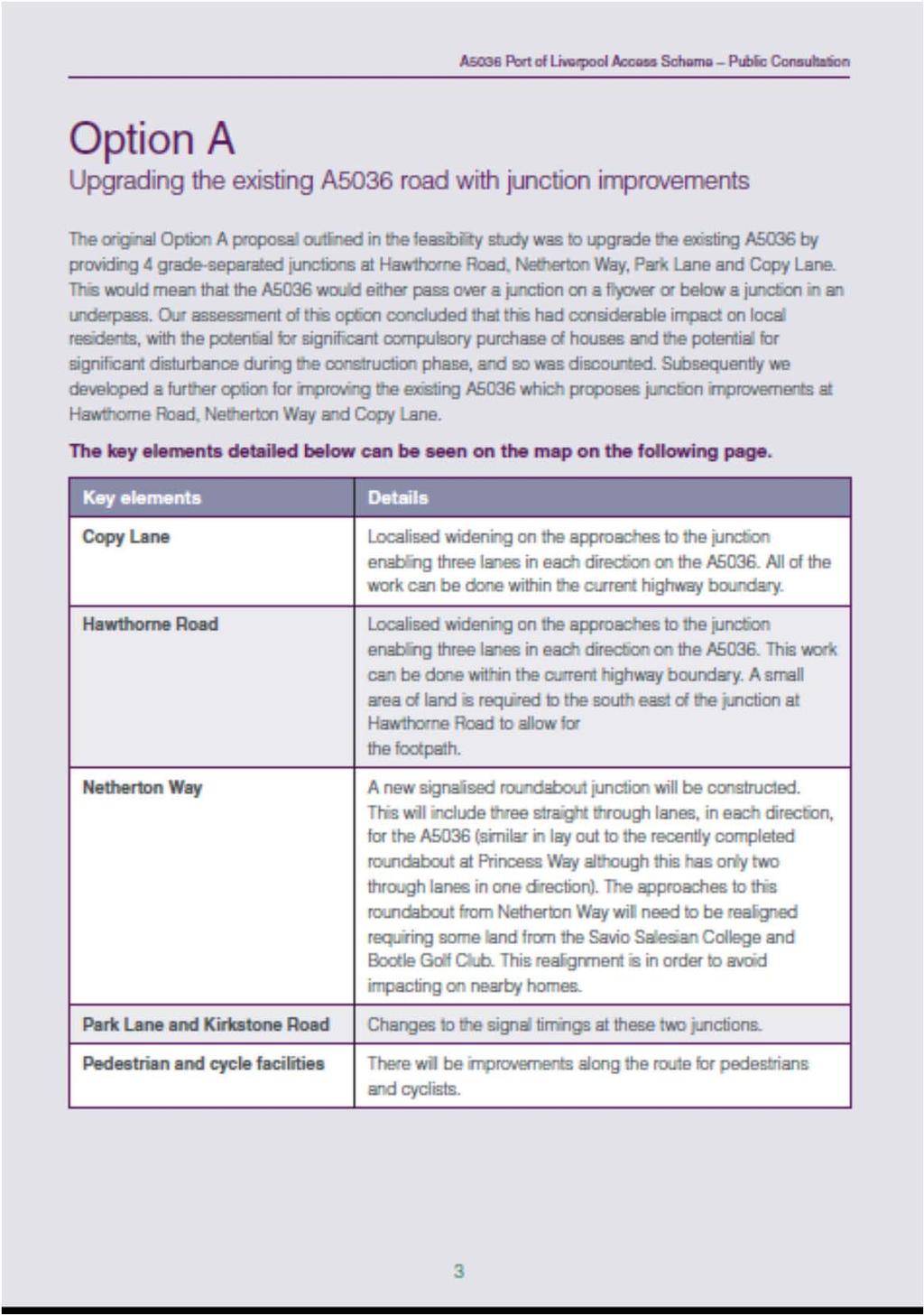
68 66
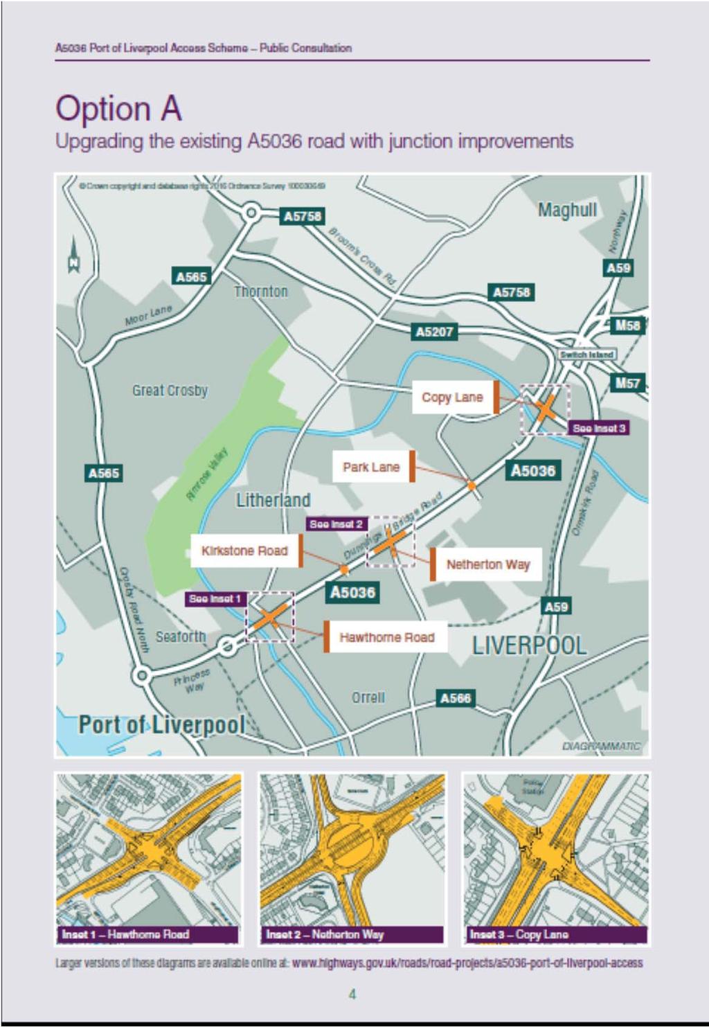
69 67
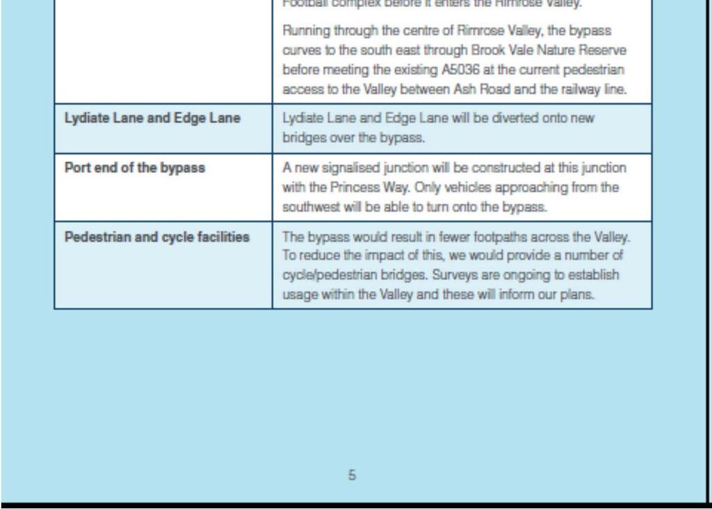
70 68
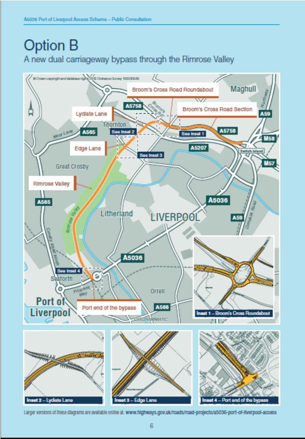
71 69

72 70
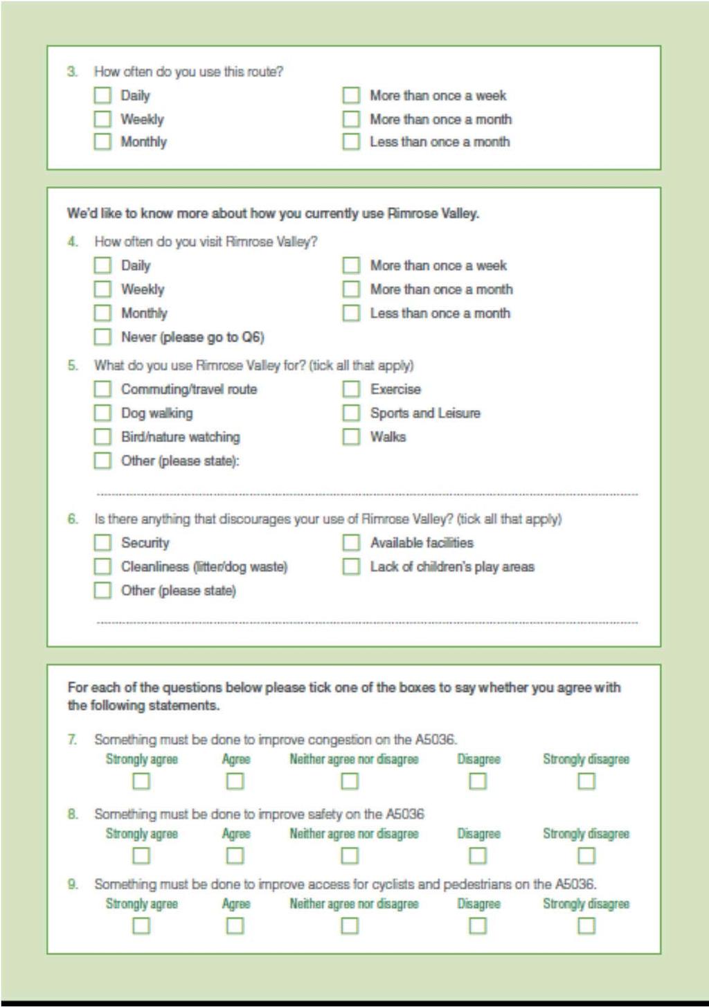
73 71
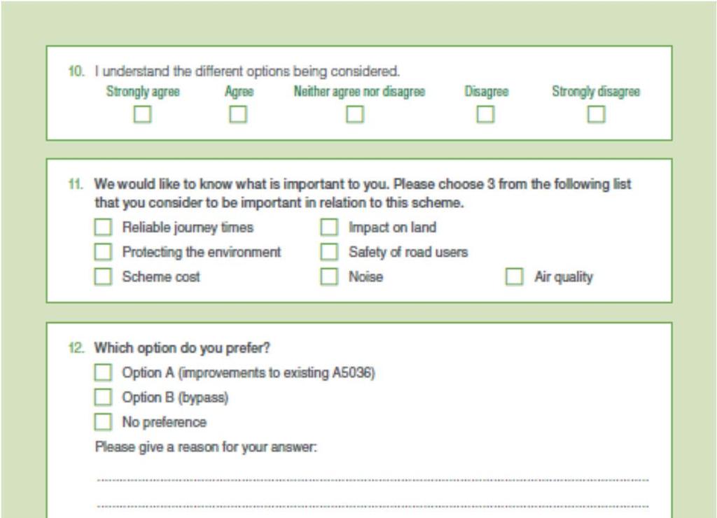
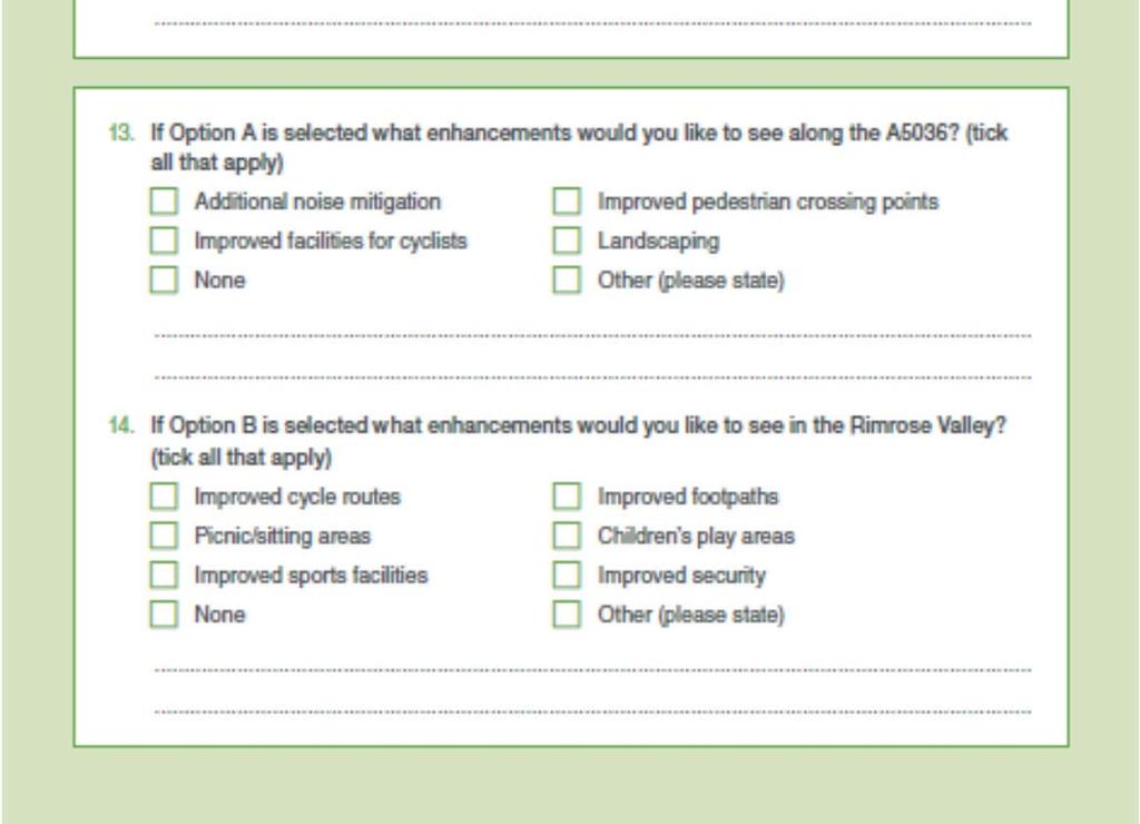
74 72
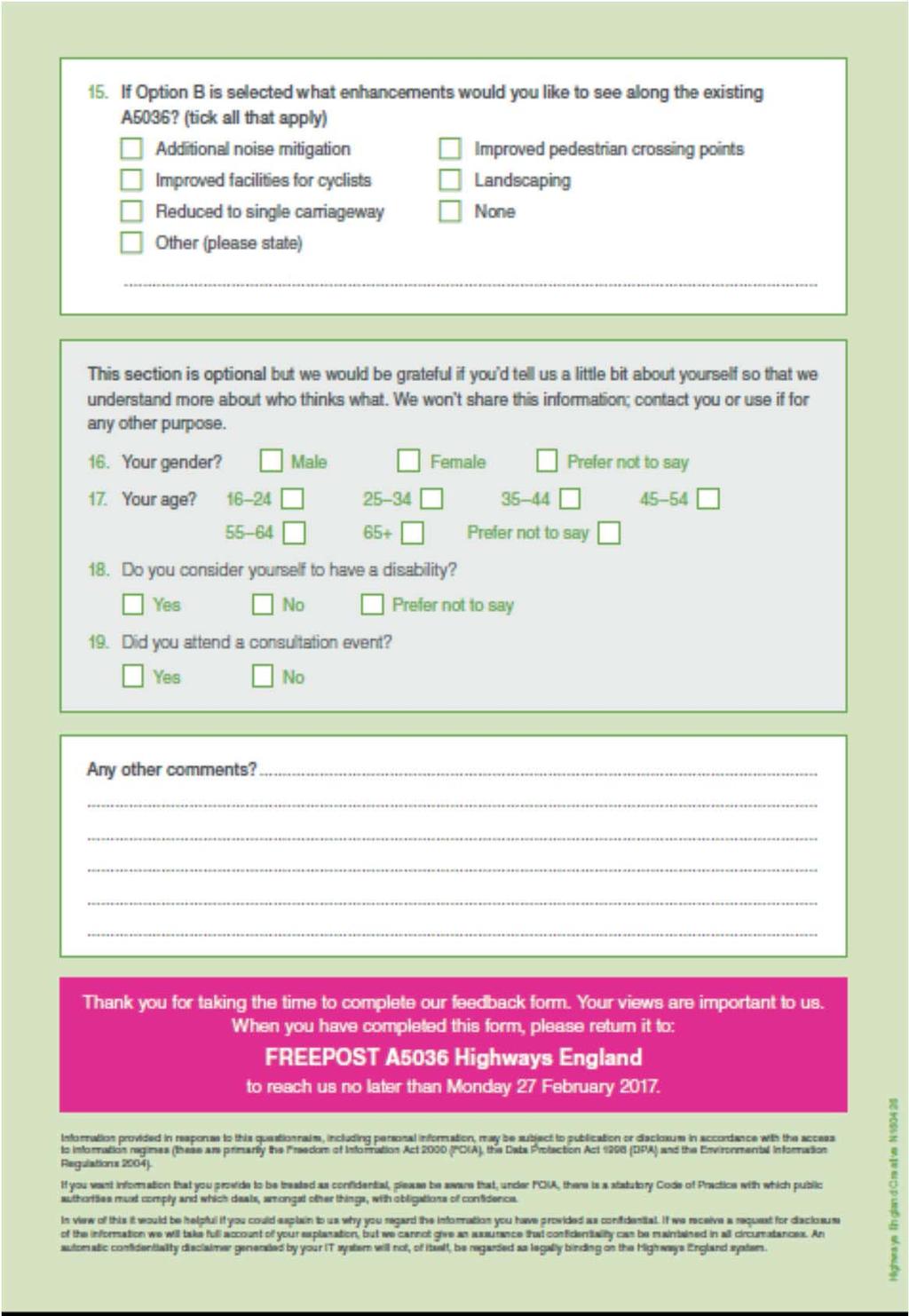
75 73
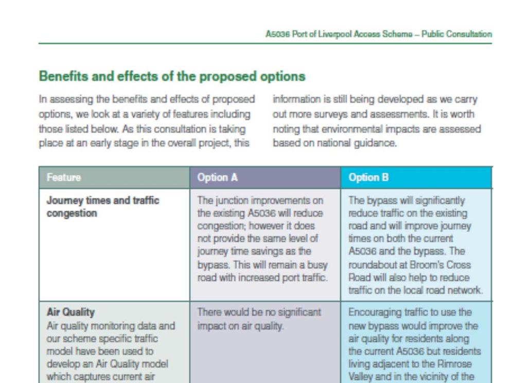
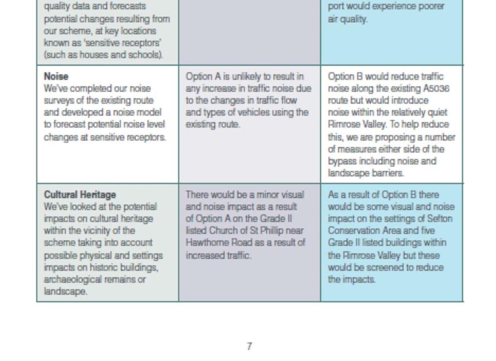
76 74
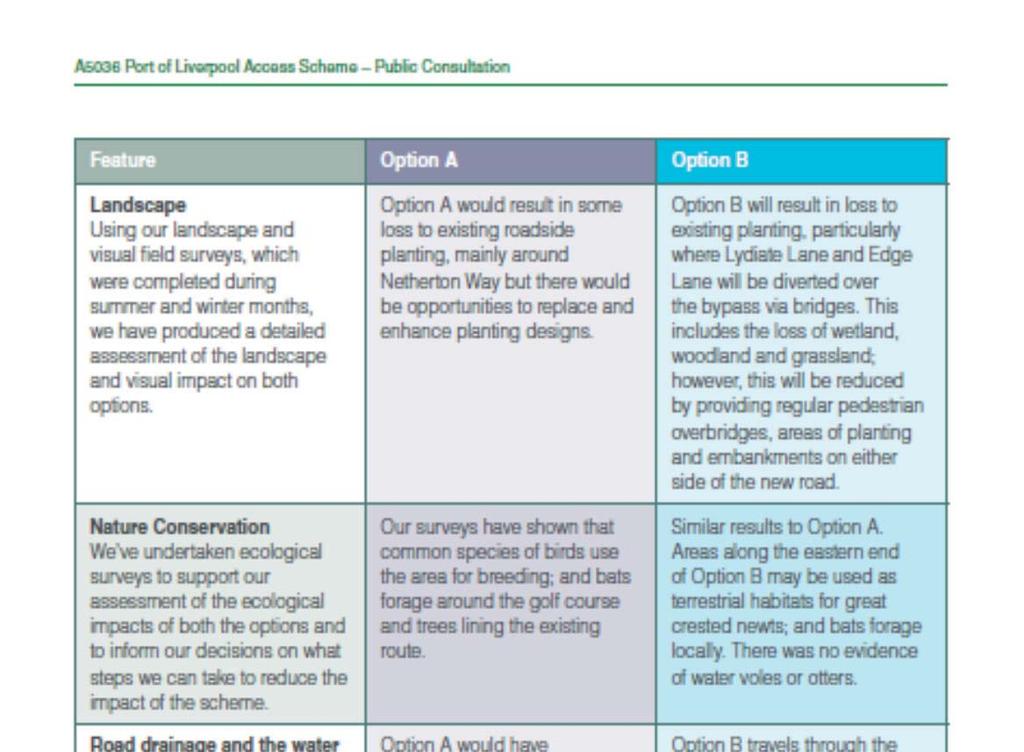
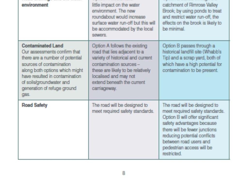
77 75
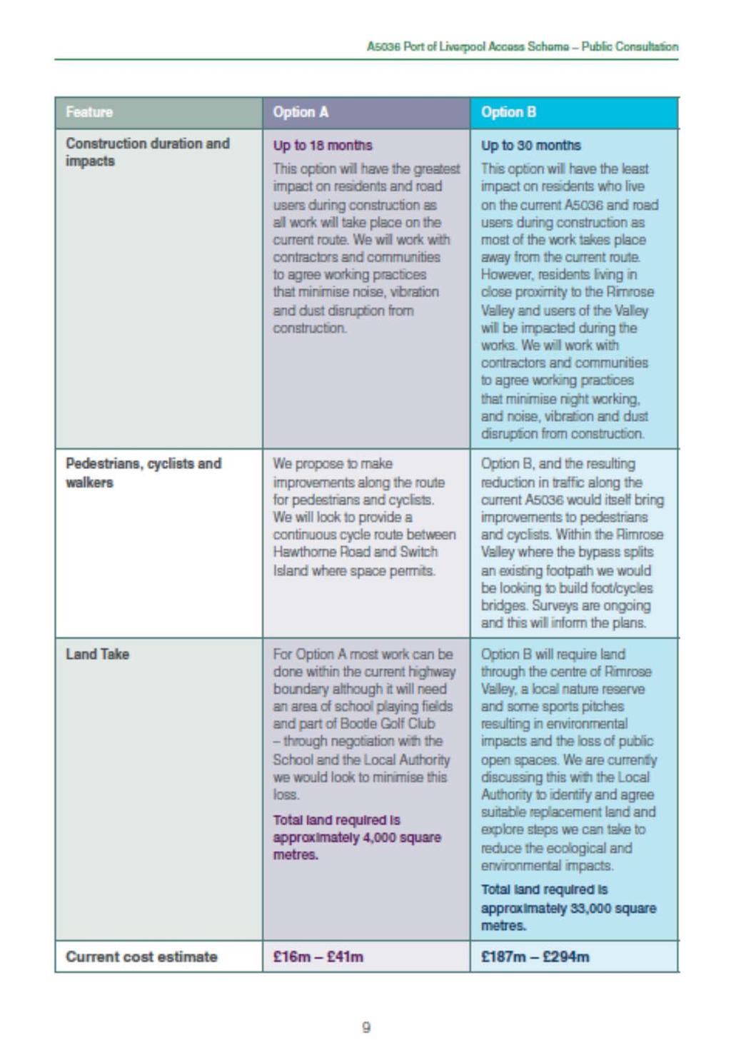
78 76
79 77
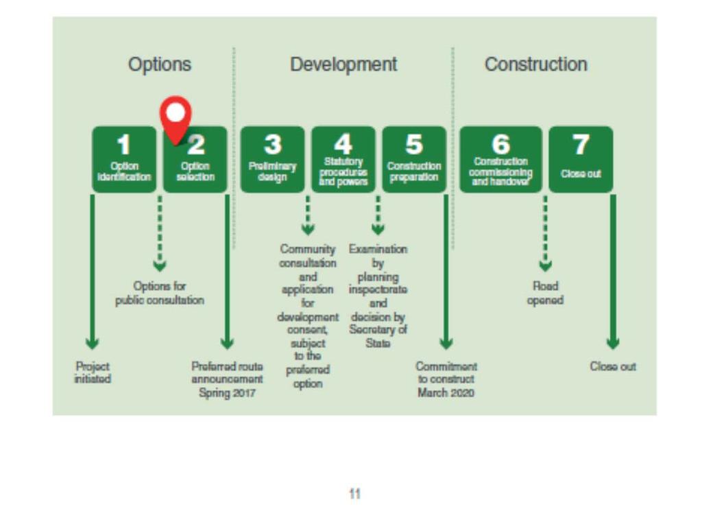
80 78
81 79
82 Appendix 3 Letter to Prescribed Consultees Consultee Name Address 1 Address 2 Address 3 Postcode 3 rd January 2017 Carl Stockton Project Manager Highways England Piccadilly Gate Store Street Manchester M1 2WD Dear Insert Name A5036 Port of Liverpool Access Public consultation Monday 16 January 2017 Monday 27 February 2017 The A5036 is a strategic route within the North West, and links The Port of Liverpool with the Switch Island interchange of the M57 and M58, which then in turn links to the M62 and M6 respectively. The port is the busiest sea-port in the North West and the sixth largest nationally in terms of total freight tonnage. It is also the home to Liverpool2, a new deep-water container terminal being built following a 300m investment by Peel Ports. The existing road already suffers from a high level of congestion and with significant development pressures, necessary for much needed regeneration, the situation can only get worse. Improvements to the A5036 were outlined in the government s Road Investment Strategy in December 2014 and are part of Highways England s Regional Investment Programme. The project aims to improve the A5036 either by bypassing the congested junctions along the route or by significant improvement of these junctions. The objectives of the project are: 1. To improve the traffic conditions on the main link between the Port of Liverpool and the Motorway Network to facilitate economic growth. 2. To improve safety for all road users and road workers. 3. To reduce requirements for future maintenance interventions. 4. To minimise the detrimental environmental effects and seek to protect and enhance the environment. 5. To improve local connectivity and the local network for all types of road user. 6. To provide value for money We are undertaking a consultation on the two current options for the scheme and are seeking your views on the proposals to help determine the preferred route. We have enclosed a copy of the consultation brochure which provides further information. You can comment by ing or writing to us using the contact details at the end of this 80
83 letter, or by filling in the questionnaire enclosed within the brochure. The questionnaire is also available on our webpage. We would also like to establish your preferred method of contact. It would be much appreciated if you could indicate to the team your preference of or letter for future contact, using the contact details below. As part of the consultation we have arranged a series of consultation events where you can discuss the proposals with the project team these have been detailed within the consultation brochure. All of our consultation information is available to view on our webpage at This includes an online version of the enclosed brochure, questionnaire and a scheme newsletter. All responses to the consultation will be considered and will inform, where appropriate, how the proposals are refined. We will consult again once the proposals are more developed and the enclosed brochure provides more information about this. Our contact addresses for sending comments are: A5036PortofLiverpool@highwaysengland.co.uk Post: FREEPOST A5036 Highways England, Piccadilly Gate, Store Street, Manchester, M1 2WD If you have any questions about the consultation the project team can be contacted on Please ensure your comments are returned by Monday 27 February 2017 at the latest to enable them to be considered. Yours Sincerely Carl Stockton Project Manager 81
84 Appendix 4 Letter to Category 1 Land Owners, Residents and Businesses Consultee Name Address 1 Address 2 Address 3 Postcode Carl Stockton Project Manager Highways England Piccadilly Gate Store Street Manchester M1 2WD 3 rd January 2017 Dear Insert Name A5036 Port of Liverpool Access Scheme Public Consultation Monday 16 th January 2017 Monday 27 th February 2017 Invitation to meet the project team In December 2014 Highways England was asked by the Government, as part of its Road Investment Strategy, to look at ways to improve road access to the Port of Liverpool. Since then we have been exploring a number of options to address this; our objectives being to: - Reduce congestion on the A Improve journey time reliability for drivers - Meet the needs of future traffic growth from existing and planned developments in the area. We have identified two possible solutions: Option A Upgrading the existing road; and Option B A new bypass through the Rimrose Valley connecting Princess Way to Broom s Cross Road. I am writing to you, as a landowner or tenant of land that could be affected by one of our options, to give you the opportunity to meet members of the project team on an individual basis. The attached plan shows the parcel of land potentially affected by the scheme. If you would like to meet to discuss the proposals and how they could affect you please call to make a suitable appointment on alternatively you can us on A5036PortofLiverpool@highwaysengland.co.uk. 82
85 Alternatively, if you would prefer, you could come to meet the project team at a drop-in session. These drop-in sessions will be held on: Tuesday 24 th January am to 11am and 5pm to 8pm The Park Hotel, Dunnings Bridge Road, Netherton, L30 6YN Wednesday 1 st February pm to 3pm Litherland Royal British Legion, Orrell Road, Litherland, L21 8NU Saturday 4 th February am to 11am SING Plus Centre, Cambridge Road, Seaforth, L21 1EX There are also a number of public information exhibitions where further information will be available and you will also have the opportunity to meet Highways England staff, learn more about the scheme and have your say. These exhibitions will be held on: Tuesday 24 th January am to 5pm The Park Hotel, Dunnings Bridge Road, Netherton, L30 6YN Friday 27 th January pm to 8pm St Faith s Church Hall, Milton Road, Waterloo, L22 4RF Monday 30 th January am to 5pm PlayFootball, Drummond Road, Crosby, L23 9YP Wednesday 1 st February pm to 8pm Litherland Royal British Legion, Orrell Road, Litherland, L21 8NU Saturday 4 th February am to 5pm SING Plus Centre, Cambridge Road, Seaforth, L21 1EX You will also find copies of the information brochure and questionnaire at the following locations from the 16 th January 2017: Maghull Library, Hall Lane, Maghull, L31 7BB Bootle Library, Stanley Road, Bootle, L20 3EN Netherton Library, Glovers Lane, Netherton, L30 3TL 83
86 Crosby Library, Crosby Road North, Crosby, L22 0LQ You can also find out more about the proposals by visiting the scheme s website If you are unable to attend these events, we would welcome your views either via the online response form which can be found on the website or by ing A5036PortofLiverpool@highwaysengland.co.uk. If you have any questions about this consultation please call the project team on Yours faithfully Carl Stockton Project Manager 84
87 Appendix 5 Letter to Category 2 Residents and Businesses Consultee Name Address 1 Address 2 Address 3 Postcode Carl Stockton Project Manager Highways England Piccadilly Gate Store Street Manchester M1 2WD 3 rd January 2017 Dear Insert Name A5036 Port of Liverpool Access Scheme Public Consultation Monday 16 th January 2017 Monday 27 th February 2017 Invitation to a Local Residents Drop-In Session In December 2014 Highways England was asked by the Government, as part of its Road Investment Strategy, to look at ways to improve road access to the Port of Liverpool. Since then we have been exploring a number of options to address this; our objectives being to: - Reduce congestion on the A Improve journey time reliability for drivers - Meet the needs of future traffic growth from existing and planned developments in the area. We have identified two possible solutions: Option A Upgrading the existing A5036 road; and Option B A new bypass through the Rimrose Valley connecting Princess Way to Broom s Cross Road. Before we select the preferred option I am writing to you, as a resident living closest to our proposals, to give you the opportunity to meet members of the project team on an individual basis at a drop-in session to discuss these options and how it may affect you. These drop-in sessions will be held on: Tuesday 24 th January am to 11am 85
88 Or 5pm to 8pm The Park Hotel, Dunnings Bridge Road, Netherton, L30 6YN Wednesday 1 st February pm to 3pm Litherland Royal British Legion, Orrell Road, Litherland, L21 8NU Saturday 4 th February am to 11am SING Plus Centre, Cambridge Road, Seaforth, L21 1EX If these dates are inconvenient please contact the Project Team on to make alternative arrangements. There are also a number of public information exhibitions where further information will be available and you will also have the opportunity to meet the Highways England team to learn more about the scheme and have your say. These exhibitions will be held on: Tuesday 24 th January am to 5pm The Park Hotel, Dunnings Bridge Road, Netherton, L30 6YN Friday 27 th January pm to 8pm St Faith s Church Hall, Milton Road, Waterloo, L22 4RF Monday 30 th January am to 5pm PlayFootball, Drummond Road, Crosby, L23 9YP Wednesday 1 st February pm to 8pm Litherland Royal British Legion, Orrell Road, Litherland, L21 8NU Saturday 4 th February am to 5pm SING Plus Centre, Cambridge Road, Seaforth, L21 1EX You will also find copies of the information brochure and questionnaire at the following locations from the 16 th January 2017: Maghull Library, Hall Lane, Maghull, L31 7BB Bootle Library, Stanley Road, Bootle, L20 3EN Netherton Library, Glovers Lane, Netherton, L30 3TL Crosby Library, Crosby Road North, Crosby, L22 0LQ 86
89 You can also find out more about the proposals by visiting the scheme s website If you are unable to attend these events, we would welcome your views either via the online response form which can be found on the website or by ing A5036PortofLiverpool@highwaysengland.co.uk. If you have any questions about this consultation please call the project team on Yours faithfully Carl Stockton Project Manager 87
90 Appendix 6 The Champion Distribution by Postcode Group 2 Crosby & Litherland L21-0 Ford L21 1 Seaforth L21 2 Litherland L21 3 Seaforth L21 4 Seaforth L21 5 Litherland L21 6 Litherland L21 7 Stanley Park L21 8 Seaforth L21 9 Hatton Park L22 0 Waterloo L22 1 Waterloo L22 2 Waterloo L22 3 Waterloo L22 4 Waterloo L22 5 Waterloo L22 6 Waterloo L22 7 Waterloo L22 8 Waterloo L22 9 Waterloo L23 0 Crosby L23 1 Thornton L23 2 Thornton L23 3 Crosby L23 4 Thornton L23 5 Crosby L23 6 Brighton-le-Sands L23 7 Crosby L23 8 Blundell Sands L23 9 Crosby Office and Multi Drops Anfield & Walton L4 & L9 Free Pick-up Copies Aintree & Maghull L10 2 Aintree L10 3 Aintree L10 6 Aintree L10 8 Aintree L30 8 Old Roan L31 0 Maghull
91 L31 1 Melling L31 2 Lydiate L31 3 Maghull L31 4 Lydiate L31 5 Maghull L31 6 Kennesse Green L31 7 Maghull L31 8 Maghull L31 9 Maghull Office & Multi Drops Bootle L20 0 Bootle L20 2 Bootle L20 3 Bootle L20 4 Bootle L20 5 Bootle L20 6 Bootle L20 7 Bootle L20 9 Bootle L30 0 Netherton L30 1 Netherton L30 2 Netherton L30 3 Netherton L30 5 Netherton L30 6 Netherton L30 7 Netherton L30 9 Netherton Office & Multi Drops Sefton Village Distribution to all properties within Sefton Village 89


92 Appendix 7 Consultation Event Boards 90
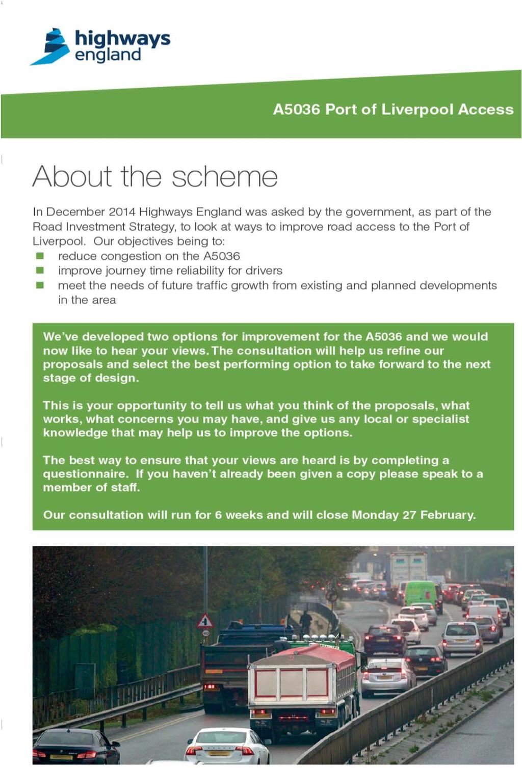
93 91
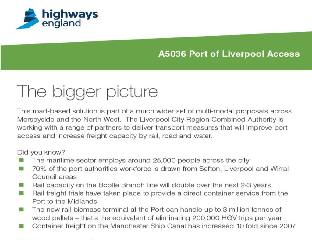

94 92
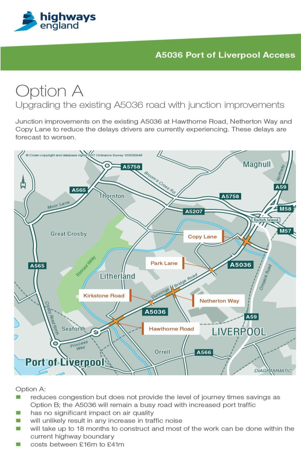
95 93
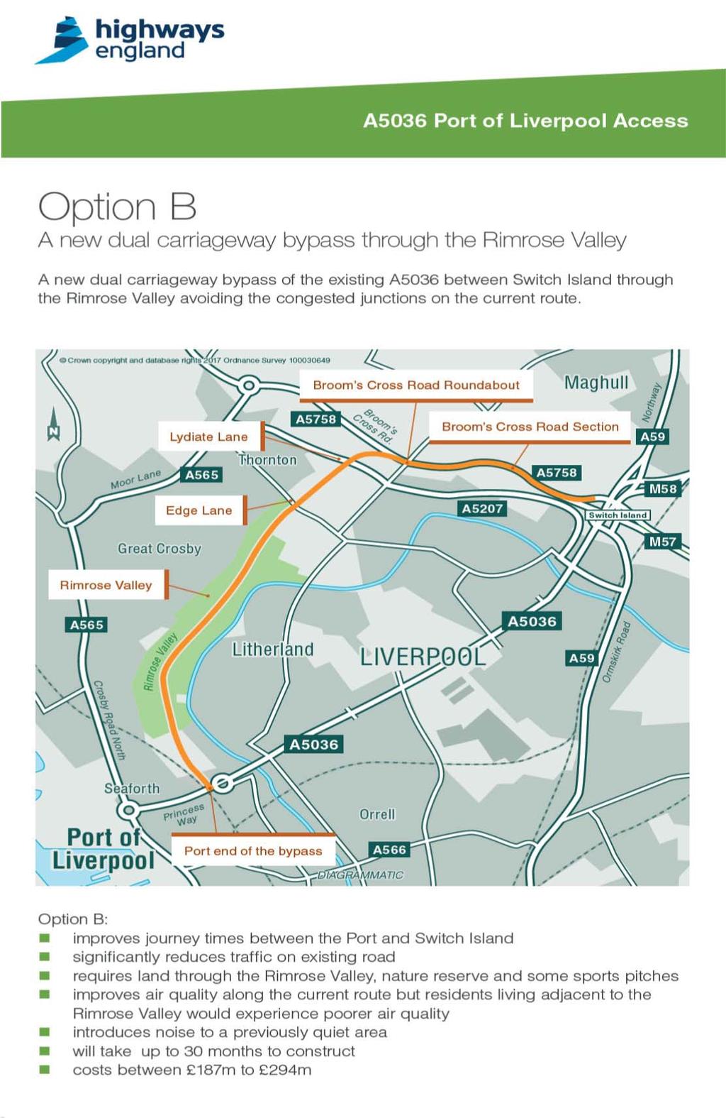
96 94
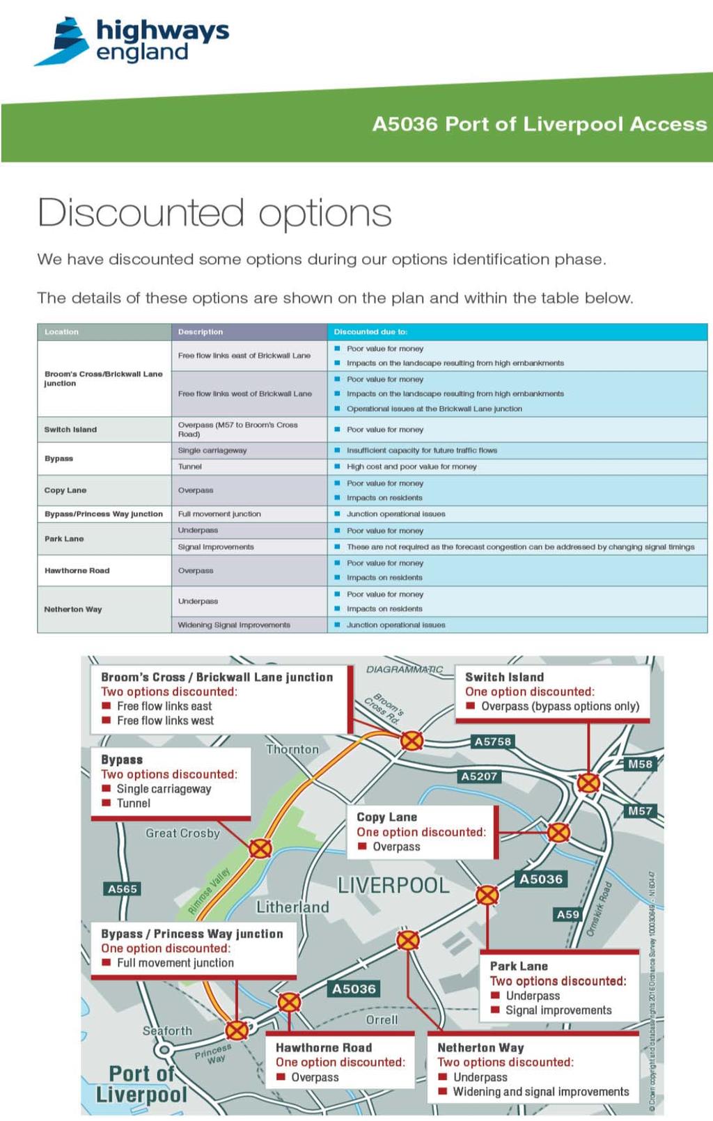
97 95
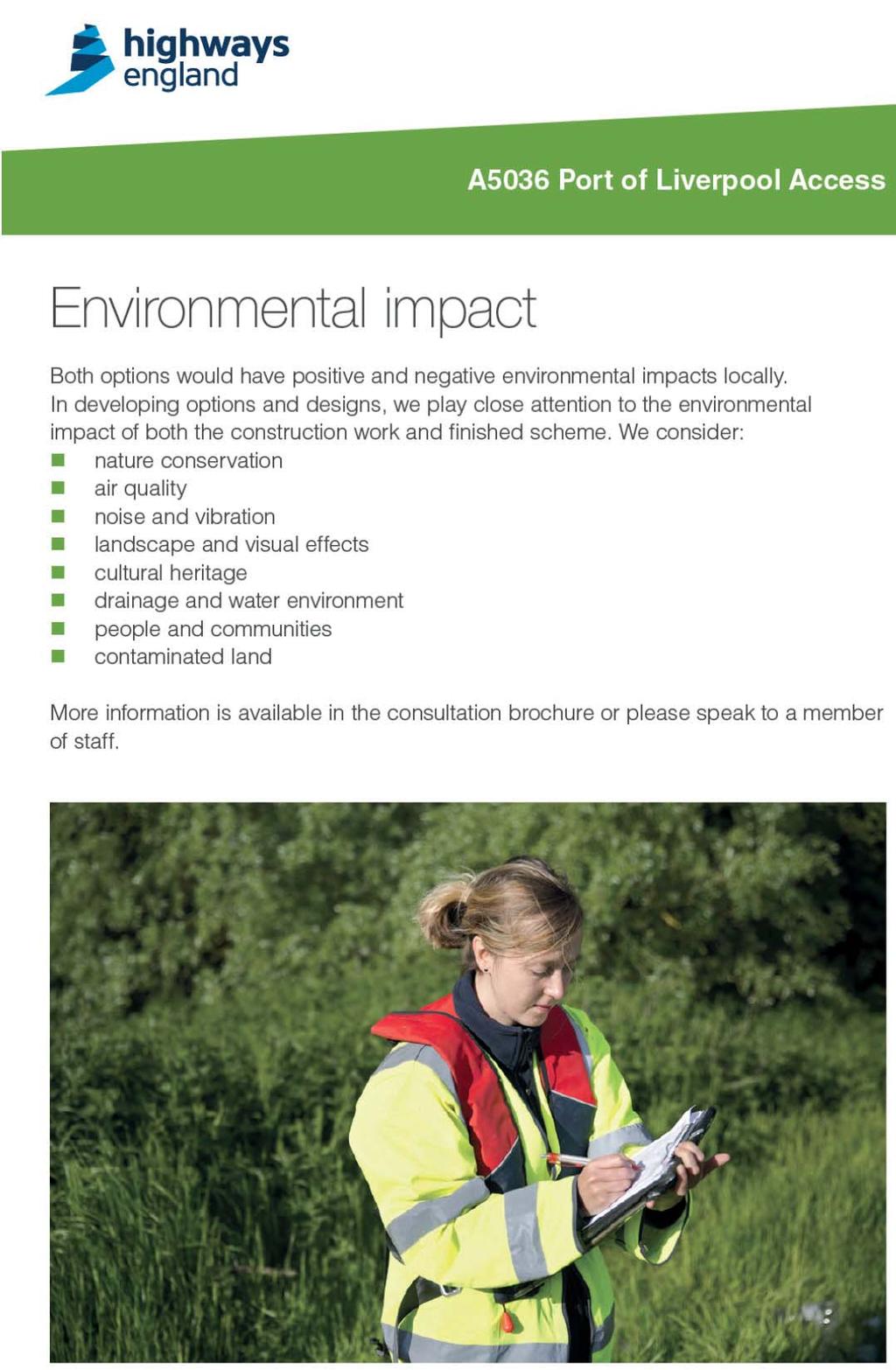
98 96

99 Appendix 8 - Postcodes of all questionnaire responses 97
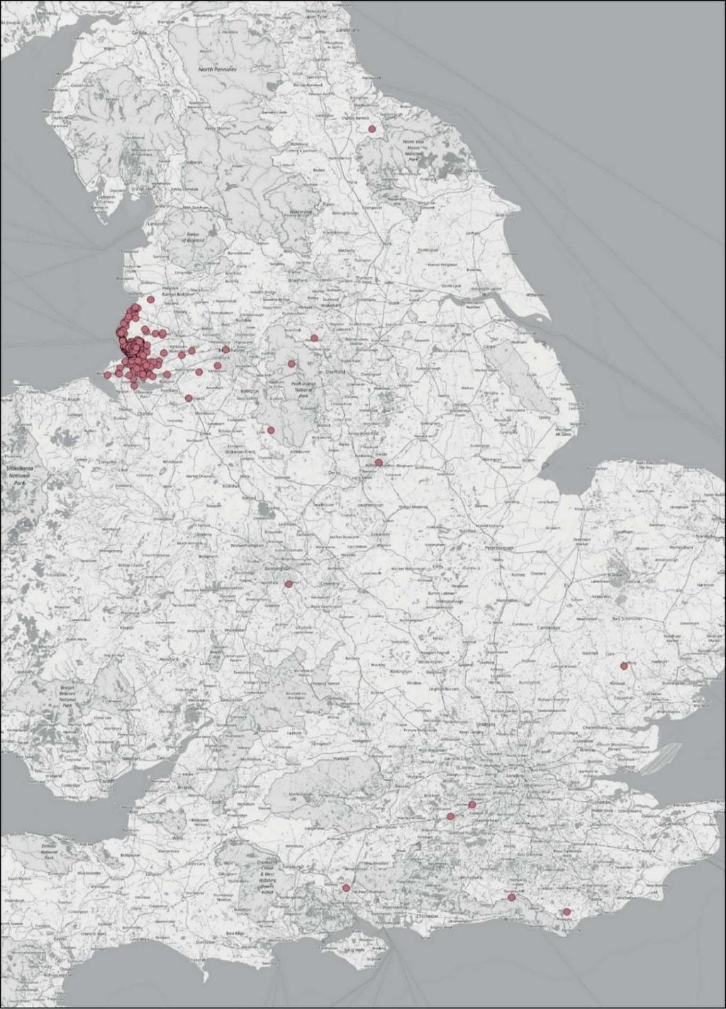
100 98
A303. Sparkford to Ilchester Dualling Scheme Preferred Route Announcement
 A303 Sparkford to Ilchester Dualling Scheme Preferred Route Announcement About this booklet This booklet presents the preferred route for the A303 Sparkford to Ilchester dualling scheme and a summary of
A30 Chiverton to Carland Cross Statement of Community Consultation
 A30 Chiverton to Carland Cross Statement of Community Consultation Table of contents 1 Introduction... 3 2 The application... 4 3 The scheme... 5 4 Early stages of consultation... 7 5 Statutory consultation...
Proposals for the Harrogate Road / New Line Junction Improvement Scheme. August / September Supported by:
 Proposals for the Harrogate / New Line Junction Improvement Scheme August / September 2016 Supported by: Introduction Key Benefits Proposals are currently being developed for changes to the junction of
M621. Junctions 1 to 7 Improvement scheme. Share your views
 M621 Junctions 1 to 7 Improvement scheme Share your views Investing in your roads Every road user wants less congested roads to enable swift, safe, comfortable and informed travel. On behalf of the government,
Statement of Community Consultation. Trans Pennine Upgrade: Statement of Community Consultation (SoCC)
") Trans Pennine Upgrade: Statement of Community Consultation (SoCC) February 2018 Section 47(1) of the Planning Act 2008 states that the promoter of a proposed Development Consent Order (DCO) application
Trans Pennine Upgrade: Statement of Community Consultation (SoCC) February 2018 Section 47(1) of the Planning Act 2008 states that the promoter of a proposed Development Consent Order (DCO) application
A Master Plan is one of the most important documents that can be prepared by an Airport.
 The Master Plan A Master Plan is one of the most important documents that can be prepared by an Airport. A Master Plan is a visionary and a strategic document detailing planning initiatives for the Airport
CONSULTATION PROCESS AND FEEDBACK - EXECUTIVE SUMMARY
 CONSULTATION PROCESS AND FEEDBACK - EXECUTIVE SUMMARY This executive summary presents a brief overview of the public and stakeholder consultation on proposals to optimise the Doncaster bus network, undertaken
M621 Junctions 1 to 7 Improvement Scheme Public Consultation Report
 M621 Junctions 1 to 7 Improvement Scheme March 2018 Ref: 551464 Table of Contents Executive summary... 4 1 INTRODUCTION... 7 1.1 1.2 1.3 1.4 PURPOSE OF THE REPORT... 7 BACKGROUND TO THE SCHEME... 7 OPTION
opyright East Riding of Yorkshire Cou
 STATEMENT OF COMMUNITY INVOLVEMENT NOVEMBER 2009 EASTERN PARK & RIDE HULL ENGLAND & LYLE LTD MORTON HOUSE MORTON ROAD DARLINGTON DL1 4PT T: 01325 469236 F:01325 489395 opyright East Riding of Yorkshire
Southsea Flooding and Coastal Erosion Risk Management Scheme
 Southsea Flooding and Coastal Erosion Risk Management Scheme Public Consultation Report 3 rd November 29th December 2014 TABLE OF CONTENTS 1 INTRODUCTION... ERROR! BOOKMARK NOT DEFINED. 1.1 Purpose of
Today we are showing you the early designs to improve the A27 at Arundel and we would like to hear your views on our options.
 Welcome Welcome to the Highways England A27 Arundel Bypass public consultation. Thank you for coming. Today we are showing you the early designs to improve the A27 at Arundel and we would like to hear
A303. Sparkford to Ilchester Dualling Scheme. Public consultation. Welcome. Highways England -- creative MCR18_0016
 Sparkford to Ilchester Dualling Scheme Public consultation Welcome Background The /A358 corridor provides vital east-west connectivity between the south west and London and the south east for people, communities
A30 Chiverton to Carland Cross Improvement Scheme Preferred route announcement
 A30 Chiverton to Carland Cross Improvement Scheme Preferred route announcement Introduction The Government s Road Investment Strategy, published in 2014, sets out the vision for the strategic road network
Local Development Scheme
 Local Development Scheme August 2014 Local Development Scheme (August 2014) / Page 2 Contents Section 1: Introduction Great Yarmouth s Development Plan 4 Section 2: Plan Making Process Public participation
M56. New Junction 11a Summary of the consultation report
 M56 New Junction 11a Summary of the consultation report August 2017 M56 New Junction 11a Summary of the public consultation The scheme The M56 New Junction 11a scheme is part of our continued programme
Gold Coast. Rapid Transit. Chapter twelve Social impact. Chapter content
 Gold Coast Rapid Transit Chapter twelve Social impact Chapter content Social impact assessment process...235 Existing community profile...237 Consultation...238 Social impacts and mitigation strategies...239
Road Investment Strategy A1 East of England Strategic Road Study
 Road Investment Strategy 2020-2025 A1 East of England Strategic Road Study Report of the fourth meeting of the Stakeholder Reference Group March 2017 The fourth meeting of the A1 Stakeholder Reference
Heathrow Consultation January March 2018
 A briefing from HACAN Heathrow Consultation January March 2018 Heathrow launched its biggest ever consultation on 17 th January. It closes on 28 th March. In reality, it is two consultations running in
Major Scheme Business Case Summary Report for Programme Entry
 Paper A Heart of South West Local Transport Board Major Scheme Business Case Summary Report for Programme Entry M5 Junction 25, Taunton July 2016 1 SCHEME SUMMARY Scheme Name M5 Junction 25, Taunton Date
SOUTH CAMBRIDGESHIRE DISTRICT COUNCIL. Executive Director / Senior Planning Policy Officer
 SOUTH CAMBRIDGESHIRE DISTRICT COUNCIL REPORT TO: Leader and Cabinet 8 May 2008 AUTHOR/S: Executive Director / Senior Planning Policy Officer SOUTH CAMBRIDGESHIRE DISTRICT COUNCIL S RESPONSE TO UTTLESFORD
Regional Investment Programme
 Regional Investment Programme A27 Worthing and Lancing improvements Report on Public Consultation April 2018 Registered office Bridge House, 1 Walnut Tree Close, Guildford, GU1 4LZ Highways England Company
A63 Castle Street, Hull HullBID Network Lunch 24 August 2017
 A63 Castle Street, Hull HullBID Network Lunch 24 August 2017 James D Leeming Senior Project Manager What we will cover today? Introduction to Highways England and the Road Investment Strategy A63 Scheme
Brisbane Metro Infrastructure Association of Queensland 14 February 2018
 Brisbane Metro Infrastructure Association of Queensland 14 February 2018 Agenda Brisbane Metro project update Packaging and procurement overview Panel discussion Audience Q&A The journey so far Planning
Proposal for gypsy and traveller accommodation on land at Lower Hollow Copse (Pot Common), Copthorne. Statement of Community Involvement
, Copthorne. Statement of Community Involvement") Proposal for gypsy and traveller accommodation on land at Lower Hollow Copse (Pot Common), Copthorne Statement of Community Involvement Prepared by WYG Environment Planning Transport Ltd on behalf of the
Proposal for gypsy and traveller accommodation on land at Lower Hollow Copse (Pot Common), Copthorne Statement of Community Involvement Prepared by WYG Environment Planning Transport Ltd on behalf of the
Economic Development Sub- Committee
 Report title: Economic Development Sub- Committee Item No. Date of meeting: 24 November 2016 A47 Road Investment Strategy - update Responsible Chief Tom McCabe Executive Director, Community Officer: and
A21 TONBRIDGE TO PEMBURY DUALLING. Statement of Case
 A21 TONBRIDGE TO PEMBURY DUALLING Statement of Case In Respect of Applications for the Demolition of Listed Buildings Under the Provisions of the Planning (Listed Buildings and Conservation Areas) Act
EXPLANATORY STATEMENT
 THE LONDON TO FISHGUARD TRUNK ROAD (A40) (PENBLEWIN TO SLEBECH PARK IMPROVEMENT) ORDER 200- AND THE LONDON TO FISHGUARD TRUNK ROAD (A40) (PENBLEWIN TO SLEBECH PARK IMPROVEMENT SIDE ROADS) ORDER 200-1.
Response to the London Heathrow Airport Expansion Public Consultation
 Response to the London Heathrow Airport Expansion Public Consultation Summary This report sets out the response to the Heathrow Airport s consultation on airport expansion and airspace change. The consultation
FUTURE AIRSPACE CHANGE
 HEATHROW EXPANSION FUTURE AIRSPACE CHANGE UPDATE SEPTEMBER 2018 On 25 June 2018, Parliament formally backed Heathrow expansion, with MPs voting in support of the Government s Airports National Policy Statement
an engineering, safety, environmental, traffic and economic assessment of each option to inform a preferred route option choice; 3) Development and as
 Development and as") Page: 42 Infrastructure Services REPORT TO ABERDEENSHIRE COUNCIL COMMITTEE 26 APRIL 2018 A96 ABERDEEN TO INVERNESS DUALLING POSITION STATEMENT 1 Recommendations Aberdeenshire Council is recommended to:
Page: 42 Infrastructure Services REPORT TO ABERDEENSHIRE COUNCIL COMMITTEE 26 APRIL 2018 A96 ABERDEEN TO INVERNESS DUALLING POSITION STATEMENT 1 Recommendations Aberdeenshire Council is recommended to:
Report to: Greater Cambridge Partnership Joint Assembly 18 January A10 Foxton level crossing bypass and travel hub
 Report to: Greater Cambridge Partnership Joint Assembly 18 January 2018 Lead officer: Chris Tunstall GCP Director of Transport A10 Foxton level crossing bypass and travel hub 1. Purpose 1.1 The list of
1.1. The purpose of this report is to seek approval for the adoption and publication of the Sports Pitches Strategy for East Dunbartonshire.
 REPORT FOR EDLC BOARD Report Title: EDC Pitches Strategy Update Contact Officer: Mark Grant (0141 777 3146) Date: 30 th March 2016 Agenda Item No: 5 Report No: EDLCT/52/15/MG 1.0 PURPOSE 1.1. The purpose
Open Report on behalf of Richard Wills, Executive Director for Environment and Economy
 Agenda Item 7 Executive Open Report on behalf of Richard Wills, Executive Director for Environment and Economy Report to: Executive Date: 02 September 2014 Subject: Lincoln East West Link Road Phase 1
Blackburn Road Blackburn Level Crossing Removal. Frequently Asked Questions August 2014 GENERAL
 Frequently Asked Questions August 2014 Blackburn Road Blackburn Level Crossing Removal GENERAL What is the project? The Victorian Government has committed to eliminating a number of the busiest level crossings
M20 junction 10a improvement scheme. We want to hear your views
 M20 junction 10a improvement scheme We want to hear your views March 2016 2 About us Highways England, formerly the Highways Agency, is a government run company. We are responsible for operation, maintenance
Commissioning Director - Environment
 Finchley and Golders Green Area Committee 27 April 2017 Title Report of Wards Status Urgent Key Enclosures Summers Lane,N12 Request for Pedestrian Improvements Commissioning Director - Environment Woodhouse
A358 Taunton to Southfields Dualling Scheme. Corfe Parish THE FACTS
 A358 Taunton to Southfields Dualling Scheme Corfe Parish THE FACTS A358 (Southfields to M5) Highways England only proposed 1 route for public consultation Other A303 schemes recently been in public consultation
A5-M1 Link (Dunstable Northern Bypass) Explanatory Statement
 Explanatory Statement") A5-M1 Link (Dunstable Northern Bypass) Explanatory Statement Broadway Broad Street Birmingham B15 1BL HIGHWAYS AGENCY A5-M1 LINK (DUNSTABLE NORTHERN BYPASS) EXPLANATORY STATEMENT Introduction The Highways
A5-M1 Link (Dunstable Northern Bypass) Explanatory Statement Broadway Broad Street Birmingham B15 1BL HIGHWAYS AGENCY A5-M1 LINK (DUNSTABLE NORTHERN BYPASS) EXPLANATORY STATEMENT Introduction The Highways
1. Summary of key points 2
 Petitions Committee NEVAR petition: Cardiff Airport access road This brief sets out the history and policy background to the development of proposals for improved surface access to Cardiff Airport (CA).
TRANSPORT FOR GREATER MANCHESTER COMMITTEE REPORT FOR RESOLUTION
 TRANSPORT FOR GREATER MANCHESTER COMMITTEE REPORT FOR RESOLUTION DATE: 11 November 2011 SUBJECT: REPORT OF: Proposed making of a Quality Partnership Scheme for the A6 corridor between Manchester and Hazel
Smart Motorways Programme
 Smart Motorways Programme M27 Junction 4 to 11 Smart Motorway Response to Statutory Instrument Consultation The introduction of variable mandatory speed limits July 2018 Contents Executive Summary 3 1.
M54 to M6/M6 Toll Link Road Public consultation
 to M6/M6 Toll Link Road Public consultation 15 September 2017 to 13 October 2017 Contents Introduction 4 5 Why do we need this scheme? 6 Previous consultation 7 8 Modified options 9 Option B West 10 Option
INFORMATION FOR STANWELL MOOR AND STANWELL COMMUNITIES
 Proposed north west runway Stanwell Moor Stanwell All maps contain OS data Crown copyright and database right 2018 INFORMATION FOR STANWELL MOOR AND STANWELL COMMUNITIES JANUARY 2018 Airport Expansion
Wolverhampton City Council
 Agenda Item: 7G Wolverhampton City Council OPEN EXECUTIVE DECISION ITEM Cabinet / Cabinet Team CABINET Date 24 MARCH 2010 Portfolio(s) Originating Service Group(s) COUNCILLOR MRS BRADLEY (REGENERATION
As part of our transport vision, Leeds City Council, working with the West Yorkshire Combined Authority and Leeds Bradford Airport Company, is
 As part of our transport vision, Leeds City Council, working with the West Yorkshire Combined Authority and Leeds Bradford Airport Company, is considering options for improving surface access and connectivity
Terms of Reference: Introduction
 Terms of Reference: Assessment of airport-airline engagement on the appropriate scope, design and cost of new runway capacity; and Support in analysing technical responses to the Government s draft NPS
Planning Act The Network Rail (Western Rail Link to Heathrow) Order. Statement of Community Consultation
 Order. Statement of Community Consultation") The Network Rail (Western Rail Link to Heathrow) Order Planning Act 2008 The Network Rail (Western Rail Link to Heathrow) Order Document Reference Author Final Network Rail Date 19 March 2018 Revision
The Network Rail (Western Rail Link to Heathrow) Order Planning Act 2008 The Network Rail (Western Rail Link to Heathrow) Order Document Reference Author Final Network Rail Date 19 March 2018 Revision
PSP 75 Lancefield Road. Northern Jacksons Creek Crossing Supplementary Information
 PSP 75 Lancefield Road Northern Jacksons Creek Crossing Supplementary Information September 2017 The northern crossing of Jacksons Creek proposed within the Lancefield Road PSP is a key part of the ultimate
OUTLINE RESPONSE FROM WELWYN PLANNING & AMENITYGROUP (WPAG) TO CONSULTATION OVER PROPOSED EXPANSION OF LUTON AIRPORT
 TO CONSULTATION OVER PROPOSED EXPANSION OF LUTON AIRPORT") OUTLINE RESPONSE FROM WELWYN PLANNING & AMENITYGROUP (WPAG) TO CONSULTATION OVER PROPOSED EPANSION OF LUTON AIRPORT This draft follows the format of the supplied response booklet. The contents have been
OUTLINE RESPONSE FROM WELWYN PLANNING & AMENITYGROUP (WPAG) TO CONSULTATION OVER PROPOSED EPANSION OF LUTON AIRPORT This draft follows the format of the supplied response booklet. The contents have been
M2 Junction 5. improvements scheme. Preferred route announcement
 M2 Junction 5 improvements scheme Preferred route announcement May 2018 Investing in your roads Why is the scheme needed? At Highways England we believe in a connected country and our network makes these
Liverpool John Lennon Airport Master Plan to Interim Consultation Summary October 2017
 to 2050 October 2017 Contents Executive Summary 1. Introduction 2. Consultation Methods 3. Summary of Feedback 4. Next Steps Appendix 1. Consultation Material (Website, Leaflet, Questionnaire, Exhibition
Member-led Review of Cycling Infrastructure
 Member-led Review of Cycling Infrastructure Survey Results: A1 Cambridge to Royston June 17 cambridgeshire.gov.uk Contents 1. Introduction... 3. About you... 3.1 Age... 3. What is your gender?... 3.3 Do
Lower Thames Crossing Consultation
 March 2017 Lower Thames Crossing Consultation Summary report Addendum FINAL VERSION Ipsos MORI Lower Thames Crossing Consultation Addendum Report 2017 Ipsos MORI all rights reserved. The contents of this
Agenda Item 5: Rail East Midlands Rail Franchise Consultation
 Strategic Transport Forum 15 th September 2017 Agenda Item 5: Rail East Midlands Rail Franchise Consultation Recommendation: It is recommended that the Forum agree (subject to any amendments agreed by
Regulatory Committee
 Page 1 - Proposed Turning Movement Bans at South Gate Junction, Dorchester Regulatory Committee Date of Meeting 16 March 2017 Officer Subject of Report Executive Summary Andrew Martin Service Director
A63 Preferred Route Announcement
 Safe roads, Reliable journeys, Informed travellers Castle Street Improvements A63 Preferred Route Announcement Preferred Route Announcement i An Executive Agency of the Introduction During Spring 2009,
In your area. Stonebroom to Clay Cross LA09. June Introduction
 June 2018 www.hs2.org.uk In your area to Clay Cross LA09 Midland Main Line Shirland Tupton Clay Cross A61 Stretton Midland Main Line to Chesterfield and Sheffield Pilsley A6175 HS2 Phase 2b spur Morton
M25 J25 Improvement Scheme Report on Public Consultation June 2017
 M25 J25 Improvement Scheme Report on Public Consultation June 2017 This consultation report reflects the views of the consultation on the M25 J25 improvement scheme which took place between 16 January
M56. New Junction 11a Preferred route announcement
 New Junction 11a Preferred route announcement August 2017 New Junction 11a Preferred route announcement Introduction The New Junction 11A scheme introduces a new motorway junction to the motorway between
East Lancashire Highways and Transport Masterplan East Lancashire Rail Connectivity Study Conditional Output Statement (Appendix 'A' refers)
") Report to the Cabinet Member for Highways and Transport Report submitted by: Director of Corporate Commissioning Date: 1 June 2015 Part I Electoral Divisions affected: All East Lancashire Highways and
Report to the Cabinet Member for Highways and Transport Report submitted by: Director of Corporate Commissioning Date: 1 June 2015 Part I Electoral Divisions affected: All East Lancashire Highways and
Report of the Strategic Director of Place to the meeting of Executive to be held on 11 September 2018
 Report of the Strategic Director of Place to the meeting of Executive to be held on 11 September 2018 Subject: M Arrangements for the establishment of a West Yorkshire Urban Traffic Management Control
John Betts School Crossing Review
 John Betts School Crossing Review Paddenswick Road London Borough of Hammersmith & Fulham August 2015 DOCUMENT CONTROL Project Centre has prepared this report in accordance with the instructions from the
Consultation on Draft Airports National Policy Statement: new runway capacity and infrastructure at airports in the South East of England
 Tony Kershaw Honorary Secretary County Hall Chichester West Sussex PO19 1RQ Telephone 033022 22543 Website: www.gatcom.org.uk If calling ask for Mrs. Paula Street e-mail: secretary@gatcom.org.uk 22 May
N4 Carrick-on-Shannon to Dromod Road Project. 2.1 Introduction
 Chapter 2 Need for the Scheme 2.1 Introduction The National Primary Route N4, Dublin to Sligo is a strategic corridor from Dublin to the northwest and border counties (See RCSR 101 in Volume 2). The National
Section A: Scheme Summary
 Section A: Scheme Summary Name of Scheme: PMO Scheme Code: Lead Organisation: Senior Responsible Officer: Lead Promoter Contact: Case Officer: North East Calderdale Transformational Programme WYTF-PA4-054
In your area. Stourton to Hunslet LA17. June Introduction. High Speed Two (HS2) is
 is") June 2018 www.hs2.org.uk In your area Stourton to Hunslet LA17 High Speed Two (HS2) is to Leeds M621 HUNSLET A639 STOURTON M621 A61 M1 A63 A639 M1 HS2 Phase 2b to Birmingham the Government s planned new
June 2018 www.hs2.org.uk In your area Stourton to Hunslet LA17 High Speed Two (HS2) is to Leeds M621 HUNSLET A639 STOURTON M621 A61 M1 A63 A639 M1 HS2 Phase 2b to Birmingham the Government s planned new
M56. New Junction 11a Report on the public consultation
 M56 New Junction 11a Report on the public consultation August 2017 M56 New Junction 11a - Report on the public consultation CONTENTS 1 EXECUTIVE SUMMARY... 1 2 INTRODUCTION... 3 2.1 Purpose of this report...
A Response to: Belfast On The Move Transport Masterplan for Belfast City Centre, Sustainable Transport Enabling Measures
 West Belfast Partnership 218-226 Falls Road Belfast BT12 6AH T: 02890809202 A Response to: Belfast On The Move Transport Masterplan for Belfast City Centre, Sustainable Transport Enabling Measures Issued
LINCOLNSHIRE PARKING POLICY DRAFT
 LINCOLNSHIRE PARKING POLICY DRAFT Draft 23/05/11 1 of 7 1. Introduction This document sets out and explains the County Councils Parking Policy. The County Council is planning to apply for powers to take
INFORMATION FOR LONGFORD, HARMONDSWORTH, SIPSON, HARLINGTON AND CRANFORD CROSS COMMUNITIES
 Harmondsworth Proposed north west runway Sipson Harlington Cranford Cross Longford All maps contain OS data Crown copyright and database right 2018 INFORMATION FOR LONGFORD, HARMONDSWORTH, SIPSON, HARLINGTON
North Herts District Council Local Plan Timeline for Response to Council s Request for Strategic Housing Land Land to the North of the Grange,
 North Herts District Council Local Plan Timeline for Response to Council s Request for Strategic Housing Land Land to the North of the Grange, Letchworth Garden City Introduction As part of central government
Strategic Transport Forum
 Strategic Transport Forum Friday 16 th March 2018 www.englandseconomicheartland.com Item 3: Innovation www.englandseconomicheartland.com Innovation work stream - EEH 1. Policy modelling 2. MaaS 3. EEH
The Future of Street Lighting in Leeds November 2017 to January 2018 Public Consultation Document
 The Future of Street Lighting in Leeds November 2017 to January 2018 Public Consultation Document Should we turn off more street lights between midnight and 5:30 am? If so, how should we decide which ones
Roundhouse Way Transport Interchange (Part of NATS City Centre Package)
") Roundhouse Way Transport Interchange (Part of NATS City Centre Package) 15/16 16/17 17/18 18/19 19/20 Total TOTAL COST Roundhouse Way Transport Interchange 0.5m 0.5m FUNDING CIL 0.05m 0.05m Growth Deal
Roundhouse Way Transport Interchange (Part of NATS City Centre Package) 15/16 16/17 17/18 18/19 19/20 Total TOTAL COST Roundhouse Way Transport Interchange 0.5m 0.5m FUNDING CIL 0.05m 0.05m Growth Deal
TRANSPORT UPDATE. September/October 2018
 TRANSPORT UPDATE September/October 2018 TRANSPORT UPDATE Below is a list of the main local, regional and national transport projects that the Chamber is involved with, either directly or indirectly. Mention
TfL Planning. 1. Question 1
 TfL Planning TfL response to questions from Zac Goldsmith MP, Chair of the All Party Parliamentary Group on Heathrow and the Wider Economy Heathrow airport expansion proposal - surface access February
Newcastle Transport Program Newcastle Light Rail Determination Report
 Newcastle Transport Program Newcastle Light Rail Determination Report Date Author 25 July 2016 TfNSW Ref 5276649 Status Final TfNSW 2014 UNCONTROLLED WHEN PRINTED Page 1 of 19 Table of contents 1 Introduction
Proposed M9 Spur Extension. Kirkliston
 Forth Road Bridge N Queensferry Proposed Scotstoun Interchange Proposed Humbie Flyover Proposed M9 Spur Extension M9 Motorway Kirkliston A720 Edinburgh City Bypass M8 Motorway This drawing has been reproduced
RESPONSE TO AIRPORT EXPANSION CONSULTATION 27 MARCH 2018 Submitted online by Helen Monger, Director
 RESPONSE TO AIRPORT EXPANSION CONSULTATION 27 MARCH 2018 Submitted online by Helen Monger, Director 1. Expanding Heathrow The expansion of Heathrow will be one of the largest infrastructure projects in
Rail Delivery Group. Consultation on the future of the East Midlands rail franchise
 Rail Delivery Group Response to: Department for Transport Consultation on the future of the East Midlands rail franchise Date: 11 October 2017 Rail Delivery Group Limited Registered Office, 2nd Floor,
A140 study and Major Road Network
 A140 study and Major Road Network Executive Summary The Government s new Transport Investment Strategy sets out a new long-term approach for government infrastructure spending. Funding will be targeted
New free City connector bus service
 The Adelaide City Council invites engagement from the community about New free City connector bus service 99C City Loop and Adelaide Connector free bus services to merge: Project Summary Adelaide City
Engagement Summary Report. Trans-Canada Highway 1 RW Bruhn Bridge Replacement Project. Community Engagement November 15, 2016 to January 15, 2017
 Trans-Canada Highway 1 RW Bruhn Bridge Replacement Project Community Engagement November 15, 2016 to January 15, 2017 Engagement Summary Report February 2017 Prepared by Kirk & Co. Consulting Ltd. Trans-Canada
In your area. Pinxton to Newton and Huthwaite LA08. June Introduction
 June 2018 www.hs2.org.uk In your area Pinxton to Newton and Huthwaite LA08 to Chesterfield and Sheffield Westhouses Blackwell Newton M1 South Normanton to Leeds Hilcote 28 Pinxton Huthwaite A38 HS2 Phase
M54 to M6/M6 (Toll) Link Road. Report on public consultation
 Link Road. Report on public consultation") M54 to M6/M6 (Toll) Link Road Report on public consultation September 2018 Table of Contents Executive summary 5 1 Introduction 7 1.1 Purpose of report 7 1.2 Scheme background 7 1.3 Scheme objectives 9
M54 to M6/M6 (Toll) Link Road Report on public consultation September 2018 Table of Contents Executive summary 5 1 Introduction 7 1.1 Purpose of report 7 1.2 Scheme background 7 1.3 Scheme objectives 9
The Government s Aviation Strategy Transport for the North (TfN) response
 response") The Government s Aviation Strategy Transport for the North (TfN) response Transport for the North Background Good transport links are a crucial part of a strong economy supporting labour markets and delivering
The Government s Aviation Strategy Transport for the North (TfN) response Transport for the North Background Good transport links are a crucial part of a strong economy supporting labour markets and delivering
Statement of Community Consultation (SoCC)
") Statement of Community Consultation (SoCC) December 2017 Introduction 1. is inviting your feedback on its planned scheme to build a new 1.5 mile (2.4 km) dual carriageway link road, between the A45 Clock
Statement of Community Consultation (SoCC) December 2017 Introduction 1. is inviting your feedback on its planned scheme to build a new 1.5 mile (2.4 km) dual carriageway link road, between the A45 Clock
3.0 LEARNING FROM CHATHAM-KENT S CITIZENS
 3.0 LEARNING FROM CHATHAM-KENT S CITIZENS An important aspect in developing the Chatham-Kent Trails Master Plan was to obtain input from stakeholders and the general public. Throughout the course of the
Trans-Pennine Upgrade Programme. Preferred route announcement
 Trans-Pennine Upgrade Programme Preferred route announcement Crown copyright and database rights 2016 Ordnance Survey 100030649 Trans-Pennine Upgrade Programme Preferred route announcement Introduction
Saighton Camp, Chester. Technical Note: Impact of Boughton Heath S278 Works upon the operation of the Local Highway Network
 Technical Note: Impact of Boughton Heath S278 Works July 2013 SAIGHTON CAMP CHESTER COMMERCIAL ESTATES GROUP TECHNICAL NOTE: IMPACT OF BOUGHTON HEATH S278 WORKS UPON THE OPERATION OF THE LOCAL HIGHWAY
Rail Update Station Usage Statistics and Network Rail Performance
 Rail Update Station Usage Statistics and Network Rail Performance Committee Operations Date of meeting 26 January 2018 Date of report 21 December 2017 Report by Senior Director 1. Object of report To update
LINCOLNSHIRE PARKING POLICY DRAFT
 LINCOLNSHIRE PARKING POLICY DRAFT Draft 17/11/11 1 of 7 1. Introduction This document sets out and explains the County Councils Parking Policy. The County Council is planning to apply for powers to take
REAUTHORISATION OF THE ALLIANCE BETWEEN AIR NEW ZEALAND AND CATHAY PACIFIC
 Chair Cabinet Economic Growth and Infrastructure Committee Office of the Minister of Transport REAUTHORISATION OF THE ALLIANCE BETWEEN AIR NEW ZEALAND AND CATHAY PACIFIC Proposal 1. I propose that the
in Northumberland Preferred Route Announcement September 2017
 in Northumberland Preferred Route Announcement September 201 Why do we need this scheme? Every road user wants less congested roads to enable swift, safe, comfortable and informed travel. On behalf of
WELCOME TO PROJECT EVERGREEN 3 CHILTERN S PROPOSED NEW OXFORD TO LONDON ROUTE
 PROJECT EVERGREEN 3 WELCOME TO PROJECT EVERGREEN 3 CHILTERN S PROPOSED NEW OXFORD TO LONDON ROUTE Chiltern Railways is proposing a railway improvement scheme between Oxford and Bicester (the Evergreen
THE LONDON BOROUGH OF HOUNSLOW (HOUNSLOW HIGH STREET QUARTER) COMPULSORY PURCHASE ORDER 2015 THE LONDON BOROUGH OF HOUNSLOW
 COMPULSORY PURCHASE ORDER 2015 THE LONDON BOROUGH OF HOUNSLOW") THE LONDON BOROUGH OF HOUNSLOW (HOUNSLOW HIGH STREET QUARTER) COMPULSORY PURCHASE ORDER 201 THE LONDON BOROUGH OF HOUNSLOW RESPONSE TO WRITTEN REPRESENTATIONS BY LEGAL AND GENERAL ASSURANCE SOCIETY LIMITED
THE LONDON BOROUGH OF HOUNSLOW (HOUNSLOW HIGH STREET QUARTER) COMPULSORY PURCHASE ORDER 201 THE LONDON BOROUGH OF HOUNSLOW RESPONSE TO WRITTEN REPRESENTATIONS BY LEGAL AND GENERAL ASSURANCE SOCIETY LIMITED
Felixstowe Branch Line FAQ
 Felixstowe Branch Line FAQ How was the location of the track doubling work decided? We undertook a study to identify how to meet the freight demand along the Felixstowe Branch Line by modelling the route.
Statement of Community Consultation
 Statement of Community Consultation www.scottishpowerrenewables.com PROPOSED OFFSHORE WINDFARM How to have your say on East Anglia TWO Offshore Windfarm Prepared and published in accordance with Section
Junction 9 Improvement Scheme
 M3 Junction 9 Improvement Scheme Registered office Bridge House, 1 Walnut Tree Close, Guildford, GU1 4LZ Highways England Company Limited registered in England and Wales number 09346363 March 2018 M3 JUNCTION
PLANNING STATEMENT FORMER HSBC BANK, 18 HIGH STREET, AMESBURY
 PLANNING STATEMENT FORMER HSBC BANK, 18 HIGH STREET, AMESBURY 21 Dec 17 Introduction Amesbury has a vibrant nightlife with three public houses, two hotel bars and a nightclub within the town centre as