Trails Technical Committee
|
|
|
- Maurice Ronald Whitehead
- 5 years ago
- Views:
Transcription


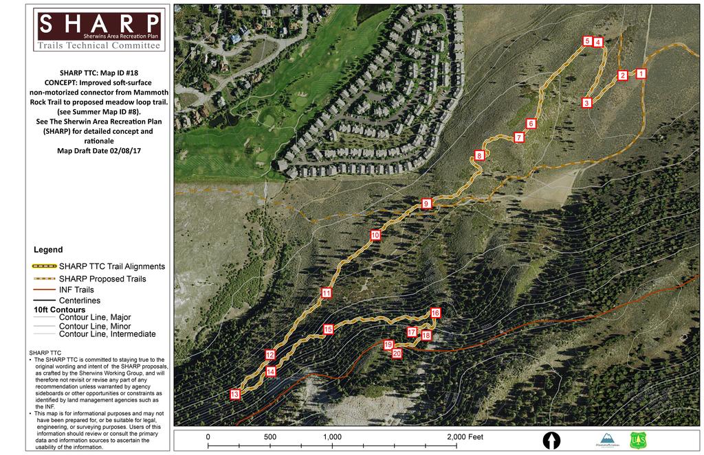
1 Trails Technical Committee Winter 2017 Draft Report Alignment Proposals for the Inyo National Forest and the Town of Mammoth Lakes Map ID #S18 February 08, 2017
2 Map ID #S18 Key Agreements As of February 08, 2017 A. Alignment: This trail is intended to reroute and formalize the existing and unsustainable use trail connection that currently links the central section of the Mammoth Rock Trail to the proposed loop trail around the Sherwins Meadow (SHARP Project ID #08). 1. Trailhead and Destination(s): Mammoth Rock Trail and SHARP Map ID#8. 2. Naming: Meadow Trail Connector 3. Control Points/Narrative: The proposed trail will begin at the intersection of the existing USFS Road AKA 27E201 and SHARP ID #S07 (1). The trail meanders southwest toward the base of the hill, after a short distance the trail meets with SHARP ID #S03 (2) and proceeds to turn northeast in a wide radius turn (3). The alignment continues through manzanita at a 5% grade to the top of the hill and takes another wide radius turn above several beautiful white fir trees (4) and a cluster of large boulders (5) revealing a landscape view of Mammoth Mountain, Mammoth Rock, and Mammoth Pass. The trail proceeds south along the top of the hill through manzanita following a 5% grade past a split boulder (6) revealing sweeping views of Mammoth Mountain, Mammoth Rock, and Mammoth Pass (7). The trail begins to descend from the top of hill and proceeds to flow into a series of wide radius turns. After the first two turns the trail passes an interesting rock feature and reveals another sweeping view of Mammoth Rock and the surrounding area (8). The trail continues through manzanita and crosses an existing use trail (9) and parallels the USFS Road AKA 27E201 as it meanders through clusters of trees. A large rock on this section of the trail may provide a possible side feature for mountain bikes (10). From there the trail maintains a gentle uphill grade through a manzanita grove with rolling contour trail at 2%- 3% grade. The alignment then crosses an existing use trail which will require signage to keep users on the official trail as it continues along the contour (11). A grove of old growth juniper trees (12) is on display near a rock outcropping with a framed window view of Mammoth Mountain and Mammoth Rock as the trail continues to roll along the contour at 5% grade. The trail alignment then meets a large boulder which provides an opportunity to create an interesting turn using the natural shape of the rock (13). The trail then meets a rock slide area with big views (14). There is an opportunity for an alternate rocky alignment above the main route for added interest for more Page 1 of 4
3 experienced trail users (14). The trail continues along the contour, which is now on a steep side slope. The trail will cross the same downhill use trail again (15) near a stand of old growth juniper trees. From there the trail finds a natural opportunity for a wide radius turn into a grove of trees (16). Another wide radius turn yields a big view (17), followed by yet another wide turn (18). The last uphill turn curves around a large tree (19) and the final approach gently merges at a confluence with the Mammoth Rock Trail (20). Signage will be needed to encourage users to stay on the new trail and to not stray onto existing use trails. 4. Map Reference: SHARP TTC: Map ID #S18, 02/08/17 B. Design Specifications: 1. Trail Type: Type 2 (preferred mountain bike; tread narrow less than 36 inches; minimal allowance for passing. See Chapter 6.6 Soft- Surface Trail Design Guidelines from TSMP). 2. Users: Non-motorized users: mountain bikers, day hikers, equestrian 3. Width: See Trail Type. 4. Grade: See Trail Type. 5. Surface: Soft-surface. See Trail Type. 6. Features: The primary feature is to provide a sustainable alternative to existing use/social trails connecting the Mammoth Rock Trail to the Sherwins Meadow and the Sherwins Meadow Trail. Opportunities exist to potentially take advantage of existing social trails and temporary parking areas in the northeastern section of the proposed alignment. 7. User Experience/Aesthetics: This trail is intended to be an easy-tomoderate two-way (uphill and downhill) non-motorized trail connecting SHARP Map ID #08 with the Mammoth Rock Trail. This rolling contour trail with 3%-5% grades will provide an easy to moderate multi-use trail with scenic views and rock features for mountain bikers, day hikers, and equestrians. Making the trail two-way helps to prevent and mitigate possible user conflict between riders coming downhill at higher speeds and users traveling more slowly uphill. This connector will allow mountain bikers to exit the Mammoth Rock Trail before reaching the sandy eastern end (an undesirable soil type for mountain bikers) and connect them back to Town via the Tamarack Street or the Borrow Pit trailheads. This will open loop opportunities in the Sherwins area and on the Mammoth Lakes Trail System for all trail users. 8. Trail Amenities: Viewpoints exist along the route that could be utilized for pullouts taking advantage of the unique geography and scenic opportunities. C. Winter/Summer Interface: None. Page 2 of 4
4 D. Signage and Wayfinding Special Considerations: As noted earlier, specific signage will be needed to keep users on the new trail and not distracted by existing use trails which will need to be rehabilitated by appropriate land management agencies. Signage and wayfinding will be minimal and consistent with the MLTS Wayfinding and Signage Standards Manual. TO BE COMPLETED BY AGENCIES/JURISDICTIONS A. Environmental Review: Anticipated decision from USFS will be a categorical Exclusion per the District Ranger. B. Construction & Maintenance: Town of Mammoth Lakes under CCS and Potentially SUP. C. Funding Considerations & Ownership: Funding Construction through Measure R and MLTS Trail Facilities Construction Reserve Account; Ownership via USFS with Maintenance provided by the MLTS. D. Construction Cost Estimator Total Linear Feet New Trail Construction 8,700 feet Total Estimated Cost per Linear Foot $5.00 Total Estimated Cost of New Trail Construction $43,400 Type of Amenities Type 9a Signage # of Amenities 5 Cost per Amenity $200 Total Cost of Amenities $1,000 Rehabilitation Cost N/A Total Cost Estimate for SHARP ID #S18 $44,500 a. Total linear feet of new trail construction: 8,700 feet b. Total estimated cost per linear foot: approx. $5.00 c. Estimated Cost of Amenities: $1,000 for Type 9a signage. A minimum of four Type 9a (Trail Directional) signs will be needed on this trail: one at the trailhead (control point 1), two at intersections with existing use trail to keep users on the trail, one near the rock slide for the alternative rocky alignment for experienced users, and at the end of the trail where it meets the Mammoth Rock Trail. Signs are approximately $200 each, the estimated signage budget for this trail will be $1,000. d. Rehabilitation cost estimate: N/A e. First-guess cost estimate: $44,500 i. Preferred Alignment: $44,500 Page 3 of 4
5 ii. Alternative alignment: None E. Other Special Considerations: SHARP ID #08 needs to be formalized as a USFS System Trail prior to construction of SHARP ID #S18. Hand tools will likely be the primary means of construction for this trail, and are desired to reinforce the character of the finished product. Page 4 of 4
6

7 Project Cover Sheet: Map ID #S18 SHARP CONCEPT SHARP RATIONALE RELATED PROJECTS WORKFLOW CHECKLIST TASK Group overview in-house meeting to present work plan and desired Group overview field trip and technical analysis in-house Drafting/staking Technical review field trip Draft revision Final review meeting Presentation to USFS AGENCY TBD SIDEBOARDS DESIRED OUTSIDE PARTICIPANTS ENVIRONMENTAL REVIEW OTHER NOTES PARTICIPANTS Improved soft-surface non-motorized connector from Mammoth Rock Trail to proposed meadow loop trail (See Summer Map ID #8). Improve the existing trail connection that links the eastern section of Mammoth Rock Trail to the loop trail around the meadow (see Summer Map ID #8). The connector will be clearly delineated and marked as two-way (uphill and downhill), utilize the existing use-trail, which is currently in good shape except for the top portion, and will be open to non-motorized use only. Equestrian use will be accommodated per appropriate and sustainable design needs of the topography and terrain, which could include a second trail. This connector will allow mountain bikers to exit the Mammoth Rock Trail before reaching the sandy eastern end (an undesirable soil type for mountain bikers) and can connect them via the backbone trails to the Tamarack Street trailhead (see Summer Map ID #2 and #7). This link will open up loop opportunities both within the Sherwins area and on Mammoth Lakes Trail System facilities accessible from the Tamarack Street trailhead and the borrow pit staging area (see Summer Map ID #1). Making the trail two-way helps to prevent and mitigate user conflict between riders coming downhill at higher speeds and users traveling more slowly upslope. SHARP project ID #1 - See the SHARP Summer Proposal for details. SHARP project ID #2 - See the SHARP Summer Proposal for details. SHARP project ID #7 - See the SHARP Summer Proposal for details. SHARP project ID #8 - See the SHARP Summer Proposal for details. DATE COMPLETED September 17, 2015 September 23, 2015 October 16, 2015 September 7, 2016 November 2, 2015 December 30, 2015 January 4, 2016 Town of Mammoth Lakes, Inyo National Forest NEPA: Anticipated decision from USFS will be a Categorical Exclusion per the District Ranger. Specific action still pending. TBD CEQA: TBD Participants: Alan Jacoby, Joel Rathje, Jamie Rathje, John Wentworth, Andrew Mulford, and Kelly Workman. DRAFT - 17/02/08 1 of 1
Trail Phasing Plan. Note: Trails in the Clear Creek Canyon area (Segments will be finalized in the future to minimize wildlife impacts
 Note: Trails in the Clear Creek Canyon area (Segments 2 5 and a future JCOS connection) will be finalized in the future to minimize wildlife impacts Trail Phasing Plan P Parking 3 Easy Trail Intermediate
September 14, Comments of the Colorado Trail Foundation On the USFS Scoping Notice of August 13, 2010 RE: the relocation of the CDNST/CT Page 1
 THE COLORADO TRAIL FOUNDATION Comments on the U.S. Forest Service Scoping Notice of August 13, 2010 Regarding the Relocation of THE COLORADO TRAIL AND CONTINENTAL DIVIDE NATIONAL SCENIC TRAIL From La Garita
AGENDA BILL. David Wilbrecht, Town Manager Stuart Brown, Recreation Manager
 AGENDA BILL Agenda Item I I February 1, 2012 File No. (ZiZ~. ~ -(O-- to Subject: Resolution to establish and formalize a high level of interagency cooperation with the USDA Inyo National Forest to plan,
Trail Assessment Report
 Trail Assessment Report Trail Options for the Bear Creek Canyon located in Pikes Peak Ranger District, Pike National Forest and on Colorado Springs Utility Lands Due to the presence of a unique species
APPENDIX D: SUSTAINABLE TRAIL DESIGN. APPENDICES Town of Chili Parks and Recreation Master Plan Update
 APPENDIX D: SUSTAINABLE TRAIL DESIGN APPENDICES Town of Chili Parks and Recreation Master Plan Update Sustainable Trail Construction Sustainable trails are defined by the US Forest Service as trails having
GATEWAY PHASE 2. U.S. Forest Service and the Mount Shasta Trails Association
 GATEWAY PHASE 2 U.S. Forest Service and the Mount Shasta Trails Association PROJECT DEVELOPMENT Brief history - Gateway Phase 1 - IMBA conceptual plan - BikeShasta: concert series - USFS & MSTA partnered
TOWN OF MAMMOTH LAKES Soft-Surface Trails Concept
 TOWN OF MAMMOTH LAKES Soft-Surface Trails Concept Presented by Trail Solutions July 2008 1 1. INTRODUCTION A. Document Purpose.The Town of Mammoth Lakes (TOML or Town), and its planning partners, recognized
ROAD AND TRAIL PROJECT APPROVAL
 ROAD AND TRAIL PROJECT APPROVAL www.marincountyparks.org Marin County Parks, 3501 Civic Center Dr, Suite 260, San Rafael, CA 94903 DATE: July 12, 2017 PRESERVE: Gary Giacomini Open Space Preserve PROJECT:
Kelly Motorized Trails Project Proposed Action
 Kelly Motorized Trails Project Proposed Action November 28, 2011 The Flagstaff Ranger District of the Coconino National Forest is seeking public input on the proposed Kelly Motorized Trails Project (formerly
TOWN OF MAMMOTH LAKES (TOML) Soft-Surface Trails Concept. December With Support from Trail Solutions
 Soft-Surface Trails Concept. December With Support from Trail Solutions") TOWN OF MAMMOTH LAKES (TOML) Soft-Surface Trails Concept December 2008 With Support from Trail Solutions 1 1. BACKGROUND & INTRODUCTION A. Background The Town of Mammoth Lakes adopted a Trail System Plan
TOWN OF MAMMOTH LAKES (TOML) Soft-Surface Trails Concept December 2008 With Support from Trail Solutions 1 1. BACKGROUND & INTRODUCTION A. Background The Town of Mammoth Lakes adopted a Trail System Plan
Buford / New Castle Motorized Trail
 Buford / New Castle Motorized Trail Rifle Ranger District, White River National Forest Garfield County, Colorado Comments Welcome The Rifle Ranger District of the White River National Forest welcomes your
Appendix 3. Greenway Design Standards. The Whitemarsh Township Greenway Plan
 Appendix 3 Greenway Design Standards This chapter discusses two design standards for the greenway types discussed above. First, trail design standards are presented together with trailhead facilities and
The Chu property is a 6.57 acre parcel located in the Town of Superior on the west side of McCaslin Boulevard. In 2014, the Town of Superior acquired
 1 The Chu property is a 6.57 acre parcel located in the Town of Superior on the west side of McCaslin Boulevard. In 2014, the Town of Superior acquired the Chu property for open space with a contribution
Logo Department Name Agency Organization Organization Address Information 5700 North Sabino Canyon Road
 Logo Department Name Agency Organization Organization Address Information United States Forest Coronado National Forest 5700 North Sabino Canyon Road Department of Service Santa Catalina Ranger District
EXECUTIVE SUMMARY PROGRAM DEVELOPMENT REPORT PURPOSE EXISTING SETTING EXPANDING PARKLAND
 EXECUTIVE SUMMARY PROGRAM DEVELOPMENT REPORT PURPOSE As the culmination of the first phase of the master planning process, this Program Development Report creates the framework to develop the Calero County
Hudson Highlands Fjord Trail Draft Master Plan. April 29, 2015
 Hudson Highlands Fjord Trail Draft Master Plan April 29, 2015 Agenda Route Overview Proposed Segment Results of Community Survey on that Segment Next Steps Municipal Endorsement Environmental Review Implementation
Stephens State Park Trails
 TRAILS OF ALLAMUCHY MOUNTAIN & STEPHENS STATE PARKS Allamuchy Mountain and Stephens State Parks contain 28 marked trails providing access to diverse landscapes for walking, hiking, biking, bird-watching,
Proposed Project 1: Kimble Loop East Horse Trail Reroute (1). Horse Trail Reroute: March 14, 2012
. Horse Trail Reroute: March 14, 2012") Proposed Project 1: Kimble Loop East Horse Trail Reroute The Ironton District Ranger requests your comments on proposed trail project on National Forest System lands. (1). Horse Trail Reroute: The proposed
Proposed Project 1: Kimble Loop East Horse Trail Reroute The Ironton District Ranger requests your comments on proposed trail project on National Forest System lands. (1). Horse Trail Reroute: The proposed
Form for Project Descriptions - December 2013 version! 1. Stone Valley Cooperative Recreation Area (SVCRA) Project Description
 Project Description") Form for Project Descriptions - December 2013 version 1 Stone Valley Cooperative Recreation Area (SVCRA) Project Description The Stone Valley partners request that proposed work on land within the SVCRA
Form for Project Descriptions - December 2013 version 1 Stone Valley Cooperative Recreation Area (SVCRA) Project Description The Stone Valley partners request that proposed work on land within the SVCRA
MOAB peopleforbikes.org/e-bikes
 emtb ADVENTURE MAPS MOAB peopleforbikes.org/e-bikes OVERVIEW Moab, Utah is a world-class mountain bike destination known for its vast, red sandstone landscapes nestled below the rising peaks of the La
Daisy Dean Trail 628/619 ATV Trail Construction
 Background and Purpose and Need The Daisy Dean ATV Trail Construction Project is located in the Little Belt Mountains, Musselshell Ranger District, Lewis and Clark National Forest approximately 32 miles
LAS VARAS RANCH CA COASTAL TRAIL PROPOSED ALIGNMENT
 LAS VARAS RANCH CA COASTAL TRAIL PROPOSED ALIGNMENT Santa Barbara Trails Council * Prepared by Ray Ford February 1,2012 The following notes accompany the Santa Barbara Trails Council map for the Las Varas
Understanding user expectations And planning for long term sustainability 1
 Understanding user expectations And planning for long term sustainability 1 What is a natural surface trail? It can be as simple has a mineral soil, mulched or graveled pathway, or as developed as elevated
Thank you for the opportunity to comment on the proposed action to add trails and trailheads to the Red Rock District trail system.
 July 14, 2010 Jennifer Burns Red Rock Ranger District PO Box 20429 Sedona, AZ 86341 Flagstaff Biking Organization PO Box 23851 Flagstaff, AZ 86002 Dear Jennifer- Thank you for the opportunity to comment
CHAPTER III: TRAIL DESIGN STANDARDS, SPECIFICATIONS & PERMITS
 CHAPTER III Trail Design Standards, Specifications & Permits This chapter discusses trail standards, preferred surface types for different activities, permits, and other requirements one must consider
FEASIBILITY CRITERIA
 This chapter describes the methodology and criteria used to evaluate the feasibility of developing trails throughout the study areas. Land availability, habitat sensitivity, roadway crossings and on-street
Thank you for the opportunity to comment on the Mount Elden/Dry Lake Hills Recreation Planning Proposed Action, (MEDL).
.") November 27, 2014 Brian Poturalski Recreation and Wilderness Staff Officer Flagstaff Ranger District Coconino National Forest 5075 N. Highway 89 Flagstaff, AZ 86004 comments-southwestern-coconino-flagstaff@fs.fed.us
November 27, 2014 Brian Poturalski Recreation and Wilderness Staff Officer Flagstaff Ranger District Coconino National Forest 5075 N. Highway 89 Flagstaff, AZ 86004 comments-southwestern-coconino-flagstaff@fs.fed.us
Preferred Recreation Recommendations Stemilt-Squilchuck Recreation Plan March 2018
 Preferred Recreation Recommendations Stemilt-Squilchuck Recreation Plan March 2018 Below are the recommended recreation ideas and strategies that package together the various recreation concepts compiled
Trail Beginning Elevation: 7553 ft The Poison Creek Trailhead is located at the end of National Forest Road 646E (NF-646E).
.") West Mountain Trails Poison Creek Trail #134 Length: 2.9 miles (4.7 km) Difficulty Horseback: A good trail for the first time west mountain rider, some steep sections Hiking: Most Difficult USGS Maps:
West Mountain Trails Poison Creek Trail #134 Length: 2.9 miles (4.7 km) Difficulty Horseback: A good trail for the first time west mountain rider, some steep sections Hiking: Most Difficult USGS Maps:
Tracy Ridge Shared Use Trails and Plan Amendment Project
 Tracy Ridge Shared Use Trails and Plan Amendment Project Scoping Document Forest Service Allegheny National Forest Bradford Ranger District McKean, County, Pennsylvania In accordance with Federal civil
Non-motorized Trail Plan & Proposal. August 8, 2014
 Town of Star Valley Ranch, Wyoming and the Star Valley Ranch Association in partnership with the USDA Forest Service, Bridger-Teton National Forest, Greys River Ranger District Non-motorized Trail Plan
Memo. Board of County Commissioners. FROM: Tamra Allen, Planner. Buford/New Castle Motorized Trail. Date: February 13, 2012
 Memo TO: Board of County Commissioners FROM: Tamra Allen, Planner RE: Buford/New Castle Motorized Trail Date: February 13, 2012 Overview The White River National Forest Rifle District Office ( RDO ) issued
PROPOSED ACTION South 3000 East Salt Lake City, UT United States Department of Agriculture
 United States Department of Agriculture Forest Service Uinta-Wasatch-Cache National Forest Salt Lake Ranger District 6944 South 3000 East Salt Lake City, UT 84121 801-733-2660 File Code: 1950/2300 Date:
Longmont to Boulder Regional Trail Jay Road Connection DRAFT FINAL REPORT
 Longmont to Boulder Regional Trail Jay Road Connection DRAFT FINAL REPORT December 2018 Project Summary Boulder County, Colorado, in partnership with the City of Boulder, is evaluating options for multi-use
Business Item No
 Metropolitan Parks and Open Space Commission Meeting date: February 6, 2018 For the Community Development Committee meeting of February 20, 2018 For the Metropolitan Council meeting of February 28, 2018
Mickelson Connector Feasibility Study
 Friends of the Norbeck PO Box 2003 Rapid City, SD 57709 www.friendsofthenorbeck.org Summary Comments on the Mickelson Connector Feasibility Study Prepared by Brian Brademeyer Submitted to Wyss Associates
LANDER AREA MASTER TRAILS PLAN. Lander Cycling Club November 2012
 LANDER AREA MASTER TRAILS PLAN Lander Cycling Club November 2012 Table of Contents A. Overview 3 B. Introduction 4 C. Visitor Profile 5 D. Benefits to the Community 6 E. Area wide Goals and Objectives
Table of Contents. page 3 Long term Goals Project Scope Project History. 4 User Groups Defined Trail Representative Committee. 5 Trail Users Breakdown
 Launched April 27th, 2010 1 Table of Contents page 3 Long term Goals Project Scope Project History 4 User Groups Defined Trail Representative Committee 5 Trail Users Breakdown 13 Trail Users Desires 16
Nov. 19 th Public Workshop Summary
 On November 19 th, more than 60 community members attended an Open Space Matters workshop at the Linen Building in downtown Boise for over two hours. Participants learned about reserves, discussed the
RUSHMORE CONNECTOR TRAIL PROPOSAL
 PURPOSE AND NEED Background The U.S. Forest Service, Black Hills National Forest (Forest Service) has received a special use permit application from the State of South Dakota Department of Game, Fish and
To: Cam Hooley From: Trails 2000 Date: September 30, 2016 Re: Hermosa Comments. Dear Cam:
 ! To: Cam Hooley From: Trails 2000 Date: September 30, 2016 Re: Hermosa Comments Dear Cam: Trails 2000 is commenting on the Forest Service Management Plan for the Hermosa Creek Watershed Management Plan
CHAPTER 5. Chapter 5 Recreation Element
 CHAPTER 5 Recreation Element Chapter 5 Recreation Element The Recreation Element of the Meyers Area Plan is a supplement to the Recreation Element of the TRPA Regional Plan and the El Dorado County General
Business Item No XXX. Proposed Action That the Metropolitan Council approve the Coon Creek Regional Trail Master Plan.
 Business Item No. 2015-XXX Metropolitan Parks and Open Space Commission Meeting date: July 7, 2015 For the Community Development Committee meeting of July 20, 2015 For the Metropolitan Council meeting
2. STAKEHOLDER FEEDBACK // What We Heard
 1. QUARRY ROAD TRAIL // Welcome to the Information Session PROJECT DESCRIPTION WHY WE ARE HERE Quarry Road Trail is a popular commuter trail and recreational area for Calgarians. 1. To report citizen feedback
16.5 Mile Trek Guide. Chief Pontiac Trail Credential Hikes RDS.H
 16.5 Mile Trek Guide Chief Pontiac Trail Credential Hikes RDS.H.110609 WP# Dist. Feet Accum. Miles Dist. Meters Accum. Meters 1 0 0.0 0 0 2 961 0.2 293 293 3 820 0.3 250 543 4 866 0.5 264 807 4a 407 0.6
Bear Creek Habitat Improvement Project
 06/10/10 Bear Creek Habitat Improvement Project El Paso County, Colorado Pike National Forest and Colorado Springs Utilities Owned Land Report prepared by: Eric Billmeyer Executive Director Rocky Mountain
Mt. Hood National Forest
 United States Department of Agriculture Forest Service Mt. Hood National Forest Zigzag Ranger District 70220 E. Highway 26 Zigzag, OR 97049 503-622-3191 Fax: 503-622-5622 File Code: 1950-1 Date: June 29,
GOLDEN EARS PROVINCIAL PARK
 GOLDEN EARS PROVINCIAL PARK Trail Information as of October 10 th 2015 Do not underestimate the mountainous wilderness of Golden Ears Provincial Park. The combination of rugged terrain and rapidly changing
Marin County Department of Parks and Open Space
 Marin County Department of Parks and Open Space 680 Trail Shared-Use Trail Design Analysis View from Proposed 680 Trail Alignment Prepared by:, LLC 1632 Ocean View Avenue, Kensington, CA 94707 USA info@hilride.com
beach. Make the ford and follow the trail out to the junction with Red Creek Tr in an open grassy area.
 Description: This is a moderate to slightly strenuous 22.8 mile backpack (add 2.6 miles if you do the packless out and back to the Lion s Head) that will have you exploring nearly every thing that is The
Snowmobile Trail Signing REF: DNR Trail Signing Handbook
 AWSC FALL WORKSHOP TRAIL SIGNING & MAINTENANCE NOVEMBER 5, 2011 Workshop presenters: Larry Erickson, AWSC Trails Committee Chairman, Iron County Director Dave Peterson, Langlade County Director Snowmobile
National Recreation Trail Update Form
 National Recreation Trail Update Form Introduction Thank you for taking the time to complete this form. Your assistance will help ensure that the National Recreation Trail (NRT) database is complete and
CAMELBACK MOUNTAIN: CHOLLA TRAIL
 CITY OF PHOENIX :: Camelback Mountain: Cholla T rail 21 CAMELBACK MOUNTAIN: CHOLLA TRAIL IN BRIEF Camelback Mountain is the tallest point in the city of Phoenix. From the 2,704-foot summit of Camelback,
Proposed Peninsula Bay Bike Track Development
 Proposed Peninsula Bay Bike Track Development May 2018 BACKGROUND The area of land at the northern extreme of Wanaka's Peninsula Bay development (Lot 923 DP 501325), currently owned by Infinity Investment
Chapter 4.0 Alternatives Analysis
 Chapter 4.0 Alternatives Analysis Chapter 1 accumulated the baseline of existing airport data, Chapter 2 presented the outlook for the future in terms of operational activity, Chapter 3 defined the facilities
DECISION MEMO. Rawhide Trail #7073 Maintenance and Reconstruction
 Page 1 of 6 Background DECISION MEMO USDA Forest Service Jefferson Ranger District Jefferson County, Montana Rawhide Trail #7073 is located in the Elkhorn Mountain Range approximately 10 miles east of
Chatsworth Branch Library Devonshire Street, Chatsworth, CA Thursday, November 16, :00-8:00 pm
 Chatsworth Branch Library 21052 Devonshire Street, Chatsworth, CA 91311 Thursday, November 16, 2017 6:00-8:00 pm Project Team County of Los Angeles Department of Parks and Recreation Kathline King Chief
DATE: 23 March, 2011 TO: Communities FROM: BlazeSports America. RE: Accessible Trails Checklist 1
 M E M O R A N D U M DATE: 23 March, 2011 TO: Communities FROM: BlazeSports America RE: Accessible Trails Checklist 1 The purpose of the Accessible Trails Checklist (below) is to help the community review
Lawrence Loop SWOT Analysis
 Alignment: D1 (Map Color: Dark Blue) Description: This alignment connects to the north end of the Burroughs Creek Trail and continues along the west side of the Railroad to 8 th Street. Strengths: - This
City of Durango 5.8 FUNDING TRAILS DEVELOPMENT
 5.8 FUNDING TRAILS DEVELOPMENT The City has been successful in establishing dedicated local funding sources as well as applying for grants to develop the City s trail system, having received nearly $2.4
Stevenson Ranch Library The Old Road, Stevenson Ranch, CA Thursday, November 9, :00-8:00 pm
 Stevenson Ranch Library 25950 The Old Road, Stevenson Ranch, CA 91381 Thursday, November 9, 2017 6:00-8:00 pm Project Team County of Los Angeles Department of Parks and Recreation Kathline King Chief of
Rocky Mountain Field Institute
 Rocky Mountain Field Institute Palmer Park Stewardship Project 2016 Annual Project Report December 20, 2016 Report prepared by: Andy Riter, Program Coordinator and Alex Hladkyj, Field Instructor 815 South
MASTER PLAN EXECUTIVE SUMMARY
 Biscuit Run State Park Scottsville Road (State Route 20) Charlottesville, VA 22902 Biscuit Run State Park MASTER PLAN EXECUTIVE SUMMARY Department of Conservation and Recreation Division of Planning and
Discussion Paper: Development of a Plan for Trails on Public Land
 Discussion Paper: Development of a Plan for Trails on Public Land APRIL 2017 The purpose of this Discussion Paper is to summarize the status & issues relating to District trails and feedback to date, and
Becker County Trail Routing Feasibility Study
 2016 Becker County Trail Routing Feasibility Study CONNECTING DETROIT MOUNTAIN AND MOUNTAIN VIEW RECREATIONAL AREA TO THE HEARTLAND TRAIL BECKER COUNTY ULTEIG ENGINEERS Contents Acknowledgements...2 INTRODUCTION...3
Project Planning, Compliance, and Funding
 Project Planning, Compliance, and Funding The plans above offer high level guidance to ensure that the A.T. is managed effectively as a whole unit in a decentralized management structure. Cooperative management
Committee Report. Community Development Committee For the Metropolitan Council meeting of August 12, Business Item No.
 Committee Report Business Item No. 2015-168 Community Development Committee For the Metropolitan Council meeting of August 12, 2015 Subject: Coon Creek Regional Trail Master Plan, Anoka County Proposed
BRYCE CANYON COUNTRY Boulder Mountain Scenic backways itinerary
 BRYCE CANYON COUNTRY Boulder Mountain Scenic backways itinerary Boulder Mountain Area The high plateaus of the Aquarius Plateau (Boulder Mountain), are heavily forested and covered in countless winding
Decision Memo for Desolation Trail: Mill D to Desolation Lake Trail Relocation
 for Salt Lake County, Utah Uinta-Wasatch-Cache National Forest Salt Lake Ranger District 1. Background The present location of the Desolation Trail (#1159) between Mill D and Desolation Lake follows old
New Mountain Bike Trails Proposal. Wharncliffe Woods- Sheffield
 New Mountain Bike Trails Proposal. Wharncliffe Woods- Sheffield Overview We propose to create two new cross country trail within Wharncliffe woods, one to replace the existing black trail, which has become
FINAL. Bicycle/Pedestrian Feasibility Study City of DeBary Dirksen Drive Trail. Prepared For: Volusia County MPO
 City of DeBary Dirksen Drive Trail FINAL Prepared By: Reynolds, Smith and Hills, Inc. Prepared For: Volusia County MPO September 2007 Table of Contents INTRODUCTION...1 PROJECT PURPOSE AND SCOPE...2 PHYSICAL
IDAHO STATE ATV ASSOCIATION, INC. an Idaho nonprofit corporation. GUIDELINES FOR DETERMINING TRAIL DIFFICULTY [adopted August 8, 2015]
![IDAHO STATE ATV ASSOCIATION, INC. an Idaho nonprofit corporation. GUIDELINES FOR DETERMINING TRAIL DIFFICULTY [adopted August 8, 2015]](/thumbs/81/83102183.jpg "IDAHO STATE ATV ASSOCIATION, INC. an Idaho nonprofit corporation. GUIDELINES FOR DETERMINING TRAIL DIFFICULTY [adopted August 8, 2015]") IDAHO STATE ATV ASSOCIATION, INC. an Idaho nonprofit corporation GUIDELINES FOR DETERMINING TRAIL DIFFICULTY [adopted August 8, 2015] U The following represent the official guidelines for determining trail
IDAHO STATE ATV ASSOCIATION, INC. an Idaho nonprofit corporation GUIDELINES FOR DETERMINING TRAIL DIFFICULTY [adopted August 8, 2015] U The following represent the official guidelines for determining trail
College Forests Recreation Planning Focus Group Results Summary, Spring 2013
 Broad Themes by Prevalence 1) Trails 2) University Relations & Management 3) User Conflict 4) Access 5) Use Types and Extent 6) Ecology 7) Change 8) Information & Education College Forests Recreation Planning
National Recreation Trail Application for Designation
 National Recreation Trail Application for Designation Introduction Thank you for your interest in the National Recreation Trail (NRT) program. Completed NRT application packages must be submitted by December
Understanding the caring capacity of the visitor experience Provide facilities to support a high level user experience Address visual quality through
 Understanding the caring capacity of the visitor experience Provide facilities to support a high level user experience Address visual quality through recreation ecological restoration opportunities Collaboration
COASTAL CONSERVANCY. Staff Recommendation September 22, 2011 BAY AREA RIDGE TRAIL: HOOD MOUNTAIN TO HIGHWAY 12
 COASTAL CONSERVANCY Staff Recommendation September 22, 2011 BAY AREA RIDGE TRAIL: HOOD MOUNTAIN TO HIGHWAY 12 File No. 11-039-001 Project Manager: Betsy Wilson RECOMMENDED ACTION: Authorization to disburse
West Trails Trek Guide. Chief Pontiac Trail Credential Hikes
 West Trails Trek Guide Kensington Start Edition Chief Pontiac Trail Credential Hikes RDS.WTW.110609 WP# Dist. Accum. Dist. Accum. Feet Miles Meters Meters 1 0 0.0 0 0 2 410 0.1 125 125 3 164 0.1 150 275
Dixon Trail Construction - From the Top of the Mountain 2016 Interim Report Friends of Cheyenne Mountain State Park September 2 nd, 2016
 - Dixon Trail Construction - From the Top of the Mountain 2016 Interim Report Friends of Cheyenne Mountain State Park September 2 nd, 2016 Prepared by: Andy Riter, Program Coordinator, and Joe Lavorini,
Dungeness Recreation Area County Park Master Plan
 Dungeness Recreation Area County Park Public Outreach Meeting October 10, 2007 Project Overview USFWS Site Dungeness Recreation Area County Park Meeting Objectives: Re-Introduce project; provide status
PLANNING COMMISSION AGENDA REPORT May 10, Members of the Planning Commission. Joyce Parker-Bozylinski, Contract Planner
 PLANNING COMMISSION AGENDA REPORT May 10, 2007 TO: FROM: PROPOSAL: APPLICANT: RECOMMENDATION: Members of the Planning Commission Joyce Parker-Bozylinski, Contract Planner Approval of the Calabasas Trails
ANCLOTE COASTAL TRAIL ALTERNATIVES ANALYSIS STUDY
 ANCLOTE COASTAL TRAIL ALTERNATIVES ANALYSIS STUDY PASCO COUNTY MPO JULY 2015 PROJECT OVERVIEW... INTRODUCTION EXECUTIVE SUMMARY CONTEXT... TAMPA BAY AREA, PINELLAS, & PASCO COUNTY S MULTI-USE TRAIL PLANS
Rogue Gorge (Mt. Stella) Roadless Area-- T30S R3E (primarily in portions of Sections 23, 26, 33, 34 & 35)
 Roadless Area-- T30S R3E (primarily in portions of Sections 23, 26, 33, 34 & 35)") Rogue Gorge (Mt. Stella) Roadless Area-- T30S R3E (primarily in portions of Sections 23, 26, 33, 34 & 35) Rogue River-Siskiyou National Forest--High Cascades Ranger District Upper, higher elevation trail
Rogue Gorge (Mt. Stella) Roadless Area-- T30S R3E (primarily in portions of Sections 23, 26, 33, 34 & 35) Rogue River-Siskiyou National Forest--High Cascades Ranger District Upper, higher elevation trail
FOREST SERVICE HANDBOOK NATIONAL HEADQUARTERS (WO) WASHINGTON, DC
 WASHINGTON, DC") Page 1 of 48 FOREST SERVICE HANDBOOK NATIONAL HEADQUARTERS (WO) WASHINGTON, DC Amendment No.: 2309.18-2008-4 Effective Date: October 16, 2008 Duration: This amendment is effective until superseded or removed.
Page 1 of 48 FOREST SERVICE HANDBOOK NATIONAL HEADQUARTERS (WO) WASHINGTON, DC Amendment No.: 2309.18-2008-4 Effective Date: October 16, 2008 Duration: This amendment is effective until superseded or removed.
Chapter 6. Trail Design. Trail Design
 Chapter 6 Trail Design Trail Design The trail winds through a region rich in scenic beauty, cultural, and natural history. Volunteer landscape architects working with the Core and Planning Teams, have
Section 3.6 Recreation
 3.6 RECREATION This section evaluates the potential impacts of the proposed project on recreation within MTRP. The evaluation is based on field observations, a review of maps of MTRP and the MTRP Master
Great Pond Mountain Conservation Trust Request for Bids Wildlands Hillside Trail Relocation and Restoration Project
 Great Pond Mountain Conservation Trust Request for Bids Wildlands Hillside Trail Relocation and Restoration Project Project Description: Great Pond Mountain Conservation Trust (GPMCT), a nonprofit land
San Luis Obispo. Bishop Peak Felsman Loop Eagle Rock Maino Open Space Poly Canyon Poly P Other Areas
 San Luis Obispo Bishop Peak Felsman Loop Eagle Rock Maino Open Space Poly Canyon Poly P Other Areas 1 JCT. ELEV. 72 400 00 0 FELSMAN LOOP GATE LOOP RIDGE 600 FENCE JCT. ELEV. 860 1000 1200 BISHOP PEAK
Camper Cabins in National Forest Campgrounds. Jon Benson Recreation Specialist USDA Forest Service Superior National Forest
 Camper Cabins in National Forest Campgrounds Jon Benson Recreation Specialist USDA Forest Service Superior National Forest Superior National Forest The Superior National Forest is known locally, regionally,
YOSEMITE ON HORSEBACK: THREE RIDES ALONG TIOGA ROAD Cindy Casey White Wolf Area, May Lake Loop, Ragged Peak Loop
 YOSEMITE ON HORSEBACK: THREE RIDES ALONG TIOGA ROAD Cindy Casey White Wolf Area, May Lake Loop, Ragged Peak Loop The high country along Tioga Road presents us with some of the most dramatic scenery in
5.0 OUTDOOR RECREATION OPPORTUNITIES AND MANAGEMENT
 5.0 OUTDOOR RECREATION OPPORTUNITIES AND MANAGEMENT 5.1 Introduction This section describes the range of recreational activities that currently take place in Marble Range and Edge Hills Parks, as well
DAKOTA CULTURE UPPER SIOUX COMMUNITY: AREA CHARACTER ANALYSIS ALIGNMENT STRATEGY
 UPPER SIOUX COMMUNITY: AREA CHARACTER ANALYSIS ALIGNMENT STRATEGY 51 AREA CHARACTER ANALYSIS: OPPORTUNITIES & CONSTRAINTS RECREATIONAL VEHICLE PARK: A recreational vehicle park will be built to accommodate
PRESERVE TRAIL GUIDELINES Resource Management Guidelines for Trails in Preserves
 PRESERVE TRAIL GUIDELINES Resource Management Guidelines for Trails in Preserves County of San Diego Department of Parks and Recreation April 2018 sdparks.org Table of Contents CHAPTER 1: INTRODUCTION...
Committee Report. Community Development Committee For the Metropolitan Council meeting of April 13, Business Item No.
 Committee Report Business Item No. 2016-48 Community Development Committee For the Metropolitan Council meeting of April 13, 2016 Subject: Harriet Island-South St. Paul Regional Trail Master Plan, Saint
Blue River Trail Master Plan JSA to Town Hall June 2004
 Blue River Trail Master Plan JSA to Town Hall June 2004 Prepared for: Silverthorne Town Council Silverthorne SPORT Committee Department of Recreation and Culture Silverthorne Public Works Silverthorne
Citrus Heights Creek Corridor Trail Project. Trail Advisory Group Meeting #3 July 8, 2013
 Citrus Heights Creek Corridor Trail Project Trail Advisory Group Meeting #3 July 8, 2013 Agenda Introductions Recap: Community Workshop, Survey Findings, and TAG Field Trip Community Concern Discussion:
Telluride-to-Moab Alternative Singletrack Options
 Telluride-to-Moab Alternative Singletrack Options Day 1 Day 1 Alternate 1: Galloping Goose to Deep Creek. 18.4 miles, ascent 3,530ft, descent 1,388ft. This is fun, flowey, moderate to intermediate singletrack
Trail Management Objectives (TMO s)
") Trail Management Objectives (TMO s) TMO s are the foundation for solid, consistent trail planning, survey & design, construction, maintenance, periodic condition assessment & prescriptions, and on-going
Trail Management Objectives (TMO s) TMO s are the foundation for solid, consistent trail planning, survey & design, construction, maintenance, periodic condition assessment & prescriptions, and on-going
Minnesota Off-Road Cyclists
 Minnesota Off-Road Cyclists MORC Mission Minnesota Off-Road Cyclists is a nonprofit volunteer organization dedicated to safeguarding the future of mountain biking in Minnesota through the promotion of
INTRODUCTION. Mailing address: Burke County Community Development Attn: Tim Johnson P. O. Box 219 Morganton, NC
 REQUEST FOR QUALIFICATIONS: PROFESSIONAL, EXPERIENCED TRAIL BUILDERS FOR THE CONSTRUCTION OF THE FONTA FLORA STATE TRAIL LAKE JAMES SECTION BURKE COUNTY COMMUNITY DEVELOPMENT INTRODUCTION Burke County
Decision Memo Broken Wheel Ranch Equestrian Outfitter Special-Use Permit Proposed Action
 Decision Memo Broken Wheel Ranch Equestrian Outfitter Special-Use Permit USDA Forest Service Mississippi Bluffs Ranger District, Shawnee National Forest Jackson and Union Counties, Illinois Proposed Action