Lawrence Loop SWOT Analysis
|
|
|
- Meredith Garrett
- 5 years ago
- Views:
Transcription
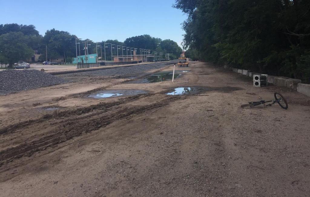
1 Alignment: D1 (Map Color: Dark Blue) Description: This alignment connects to the north end of the Burroughs Creek Trail and continues along the west side of the Railroad to 8 th Street. Strengths: - This alignment avoids conflicts with a majority of the streets and driveways in the area. - This route is fairly flat and avoids the hill that alignment D2 crosses. Weaknesses: - About half of this alignment is adjacent to the railroad which has the possibility to create safety concerns and noise, dust and other nuisance concerns. Opportunities: - This route could reclaim some of the abandoned railroad area and clean the area up. There is a substantial amount of trash and dumping happening in the area. Threats: - The majority of this route is aligned on Railroad property. An agreement with the Railroad would be necessary to allow this route to be constructed as shown. Section Statistics: - Approximate Length 2,270 ft. - Residential Driveway Crossings 0 - Commercial Driveway Crossings 1 - At-Grade Street Crossings 0 - Pedestrian/Bicycle Crashes ( ) N/A - Adjacent Roadway Speed Limit N/A - Adjacent Roadway Average Annual Daily Traffic N/A Page 1 of 12
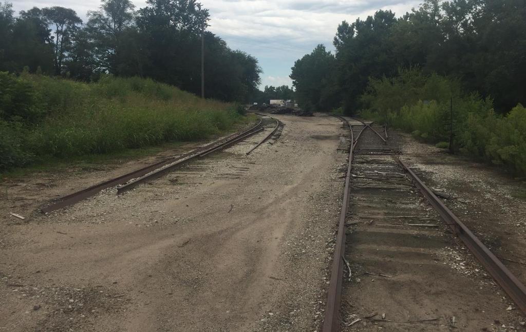
2 Alignment: D1 Page 2 of 12
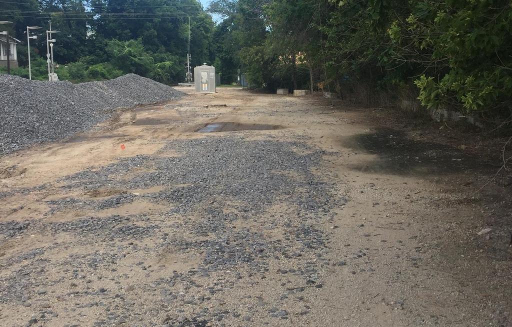
3 Alignment: D2 (Map Color: Light Blue) Description: This alignment connects to the north end of the Burroughs Creek Trail and continues along the north side of 11 th Street to the east edge of Hobbs Park. The route continues north along the east side of the Hobbs ballfield crossing 10 th Street and running along the west side of the Allen Press property until it intersects with Delaware Street. The alignment continues along the east side of Delaware Street until it intersects 8 th Street. Strengths: - A majority of this route already has established sidewalks or paths although the desired width of 10 is generally not present. Weaknesses: - The route has a fairly substantial hill cresting in Hobbs Park. The grade will create some difficulties for less experienced users. Opportunities: - This route is adjacent to the restroom in Hobbs Park creating an opportunity for users of the Lawrence Loop to use the facilities here. - The existing concrete sidewalk on the east side of Delaware is 8 wide. Threats: - This route crosses or is adjacent to three historic properties/areas. The implications would need to be determined. - A portion of this route is located on private property. Property acquisition would be required. Section Statistics: - Approximate Length 2,630 ft. - Residential Driveway Crossings 0 - Commercial Driveway Crossings 7 - At-Grade Street Crossings 1 - Pedestrian/Bicycle Crashes ( ) N/A - Adjacent Roadway Speed Limit 30 mph (E 11 th St., Delaware St.) - Adjacent Roadway Average Annual Daily Traffic 2014: 2,524 (Delaware St.), 2014: 1,824 (W 8 th St./Delaware St.) Page 3 of 12
4 Alignment: D2 Page 4 of 12
5 Alignment: E1 (Map Color: Pink) Description: This alignment connects to the north end of the D1 and D2 alignment and continues northwest along the northeast side of the Railroad to the Riverfront Mall parking lot. Strengths: - This route does not cross any driveways and is isolated from vehicle traffic. - This route is adjacent to the Habitat Restoration area. Weaknesses: - This alignment is adjacent to the railroad which has the possibility to create safety concerns and noise, dust and other nuisance concerns. - There is not a dedicated pedestrian/bicycle crossing at 8 th Street but there is a signalized railroad crossing. Opportunities: - A route adjacent to the Habitat Restoration area could create a possibility of opening this area up with more trails. Threats: - This route is aligned on Railroad property. An agreement with the Railroad would be necessary to allow this route to be constructed as shown. Section Statistics: - Approximate Length 1,710 ft. - Residential Driveway Crossings 0 - Commercial Driveway Crossings 0 - At-Grade Street Crossings 1 - Pedestrian/Bicycle Crashes ( ) N/A - Adjacent Roadway Speed Limit N/A - Adjacent Roadway Average Annual Daily Traffic 2014: 1,824 (W 8 th St./Delaware St.) Page 5 of 12
6 Alignment: E1 Page 6 of 12
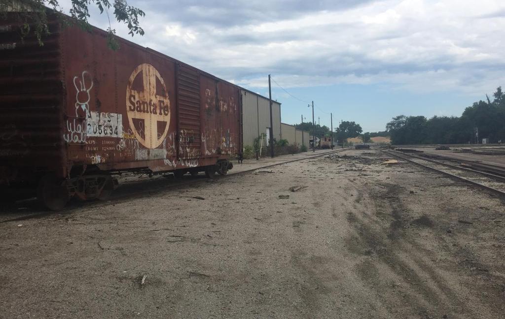
7 Alignment: E2 (includes E2.a and E2.b)(Map Color: E2-Purple, E2.a-Light Purple, E2.b-Lilac) Description: This alignment connects to the north end of the D1 and D2 alignment and splits into two alignment options, E2.a and E2.b. E2.a continues northwest along the southwest side of the Railroad until it reaches the southeast edge of the Depot property. E2.b heads west along the north side of 8 th Street and continues north along the east side of New Jersey Street until it reaches the Depot property. Alignment E2.a and E2.b merge into Alignment E2 at the Depot and continues along the north side of New Jersey Street and 7 th Street until it reaches New York Street. Strengths: - Route E2.a does not cross any driveways and is isolated from vehicle traffic until it reaches the Depot property. - Routes E2.b and E2 are generally familiar routes for existing Loop users connecting between existing sections. Weaknesses: - Alignment E2.b crosses the driveways of several businesses along the route. Opportunities: - This route provides a direct connection to the Amtrak Depot. - Route E2.b is on a route that is located within street right-of-way but does not have any existing sidewalk. This alignment would fill that gap. - Plans for the Depot include a 10 path with the proposed improvements. Threats: - Route E2.a is aligned on Railroad property. An agreement with the Railroad would be necessary to allow this route to be constructed as shown. Section Statistics: - Approximate Length 1,300 ft. (E2, E2.a), 1,560 (E2, E2.b) - Residential Driveway Crossings 0 - Commercial Driveway Crossings 2 (E2, E2.a), 7 (E2, E2.b) - At-Grade Street Crossings 1 - Pedestrian/Bicycle Crashes ( ) N/A - Adjacent Roadway Speed Limit 30 mph (E 8 th St., New Jersey St.) - Adjacent Roadway Average Annual Daily Traffic 2013: 1,430 (E 8 th St.), 2014: 1,824 (W 8 th St./Delaware St.) Page 7 of 12

 Page 8 of")
8 Alignment: E2 (includes E2.a and E2.b) Page 8 of 12
9 Alignment: F1 (Map Color: Light Green) Description: This alignment connects to the north end of the E1 and E2 alignments and continues along the east and north sides of the Riverfront Mall parking area. The route continues onto the Riverfront Mall Promenade area until it reaches the west end of the building. The proposed route would cut through the existing building and then continue west along the north side of the Railroad until it reaches the existing path. Strengths: - This route does not cross any driveways and is isolated from vehicle traffic and at-grade street crossings. - This is a very scenic route as it is adjacent to the Kansas River. Weaknesses: - The section of the route adjacent to the Railroad may feel confined due to the buildings on one side and the Railroad on the other. - The section of the route adjacent to the Railroad would occupy a space that is currently used for deliveries to the adjacent building. - Improvements would be necessary on the Promenade to correct drainage issues and eliminate standing water. - There is not a dedicated pedestrian/bicycle crossing at New York Street but there is a signalized railroad crossing (connection to F1 from E2 only). Opportunities: - The pass thru in the existing building would create a unique feature on the Lawrence Loop. Other amenities could be considered in this pass thru to provide services. Threats: - A portion of this route is aligned on Railroad property. An agreement with the Railroad would be necessary to allow this route to be constructed as shown. - A portion of this route is located on the Promenade of the Riverfront Mall. The Promenade is closed from January 1 to March 1 by Order of the Corps of Engineers. This restriction would need to be removed for a year round connection. - The owners of the Riverfront Mall would need to agree to allow the construction of the pass thru in the building and the use of the Promenade. Section Statistics: - Approximate Length 2,680 ft. - Residential Driveway Crossings 0 - Commercial Driveway Crossings 1 (adjacent to Commercial Driveway) - At-Grade Street Crossings 0 - Pedestrian/Bicycle Crashes ( ) N/A - Adjacent Roadway Speed Limit N/A - Adjacent Roadway Average Annual Daily Traffic 2013: 220 (New York St./Railroad) Page 9 of 12
10 Alignment: F1 Page 10 of 12
11 Alignment: F2 (includes F2.a and F2.b)(Map Color: F2-Green, F2.a-Neon Green, F2.b-Mint Green) Description: This alignment connects to the north end of the E1 and E2 alignments and splits into two alignment options, F2.a and F2.b. Route F2.a heads north along the east side of New York Street until it reaches the south side of the Railroad. The route continues west along the south side of the Railroad and Parking Garage until it reaches Rhode Island Street. Route F2.b heads west along the north side of 7 th Street and continues north along the west side of Rhode Island Street until it reaches the Parking Garage. Alignments F2.a and F2.b merge into Alignment F2 at the Parking Garage and then continues north and west along the west and south edges of the Parking Garage to New Hampshire Street. The route continues on the north side of 6 th Street to the access road and then continues heading north and crossing the Railroad and connects to the existing path. Strengths: - Route F2.b and F2 are generally within or adjacent to existing right-of-way. - Routes F2.b and F2 are generally familiar routes for existing Loop users connecting between existing sections. Weaknesses: - Route F2.b crosses an alley between Rhode Island Street and Connecticut Street that has poor visibility and crosses multiple streets with at-grade crossings. - Route F2.b construction will require the removal of landscaping and trees along 7 th Street. - Route F2 crosses Massachusetts Street and Vermont Street with signalized at-grade crossings. - Route F2 crosses the Railroad with an unsignalized at-grade crossing. - Route F2.a crosses terrain that would make the path difficult to construct and meet ADA requirements. Less experienced users may find the route difficult to navigate. Opportunities: - Route F2 could be expanded in the future to create an underpass on the south side of the Railroad under the existing Kaw Bridges which could be tied to Robinson Park. This bypass would eliminate the at-grade crossings of Massachusetts Street and Vermont Street. Threats: - A portion of Route F2.a is aligned on Railroad property. An agreement with the Railroad would be necessary to allow this route to be constructed as shown. - This route crosses several areas of private property and easement acquisition would be necessary. Section Statistics: - Approximate Length 3,110 ft. (F2, F2.a), 3,050 ft. (F2, F2.b) - Residential Driveway Crossings 0 - Commercial Driveway Crossings 2 (F2, F2.a), 6 (F2, F2.b) - At-Grade Street Crossings 5 (F2, F2.a), 4 (F2, F2.b) - Pedestrian/Bicycle Crashes ( ) 2016 (Collision w/pedestrian at 6 th /Vermont) - Adjacent Roadway Speed Limit 30 mph (New York St., Rhode Island St., E 7 th St., E 6 th St.) - Adjacent Roadway Average Annual Daily Traffic N/A Page 11 of 12

 Page 12")
12 Alignment: F2 (includes F2.a and F2.b) Page 12 of 12
Auburn Trail / Ontario Pathways Trail Connector Feasibility Study Public Information Meeting Wednesday, August 22, 2012
 Auburn Trail / Ontario Pathways Trail Connector Feasibility Study Public Information Meeting Wednesday, August 22, 2012 Purpose of Feasibility Study Purpose Evaluate the feasibility of constructing a multiuse
FEASIBILITY CRITERIA
 This chapter describes the methodology and criteria used to evaluate the feasibility of developing trails throughout the study areas. Land availability, habitat sensitivity, roadway crossings and on-street
United States Department of the Interior National Park Service. Boundary Expansion Listed in National Register January 11, 2017
 NPS Form 10900-a (Rev. 8/2002) OMB No. 10240018 United States Department of the Interior National Park Service Boundary Expansion Listed in National Register January 11, 2017 National Register of Historic
Stephens State Park Trails
 TRAILS OF ALLAMUCHY MOUNTAIN & STEPHENS STATE PARKS Allamuchy Mountain and Stephens State Parks contain 28 marked trails providing access to diverse landscapes for walking, hiking, biking, bird-watching,
OR MISSION TRAIL ELEMENTARY
 Leawood: overview OVERLAD PARK 24: p.70 I-LA PARK 32: p.72 TOMAHAWK PARK 23: p.69 31: p.71 GEZER PARK OR MISSIO TRAIL ELEMETARY 22: p.68 W 133rd St W 135th St KASAS CITY MO - other segments Beginning/end
2. Goals and Policies. The following are the adopted Parks and Trails Goals for Stillwater Township:
 D. PARKS AND TRAILS 1. Introduction Stillwater Township s population is relatively low, with most residents living on rural residences on large lots. The need for active park space has been minimal in
TRAFALGAR PARK. 78: p.140 W 99th St FLAT ROCK CREEK PARK. W 103rd St OVERLAND PARK. Quivira Rd. College Blvd. Shared use path. Mountain bike trail
 Lenexa: overview TRAFALGAR PARK 78: p.140 As the Westport Route crosses over Lenexa's boundaries with Olathe and Overland Park several times, approximately 2.75 or 3 miles of the historic route of the
Lake Erie Commerce Center Traffic Analysis
 LOCATION: East of NYS Route 5 at Bayview Road Town of Hamburg Erie County, New York PREPARED BY: Wendel Companies 140 John James Audubon Parkway Suite 200 Amherst, New York 14228 January 2012 i ii Table
THREE MILE PLAN TOWN OF SUPERIOR COLORADO
 THREE MILE PLAN TOWN OF SUPERIOR COLORADO February 23, 2015 INTRODUCTION This document has been prepared by the Town of Superior, Colorado, to address the existing and proposed land uses within an approximate
3. COLTA / HUGA CONNECTIONS - PRELIMINARY
 9 3. COLTA / HUGA CONNECTIONS - PRELIMINARY 3.1 COLTA The Chain of Lakes Trail Association (COLTA) trail, formerly identified as the Chester Spur Line, was completed and opened for use in June 2011. The
FINAL. Bicycle/Pedestrian Feasibility Study City of DeBary Dirksen Drive Trail. Prepared For: Volusia County MPO
 City of DeBary Dirksen Drive Trail FINAL Prepared By: Reynolds, Smith and Hills, Inc. Prepared For: Volusia County MPO September 2007 Table of Contents INTRODUCTION...1 PROJECT PURPOSE AND SCOPE...2 PHYSICAL
Construction underway. STATUS: 229 5,190 5,419 5,305 STIP REFERENCE #FR /01/2013
 FREDERICK COUNTY STATE HIGHWAY ADMINISTRATION -- Frederick County -- Line 1 PROJECT: I-7, Baltimore National Pike INTERSTATE CONSTRUCTION PROGRAM DESCRIPTION: Widen I-7 east of MD 355 to east of MD 144
Chapter 4.0 Alternatives Analysis
 Chapter 4.0 Alternatives Analysis Chapter 1 accumulated the baseline of existing airport data, Chapter 2 presented the outlook for the future in terms of operational activity, Chapter 3 defined the facilities
Grove Field Airport Environmental Assessment
 Grove Field Airport Environmental Assessment Advisory Committee Meeting #2 December 9, 2008 Port of Camas-Washougal Conference Room 6:00 7:30 PM Agenda: Welcome and Overview Dave Ripp, Director, Port of
EXECUTIVE SUMMARY FALL Introduction. Findings
 EXECUTIVE SUMMARY FALL 2004 Introduction Trails are one of the most popular and highly desirable recreational resources in communities of all sizes throughout the country. In addition to providing a safe
PURPOSE AND NEED (CONCURRENCE POINT 1) NEW CANADA ROAD PROJECT FROM STATE ROUTE 1 (U.S. HIGHWAY 70) TO U.S. INTERSTATE 40
 NEW CANADA ROAD PROJECT FROM STATE ROUTE 1 (U.S. HIGHWAY 70) TO U.S. INTERSTATE 40") PURPOSE AND NEED (CONCURRENCE POINT 1) NEW CANADA ROAD PROJECT FROM STATE ROUTE 1 (U.S. HIGHWAY 70) TO U.S. INTERSTATE 40 Project Description The primary purpose of this project is to improve the major
PURPOSE AND NEED (CONCURRENCE POINT 1) NEW CANADA ROAD PROJECT FROM STATE ROUTE 1 (U.S. HIGHWAY 70) TO U.S. INTERSTATE 40 Project Description The primary purpose of this project is to improve the major
BRACEVILLE NATURE PRESERVE Introductions History Present Conditions Future Development Plans Implementation Strategies Statistics
 BRACEVILLE NATURE PRESERVE Introductions History Present Conditions Future Development Plans Implementation Strategies Statistics Introduction Braceville Nature Preserve is one of MetroParks largest preserves.
4. Safety Concerns Potential Short and Medium-Term Improvements
 NH Route 104 Access Management Study Page 19 4. Safety Concerns Potential Short and Medium-Term Improvements Potential safety improvement strategies are listed by priority based on field observations by
City of Haslett. City of East Lansing. City of East Lansing
 Central Park North (Nancy L. Moore Park) Lake Park North Expansion White Park Expansion #2 White Park Expansion #1 County East East Haslett East East TF87-212 Acquisition $90,000.00 Park. TF08-138 Acquisition
ONONDAGA CREEKWALK PHASE II. Public Information Meeting Series 1
 ONONDAGA CREEKWALK PHASE II Public Information Meeting Series 1 Andrew Maxwell Director, Syracuse-Onondaga County Planning Agency Owen Kerney Assistant Director for City Planning Russell Houck, PE City
Trail Phasing Plan. Note: Trails in the Clear Creek Canyon area (Segments will be finalized in the future to minimize wildlife impacts
 Note: Trails in the Clear Creek Canyon area (Segments 2 5 and a future JCOS connection) will be finalized in the future to minimize wildlife impacts Trail Phasing Plan P Parking 3 Easy Trail Intermediate
STRENGHTS TEXAS TECH UNIVERSITY
 STRENGHTS TEXAS TECH UNIVERSITY The university is a vital component to the Lubbock economy. Every year, Texas Tech brings in millions of dollars from sporting events, students, and support. The total campus
Route 141 and I-44 Design-Build Project Community Involvement Group. March 21, 2016
 Route 141 and I-44 Design-Build Project Community Involvement Group March 21, 2016 Purpose of CIG 1. Share information with major stakeholders 2. Keep stakeholders informed of the process 3. Reduce uncertainty
EAST DON TRAIL ENVIRONMENTAL ASSESSMENT. Community Liaison Committee Meeting #3 July 15, :30 to 8:30 pm Flemingdon Park Library
 EAST DON TRAIL ENVIRONMENTAL ASSESSMENT Community Liaison Committee Meeting #3 July 15, 2013 6:30 to 8:30 pm Flemingdon Park Library Agenda 1. Welcome 2. Housekeeping and Updates a) Housekeeping b) CLC
Appendix L Technical Memorandum Aesthetics
 Technical Memorandum Aesthetics 1.0 AESTHETICS This section provides a discussion of the aesthetic resources in the vicinity of ARTIC. Aesthetics pertain to the elements that make a certain view pleasing
Stage 2 - November 2017 Survey and Map Comments (verbatim)
") Stage 2 - November 2017 Survey and Map Comments (verbatim) Identifying information removed to meet Freedom of Information and Protection of Privacy Act (FOIP Act). Comments are recorded exactly as they
Stage 2 - November 2017 Survey and Map Comments (verbatim) Identifying information removed to meet Freedom of Information and Protection of Privacy Act (FOIP Act). Comments are recorded exactly as they
Gardner: overview. Santa Fe, Oregon, and California National Historic Trails UNINCORPORATED JOHNSON COUNTY OLATHE UNINCORPORATED JOHNSON COUNTY
 Santa Fe, Oregon, and California ational Historic Trails : overview 99: p.134 100: p.135 GARDER JUCTIO 102: p.137 56: p.126 EDGERTO Burlington orthern Intermodal and Logistics 98: p.133 101: p.136 S Waverly
Environmental Assessment and Final Section 4(f)
") Environmental Assessment and Final Section 4(f) South Pleasant View Road, City of Madison County Highway M Reconstruction Cross Country Road to Prairie Hill Road Project ID 5992-09-81 September 16, 2016
Environmental Assessment and Final Section 4(f) South Pleasant View Road, City of Madison County Highway M Reconstruction Cross Country Road to Prairie Hill Road Project ID 5992-09-81 September 16, 2016
Longmont to Boulder Regional Trail Jay Road Connection DRAFT FINAL REPORT
 Longmont to Boulder Regional Trail Jay Road Connection DRAFT FINAL REPORT December 2018 Project Summary Boulder County, Colorado, in partnership with the City of Boulder, is evaluating options for multi-use
Trails Technical Committee
 Trails Technical Committee Winter 2017 Draft Report Alignment Proposals for the Inyo National Forest and the Town of Mammoth Lakes Map ID #S18 February 08, 2017 Map ID #S18 Key Agreements As of February
MORGAN CREEK GREENWAY Final Report APPENDICES
 APPENDICES MORGAN CREEK GREENWAY Appendix A Photos of Existing Conditions in Trail Corridor Photos of existing conditions Main trail corridor - February 2009 Photos of existing conditions south bank Morgan
CITY COUNCIL AGENDA MEMORANDUM
 To: Mayor and City Council From: Charles Ozaki, City and County Manager Prepared By: Kevin Standbridge, Deputy City and County Manager Katie Allen, City and County Engineer David Shinneman, Community Development
Public Information Center August 12, 2010
 Route 52 Causeway Bridge Replacement & Somers Point Circle Elimination Project Somers Point Atlantic County Public Information Center August 12, 2010 Ocean City Cape May County Presentation Overview General
Route #1) Mt. of the Holy Cross - North Ridge
 Mt. of the Holy Cross - North Ridge") Climbing 14ers can be very dangerous, please read the Mountaineering Safety Page and make sure you have a map+compass and can use them effectively, without the help of electronic devices. Route #1) Mt.
Climbing 14ers can be very dangerous, please read the Mountaineering Safety Page and make sure you have a map+compass and can use them effectively, without the help of electronic devices. Route #1) Mt.
Route 29 Solutions Projects
 Your guide to the Route 29 Solutions Projects For full details & continued engagement please visit www.route29solutions.org The Route 29 Solutions Package is a $230 million investment into the improvement
Bicycle Wayfinding Signage Study
 Bicycle Wayfinding Signage Study Fargo Moorhead Metropolitan Council of Governments January 2016 Version Introduction The purpose of the Bicycle Signage Study was to set forth a method of creating wayfinding
2008 DEKALB COUNTY TRANSPORTATION PLAN (UPDATE)
") 2008 DEKALB COUNTY TRANSPORTATION PLAN (UPDATE) TABLE OF CONTENTS Introduction 1 Transportation Planning Activities 2 Identification of Problem Areas and Recommended Solutions 7 DeKalb County Projects
2008 DEKALB COUNTY TRANSPORTATION PLAN (UPDATE) TABLE OF CONTENTS Introduction 1 Transportation Planning Activities 2 Identification of Problem Areas and Recommended Solutions 7 DeKalb County Projects
Welcome to the Illinois High-Speed Rail Chicago to St. Louis Construction Update Meeting. Today s meeting will provide an overview of the Program,
 Welcome to the Illinois High-Speed Rail Chicago to St. Louis Construction Update Meeting. Today s meeting will provide an overview of the Program, updates on construction to be held in this area, and how
UMASS CROSS-COUNTRY Trails
 UMASS CROSS-COUNTRY Trails 1) EGG (43 min) (A) From Cage proceed to North Pleasant street (by campus pond). Make left and head toward LGRT and pass School of Education. Pass Puffton Apt complex (on left)
Trail Feasibility Study
 VOLUSIA COUNTY MPO CITY OF NEW SMYRNA BEACH FINAL REPORT JUNE 30, 2009 Trail Feasibility Study What s inside? 1 Introduction 2 Project Purpose & Scope 3 Physical Inventory & Assessment of Right-of- Way
Site Location and Setting
 Memorandum Date: To: From: Subject: Kristy Le, Gary Black Steve Orem Santa Teresa County Park Historic Area Traffic and Parking Study Hexagon Transportation Consultants, Inc. has completed a traffic and
Memorandum. To: From: cc: Date: November 7, Re: 1.0 Purpose and Organization of this Addendum. 2.0 Project Description
 Memorandum To: From: cc: Laura Prickett, Horizon Water and Environment Analette Ochoa and Wana Chiu, WRECO Parag Mehta, Kimley Horn Date: November 7, 2017 Re: Santa Cruz Route 1 Tier I and Tier II HOV
Dungeness Recreation Area County Park Master Plan
 Dungeness Recreation Area County Park Public Outreach Meeting October 10, 2007 Project Overview USFWS Site Dungeness Recreation Area County Park Meeting Objectives: Re-Introduce project; provide status
Blueways: Rivers, lakes, or streams with public access for recreation that includes fishing, nature observation, and opportunities for boating.
 Parks, Open Space and Trails PRINCE WILLIAM COUNTY 2008 COMPREHENSIVE PLAN TRAILS PLAN CONTENTS The components of the trails plan are: Intent Definitions Goals, Policies, and Action Strategies Trails Map
Attachment D: PHOTO LOG CITY OF ARCATA RAIL-WITH-TRAIL CONNECTIVITY PROJECT
 01051-09004 Attachment D: PHOTO LOG CITY OF ARCATA RAIL-WITH-TRAIL CONNECTIVITY PROJECT DRAFT: June 30, 2010 Applicant: City of Arcata 736 F Street Arcata, CA 95521 Phone (707) 825-2154 Prepared by: Winzler
State Route 8 Corridor. Northern Summit County s Path to Success
 State Route 8 Corridor Northern Summit County s Path to Success Construction Guide: 2008-2009 State Route 8 corridor work description State Route 8 Corridor 10 projects $262 million With its close proximity
CONTACT: Nichole Lawrence CELL: FOR IMMEDIATE RELEASE Wednesday March 28, 2018
 FOR IMMEDIATE RELEASE Wednesday March 28, 2018 CONTACT: Nichole Lawrence CELL: 731-225-6041 West Tennessee Construction March 28-April 4, 2018 Per TDOT Specifications, there will be no temporary lane closures
At the time, the portion of the line through Eagle County remains wholly under the ownership of Union Pacific Railroad (UP).
.") Chapter 5 The Railroad Corridor as a Trail Corridor The intent of this chapter is to identify how the rail corridor, if available for lease or purchase in all or part, could be incorporated into the core
Chapter 5 The Railroad Corridor as a Trail Corridor The intent of this chapter is to identify how the rail corridor, if available for lease or purchase in all or part, could be incorporated into the core
Spencer Environmental Appendix A: Alternative Analysis for Construction Access Route
 Spencer Environmental Appendix A: Alternative Analysis for Construction Access Route February 2015 Valley ine-stage 1 RT EISA Update FINA REPORT Page A1 Memorandum AECOM ConnectEd Transit Partnership 10235
Header i
 Header i 048285014.10 Header Sub Title Body Text here. Body text here. Body text here. Section 1... 1 Executive Summary... 1 Opportunities and Constraints... 3 Overall Opportunities and Constraints Map
Northaven Trail Phase 2 Initial Project Overview
 Northaven Trail Phase 2 Initial Project Overview Partnership Project to extend existing Northaven Trail Improve Bike/Ped Connectivity On Dallas Trail Network Plan City and County Funding Oncor Texas Trails
New Jersey Department of Transportation
 Administration, Organization, Records Management & Information Requests 16:1A-4.4(a) Copying fees - Records Page 1 10: $0.75 per page Page 11 20: $0.50 per page Over 20 pages - $0.25 per page 16:1A-4.5(c)
Attachment No. 20 RRLRT No. 1. Committee. Busway Grade Crossings STATUS/DATE OF ACTION
 Attachment No. 20 RRLRT No. 1 TECHNICAL COMMITTEE: Railroad / Light Rail Transit Technical Committee TOPIC: Busway Grade Crossings STATUS/DATE OF ACTION RRLRT TC Draft: 06/23/2011 RRLRT TC Approval: 06/27/2014
A number of goals were identified during the initial work on this Big Lake Transportation Plan.
 C. Transportation General Background Information Big Lake s transportation system includes all the roads, paths and facilities that allow the movement of private vehicles, trains and planes, as well as
THE STATE OF GRAYSLAKE
 THE STATE OF GRAYSLAKE Presented by: Mayor Rhett Taylor January 23, 2014 The State of Grayslake Economic Development Transportation Village Center Plans Economic Development Cost Savings Programs: Village
Segment 2: La Crescent to Miller s Corner
 goal of the USFWS refuges is to conserve, protect and enhance fish, wildlife and plants and their habitats for the continuing benefit of the American people. Refuge lands are used largely for fishing,
APPALACHIAN TRAIL THROUGH GEORGIA. Long Distance YRE 2018/Y2289, rated 4D. Table of Contents. HOW TO HIKE THE AT IN GEORGIA THE BASICS Page 2
 Table of Contents HOW TO HIKE THE AT IN GEORGIA THE BASICS Page 2 THE SUGGESTED 8 DAY HIKES PLUS APPROACH Page 3 OPTIONAL A AWARD Page 4 HIKING GUIDELINES Page 4 AFTER YOU HAVE COMPLETED THE HIKE Page
APPENDIX F List of Commitments
 APPENDIX F List of Commitments s Table F.1 Standard Mitigation Measures Mitigation Measure MnDOT Specification Number Status Update Description Status Update Utilities Provide early notice to utility operators
Blue River Trail Master Plan JSA to Town Hall June 2004
 Blue River Trail Master Plan JSA to Town Hall June 2004 Prepared for: Silverthorne Town Council Silverthorne SPORT Committee Department of Recreation and Culture Silverthorne Public Works Silverthorne
PIONEER PARK. City of Des Peres Parks Master Plan. SWT Design 46 INTRODUCTION
 PIONEER PARK INTRODUCTION Pioneer Park is a 7 acre neighborhood park located east of Interstate 270 and south of Manchester Road along Tallie Road. The park is situated in a residential neighborhood with
Meshach Browning Trail System at the Deep Creek Lake Lion s Club Park on Bumble Bee Rd.
 Meshach Browning Trail System at the Deep Creek Lake Lion s Club Park on Bumble Bee Rd. The Meshach Browning trail system will be a public, non-motorized, multi-use (running, dog-walking, cross country
Public Notice ISSUED: December 10, 2018 EXPIRES: January 9, 2019
 APPLICANT: REFER TO: St. Louis and Lake Counties Regional Rail Authority 2018-01942-ARC Public Notice ISSUED: December 10, 2018 EXPIRES: January 9, 2019 SECTION:404 - Clean Water Act 1. APPLICATION FOR
Frequently Asked Questions on the Route 29 Solutions Improvements Projects
 Frequently Asked Questions on the Route 29 Solutions Improvements Projects Background What are the Route 29 Solutions improvement projects? These projects include the Route 29/250 Interchange ( Best Buy
SCOPING INFORMATION PACKET
 SCOPING INFORMATION PACKET Project Description The proposed project would provide a direct link connecting several light rail lines in operation or in construction, including the Metro Gold Line to Pasadena,
Trail Beginning Elevation: 7553 ft The Poison Creek Trailhead is located at the end of National Forest Road 646E (NF-646E).
.") West Mountain Trails Poison Creek Trail #134 Length: 2.9 miles (4.7 km) Difficulty Horseback: A good trail for the first time west mountain rider, some steep sections Hiking: Most Difficult USGS Maps:
West Mountain Trails Poison Creek Trail #134 Length: 2.9 miles (4.7 km) Difficulty Horseback: A good trail for the first time west mountain rider, some steep sections Hiking: Most Difficult USGS Maps:
Construction Update. Local Officials Briefing March 2016
 Construction Update Local Officials Briefing March 2016 1 History: Chicago-St. Louis Corridor Since 1980 s IDOT has been looking at this corridor for high-speed service 1992 Designated a HSR Corridor EIS
Lake Wissota Access Locations within the LaFayette Township. By Chad Martin
 Lake Wissota Access Locations within the LaFayette Township By Chad Martin Anson/ Wissota Access Point # 1 Road: 195 th St. Associated Fire Numbers: 13294 Defining Characteristics: Forested from road
November 21, 2012 Barbara Kelleher, (954)
") November 21, 2012 Barbara Kelleher, (954) 777-4090 barbara.kelleher@dot.state.fl.us BROWARD COUNTY TRAFFIC IMPACT REPORT November 26 to November 30, 2012 FORT LAUDERDALE -- Construction and maintenance-related
November 21, 2012 Barbara Kelleher, (954) 777-4090 barbara.kelleher@dot.state.fl.us BROWARD COUNTY TRAFFIC IMPACT REPORT November 26 to November 30, 2012 FORT LAUDERDALE -- Construction and maintenance-related
Thornton Water Project. Larimer County Route Study and Project Update September 12, 2017
 Thornton Water Project Larimer County Route Study and Project Update September 12, 2017 Purpose of Meeting Provide information on the Thornton Water Project Present the results of the pipeline routing
Georgetown-Lewes Rail/Trail Study. Rail/Trail Study: Cool Spring to Cape Henlopen State Park New Road Extension (House Resolution No.
 Georgetown-Lewes Rail/Trail Study Rail/Trail Study: Cool Spring to Cape Henlopen State Park New Road Extension (House Resolution No. 47) August 22, 2011 Presentation Outline Background Benefits Statewide
Rails with Trails Finding the mobility, safety, and liability sweet spot 5/10/2017
 Rails with Trails Finding the mobility, safety, and liability sweet spot 5/10/2017 The National Transportation Systems Center Advancing transportation innovation for the public good U.S. Department of
Appendix 4.1 L. No-Build Project Descriptions
 Appendix 4.1 L No-Build Project Descriptions No-Build Projects New Bedford A new traffic signal system was installed and activated in early 2009 at the intersection of King s Highway and Mount Pleasant
Understanding the caring capacity of the visitor experience Provide facilities to support a high level user experience Address visual quality through
 Understanding the caring capacity of the visitor experience Provide facilities to support a high level user experience Address visual quality through recreation ecological restoration opportunities Collaboration
Need County Priority Needs Identification Major Projects/Emerging Taking Care of the System (TCOS) 1=High 2=Medium 3=Low
 1=High 2=Medium 3=Low") PIONEER TRAILS REGIONAL PLANNING COMMISSION TRANSPORTATION NEEDS -- 2015 TRANSPORTATION PLANNING GOALS BY MODOT CATEGORIES Pioneer Trails transportation needs are listed according to MoDOT s two major
PIONEER TRAILS REGIONAL PLANNING COMMISSION TRANSPORTATION NEEDS -- 2015 TRANSPORTATION PLANNING GOALS BY MODOT CATEGORIES Pioneer Trails transportation needs are listed according to MoDOT s two major
RIVER ACCESS STRATEGY
 RIVER ACCESS STRATEGY The River Access Strategy is a 10-year plan the City of Edmonton is developing to inform future programming, operations and infrastructure improvements that support access to the
Airport Planning Area
 PLANNING AREA POLICIES l AIRPORT Airport Planning Area LOCATION AND CONTEXT The Airport Planning Area ( Airport area ) is a key part of Boise s economy and transportation network; it features a multi-purpose
3.0 EXISTING PARK & RECREATION SPACE
 3.0 EXISTING PARK & RECREATION SPACE TOWN PARK & RECREATION SPACE An inventory of current parks and recreation area in the Town of Cedarburg is shown in Table 3. These areas total roughly 381.89 acres.
SOUTH INTERCHANGE AREA
 Santaquin City General Plan 1 Location and Characteristics The South Interchange Area of Santaquin is located west of Interstate 15 and south of 500 South (Figure 1). It includes properties already annexed
Railroad Safety Trail
 2.1 INTRODUCTION AND PROJECT SETTING 2.1 Introduction & Project Setting Introduction This study is the result of a directed effort on the part of the City of San Luis Obispo to carry out previously established
WEEKLY PROVINCIAL HIGHWAY CONSTRUCTION UPDATE FOR THURSDAY, OCTOBER 6, 2016 The law is black and white. Slow to 60 km/hr in Work Zones.
 NEW WORK PROJECT/WORK: Highway 354 near Dilke ESTIMATED COST: $3.4M START OF THIS YEAR'S CONSTRUCTION: October 1, 2016 DESCRIPTION: About 17 km of surfacing on Highway 354 from the junction with Highway
Curriculum Pacing Guide Grade/Course 5 Th Grade Geography Grading Period 1 st Nine Weeks
 2013-2014 Curriculum Pacing Guide Grade/Course 5 Th Grade Grading Period 1 st Nine Weeks Time Frame Unit/ photographs, pictures, and tables to Locate and identify: Continents and Oceans -North America
FDOT Treasure Coast Traffic Impact Report October 9 through October 16, 2015
 From: Kathleen Dempsey To: Kathleen Dempsey Subject: FDOT Treasure Coast Traffic Report 10 09 15 through 10 16 15 Date: Friday, October 09, 2015 2:10:36 PM Attachments: image003.png CR 714_Median Construction
Second Avenue: Union Street to Lenora Street, Condominium Owners c/o Michael McQuaid 1521 Second Avenue Seattle, WA 98101
 Second Avenue: Union Street to Lenora Street, Condominium Owners c/o Michael McQuaid 1521 Second Avenue Seattle, WA 98101 Subject: New Development - Cumulative Downtown Alley Traffic Congestion and Safety
Whittier Bridge Project
 Amesbury / Newburyport / Salisbury Whittier Bridge / I-95 Improvement Project Original Whittier Bridge Proposed Whittier Bridges 10/21/2016 Whittier Bridge Project 1 Project Description The project limits
Becker County Trail Routing Feasibility Study
 2016 Becker County Trail Routing Feasibility Study CONNECTING DETROIT MOUNTAIN AND MOUNTAIN VIEW RECREATIONAL AREA TO THE HEARTLAND TRAIL BECKER COUNTY ULTEIG ENGINEERS Contents Acknowledgements...2 INTRODUCTION...3
FIRE Equipment Fire Training Equipment 105, , Total of Equipment 105, ,
 FIRE Equipment Fire Training Equipment 105,000-105,000 - - - - - - - - - - Total of Equipment 105,000-105,000 - - - - - - - - - - Fire Apparatus Aerial Ladder Replacement 5,320,000 1,120,000 - - 1,400,000
Business Item No XXX. Proposed Action That the Metropolitan Council approve the Coon Creek Regional Trail Master Plan.
 Business Item No. 2015-XXX Metropolitan Parks and Open Space Commission Meeting date: July 7, 2015 For the Community Development Committee meeting of July 20, 2015 For the Metropolitan Council meeting
Additional Economic Development Strategy submissions- Klickitat County
 Klickitat County Transportation Improvement Projects 1 White Salmon to Hood River Bridge Final EIS, design, bridge replacement 2 Klickitat County Rural Arterials Reconstruct to all-weather roads Part of
Community Development Committee
 C Community Development Committee For the Metropolitan Council meeting of October 31, 2012 Committee Report Item:2012-316 ADVISORY INFORMATION October 16, 2012 Date Prepared: Subject: Intercity Regional
City of Durango 5.8 FUNDING TRAILS DEVELOPMENT
 5.8 FUNDING TRAILS DEVELOPMENT The City has been successful in establishing dedicated local funding sources as well as applying for grants to develop the City s trail system, having received nearly $2.4
SWINGING OVER SCHUYLKILL THE HISTORY OF THE PW&B AND BRIDGE NO. 31
 THE SWINGING OVER SCHUYLKILL THE HISTORY OF THE PW&B AND BRIDGE NO. 31 The Philadelphia, Wilmington & Baltimore Railroad Company (PW&B) was formed in 1836. In 1838, the railroad was enlarged by the joining
Alternatives Analysis City of Newport Beach Sunset Ridge Park Project December 14, 2011
 Alternatives Analysis City of Newport Beach Sunset Ridge Park Project December 14, 2011 Alternatives Analysis for Vehicular Access: This report supplements the project s certified EIR s Alternatives Analysis.
ORDINANCE NO. 510 THEREFORE, BE IT ORDAINED BY THE GOVERNING BODY OF THE CITY OF BEL AIRE, KANSAS:
 (Published in The Ark Valley News on July, 2012.) ORDINANCE NO. 510 S-I-1 GILMORE & BELL, P.C. 07/11/2012 AN ORDINANCE CREATING A COMMUNITY IMPROVEMENT DISTRICT IN THE CITY OF BEL AIRE, KANSAS; AUTHORIZING
Appendix 6 Fulbourn Greenway Review
 Appendix 6 Fulbourn Greenway Review Nigel Brigham & Associates A report for 1 Introduction This report is based on fieldwork carried out in 2016 to review the Greenway network around Cambridge as shown
NORTHWEST SECTION CONTENTS: CLEVELAND PARK FOLWELL PARK RYAN LAKE PARK VICTORY PRAIRIE DOG PARK VICTORY PARK
 NORTHWEST SECTION CONTENTS: CLEVELAND PARK FOLWELL PARK RYAN LAKE PARK VICTORY PRAIRIE DOG PARK VICTORY PARK LUCY LANEY COMMUNITY SCHOOL N 33RD AVE N 33RD AVE SINGLE-FAMILY RESIDENTIAL MULTI-USE DIAMOND
Northwest Triangle. Redevelopment Proposal. Property Acquisition, Engineering, and Demolition. December, 2005 REDEVELOPMENT AUTHORITY OF THE
 Northwest Triangle Redevelopment Proposal Property Acquisition, Engineering, and Demolition December, 2005 REDEVELOPMENT AUTHORITY OF THE CITY OF YORK York City Redevelopment Authority 14 West Market Street,
Corabelle Park. Inventory. Future Development
 Corabelle Park Size: Approximately 4 acres Site Description: Corabelle Park is a relatively new park within the Murray County Park System. It is located on the south side of Corabelle Lake just off gravel
TABLE OF CONTENTS. Coral Springs Charter High School and Middle School Job No Page 2
 Job No. 15-019 Page 2 TABLE OF CONTENTS 1.0 INTRODUCTION... 4 2.0 EXISTING CONDITIONS... 5 3.0 TRAFFIC GENERATION... 7 4.0 TRIP DISTRIBUTION... 8 5.0 FUTURE CONDITIONS... 8 6.0 SITE ACCESS...13 7.0 CONCLUSION...13
FORT WORTH DISTRICT. Springtown Area Projects. Loyl C. Bussell, P.E. Acting District Engineer. Thursday, February 8, 2018 Date.
 FORT WORTH DISTRICT Springtown Area Projects Loyl C. Bussell, P.E. Acting District Engineer Photo by Liam Frederick Footer Text Thursday, February 8, 2018 Date Maintaining a Safe System TxDOT is responsible
City of Solvang SUNNY FIELDS SPUR TRAIL STUDY
 City of Solvang SUNNY FIELDS SPUR TRAIL STUDY project description The City of Solvang, in partnership with the County of Santa Barbara Public Works Department, is developing an alignment study for a proposed