Appendix 4 St. Charles Basin
|
|
|
- Daisy Young
- 5 years ago
- Views:
Transcription
1 Appendix 4 St. Charles Basin The St. Charles hurricane protection system (HPS), shown in Figure 1, was designed as part of the Lake Pontchartrain, LA, and Vicinity Hurricane Protection Project. The St. Charles HPS protects 17.2 square miles of urban, industrial, commercial, and ecological lands that is essentially a low density residential community with a small business district along U.S. Highway 61. The St. Charles Basin is generally bounded on the north by the St. Charles HPS, on the south by the Mississippi River Levee (MRL) and on the west by the Bonnet Carre guide levee. As designed, the HPS levees were generally constructed with a 10-foot crown width with side slopes of 1V on 3H for both the flood side and protected side. Topography is flat with ground elevations ranging from +12 feet NGVD on the alluvial ridges along the Mississippi River to 2 feet NGVD near the locally maintained levee south of Lake Pontchartrain. Approximately 25 percent of the developed area is below sea level. The design elevation of the HPS levees varies from 13 feet on the west to 12 feet on the east. There are also floodwall segments along the line of protection that consists of sheet-pile walls or concrete capped sheetpile walls constructed on the top of the levee. The line of protection was designed to provide protection from the Standard Project Hurricane. As designed, there is a total of approximately 9.5 miles of earthen levees, 1 mile of floodwall, one pump station, and five drainage structures, three swing gate closures for road and rail crossings, and one open gap for a rail crossing. The MRL is generally designed to elevation 26 feet with a 10 foot crown and a 1 V on 3 H slope on the land side and a 1 V on 4 H on the flood side. Similarly, the Bonnet Carre guide levee is generally designed to elevation 20.3 feet with a 10 foot crown and a 1 V on 3 H slope on the land side and a 1 V on 4 H on the flood side. The basin is a mix of industrial and residential areas. The area between the HPS and Lake Pontchartrain is essentially a wetlands area. There are two sub-basins in the basin as shown in Figure 1. VIII-4-1

2 Figure 1. St. Charles Basin with sub-basins and annotations for significant features The St. Charles HPS is made up of Reach SC1 SC4 which begins at the Bonnet Carre Guide levee and extends eastward to the St. Charles Jefferson Parrish border. Reach SC1 is approximately 17,000-ft-long earthen levee (with a geotextile blanket) and contains (1) the Bayou Trepagnier Pump Station and Drainage Structure with a transition sheetpile wall, (2) a pipeline crossing and (3) the Good Hope floodwall. It was designed to a net grade of 13 ft MSL. VIII-4-2


3 Intersection of St. Charles HPS and the Bonnet Carre Guide Levee VIII-4-3


4 Trepagnier Drainage Structure Trepagnier Pump Station VIII-4-4

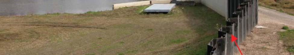
5 Pipeline Crossing with sheetpile transition to levee VIII-4-5

6 Industrial access road closure gate Reach SC2 is approximately 12,000-ft-long earthen levee (with a geotextile blanket) and contains (1) the Cross Bayou Drainage structure and the Gulf South Pipeline crossing. It is designed to an elevation of 12.5 ft. There is a 500-ft transition from 12.5 to 12 ft where SC3 begins. VIII-4-6


7 Cross Bayou Drainage Structure VIII-4-7
 the I310 Floodwall with one access gate, and (3) the railroad crossing near the airport runway extension.")
8 Gulf South Pipeline Crossing Reach SC3 is approximately 24,000-ft-long earthen levee (with a geotextile blanket) and contains (1) The St.Rose, Almedia, and Walker Drainage structures, (2) the I310 Floodwall with one access gate, and (3) the railroad crossing near the airport runway extension. The RR crossing closure gate was not in place during Hurricane Katrina, but has since been completed. It was closed by sandbags for Katrina. VIII-4-8


9 St. Rose Drainage Structure VIII-4-9

10 I-310 Floodwall VIII-4-10
 with 24-ft closure gate")
11 I-310 Floodwall access closure gate (normally closed) with 24-ft closure gate VIII-4-11


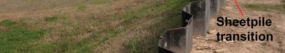
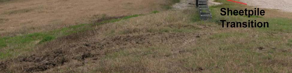
12 Alemedia Drainage Structure Walker Drainage Structure with sheetpile transition VIII-4-12
 constructed during")

13 Railway Gated Crossing at Airport Levee (not constructed during Katrina) Railway Gated Crossing at Airport Levee (not constructed during Katrina). HPS joins Airport Levee just north of the Railway Gated Crossing VIII-4-13

14 Reach SC4 is approximately 8,048-ft-long earthen levee with most of it having an embedded sheetpile wall in its crown. It is designed to an elevation of 27.9 ft. It extends from where the HPS intersects the airport runway extension levee to the St. Charles Jefferson Parish boundary, then proceeds southward to US 61, and on to the railroad crossing. Significant features are (1) an abrupt 3-ft drop in elevation at one 90 deg turn in the wall, (2) the 24-ft gap at the railroad crossing, (3) the US 61 crossing has no closure gate, and (4) the HPS ends at the railroad crossing, with the remainder of the Parrish boundary line at the same elevation as the RR until it intersects the MRL. The RR crossing gap was sandbagged during Katrina. Floodwall as it turns east by the Airport runway extension VIII-4-14
15 Corner of sheetpile floodwall as it turns south by the Airport runway extension (3 ft drop in elevation) VIII-4-15

16 Floodwall as it turns south just north of the railroad crossing VIII-4-16

17 Railroad crossing has no closure gate. During Katrina it was sandbagged. VIII-4-17
18 St. Charles Jefferson Parish Boundary Levee ends North of US 61 Highway gap at this crossing VIII-4-18

19 St. Charles Jefferson Parish Boundary Levee South of US 61 Highway no closure at this crossing VIII-4-19

20 Short Transition Section of HPS from South of US 61 toward railroad VIII-4-20

21 St. Charles Jefferson Levee at South side of US 61 VIII-4-21


22 The basin protection then continues westward as the MRL at a design elevation of 26 ft. The MRL is an earthen levee with a 10-ft crown. No major structure or pipeline passes through the MRL. VIII-4-22
23 Mississippi River Levee at the St. Charles-Jefferson boundary at Hwy 48 VIII-4-23

24 Top of Mississippi River Levee at the St. Charles-Jefferson boundary VIII-4-24
25 I-310 passing over the Mississippi River Levee At the east extend of the basin, the MRL intersects the Bonnet Carre guide levee, which continues the protection northward on the west side of the basin until it reached the HPS. This stretch contains the intersection with the spillway and US 61. VIII-4-25

26 Mississippi River Levee intersection with Bonnet Carre Guide Levee VIII-4-26

27 Bonnet Carre Spillway intersection with guide levee VIII-4-27

28 Bonnet Carre Guide Levee Looking North from the Spillway gates Risk Model Idealization The St. Charles Basin was descretized into two sub-basins (SC 1 and SC 2) as shown in Figure 1. The sub-basins were defined to correspond to the known interior drainage areas. This reach idealization follows from the basin description information presented above which was collected from project documents and field inspections. Figure 2 shows the elevations for the St. Charles HPS: PreKatrina- at the time of Katrina and Current-as of 1 June VIII-4-28
29 Figure 1. St. Charles Basin reach (SC01 SC06) and sub-basin (SC 2 and SC 2) definition for use in the risk model. Figure 2. Elevations for the St. Charles Basin for the Pre-Katrina HPS (in place when Katrina occurred) and the Current HPS (on 1 June 2007). VIII-4-29
Pump Stations...more than just pumps
 Task Force Hope Status Report Newsletter March 13, 2013 Pump Stations...more than just pumps Photo by Jerry Baggett Pump Station 11, Algiers Canal Repairs and Fronting Protection Repaired pump stations
Turning Water Into Land How New Orleans Created the Lakefront Neighborhoods,
 Cityscapes: A Geographer's View of the New Orleans Area Turning Water Into Land How New Orleans Created the Lakefront Neighborhoods, 1926-1934 Richard Campanella Published in the New Orleans Times-Picayune,
United States Department of the Interior National Park Service. Boundary Expansion Listed in National Register January 11, 2017
 NPS Form 10900-a (Rev. 8/2002) OMB No. 10240018 United States Department of the Interior National Park Service Boundary Expansion Listed in National Register January 11, 2017 National Register of Historic
Marilla Reservoir to Chestnut Ridge via Marilla Trails and Bullis Hollow Trail east to west
 USGS topographic maps useful to this hike are the Bradford and Stickney 7.5 minute sectionals. These notes are designed to assist in identifying distance and location using geophysical and man-made characteristics
WHY THERE IS NO STORM SURGE PROTECTION FOR THE LAKE PONTCHARTRAIN BASIN
 WHY THERE IS NO STORM SURGE PROTECTION FOR THE LAKE PONTCHARTRAIN BASIN A Report Addressing: I. The Reason Why The Corps Of Engineers Abandoned Its Plan To Keep Storm Surge Out Of The Lake Pontchartrain
Appendix E. System Issues
 Appendix E System Contents Page System... E-1 E.1 Introduction...E-1 E.2 Existing Model - System...E-2 E.2.1 Location: Country Ridge Collector, at Queensgate Drive...E-2 E.3 Committed Model - System...E-3
Speculative Investment in the Mississippi Delta of the Future
 Speculative Investment in the Mississippi Delta of the Future Introduction This report analyzes future scenarios of Southern Louisiana based on the events surrounding Hurricane Katrina and the possibility
Mississippi River & Tributaries Project History & Overview
 Mississippi River & Tributaries Project History & Overview Watershed Division Mississippi Valley Division 17 June 2015 US Army Corps of Engineers BUILDING STRONG Lake Texoma Spillway Tulsa Little Rock
4/28/17. Clicker Question. Clicker Question. #37 Floods IV (Case Histories-Mississippi River Flood, 1993; Red River of North Flood, 1997)
") GEOL 118 Final Exam Format similar to exams 1 and 2 Covers Lectures #27 40 (Global Climate Change I - Meteorite Impacts III) Web Exercise #6 - Due by 1 pm, Monday (5/1) 8:00 AM, Thursday, May 11 th Location
GEOL 118 Final Exam Format similar to exams 1 and 2 Covers Lectures #27 40 (Global Climate Change I - Meteorite Impacts III) Web Exercise #6 - Due by 1 pm, Monday (5/1) 8:00 AM, Thursday, May 11 th Location
2.0 Physical Characteristics
 _ 2.0 Physical Characteristics 2.1 Existing Land Use for the Project The site is comprised of approximately 114 acres bounded by Highway 101 to the north, the existing town of Los Alamos to the east, State
TRINITY RIVER CORRIDOR
 TRINITY RIVER CORRIDOR MODIFIED DALLAS FLOODWAY PROJECT UPDATE May 12, 2015 Jon Loxley Project Manager Dallas Floodway Project Fort Worth District U.S. Army Corps of Engineers US Army Corps of Engineers
MEMORANDUM FOR Commander. Lower Mississippi Valley Di visi':m. ATTN: CELMV-CO-O. SUBJECT: Project Operations - Inspection of Completed Works
 fwlr. Colletti/lpc/2244 CELHN-OD-:f.; OEC I 0 1991 MEMORANDUM FOR Commander. Lower Mississippi Valley Di visi':m. ATTN: CELMV-CO-O SUBJECT: Project Operations - Inspection of Completed Works 1. In accordance
DEPARTMENT OF PLANNING JEFFERSON PARISH, LOUISIANA
 DEPARTMENT OF PLANNING JEFFERSON PARISH, LOUISIANA DESIGN REVIEW REPORT : CPZ-3-5 ADVERTISING DATES: 03/25/5 04/0/5 04/08/5 : 2425 PUBLIC HEARING: 04/6/5 S: HEARING: 05/3/5 : Ricky J. Templet Chris Roberts,
Final Drainage Letter Pikes Peak Community College Downtown Parking Lot Colorado Springs, Colorado
 Final Drainage Letter Pikes Peak Community College Downtown Parking Lot Colorado Springs, Colorado Prepared for: Pikes Peak Community College 5775 South Academy Boulevard Colorado Springs, CO 80906-5422
FEASIBILITY CRITERIA
 This chapter describes the methodology and criteria used to evaluate the feasibility of developing trails throughout the study areas. Land availability, habitat sensitivity, roadway crossings and on-street
1. PROJECT BACKGROUND. June 25, Alberta Transportation Central Region #401, Street Red Deer, Alberta T4N 6K8
 Alberta Transportation Central Region #401, 4902 51 Street Red Deer, Alberta T4N 6K8 June 25, 2001 Mr. Melvin Mayfield, P.Eng. Construction Services Coordinator Dear Mr. Mayfield: Central Region Landslide
Northern Rail Extension, Phase One
 General Project and Funding 1. Where does Phase One start? The rail line for Phase One begins roughly at the northern boundary of the former Bradbury property, but also includes work along Tom Bear Trail
The following criteria shall be applied within the boundaries of the AO District:
 Sec. 419 (a) Purpose AIRPORT OVERLAY DISTRICT (AO) The purpose of the Airport Overlay District is to regulate and restrict the height of structures, objects, or natural growth, regulate the locations of
Overview of Highway 37 Project. Novato Rotary November 4, 2016
 Overview of Highway 37 Project Novato Rotary November 4, 2016 Project Location-Caltrans District 4 SR 37 Corridor Features Two to Four lane 21 mile corridor traversing Solano, Sonoma, and Marin Counties.
Stephens State Park Trails
 TRAILS OF ALLAMUCHY MOUNTAIN & STEPHENS STATE PARKS Allamuchy Mountain and Stephens State Parks contain 28 marked trails providing access to diverse landscapes for walking, hiking, biking, bird-watching,
80' MIN 100'-0" 15'-0" 2 FEDERALLY DREDGED NAVIGATION CHANNEL MEASURED AT EL -10' (NOTE 4) NAVIGATION CHANNEL EXISTING YACHT CLUB FLOATS
 NAVIGATION CHANNEL EXISTING YACHT CLUB FLOATS") 11 3 1 6 9 4 5 4 8 7 7 9 ' MUDLINE ELEVATION 8 1 6 11 6 1 7 8 5 7 7 12 11 5 12 7 8 9 5 11 8 REVISED FEDERAL LIMIT FOR DREDGING FEDERAL LIMIT FOR DREDGING 12 1 11 7 1 4 8 5 8 5 14 4 14 3 9 3 8 5 1 5 11
11 3 1 6 9 4 5 4 8 7 7 9 ' MUDLINE ELEVATION 8 1 6 11 6 1 7 8 5 7 7 12 11 5 12 7 8 9 5 11 8 REVISED FEDERAL LIMIT FOR DREDGING FEDERAL LIMIT FOR DREDGING 12 1 11 7 1 4 8 5 8 5 14 4 14 3 9 3 8 5 1 5 11
What do they mean to you?
 CANADA S NEW GRADE CROSSING REGULATIONS What do they mean to you? May 2, 2015 Floris van Weelderen, P.Eng., PTOE Becky Lai, EIT THE ACCIDENTAL GRADE CROSSING Gare Montparnasse, Paris October 22, 1895 2
Attachment G STREAM IMPACTS. Ridge Road Extension Alternatives Analysis
 Attachment G STREAM IMPACTS for: Ridge Road Extension Alternatives Analysis PREPARED FOR: Pasco County Engineering Services Department PREPARED BY: NV5, INC. 6989 E. FOWLER AVENUE TAMPA, FLORIDA 33617
The Mississippi River Commission. History of the Management of the Mississippi River. US Army Corps of Engineers BUILDING STRONG
 The Mississippi River Commission History of the Management of the Mississippi River US Army Corps of Engineers US Army Corps of Engineers Presentation Outline Overview of Mississippi River History of Mississippi
RAILS WITH TRAILS ALBANY TO CORVALLIS PEDESTRIAN AND BICYCLE PATH FEASIBILITY STUDY
 RAILS WITH TRAILS ALBANY TO CORVALLIS PEDESTRIAN AND BICYCLE PATH FEASIBILITY STUDY September 2004 Benton County Public Works Chuck Knoll, P.E., Senior Engineer Andrew Monaco, GIS Analyst and Maps Mark
Paper 1F and 3H: Decision-Making Exercise. Wednesday 4 June 2008 Morning Resource Booklet. Advance Information
 Paper Reference(s) 1313/1F and 3H Edexcel GCSE Geography B Paper 1F and 3H: Decision-Making Exercise Wednesday 4 June 2008 Morning Resource Booklet Advance Information Do not open before Wednesday 30 April
Alternatives Study of Alignment
 Project: 4-lanning of Barhi Rajauli Section of NH-31 Sheet: 1 of 6 Alternatives Study of Alignment 1 Objectives The following objectives were kept in view while locating the alternative bypass alignments:
FHWA P/N Guidelines. Corridor Relationship. Highway 22 Segment 1 - US 169 to CSAH 2 Relevance / Documentation of Need
 Highway 22 Segment 1 - US 169 to CSAH 2 Vehicle Mobility Congestion Intersection Congestion Existing Conditions - Based on Highway Capacity Manual methodology, corridor level of service is currently LOS
12. Sowter Road Introduction Christchurch Court
 12. Sowter Road 12.1 Introduction 12.1.1 The flood defences at Sowter Road are located between St Alkmund s Way and the Silk Mill on the west bank of the River Derwent. 12.1.2 This site is split into the
Provincial Railway Technical Standards
 GENERAL: INDEX: The standards and requirements listed in this document are intended for use on provincially regulated railway public grade crossings. These standards are considered the minimum requirements
Overview of Highway 37 Project. Napa County Board of Supervisors December 20, 2016
 Overview of Highway 37 Project Napa County Board of Supervisors December 20, 2016 1 Project Location-Caltrans District 4 2 SR 37 Corridor Features 2 to 4 lane 21 mile corridor traversing Solano, Sonoma,
LPBF/UNO APPENDIX A Overlays Maps &
 APPENDIX A Maps & Overlays HOW TO USE THE FOLLOWING MAPS AND S: Several lessons instruct you to use the maps in this Appendix. 1. 2. 3. 4. First, make a transparency of each map required for the activity.
THREE MILE PLAN TOWN OF SUPERIOR COLORADO
 THREE MILE PLAN TOWN OF SUPERIOR COLORADO February 23, 2015 INTRODUCTION This document has been prepared by the Town of Superior, Colorado, to address the existing and proposed land uses within an approximate
The Part the River Played
 CHAPTER I The Part the River Played Before there could be a city, there had to be a place for a city, but for millions of years, there was no land where New Orleans stands today. The entire state of Louisiana
Application for Permit to Develop in a Floodplain Area
 Application for Permit to Develop in a Floodplain Area The undersigned hereby makes application for a permit to develop in a designated floodplain area. The work to be performed is described below and
25 th Avenue Grade Separation. December 13, 2017
 25 th Avenue Grade Separation December 13, 2017 Agenda I. Overview II. III. IV. Project Description Project Benefits Project Construction V. Next Steps VI. Questions 2 Overview Project Location 4 E. 25
HSDRRS Construction Contracts Scheduled Award Dates Information as of: Apr / Quarters are listed as Calendar Year
 HSDRRS Construction Contracts Scheduled Dates Count: 5 Quarter-1-2008 Date Jefferson WBV-01 Contract 1, Sectorgate to Boomtown Unrestricted 2/1/2008 Floodwall Jefferson WBV-14c.1 New Westwego Pump Station
Lake Manitou Dam and Spillway Upgrade
 South Bend Lake Manitou Dam and Spillway Upgrade Fort Wayne Rochester Indiana 1828 to 2017 Lafayette Sky Medors, P.E., LFA David Nance, P.G., IDNR Project Background Location: Rochester Indiana, Central
PORTISHEAD BRANCH LINE PRELIMINARY ENVIRONMENTAL INFORMATION REPORT VOLUME 4 APPENDIX Water Receptors
 PORTISHEAD BRANCH LINE PRELIMINARY ENVIRONMENTAL INFORMATION REPORT APPENDIX 17. 3 Water Receptors Contents Section Page 1 Water Receptors... 1-1 1.1 Surface Water Features/Receptors in the Study Area
HSDRRS Construction Contracts Scheduled Award Dates Information as of: Sep / Quarters are listed as Calendar Year
 HSDRRS Construction Contracts Scheduled Dates Count: 5 Quarter-1-2008 Date Jefferson WBV-01 Contract 1, Sectorgate to Boomtown Unrestricted 2/1/2008 Floodwall Jefferson WBV-14c.1 New Westwego Pump Station
NEW ORLEANS NOSTALGIA
 NEW ORLEANS NOSTALGIA Remembering New Orleans History, Culture and Traditions By Ned Hémard Higher Ground To begin this lofty tale it is important to speak diacritically on a couple of issues, which will
Preliminary Site Evaluation
 Preliminary Site Evaluation 100 Acre Site, US 72 Piperton, Tennessee Power Distributor: Chickasaw Electric Cooperative August 2010 SITE DATA SHEET PIPERTON US 72 SITE (100 ACRES): LOCATION & GENERAL DESCRIPTION
Chapter 2: Entire US287 Corridor
 Chapter 2: Entire US287 Corridor The US287 Study Area spans four incorporated jurisdictions and two counties. Due to the length and density of infrastructure along the US287 Study Area, corridor-wide maps
Airport Obstruction Standards
 Airport Obstruction Standards Dr. Antonio Trani Department of Civil and Environmental Engineering Virginia Tech Outline of this Presentation Obstructions to navigation around airports Discussion of Federal
THE ALBERTA GAZETTE, SEPTEMBER
 VILLAGE OF CEREAL Order No. 16915 IN THE MATTER OF THE "Municipal Government Act": File No. 241(A)3 AND IN THE MATTER OF an application by the Council of the Village of Cereal, in the Province of Alberta,
2009 No ANTARCTICA. The Antarctic (Amendment) Regulations 2009
 Regulations 2009") STATUTORY INSTRUMENTS 2009 No. 2354 ANTARCTICA The Antarctic (Amendment) Regulations 2009 Made - - - - 23rd August 2009 Laid before Parliament 1st September 2009 Coming into force - - 22nd September 2009
STATUTORY INSTRUMENTS 2009 No. 2354 ANTARCTICA The Antarctic (Amendment) Regulations 2009 Made - - - - 23rd August 2009 Laid before Parliament 1st September 2009 Coming into force - - 22nd September 2009
BENEFICIAL USE OF DREDGED MATERIAL DISPOSAL HISTORY HOUMA NAVIGATION CANAL, LA
 BENEFICIAL USE OF DREDGED MATERIAL DISPOSAL HISTORY HOUMA NAVIGATION CANAL, LA 1991-2012 The Houma Navigation Canal (HNC) provides a navigation channel between Houma, Louisiana, and the Gulf of Mexico
DEPARTMENT: CIVIL ENGINEERING SEMESTER: III SUBJECT CODE / Name: CE2303/ Railway, Airport and Harbors Engineering 2 MARK QUESTIONS AND ANSWERS
 DEPARTMENT: CIVIL ENGINEERING SEMESTER: III SUBJECT CODE / Name: CE2303/ Railway, Airport and Harbors Engineering 2 MARK QUESTIONS AND ANSWERS 1.Define wind Coverage (AUC NOV/DEC 2010),(AUC NOV/DEC 2011)
Community Advisory Panel Meeting #
 Community Advisory Panel Meeting # 6 02.13.19.. Agenda Welcome and Introductions Community Conversations City Council Meeting Debrief Review Citywide Tunnel Video (North Portal Only) Churchill Pedestrian
Draft Concept Alternatives Analysis for the Inaugural Airport Program September 2005
 Section 10 Preferred Inaugural Airport Concept 10.0 Introduction The Preferred Inaugural Airport Concept for SSA was developed by adding the preferred support/ancillary facilities selected in Section 9
LANDER COUNTY RAIL ASSESSMENT NOVEMBER 2006
 of hydrologic features. A substantial proportion of the land between and north of the railroad tracks contain wetlands, as identified by the US Fish and Wildlife Service National Wetlands Inventory (NWI).
Note that the steepest 8 direction pour point model slope in direction 64 is: 10.0
 GIS in Water Resources Exercise #3 Solution Part 1. 1.1 Hand Calculations (i) The standard ESRI surface slope function Grid size 10 m Diagonal distance= 14.142 m 47.5 48 47.7 50.6 48.3 dz/dx= -0.125 45.1
The Appleton Wetland; Its Decline, Cause and Recommended Action. Appendix K: Wetland Inspection
 The Appleton Wetland; Its Decline, Cause and Recommended Action Appendix K: Wetland Inspection Report prepared by Appleton Wetland Research Group of the Mississippi Valley Field Naturalists Research Group
www: vermilionparishpolicejury.com
 www: vermilionparishpolicejury.com 1 Coastal Projects in Vermilion Parish Constructed over the last 26 years (CWPPRA, CIAP, State Surplus) PPL Number Project Name Project Types Current Estimate Acres
Committee Report. Community Development Committee For the Metropolitan Council meeting of April 13, Business Item No.
 Committee Report Business Item No. 2016-48 Community Development Committee For the Metropolitan Council meeting of April 13, 2016 Subject: Harriet Island-South St. Paul Regional Trail Master Plan, Saint
ORDINANCE NO. C-16- WHEREAS, the proposed minimum seawall elevation exceeds the current maximum by 0.7 feet (8.4 inches); and
; and") ORDINANCE NO. AN ORDINANCE AMENDING THE UNIFIED LAND DEVELOPMENT REGULATIONS OF THE CITY OF FORT LAUDERDALE, FLORIDA, AMENDING SECTION 47-19.3, BOAT SLIPS, DOCKS, BOAT DAVITS, HOISTS AND SIMILAR MOORING
ORDINANCE NO. AN ORDINANCE AMENDING THE UNIFIED LAND DEVELOPMENT REGULATIONS OF THE CITY OF FORT LAUDERDALE, FLORIDA, AMENDING SECTION 47-19.3, BOAT SLIPS, DOCKS, BOAT DAVITS, HOISTS AND SIMILAR MOORING
MSK HIGHWAY 80 & DEAN FOREST RD PRICING: $649,000. Commercial Parcel. Chuck Mitchell (912)
") PARCEL SIZE: ±6.620 acres. HIGHWAY 80 & DEAN FOREST RD Commercial Parcel ZONING: C-2-A Garden City, GA. The purpose of the C-2-A district is to create and protect areas in which heavy commercial and certain
PARCEL SIZE: ±6.620 acres. HIGHWAY 80 & DEAN FOREST RD Commercial Parcel ZONING: C-2-A Garden City, GA. The purpose of the C-2-A district is to create and protect areas in which heavy commercial and certain
Riverine Sand Mining/Scofield Island Restoration (BA-40)
") Riverine Sand Mining/Scofield Island Restoration (BA-40) Conference on Ecological and Ecosystem Restoration Kenneth Bahlinger, CPRA Project Manager July 31, 2014 committed to our coast committed to our
Riverine Sand Mining/Scofield Island Restoration (BA-40) Conference on Ecological and Ecosystem Restoration Kenneth Bahlinger, CPRA Project Manager July 31, 2014 committed to our coast committed to our
[Internal Agency Docket Nos. FEMA-B-7759, FEMA-B-1138 and FEMA-B-1208] AGENCY: Federal Emergency Management Agency, DHS.
![[Internal Agency Docket Nos. FEMA-B-7759, FEMA-B-1138 and FEMA-B-1208] AGENCY: Federal Emergency Management Agency, DHS.](/thumbs/78/78195509.jpg "[Internal Agency Docket Nos. FEMA-B-7759, FEMA-B-1138 and FEMA-B-1208] AGENCY: Federal Emergency Management Agency, DHS.") This document is scheduled to be published in the Federal Register on 11/07/2012 and available online at http://federalregister.gov/a/2012-27116, and on FDsys.gov 1 Billing Code 9110-12-P DEPARTMENT OF
This document is scheduled to be published in the Federal Register on 11/07/2012 and available online at http://federalregister.gov/a/2012-27116, and on FDsys.gov 1 Billing Code 9110-12-P DEPARTMENT OF
Appendix F Environmental Data for Alternative Route Evaluation
 Appendix F Environmental Data for Alternative Route Evaluation (This page intentionally left blank) Cooks Point 138-kV Transmission Line Project Appendix F Index to Appendix F Environmental Data by Alternative
Deep in the Heart of Louisiana 4' x 6' watercolor by Driftwood Johnnie
 Lower Mississippi River Dispatch No. 307 Oct 19, 2015 Deep in the Heart of Louisiana Deep in the Heart of Louisiana 4' x 6' watercolor by Driftwood Johnnie Starting Wed, Oct 21st, we ll be paddling the
National Highway-Rail Crossing Inventory Rule & GCIS
 F E D E R A L R A I L R O A D A D M I N I S T R A T I O N National Highway-Rail Crossing Inventory Rule & GCIS 2015 National Highway-Rail Grade Crossing Safety Training Conference Arlington, TX November
Mr. Michael Malone CPS Energy 145 Navarro Street San Antonio, Texas Project No
 January 15, 2016 Mr. Michael Malone 145 Navarro Street San Antonio, Texas 78205 Project No. 0328985 Environmental Resources Management CityCentre Four 840 West Sam Houston Pkwy N. Suite 600 Houston, Texas
Current Corridor Characteristics
 Current Corridor Characteristics Corridor Context Highway 2009 AADT: 2,350 21,000 2009 HCADT: 130 970 Key Highway Connections: MN-371, US-10, US-59, US-71 Number of lanes: 2 Public Transit Becker County
City of Fort Lauderdale. Frequently Asked Questions. Proposed Sea Wall Ordinance
 City of Fort Lauderdale Frequently Asked Questions Proposed Sea Wall Ordinance The City of Fort Lauderdale is considering amending the Unified Land Development Regulations of the City of Fort Lauderdale
Maryland Transit Administration. Master Plan Alignment Trail
 Maryland Transit Administration Master Plan Alignment Trail Master Plan Alignment Byrne Kelly Concept Trail Analysis - North vs. South Trail Access & Crossings Aesthetics Master Plan Alignment Description
Proposed Arthurs Point Special Housing Area. Housing Accords and Special Housing Areas Act Expression of Interest
 Proposed Arthurs Point Special Housing Area Housing Accords and Special Housing Areas Act 2013 Expression of Interest 1.0 APPLICANT The applicant for the proposed Arthurs Point Special Housing Area is
Flying Cloud Airport (FCM) Zoning Process: Informing a Mn/DOT Path Forward
 Zoning Process: Informing a Mn/DOT Path Forward") : Informing a Mn/DOT Path Forward A Review of the Flying Cloud Airport (FCM) Joint Airport Zoning Board (JAZB) Process and the Draft Airport Zoning Ordinance B A RPZ RPZ A B C Zone Chad E. Leqve Director
: Informing a Mn/DOT Path Forward A Review of the Flying Cloud Airport (FCM) Joint Airport Zoning Board (JAZB) Process and the Draft Airport Zoning Ordinance B A RPZ RPZ A B C Zone Chad E. Leqve Director
SFAR 93 and Minimum Altitudes
 SFAR 93 and Minimum Altitudes Stuart W. Goering FAA Aviation Safety Counselor 1/14/2003 22:12 Copyright 2003 Stuart W. Goering 1 You Make the Call Too Low or Just Fine? 1/14/2003 22:12 Copyright 2003 Stuart
The View at Bankhead Lake 12 miles off new Interstate Corridor X
 The View at Bankhead Lake 12 miles off new Interstate Corridor X offers the opportunity to the first to view 6 beautiful waterfront lots on Bankhead Lake to be released Saturday August 25th. Appointment
Hydraulic Report. Trail 5 Snowmobile Trail Over Mulligan Creek. Prepared By: COLEMAN ENGINEERING COMPANY Karisa V. Falls, P.E.
 Prepared for: Prepared by: Marquette County Road Commission Coleman Engineering Company Marquette, Michigan Iron Mountain, MI December 2011 Hydraulic Report Trail 5 Snowmobile Trail Over Mulligan Creek
SITE ELEVATION AMSL...Ground Elevation in feet AMSL STRUCTURE HEIGHT...Height Above Ground Level OVERALL HEIGHT AMSL...Total Overall Height AMSL
 ******************************************** * Federal Airways & Airspace * * Summary Report * ******************************************** File: User Assigned File Name Latitude: NAD83 Coordinate Longitude:
Agenda Report. Spruce Street Outlet Drainage Improvements Tower Road Relief Sewer
 Agenda Report Subject: Prepared By: Spruce Street Outlet Drainage Improvements Tower Road Relief Sewer Steven M. Saunders, Director of Public Works/Village Engineer Date: August 12, 2012 On March 8, 2012
At the time, the portion of the line through Eagle County remains wholly under the ownership of Union Pacific Railroad (UP).
.") Chapter 5 The Railroad Corridor as a Trail Corridor The intent of this chapter is to identify how the rail corridor, if available for lease or purchase in all or part, could be incorporated into the core
Chapter 5 The Railroad Corridor as a Trail Corridor The intent of this chapter is to identify how the rail corridor, if available for lease or purchase in all or part, could be incorporated into the core
--DRAFT INTRODUCTION. Transportation Land Development Environmental S e r v i c e s
 Transportation Land Development Environmental S e r v i c e s Memorandum To: Raymond Faucher, P.E. Project Manager Maine Department of Transportation State House Station 16 Augusta, ME 04333 Date: August
Basic Project Information
 FY 2015-16 PROJECT DESCRIPTION FORM (2C) Submitting Agency: Loudoun County Basic Project Information Project Title: Loudoun County Parkway (VA Route 607) U.S. 50 to Creighton Rd. (2C) Project Type (check
CA CA CA CA CA CA CA CA CA CA Educational facilities - public elementary and high schools and private schools with a curriculum similar to public
 (Y = Permitted) TABLE A (CA = Contract Agreement) PERMITTED USES BY DISTRICT Agricultural Uses (Light) Farming & Livestock related activities Y Y Y Y Y Y Agricultural Uses (Heavy) Commercial Type Animal
St. Paul Downtown Airport (STP)
") Reliever Airports: NOISE ABATEMENT PLAN St. Paul Downtown Airport (STP) 1 INTRODUCTION The noise abatement plan for the St. Paul Downtown Airport (STP) was prepared in recognition of the need to make the
Reliever Airports: NOISE ABATEMENT PLAN St. Paul Downtown Airport (STP) 1 INTRODUCTION The noise abatement plan for the St. Paul Downtown Airport (STP) was prepared in recognition of the need to make the
Geoscape Toronto The Oak Ridges Moraine Activity 2 - Page 1 of 10 Information Bulletin
 About 13,000 years ago as the Laurentide Ice Sheet melted, glacial meltwater accumulated between the ice sheet and the Niagara Escarpment. This formed a lake basin into which gravel and sand were deposited.
Wright City Business Park
 Wright City Business Park 51.69 Acres SITE Wright City Business Park is a 51.69 acre site ideal for large distribution or manufacturing uses. Located approximately ¼ mile west of I-70 exit 199, Wright
Chapter Five. Schedule 0.21: Particulars of Slum
 Schedule 0.21: Particulars of Slum 5.0 Introduction: The first nationwide survey on the economic condition of slum dwellers in urban cities was conducted by the NSSO in its 31 st round (July 1976 - June
Ministry of Transport. Republic of Tajikistan. Investment Project
 Ministry of Transport Republic of Tajikistan Investment Project RECONSTRUCTION OF KURGAN-TUBE AIRPORT Dushanbe 2011 INTRODUCTION According to Minutes decision of the meeting in Government of the Republic
AIRSPACE PROTECTION. Guidance and considerations for development in the vicinity of Ohio s airports and heliports
 AIRSPACE PROTECTION Guidance and considerations for development in the vicinity of Ohio s airports and heliports UPDATED SPRING 2018 AIRSPACE PROTECTION When construction is proposed near public use airports
National Standard for Tonnage Measurement and Calculation of the Vessels Engaged on International Voyages General Definitions 2.
 National Standard for Tonnage Measurement and Calculation of the Vessels Engaged on International Voyages General 1. (1) The tonnage of a ship shall consist of gross tonnage and net tonnage. (2) The gross
TRANSMITTAL. Please contact me with any questions. 7 Spruce Road, Freeport, ME T: (207)
") BAKER DESIGN CONSULTANTS Civil, Marine and Structural Engineering To: Alex Jaegerman FAICP Director of Planning & Development Town of Yarmouth 200 Main Street PO Box 907 Yarmouth, ME 04096 From: Barney
BAKER DESIGN CONSULTANTS Civil, Marine and Structural Engineering To: Alex Jaegerman FAICP Director of Planning & Development Town of Yarmouth 200 Main Street PO Box 907 Yarmouth, ME 04096 From: Barney
Trail Phasing Plan. Note: Trails in the Clear Creek Canyon area (Segments will be finalized in the future to minimize wildlife impacts
 Note: Trails in the Clear Creek Canyon area (Segments 2 5 and a future JCOS connection) will be finalized in the future to minimize wildlife impacts Trail Phasing Plan P Parking 3 Easy Trail Intermediate
North Cruise Berth Projects PortMiami
 North Cruise Berth Projects PortMiami AAPA 2017 Facilities Engineering Seminar Oct 24 26, 2017 Carlos J. Arboleda, PE Vice President Project Director Intermodal Ports 1 PortMiami The Cruise Capital of
DREDGED MATERIAL DISPOSAL HISTORY AVOCA ISLAND LAKE
 DREDGED MATERIAL DISPOSAL HISTORY AVOCA ISLAND LAKE The Atchafalaya River & Bayous Chene, Boeuf, & Black, Louisiana, project was authorized by the Rivers and Harbors Act of 1968, House Document 155, 90
Waukee Trailhead Public Art and Amenities Project
 Waukee - Trailhead Public Art and Amenities Project Sponsor Waukee Project Title Waukee Trailhead Public Art and Amenities Project Termini Description ( i.e. Park Avenue to 19th Street) NE Intersection
Appendix C AIRPORT LAYOUT PLANS
 Appendix C AIRPORT LAYOUT PLANS Appendix C AIRPORT LAYOUT PLANS Airport Master Plan Santa Barbara Airport As part of this Airport Master Plan, the Federal Aviation Administration (FAA) requires the development
KNIGHTS LANDING RIVER RANCH WOODLAND, CA - YOLO COUNTY
 PROPERTY HIGHLIGHTS ±77.2 Gross Acres Contains Excellent Sandy and Silty Clay Loam Soils Established Surface Water Rights in Sacramento River Developed River Diversion and Distribution System Three Phase
REVISED PLANNING PROPOSAL Volume syw082 Station Stret, Menangle
 REVISED PLANNING PROPOSAL Volume 2 2013syw082 Station Stret, Menangle Part 4 Mapping Existing Controls in the Wollondilly LEP 2011 affecting the Site Zone / Standard Zone Control The land is zoned RU1
GOVERNMENT OF PAKISTAN CHIEF SECRETERY NORTHERN AREAS GILGIT
 GOVERNMENT OF PAKISTAN CHIEF SECRETERY NORTHERN AREAS GILGIT NOTIFICATION Dated: 25-01-2010 No. F&A-8 (4)/F/2001 In exercise of the powers conferred under section 22 of Northern Areas Wildlife preservation
Design Public Hearing for the Existing and Proposed Bridge Crossings on Aden Road (Rte 646) over the Norfolk Southern RR, Nokesville, Virginia
 over the Norfolk Southern RR, Nokesville, Virginia") Design Public Hearing for the Existing and Proposed Bridge Crossings on Aden Road (Rte 646) over the Norfolk Southern RR, Nokesville, Virginia September 18, 2013 Nicholas J. Roper, P.E. District Bridge
Design Public Hearing for the Existing and Proposed Bridge Crossings on Aden Road (Rte 646) over the Norfolk Southern RR, Nokesville, Virginia September 18, 2013 Nicholas J. Roper, P.E. District Bridge
Regional Connector Transit Project Community Leadership Council. 2 nd Hope Station & Flower St Committees January 17, 2017
 Regional Connector Transit Project Community Leadership Council 2 nd Hope Station & Flower St Committees January 17, 2017 1 EAT SHOP PLAY LOCAL 2 Eat Shop Play Local > Free Metro marketing campaign > Make
LYNDHURST NEW URBAN DEVELOPMENT AREA STRUCTURE PLAN. Lyndhurst New Urban Development Area Structure Plan OUTCOMES AND PERFORMANCE STANDARDS
 APPENDIX 15.1-3 LYNDHURST NEW URBAN DEVELOPMENT AREA STRUCTURE PLAN Purpose of the Structure Plan Lyndhurst New Urban Development Area Structure Plan OUTCOMES AND PERFORMANCE STANDARDS LSP-P1 The District
Sundance Square. Liberty Hill, Texas 78642
 RETAIL / OFFICE DEVELOPMENT OPPORTUNITY Bulk Sale of ±24 Acres at $4.00 / sq. ft. Existing Williamson CAD Tax Parcels Property Features Area of high residential development growth Situated at the entrance
ISOM & ISSOM forbidden symbol comparison
 & forbidden symbol comparison Forbidden symbols and their relatives Symbol 2000 (Long, Middle) 2007 (Sprint) 201 Impassable cliff An impassable cliff, quarry or earth bank (see 106) is shown with a 0.35
5 PRECINCT INFRASTRUCTURE PLAN
 The following planning design guidelines should be met. Rainwater tanks are recommended for each dwelling other relevant building structures. Table 10: Category Drainage Drainage Floodplain Management
Runway Incursions 3 Markings
 Session Visual Aids Runway Incursions 3 Markings 3.12.2 A runway-holding position shall be established: a) on the taxiway, at the intersection of a taxiway and a runway; and b) at an intersection of a