HAMPTON ROADS CROSSINGS PATRIOTS CROSSING AND HRBT
|
|
|
- Benjamin Marsh
- 6 years ago
- Views:
Transcription
1 HRTPO Board Meeting March 21, 2013 Agenda ITEM #9: HAMPTON ROADS CROSSINGS PATRIOTS CROSSING AND HRBT Congestion at the Hampton Roads Bridge-Tunnel (HRBT) on I-64 has long been identified as a problem that is expected to worsen in future years. Two primary projects have been studied with the goal of addressing the congestion of the I-64 HRBT: 1. Patriots Crossing consisting of two segments from the larger Hampton Roads Crossing project: o Segment 1 - a new four-lane roadway and bridge facility running from the vicinity of the southern end of the MMMBT to the planned I-564 Intermodal Connector near Naval Station Norfolk (including a tunnel section in the vicinity of the Elizabeth River). o Segment 3 - a new four-lane roadway and bridge running from Segment 1 to State Route 164 in the vicinity of the new port facilities adjacent to Craney Island. 2. I-64/HRBT consisting of widening I-64 from I-664 in Hampton to I-564 in Norfolk and adding a new bridge-tunnel facility adjacent to the current HRBT. The Patriots Crossing Environmental Assessment (EA) Study was approved by the Federal Highway Administration (FHWA) for public availability on November 30, Taking into account comments received during the public comment period, VDOT submitted a revised EA in February 2013 and is awaiting a final decision (either a finding of no significant impact or a determination to prepare a supplemental EIS) by FHWA. The decision by FHWA is not anticipated until project funding is identified. The HRBT Draft Environmental Impact Statement (DEIS) Study was approved by FHWA on December 12, Comments on the DEIS were due by February 13, A Record of Decision by FHWA is anticipated by the summer of 2014, subject to project funding being identified. The following attachments are included in order to facilitate the HRTPO Board discussion on this critical transportation project: Summary information on the Patriots Crossing Study and the I-64 HRBT Study TTAC comments from the March 6, 2013 meeting Summary history and timeline of the Hampton Roads Crossing Studies The purpose of this item is to engage the HRTPO Board in determining a preference for improving conditions at the Hampton Roads crossings. The HRTPO staff recommends the HRTPO Board take action in April to formally recommend its preference to VDOT prior to action by the CTB. Dr. Camelia Ravanbakht, Deputy Executive Director, will brief the HRTPO Board on this item. Attachment 9


2 Hampton Roads Crossings Patriots Crossing & HRBT Hampton Roads Transportation Planning Organization March 21, 2013 Agenda Item #9 Supplemental Information Summary information on the Patriots Crossing Study and the I-64 Hampton Roads Bridge-Tunnel Study TTAC comments from the March 6, 2013 meeting Summary history and timeline of the Hampton Roads Crossing Studies Attachment 9
, including a tunnel section at the Elizabeth River. Segment 3 New 4-lane roadway and bridge from Segment 1 to VA 164.")
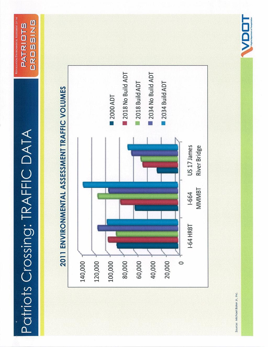
3 Project Description FROM: I-564 Intermodal Connector TO: I-664 & VA-164 DESCRIPTION OF WORK: Segment 1 New 4-lane roadway and bridge from I-664 near southern end of Monitor Merrimac Memorial Bridge-Tunnel to planned I-564 Intermodal Connector (shown in blue), including a tunnel section at the Elizabeth River. Segment 3 New 4-lane roadway and bridge from Segment 1 to VA 164. Patriots Crossing 3 1 Estimated Total Project Cost $3.1 to $4.2 Billion 1 Attachment 9 Summary of Project According to the Environmental Assessment Reevaluation of the 2001 Hampton Roads Crossing Study Final Environmental Impact Statement (2011): Candidate Build 9 Segments 1 and 3: Project will help meet growing needs of Port. Project will improve movement of people and goods to and from the region s military bases. Project will have a positive impact on the region s economy. The Hampton Roads Bridge-Tunnel will remain severely congested, with a volume/capacity ratio = 1.48 (Level-of-Service F) in The Monitor-Merrimac Memorial Bridge-Tunnel will be severely congested, with a volume/capacity ratio = 1.93 (Level-of-Service F) in Overview of Project Status Cost Source: Virginia Department of Transportation NEPA Status Final Environmental Assessment Submitted to FHWA: February 2013 Funding Status Study Fully Funded Preliminary Engineering Status N/A Right of Way Status N/A Construction Status N/A
4 2 Attachment 9
5 3 Attachment 9

 at the Hampton Roads Bridge-Tunnel through the year 2040.")
6 Hampton Roads Bridge-Tunnel Project Description FROM: I-64/I-664 (Hampton) TO: I-64/I-564 (Norfolk) DESCRIPTION OF WORK: Widen I-64 from I-664 in Hampton to I-564 in Norfolk Add new bridge-tunnel facility adjacent to current Hampton Roads Bridge-Tunnel Estimated Total Project Cost $4.4 to $6.7 Billion Project Cost Balance 4 Attachment 9 Summary of Project According to the Interstate 64 Hampton Roads Bridge-Tunnel Draft Environmental Impact Study (2012): Project will result in uncongested conditions (Level-of-Service C) at the Hampton Roads Bridge-Tunnel through the year Project improves accessibility between Peninsula and Southside for commuting, tourism, freight movement, military mobility, and hurricane evacuation. Project improves geometric deficiencies including inadequate shoulder width and substandard vertical tunnel clearance, both of which cause congestion and safety problems. Project will have a positive impact on the region s economy. Overview of Project Status Cost Source: Interstate 64 Hampton Roads Bridge-Tunnel Draft Environmental Imapct Study, NEPA Status Draft Environmental Impact Study Approved by FHWA: December 2012 Funding Status Study Fully Funded Preliminary Engineering Status N/A Right of Way Status N/A Construction Status N/A


.")
7 STUDY PURPOSE AND NEED NEXT STEPS At the Citizen Information Meeting in July 2011, VDOT presented the study Purpose and Need for public comment. The Purpose and Need is essential for establishing a basis for alternatives development and evaluation. The purpose of the I-64 HRBT study is to address transportation problems such as inadequate capacity; unpredictable travel times and speeds; and deficient roadways, tunnels, and bridges. For example, the study addresses substandard vertical clearance in the tunnels. The current low clearance results in numerous truck turnarounds that disrupt traffic and create delays for travelers. VDOT and the Federal Highway Administration (FHWA) will take public comments on the Draft EIS, including the retained alternatives, and address them as part of the NEPA process. The next step will be to present the findings of this study to the Commonwealth Transportation Board (CTB). The CTB will identify a preferred alternative from among the four alternatives evaluated in the Draft EIS. A Final EIS will then be prepared to document the preferred alternative for potential FHWA approval in a Record of Decision (ROD). s Considered s Screening The study is scheduled for completion in Spring Should a build alternative be selected and funded, design documents must be completed, and necessary right-of-way acquired, before construction could begin. A range of alternatives was identified at the second Citizen Information Meeting in April These alternatives were screened for their ability to address the corridor s transportation needs. In particular, VDOT reviewed whether each alternative could relieve the substantial congestion in the corridor and improve geometric deficiencies such as tunnel height. s that were deemed not feasible, or would not meet the study Purpose and Need, were not retained. Retained s Four alternatives have been retained for further evaluation. These alternatives are presented in the Draft EIS and at this Public Hearing. The No-Build would involve only routine maintenance with no major improvements to the corridor. DESCRIPTION OF RETAINED ALTERNATIVES Hampton No-Build Build-8 Build-8 Managed Build-10 Comments 6 lanes 6 lanes + 2 new lanes = 8 lanes 6 lanes + 2 new lanes = 8 lanes 6 lanes + 4 new lanes = 10 lanes Existing road has 6 lanes Limited median space Widening occurs to outside of I new lanes = 8 lanes + 4 new lanes = 8 lanes + 6 new lanes = 10 lanes Existing bridge-tunnel has New bridge-tunnel constructed to west of existing bridge-tunnel + 4 new lanes = 8 lanes + 4 new lanes = 8 lanes + 6 new lanes = 10 lanes Existing road has Median space available Widening would occur on inside and outside of I-64 (Approach to bridge and tunnel) HRBT (Bridges and tunnel) Norfolk (Approach to bridge and tunnel) ALTERNATIVE LAYOUT AND TRAFFIC OPERATIONS LOS A C No or minimal congestion Speeds at or near free-flow LOS D Acceptable operation Slight reduction in speed LOS E Significant congestion Noticeable reduction in speed LOS F Failing congestion Unpredictable speed; stop-and-go traffic No-Build Design and Construction Costs $0 The charts below provide the percentage of the corridor in each operation category by alternative. HAMPTON No-Build 33% 56% No-Build What is a Managed Lane? Managed lanes are used to manage traffic so that users can benefit from more reliable travel times. Lanes could be managed using tolls and/or vehicle occupancy restrictions (such as HOV). Buses could also travel in these lanes. NORFOLK 11%2040 Build-8 No-Build 2040 Build Year 2040 Traffic Operations 2040 Build-10 Build-8 No-Build 2040 Build-8 Design and Construction Costs - Approximately $4.8 billion to $6.5 billion The Build-8 Managed would have a similar lane configuration to the Build-8. However, the managed lanes would be separated from the general purpose lanes by a narrow buffer. VDOT would manage the traffic flow in one or more lanes to provide those users with acceptable operation. 7% 8% 2040 Build Build-10 84% HOT Year 2040General Traffic Operations Purpose 2040 Build-10 Build-8 Managed Design and Construction Costs - Approximately $4.8 billion to $6.6 billion HOT General Purpose General Purpose HOT Lanes General Purpose 7% Managed Lane 7% 15% 45% 78% This example assumes one managed lane in each direction that is a high occupancy toll lane (HOT). Free Flow Design and Construction Costs - Approximately $5.7 billion to $7.9 billion The Build-10 would widen I-64 and the HRBT to five travel lanes in each direction for a total of ten lanes throughout the corridor. 55 mph and high Acceptable Operations 55 mph and high Significant Congestion mph Year 2040 Traffic Operations Failing Congestion 0-49 mph I-64 HRBT I-64 N I-64 Norfolk and Hampton I-64 HRBT Build-10 48%I-64 HRBT HOT Free Flow Managed Lanes HOT General Purpose H Managed Lan HOT Managed Lanes No-Build The Build-8 would widen I-64 and the HRBT to four travel lanes in each direction, for a total of eight lanes throughout the corridor. The Build-8 Managed is the same as the Build-8 except that some or all of the travel lanes would be managed to provide more reliable travel times. Level of Service Descriptions Traffic operation and congestion is measured using Level of Service (LOS). LOS is based on letter grades from A for excellent conditions to F for failure conditions. Free Flow 55 mph and higher Operations Acceptable OperationsAcceptable 55 mph and higher 55 mph andand higher 65 mph higher 65 mph 55 mph higher 60-64and mph Build mph Significant CongestionSignificant 50-54Congestion mph mph 7% 11% Failing0 -Congestion 0-49 Failing Congestion 49 mph 0 - mph 49 mph I-64 HRBT I-64 Norfolk and Hampton Study website: Free Flow 55 mph and higher 65 mph and higher Acceptable Operations 55 mph and higher mph Significant Congestion mph mph Failing Congestion 0-49 mph 0-49 mph 81% Year 2040 Traffic Operations HOT General Purpose 5 Attachment m 0-49 m
 0/0 14 /25 14 /25 14/26 Includes right-of-way required from park lands.")
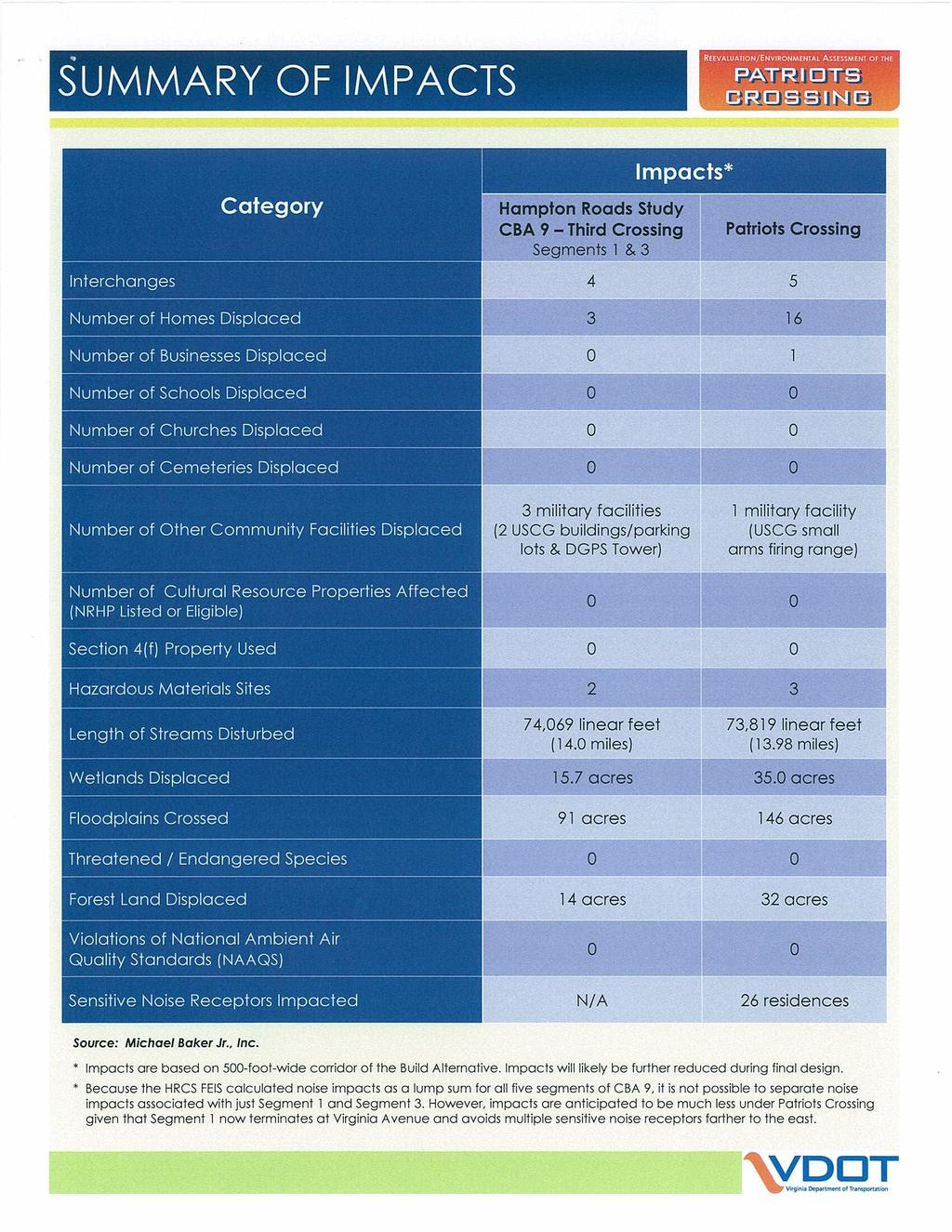
8 ENVIRONMENTAL IMPACT SUMMARY Impact Category No-Build Build-8 Build-8 Managed Build-10 Notes Land acquisition (acres) Acreage indicates amount of right-of-way required. Parks and recreational facilities impacts (number/ acres) 0/0 14 /25 14 /25 14/26 Includes right-of-way required from park lands. Potential residential displacements Potential business displacements Stream impacts (No. of crossings/linear feet of streams) Wetlands impacts (acres) 100-year floodplain impacts (acres) Right-of-way acquisition and relocation would be in accordance with state and federal laws Right-of-way acquisition and relocation would be in accordance with state and federal laws. 0 12/18,200 12/18,300 12/18,500 Includes the extension of existing bridges and culverts, new HRBT approach bridges and tunnel Based on National Wetland Inventory (NWI) data Includes area of new HRBT approach bridges and tunnel. Threatened and endangered species impacts 0 Short-term impacts to 400 acres Short-term impacts to 400 acres Short-term impacts to 415 acres Potential habitat impacts may occur to sea turtles, shortnose sturgeon and Atlantic sturgeon. Submerged aquatic vegetation impacts (acres) Historic architectural resources impacts (no. of properties) Any disturbance would require approval from the Virginia Marine Resources Commission Impacts would include the displacement of historic buildings in historic districts. Air quality impacts 0 Minor short-term impacts Minor short-term impacts Minor short-term impacts The retained alternatives meet all applicable air quality conformity requirements. Noise (no. of sites with noise impact) 817 1,019 1,017 to 1,019 1,017 Abatement measures such as noise barriers would be considered for noise impacts. Parks and Historic Sites Section 4(f) Section 4(f) of the US Department of Transportation Act protects parks and historic sites. The four retained alternatives would impact these properties to varying degrees. VDOT is seeking your comments at this hearing on potential impacts to Section 4(f) properties, particularly impacts that may be considered minor ( de minimis ) impacts as described in the Draft EIS. Historic Properties Section 106 In compliance with Section 106 of the National Historic Preservation Act, information concerning potential effects on properties listed in or eligible for listing in the National Register of Historic Places is available for public comment in the Draft EIS and at this public hearing. 6 Attachment 9


9 Study Schedule WE RE HERE NOW 7 Attachment 9 13
10 TTAC Comments Regarding Studies on Hampton Roads Crossings From the March 6, 2013 TTAC Meeting The following comments were made during a TTAC discussion on the Patriots Crossing Environmental Assessment (Patriots Crossing Study) and the I 64 Hampton Roads Bridge Tunnel Draft Environmental Impact Statement (HRBT Study). 1. Navy concerned that the Patriots Crossing Study was submitted to FHWA before the Navy received responses to comments submitted during the comment period. 2. Concern that the Patriots Crossing does not have a multimodal component. 3. Support for including a multimodal component on Patriots Crossing. 4. Concern that Patriots Crossing does not add capacity between the Peninsula and Southside. 5. HRBT will need significant maintenance/rehabilitation in the future regardless of which project is ultimately selected. 6. Concern about whether an action by the CTB to select a Preferred for the HRBT Study would preclude the ultimate selection of Patriots Crossing as the HRTPO Board s preferred project. VDOT staff will get clarification on possible impacts and will try to have that information ready for the March 21, 2013 HRTPO Board meeting. 7. Concern about potential truck diversion to I 664 en route to US Concern about limitations of the analysis done for the Patriots Crossing Study. Requested more comprehensive history of the Hampton Roads Crossing projects for the HRTPO Board meeting. 8 Attachment 9
11 SUMMARY HISTORY OF STUDIES OF HAMPTON ROADS CROSSINGS PROJECT HISTORY From the Hampton Roads Crossing Study Final Environmental Impact Study: Section 1107 of the Intermodal Surface Transportation Efficiency Act of 1991 (ISTEA) allocated demonstration funds for highway projects demonstrating innovative techniques of highway construction and finance. The I 64 crossing of Hampton Roads was included as one of these innovative projects. In 1992, the Virginia General Assembly passed Joint Resolution 132, which directed the Virginia Department of Transportation (VDOT) to conduct a study on congestion at the Hampton Roads Bridge Tunnel. The subsequent VDOT study stated that short term measures would not solve congestion at the Hampton Roads Bridge Tunnel, and that a long term, large scale solution would be required. The Hampton Roads Crossing Study was initiated in 1993 in response to these two actions, and the results of the VDOT study. PURPOSE The purpose of the Hampton Roads Crossing Study (HRCS) was to develop and analyze intermodal alternatives that could work together to improve accessibility, mobility, and goods movement in the Hampton Roads metropolitan area to help relieve congestion that occurs at the existing I 64 Hampton Roads Bridge Tunnel. CANDIDATE BUILD ALTERNATIVES A three step screening process was used to reduce 45 initial alternatives, ranging from congestion management strategies to constructing a new crossing, to eleven Transportation Corridors, and finally to three Candidate Build s (plus the nobuild alternative) that were evaluated in the Final Environmental Impact Statement (FEIS): 1. Candidate Build 1 would provide a new crossing parallel to the existing I 64 Hampton Roads Bridge Tunnel. On the Peninsula, CBA 1 begins at the I 664 interchange in Hampton and would widen I 64 to the I 564 interchange in Norfolk. A parallel, three tube tunnel typical section to the west of the existing I 64 Hampton Roads Bridge Tunnel would cross Hampton Roads. Two of the tubes would carry two lanes each of eastbound vehicular traffic. The third tube would be used for multimodal travel, and would be dimensioned to accommodate all multimodal possibilities: HOV, passenger rail and/or bus travel. Westbound vehicular traffic would use the four travel lanes in the existing I 64 tunnel tubes. 9 Attachment 9
12 2. Candidate Build 2 would include all of CBA 1, plus a portion of CBA 9. This portion begins at the I 564 and I 64 interchange in Norfolk, crosses the Elizabeth River, runs along the east side of Craney Island, and then connects to VA 164 (Western Freeway) in Portsmouth. 3. Candidate Build 9 would provide a new crossing parallel to the I 664 Monitor Merrimac Memorial Bridge Tunnel with a connection from the new bridge tunnel to Norfolk and Portsmouth. On the Peninsula, CBA 9 begins at the I 64 interchange in Hampton and would widen I 664 to the I 64/I 264 interchange in Chesapeake. CBA 9 includes a new interchange near the south approach structure of the Monitor Merrimac Memorial Bridge Tunnel connecting to a new roadway and bridge tunnel extending from I 664 to I 564 in Norfolk. This interchange would provide access to both the existing Monitor Merrimac Memorial Bridge Tunnel as well as the new parallel bridge tunnel. CBA 9 also includes a connection along the east side of Craney Island to VA 164 (Western Freeway) in Portsmouth. A paralleling, three tube tunnel typical section to the west of the existing I 664 Monitor Merrimac Memorial Bridge Tunnel would cross Hampton Roads. Two of the tubes would carry two lanes each of eastbound vehicular traffic. The third tube would be used for multimodal travel, and would be dimensioned to accommodate all multimodal possibilities: HOV, passenger rail and/or bus travel. Westbound vehicular traffic would use the four travel lanes in the existing I 664 tunnel tubes. A three tube tunnel typical section would cross the entrance to the Elizabeth River and connect to Norfolk. Eastbound and westbound vehicular traffic would be carried in two of the tubes, while the third tube would be used for multimodal travel. RECENT STUDIES Two recently completed studies are related to the HRCS: The Patriots Crossing Study is an Environmental Assessment a reevaluation of the CBA 9, Segments 1 and 3, from the Hampton Roads Crossing Study. The I 64 Hampton Roads Bridge Tunnel Draft Environmental Impact Study (HRBT Study) evaluates the environmental consequences of three build alternatives for the corridor described as CBA Attachment 9
13 TIMELINE Late 1994 the Purpose and Need for the Hampton Roads Crossing project was approved Preliminary list of 45 possible solutions developed and reduced based on criteria established by the Purpose and Need document and the Coordinating Committee. Early 1996 Further refinement and combinations of the original solutions resulted in the development of 11 individual Transportation Corridors. July 1997 Based on findings of the Hampton Roads Crossing Study Major Investment Study (MIS) and citizen input, the MPO selected Transportation Corridor 9 as the Locally Preferred. September 1997 The Commonwealth Transportation Board (CTB) passed a resolution which expressed its good faith intent to facilitate and develop the Hampton Roads Transportation Crossing identified as Transportation Corridor 9. August 1999 Following the Regional Priority Setting process conducted by MPO staff, the MPO voted to add five major regional highway projects (including the Hampton Roads Third Crossing), plus $400 million for regional transit improvements, to the draft 2020 Long Range Transportation Plan (LRTP). October 1997 Hampton Roads Crossing Study Major Investment Study published. October 1999 Hampton Roads Crossing Study Draft Environmental Impact Statement (EIS) published. February 2001 The MPO approved the 2021 LRTP including the Hampton Roads Third Crossing. March 2001 Hampton Roads Crossing Study Final EIS approved by FHWA. November 2003 FHWA approved a reevaluation of the Hampton Roads Crossing Study Final EIS. June 2004 The MPO approved the 2026 LRTP including Segment 1 of the Hampton Roads Third Crossing. December 2007 The MPO approved the 2030 LRTP including Phase 1 of the Hampton Roads Third Crossing. Phase 1 consisted of widening I 664 from the I 664/I 264 interchange in Chesapeake to the I 664/I 64 interchange in Hampton. 11 Attachment 9
14 May 2008 The MPO discussed a $500,000 HRBT study by VDOT. June 2008 Secretary Homer briefed the MPO on the status of the $500,000 HRBT feasibility study by VDOT. December 2009 The MPO approved an amendment to the 2030 LRTP that included changing the Third Crossing Phase 1 project to PE Only. September 2010 VDOT briefed the MPO on a planned $5 million HRBT Draft EIS. January 2011 VDOT requested an amendment to the MPO TIP to add the Patriots Crossing Study. Patriots Crossing is described as a combination of Segments 1 and 3 from Candidate Build (CBA) 9 as described in the Hampton Roads Crossing Study Final EIS. January 2012 The MPO approved the 2034 LRTP including Patriots Crossing and the Hampton Roads Bridge Tunnel as studies. November 2011 FHWA approved the Patriots Crossing Environmental Assessment for public availability. December 2012 FHWA approved the I 64 Hampton Roads Bridge Tunnel Draft EIS. 12 Attachment 9
Fairfax County Transportation Advisory Commission (TAC)
") Fairfax County Transportation Advisory Commission (TAC) January 17, 2017 Susan Shaw, P.E., Megaprojects Director Virginia Department of Transportation Amanda Baxter, Special Projects Development Manager
Fairfax County Transportation Advisory Commission (TAC) January 17, 2017 Susan Shaw, P.E., Megaprojects Director Virginia Department of Transportation Amanda Baxter, Special Projects Development Manager
SR 934 Project Development And Environment (PD&E) Study
 Study") SR 934 Project Development And Environment (PD&E) Study Project Advisory Group Meeting March 1, 2018 State Road 934/NE/NW 79th Street from west of I-95 (NW 13th CT) to N. Bayshore Drive PD&E STUDY SR 934/NE/NW
SR 934 Project Development And Environment (PD&E) Study Project Advisory Group Meeting March 1, 2018 State Road 934/NE/NW 79th Street from west of I-95 (NW 13th CT) to N. Bayshore Drive PD&E STUDY SR 934/NE/NW
Arlington County Board Work Session Eastbound Widening January 17, Amanda Baxter, VDOT Special Projects Development Manager
 Arlington County Board Work Session Eastbound Widening January 17, 2017 Amanda Baxter, VDOT Special Projects Development Manager Program Area Map 2 Program Scope Tolling during weekdays, peak hours, peak
McLean Citizens Association Transportation Committee Project Briefing
 McLean Citizens Association Transportation Committee Project Briefing November 10, 2015 Project Map 2 Project Context Only Interstate in the Country limited to HOV only traffic during rush hours Stoplight
Elected Officials and Media Briefing I-395 Express Lanes Northern Extension
 Elected Officials and Media Briefing I-395 Express Lanes Northern Extension Updates on: I-95 Express Lanes Southern Extension Transform 66: Inside and Outside the Beltway March 31, 2016 Today s Agenda
Design Public Hearing
 Design Public Hearing Monday, March 7, 2016 Washington-Lee High School Cafeteria 1301 N. Stafford Street, Arlington, VA 22201 Tuesday, March 8, 2016 Eagle Ridge Middle School Cafeteria 42901 Waxpool Road,
Arlington County Board Meeting Project Briefing. October 20, 2015
 Arlington County Board Meeting Project Briefing October 20, 2015 Project Map 2 Project Context Only Interstate in the Country limited to HOV only traffic during rush hours Stoplight at the end of I-66
Public Information Meetings. October 5, 6, 7, and 15, 2015
 Public Information Meetings October 5, 6, 7, and 15, 2015 Project Map 2 Project Context Only Interstate in the Country limited to HOV only traffic during rush hours Stoplight at the end of I-66 eastbound
Interstate 90 and Mercer Island Mobility Study APRIL Commissioned by. Prepared by
 Interstate 90 and Mercer Island Mobility Study APRIL 2017 Commissioned by Prepared by Interstate 90 and Mercer Island Mobility Study Commissioned by: Sound Transit Prepared by: April 2017 Contents Section
I-66 Inside the Beltway Feasibility Study
 I-66 Inside the Beltway Feasibility Study Feasibility Study Study Process Context Sensitive Dialogues Corridor Assessments / Data Collection Problem Statement Refinement Concept Development Concept Evaluation
US 380 FEASIBILITY STUDY
 US 380 FEASIBILITY STUDY Denton County CSJ(s): 0135-10-061, 0135-10-062 Public Meeting(s): January 15 & 22, 2019 WELCOME US 380 Denton County Feasibility Study DALLAS DISTRICT PUBLIC MEETING January 15
Project Overview. Hunter Mill Road Over Colvin Run Bridge Replacement Fairfax County. Get Involved. Public Information Meeting. Contact Information
 Get Involved VDOT representatives will review and evaluate any information received as a result of the public information meeting. The comment sheet in this brochure is provided to assist in making your
Hampton Roads Express Lane Network
 More Choices For Travelers Hampton Roads Express Lane Network James Utterback, PMP Hampton Roads District Administrator Presented to HRTPO Board July 20, 2017 Regional Express Lane Network 2 History of
Moving the Economy. To HRTPO Board November 16, 2017 By Robert B. Case, PE, PhD
 Moving the Economy To HRTPO Board November 16, 2017 By Robert B. Case, PE, PhD Moving the Economy How Well the Hampton Roads Transportation System Serves Three Key Economic Sectors: Port Military Hospitality
SECTION 106 ACTIVITIES ANNUAL REPORT
 SECTION 106 ACTIVITIES ANNUAL REPORT FOR THE YEAR ENDING DECEMBER 31, 2011 Metropolitan Washington Airports Authority 1593 Spring Hill Road, Suite 300 Vienna, Virginia 22182 JANUARY 2012 Introduction The
395 Express Lanes Project Update
 395 Express Lanes Project Update Key Dates Milestone Date Limited Notice to Proceed February 2017 Early Works March-June 2017 Full Notice to Proceed July 2017 Preparatory Work Summer 2017 Draft Noise Abatement
Frequently Asked Questions on the Route 29 Solutions Improvements Projects
 Frequently Asked Questions on the Route 29 Solutions Improvements Projects Background What are the Route 29 Solutions improvement projects? These projects include the Route 29/250 Interchange ( Best Buy
Memorandum. Roger Millar, Secretary of Transportation. Date: April 5, Interstate 90 Operations and Mercer Island Mobility
 Memorandum To: From: The Honorable Dow Constantine, King County Executive; The Honorable Ed Murray, City of Seattle Mayor; The Honorable Bruce Bassett, City of Mercer Island Mayor; The Honorable John Stokes,
Draft Concept Alternatives Analysis for the Inaugural Airport Program September 2005
 Section 10 Preferred Inaugural Airport Concept 10.0 Introduction The Preferred Inaugural Airport Concept for SSA was developed by adding the preferred support/ancillary facilities selected in Section 9
Treasure Island Supplemental Information Report Addendum
 1 1 1 1 0 1 0 1 0 1 Treasure Island Supplemental Information Report Addendum Introduction Purpose The purpose of this Supplemental Information Report (SIR) Addendum is to determine if the current land
SECTION 106 ACTIVITIES ANNUAL REPORT
 SECTION 106 ACTIVITIES ANNUAL REPORT FOR THE YEAR ENDING DECEMBER 31, 2014 Metropolitan Washington Airports Authority 198 Van Buren Street, Suite 300 Herndon, Virginia 20170 JANUARY 2015 Introduction The
US 83 Relief Route. City of La Joya City of Peñitas Hidalgo County. November 15, 2012
 US 83 Relief Route City of La Joya City of Peñitas Hidalgo County November 15, 2012 TxDOT Mission: Work with others to provide safe and reliable transportation solutions for Texas. Public Meeting Agenda
Basic Project Information
 FY 2015-16 PROJECT DESCRIPTION FORM (2C) Submitting Agency: Loudoun County Basic Project Information Project Title: Loudoun County Parkway (VA Route 607) U.S. 50 to Creighton Rd. (2C) Project Type (check
Rural Rustic Road Program
 Virginia Department of Transportation s Rural Rustic Road Program Prepared by the Local Assistance Division Virginia Department of Transportation 1401 East Broad Street Richmond, Virginia 23219 Michael
Marti Donley; Daniel Reese; Rodney White UPC FFY14 TIP AMD pdf
 Marti Donley From: Sent: To: Cc: Subject: Attachments: Lloyd Robinson Thursday, October 10, 2013 8:14 AM Andy Waple jason.robinson@vdot.virginia.gov; Marti Donley; Daniel Reese; Rodney White FW: TIP Amendment
Presented By: Deputy Executive Director February 17, 2011
 TRANSPORTATION PROJECT PRIORITIZATION Presented By: Camelia Ravanbakht, Ph.D. Ca e a aaba t,.. Deputy Executive Director February 17, 2011 OVERVIEW 2034 Long-Range g Transportation Plan (LRTP) Process
Dulles Corridor Metrorail Project Update Dulles Area Transportation Association August 25, 2009
 Dulles Corridor Metrorail Project Update Dulles Area Transportation Association August 25, 2009 Patty Nicoson President Dulles Corridor Rail Association Proposed Toll Rate Increase on Dulles Toll Road
Memorandum. Fund Allocation Fund Programming Policy/Legislation Plan/Study Capital Project Oversight/Delivery Budget/Finance Contract/Agreement Other:
 Memorandum Date: March 23, 2018 To: Transportation Authority Board From: Eric Cordoba Deputy Director Capital Projects Subject: 4/10/18 Board Meeting: San Francisco Freeway Corridor Management Study Update
CONTACT: Michelle T. Holland
 FOR IMMEDIATE RELEASE Thursday, December 7, 2017 CONTACT: Michelle T. Holland 703-586-0487 (C) Michelle.Holland@vdot.virginia.gov Jennifer McCord 571-230-2926 Jennifer.McCord@vdot.virginia.gov 66 EXPRESS
5.1 Traffic and Transportation
 5.1 When it opens in 2009, the Bellevue Nickel Improvement Project will increase the number of vehicles able to travel through the study area, improve travel speeds, and improve safety by reducing the
A. CONCLUSIONS OF THE FGEIS
 Chapter 11: Traffic and Parking A. CONCLUSIONS OF THE FGEIS The FGEIS found that the Approved Plan will generate a substantial volume of vehicular and pedestrian activity, including an estimated 1,300
WELCOME TO THE OPEN HOUSE
 WELCOME TO THE OPEN HOUSE US 281 North Loop 1604 to Borgfeld Drive CSJ: 0253-04-146 & 0253-04-138 May 12, 2016 Please sign in Explore the exhibits Submit a comment form Ask questions We want to know your
Public Informational Meeting
 Public Informational Meeting April 17, 2007 Bow-Concord I-93 I Transportation Planning Study Bow-Concord Interstate 93 Transportation Planning Study Context Sensitive Solutions Planning Steps Screen Alternatives
2017 TBARTA Future Regional Priority Projects Adopted by TBARTA Board, December 9, 2016
 2017 TBARTA Future Regional Priority Projects Adopted by TBARTA Board, December 9, 2016 Project numbers do not signify ranking they are for mapping identification purposes only. 1. 15th Street East The
Lake Tahoe Airport Master Plan Public Meeting March 16, 2015
 Lake Tahoe Airport Master Plan Public Meeting March 16, 2015 What is an Airport Master Plan? a comprehensive study of an airport [that] usually describes the short, medium, and long term development plans
CITY MANAGER S OFFICE CITY OF MERCER ISLAND, WASHINGTON 9611 SE 36 th Street Mercer Island, WA (206)
") CITY MANAGER S OFFICE CITY OF MERCER ISLAND, WASHINGTON 9611 SE 36 th Street Mercer Island, WA 98040-3732 (206) 275-7600 www.mercergov.org August 18, 2016 Mr. Daniel M. Mathis Division Administrator Federal
CITY MANAGER S OFFICE CITY OF MERCER ISLAND, WASHINGTON 9611 SE 36 th Street Mercer Island, WA 98040-3732 (206) 275-7600 www.mercergov.org August 18, 2016 Mr. Daniel M. Mathis Division Administrator Federal
MONTEREY REGIONAL AIRPORT MASTER PLAN TOPICAL QUESTIONS FROM THE PLANNING ADVISORY COMMITTEE AND TOPICAL RESPONSES
 MONTEREY REGIONAL AIRPORT MASTER PLAN TOPICAL QUESTIONS FROM THE PLANNING ADVISORY COMMITTEE AND TOPICAL RESPONSES Recurring topics emerged in some of the comments and questions raised by members of the
DULLES AREA HIGHLIGHTS. Gary Garczynski Commonwealth Transportation Board Northern Virginia District. Committee for Dulles August 4, 2016
 DULLES AREA HIGHLIGHTS Gary Garczynski Commonwealth Transportation Board Northern Virginia District Committee for Dulles August 4, 2016 Smart Scale (formerly HB2) Overview Round 1 completed with the adoption
Fairfax County Parkway Widening Fairfax County
 Get Involved VDOT representatives will review and evaluate information received as a result of this meeting. Please fill out the comment sheet provided in this brochure if you have any comments or questions.
FIRST WEEK UPDATE: 66 EXPRESS LANES INSIDE THE BELTWAY Data from first four days shows faster, more reliable trips on I-66
 FOR IMMEDIATE RELEASE Tuesday, December 12, 2017 CONTACT: Michelle T. Holland 703-586-0487 (C) Michelle.Holland@vdot.virginia.gov Jennifer McCord 571-230-2926 Jennifer.McCord@vdot.virginia.gov FIRST WEEK
This page intentionally left blank
 This page intentionally left blank Prepared for: Nevada Department of Transportation Prepared by: July 2015 This page intentionally left blank Table of Contents Executive Summary... ES-1 ES.1. HOV System
FIRST WEEK UPDATE: 66 EXPRESS LANES INSIDE THE BELTWAY Data from first four days shows faster, more reliable trips on I-66
 Subject: FIRST WEEK UPDATE: 66 EXPRESS LANES INSIDE THE BELTWAY From: VDOT-News To: Time: Tuesday, December 12, 2017 9:05:36 AM -08:00 RELEASE: IMMEDIATE Michelle Holland,
Report to the Dulles Corridor Advisory Committee
 Report to the Dulles Corridor Advisory Committee Information Report on Dulles Toll Road Toll Rate Adjustment Process and Tentative Schedule and Overview of Traffic and Revenue Study Update May 2018 Purpose
Longmont to Boulder Regional Trail Jay Road Connection DRAFT FINAL REPORT
 Longmont to Boulder Regional Trail Jay Road Connection DRAFT FINAL REPORT December 2018 Project Summary Boulder County, Colorado, in partnership with the City of Boulder, is evaluating options for multi-use
2008 DEKALB COUNTY TRANSPORTATION PLAN (UPDATE)
") 2008 DEKALB COUNTY TRANSPORTATION PLAN (UPDATE) TABLE OF CONTENTS Introduction 1 Transportation Planning Activities 2 Identification of Problem Areas and Recommended Solutions 7 DeKalb County Projects
2008 DEKALB COUNTY TRANSPORTATION PLAN (UPDATE) TABLE OF CONTENTS Introduction 1 Transportation Planning Activities 2 Identification of Problem Areas and Recommended Solutions 7 DeKalb County Projects
2016 Regional Transportation Alternatives Program (TAP) Grant Application
 Grant Application") 2016 Regional Transportation Alternatives Program (TAP) Grant Application PROJECT TITLE: Yelm-Tenino Trail Extension Feasibility Study TRPC use only GENERAL PROJECT INFORMATION Agency or Organization City
2016 Regional Transportation Alternatives Program (TAP) Grant Application PROJECT TITLE: Yelm-Tenino Trail Extension Feasibility Study TRPC use only GENERAL PROJECT INFORMATION Agency or Organization City
Virginia Department of Transportation s Rural Rustic Road Program
 Virginia Department of Transportation s Rural Rustic Road Program Prepared by the Local Assistance Division Virginia Department of Transportation 1401 East Broad Street Richmond, Virginia 23219 Michael
PDF compression, OCR, web optimization using a watermarked evaluation copy of CVISION PDFCompressor
 o U.S. Department Washington Division Suite 501 Evergreen Plaza of Transportation 711 South Capitol Way Olympia, Washington 98501-1284 Federa' Highway (360) 753-9480 Administration (360) 753-9889 (FAX)
Transportation TRANSPORTATION PROJECTS
 Transportation TRANSPORTATION PROJECTS Balls Ford Road Interchange Total Project Cost $142.9M This project includes the construction of a new diverging diamond interchange at Route 234 Bypass (Prince William
Route 29 Solutions Projects
 Your guide to the Route 29 Solutions Projects For full details & continued engagement please visit www.route29solutions.org The Route 29 Solutions Package is a $230 million investment into the improvement
Draft Concept Alternatives Analysis for the Inaugural Airport Program September 2005
 Draft Concept Alternatives Analysis for the Inaugural Airport Program September 2005 Section 3 - Refinement of the Ultimate Airfield Concept Using the Base Concept identified in Section 2, IDOT re-examined
Silver Line Operating Plan
 Customer Service and Operations Committee Information Item IV-A December 6, 2012 Silver Line Operating Plan Washington Metropolitan Area Transit Authority Board Action/Information Summary Action Information
Flying Cloud Airport Joint Airport Zoning Board. 27 February 2018 Public Hearing #1 Overview of Proposed Airport Zoning Ordinance
 Flying Cloud Airport Joint Airport Zoning Board 27 February 2018 Public Hearing #1 Overview of Proposed Airport Zoning Ordinance Presentation Agenda Purpose & Goals Review of FCM Zoning Historical Timeline
Transform66 Transportation Management Plan: Transit & TDM Strategies
 Transform66 Transportation Management Plan: Transit & TDM Strategies Commuter Connections Committee November 15, 2016 1 Transforming I-66 A short introduction. http://outside.transform66.org/meetings/video_recordings.asp
A. From I-68 in Monongalia County, West Virginia to SR 6119 in Fayette County, Pennsylvania 1
 Mon-Fayette Transportation Project A. From I-68 in Monongalia County, West Virginia to SR 6119 in Fayette County, Pennsylvania 1 The Mon/Fayette Transportation Project (MFTP) from I-68 in West Virginia
FEDERAL HIGHWAY ADMINISTRATION NEVADA DEPARTMENT OF TRANSPORTATION ENVIRONMENTAL IMPACT STATEMENT RE-EVALUATION
 FEDERAL HIGHWAY ADMINISTRATION NEVADA DEPARTMENT OF TRANSPORTATION ENVIRONMENTAL IMPACT STATEMENT RE-EVALUATION Project Name: Boulder City/US 93 Corridor Study (Boulder City Bypass) Project Location: The
PURPOSE AND NEED (CONCURRENCE POINT 1) NEW CANADA ROAD PROJECT FROM STATE ROUTE 1 (U.S. HIGHWAY 70) TO U.S. INTERSTATE 40
 NEW CANADA ROAD PROJECT FROM STATE ROUTE 1 (U.S. HIGHWAY 70) TO U.S. INTERSTATE 40") PURPOSE AND NEED (CONCURRENCE POINT 1) NEW CANADA ROAD PROJECT FROM STATE ROUTE 1 (U.S. HIGHWAY 70) TO U.S. INTERSTATE 40 Project Description The primary purpose of this project is to improve the major
PURPOSE AND NEED (CONCURRENCE POINT 1) NEW CANADA ROAD PROJECT FROM STATE ROUTE 1 (U.S. HIGHWAY 70) TO U.S. INTERSTATE 40 Project Description The primary purpose of this project is to improve the major
San Mateo County Transportation Authority Board Meeting November 2, 2017 Item #10 1
 San Mateo County Transportation Authority Board Meeting November 2, 2017 Item #10 1 OVERVIEW Brief recap from October Traffic Analysis Findings Draft Environmental Document Summarized Outcomes Questions
Other Principle Arterials Minor Arterial Major Collector Minor Collector Local
 CHAPTER 10 TRANSPORTATION Introduction The system of public roads in East Pikeland Township is decidedly rural in character. Since the 1984, the road network has remained much the same, with the addition
FNORTHWEST ARKANSAS WESTERN BELTWAY FEASIBILITY STUDY
 FNORTHWEST ARKANSAS WESTERN BELTWAY FEASIBILITY STUDY EXECUTIVE SUMMARY The 2030 Northwest Arkansas Regional Transportation Plan developed by the Northwest Arkansas Regional Planning Commission (NWARPC)
Lake Erie Commerce Center Traffic Analysis
 LOCATION: East of NYS Route 5 at Bayview Road Town of Hamburg Erie County, New York PREPARED BY: Wendel Companies 140 John James Audubon Parkway Suite 200 Amherst, New York 14228 January 2012 i ii Table
Blueways: Rivers, lakes, or streams with public access for recreation that includes fishing, nature observation, and opportunities for boating.
 Parks, Open Space and Trails PRINCE WILLIAM COUNTY 2008 COMPREHENSIVE PLAN TRAILS PLAN CONTENTS The components of the trails plan are: Intent Definitions Goals, Policies, and Action Strategies Trails Map
Community Development
 Community Development City & Borough of Juneau Community Development 155 S. Seward Street Juneau, AK 99801 (907) 586 0715 Phone (907) 586 4529 Fax DATE: February 11, 2016 TO: FROM: Planning Commission
HOV LANE PERFORMANCE MONITORING: 2000 REPORT EXECUTIVE SUMMARY
 Final Report Research Project Agreement No. T1803, Task 4 HOV Monitoring V HOV LANE PERFORMANCE MONITORING: 2000 REPORT EXECUTIVE SUMMARY by Jennifer Nee TRAC Research Engineer John Ishimaru TRAC Senior
Report to the Strategic Development Committee
 Report to the Strategic Development Committee Recommendation to Approve the Request of Virginia Department of Transportation for Easements across Washington Dulles International Airport Property at Route
SUPPORT THE ROUTE 58 PPTA: A Good Investment in Virginia
 Project Profile: SUPPORT THE ROUTE 58 PPTA: A Good Investment in Virginia In 1989, the General Assembly established the Route 58 Corridor Development Program to enhance economic development potential across
BOARD OF SUPERVISORS AND VIRGINIA DEPARTMENT OF TRANSPORTATION JOINT PUBLIC HEARING
 BOARD OF SUPERVISORS AND VIRGINIA DEPARTMENT OF TRANSPORTATION JOINT PUBLIC HEARING Date of Hearing: September 14, 2016 #1 SUBJECT: ELECTION DISTRICT: Proposed FY2017-FY2022 Secondary Road Six-Year Plan
FHWA P/N Guidelines. Corridor Relationship. Highway 22 Segment 1 - US 169 to CSAH 2 Relevance / Documentation of Need
 Highway 22 Segment 1 - US 169 to CSAH 2 Vehicle Mobility Congestion Intersection Congestion Existing Conditions - Based on Highway Capacity Manual methodology, corridor level of service is currently LOS
REPORT TO THE STRATEGIC PLANNING AND DEVELOPMENT COMMITTEE
 REPORT TO THE STRATEGIC PLANNING AND DEVELOPMENT COMMITTEE INFORMATION REPORT ON METROPOLITAN WASHINGTON AIRPORTS AUTHORITY SUPPORT TO REGIONAL TRANSPORTATION PLANNING EFFORTS JUNE 2013 Purpose To inform
CatExes vs. EAs When and How to Prepare
 CatExes vs. EAs When and How to Prepare Panel: Steve Culberson, Ricondo & Associates Frank Smigelski, FAA Mary Vigilante, Synergy Tuesday December 10, 2013 Washington, DC 1 So you have a project Do I have
South Norfolk Jordan Bridge a private proposal by FIGG Bridge Developers. Chesapeake City Council Update June 23, 2009
 South Norfolk Jordan Bridge a private proposal by FIGG Bridge Developers Chesapeake City Council Update June 23, 2009 A Private Bridge Proposal To: Restore a critical regional transportation link Reconnect
Resolution of Support for the Ettrick Site as the Future Location of the Tri-Cities Multimodal Station
 CHESTERFIELD COUNTY BOARD OF SUPERVISORS Page 1 of 3 AGENDA Meeting Date: October 28, 2015 Item Number: 8.B.1.b. Subject: Resolution of Support for the Ettrick Site as the Future Location of the Tri-Cities
Section 4(f) and Section 6(f) Technical Analysis
 and Section 6(f) Technical Analysis") WESTSIDE SUBWAY EXTENSION PROJECT Contract No. PS-4350-2000 Section 4(f) and Section 6(f) Technical Analysis Prepared for: Prepared by: WSP USA 851 SW Sixth Avenue, Suite 1600 Portland, Oregon 97204 FEBRUARY
WESTSIDE SUBWAY EXTENSION PROJECT Contract No. PS-4350-2000 Section 4(f) and Section 6(f) Technical Analysis Prepared for: Prepared by: WSP USA 851 SW Sixth Avenue, Suite 1600 Portland, Oregon 97204 FEBRUARY
STUDY OVERVIEW MASTER PLAN GOALS AND OBJECTIVES
 INTRODUCTION An Airport Master Plan provides an evalua on of the airport s avia on demand and an overview of the systema c airport development that will best meet those demands. The Master Plan establishes
Project Application. General Information ODOT PID. ODOT District. Primary County (3 char abrv)
") Current Status (Tier 1, Tier 2 or New) Proposed Status (Tier 1 or Tier 2) Project Application General Information ODOT PID ODOT District Primary County (3 char abrv) Facility Name (i.e. route, rail, terminal,
Current Status (Tier 1, Tier 2 or New) Proposed Status (Tier 1 or Tier 2) Project Application General Information ODOT PID ODOT District Primary County (3 char abrv) Facility Name (i.e. route, rail, terminal,
MEMORANDUM. Lynn Hayes LSA Associates, Inc.
 MEMORANDUM To: Lynn Hayes LSA Associates, Inc. Date: May 5, 217 From: Zawwar Saiyed, P.E., Senior Transportation Engineer Justin Tucker, Transportation Engineer I Linscott, Law & Greenspan, Engineers LLG
Hampton Roads District Council of The Urban Land Institute. Craney Island Marine Terminal Update
 Hampton Roads District Council of The Urban Land Institute Craney Island Marine Terminal Update Mr. Jeff Keever Senior Deputy Executive Director Virginia Port Authority June 29, 2011 The Port of Virginia
A number of goals were identified during the initial work on this Big Lake Transportation Plan.
 C. Transportation General Background Information Big Lake s transportation system includes all the roads, paths and facilities that allow the movement of private vehicles, trains and planes, as well as
Transform66: Inside the Beltway
 Transform66: Inside the Beltway Result of a multi-year planning that started during the McDonnell Administration 2016 compromise reached with General Assembly Convert I-66 to express lanes from 5:30a-9:30a
Construction underway. STATUS: 229 5,190 5,419 5,305 STIP REFERENCE #FR /01/2013
 FREDERICK COUNTY STATE HIGHWAY ADMINISTRATION -- Frederick County -- Line 1 PROJECT: I-7, Baltimore National Pike INTERSTATE CONSTRUCTION PROGRAM DESCRIPTION: Widen I-7 east of MD 355 to east of MD 144
1.0 PURPOSE OF AND NEED FOR ACTION
 1.0 PURPOSE OF AND NEED FOR ACTION 1.1 NEED FOR ACTION Federal legislation initially designated Interstate 73 (I-73) as a high priority corridor in the Intermodal Surface Transportation Efficiency Act
Department of Public Works P.O Box 4186, San Rafael, CA / Fax: 415/
 Department of Public Works P.O Box 4186, San Rafael, CA 94913-4186 415/499-7877 Fax: 415/499-3724 Raul M. Rojas DIRECTOR San Antonio Road Bridge Replacement September 9, 2015 Community Meeting Summary
MEETING MINUTES Page 1 of 5
 Page 1 of 5 50178.000 May 26, 2009 PROJECT PROJECT NO. MEETING DATE ISSUE DATE Citizens Advisory Committee Meeting MEETING LOCATION MEETING PURPOSE Amy Eckland ISSUED BY SIGNATURE PARTICIPANT See attached
Aviation, Rail, & Trucking 6-1
 6-1 This chapter describes the services, facilities, and condition of air, rail, and trucking as components of the transportation system. These three intermodal areas have an impact on the factors to be
Lake Tahoe Airport Master Plan
 Lake Tahoe Airport Master Plan City Council Briefing October 20, 2015 What is an Airport Master Plan? a comprehensive study of an airport [that] usually describes the short, medium, and long term development
1.2 Corridor History and Current Characteristics
 SECTION 1 Description and Background of Study Area 1.1 Introduction This preliminary engineering report was prepared for the Alaska Department of Transportation and Public Facilities (ADOT&PF). It is part
AGENDA ITEM 5 D WAKULLA ENVIRONMENTAL INSTITUTE (WEI) TRAIL FEASIBILITY STUDY
 TRAIL FEASIBILITY STUDY") March 19, 2018 AGENDA ITEM 5 D WAKULLA ENVIRONMENTAL INSTITUTE (WEI) TRAIL FEASIBILITY STUDY TYPE OF ITEM: Action STATEMENT OF ISSUE The Wakulla Environmental Institute (WEI) Trail is one of several trails
March 19, 2018 AGENDA ITEM 5 D WAKULLA ENVIRONMENTAL INSTITUTE (WEI) TRAIL FEASIBILITY STUDY TYPE OF ITEM: Action STATEMENT OF ISSUE The Wakulla Environmental Institute (WEI) Trail is one of several trails
Engagement Summary Report. Trans-Canada Highway 1 RW Bruhn Bridge Replacement Project. Community Engagement November 15, 2016 to January 15, 2017
 Trans-Canada Highway 1 RW Bruhn Bridge Replacement Project Community Engagement November 15, 2016 to January 15, 2017 Engagement Summary Report February 2017 Prepared by Kirk & Co. Consulting Ltd. Trans-Canada
Report to the Strategic Development Committee
 Report to the Strategic Development Committee Request of Virginia Department of Transportation for Easements across Washington Dulles International Airport Property at Route 28 May 2016 PURPOSE Staff requests
Bradley Brook Relocation Project. Scoping Notice. Saco Ranger District. United States Department of Agriculture Forest Service
 Bradley Brook Relocation Project United States Department of Agriculture Forest Service Scoping Notice White Mountain National Forest February 2011 For Information Contact: Jenny Burnett White Mountain
Final Environmental Impact Statement for the Merced Wild and Scenic River. Comprehensive Management Plan, Yosemite National Park, Madera and Mariposa
 This document is scheduled to be published in the Federal Register on 02/26/2014 and available online at http://federalregister.gov/a/2014-04061, and on FDsys.gov DEPARTMENT OF THE INTERIOR 4312-FF NATIONAL
1 PROJECT STATUS UPDATE 2 ND CONCESSION FROM BRISTOL ROAD TO DOANE ROAD TOWNS OF EAST GWILLIMBURY AND NEWMARKET
 Report No. 3 of the Regional Council Meeting of March 28, 2013 1 PROJECT STATUS UPDATE 2 ND CONCESSION FROM BRISTOL ROAD TO DOANE ROAD TOWNS OF EAST GWILLIMBURY AND NEWMARKET The recommends: 1. Receipt
US 83 FROM NORTH OF THE STARR/ZAPATA COUNTY LINE TO LOMA BLANCA ROAD
 US 83 FROM NORTH OF THE STARR/ZAPATA COUNTY LINE TO LOMA BLANCA ROAD PUBLIC MEETING JUNE 8, 2017 Talk Text Crash 2 AGENDA TECHNICAL PRESENTATION (Roma Area Engineer Eduardo Gracia, P.E.) PROJECT SCHEDULE
Major Projects Overview
 Major Projects Overview Miami-Dade Expressway Authority February 2018 About MDX MDX operates 5 roads in Miami Dade County SR 924, SR 112, SR 836, SR 874 and SR 878 MDX Primary Source of Revenue: User Fees-Tolls
Section II. Planning & Public Process Planning for the Baker/Carver Regional Trail began in 2010 as a City of Minnetrista initiative.
 Section II Planning & Public Process Planning for the began in 2010 as a City of initiative. city staff began discussions with the Park District on the possibility of a north/south regional trail connection
Selection of a Locally Preferred Alternative for the Interstate 405 Improvement Project Between State Route 55 and Interstate 605.
 ORANGE COUNTY TRANSPORTATION AUTHORITY Selection of a Locally Preferred Alternative for the Interstate 405 Improvement Project Between State Route 55 and Interstate 605 PowerPoint San Diego Freeway (Interstate
I-3 DFW Extension Public Hearing. June 2, 2011
 1 I-3 DFW Extension Public Hearing June 2, 2011 2 DFW LRT Extension Agenda: Introductions Service Plan Amendment Alignment, Grade Separations, Station, Yard Environmental Assessment Environmental Impacts/Mitigation
MEMORANDUM. FROM: John A. Bishop, AICP, Assistant Director - Transportation. May 22, 2017 Transportation Committee Meeting
 COUNTY of FREDERICK Department of Planning and Development 540/ 665-5651 Fax: 540/ 665-6395 MEMORANDUM TO: Frederick County Transportation Committee FROM: John A. Bishop, AICP, Assistant Director - Transportation
 Executive Summary This document contains the Master Plan for T. F. Green Airport. The goal of a master plan is to provide a framework of potential future airport development in a financially feasible manner,
INTERSTATE 10 AND INTERSTATE 17 SPINE WORKSHOP
 October 31, 2012 INTERSTATE 10 AND INTERSTATE 17 SPINE WORKSHOP ADOT FHWA MAG City of Phoenix City of Tempe City of Chandler Valley Metro/RPTA October 31, 2012 1 Agenda Introductions Background Purpose