Table 1: Iron Mountain Communication Site. Latitude 1 Longitude 1 Elev 2 Address T/R/S 3 APN 4 USGS Quadrangle
|
|
|
- Egbert Lynch
- 6 years ago
- Views:
Transcription
1 County of Riverside Public Safety Enterprise Communication Project Appendix A: Candidate Site Descriptions Overview The site is located in San Bernardino County near several communication towers in the Iron Mountains, approximately 1 mile west of the Metropolitan Water District s (MWD) Iron Mountain Pumping Plant, and approximately 9 miles north-northeast of the junction of State Route 62 and State Route 177. The proposed project will place a tower and equipment shelter at the site. Table 1: Latitude 1 Longitude 1 Elev 2 Address T/R/S 3 APN 4 USGS Quadrangle ,920 Iron Mountain Road, Earp, CA N 17E Sec (SB) Iron Mtns. 1 All coordinates utilize NAD83 datum 2 All elevations in feet above mean sea level 3 Township/Range/Section (San Bernardino Base Meridian) 4 All Assessors Parcel Numbers are located in Riverside County, unless noted: OC = Orange County; SD = San Diego County; SB = San Bernardino County Surrounding Land Uses The Iron Mountains are very isolated, and with the exception of the MWD facility and associated Colorado River Aqueduct, there is minimal human activity in the area. The MWD pumping plant is located approximately 1 mile east of the site at the base of the mountain, and houses the pumping plant, holding ponds, a small residential area, and the aqueduct itself. The project site is atop a mountain overlooking this MWD facility. Two MWD communication towers are positioned on a ridge approximately 900 feet northwest of the proposed tower site. Topography and Vegetation The project site is located atop a mountain peak in the eastern portion of the Iron Mountains, and overlooks Ward Valley to the northeast, east, and southeast. The Old Woman Mountains lie across Ward Valley to the north, and the Granite Mountains are visible across the valley to the south. The site itself is a graded pad atop a ridge, and is largely void of vegetation. Vegetation on the surrounding areas of the mountain is sparse, and is composed of brittlebush, burro-weed, creosote bush, and ephedra. Land Ownership and Applicable Habitat/Land Management Plan The site is located in San Bernardino County and is located on lands that are owned and operated by the MWD. It is not located within the boundaries of any regional resource management plan, such as a habitat conservation plan. Road Access A dirt road accesses the site from the MWD facility at the base of the mountain. 1 H:\Client\2749\ \ADEIR_ \Appendices\App A Candidate Site Descriptions\Iron Mountain.doc
2 County of Riverside Public Safety Enterprise Communication Project Appendix A: Candidate Site Descriptions Commercial Power Access Commercial power is located at the nearby MWD towers, approximately 900 feet to the northwest of the site. Power will be brought in via a pole line from the MWD tower sites along the access road. 2 H:\Client\2749\ \ADEIR_ \Appendices\App A Candidate Site Descriptions\Iron Mountain.doc
3 Candidate Location! NORTH Source: USGS Iron Mountains 7.5' Topographic Map. 2,000 1, /2008 iron_mountains.mxd 0 2,000 Feet Local Vicinity Topographic Map COUNTY OF RIVERSIDE PUBLIC SAFETY ENTERPRISE COMMUNICATION PROJECT


4 ! Legend! Candidate Location NORTH Source: San Bernardino County NAIP, /2008 iron_mountain_aerial.mxd Feet Local Vicinity Aerial Map COUNTY OF RIVERSIDE PUBLIC SAFETY ENTERPRISE COMMUNICATION PROJECT


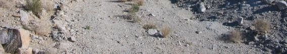
5 Photograph 1: View toward Iron Mountain candidate location, facing east. Photograph 2: View toward Iron Mountain candidate location, facing west. Photograph 3: View toward Iron Mountain candidate location, facing east-northeast. Source:, /2008 Iron Mountain_Photo1.doc Photograph 4: View toward Iron Mountain candidate location from an adjacent ridge, facing southeast. Iron Mountain Candidate Photographs 1 to 4 PSEC Project


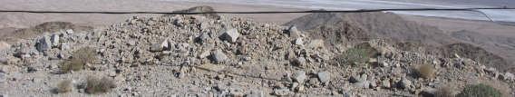
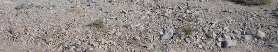
6 Photograph 5: View from Iron Mountain candidate location, facing east. Photograph 6: View from Iron Mountain candidate location, facing south. Photograph 7: View from Iron Mountain candidate location, facing southwest. Source:, /2008 Iron Mountain_Photo2.doc Photograph 8: View from Iron Mountain candidate location, facing northwest. Iron Mountain Candidate Photographs 5 to 8 PSEC Project
Table 1: Black Eagle Communication Site. Latitude 1 Longitude 1 Elev 2 Address T/R/S 3 APN 4 USGS Quadrangle
 County of Riverside Public Safety Enterprise Communication Project Appendix A: Candidate Site Descriptions Overview The site is located on a previously graded and benched plateau within the Black Eagle
Table 1: Margarita (SDSU) Communication Site. Latitude 1 Longitude 1 Elev 2 Address T/R/S 3 APN 4 USGS Quadrangle
 Communication Site. Latitude 1 Longitude 1 Elev 2 Address T/R/S 3 APN 4 USGS Quadrangle") County of Riverside Public Safety Enterprise Communication Project Appendix A: Candidate Site Descriptions Margarita (SDSU) Communication Site Margarita (SDSU) Communication Site Overview The site is located
County of Riverside Public Safety Enterprise Communication Project Appendix A: Candidate Site Descriptions Margarita (SDSU) Communication Site Margarita (SDSU) Communication Site Overview The site is located
Table 1: Paradise Communication Site. Latitude 1 Longitude 1 Elev 2 Address T/R/S 3 APN 4 USGS Quadrangle
 County of Riverside Public Safety Enterprise Communication Project Appendix A: Candidate Site Descriptions Overview The site is located atop a west-facing ridge overlooking the City of Norco, approximately
Access to the site is obtainable from the paved driveway leading to the MWD facility.
 County of Riverside Public Safety Enterprise Communication Project Appendix A: Candidate Site Descriptions Overview The site is located adjacent to a Metropolitan Water District (MWD) facility on El Sobrante
Table 1: Avocado Flats Communication Site. Latitude 1 Longitude 1 Elev 2 Address T/R/S 3 APN 4 USGS Quadrangle
 County of Riverside Public Safety Enterprise Communication Project Appendix A: Candidate Site Descriptions Overview The candidate area is located in Northern San Diego County, 0.65 mile south of the border
Table 1: Glen Avon Communication Site. Latitude 1 Longitude 1 Elev 2 Address T/R/S 3 APN 4 USGS Quadrangle
 County of Riverside Public Safety Enterprise Communication Project Appendix A: Candidate Site Descriptions Overview The site is located on a low ridge of the western Jurupa Mountains adjacent to several
The site is located on federal land managed by the USFS, and is subject to the San Bernardino National Forest Management Plan (SBNFMP).
.") County of Riverside Public Safety Enterprise Communication Project Appendix A: Candidate Site Descriptions Overview The site is located near an existing County communication tower and USFS lookout tower
County of Riverside Public Safety Enterprise Communication Project Appendix A: Candidate Site Descriptions Overview The site is located near an existing County communication tower and USFS lookout tower
Table 1: Margarita (MWD) Communication Site. Latitude 1 Longitude 1 Elev 2 Address T/R/S 3 APN 4 USGS Quadrangle
 Communication Site. Latitude 1 Longitude 1 Elev 2 Address T/R/S 3 APN 4 USGS Quadrangle") County of Riverside Public Safety Enterprise Communication Project Appendix A: Candidate Site Descriptions Margarita (MWD) Communication Site Margarita (MWD) Communication Site Overview The site is located
County of Riverside Public Safety Enterprise Communication Project Appendix A: Candidate Site Descriptions Margarita (MWD) Communication Site Margarita (MWD) Communication Site Overview The site is located
Table 1: Rancho Carrillo Communication Site. Latitude 1 Longitude 1 Elev 2 Address T/R/S 3 APN 4 USGS Quadrangle
 County of Riverside Public Safety Enterprise Communication Project Appendix A: Candidate Site Descriptions Overview The site is located in the Cleveland National Forest (CNF) atop a low ridge adjacent
Table 1: Santiago Peak Communication Site. Latitude 1 Longitude 1 Elev 2 Address T/R/S 3 APN 4 USGS Quadrangle
 County of Riverside Public Safety Enterprise Communication Project Appendix A: Candidate Site Descriptions Overview The site is located in the Cleveland National Forest (CNF) at an existing communication
County of Riverside - PSEC Project General Habitat Assessment Appendix A
 County of Riverside - PSEC Project General Habitat Assessment Appendix A Lake Elsinore Lake Elsinore The Lake Elsinore study area is located in the hills directly adjacent to Lake Elsinore, in the City
County of Riverside - PSEC Project General Habitat Assessment Appendix A
 County of Riverside - PSEC Project General Habitat Assessment Appendix A Glen Avon Glen Avon The Glen Avon study area is located north of State Route 60 in the Jurupa Mountains, approximately 1 mile south
County of Riverside - PSEC Project General Habitat Assessment Appendix A
 County of Riverside - PSEC Project General Habitat Assessment Appendix A Paradise Paradise The Paradise study area is located in the mountains within the eastern portion of the City of Norco. Existing
The Lake Mathews study area is located approximately 1.5 miles east of Lake Mathews, and approximately 0.2 mile north of the Colorado River Aqueduct.
 County of Riverside - PSEC Project General Habitat Assessment Appendix A Lake Mathews Lake Mathews The Lake Mathews study area is located approximately 1.5 miles east of Lake Mathews, and approximately
The Estelle Mountain (A) study area is located on Bureau of Land Management land, approximately 4 miles south of Lake Mathews.
 study area is located on Bureau of Land Management land, approximately 4 miles south of Lake Mathews.") County of Riverside - PSEC Project General Habitat Assessment Appendix A Estelle Mountain (A) Estelle Mountain A The Estelle Mountain (A) study area is located on Bureau of Land Management land, approximately
County of Riverside - PSEC Project General Habitat Assessment Appendix A Estelle Mountain (A) Estelle Mountain A The Estelle Mountain (A) study area is located on Bureau of Land Management land, approximately
The Redondo Mesa study area is located east of the CNF within hilly terrain 9 miles west of Temecula.
 County of Riverside - PSEC Project General Habitat Assessment Appendix A Redondo Mesa Redondo Mesa The Redondo Mesa study area is located east of the CNF within hilly terrain 9 miles west of Temecula.
1803 West Hwy 160 Monte Vista, CO (719) TTY (719)
 TTY (719)") USDA Forest Service Rio Grande National Forest http://www.fs.fed.us/r2/riogrande 1803 West Hwy 160 Monte Vista, CO 81144 (719)852-5941 TTY (719)852-6271 USDI Bureau of Land Management San Luis Valley Center
USDA Forest Service Rio Grande National Forest http://www.fs.fed.us/r2/riogrande 1803 West Hwy 160 Monte Vista, CO 81144 (719)852-5941 TTY (719)852-6271 USDI Bureau of Land Management San Luis Valley Center
David Johnson. Tom, Attached please find the final scoping letter and figures for your review. David
 David Johnson From: Sent: To: Cc: Subject: Attachments: David Johnson Tuesday, April 12, 2011 4:33 PM Thomas Malecek Dave Dyer; Jason Marks (jmarks@segroup.com) VWC Scoping Letter
SALYER LAND COMPANY. Kings and Tulare Counties, California. 1,849.47± Assessed Acres. Exclusively Presented by: Pearson Realty
 Kings and Tulare Counties, California 1,849.47± Assessed Acres F & J Blocks Chandler Ranch Dairy Avenue Ranch Exclusively Presented by: Pearson Realty Offices Serving The Central Valley FRESNO VISALIA
Preliminary Site Evaluation
 Preliminary Site Evaluation 100 Acre Site, US 72 Piperton, Tennessee Power Distributor: Chickasaw Electric Cooperative August 2010 SITE DATA SHEET PIPERTON US 72 SITE (100 ACRES): LOCATION & GENERAL DESCRIPTION
Trail Phasing Plan. Note: Trails in the Clear Creek Canyon area (Segments will be finalized in the future to minimize wildlife impacts
 Note: Trails in the Clear Creek Canyon area (Segments 2 5 and a future JCOS connection) will be finalized in the future to minimize wildlife impacts Trail Phasing Plan P Parking 3 Easy Trail Intermediate
Hydraulic Report. Trail 5 Snowmobile Trail Over Mulligan Creek. Prepared By: COLEMAN ENGINEERING COMPANY Karisa V. Falls, P.E.
 Prepared for: Prepared by: Marquette County Road Commission Coleman Engineering Company Marquette, Michigan Iron Mountain, MI December 2011 Hydraulic Report Trail 5 Snowmobile Trail Over Mulligan Creek
The Margarita (MWD) study area is located at the western portion of the Temecula Valley within the City of Temecula.
 study area is located at the western portion of the Temecula Valley within the City of Temecula.") County of Riverside - PSEC Project General Habitat Assessment Appendix A Margarita (MWD) Margarita (MWD) The Margarita (MWD) study area is located at the western portion of the Temecula Valley within the
County of Riverside - PSEC Project General Habitat Assessment Appendix A Margarita (MWD) Margarita (MWD) The Margarita (MWD) study area is located at the western portion of the Temecula Valley within the
CHAPTER 1 INTRODUCTION MORENO VALLEY GENERAL PLAN 1. INTRODUCTION. 1.1 What is a General Plan?
 1. INTRODUCTION 1.1 What is a General Plan? A General Plan is a comprehensive long-term strategy for the physical development of a city. It determines how land may be used and the infrastructure and public
Big Sandy Ranch Mohave County, Arizona
 Big Sandy Ranch Mohave County, Arizona Photo [9] Deeded land on hillside within the River Ranch parcel Listed for sale exclusively by: Traegen Knight Headquarters West Ltd. PO BOX 1980 St. Johns, AZ 85936
David Magney Environmental Consulting
 David Magney Environmental Consulting DELINEATION OF JURISDICTIONAL WATERS AND RIPARIAN HABITATS FOR LYONS CANYON RANCH, NEWHALL, CALIFORNIA Prepared for: UNITED STATES ARMY CORPS OF ENGINEERS and CALIFORNIA
SAN MIGUEL CREEK RANCH. q Trinidad, Las Animas County, Colorado q
 SAN MIGUEL CREEK RANCH q Trinidad, Las Animas County, Colorado q 2 s San Miguel Creek Ranch is a scenic well-balanced cattle and trophy hunting ranch that showcases the very best of Southern Colorado.
HEADQUARTERS WEST LTD. PHOENIX - TUCSON - SONOITA - COTTONWOOD - ST. JOHNS
 Offered for sale exclusively by: Walter Lane Headquarters West, Ltd. PO BOX 37018 Tucson, AZ 85740 Phone (520) 792-2652 info@headquarterswest.com www.headquarterswest.com General Area Description The Crown
APPENDIX K: BUILT HERITAGE AND CULTURAL HERITAGE LANDSCAPES
 APPENDIX K: BUILT HERITAGE AND CULTURAL HERITAGE LANDSCAPES TABLE 1: Built Resources (BHR) and Cultural Heritage Landscapes (CHL) Within and Adjacent to the West Whitby Secondary Plan Area Site # 1. CHL
Greens Peak Ranch Apache County, Arizona
 Greens Peak Ranch Apache County, Arizona Photo [1] View of the deeded land Listed for sale exclusively by: Traegen Knight Headquarters West Ltd. PO BOX 1980 St. Johns, AZ 85936 Phone: (928) 524-3740, Fax:
Triangle Land Conservancy Conservation Area Monitoring Report Carolina North
 Triangle Land Conservancy Conservation Area Monitoring Report Carolina North Property Name: Bolin Creek West Conservation Area Date of visit: March 16, 2017 County: Orange Property Type: Restrictive Covenants
Triangle Land Conservancy Conservation Area Monitoring Report Carolina North
 Triangle Land Conservancy Conservation Area Monitoring Report Carolina North Property Name: Bolin Creek East Conservation Area Date of visit: 4/8/2015 County: Orange Property Type: Restrictive Covenants
STATE OF WASHINGTON ARCHAEOLOGICAL SITE INVENTORY FORM
 STATE OF WASHINGTON ARCHAEOLOGICAL SITE INVENTORY FORM Smithsonian Number: 45 County: Chelan Date: 6/12/2018 Human Remains? DAHP Case No.: Archaeological Sites are exempt from public disclosure per RCW
Triangle Land Conservancy Conservation Area Monitoring Report Carolina North
 Triangle Land Conservancy Conservation Area Monitoring Report Carolina North Property Name: Crow Branch Conservation Area Date of visit: March 16, 2016 County: Orange Property Type: Restrictive Covenants
Appendix L Technical Memorandum Aesthetics
 Technical Memorandum Aesthetics 1.0 AESTHETICS This section provides a discussion of the aesthetic resources in the vicinity of ARTIC. Aesthetics pertain to the elements that make a certain view pleasing
Triangle Land Conservancy Conservation Area Monitoring Report Carolina North
 Triangle Land Conservancy Conservation Area Monitoring Report Carolina North Property Name: Crow Branch Conservation Area Date of visit: 4/8/2015 County: Orange Property Type: Restrictive Covenants Local
2018 Goldwedge Mines Inc. Licence of Occupation Management Plan. Photo: xxxx. Goldwedge Mines Inc.
 2018 2018 Goldwedge Mines Inc. Licence of Occupation Management Plan Photo: xxxx Goldwedge Mines Inc. March 2018 TABLE OF CONTENTS TABLE OF CONTENTS... i Figures... i 1. Background... 2 Project Overview...
(Short Listing) DUPUYER ACREAGE, ROCKY MOUNTAN FRONT
 DUPUYER ACREAGE, ROCKY MOUNTAN FRONT") (Short Listing) DUPUYER ACREAGE, ROCKY MOUNTAN FRONT This unique property is located 8½ miles northwest of Dupuyer, Montana and approximately thirty 30 miles northwest of Choteau, Montana. Great Falls
(Short Listing) DUPUYER ACREAGE, ROCKY MOUNTAN FRONT This unique property is located 8½ miles northwest of Dupuyer, Montana and approximately thirty 30 miles northwest of Choteau, Montana. Great Falls
CITY OF GRAND JUNCTION, COLORADO ORDINANCE NO. AN ORDINANCE ANNEXING TERRITORY TO THE CITY OF GRAND JUNCTION, COLORADO SOUTH TWENTY ANNEXATION
 Public Hearing: February 20, 2019 CITY OF GRAND JUNCTION, COLORADO ORDINANCE NO. AN ORDINANCE ANNEXING TERRITORY TO THE CITY OF GRAND JUNCTION, COLORADO SOUTH TWENTY ANNEXATION APPROXIMATELY 20.18 ACRES
Lidar Imagery Reveals Maine's Land Surface in Unprecedented Detail
 Maine Geologic Facts and Localities December, 2011 Lidar Imagery Reveals Maine's Land Surface in Unprecedented Detail Text by Woodrow Thompson, Department of Agriculture, Conservation & Forestry 1 Introduction
Appendix D: Representative Photographs of the Proposed Route and Variations: General Visual Setting from Public Road Crossings
 Appendix D: Representative Photographs of the Proposed Route and Variations: General Visual Setting from Public Road Crossings Connecticut Siting Council Application This appendix includes representative
Ribbon Cliff - Ribbon Mesa text and photos by Charlie Hickenbottom
 Ribbon Cliff - Ribbon Mesa text and photos by Charlie Hickenbottom Looking for something a little different than Sage Hills or Saddlerock? Perhaps something a little wilder, a little less traveled? Look
USDA Trails Strategy WRI: ENGLISH PEAK SURVEY. Theodore Mendoza San Diego State University June 6 th 2016 August 18 th Advisor: Sam Commarto
 WRI: ENGLISH PEAK SURVEY Theodore Mendoza San Diego State University June 6 th 2016 August 18 th 2016 Advisor: Sam Commarto Klamath National Forest Submitted: March 21, 2017 Table of Contents Acknowledgements
PARK SITE MASTER PLANS WEST PARK
 PARK SITE MASTER PLANS Queen Creek Road to the north, Ocotillo Road to the south, Sossaman Road to the west, and Hawes Road to the east. The land adjacent to West Park is either inactive agricultural land
MEMORANDUM. DATE: May 16, TO: Monica Harrower, PennDOT District 6-0. Mary Alfson Tinsman CHRS, Inc. 451 North Cannon Avenue, Suite 100B
 MEMORANDUM DATE: May 16, 2011 TO: Monica Harrower, PennDOT District 6-0 FROM: RE: Mary Alfson Tinsman CHRS, Inc. 451 North Cannon Avenue, Suite 100B Lansdale, PA 19446 French Creek Parkway Project Phoenixville
BROCHURE. Brandy Hill Ranch 300 Acres Placerville, California
 BROCHURE Brandy Hill Ranch 300 Acres Placerville, California Presented by Jim Copeland Shown by appointment 1 The Property This 300-acre ranch is a rare gem in the Sierra Nevada foothills and is located
CIEC 9 PEAKS AWARD SUPPLEMENT POSSIBLE ROUTES FOR THE 9 PEAKS AWARD TRIP
 CIEC 9 PEAKS AWARD SUPPLEMENT POSSIBLE ROUTES FOR THE 9 PEAKS AWARD TRIP As you plan your trip, be aware of 3 regulations in this wilderness: 1. Camp only in designated campsites. 2. No campfires allowed.
Route #2) Mt. Massive - Southwest Slopes
 Mt. Massive - Southwest Slopes") Route #2) Mt. Massive - Southwest Slopes Difficulty: Class 2 Ski: Advanced, D6 / R2 / III Exposure: Summit Elevation: Trailhead Elevation: Elevation Gain: Round-trip Length: Trailhead: County Sheriff:
Route #2) Mt. Massive - Southwest Slopes Difficulty: Class 2 Ski: Advanced, D6 / R2 / III Exposure: Summit Elevation: Trailhead Elevation: Elevation Gain: Round-trip Length: Trailhead: County Sheriff:
Appendix A References Cited
 F) EVALUATION Appendix A References Cited References RED F) EVALUATION 44th Ward Community Directed Development Council. 2006. The 44th Ward Master Plan Report. Available at: http://www.44thward.org/master-plan/.
Triangle Land Conservancy Conservation Area Monitoring Report Carolina North
 Triangle Land Conservancy Conservation Area Monitoring Report Carolina North Property Name: Bolin Creek East Conservation Area Date of visit: March 16, 2017 County: Orange Property Type: Restrictive Covenants
TABLE COUNTY REGIONAL PARKS AND COMMUNITY PARKS IN THE DESERT REGION
 The purpose of this Section is to identify existing recreation opportunities within the Project area, analyze potential impacts to recreation associated with the development of the proposed Project, and
155 acres on Tyaughton Lake 900 feet of Pristine Waterfront Private & Secluded Property
 155 acres on Tyaughton Lake 900 feet of Pristine Waterfront Private & Secluded Property 946 Tyaughton Lake Road Gold Bridge BC V0K1P0 900 ft of waterfront with 155 acres of south facing easy access. This
Camp Jack Wright PERMANENT ORIENTEERING COURSE (2004)
") Camp Jack Wright PERMANENT ORIENTEERING COURSE (2004) WHAT IS ORIENTEERING? The skill which enables a person to navigate with a map. In the competitive sport, the winner is the person who finishes in the
Camp Jack Wright PERMANENT ORIENTEERING COURSE (2004) WHAT IS ORIENTEERING? The skill which enables a person to navigate with a map. In the competitive sport, the winner is the person who finishes in the
Non-motorized Trail Plan & Proposal. August 8, 2014
 Town of Star Valley Ranch, Wyoming and the Star Valley Ranch Association in partnership with the USDA Forest Service, Bridger-Teton National Forest, Greys River Ranger District Non-motorized Trail Plan
at EAST HILLS r e s t a u r a n t s t h e a t e r s h o p p i n g l i f e s t y l e c o m m u n i t y FEATURES
 FEATURES Formerly the East Hills Mall r e s t a u r a n t s t h e a t e r s h o p p i n g l i f e s t y l e c o m m u n i t y City Lights at East Hills will offer 350,500sf of mixed use retail featuring
Northwest Corner of Castlemore Road and The Gore Road - Ward 10
 _BRAMPTON bromp Flower City Date: June 7, 2012 File: MOO-Naming $*-* i Report City Council The Corporation of the City of Brampton BRAMPTON CITY COUNCIL JUN 2 0 2012 DATE: Subject: Contact: Recommendation
Final Drainage Letter Pikes Peak Community College Downtown Parking Lot Colorado Springs, Colorado
 Final Drainage Letter Pikes Peak Community College Downtown Parking Lot Colorado Springs, Colorado Prepared for: Pikes Peak Community College 5775 South Academy Boulevard Colorado Springs, CO 80906-5422
Bear Creek Habitat Improvement Project
 06/10/10 Bear Creek Habitat Improvement Project El Paso County, Colorado Pike National Forest and Colorado Springs Utilities Owned Land Report prepared by: Eric Billmeyer Executive Director Rocky Mountain
The East Hills Mall. r e s t a u r a n t s t h e a t e r s h o p p i n g l i f e s t y l e c o m m u n i t y
 FEATURES Formerly The East Hills Mall to be renamed by the citizens of NE Bakersfield at a future date r e s t a u r a n t s t h e a t e r s h o p p i n g l i f e s t y l e c o m m u n i t y Formerly the
Royal Gorge Far Out Trail to Le Point
 Royal Gorge Far Out Trail to Le Point Direction to trailhead: From East Ridge Campground: Drive west from Canon City on US 50 to County Road 3A, the entrance road to the Royal Gorge Park. Turn left onto
BROCHURE Pilot Hill Ranch 304 Acres +/- Pilot Hill, CA. Presented by Jim Copeland
 BROCHURE Pilot Hill Ranch 304 Acres +/- Pilot Hill, CA Presented by Jim Copeland 1 The Property This gently rolling 304 acres of ranchland is located in Pilot Hill, midway between the historic California
Settlement Patterns West of Ma ax Na, Belize
 SETTLEMENT PATTERNS WEST OF MA AX NA, BELIZE 1 Settlement Patterns West of Ma ax Na, Belize Minda J. Hernke Faculty Sponsor: Kathryn Reese-Taylor, Department of Sociology/Archaeology ABSTRACT The focus
Nolo Farms II. Madera County, CA ± Acres. Bonita & Johnson Ranches
 Madera County, CA We believe the information contained herein to be correct. It is obtained from sources which we regard as reliable, but we assume no liability for errors or omissions. Policy on cooperation:
Stephens State Park Trails
 TRAILS OF ALLAMUCHY MOUNTAIN & STEPHENS STATE PARKS Allamuchy Mountain and Stephens State Parks contain 28 marked trails providing access to diverse landscapes for walking, hiking, biking, bird-watching,
METROPOLITAN COUNCIL 390 North Robert Street, St. Paul, MN Phone (651) TDD (651)
 TDD (651)") DATE: March 27, 2012 METROPOLITAN COUNCIL 390 North Robert Street, St. Paul, MN 55101 Phone (651) 602-1000 TDD (651) 291-0904 TO: Metropolitan Parks and Open Space Commission FROM: Arne Stefferud, Planning
DATE: March 27, 2012 METROPOLITAN COUNCIL 390 North Robert Street, St. Paul, MN 55101 Phone (651) 602-1000 TDD (651) 291-0904 TO: Metropolitan Parks and Open Space Commission FROM: Arne Stefferud, Planning
BUSINESS OFFERING MEMORANDUM
 BUSINESS OFFERING MEMORANDUM PROPERTY OVERVIEW RIVERFRONT at las colonias PARK is a 140-acre mixed-use park owned by the City of Grand Junction. The park includes a 10,000-seat amphitheater, a whitewater
CRAZY HORSE TRAIL GUIDE
 CRAZY HORSE TRAIL GUIDE Abridged Version: July 2016 This is a short form of our interpretive trail guide for the Crazy Horse Trail. The full version of the guide has a more detailed description of the
Tiger Mountain State Forest:
 98 60 hikes within 60 miles: SEATTLE 20 Tiger Mountain State Forest: West Tiger Mountain Three Loop i KEY AT-A-GLANCE INFORMATION Length: 5.1 miles round-trip Configuration: Loop Difficulty: Moderate difficult
NE¼ of NE¼ of NE¼ of NE¼ of section Roof configuration (enter one): Gabled Roof / Front Gabled Roof
: Gabled Roof / Front Gabled Roof") OAHP1403 Rev. 9/98 COLORADO CULTURAL RESOURCE SURVEY Official Eligibility Determination (OAHP use only) Date Initials Determined Eligible - National Register Architectural Inventory Form Determined Not
OAHP1403 Rev. 9/98 COLORADO CULTURAL RESOURCE SURVEY Official Eligibility Determination (OAHP use only) Date Initials Determined Eligible - National Register Architectural Inventory Form Determined Not
Topographic Maps. Background Sheet
 Topographic Maps History: Background heet The Articles of Confederation (1777) was ratified when western lands were yielded to the Federal Government. This yielding of land gave the Federal Government
Area of Potential Effect Report
 Area of Potential Effect Report Southeastern Pennsylvania Transportation Authority (SEPTA) King of Prussia Rail, Extension of the Norristown High Speed Line Upper Merion Township, Montgomery County, and
Trail Assessment Report
 Trail Assessment Report Trail Options for the Bear Creek Canyon located in Pikes Peak Ranger District, Pike National Forest and on Colorado Springs Utility Lands Due to the presence of a unique species
Note: Coordinates are provided as Universal Transverse Mercator UTM Zone U21, North American Datum 1983 (NAD 83).
.") Northern Traverse Route Description The Northern Traverse (formerly the North Rim Traverse) is an unmarked and rugged backcountry hiking route. It is known be a demanding hike, because of its terrain and
Northern Traverse Route Description The Northern Traverse (formerly the North Rim Traverse) is an unmarked and rugged backcountry hiking route. It is known be a demanding hike, because of its terrain and
United States Department of the Interior National Park Service. Boundary Expansion Listed in National Register January 11, 2017
 NPS Form 10900-a (Rev. 8/2002) OMB No. 10240018 United States Department of the Interior National Park Service Boundary Expansion Listed in National Register January 11, 2017 National Register of Historic
Presented by: 100± Acres Madera County. For Additional Information Please Contact:
 100± Acres Madera County For Additional Information Please Contact: Crystal Leininger Sales Associate Pearson Realty 916.903.8039 cleininger@pearsonrealty.com CA DRE# 01707325 Jade Mills Property Specialist
Route #1) Mt. of the Holy Cross - North Ridge
 Mt. of the Holy Cross - North Ridge") Climbing 14ers can be very dangerous, please read the Mountaineering Safety Page and make sure you have a map+compass and can use them effectively, without the help of electronic devices. Route #1) Mt.
Climbing 14ers can be very dangerous, please read the Mountaineering Safety Page and make sure you have a map+compass and can use them effectively, without the help of electronic devices. Route #1) Mt.
ROUTE ANALYSIS PROCESS
 ROUTE ANALYSIS PROCESS Progress to Date: 1. Recorded and labeled all routes received from PAT Meetings. 2. Determined opportunity, avoidance and exclusion areas crossed by PAT proposed routes. 3. Routes
Residential Resort Development by Royal Palm Estates Ltd. Executive Summary July The Ridge at Castara, Tobago, West Indies.
 Residential Resort Development by Royal Palm Estates Ltd Executive Summary July 2017 The Ridge at Castara, Tobago, West Indies www.castarabeach.com Overall Concept The Ridge at Castara will be developed
** DETERMINATION OF NO HAZARD TO AIR NAVIGATION **
 Mail Processing Center Federal Aviation Administration Southwest Regional Office Obstruction Evaluation Group 2601 Meacham Boulevard Fort Worth, TX 76137 Issued Date: 07/03/2013 Aeronautical Study No.
Tooling Around Arizona Use Arizona Cities Map (with or without compass rose) Measuring Distances
 Measuring Distances") Name Tooling Around Arizona Use Arizona Cities Map (with or without compass rose) Measuring Distances Directions: Using the scale on the Arizona Cities Map, measure the distances between the following
Name Tooling Around Arizona Use Arizona Cities Map (with or without compass rose) Measuring Distances Directions: Using the scale on the Arizona Cities Map, measure the distances between the following
The Ridge at Castara, Tobago, West Indies
 A Residential Resort Development by Royal Palm Estates Ltd Executive Summary July 2013 The Ridge at Castara, Tobago, West Indies Overall Concept The Ridge at Castara will be developed in phases by the
Gardner: overview. Santa Fe, Oregon, and California National Historic Trails UNINCORPORATED JOHNSON COUNTY OLATHE UNINCORPORATED JOHNSON COUNTY
 Santa Fe, Oregon, and California ational Historic Trails : overview 99: p.134 100: p.135 GARDER JUCTIO 102: p.137 56: p.126 EDGERTO Burlington orthern Intermodal and Logistics 98: p.133 101: p.136 S Waverly
Santa Clara South Hills Recreation Park Project Development and Management Plan
 Santa Clara South Hills Recreation Park Project Application for Land for Recreation or Public Purposes, City of Santa Clara, Utah Prepared for: Bureau of Land Management, St. George Field Office 345 East
Famosa Cawelo Ground Bakersfield, California
 Kern County, CA Famosa North Ranch & Famosa South Ranch Exclusively Presented By: CALIFORNIA S LARGEST AG BROKERAGE FIRM CA BRE #00020875 Property Overview DESCRIPTION 393.00± acres located in a desirable
Fletchertown (71A-022)
") Fletchertown (71A-022) Fletchertown is a late-nineteenth-century rural African-American community in northeastern Prince George s County. The community is located south of Huntington and northwest of Bowie.
Fletchertown (71A-022) Fletchertown is a late-nineteenth-century rural African-American community in northeastern Prince George s County. The community is located south of Huntington and northwest of Bowie.
7393 EL CAJON BLVD. LA MESA, CALIFORNIA 7393 El Cajon Blvd, La Mesa, CA 91942
 PROPERTY OVERVIEW KW Commercial is pleased to present 7393 El Cajon Blvd, a single parcel, 12,197 square foot development opportunity located in La Mesa, California. Property is central to La Mesa's commercial
Bradshaw Trails Series
 Bradshaw Trails Series Curtis James Troop 7014 Curtis.James@erau.edu My Motto: Never get lost! Hiking Rules Bradshaw Hiking Patch Series Hiking Tools Hiking Rules Hiking Merit Badge* Take five 10-mile
FOR SALE Wallner Ranch
 FOR SALE Wallner Ranch 857± Acres Mariposa County, California Exclusively Presented By: Pearson Realty Year round livestock grazing Abundant wildlife Great recreational property CA BRE #00020875 Wallner
Raytown: overview. map. Santa Fe, Oregon, and California National Historic Trails KANSAS CITY KANSAS CITY. 38 Trail alignments: Raytown.
 Raytown: overview Blue Ridge Cut-off map 18: p.42 RICE- TREMOTI HOME Raytown Tfwy KASAS 17: p.41 JUCTIO WITH ROCK ISLAD LIE RIGHT OF WAY 16: p.40 BUS STOP AT E 51ST AD BLUE RIDGE (KASAS ) Sterling Ave
Whiteside Mountain Land Owned by: Location: Trails:
 Whiteside Mountain Latitude: 35 05.123 N Longitude: 083 07.933 W Elevation: 1,503m Land Owned by: US Forest Service Nantahala Ranger District 828-524-6441 Location: Jackson County, NC Turn off of US Highway
Blue River Trail Master Plan JSA to Town Hall June 2004
 Blue River Trail Master Plan JSA to Town Hall June 2004 Prepared for: Silverthorne Town Council Silverthorne SPORT Committee Department of Recreation and Culture Silverthorne Public Works Silverthorne
Watchorn Provincial Park. Management Plan
 Watchorn Provincial Park Management Plan 2 Watchorn Provincial Park Table of Contents 1. Introduction... 3 2. Park History... 3 3. Park Attributes... 3 3.1 Natural... 4 3.2 Recreational... 4 3.3 Additional
KNIGHTS LANDING RIVER RANCH WOODLAND, CA - YOLO COUNTY
 PROPERTY HIGHLIGHTS ±77.2 Gross Acres Contains Excellent Sandy and Silty Clay Loam Soils Established Surface Water Rights in Sacramento River Developed River Diversion and Distribution System Three Phase
C E N T R A L C A T S K I L L S
 120 C E N T R A L C A T S K I L L S Central Catskills Once out of the southern parts of the Catskills, the Long Path enters the more well traveled and civilized regions. The trail joins the Devil s Path,
ACADIA PLANTATION RECORDS (Mss 4906) Appendix E Oversized materials from Series V. Maps, Plats, and Photographs Location: Room B6-OS:A
 Appendix E Oversized materials from Series V. Maps, Plats, and Photographs Location: Room B6-OS:A") ACADIA PLANTATION RECORDS (Mss 4906) Appendix E Oversized materials from Series V. Maps, Plats, and Photographs Location: Room B6-OS:A Folder 20 Evergreen Plantation Survey Plat 12/27/1937 Lafourche Parish
ACADIA PLANTATION RECORDS (Mss 4906) Appendix E Oversized materials from Series V. Maps, Plats, and Photographs Location: Room B6-OS:A Folder 20 Evergreen Plantation Survey Plat 12/27/1937 Lafourche Parish
This section of the Plan provides a general overview of the Smoky Mountain Region. It consists of the following four subsections:
 SECTION 3 COMMUNITY PROFILE This section of the Plan provides a general overview of the Smoky Mountain Region. It consists of the following four subsections: 3.1 Geography and the Environment 3.2 Population
16.34 ACRES - FREEWAY FRONTAGE - VARIOUS USES ALLOWED
 Approximately 6.5 Acres in Usable Pads Hotel or Multi-Family (1 DU/1,000 SF) Mixed Use Allowed with C.U.P. Zoning Allows Retail, Office or Senior Care Excellent Freeway Visibility SALE PRICE: $7,180,000
ORDINANCE NO. 13,729
 ORDINANCE NO. 13,729 AN ORDINANCE to amend the Municipal Code of Des Moines, 1991, adopted by Ordinance No. 11,651, passed April 15, 1991, and amended by Ordinance No. 13,561, passed January 5, 1998 by
5.0 Study Area Inventory & Trail Alternatives. 5.1 Photographic Overview of Study Area
 39 5.0 Study Area Inventory & Trail Alternatives Previous sections of this study contain physical, social, and regulatory information for the Crosswicks Creek/Doctors Creek watershed and the smaller Doctors
TECHNICAL REPORT #7 Palm Beach International Airport Airport Layout Plan
 TECHNICAL REPORT #7 Palm Beach International Airport Airport Layout Plan Technical Report #7 Palm Beach International Airport Layout Plan Palm Beach International Airport Prepared for Palm Beach County