Needs for UAS in Response
|
|
|
- Emory Townsend
- 5 years ago
- Views:
Transcription

1 UAS Potential Uses and Limitations October 21, 2015 Michele Jacobi Office Response and Restoration 10/27/ Needs for UAS in Response Limited access to areas of interest (distance, safety concerns, personnel bandwidth issues, etc.) Both response & natural resource damage assessment can be met with data acquisition Survey focus Oil coverage/ extent Convergence zones Trust resource observations: sensitive habitats, targeted species, rookeries, etc. Human Use/ Socio economic impacts Marine Debris characterization Outreach and messaging 1


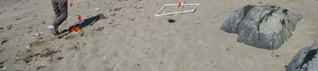
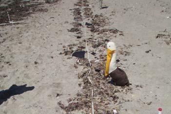
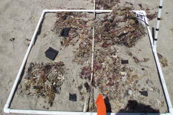
2 Shoreline Field Deployments Test Targets Bird Mimics Oil Mimics 2


3 Puma Image at ~300 ft Georeferenced Base Layer & COP Integration 3


4 Off Shore Deployments Distance Calculations/ Annotations Practical Deployment & Reality 4
5 Process / Timeline Wanted to test deployment during real event due to prior UAS demos Trustees agreed due to hard to access areas of shoreline & potential wildlife impacts UAS images could be useful for damage assessment Response (SSC/ USCG) did not see an operational need OAR/ NMS supportive of deployment with vessel and staffing capacity NRDA had priority concerns relative to core ephemeral data collection and data in-take needs Deliverables requested: Implementation Geo Tiffs stills ready for input into ERMA within 30 minutes of a shore-based flight landing Derived products (mosaics, stitching, etc.) available within 4-6 hours of a flight landing Copies of data for potential litigation hold Logistics OAR coordinated with Aerovironment for all asset field needs NMS offered Vessel for off shore deployment Response Operations approval and Air Boss coordination requirements Effort Initially denied and only re-evaluated when former OR&R Staff rotated into the positon Manned air craft coordination was successful due to personal connections 5


6 Standard NOAA Puma Flown Covered broad area in single day ~180 Images 5 videos No live wildlife observed Could not spatially rectify outputs Resolution not adequate for operational need * Images not for public distribution due to on-going NRDA PUMA High Resolution Nadir Camera * Images not for public distribution due to on-going NRDA 6
7 Lessons Learned Process involved a HIGH degree of coordination for approvals FAA, FCC, NMFS Protected Resources, Managed Areas, Response ICS, and asset logistics UAS deployment while response air ops is occurring is likely NOT practical in the near term Delivery of high resolution geo-rectified images is the operational requirements for ARD Video is not a primary product need for ARD, but streaming video could help direct operations of other assets in future for the response Lessons Learned Post processing time is MUCH slower than operational need at moment Creation of contracting vehicle would be needed for future use and funded within appropriate ICS funding structure Weather induced limitations on UAS flights (winds, ice, fog) very similar to manned Further evaluation is needed regarding collection platforms and mission needs (e.g. sensor type, fixed winged vs. copters, etc.) and improved information flow 7


")

8 Next Steps: Outline Mission Requirements Survey Need Mission Type Tool & Application Output Overview Reconnaissance Pre planned flight of a large area Longer range flight time/ capacity Offshore capabilities Planned Flight paths Model input Night time operations for resources planning High resolution, geo referenced photomosaic covering a defined area of interest in short processed time Remote Shorelines Pre planned flight of a long stretch of shoreline with limited shore access. May include flight plan adjustments and/or additional, short ad hoc flights for spot checks. Boat based operation with teams using UAS w/live streaming video feed to vessels to guide SCAT/ NRDA teams to hot spots or areas of interest. Live streaming video feed to vessel to guide field teams to areas of interest. Sensitive Habitats Pre planned flight of a defined area (covering the entire marsh or GRP sensitive area) High resolution visual image/video. High resolution, geo referenced photomosaic covering a defined area of interest Haul Outs/ Pocket Beaches Short duration, low altitude, asneeded flight(s) of small, discrete areas restricted / not safely accessible by other means Daypack sized UAS launched by field team (or accompanying Technical Specialist) on site for short spot checks. Short video with associated trackline to accompany SCAT segment form & high resolutions still images for counts and species ID 10/27/ Future Deployments Health Assessments Image Recognition Tag/ Recapture / Counts Ephemeral Collections Habitat Delineation Arctic 8
Airborne Remote Sensing Component of Marine Debris Monitoring
 Airborne Remote Sensing Component of Marine Debris Monitoring Dr. Thomas H Mace Mace Geospatial, LLC Workshop on Mission Concepts for Marine Debris Sensing Honolulu, Hi, Jan 19 21, 2016 Multistage Remote
Shortened Settlement Cycle Industry Steering Committee charter
 Shortened Settlement Cycle Industry Steering Committee charter Date: September 10 th, 2014 www.ust2.com I. Purpose The Depository Trust and Clearing Corporation (DTCC), in consultation with the industry,
PDC Members. Charter Members. Technology & Honorary Members. There is clearly a cross over 5/31/2017
 UAS A Tool for Commercial and Government Application Partnership SCARC 2017 Charles Mondello Eagleview Stategist & President Property Drone Consortium 1 The PDC is a consortium among insurance carriers,
small Unmanned Aircraft Systems Arlington Police Department June 28, 2011
 suas small Unmanned Aircraft Systems Arlington Police Department June 28, 2011 1. Overview of APD suas program to date 2. Discuss the C.O.A. (FAA certificate of authorization to fly) and restrictions
UAV Program. What does it take to have a UAV Program Current Requirements Lemhi County UAV program
 UAV Program UAV Program What does it take to have a UAV Program Current Requirements Lemhi County UAV program What does it take to have a UAV program? Some Very Important Questions to Ask Before What type
Establishing a Risk-Based Separation Standard for Unmanned Aircraft Self Separation
 Establishing a Risk-Based Separation Standard for Unmanned Aircraft Self Separation Roland E. Weibel, Matthew W.M. Edwards, and Caroline S. Fernandes MIT Lincoln laboratory Surveillance Systems Group Ninth
UAS Overview IDOT s UAS Program
 Unmanned Aircraft Systems (UAS) UAS Overview IDOT s UAS Program Linda Schumm Bureau Chief Aviation Safety Linda.Schumm@Illinois.gov October 18, 2017 Bill Viste Project Coordinator William.Viste@Illinois.gov
Geographic Response Plan Map: EFL-40 ]^4011. ! Manatee [v NERR. National Park. Naval Facility. Piping Plover. Power Plant. Recreational Fishing
![Geographic Response Plan Map: EFL-40 ]^4011. ! Manatee [v NERR. National Park. Naval Facility. Piping Plover. Power Plant. Recreational Fishing](/thumbs/91/105050028.jpg "Geographic Response Plan Map: EFL-40 ]^4011. ! Manatee [v NERR. National Park. Naval Facility. Piping Plover. Power Plant. Recreational Fishing") 29 22'30"N 81 7'30"W!E(! EFL40-01 Basin Bulow Creek State Park Addison Blockhouse Historic State Park NRC - Ormond Beach Warehouse Equipment Site (ID JAX-E8) River Basin k k Marsh Aquatic Preserve!S( 200
29 22'30"N 81 7'30"W!E(! EFL40-01 Basin Bulow Creek State Park Addison Blockhouse Historic State Park NRC - Ormond Beach Warehouse Equipment Site (ID JAX-E8) River Basin k k Marsh Aquatic Preserve!S( 200
LOW DOWN ON THE HIGH UP: USING DRONES FOR LAND CONSERVATION
 LOW DOWN ON THE HIGH UP: USING DRONES FOR LAND CONSERVATION TEXAS LAND CONSERVATION CONFERENCE MARCH 3, 2017 STEPHEN RAMIREZ STEWARDSHIP DIRECTOR TEXAS LAND CONSERVANCY RAY RENNER, RPLS, PMP MANAGER OF
CORSIA SEMINAR 6. Capacity Building Needs and Next Steps
 CORSIA SEMINAR 6. Capacity Building Needs and Next Steps ICAO Secretariat Capacity Building Needs and Next Steps - Outline a) Timeline for CORSIA Implementation b) Assessing States Current Readiness and
Using UAVs for Aerial Mapping, Surveying and Photography
 Using UAVs for Aerial Mapping, Surveying and Photography Prepared for: Central Florida GIS Workshop 18 September 2013 Kevin Shortelle System Dynamics International, Inc kevinshortelle@bellsouth.net Presentation
ESA-EDA: Paving the Way for New UAS Capabilities in Europe
 ESA-EDA: Paving the Way for New UAS Capabilities in Europe Dr. Stefan Gustafsson, ESA Jens Fehler, EDA Noordwijk, 11 th 12 th May 2010 Integrated Application Promotion Earth Observation Telecommunication
AGAZINE DECEMBER 2015/JANUARY 2016
 M IDWEST FLYER AGAZINE DECEMBER 2015/JANUARY 2016 Published For & By The Midwest Aviation Community Since 1978 midwestflyer.com Unmanned Aircraft Systems Technology Creating New Perspectives That Will
Aeros 40D Sky Dragon. TYPE CERTIFIED BY: United States Federal Aviation Administration Civil Aviation Authorities: Europe and Asia
 Aeros 40D Sky Dragon The Aeros 40D Sky Dragon Airship The United States Federal Aviation Administration (FAA) Type Certified Aeros 40D Sky Dragon is the most advanced non rigid airship, incorporating innovative
What is a UAS (Drone)
") UAS KCSI Aerial Patrol KCSI is Based in Bakersfield CA Established in 1993 Operates in 15 States KCSI has over 20 fulltime pilots Currently fly: Over 40,000 miles of pipeline a month 700 hours of production
UAS KCSI Aerial Patrol KCSI is Based in Bakersfield CA Established in 1993 Operates in 15 States KCSI has over 20 fulltime pilots Currently fly: Over 40,000 miles of pipeline a month 700 hours of production
U.S. Forest Service Explores Use of UAS In Fire Management Jennifer Jones Public Affairs Specialist Washington Office, Fire and Aviation Management
 U.S. Forest Service Explores Use of UAS In Fire Management Jennifer Jones Public Affairs Specialist Washington Office, Fire and Aviation Management On August 27, 2013, an unusual resource order was placed
Lone Star UAS Center. of Excellence and Innovation
 Lone Star UAS Center LSUASC Introduction of Excellence and Innovation Bringing UAS to America s Skies NASAO 85 th Annual Convention and Tradeshow UAS Emerging Technologies & Utilizations September 13,
Development and Testing of an Unmanned Aircraft Safety Beacon for Aerial Application Safety
 Development and Testing of an Unmanned Aircraft Safety Beacon for Aerial Application Safety Wayne Woldt, Ph.D., P.E., and Jacob Smith Biological Systems Engineering and School of Natural Resources University
Unmanned Aerial Vehicles for Environmental Applications
 Unmanned Aerial Vehicles for Environmental Applications John Rankin, President, J.R. Canadian Mapping Ltd. 10 th Annual Professional Biology Conference April 23 rd, 2015 UAVs Our System Suitable Sites
LAUNCHING YOUR UNMANNED AIRCRAFT PROGRAM
 LAUNCHING YOUR UNMANNED AIRCRAFT PROGRAM THE DARTDRONES TEAM UNMANNED AIRCRAFT APPLICATIONS AERIAL INSPECTIONS AERIAL INSPECTIONS Safer and faster alternative to visual inspection by an individual Damage
 Presented by: Lt. Michael J. Magda Team Leader, Firefighter, EMT -P, Hazardous Material Specialist, Private Pilot, Airframe & Power plant Mechanic Western Wayne County HMRT, Livonia Fire & Rescue And
Drones in Construction: Beyond Pictures Capturing and Exploring Actionable Data
 Drones in Construction: Beyond Pictures Capturing and Exploring Actionable Data Hunter Cole & Jesse Creech Virtual Design + Construction Brasfield & Gorrie General Contractors Join the conversation #AU2016
UAV Flight Services Company. What We Do. What Sets us Apart
 UAV Flight Services Company A dedicated team of aviators, technologists, and engineers. What We Do UAV flight services for data collection, mapping, and inspection What Sets us Apart Extensive field experience,
Engineering With Nature Geographic Project Mapping Tool (EWN ProMap)
") Engineering With Nature Geographic Project Mapping Tool (EWN ProMap) Cynthia Banks Program Manager Burton Suedel, PhD Research Biologist Michelle Bourne Research Biologist U.S. Army ERDC 23 June 2015 Dredging
Engineering With Nature Geographic Project Mapping Tool (EWN ProMap) Cynthia Banks Program Manager Burton Suedel, PhD Research Biologist Michelle Bourne Research Biologist U.S. Army ERDC 23 June 2015 Dredging
Adventures in UAS: Experiences of a UAS Operator. Paul Beckwith, PE, CCM, LEED AP bd+c Navigator CS, LLC, President. Presented by:
 Adventures in UAS: Experiences of a UAS Operator Presented by: Paul Beckwith, PE, CCM, LEED AP bd+c Navigator CS, LLC, President Paul Beckwith, PE, CCM, LEED AP bd+c BA in Architectural Engineering from
Roadmapping Breakout Session Overview
 Roadmapping Breakout Session Overview Ken Goodrich October 22, 2015 Definition Roadmap: a specialized type of strategic plan that outlines activities an organization can undertake over specified time frames
5 Day Operator Course. 1.0 AIRSPACE CLASSROOM ONLINE EXECUTIVE VO Terms X X Classification
 5 Day Operator Course 2 Day Executive Training 2 Day VO Training 0.1 INTRODUCTION CLASSROOM ONLINE EECUTIVE VO About Avion Solutions Purpose of the course Learning objectives Course outline and schedule
IAC 2011 Cape Town, October th
 Cape Town, October 05 05 th Project Partners External Supporters and Sponsors The Problem The Solution Overview S 2 BAS Concept of Operations Architecture Possible Applications Stakeholders Flight Phases
The Skyward Platform Helps You Manage UAV Operations
 The Skyward Platform Helps You Manage UAV Operations About Skyward Skyward s cloud-based UAV management platform powers scalable, efficient, safe, and insurable UAV operations for small businesses and
California State University Long Beach Policy on Unmanned Aircraft Systems
 California State University, Long Beach June 14, 2016 Policy Statement: 16-04 California State University Long Beach Policy on Unmanned Aircraft Systems The following policy statement was recommended by
Technologies for Autonomous Operations of UAVs
 Technologies for Autonomous Operations of UAVs TAKE OFF Conference Unmanned Aircraft Systems Towards Civil Applications 10. November 2009, Graz/Austria EADS 2009 All rights reserved Technologies for Autonomous
Unmanned Aircraft Systems (UAS) at the Jornada Experimental Range
 at the Jornada Experimental Range") Unmanned Aircraft Systems (UAS) at the Jornada Experimental Range Al Rango and the Jornada UAS Flight Team: Connie Maxwell, Amy Slaughter, Andrea Laliberte, Chris Pierce, Dave Thatcher, Jim Lenz, and Craig
Unmanned Aircraft Systems (UAS) at the Jornada Experimental Range Al Rango and the Jornada UAS Flight Team: Connie Maxwell, Amy Slaughter, Andrea Laliberte, Chris Pierce, Dave Thatcher, Jim Lenz, and Craig
New issues raised on collision avoidance by the introduction of remotely piloted aircraft (RPA) in the ATM system
 in the ATM system") New issues raised on collision avoidance by the introduction of remotely piloted aircraft (RPA) in the ATM system Jean-Marc Loscos DSNA expert on collision avoidance and airborne surveillance EIWAC 2013
New issues raised on collision avoidance by the introduction of remotely piloted aircraft (RPA) in the ATM system Jean-Marc Loscos DSNA expert on collision avoidance and airborne surveillance EIWAC 2013
PBN and RNAV concepts
 PBN and RNAV concepts Rabat, 16/27-03-2015 Target: Learn basic concept on PBN and RNAV. NOT FOR COMMERCIAL PURPOSES 2 Concepts Part 1: PBN concept Part 2: RNAV, RNP Part 3: FTE (Flight Technical Error)
DEVELOPING AN ECOSYSTEM FOR UAS SAFETY 2017 WHITEPAPER SERIES
 DEVELOPING AN ECOSYSTEM FOR UAS SAFETY 2017 1 THE ADDITION OF UNMANNED AIRCRAFT SYSTEMS (UAS) TO A CORPORATE FLIGHT DEPARTMENT The use of Unmanned Aircraft Systems (UAS) is becoming popular for varying
Unmanned Aircraft Systems
 Unmanned Aircraft Systems Airport Operations Update Presented to: Wisconsin Airport Managers By: Kevin Morris, Date: April 25, 2017 Overview A Few Reminders UAS Registration Myths vs Facts FAA Recognized
Rockwell Collins flight test plans
 Rockwell Collins flight test plans Information about flight operations to Brutus for weather radar flight data collection. June 21, 2016 update Richard Jinkins (319-310-2169 cell) Richard Rademaker (319-431-5489
ALASKA RRT. Arctic & Western Alaska Area Committee Brief March 5, 2019
 ALASKA RRT Arctic & Western Alaska Area Committee Brief March 5, 2019 AREA COMMITTEE UPDATE Notable Events within Area Committee: 5 Subcommittees met and began work on OSC tasking Workgroups formed underneath
SESSION 1: Q&A summary of session with Will Apps (Head of Energy Development) and Helen Elphick (Senior Development Manager)
 and Helen Elphick (Senior Development Manager)") Meeting Potential new offshore wind leasing - industry event: Q&A summary Date/time Wednesday 25 July 2018 Venue Glaziers Hall, 9 Montague Close, London Bridge, SE1 9DD Chair Presenters Clare Collard,
Meeting Potential new offshore wind leasing - industry event: Q&A summary Date/time Wednesday 25 July 2018 Venue Glaziers Hall, 9 Montague Close, London Bridge, SE1 9DD Chair Presenters Clare Collard,
SEARCH AND RESCUE OPERATIONAL SUPPORT AND LIMITATIONS
 Working Document of the NPC Study: Arctic Potential: Realizing the Promise of U.S. Arctic Oil and Gas Resources Made Available March 27, 2015 Paper #7-6 SEARCH AND RESCUE OPERATIONAL SUPPORT AND LIMITATIONS
Outline Why CCSU PinnaclX and Eversource
 CBIA 2018 Safety & Health Conference Wednesday, May 23, 2018 The Red Lion Hotel Cromwell 100 Berlin Road, Cromwell, CT Drones & Safety: A Brave New World Alfred A. Gates, Ph.D. CFI Helicopter, UAS Remote
Why Ohio? Research and Development: Test Infrastructure: Expertise and Workforce:
 Ohio UAS Center Strategic Plan 2019 Why Ohio? Ohio has a rich history of aviation going back to the days when the Wright Brothers first pioneered flight in 1903. Today, Ohio remains a national leader in
AIRCRAFT CHARTERS FOR THE OIL AND GAS INDUSTRY
 AIRCRAFT CHARTERS FOR THE OIL AND GAS INDUSTRY Contents Company overview Our oil and gas experience Unique service and expertise Commercial aircraft Falkland Islands: case study Cargo aircraft Tanzania:
Surveillance and Broadcast Services
 Surveillance and Broadcast Services Benefits Analysis Overview August 2007 Final Investment Decision Baseline January 3, 2012 Program Status: Investment Decisions September 9, 2005 initial investment decision:
Trajectory Based Operations
 Trajectory Based Operations Far-Term Concept Proposed Trade-Space Activities Environmental Working Group Operations Standing Committee July 29, 2009 Rose.Ashford@nasa.gov Purpose for this Presentation
The role of Unmanned Aircraft System (AUS) in search and rescue (SAR) operations
 in search and rescue (SAR) operations") The role of Unmanned Aircraft System (AUS) in search and rescue (SAR) operations Captain: Abdelkhalik Kamaleldin Soliman Selmy College of Maritime Transport & Technology Arab Academy for Science, Technology
The role of Unmanned Aircraft System (AUS) in search and rescue (SAR) operations Captain: Abdelkhalik Kamaleldin Soliman Selmy College of Maritime Transport & Technology Arab Academy for Science, Technology
Integrated Applications Programme (IAP) & Space for UAS UAS for Applications
 & Space for UAS UAS for Applications") ESA s Integrated Applications Programme (IAP) & Space for UAS UAS for Applications M. Vaissiere ESA Director of Telecommunications and Integrated Applications Programme European High Level UAS Conference
ESA s Integrated Applications Programme (IAP) & Space for UAS UAS for Applications M. Vaissiere ESA Director of Telecommunications and Integrated Applications Programme European High Level UAS Conference
SYLLABUS INTRODUCTION TO ROTARY WING FLYING QUALITIES AND PERFORMANCE
 22783 Cedar Point Road, Building 2168 Patuxent River, MD 20670 Phone: 301 757 5049 301 757 2731 Fax: 301 342 5003 www.navair.navy.mil/nawcad/usntps SYLLABUS INTRODUCTION TO ROTARY WING FLYING QUALITIES
Daisy Dean Trail 628/619 ATV Trail Construction
 Background and Purpose and Need The Daisy Dean ATV Trail Construction Project is located in the Little Belt Mountains, Musselshell Ranger District, Lewis and Clark National Forest approximately 32 miles
ADS-B Rule and Installation Guidance
 ADS-B Rule and Installation Guidance Presented by: Don Walker Date: June 2011 Outline U.S. ADS-B Rulemaking Airspace Rule Rule performance requirements AC 20-165 Installation and airworthiness approval
Space Based ADS-B. ICAO SAT meeting - June 2016 AIREON LLC PROPRIETARY INFORMATION
 Space Based ADS-B ICAO SAT meeting - June 2016 1 Options to Detect an Aircraft Position Position Accuracy / Update Interval Voice Position Reporting ADS-C Position Reporting Radar Surveillance / MLAT Space
ERIE ATCT STANDARD OPERATING PROCEDURES
 ORDER ERI ATCT 7110.10I ERIE ATCT STANDARD OPERATING PROCEDURES August 1, 2014 VATUSA CLEVELAND ARTCC VIRTUAL AIR TRAFFIC SIMULATION NETWORK VIRTUAL AIR TRAFFIC SIMULATE NETWORK UNITED STATES DIVISION
TERMS OF REFERENCE. Drone Advisory Committee (DAC) Role Name or Title Organization. Director, UAS Integration Office. Director, UAS Integration Office
 Role Name or Title Organization. Director, UAS Integration Office. Director, UAS Integration Office") TERMS OF REFERENCE Drone Advisory Committee (DAC) Committee Leadership Role Name or Title Organization Chairman Lead Designated Federal Officer Subcommittee Oversight Oversight Brian Krzanich Administrator
TERMS OF REFERENCE Drone Advisory Committee (DAC) Committee Leadership Role Name or Title Organization Chairman Lead Designated Federal Officer Subcommittee Oversight Oversight Brian Krzanich Administrator
PRO LINE FUSION UPGRADE FOR YOUR CITATION CJ3. Your all-in-one approach for airspace modernization and situational awareness.
 PRO LINE FUSION UPGRADE FOR YOUR CITATION CJ3 Your all-in-one approach for airspace modernization and situational awareness. A fully loaded package of baseline features that enable enviable options ADS-B
UAS to GIS Utilizing a low-cost Unmanned Aerial System (UAS) for Coastal Erosion Monitoring
 for Coastal Erosion Monitoring") UAS to GIS Utilizing a low-cost Unmanned Aerial System (UAS) for Coastal Erosion Monitoring Agenda Scope of today s presentation Demonstration Objectives Wrightsville Beach Test Area Masonboro Inlet Jetties
UAS to GIS Utilizing a low-cost Unmanned Aerial System (UAS) for Coastal Erosion Monitoring Agenda Scope of today s presentation Demonstration Objectives Wrightsville Beach Test Area Masonboro Inlet Jetties
UNMANNED AIRCRAFT SYSTEMS (UAS) IN UTILITIES
 IN UTILITIES") UNMANNED AIRCRAFT SYSTEMS (UAS) IN UTILITIES Presented by: Dan Carbone Avion Unmanned Why Drones? Why Drones? Cost Effective Entire cost of a UAS program can be recouped in first-year man-hour savings
UNMANNED AIRCRAFT SYSTEMS (UAS) IN UTILITIES Presented by: Dan Carbone Avion Unmanned Why Drones? Why Drones? Cost Effective Entire cost of a UAS program can be recouped in first-year man-hour savings
Drones, Robots and Public Safety
 Drones, Robots and Public Safety IWCE Thursday, March 30, 2017 11:30 am - 12:45 pm Room: S230 Session Number: TH12 The member organizations of the National Public Safety Telecommunications Council are
Performance Analysis of Space-Based ADS-B
 Performance Analysis of Space-Based ADS-B MIT Lincoln Labs ATC Workshop December 5 th, 2017 Dr. Michael Garcia and John Dolan 1 Agenda Aireon Overview On-Orbit Acceptance Test (OOAT) Performance Results
UAS Integration Activities
 UAS Integration Activities Presented to: Presented by: Ian Ross Senior Representative/Attaché Date: Meeting the Challenge Industry Volume & Pace Personal Nature of UAS Shared Commitment to Safety The Path
ANNUAL REPORT
 ANNUAL REPORT 2014-15 The Marine National Facility is owned and operated by CSIRO on behalf of the nation. DECEMBER 2015a CONTENTS About the Marine National Facility 1 Our Mission 2 Message from the Chairman
Unmanned Aircraft Systems (UAS) 101
 101") Unmanned Aircraft Systems (UAS) 101 Presented to: AUVSI Cascade Chapter Future Robotics Forum Presented by: Michael Dement-Myers, (FAA), NextGen Branch Date: October 20, 2016 Overview Unmanned Aircraft
Unmanned Aircraft Systems (UAS) 101 Presented to: AUVSI Cascade Chapter Future Robotics Forum Presented by: Michael Dement-Myers, (FAA), NextGen Branch Date: October 20, 2016 Overview Unmanned Aircraft
November 6, The Honorable Michael P. Huerta Administrator Federal Aviation Administration 800 Independence Avenue, SW Washington, DC 20591
 November 6, 2015 The Honorable Michael P. Huerta Administrator Federal Aviation Administration 800 Independence Avenue, SW Washington, DC 20591 RE: Clarification of the Applicability of Aircraft Registration
% farmers/private landowners in watershed applying BMPs. Other (Number of participants completed the training)
") Easygrants ID: 23803 National Fish and Wildlife Foundation NFWF/Legacy Grant Project ID: 0302.10.023803 U. S. Coral Reef Task Force Partnership Initiative 2010 - Submit Final Programmatic Report (Activities
Easygrants ID: 23803 National Fish and Wildlife Foundation NFWF/Legacy Grant Project ID: 0302.10.023803 U. S. Coral Reef Task Force Partnership Initiative 2010 - Submit Final Programmatic Report (Activities
Lesson 5: Campus Debris Survey
 Lesson 5: Campus Debris Survey Lesson 5 Presentation Content Engage Explore Explain Elaborate Evaluate Litter and Albatross Litter on Our Campus Analyzing Results Our Litter and Albatross Spreading the
Aerial Photography and Flight Planning
 Aerial Photography and Flight Planning What is VFR? Flight is to take place using visual references Must avoid clouds Normally have a distinguishable horizon Should have sight of the ground below, or in
TANZANIA CIVIL AVIATION AUTHORITY AIR NAVIGATION SERVICES INSPECTORATE. Title: CONSTRUCTION OF VISUAL AND INSTRUMENT FLIGHT PROCEDURES
 Page 1 of 8 1. PURPOSE 1.1. This Advisory Circular provides guidance to personnel involved in construction of instrument and visual flight procedures for publication in the Aeronautical Information Publication.
Unmanned Aircraft Systems (UAS) 101
 101") Unmanned Aircraft Systems (UAS) 101 Presented to: ACC Airports Technical Workshop Presented by: David Russell, Program Analyst, UAS Integration Office, Date: August 10, 2016 Overview Unmanned Aircraft
Unmanned Aircraft Systems (UAS) 101 Presented to: ACC Airports Technical Workshop Presented by: David Russell, Program Analyst, UAS Integration Office, Date: August 10, 2016 Overview Unmanned Aircraft
UNMANNED AERIAL SYSTEMS & THE AIRPORT SPONSOR
 UNMANNED AERIAL SYSTEMS & THE AIRPORT SPONSOR The Current Regulatory Framework And Practical Considerations May 7, 2016 Eric T. Smith Partner, Kaplan Kirsch & Rockwell Jonathan Cross Manager, Airport Law
Launching a New Surveying Perspective
 Launching a New Surveying Perspective >> By Mary Jo Wagner A 3 km2 orthomosaic shows the entire construction site and surroundings. On the upper part of the mosaic are the Bristol Channel; the existing
EXAMPLE FLIGHT PLAN. Project Information UBC PRODUCTIONS APEX^ZERO. Prepared for: Paul Hodges Vice President, SFG Productions
 UBC PRODUCTIONS APEX^ZERO FLIGHT PLAN EXAMPLE Project Information Prepared for: Paul Hodges Vice President, SFG Productions Prepared by: Roger Apolinar & Eric Carpenter Remote Pilots in Command, APEX^ZERO
UAV/Drone Uses and Laws
 UAV/Drone Uses and Laws Robert Moorhead Director of Geosystems Research and Northern Gulf Institutes Professor of Electrical & Computer Engineering Unmanned Aerial Systems (UASs) 3 components to the system:
Unmanned Aircraft Systems (UAS): A Paradigm Shift in Aviation
: A Paradigm Shift in Aviation") Unmanned Aircraft Systems (UAS): A Paradigm Shift in Aviation Tom Haritos, Ed.S. Department of Aeronautical Science Embry-Riddle Aeronautical University Florida Airports Council (FAC) 2015 1 The trouble
Unmanned Aircraft Systems (UAS): A Paradigm Shift in Aviation Tom Haritos, Ed.S. Department of Aeronautical Science Embry-Riddle Aeronautical University Florida Airports Council (FAC) 2015 1 The trouble
In-field and Remote Sensing for Precision Agriculture. John Nowatzki Extension Ag Machine Systems Specialist North Dakota State University
 In-field and Remote Sensing for Precision Agriculture John Nowatzki Extension Ag Machine Systems Specialist North Dakota State University UAS in Precision Agriculture In-field Sensors Selecting UAS Equipment
Flight Inspection for High Elevation Airports
 Flight Inspection for High Elevation Airports Mr. Pan Yi Director Flight Inspection Center of CAAC 23#, Tianzhu Road, Tianzhu Airport Industry Zone, Capital International Airport, Beijing, People s Republic
Definitions. U-SAFE : UAS Secure Autonomous Flight Environment. UTM: UAS Traffic Management
 Definitions U-SAFE : UAS Secure Autonomous Flight Environment UTM: UAS Traffic Management NUSTAR: National UAS Standardized Test and Rating 2 U-SAFE Award Dec 11, 2015 Signature Initiative in Central New
RUNWAY SAFETY GO-TEAM METHODOLOGY
 RUNWAY SAFETY GO-TEAM METHODOLOGY INTRODUCTION The ICAO Runway Safety Programme (RSP) promotes the establishment of Runway Safety Teams (RSTs) at airports as an effective means to reduce runway related
Air Law. Iain Darby NAPC/PH-NSIL IAEA. International Atomic Energy Agency
 Air Law Iain Darby NAPC/PH-NSIL International Atomic Energy Agency Aviation Regulations International Civil Aviation Organisation (ICAO) Convention on International Civil Aviation also known as the Chicago
Scientific Committee for Oceanographic Aircraft Research
 Scientific Committee for Oceanographic Aircraft Research United States Antarctic Program (USAP) Approach to Approving UAS/UAV Operations 28-29 June 2016 Tim McGovern, Ocean Projects Manager Division of
OWEA Woolpert UAS Operations
 OWEA 2016 Woolpert UAS Operations UAS Rules and Regulations How Woolpert is Handling This The Exemption In December 2014 Woolpert received approval from the FAA regarding an exemption seeking relief from
Marine/Offshore Industry Conference. Bristow Group Inc. March 29, 2012
 Marine/Offshore Industry Conference Bristow Group Inc. March 29, 2012 Bristow is the leading provider of helicopter transportation services to the global offshore industry Bristow flies crews and light
Key. Cotswold Water Park
 Existing Key Nature Sites Core Biodiversity Corridor Proposed Canals Biodiversity Scope The development of the CWP will be orientated towards meeting and exceeding biodiversity targets, making the CWP
How Frasca Supports Offshore Helicopter Pilot Training At Bristow Group
 How Frasca Supports Offshore Helicopter Pilot Training At Bristow Group Customer Feature Bristow Group Needed a New Training Solution In the mid-2000s, Bristow Group s training needs analysis identified
NOAA UAS Alaska/Arctic Flight Operations NOAA Office of Marine and Aviation Operations (OMAO) CAPT Philip Hall, OMAO
 CAPT Philip Hall, OMAO") NOAA UAS Alaska/Arctic Flight Operations NOAA Office of Marine and Aviation Operations (OMAO) CAPT Philip Hall, OMAO Overview NOAA s Ship and Aircraft Fleet UAS Operations Arctic Focus AeroVironment Puma
NOAA UAS Alaska/Arctic Flight Operations NOAA Office of Marine and Aviation Operations (OMAO) CAPT Philip Hall, OMAO Overview NOAA s Ship and Aircraft Fleet UAS Operations Arctic Focus AeroVironment Puma
Unmanned Aircraft Systems (UAS)
") Unmanned Aircraft Systems (UAS) Update Presented to: Airports Council International Presented by: Danielle J. Rinsler, AICP Date: Who is Operating UAS in the National Airspace System (NAS)?* Public (Governmental)
Unmanned Aircraft Systems (UAS) Update Presented to: Airports Council International Presented by: Danielle J. Rinsler, AICP Date: Who is Operating UAS in the National Airspace System (NAS)?* Public (Governmental)
Key Purpose & Need Issues
 Key Purpose & Need Issues Efficiently meet demand through the 2025 planning horizon 864,000+ annual operations 180-200 operations during peak daytime hours Balance peak hour arrival/departure capability
Safety Enhancement RNAV Safe Operating and Design Practices for STARs and RNAV Departures
 Safety Enhancement Action: Implementers: Statement of Work: Safety Enhancement 213.5 RNAV Safe Operating and Design Practices for STARs and RNAV Departures To mitigate errors on Standard Terminal Arrival
Safety Enhancement SE ASA Design Virtual Day-VMC Displays
 Safety Enhancement SE 200.2 ASA Design Virtual Day-VMC Displays Safety Enhancement Action: Implementers: (Select all that apply) Statement of Work: Manufacturers develop and implement virtual day-visual
July 29-30, 2010 Washington, D.C Procurement Agencies. Coast Guard Agencies
 2010 Military, Civilian and Commercial UAV Systems & Applications Unmanned Aircraft Systems Defense and Tactics Conference & Expo July 29-30, 2010 Washington, D.C Photo credit: US DoD 25 Countries 40 Procurement
Review of USAFA UAS Research
 HQ U.S. Air Force Academy Review of USAFA UAS Research Mr Ryan Osteroos, PE DFAN UAS Researcher USAFA Research Focus Our mission: Develop Officers of Character Cadet Based Learning Continuous research
Noise Abatement 101. July 13, Regular Board Meeting / August 7, 2014 Hillsborough County Aviation Authority
 Noise Abatement 101 July 13, 2017 1 Objectives Provide context and a better understanding for how and why flights may operate at Tampa International Airport the way they do. Provide an overview of laws,
Surveillance and. Program Status. Federal Aviation Administration Broadcast Services. To: By:
 Surveillance and Broadcast Services Program Status To: By: Date: International Helicopter Safety Team Jim Linney, Central Service Area Program Manager September 30, 2009 Background: Automatic Dependent
Hidalgo County Drone Program. Standard Operating Procedure (SOP) Template. February 23, 2017
 Template. February 23, 2017") Hidalgo County Drone Program Standard Operating Procedure (SOP) Template The following is a detailed (but intended as a comprehensive) framework of topics to be covered in a Standard Operating Procedure
Hidalgo County Drone Program Standard Operating Procedure (SOP) Template The following is a detailed (but intended as a comprehensive) framework of topics to be covered in a Standard Operating Procedure
January 14, Orange County Transportation Authority Attn: M2 NCCP/HCP 550 South Main Street P.O. Box Orange, CA
 Equestrian Trails, Inc. Corral 357 P.O. Box 1026 Trabuco Canyon, CA 92678 http://saddlebackcanyonriders.com/ President: James Iacono... 714-612-1789 January 14, 2016 Orange County Transportation Authority
BAe-146 Next Generation Airtanker Frequently Asked Questions. Q. Why do you have to download on retardant at some airtanker bases?
 BAe-146 Next Generation Airtanker Frequently Asked Questions Q. Why do you have to download on retardant at some airtanker bases? Density Altitudes affect all aircraft. During the fire season, it is not
New York Aviation Management Association Conference
 New York Aviation Management Association Conference Presented by: Carmine W. Gallo Federal Aviation Administration Eastern Region Regional Administrator September 14, 2016 1 The What is and Benefits of
What Is The Proposed 29Palms Training Land Acquisition and Airspace Establishment Project? Frequently Asked Questions Airspace Related June 2014
 MARINE CORPS / DEPARTMENT OF THE NAVY SUBMIT SPECIAL USE AIRSPACE PROPOSALS TO THE FEDERAL AVIATION ADMINISTRATION TO MEET MARINE EXPEDITIONARY BRIGADE TRAINING REQUIREMENTS 1. Why has the Marine Corps
Getting off the Ground: Implementing a Drone Program
 Getting off the Ground: Implementing a Drone Program November 2017 Steve Goldman, GISP GIS Manager / UAS Coordinator California Department of Fish and Wildlife http://www.wildlife.ca.gov Drones (UAS) What
April 16, Erik Larson
 April 16, 2018 Erik Larson Contributors: ACTA: Steve Carbon, John Herndon, Ron Lambert, Elliot Porterfield FAA: Phil Bassett, Kevin Hatton, Dan Murray, Paul Wilde Project funded by: Federal Aviation Administration
Cal UAS Portal. Eileen Shibley UAS Lead, Inyokern Airport
 Cal UAS Portal Eileen Shibley UAS Lead, Inyokern Airport eshibley@me.com 760-382-1049 Commercial Airline Traffic IYK *NASA Ames Image *NASA Ames Image R-2508 Complex Drone, UAV, UAS, RPV, RPA, Air Robot?
Safe UAS Integration Challenges Views and Concerns from the Airline Cockpit
 Safe UAS Integration Challenges Views and Concerns from the Airline Cockpit Presentation by the Air Line Pilots Association, International AGENDA Introduction/Bio UAS/RPAS Background/Discussion ALPA s