AGAZINE DECEMBER 2015/JANUARY 2016
|
|
|
- Beatrice Greer
- 5 years ago
- Views:
Transcription


1 M IDWEST FLYER AGAZINE DECEMBER 2015/JANUARY 2016 Published For & By The Midwest Aviation Community Since 1978 midwestflyer.com
 have to positively benefit our lives and change the way we look at the world.")


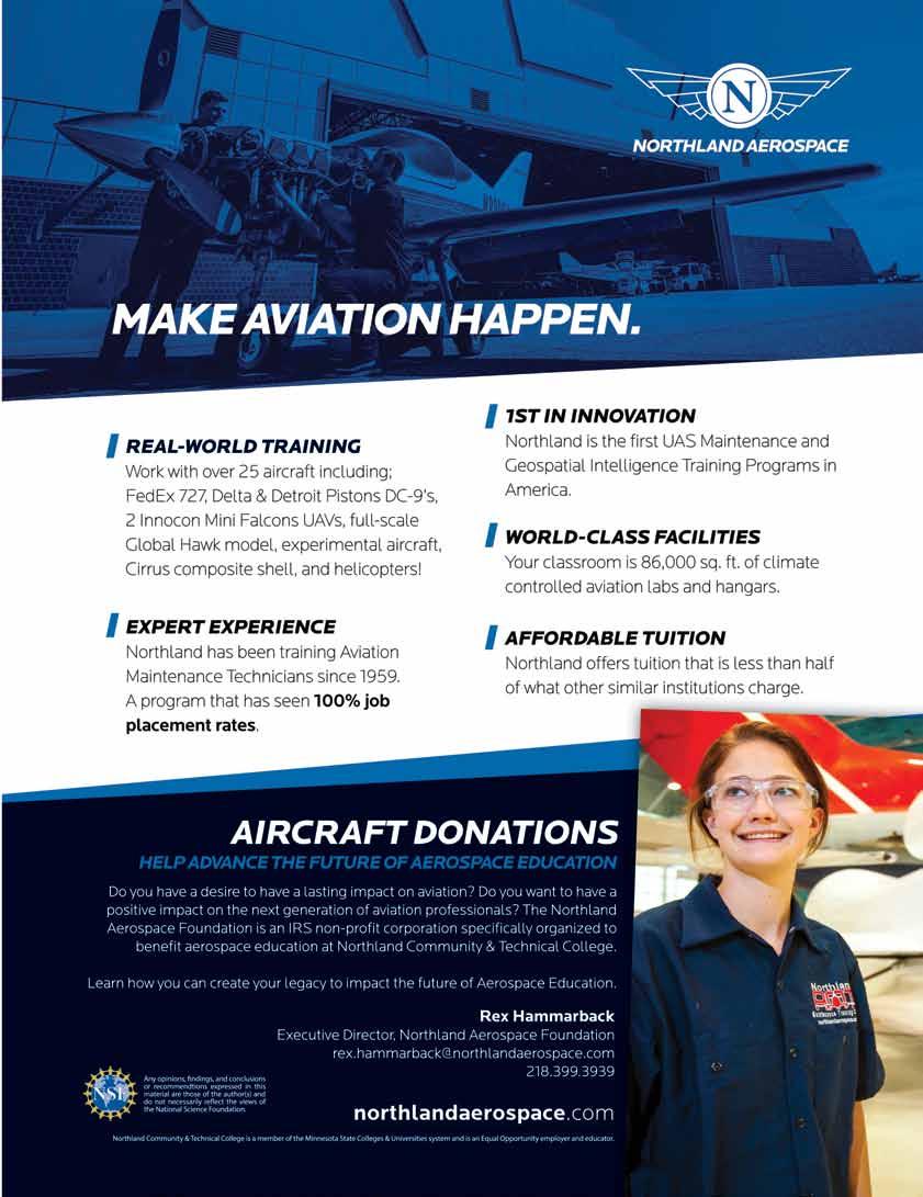
2 Unmanned Aircraft Systems Technology Creating New Perspectives That Will Open The Imagination of Future Generations by Jonathan Beck Imaginations fueled with fascination continue to explore the potential Unmanned Aircraft Systems (UAS) have to positively benefit our lives and change the way we look at the world. UAS are another contributor in the aviation community fostering excitement and intrigue, driving people s creativity, and inventions for new ways to utilize technology. UAS Jonathan Beck continue to be an exciting technology with broad impact to many disciplines. Although a small acronym, UAS are a very large topic raising hot debates across the county. Five years ago, headlines were filled with controversial stories about bringing military technology used overseas in war back to the United States and into the airspace overhead. This raised privacy concerns and fears of what else might accompany the use of UAS technology. In the last few years, there has been a dramatic shift with the emergence of small UAS for a wide range of civil applications, demonstrating the positive impact these systems offer for diverse industries and applications. Some of the most predominant industries impacted by the technology today include cinematography, agriculture, land survey and mapping, infrastructure inspection, logistics, and public safety. Although the positive benefits are being realized, the proliferation of small UAS has caused concerns with routine sighting of UAS in areas posing safety hazards. A key to advancing UAS technology safely will be the education of the technicians who operate and maintain UAS. Effective use of the technology will require technicians skilled at operating the systems for a wide range of demands including the processing and analysis of the imagery and data collected. Future technicians and entrepreneurs pursuing UAS technology must understand the differences in system interfaces and their correlation relating to specific tasks. There are many platforms with a wide range of options and accessories available based on how the operator intends to use the system. Two of the most well known manufacturers in the small UAS industry are DJI and 3D Robotics. The DJI Go application can be downloaded to a smart device and used with a DJI remote control for flying DJI UAS and to monitor and capture live video and imagery. DJI is an industry leader in small UAS and offers platforms that utilize an application that can be downloaded on iphones or other smart devices. The Go Pilot app provides a user-friendly interface the operator can use to monitor digital readouts for altitudes, distances, rate of change measurements and battery status. Operators are Visit Northland Community and Technical College at & Northland Aerospace at NCTC is an equal opportunity educator and employer. 54 DECEMBER 2015/JANUARY 2016 MIDWEST FLYER MAGAZINE
3

4 able to perform automatic flight modes with the click of a button for multiple functions including takeoff, GPS waypoint navigation, return to home point and landing. The application on the smart device, paired with the remote control, allows the operator the ability to maneuver the aircraft and the built-in camera sensor while monitoring the live video downlink. With the latest platforms, 4k-resolution video and 12 mega pixel still imagery can be captured. Imagery and data is stored onboard the aircraft, but it can also be seamlessly transferred to a smart device or a computer for further processing. 3D Robotics manufactures a number of systems compatible with typical remote control, but can also perform a variety of automated flight modes. Switches on the remotes can be programmed to perform functions of altitude hold, position hold, orbit a point or transfer control to a ground control station (GCS) computer. Once control is transferred to the GCS, the operator has a much more detailed view of the performance of the aircraft, along with control functions, such as preprogrammed flight plan navigation. Flight plans can be generated to perform specific patterns that may assist in collecting the desired imagery and data for specific applications. There are many do-it-yourself homebuilt UAS that provide a platform to install aftermarket parts and camera systems. These additions may or may not tie directly into the electronic control unit for the system. A common example of a stand alone after market add-on is to mount a Go-Pro camera system onto a UAS. The Go-Pro system allows the operator to start recording before the aircraft takes off and continues to record the whole time the aircraft is in flight. This might be good for cinematography as it offers a good solution to capture high-resolution video, but it requires additional data storage and post flight editing. Engineers continue to invent new designs and features to increase the capabilities of UAS. However, many manufacturers have also recognized hazards UAS can pose when operated in certain areas, such as airport environments, temporary flight restrictions (TFRs), or at distances and altitudes not allowing the operator to visually monitor the aircraft to perform see and avoid. As a result, many systems now employ geo-fencing defined boundaries in the control software that can be adjusted by the operator. A geo-fence is a boundary created using GPS technology that defines a specific area or distance including the altitude that the aircraft can fly from the operator. This provides a control zone or containment area that can be very useful and assist in situational awareness for operating UAS. Some manufacturers have gone so far as to build in restriction zones based on airports, airways and critical areas, such as TFRs. DJI has several UAS that incorporate a boundary within certain proximity of airports that will not allow the UAS to turn motors. If slightly outside the boundary area, the operator can fly up to 35 feet and then climb at a slant to 400 feet once 5 miles or greater from an 56 DECEMBER 2015/JANUARY 2016 MIDWEST FLYER MAGAZINE A typical flight plan, takeoff and landing setup for the ground control station software for operating Sentera's Phoenix UAS. airport. These implementations are not a perfect solution to prevent common safety hazards, but are a great step to continue advancing the technology, while acting as good stewards of the airspace. Over the past few years, after obtaining a Certificate of Authorization (COA) or Federal Aviation Administration (FAA) approval, Northland Community and Technical College has conducted extensive work using the Phoenix fixed-wing UAS manufactured by Minnesota-based company, Sentera LLC of Minneapolis. This system is flown completely off of a ground control station (GCS) computer. Operators must ensure proper input of preset information into the software driving the flight of the UAS. The operator always maintains the ability to manually control the aircraft at anytime. When information is properly inputted, the result will allow for many automated flight mode functions. The configuration of the Phoenix Northland uses is designed specifically around agriculture, but can also be modified based on application. The GCS allows a flight plan to be generated by simply clicking in the middle of a field on a software map for application in production agriculture. A square is generated to define the boundary and the operator can expand the edges to the outside boundaries of the field. Once the boundary is defined, a default flight plan is created consisting of parallel passes the aircraft will fly while capturing still images. If there is a crosswind at altitude, the autopilot turns the aircraft into the wind the necessary amount to compensate and maintain the preprogrammed flight path. The images are captured with a preset amount of overlap to be processed post flight for further evaluation. In the first year of Northland s UAS flight operations, a lot of images and data were collected and analyzed by growers, commodity associations and industry partners. The result was a Minnesota Department of Agriculture grant being awarded to Northland this past year based on the identification of a handful of field level practical applications for the technology. The title of the project is Digital Imagery, Precision Agriculture, with a goal to streamline the process of turning digital imagery into usable products that could be read and utilized by commercial applicator vehicles in farming. This

5 More than 500 images collected by the Phoenix UAS have been stitched together into one large mosaic image of the University of Minnesota Magnusson Research Farm in Roseau, Minnesota. requires applied research to create an efficient and effective use of the information collected using UAS technology. The Minnesota Department of Agriculture project has lead to an understanding of the necessary software tools, database management practices and processing techniques to develop the imagery and data collected for uses, such as identifying specific signatures for weeds and plant stress leading to prescriptions that can be utilized by applicator vehicles. Some of the tools include software to combine or stitch the multiple still images by correlating pixel points and geo-tags to make a mosaic or single image of a large section. Once a mosaic is created, it can be imported into a geographic information system tool and used for a wide range of applications, such as marking geo-reference areas, topography mapping, or identifying visual signatures of interest. The outputs of the project will lead to increased yield production, reduction of inputs, and greater environmental stewardship. Different applications will greatly change the operational concepts and safety considerations that UAS technicians need to take into account. For example, the collection of information to support production agriculture, infrastructure inspection and public safety will all require very different considerations for planning. Production agriculture provides a static environment, typically very little for obstacles and obstructions, and would most likely utilize a preset flight plan in which the UAS technician monitors systems to make sure they are functioning properly. Infrastructure inspection would most likely involve operating around obstructions and understanding the correct stand-off distance for both safety and capturing the desired information relevant to the application. Public safety requires a high level of safety considerations based on a dynamically changing situation on the ground and during flight. Each application requires a unique understanding of the end user requirements, as well as a comprehensive approach on how to employ UAS effectively, to produce the desired products while doing it safely. UAS technology is transforming aviation and the demands for future technician education. Northland is developing the necessary technician education programs to support these needs. This year, Northland was awarded a National Science Foundation (NSF) Advanced Technological Education (ATE) Project Grant (DUE ) to develop curriculum and pathways material for emerging careers in UAS technology. This coming summer, Northland will provide workshops for educators and summer camps for secondary students. These opportunities will provide access and create awareness of the potential UAS have and the impact they are creating. Six National UAS Test Sites are already leading the way on integration initiatives, but the initiative stretches beyond these boundaries and across the country. Now is the time to prepare by leveraging the expertise of aviation innovators who have led us to today to help write the pages of tomorrow. Relationships between education, government and industry partners are key to advance technician education, parallel to significant changes resulting from integration of UAS technology. A highly educated technician workforce will allow for safe and effective integration of UAS technology across a wide range of applications expanding beyond potential into actual transformation of our future. It will also allow for all stakeholders affected by the integration of UAS to advance with the technology, create opportunities, and expand careers in related disciplines. The results will open the doors to advance our knowledge about a technology creating new perspectives that have never existed. These perspectives will open the imagination of future generations, only limited by what we choose to explore. EDITOR S NOTE: This material is based in part upon work supported by the National Science Foundation (DUE ). Any opinions, findings, and conclusions or recommendations expressed in this material are those of the author(s) and do not necessarily reflect the views of the National Science Foundation. Jonathan Beck is the UAS Instructor/Program Manager at Northland Community & Technical College in Thief River Falls, Minnesota. q DECEMBER 2015/JANUARY 2016 MIDWEST FLYER MAGAZINE 57
Commit to Safety: Professional Pilots Always Use a Checklist INITIAL EQUIPMENT SETUP
 Commit to Safety: Professional Pilots Always Use a Checklist INITIAL EQUIPMENT SETUP READ THE MANUAL Familiarize yourself with all aspects of your suas before you even consider going out for your first
Menlo Park Fire District Training Division. Unmanned Aerial System Pilot
 Menlo Park Fire District Training Division TASK BOOK FOR THE POSITION OF Unmanned Aerial System Pilot Date Issued TASK BOOK ASSIGNED TO: Individuals name, assignment DATE TASK BOOK INITIATED The material
FLIGHT PATH FOR THE FUTURE OF MOBILITY
 FLIGHT PATH FOR THE FUTURE OF MOBILITY Building the flight path for the future of mobility takes more than imagination. Success relies on the proven ability to transform vision into reality for the betterment
What is a UAS (Drone)
") UAS KCSI Aerial Patrol KCSI is Based in Bakersfield CA Established in 1993 Operates in 15 States KCSI has over 20 fulltime pilots Currently fly: Over 40,000 miles of pipeline a month 700 hours of production
UAS KCSI Aerial Patrol KCSI is Based in Bakersfield CA Established in 1993 Operates in 15 States KCSI has over 20 fulltime pilots Currently fly: Over 40,000 miles of pipeline a month 700 hours of production
Why Ohio? Research and Development: Test Infrastructure: Expertise and Workforce:
 Ohio UAS Center Strategic Plan 2019 Why Ohio? Ohio has a rich history of aviation going back to the days when the Wright Brothers first pioneered flight in 1903. Today, Ohio remains a national leader in
LAUNCHING YOUR UNMANNED AIRCRAFT PROGRAM
 LAUNCHING YOUR UNMANNED AIRCRAFT PROGRAM THE DARTDRONES TEAM UNMANNED AIRCRAFT APPLICATIONS AERIAL INSPECTIONS AERIAL INSPECTIONS Safer and faster alternative to visual inspection by an individual Damage
Aviation Noise and Emissions Symposium February 27, 2018
 National Aeronautics and Space Administration Aviation Noise and Emissions Symposium February 27, 2018 Chuck Johnson Senior Advisor for UAS Integration on behalf of Dr. Parimal Kopardekar Senior Technologist
Advancing FTD technologies and the opportunity to the pilot training journey. L3 Proprietary
 Advancing FTD technologies and the opportunity to the pilot training journey L3 Proprietary Aviation Training Innovation Over the past decade the airline training industry has pursued technology to improve
Real-time route planning streamlines onboard operations, reduces fuel burn and delays, and improves on-time performance.
 Real-time route planning streamlines onboard operations, reduces fuel burn and delays, and improves on-time performance. Operational Efficiency of Dynamic Navigation Charting Benefits such as improved
Hidalgo County Drone Program. Standard Operating Procedure (SOP) Template. February 23, 2017
 Template. February 23, 2017") Hidalgo County Drone Program Standard Operating Procedure (SOP) Template The following is a detailed (but intended as a comprehensive) framework of topics to be covered in a Standard Operating Procedure
Hidalgo County Drone Program Standard Operating Procedure (SOP) Template The following is a detailed (but intended as a comprehensive) framework of topics to be covered in a Standard Operating Procedure
Fly at the speed of ingenuity on your Learjet 85
 rockwell collins Pro Line Fusion Avionics Fly at the speed of ingenuity on your Learjet 85 Image courtesy of Bombardier. Experience the most advanced avionics system ever offered on a mid-size jet. Achieve
Potential Uses and Considerations Regarding the Use of UAS Technology in Assessment. January 2015 Frank Giuffrida
 Potential Uses and Considerations Regarding the Use of UAS Technology in Assessment January 2015 Frank Giuffrida Table of Contents Current climate surrounding UAS use... 2 Assessing the value of properties
Unmanned Aircraft Systems Integration
 Unmanned Aircraft Systems Integration Advancing Autonomous Capabilities in the Artificial Intelligence/Cyber Domain Presented to: The Patuxent Partnership Presented by: Art Hinaman, Manager, Technical
AUGUST 2017 GNSS REVIEW. Survey Economics Chances of success. Mobile Mapping Airport scanning. Stag s Leap Winery Pre-construction plan
 AUGUST 2017 GNSS REVIEW Survey Economics Chances of success Stag s Leap Winery Pre-construction plan Mobile Mapping Airport scanning RISING PERFORMANCE» ERIK DAHLBERG Civil aviation is an outlier. It s
RISING PERFORMANCE. Civil aviation is an outlier. It s BY ERIK DAHLBERG
 RISING PERFORMANCE Compact mobile mapping systems can be installed on small passenger cars. Civil aviation is an outlier. It s among the few industries where tight government regulations are widely accepted
Sam Houston State University UAS Use Checklist
 Sam Houston State University UAS Use Checklist The FAA Part 107 of the Code of Federal Regulations and the Sam Houston State University President s Office Policy PRE-27 determine the minimum requirements
Hazard Identification Questionnaire
 Hazard Identification Questionnaire OVERVIEW This questionnaire is designed to help identify potential risks and help identify areas of risk exposure. It is not an exhaustive list. This questionnaire is
WELCOME TO THE AGE OF THE CONNECTED AIRCRAFT
 WELCOME TO THE AGE OF THE CONNECTED AIRCRAFT The Connected Aircraft Honeywell is changing the way people communicate on and with an aircraft today and in the future making the business of flying safer,
Jeppesen Total Navigation Solution
 Jeppesen Total Navigation Solution Executive summary Do more with less. It s a challenge we all face, and it s the reality of military operations. Jeppesen s Total Navigation Solution (TNS) gives you enterprise,
Unmanned Aircraft Operations in the National Airspace System. AGENCY: Federal Aviation Administration (FAA), DOT.
, DOT.") [4910-13] DEPARTMENT OF TRANSPORTATION Federal Aviation Administration 14 CFR Part 91 Docket No. FAA-2006-25714 Unmanned Aircraft Operations in the National Airspace System AGENCY: Federal Aviation Administration
[4910-13] DEPARTMENT OF TRANSPORTATION Federal Aviation Administration 14 CFR Part 91 Docket No. FAA-2006-25714 Unmanned Aircraft Operations in the National Airspace System AGENCY: Federal Aviation Administration
UNMANNED AIRCRAFT PROVISIONS IN FAA REAUTHORIZATION BILL
 UNMANNED AIRCRAFT PROVISIONS IN FAA REAUTHORIZATION BILL Section 341 Comprehensive Plan -Codifies in title 49 the requirement in the 2012 FAA reauthorization Act that a comprehensive plan to safely accelerate
The Freedom of Flight
 The Freedom of Flight Authors: Nicco Bugarin, Keith Kaplan and Wilhelm Cashen Date: May 20 2014 Safe Flight System The Commercialization of UAVS Safe Flight TM System is a Trademark of the Tesla Foundation
LOW DOWN ON THE HIGH UP: USING DRONES FOR LAND CONSERVATION
 LOW DOWN ON THE HIGH UP: USING DRONES FOR LAND CONSERVATION TEXAS LAND CONSERVATION CONFERENCE MARCH 3, 2017 STEPHEN RAMIREZ STEWARDSHIP DIRECTOR TEXAS LAND CONSERVANCY RAY RENNER, RPLS, PMP MANAGER OF
Lone Star UAS Center. of Excellence and Innovation
 Lone Star UAS Center LSUASC Introduction of Excellence and Innovation Bringing UAS to America s Skies NASAO 85 th Annual Convention and Tradeshow UAS Emerging Technologies & Utilizations September 13,
Testimony. of the. National Association of Mutual Insurance Companies. to the. United States House of Representatives
 Testimony of the National Association of Mutual Insurance Companies to the United States House of Representatives Committee on Small Business, Subcommittee on Investigations, Oversight and Regulations
UAS OPERATIONS AS AN ECOSYSTEM
 1 including photocopying, recording, or other electronic or mechanical methods, without the prior written permission of the content owner, The Unmanned Safety Institute, LLC. UAS OPERATIONS AS AN ECOSYSTEM
Operators may need to retrofit their airplanes to ensure existing fleets are properly equipped for RNP operations. aero quarterly qtr_04 11
 Operators may need to retrofit their airplanes to ensure existing fleets are properly equipped for RNP operations. 24 equipping a Fleet for required Navigation Performance required navigation performance
UAS Integration Activities
 UAS Integration Activities Presented to: Presented by: Ian Ross Senior Representative/Attaché Date: Meeting the Challenge Industry Volume & Pace Personal Nature of UAS Shared Commitment to Safety The Path
4.2 Regional Air Navigation/Safety Developments and Achievements. Group (NAM/CAR ANI/WG) INTEGRATION OF UNMANNED AIRCRAFT SYSTEMS (UAS)
 INTEGRATION OF UNMANNED AIRCRAFT SYSTEMS (UAS)") 03/05/16 Sixth Meeting of the North American, Central American and Caribbean Directors of Civil Aviation (NACC/DCA/06) Nassau, Bahamas, 10 12 May 2016 Agenda Item 4: Accountability Report of the ICAO NACC
03/05/16 Sixth Meeting of the North American, Central American and Caribbean Directors of Civil Aviation (NACC/DCA/06) Nassau, Bahamas, 10 12 May 2016 Agenda Item 4: Accountability Report of the ICAO NACC
SAFETY & AIRCRAFT OPERATIONS LEGISLATIVE & REGULATORY ADVOCACY NETWORKING & COMMERCE EDUCATION & CAREER DEVELOPMENT BUSINESS MANAGEMENT RESOURCES
 DEDICATED TO HELPING BUSINESS ACHIEVE ITS HIGHEST GOALS. NBAA RESOURCE Integrated Operational Management and Oversight for suas May 13, 2016 Disclaimer: This NBAA publication is intended to provide members
fll,' The University of Georgia O tfo:c o f rh.: Vu:.: Pre,id.:nt for Research
 November 30, 2015 fll,' - - - ----- I M.$------- The University of Georgia ------------------9 O tfo:c o f rh.: Vu:.: Pre,id.:nt for Research U.S. Department of Transportation Docket Management System
Subtitle B Unmanned Aircraft Systems
 H. R. 658 62 (e) USE OF DESIGNEES. The Administrator may use designees to carry out subsection (a) to the extent practicable in order to minimize the burdens on pilots. (f) REPORT TO CONGRESS. (1) IN GENERAL.
DEFINITIONS DEFINITIONS 2/11/2017 REQUIREMENTS AND LIMITATIONS OF DRONE USE IN FORENSIC ACCIDENT RECONSTRUCTION
 REQUIREMENTS AND LIMITATIONS OF DRONE USE IN FORENSIC ACCIDENT RECONSTRUCTION ROGER BURGMEIER BURGMEIER CONSULTING INC. DEFINITIONS Aircraft: device that is used, or intended to be used, for flight. Drone:
Airport Safety Management Systems: Integrating Planning Into the Process
 Airport Safety Management Systems: Integrating Planning Into the Process Kenneth Jacobs Senior Airport Planner FAA Airport Planning and Environmental Division ken.jacobs@faa.gov SMS Defined A process for
Enabling Civilian Low-Altitude Airspace and Unmanned Aerial System (UAS) Operations. Unmanned Aerial System Traffic Management (UTM)
 Operations. Unmanned Aerial System Traffic Management (UTM)") Enabling Civilian Low-Altitude Airspace and Unmanned Aerial System (UAS) Operations By Unmanned Aerial System Traffic Management (UTM) Parimal Kopardekar, Ph.D. UTM Principal Investigator and Manager,
Enabling Civilian Low-Altitude Airspace and Unmanned Aerial System (UAS) Operations By Unmanned Aerial System Traffic Management (UTM) Parimal Kopardekar, Ph.D. UTM Principal Investigator and Manager,
The next generation of in-flight, real-time 3-D moving maps. Airshow 4000 MOVING MAPS
 The next generation of in-flight, real-time 3-D moving maps. Airshow 4000 MOVING MAPS Stay engaged and aware in the air. In today s world, things happen faster than ever. You can t afford to be out of
DEVELOPING AN ECOSYSTEM FOR UAS SAFETY 2017 WHITEPAPER SERIES
 DEVELOPING AN ECOSYSTEM FOR UAS SAFETY 2017 1 THE ADDITION OF UNMANNED AIRCRAFT SYSTEMS (UAS) TO A CORPORATE FLIGHT DEPARTMENT The use of Unmanned Aircraft Systems (UAS) is becoming popular for varying
California State University Long Beach Policy on Unmanned Aircraft Systems
 California State University, Long Beach June 14, 2016 Policy Statement: 16-04 California State University Long Beach Policy on Unmanned Aircraft Systems The following policy statement was recommended by
5 Day Operator Course. 1.0 AIRSPACE CLASSROOM ONLINE EXECUTIVE VO Terms X X Classification
 5 Day Operator Course 2 Day Executive Training 2 Day VO Training 0.1 INTRODUCTION CLASSROOM ONLINE EECUTIVE VO About Avion Solutions Purpose of the course Learning objectives Course outline and schedule
Communications and Information Technology Alert
 Communications and Information Technology Alert Communications and Information Technology Alert: Drones and Urban Air Mobility in the President s Budget April 9, 2019 President Trump recently released
AUTOMATION MANAGEMENT STANDARD OPERATING PROCEDURES
 MANAGEMENT STANDARD OPERATING PROCEDURES University of Dubuque Table of Contents Practical Test Standards..3 Levels of Automation..4 Limitations...7 Flight Director.. 8 Operating Procedures..9 Callouts
Use this safety advisor as an aid in making the presolo written test an effective learning tool. Intructor s Guide. Instructor s Guide
 S A F E T Y A D V I S O R Training No. 1 Intructor s Guide Instructor s Guide To the Presolo Written Test To The Presolo Written Test Introduction This Safety Advisor is designed to assist flight instructors
PBN Operational Approval Continental En Route Navigation Specifications
 PBN Operational Approval Continental En Route Navigation Specifications Navigation Specifications Applicable to Continental En-route operations RNAV 5 RNAV 2 RNP 2 A-RNP RNP 0.3 2 RNAV 5 Flight Phase Navigation
OFWIM and DRONES How to stay out of trouble
 OFWIM and DRONES How to stay out of trouble AMA, FAA, and FARs FAA 2012 Reform and Modernization Act 2014 Interpretive Rule AMA 550 AMA 560 AC91-57 FAR 91.119 d1 NPRM Section 333 United States v. Causby328
UNITED STATES OF AMERICA DEPARTMENT OF TRANSPORTATION FEDERAL AVIATION ADMINISTRATION WASHINGTON, DC
 UNITED STATES OF AMERICA DEPARTMENT OF TRANSPORTATION FEDERAL AVIATION ADMINISTRATION WASHINGTON, DC Regulatory Docket No. FAA-2007-3330-0001 IN THE MATTER OF THE PETITION FOR EXEMPTION OF: STEVEN MCDONALD
ANSI Unmanned Aircraft Systems Standardization Collaborative (UASSC) Kick-off Meeting. 28 September 2017 (updated 4 October)
 Kick-off Meeting. 28 September 2017 (updated 4 October)") ANSI Unmanned Aircraft Systems Standardization Collaborative (UASSC) Kick-off Meeting 28 September 2017 (updated 4 October) Welcome and Opening Remarks American National Standards Institute (ANSI) Joe
ANSI Unmanned Aircraft Systems Standardization Collaborative (UASSC) Kick-off Meeting 28 September 2017 (updated 4 October) Welcome and Opening Remarks American National Standards Institute (ANSI) Joe
Drone Technology: What Works for Industry & Landowners. Michael J. Buschermohle Interim Assistant Dean UT Extension
 Drone Technology: What Works for Industry & Landowners Michael J. Buschermohle Interim Assistant Dean UT Extension So You Want to Fly FAA Regulations UAS Platforms Cameras Applications in Forestry Current
DRONES + AIRPORTS: BUZZ AROUND HARTSFIELD-JACKSON
 DRONES + AIRPORTS: BUZZ AROUND HARTSFIELD-JACKSON ACI-NA Legal Affairs Spring Conference Elizabeth Wharton, Senior Asst. City Attorney elizabeth.wharton@atl.com ATL Activities UAS Part 107 Operations contractors,
ultimate traffic Live User Guide
 ultimate traffic Live User Guide Welcome to ultimate traffic Live This manual has been prepared to aid you in learning about utlive. ultimate traffic Live is an AI traffic generation and management program
Outline Why CCSU PinnaclX and Eversource
 CBIA 2018 Safety & Health Conference Wednesday, May 23, 2018 The Red Lion Hotel Cromwell 100 Berlin Road, Cromwell, CT Drones & Safety: A Brave New World Alfred A. Gates, Ph.D. CFI Helicopter, UAS Remote
Appendix C AIRPORT LAYOUT PLANS
 Appendix C AIRPORT LAYOUT PLANS Appendix C AIRPORT LAYOUT PLANS Airport Master Plan Santa Barbara Airport As part of this Airport Master Plan, the Federal Aviation Administration (FAA) requires the development
FUTURE DRIVEN BY TECHNOLOGY UNMANNED AERIAL SYSTEMS HOSTED BY CHAD E. COLBY FEBRUARY 18 TH How far we have come
 FUTURE DRIVEN BY TECHNOLOGY UNMANNED AERIAL SYSTEMS HOSTED BY CHAD E. COLBY FEBRUARY 18 TH 2015 How far we have come Growers are demanding MORE from every acre, this along with advances in Precision Technology
Program. - Flight Operations (VRI) Motivation. The Aircraft / Sensors. Unmanned Aircraft Systems 8/1/17
 Motivation. The Aircraft / Sensors. Unmanned Aircraft Systems 8/1/17") Program Unmanned Aircraft in Agriculture: Flight Operations and FAA Certification Process * 1) Background. Wayne Woldt, Ph.D., P.E. Department of Biological Systems Engineering School of Natural Resources
Program Unmanned Aircraft in Agriculture: Flight Operations and FAA Certification Process * 1) Background. Wayne Woldt, Ph.D., P.E. Department of Biological Systems Engineering School of Natural Resources
PREPARED STATEMENT OF BRIAN WYNNE PRESIDENT AND CEO, ASSOCIATION FOR UNMANNED VEHICLE SYSTEMS INTERNATIONAL
 PREPARED STATEMENT OF BRIAN WYNNE PRESIDENT AND CEO, ASSOCIATION FOR UNMANNED VEHICLE SYSTEMS INTERNATIONAL U.S. Senate Committee on Commerce, Science & Transportation Subcommittee on Aviation Operations,
MetroAir Virtual Airlines
 MetroAir Virtual Airlines NAVIGATION BASICS V 1.0 NOT FOR REAL WORLD AVIATION GETTING STARTED 2 P a g e Having a good understanding of navigation is critical when you fly online the VATSIM network. ATC
Request for Information No OHIO/INDIANA UAS CENTER AND TEST COMPLEX. COA and Range Management Web Application. WebUAS
 OHIO/INDIANA UAS CENTER AND TEST COMPLEX COA and Range Management Web Application WebUAS Request for Information (RFI) Issuing Agency: Ohio Department of Transportation Issue Date: 12/10/2013 Respond by:
2018 ENGINEERING EXPO Jon Thies NUAIR Director of Consulting
 2018 ENGINEERING EXPO Jon Thies NUAIR Director of Consulting Agenda Operating Under Current FAA Regulations suas Program Development Considerations suas Use Case Examples Quiz Regulations Small Unmanned
Commercial UAS & the Impact of State Regulations Southern Legislative Conference July 20, 2015
 Commercial UAS & the Impact of State Regulations Southern Legislative Conference July 20, 2015 * Meet Ben 01 Currently the CEO of AgriSource Data; he was formerly the COO of VSG- Unmanned & has held leadership
Progressive Technology Facilitates Ground-To-Flight-Deck Connectivity
 Progressive Technology Facilitates Ground-To-Flight-Deck Connectivity By Robert Turner Connected Airline and Connected Flight Deck are two of the latest phrases regularly being voiced by the airline industry,
NEW JERSEY COUNTIES EXCESS JOINT INSURANCE FUND 9 Campus Drive, Suite 216 Parsippany, NJ Telephone (201) BULLETIN NJCE 19-04
 BULLETIN NJCE 19-04") Date: January 1, 2019 NEW JERSEY COUNTIES EXCESS JOINT INSURANCE FUND 9 Campus Drive, Suite 216 Parsippany, NJ 07054 Telephone (201) 881-7632 BULLETIN NJCE 19-04 To: From: Re: Fund Commissioners of NJCE
Date: January 1, 2019 NEW JERSEY COUNTIES EXCESS JOINT INSURANCE FUND 9 Campus Drive, Suite 216 Parsippany, NJ 07054 Telephone (201) 881-7632 BULLETIN NJCE 19-04 To: From: Re: Fund Commissioners of NJCE
How to Use Drones in Stormwater Management January 17, :30 a.m. 11:30 a.m. (Eastern)
") Webinar Training Series How to Use Drones in Stormwater Management January 17, 2019 10:30 a.m. 11:30 a.m. (Eastern) www.seswa.org Today s Presenters Robert Gecy Application Programmer Beaufort County,
Webinar Training Series How to Use Drones in Stormwater Management January 17, 2019 10:30 a.m. 11:30 a.m. (Eastern) www.seswa.org Today s Presenters Robert Gecy Application Programmer Beaufort County,
STOCKTON POLICE DEPARTMENT GENERAL ORDER UNMANNED AIRCRAFT SYSTEM SUBJECT. DATE: November 14, 2017 NO: V-6
 STOCKTON POLICE DEPARTMENT GENERAL ORDER UNMANNED AIRCRAFT SYSTEM SUBJECT DATE: November 14, 2017 NO: FROM: CHIEF ERIC JONES TO: ALL PERSONNEL INDEX: UNMANNED AIRCRAFT SYSTEM I. PURPOSE The purpose of
PRO LINE FUSION INTEGRATED AVIONICS SYSTEM. Pro Line Fusion on Gulfstream G280: Your direct path to see and access more.
 Pro Line Fusion on Gulfstream G280: Your direct path to see and access more. Starting with its baseline features, the Pro Line Fusion avionics in your Gulfstream PlaneView280 flight deck offer capabilities
Operational Evaluation of a Flight-deck Software Application
 Operational Evaluation of a Flight-deck Software Application Sara R. Wilson National Aeronautics and Space Administration Langley Research Center DATAWorks March 21-22, 2018 Traffic Aware Strategic Aircrew
NATIONAL AIRSPACE POLICY OF NEW ZEALAND
 NATIONAL AIRSPACE POLICY OF NEW ZEALAND APRIL 2012 FOREWORD TO NATIONAL AIRSPACE POLICY STATEMENT When the government issued Connecting New Zealand, its policy direction for transport in August 2011, one
Air Traffic Management
 Air Traffic Management Transforming Air Traffic Management T rans f orming A ir Today s airspace users are grappling with the air traffic control system s inability to manage an ever-growing amount of
 Presented by: Lt. Michael J. Magda Team Leader, Firefighter, EMT -P, Hazardous Material Specialist, Private Pilot, Airframe & Power plant Mechanic Western Wayne County HMRT, Livonia Fire & Rescue And
The role of Unmanned Aircraft System (AUS) in search and rescue (SAR) operations
 in search and rescue (SAR) operations") The role of Unmanned Aircraft System (AUS) in search and rescue (SAR) operations Captain: Abdelkhalik Kamaleldin Soliman Selmy College of Maritime Transport & Technology Arab Academy for Science, Technology
The role of Unmanned Aircraft System (AUS) in search and rescue (SAR) operations Captain: Abdelkhalik Kamaleldin Soliman Selmy College of Maritime Transport & Technology Arab Academy for Science, Technology
CHECKLIST DJI MAVIC PRO
 CHECKLIST DJI MAVIC PRO BEFORE GOING OUT 1. Verify NOTAM 2. Airspace clearance CLEARED 3. Mission accepted by HFO ACCEPTED 4. Weather forecast 5. Airworthiness 6. Onboard battery voltage 7. RC-control
November 6, The Honorable Michael P. Huerta Administrator Federal Aviation Administration 800 Independence Avenue, SW Washington, DC 20591
 November 6, 2015 The Honorable Michael P. Huerta Administrator Federal Aviation Administration 800 Independence Avenue, SW Washington, DC 20591 RE: Clarification of the Applicability of Aircraft Registration
TERMS OF REFERENCE (Revision 9) Special Committee (SC) 213 Enhanced Flight Vision Systems/Synthetic Vision Systems
 Special Committee (SC) 213 Enhanced Flight Vision Systems/Synthetic Vision Systems") REQUESTOR: RTCA Paper No. 349-16/PMC-1568 TERMS OF REFERENCE (Revision 9) Special Committee (SC) 213 Enhanced Flight Vision Systems/Synthetic Vision Systems Organization Federal Aviation Administration,
REQUESTOR: RTCA Paper No. 349-16/PMC-1568 TERMS OF REFERENCE (Revision 9) Special Committee (SC) 213 Enhanced Flight Vision Systems/Synthetic Vision Systems Organization Federal Aviation Administration,
Intro to Small Unmanned Aircraft Systems & Recreational Drones
 Intro to Small Unmanned Aircraft Systems & Recreational Drones Controlled Airspace Controlled Airspace has defined dimensions within which Air Traffic Control (ATC) services are provided. The level of
Weight and Balance User Guide
 Weight and Balance User Guide Selecting the Weight and Balance tab brings up the Departure and Destination screen, used for initiating the process for a standalone WB report. Select the tail to be used
INTERNATIONAL CIVIL AVIATION ORGANIZATION AFI REGION AIM IMPLEMENTATION TASK FORCE. (Dakar, Senegal, 20 22nd July 2011)
") IP-5 INTERNATIONAL CIVIL AVIATION ORGANIZATION AFI REGION AIM IMPLEMENTATION TASK FORCE (Dakar, Senegal, 20 22nd July 2011) Agenda item: Presented by: Implementation of a African Regional Centralised Aeronautical
IP-5 INTERNATIONAL CIVIL AVIATION ORGANIZATION AFI REGION AIM IMPLEMENTATION TASK FORCE (Dakar, Senegal, 20 22nd July 2011) Agenda item: Presented by: Implementation of a African Regional Centralised Aeronautical
AEROVISION AUGMENTED REALITY AIRPORTS IN 3D Young Professionals Innovation Competition Daniel Schoenberg, RS&H Jill Geboy, Jacobs Engineering Daniel
 AUGMENTED REALITY AIRPORTS IN 3D Young Professionals Innovation Competition Daniel Schoenberg, RS&H Jill Geboy, Jacobs Engineering Daniel Pruim, Horry County Department of Airports Challenges Explore Innovate
Optimizing trajectories over the 4DWeatherCube
 Optimizing trajectories over the 4DWeatherCube Detailed Proposal - SES Awards 2016 Airbus Defence and Space : dirk.schindler@airbus.com Luciad : robin.houtmeyers@luciad.com Eumetnet : kamel.rebai@meteo.fr
RNP AR APCH Approvals: An Operator s Perspective
 RNP AR APCH Approvals: An Operator s Perspective Presented to: ICAO Introduction to Performance Based Navigation Seminar The statements contained herein are based on good faith assumptions and provided
CHC P310 Operation Procedure
 CHC P310 Operation Procedure 1. GCS-202 Ground Control System Preparation a. Fix the location of GCS-202 b. Power on the GCS-202 and wait for the DGPS signal lock-in. Note: 1. if external power supply
Quality Assurance. Introduction Need for quality assurance Answer to the need of quality assurance Details on quality assurance Conclusion A B C D E
 Quality Assurance 1 A B C D E Introduction Need for quality assurance Answer to the need of quality assurance Details on quality assurance Conclusion 2 1 Introduction 3 Introduction The implementation
Using UAVs for Aerial Mapping, Surveying and Photography
 Using UAVs for Aerial Mapping, Surveying and Photography Prepared for: Central Florida GIS Workshop 18 September 2013 Kevin Shortelle System Dynamics International, Inc kevinshortelle@bellsouth.net Presentation
Enabling Civilian Low-Altitude Airspace and Unmanned Aerial System (UAS) Operations. Unmanned Aerial System Traffic Management (UTM)
 Operations. Unmanned Aerial System Traffic Management (UTM)") Enabling Civilian Low-Altitude Airspace and Unmanned Aerial System (UAS) Operations By Unmanned Aerial System Traffic Management (UTM) Parimal Kopardekar, Ph.D. UTM Principal Investigator and Manager,
Enabling Civilian Low-Altitude Airspace and Unmanned Aerial System (UAS) Operations By Unmanned Aerial System Traffic Management (UTM) Parimal Kopardekar, Ph.D. UTM Principal Investigator and Manager,
Unmanned Aircraft Systems (UAS) House Committee on Unmanned Aircraft Systems Chris Estes, State CIO March 17, 2014
 House Committee on Unmanned Aircraft Systems Chris Estes, State CIO March 17, 2014") Unmanned Aircraft Systems (UAS) House Committee on Unmanned Aircraft Systems Chris Estes, State CIO March 17, 2014 Agenda Background Highlights of UAS Report Safety, Data, and Privacy Uses and Benefits
Unmanned Aircraft Systems (UAS) House Committee on Unmanned Aircraft Systems Chris Estes, State CIO March 17, 2014 Agenda Background Highlights of UAS Report Safety, Data, and Privacy Uses and Benefits
UNMANNED AERIAL SYSTEM (UAS) POLICY
 POLICY") UNMANNED AERIAL SYSTEM (UAS) POLICY Colby College 5500 Mayflower Hill, Waterville, ME 04901 REVISION HISTORY The UAS Policy will be reviewed and revised annually by the EHS Director. Additional revisions
UNMANNED AERIAL SYSTEM (UAS) POLICY Colby College 5500 Mayflower Hill, Waterville, ME 04901 REVISION HISTORY The UAS Policy will be reviewed and revised annually by the EHS Director. Additional revisions
Safety Enhancement RNAV Safe Operating and Design Practices for STARs and RNAV Departures
 Safety Enhancement Action: Implementers: Statement of Work: Safety Enhancement 213.5 RNAV Safe Operating and Design Practices for STARs and RNAV Departures To mitigate errors on Standard Terminal Arrival
Unmanned Aircraft Systems (UAS) 101
 101") Unmanned Aircraft Systems (UAS) 101 Presented to: ACC Airports Technical Workshop Presented by: David Russell, Program Analyst, UAS Integration Office, Date: August 10, 2016 Overview Unmanned Aircraft
Unmanned Aircraft Systems (UAS) 101 Presented to: ACC Airports Technical Workshop Presented by: David Russell, Program Analyst, UAS Integration Office, Date: August 10, 2016 Overview Unmanned Aircraft
RED ATLAS PRODUCT BROCHURE. From Nevalee Business Solutions
 RED ATLAS PRODUCT BROCHURE From Nevalee Business Solutions CONTENTS OVERVIEW... 3 FUNCTIONS... 3 BACKGROUND... 3 ATC... 4 OPERATIONS... 5 ACCOUNTS... 6 REPORTING... 7 CONSULTING... 8 2 OVERVIEW Red Atlas
PROPRIETARY NINTH GRADE NINTH GRADE CURRICULUM BY UNIT
 CURRICULUM BY UNIT GRADE 9, OVERVIEW The ninth-grade course will provide the foundation for advanced exploration in the areas of flying, aerospace engineering, and unmanned aircraft systems. Students will
Introduction to Scenario-Based Training
 Introduction to Scenario-Based Training Federal Aviation September 2007 Federal Aviation 1 1 What is Scenario-Based Training? SBT is a training system. It uses a highly structured script of real world
National Regulatory Profile
 National Regulatory Profile Finland NOTE : In this form the following terms are used Drone = Remotely Piloted Aircraft (RPA) = Unmanned Aircraft (UA) = See definition below Drone Pilot = Remote Pilot (RP)
Unmanned Aircraft Systems (UAS)
") Unmanned Aircraft Systems (UAS) Use & Regulation Presented to: GUIRR Nat l Academy of Sciences Presented by: Robert A. Pappas Special Rules Coordinator UAS Integration Office Date: Who & How UAS are Operating
Unmanned Aircraft Systems (UAS) Use & Regulation Presented to: GUIRR Nat l Academy of Sciences Presented by: Robert A. Pappas Special Rules Coordinator UAS Integration Office Date: Who & How UAS are Operating
TWENTY-SECOND MEETING OF THE ASIA/PACIFIC AIR NAVIGATION PLANNING AND IMPLEMENTATION REGIONAL GROUP (APANPIRG/22)
") INTERNATIONAL CIVIL AVIATION ORGANIZATION TWENTY-SECOND MEETING OF THE ASIA/PACIFIC AIR NAVIGATION PLANNING AND IMPLEMENTATION REGIONAL GROUP (APANPIRG/22) Bangkok, Thailand, 5-9 September 2011 Agenda
INTERNATIONAL CIVIL AVIATION ORGANIZATION TWENTY-SECOND MEETING OF THE ASIA/PACIFIC AIR NAVIGATION PLANNING AND IMPLEMENTATION REGIONAL GROUP (APANPIRG/22) Bangkok, Thailand, 5-9 September 2011 Agenda
Agenda: SASP SAC Meeting 3
 Agenda: SASP SAC Meeting 3 Date: 04/12/18 Public Involvement Plan Update Defining the System Recommended Classifications Discussion Break Review current system Outreach what we heard Proposed changes Classification
2017 PILOT TRAINING CATALOG
 2017 PILOT TRAINING CATALOG AVIATION TRAINING CENTER, BUILDING 3 1750 S. Mahaffie Circle, Olathe, KS 66062 +1.913.397.8200 2017 PILOT TRAINING CATALOG 1 TABLE OF CONTENTS Welcome to Garmin Aviation Training
Air Navigation Bureau ICAO Headquarters, Montreal
 Performance Based Navigation Introduction to PBN Air Navigation Bureau ICAO Headquarters, Montreal 1 Performance Based Navigation Aviation Challenges Navigation in Context Transition to PBN Implementation
[FILE] AIRCRAFT MECHANIC STUDY OPERATING INSTRUCTIONS
![[FILE] AIRCRAFT MECHANIC STUDY OPERATING INSTRUCTIONS](/thumbs/78/78239552.jpg "[FILE] AIRCRAFT MECHANIC STUDY OPERATING INSTRUCTIONS") 01 November, 2017 [FILE] AIRCRAFT MECHANIC STUDY OPERATING INSTRUCTIONS Document Filetype: PDF 177.55 KB 0 [FILE] AIRCRAFT MECHANIC STUDY OPERATING INSTRUCTIONS Which school is the best aviation school
01 November, 2017 [FILE] AIRCRAFT MECHANIC STUDY OPERATING INSTRUCTIONS Document Filetype: PDF 177.55 KB 0 [FILE] AIRCRAFT MECHANIC STUDY OPERATING INSTRUCTIONS Which school is the best aviation school
Addendum: UAV Avionics
 Addendum: UAV Avionics Dr. Bérénice Mettler University of Minnesota Jan. 29, 2012 (v.1/24/13) Dr. Bérénice Mettler (University of Minnesota) Addendum: UAV Avionics Jan. 29, 2012 (v.1/24/13) 1 / 8 Overview
PBN Operational Approval Oceanic and Remote En Route Navigation Specifications
 PBN Operational Approval Oceanic and Remote En Route Navigation Specifications Navigation Specifications Applicable to Oceanic/Remote RNAV 10 (RNP 10) RNP 4 RNP 2 A-RNP 2 Prior Guidance Material RNP 10
Garmin Pilot. Plan. File. Fly.
 Garmin Pilot Plan. File. Fly. Garmin Pilot Comprehensive Suite of Aviation Tools VFR Sectionals IFR High and Low En-route charts Dynamic Layer Maps Aviation Weather AOPA Airport Directory Flight Plan Filing
March 2016 Safety Meeting
 March 2016 Safety Meeting AC 61 98C Subject: Currency Requirements and Guidance for the Flight Review and Instrument Proficiency Check Date: 11/20/15 AC No: 61-98C Initiated by: AFS-800 Supercedes: AC
USE OF RADAR IN THE APPROACH CONTROL SERVICE
 USE OF RADAR IN THE APPROACH CONTROL SERVICE 1. Introduction The indications presented on the ATS surveillance system named radar may be used to perform the aerodrome, approach and en-route control service: