Intro to Small Unmanned Aircraft Systems & Recreational Drones
|
|
|
- Henry Jacobs
- 5 years ago
- Views:
Transcription

1 Intro to Small Unmanned Aircraft Systems & Recreational Drones
 services are provided.")
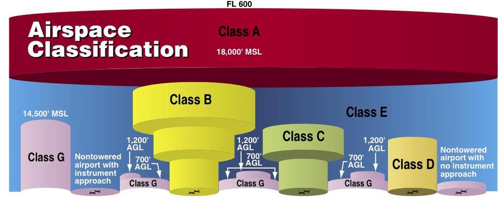
2 Controlled Airspace Controlled Airspace has defined dimensions within which Air Traffic Control (ATC) services are provided. The level of control varies with different classes of airspace.
3 Controlled Airspace
4 Controlled Airspace Controlled Airspace is under the control of an Air Traffic Control (ATC) center. Class B Class C Class D Class E A licensed remote pilot must obtain ATC permission to operate in Class B, C and D and lateral E airspace.
5 Class A Airspace Not an issue for drone pilots info only From 18,000 feet (MSL) to 60,00 feet (MSL) Instrument Flight Rules (IFR) only Altitudes are in Flight Levels not Altitude Flight Level 200 = 20,000 feet Flight Level 500 = 50,000 feet MSL = above Mean Sea Level AGL = Above Ground Level
6 Class B Airspace Busiest Airports and Airspace Surface to 10,000 feet (MGL) There are 37 Class B airports in the USA. The nearest Class B airports are: ORD Chicago O Hare MSP Minneapolis St. Paul STL Lambert St. Louis MCI Kansas City
 radius, an outer circle with a ten NM radius that extends from 1,200 feet to")
7 Class C Airspace Operational control tower Radar approach control Minimum number of instrument flight rules (IFR) operations or passengers. Airspace usually consists of a surface area with a five nautical mile (NM) radius, an outer circle with a ten NM radius that extends from 1,200 feet to 4,000 feet (AGL)
 radius that extends to 2,500 feet")
8 Class D Airspace Operational control tower Instrument Flight Rules (IFR) operations Radar is optional May not have 24/7 operation Airspace usually consists of a surface area with a five nautical mile (NM) radius that extends to 2,500 feet (AGL)
9 Class E Airspace Class E Airspace is the most common Controlled Airspace and the most confusing! IFR aircraft must have ATC clearance to fly in Class E Airspace. VFR aircraft have a minimum required clearance with clouds. If an IFR aircraft comes out of the clouds, both aircraft have enough time to see and avoid the other aircraft.
10 Class G Airspace Uncontrolled Airspace No ATC From the ground to the bottom of the overlying Class E airspace Typically 700 feet to 1200 feet AGL (maximum of 14,500 feet MSL)
11 Waterloo Airport (ALO) Waterloo Airport is FAA Class D airspace. Class D airspace is typically around an airport with a functioning control tower, but without significant IFR approaches (usually because there is no scheduled commercial passenger service). Class D airspace is generally cylindrical in form and normally extends from the surface to 2,500 feet AGL (above ground level). On the chart, ALO is 3,400 feet above MSL (mean sea level) or 2527 AGL.
12 Waterloo Airport (ALO) Class E airspace is all the rest of the controlled airspace not already described. Most of this airspace is not near the surface, but aloft, where aircraft flying under IFR are in an en-route segment of flight. Over most of the country, the base of Class E airspace is at either 700 or 1,200 feet above the ground, so this isn t an issue for a small UAS operating at 400 feet and below. ALO has Class E airspace extending from the runways beyond the normal 4 NM (4.6 miles) radius down to ground level
13 Waterloo Airport (ALO)

14 Waterloo Regional Airport
15 RUNWAY NUMBERS Runway numbers are determined by rounding the magnetic compass bearing of the runway end to the nearest 10 degrees and truncating the last digit, meaning runways are numbered from 1 to So if you're on runway 9, you're heading east (90 on a compass). The opposite end of runway 9 is numbered 27 (or 270 on a compass). If an airport has parallel runways, these would then be marked Left, Center and Right, e.g. 9L/9C/9R
16 Waterloo Regional Airport Runways 12/30 18/36 6/24

17 Waterloo Airport (ALO)
18 Aircraft Altitude (AGL) on Approach to Runway
19 Air Traffic Control (ATC) It is important to understand that an air traffic controller s primary responsibility is to separate traffic on the runway. Aircraft in the air must not rely on controllers for separation. Pilots are always responsible to see-and-avoid other aircraft. The smaller the aircraft is, the harder it is to see. Drones, because of their extremely small size are nearly impossible for pilots in the air to see-andavoid.
20 Aeronautical Chart Types Sectional Chart covers several states and provides information for VFR (Visual Flight Rules) Part 107 Drone Pilot Test covers Sectional Chart information. Terminal Area Chart covers Class B airspace En-Route Chart provides navigation information for IFR (Instrument Flight Rules)
21 Standard Airport Traffic Pattern for uncontrolled airports There are five different legs of the traffic pattern: Upwind, Crosswind, Downwind, Base and Final.
22 Special Use Airspace (SUAS) Prohibited Area charted as a P followed by a number (e.g., P-49). Examples of include Camp David and the National Mall in Washington, D.C. Restricted charted with an R followed by a number (e.g., R-4401). If hot, an ATC clearance is required. If cold, no clearance is required. Warning Area designated with a W followed by a number (e.g., W-237) is only found offshore. Military Operation Area (MOA) depicted on sectional, VFR terminal area charts with a name (e.g., Camden Ridge MOA ).
23 Special Use Airspace (SUAS) Alert depicted on aeronautical charts with an A followed by a number (e.g., A-211). May contain pilot training or an unusual type of aerial activity. Pilots should exercise caution in alert areas. Controlled firing areas (CFAs) CFA activities are suspended when a spotter aircraft, radar or ground lookout position indicates an aircraft is approaching the area. There is no need to chart CFAs since they do not cause a nonparticipating aircraft to change its flightpath. VFR sectional charts depict MOA, restricted area, warning area and alert area information.
24 Special Area Of Operation (SAO) Military Training Route (MTR) routes used by military aircraft to maintain proficiency in tactical flying. Routes are identified as IFR (IR), and VFR (VR), followed by a number. MTRs with no segment above 1,500 feet AGL are identified by four number characters (e.g., IR1206, VR1207). MTRs that include one or more segments above 1,500 feet AGL are identified by three number characters (e.g., IR206, VR207. VFR sectional charts depict IR and VR areas.
25 Special Area Of Operation (SAO) Temporary Flight Restriction (TFR) A Notice to Airmen (NOTAM) is issued to designate a TFR. Parachute Jump Aircraft Operations Sites are frequently depicted on sectional charts. Published VFR routes for transitioning around, under, or through some complex airspace. These routes are generally found on VFR terminal area planning charts. Terminal Radar Service Areas (TRSAs) areas with additional radar services. The purpose is to provide separation between IFR operations and VFR aircraft.
26 Special Area Of Operation (SAO) National Security Areas (NSAs) established airspace where there is a need for increased security and safety of ground facilities. Pilots are requested to voluntarily avoid flying through these areas. Local Airport Advisory (LAA) automated weather reporting with voice broadcasting and a continuous ASOS/AWOS data display


27 Low Altitude Authorization and Notification Capability (LAANC) LAANC (pronounced LANCE ) enables drone pilots access to controlled airspace near airports through near real-time processing of airspace authorizations below approved altitudes in controlled airspace. Drone pilots can use applications developed by approved UAS Service Suppliers to access the LAANC capability.
28 Waterloo Airspace

29 Waterloo LAANC Area

30 Waterloo LAANC Grid
31 Current LAANC Service Providers Aeronyde Airbus AirMap AiRXOS Altitude Angel Converge DJI Harris Corporation Kittyhawk Project Wing Skyward Thales Group UASidekick Unifly
32 GEOFENCING Geofencing the use of GPS technology to create a virtual geographic boundary, enabling software to trigger a response when a mobile device enters or leaves a particular area. In January 2015, a DJI Phantom drone went astray and landed in a tree on the wrong side of the White House fence, leading to much alarm. DJI announced they would issue a mandatory firmware update for its products that would contain built-in geofencing limits within which their updated GPS-enabled drones simply would not fly.
33 Geofence Zones Restricted Zones. In these Zones, which appear red on the map, users will be prompted with a warning and flight is prevented. Example Restricted Zone: Black Hawk County Jail Authorization Zones. In these Zones, which appear yellow on the map, users will be prompted with a warning and flight is limited by default. Authorization Zones may be unlocked by authorized users using a verified account. Example Authorization Zone: Model aircraft flying club near an airport.
34 Geofence Zones Enhanced Warning Zones. In these Zones which appear green on the map, you will be prompted by at the time of flight to unlock the zone using the same steps as in an Authorization Zone, but you do not require a verified account or an internet connection at the time of your flight. Example Enhanced Warning Zone: A farm which is 3 miles away from an airport. Warning Zones. In these Zones, which may not necessarily appear on the map, users will be prompted with a warning message. Example Warning Zone: A national park or monument.

35 Geofence Zones

36 Geofence Zones

37 Geofence Zones
Airspace. Chapter 14. Gold Seal Online Ground School. Introduction
 Gold Seal Online Ground School www.onlinegroundschool.com Chapter 14 Airspace Introduction The two categories of airspace are: regulatory and nonregulatory. Within these two categories there are four types:
APPENDIX F AIRSPACE INFORMATION
 APPENDIX F AIRSPACE INFORMATION Airspace Use DEFINITION OF AIRSPACE Airspace, or that space which lies above a nation and comes under its jurisdiction, is generally viewed as being unlimited. However,
Appendix K: MSP Class B Airspace
 Appendix K: MSP Class B Airspace K All of the open sky covering the United States, from less than an inch off the ground all the way to outer space, is part of America s airspace. This airspace resource
Class Alpha. In addition, if you fly above FL240 your aircraft must have DME or a suitable RNAV system.
 Go For It Class Alpha Class A airspace is from 18,000 feet MSL to Flight Level 600 (60,000 feet pressure altitude). Its lateral extent includes the contiguous U.S. and Alaska, and extends 12 nm from the
Class B Airspace. Description
 Class B Airspace Ref. AIM 3-2-3 and FAR 91.131 Surrounds certain large airports Within each Class B airspace area, there are multiple segments with different ceiling/floor altitudes. Example: 70/30 = ceiling
FLASHCARDS AIRSPACE. Courtesy of the Air Safety Institute, a Division of the AOPA Foundation, and made possible by AOPA Holdings Company.
 AIRSPACE FLASHCARDS Courtesy of the Air Safety Institute, a Division of the AOPA Foundation, and made possible by AOPA Holdings Company. The Air Safety Institute is dedicated to making flying easier and
NAVIGATION: CHARTS, PUBLICATIONS, FLIGHT COMPUTERS (chapters 7 & 8)
") NAVIGATION: CHARTS, PUBLICATIONS, FLIGHT COMPUTERS (chapters 7 & 8) LONGITUDE AND LATITUDE 1. The location of an airport can be determined by the intersection of lines of latitude and longitude. a. Lines
NAVIGATION: CHARTS, PUBLICATIONS, FLIGHT COMPUTERS (chapters 7 & 8) LONGITUDE AND LATITUDE 1. The location of an airport can be determined by the intersection of lines of latitude and longitude. a. Lines
What you might learn depending on your level of drowsiness! Brief summary of US airspace history US airspace structure & regulatory requirements Speci
 Northern California Soaring Association 2010 Safety Seminar Airspace by Mike Voie, CFIG What you might learn depending on your level of drowsiness! Brief summary of US airspace history US airspace structure
a. Aeronautical charts DID THIS IN LESSON 2
 AIRMAN CERTIFICATION STANDARDS: REMOTE PILOT SMALL: You will know and be able to explain in writing or oral form the below tasks regarding AIRPORT OPERATIONS Task References Objective Task B. Airport Operations
Civil/Military Coordination Workshop Havana, Cuba April 2015
 Civil/Military Coordination Workshop Havana, Cuba 13-17 April 2015 Civil/Military Coordination in the United States based on Appendix A of ICAO Circular 330 Dave Edwards, U.S. Coast Guard Chairman, ICAO/International
Teaching the National Airspace System. Soaring Safety Foundation FIRC Presentation
 Teaching the National Airspace System Soaring Safety Foundation FIRC Presentation US Airspace Training Aids http://www.airnav.com Details of any airport http://www.skyvector.com On-line copies of sectional
Airspace Establishment Project Frequently Asked Questions Permanent SUA and Environmental Assessment March 2019
 OVERVIEW OF PERMANENT SPECIAL USE AIRSPACE ESTABLISHMENT AND MODIFICATIONS AT MARINE AIR GROUND TASK FORCE TRAINING COMMAND, TWENTYNINE PALMS, CA 1. What is Special Use Airspace (SUA)? Special Use Airspace
CE 563 Airport Design
 CE 563 Airport Design Prevent aircraft collisions Prevent aircraft collisions with obstructions Expedite and maintain an orderly flow of air traffic Air traffic control system command center Herndon, VA
FLIGHT ADVISORY WASHINGTON D.C. SPECIAL FLIGHT RULES AREA LEESBURG MANUVERING AREA
 FLIGHT ADVISORY WASHINGTON D.C. SPECIAL FLIGHT RULES AREA LEESBURG MANUVERING AREA EFFECTIVE October 11, 201609 0400 This Notice does not supersede restrictions pertaining to the use of airspace contained
FAA FORM UAS COA Attachment FAA
 Page 1 of 6 DEPARTMENT OF TRANSPORTATION FEDERAL AVIATION ADMINISTRATION CERTIFICATE OF WAIVER OR AUTHORIZATION ISSUED TO Xcam Aerials, Inc. 10197 SE 144th Place Summerfield, FL 34491 This certificate
DO NOT BEGIN THIS WORK UNTIL YOU HAVE COMPLETED ALL REQUIRED ASSIGNED READING AND EXERCISES.
 DO NOT BEGIN THIS WORK UNTIL YOU HAVE COMPLETED ALL REQUIRED ASSIGNED READING AND EXERCISES. Gardner Textbook Review Questions to prepare for Class #12 Answer these on notebook paper (or a text file) then
Jeppesen Mobile FliteDeck VFR
 Airport Information CLEARWATER INTL (PIE) 10 Rwy9730 118.30 CTAF Location Name Fuel and Services Available Identifier Length of longest runway Frequency (public airports only) Airport Elevation 118.60
NOTAM. Aircraft Owners and Pilots Association (AOPA) Fly-In Colorado Springs Airport (COS) Colorado Springs, CO SPECIAL FLIGHT PROCEDURES
 Fly-In Colorado Springs Airport (COS) Colorado Springs, CO SPECIAL FLIGHT PROCEDURES") NOTAM Aircraft Owners and Pilots Association (AOPA) Fly-In Colorado Springs Airport (COS) Colorado Springs, CO SPECIAL FLIGHT PROCEDURES EFFECTIVE 12:00 Noon Local Friday, September 25, 2015 Until 6:00
NOTAM Aircraft Owners and Pilots Association (AOPA) Fly-In Colorado Springs Airport (COS) Colorado Springs, CO SPECIAL FLIGHT PROCEDURES EFFECTIVE 12:00 Noon Local Friday, September 25, 2015 Until 6:00
Chapter 9 - Airspace: The Wild Blue, Green & Red Yonder
 I5 Class G Airspace 38. [I4/3/3] What minimum visibility and clearance from clouds are required for VFR operations in Class G airspace at 700 feet AGL or lower during daylight hours? A. mile visibility
Airspace. Uncontrolled Airspace
 S A F E T Y A D V I S O R Regulations No. 1 Airspace F o r E v e r y o n e In this Safety Advisor, we will examine the airspace structure and how pilots are expected (and required by the Federal Aviation
ELEMENTS OF THE NATIONAL AIRSPACE SYSTEM
 ELEMENTS OF THE NATIONAL The National Airspace System is an interconnected system of airports, air traffic facilities and equipment, navigational aids, and airways. These elements of the NAS are operated
Pope Field, NC MID-AIR COLLISION AVOIDANCE
 Pope Field, NC MID-AIR COLLISION AVOIDANCE 2017 43 rd Air Mobility Operations Group Flight Safety, Pope Field, NC Tel: (910)394-8383/ 8389 Fax: (910)394-8098 E-mail:43AMOGW.SE1@US.AF.MIL The potential
AOPA FLY-IN NOTAM MAY BEAUFORT, NC SPECIAL FLIGHT PROCEDURES EFFECTIVE
 AOPA FLY-IN NOTAM MAY 20-21 BEAUFORT, NC SPECIAL FLIGHT PROCEDURES EFFECTIVE 12:00 Noon EDT Until 8:00PM EDT Friday, May 20, 2016 and 6:00AM EDT Until 8:00PM EDT Saturday, May 21, 2016 VFR ARRIVALS OVERVIEW
What Is The 29Palms Training Land Acquisition and Airspace Establishment Project Frequently Asked Questions Airspace Related July 2015
 MARINE CORPS / DEPARTMENT OF THE NAVY SUBMIT SPECIAL USE AIRSPACE PROPOSALS TO THE FEDERAL AVIATION ADMINISTRATION TO MEET MARINE EXPEDITIONARY BRIGADE TRAINING REQUIREMENTS 1. Why has the Marine Corps
JACK EDWARDS NATIONAL AIRPORT (JKA) GULF SHORES, AL
 GULF SHORES, AL") OCTOBER 26-27, 2018 JACK EDWARDS NATIONAL AIRPORT (JKA) GULF SHORES, AL SPECIAL FLIGHT PROCEDURES EFFECTIVE: Thursday Oct 25, 2018 12:00 NOON CDT until 6:00 PM CDT Friday Oct 26, 2018 7:00 AM CDT until
OCTOBER 26-27, 2018 JACK EDWARDS NATIONAL AIRPORT (JKA) GULF SHORES, AL SPECIAL FLIGHT PROCEDURES EFFECTIVE: Thursday Oct 25, 2018 12:00 NOON CDT until 6:00 PM CDT Friday Oct 26, 2018 7:00 AM CDT until
Fresno Area Mid-Air Collision Avoidance Program (MACA) California Air National Guard 144 th Fighter Wing, Fresno, CA
 California Air National Guard 144 th Fighter Wing, Fresno, CA") Fresno Area Mid-Air Collision Avoidance Program (MACA) California Air National Guard 144 th Fighter Wing, Fresno, CA As of March 2013 Mid-Air Collision Avoidance This briefing contains material that can
Fresno Area Mid-Air Collision Avoidance Program (MACA) California Air National Guard 144 th Fighter Wing, Fresno, CA As of March 2013 Mid-Air Collision Avoidance This briefing contains material that can
What Is The Proposed 29Palms Training Land Acquisition and Airspace Establishment Project? Frequently Asked Questions Airspace Related June 2014
 MARINE CORPS / DEPARTMENT OF THE NAVY SUBMIT SPECIAL USE AIRSPACE PROPOSALS TO THE FEDERAL AVIATION ADMINISTRATION TO MEET MARINE EXPEDITIONARY BRIGADE TRAINING REQUIREMENTS 1. Why has the Marine Corps
Commit to Safety: Professional Pilots Always Use a Checklist INITIAL EQUIPMENT SETUP
 Commit to Safety: Professional Pilots Always Use a Checklist INITIAL EQUIPMENT SETUP READ THE MANUAL Familiarize yourself with all aspects of your suas before you even consider going out for your first
H O M E C O M I N G. NOTAM Aircraft Owners and Pilots Association (AOPA) Fly-In Frederick Municipal Airport (FDK) Frederick, MD
 Fly-In Frederick Municipal Airport (FDK) Frederick, MD") F L Y - I N AOPA H O M E C O M I N G FREDERICK, MD NOTAM Aircraft Owners and Pilots Association (AOPA) Fly-In Frederick Municipal Airport (FDK) Frederick, MD SPECIAL FLIGHT PROCEDURES EFFECTIVE 1200 NOON
F L Y - I N AOPA H O M E C O M I N G FREDERICK, MD NOTAM Aircraft Owners and Pilots Association (AOPA) Fly-In Frederick Municipal Airport (FDK) Frederick, MD SPECIAL FLIGHT PROCEDURES EFFECTIVE 1200 NOON
AIRPORTS There are two types of airport environments: controlled and uncontrolled. A controlled airport has an operating control tower, staffed by
 AIRPORTS There are two types of airport environments: controlled and uncontrolled. A controlled airport has an operating control tower, staffed by either Federal or privately-contracted air traffic controllers.
FLIGHT ADVISORY NATIONAL SPECIAL SECURITY EVENT UNITED NATIONS GENERAL ASSEMBLY UNGA-67 SEPTEMBER 18, 2012 September 28, 2012
 FEDERAL AVIATION ADMINISTRATION FLIGHT ADVISORY NATIONAL SPECIAL SECURITY EVENT UNITED NATIONS GENERAL ASSEMBLY UNGA-67 SEPTEMBER 18, 2012 September 28, 2012 This advisory will serve as notice of flight
Municipal Drone Operations Ben Roper City of College Station
 Municipal Drone Operations Ben Roper City of College Station Unmanned Aerial System (UAS) aka Drone You are establishing an aviation unit for your entity What could possible go wrong? What is Needed Register
Chapter 9 Enroute Flight
 Page 1 of 19 Chapter 9 Enroute Flight Table of Contents Pilotage Time Topography Dead Reckoning Plotting Courses Magnetic Variation Magnetic Deviation Wind and Its Effects The Flight Computer (E6-B) Finding
Municipal Drone Operations Ben Roper City of College Station
 Municipal Drone Operations Ben Roper City of College Station Unmanned Aerial System (UAS) aka Drone You are establishing an aviation unit for your entity What could possible go wrong? https://youtu.be/aolm1aqkews
EFFECTIVE NOTAM KOUN SPECIAL FLIGHT PROCEDURES 09/08 NORMAN, OK
 KOUN WESTHEIMER AIRPORT NORMAN, OK 17 09/08 09/09 NOTAM SPECIAL FLIGHT PROCEDURES EFFECTIVE 12:00 Noon CDT until 7:30 PM CDT Thursday, September 7, 2017 7:00 AM CDT until 7:30 PM CDT Friday, September
Chapter 6. Nonradar. Section 1. General DISTANCE
 12/10/15 JO 7110.65W Chapter 6. Nonradar Section 1. General 6 1 1. DISTANCE Use mileage based (DME and/or ATD) procedures and minima only when direct pilot/controller communications are maintained. FIG
ex) & Comple nce Avoidan 1 August 2010
 & Comple nce Avoidan 1 August 2010") 23 rd Wing, Detachment 1 MacDilll Air Force Base (Deployed Fighter Unit Comple ex) & Avon Park Air Force Range (Restricted Area R-2901) Mid-Air Collision Avoidan nce ( M.A.C. A.) 1 August 2010 Purpose
23 rd Wing, Detachment 1 MacDilll Air Force Base (Deployed Fighter Unit Comple ex) & Avon Park Air Force Range (Restricted Area R-2901) Mid-Air Collision Avoidan nce ( M.A.C. A.) 1 August 2010 Purpose
KTPF PETER O. KNIGHT AIRPORT TAMPA, FL 10/27 NOTAM SPECIAL FLIGHT PROCEDURES EFFECTIVE
 KTPF PETER O. KNIGHT AIRPORT TAMPA, FL 10/27 17 10/28 NOTAM SPECIAL FLIGHT PROCEDURES EFFECTIVE 12:00 Noon EDT until 7:00 PM EDT Thursday, October 26, 2017 7:00 AM EDT until 7:00 PM EDT Friday, October
Report from the Los Angeles Terminal Area Chart Subcommittee. October 2014
 Report from the Los Angeles Terminal Area Chart Subcommittee October 2014 ******* JOHN WAYNE RUNWAYS GET RENAMED ******** 1. Change LA TAC and Sectional Charts 20R Continued... CHART BULLETINS: CHANGES
CHAPTER 7. AIRSPACE 7.1 AFFECTED ENVIRONMENT
 CHAPTER 7. AIRSPACE 7.1 AFFECTED ENVIRONMENT 7.1.1 Definition of Resource 7.1.1.1 Airspace Management Airspace management is defined as directing, controlling, and handling flight operations in the volume
Advanced Rating Study Guide
 Advanced Rating Study Guide FAR Part 103--Ultralight Vehicles FAR Part 91 VFR/IFR Cruise Altitude Windsports Soaring Center 12623 Gridley Street Sylmar, CA 91342-3334 Tel: (818) 367-2430 Fax: (818) 367-5363
NOTAM AIRCRAFT OWNERS AND PILOTS ASSOCIATION (AOPA) FLY-IN CHINO AIRPORT (CNO) CHINO, CALIFORNIA
 FLY-IN CHINO AIRPORT (CNO) CHINO, CALIFORNIA") NOTAM AIRCRAFT OWNERS AND PILOTS ASSOCIATION (AOPA) FLY-IN CHINO AIRPORT (CNO) CHINO, CALIFORNIA EFFECTIVE 12:00 NOON LOCAL FRIDAY, SEPTEMBER 19, 2014 UNTIL 6:00 PM LOCAL SATURDAY, SEPTEMBER 20, 2014 TEMPORARY
NOTAM AIRCRAFT OWNERS AND PILOTS ASSOCIATION (AOPA) FLY-IN CHINO AIRPORT (CNO) CHINO, CALIFORNIA EFFECTIVE 12:00 NOON LOCAL FRIDAY, SEPTEMBER 19, 2014 UNTIL 6:00 PM LOCAL SATURDAY, SEPTEMBER 20, 2014 TEMPORARY
Letter of Agreement. Between Jacksonville ARTCC and Virtual United States Navy Effective Date: Sept 1, 2008
 Letter of Agreement Between Jacksonville ARTCC and Virtual United States Navy Effective Date: Sept 1, 2008 Purpose: This Letter of Agreement (LOA) outlines standard operating policies and procedures to
US Airspace A History
 US Airspace A History The Federal airway system began in 1927, when the Department of Commerce acquired the transcontinental airway from the U.S. Postal Service. All airspace was uncontrolled, there were
F L Y - I N AOPA NOTAM. Aircraft Owners and Pilots Association (AOPA) Fly-In Salinas Municipal Airport (SNS) Salinas, CA SPECIAL FLIGHT PROCEDURES
 Fly-In Salinas Municipal Airport (SNS) Salinas, CA SPECIAL FLIGHT PROCEDURES") F L Y - I N AOPA SALINAS, CA NOTAM Aircraft Owners and Pilots Association (AOPA) Fly-In Salinas Municipal Airport (SNS) Salinas, CA SPECIAL FLIGHT PROCEDURES EFFECTIVE 1200 NOON local Friday, May 15, 2015
F L Y - I N AOPA SALINAS, CA NOTAM Aircraft Owners and Pilots Association (AOPA) Fly-In Salinas Municipal Airport (SNS) Salinas, CA SPECIAL FLIGHT PROCEDURES EFFECTIVE 1200 NOON local Friday, May 15, 2015
AOPA FLY-IN PACKET EFFECTIVE SPECIAL FLIGHT PROCEDURES SEPT BATTLE CREEK, MI W K KELLOGG AIRPORT (KBTL) PILOT INFORMATION
 PILOT INFORMATION") AOPA FLY-IN W K KELLOGG AIRPORT (KBTL) PILOT INFORMATION PACKET SEPT 16-17 BATTLE CREEK, MI SPECIAL FLIGHT PROCEDURES EFFECTIVE 12:00 Noon EDT until 6:00PM EDT Friday, September 16 and 7:00AM EDT until
AOPA FLY-IN W K KELLOGG AIRPORT (KBTL) PILOT INFORMATION PACKET SEPT 16-17 BATTLE CREEK, MI SPECIAL FLIGHT PROCEDURES EFFECTIVE 12:00 Noon EDT until 6:00PM EDT Friday, September 16 and 7:00AM EDT until
NextGen Priorities: Multiple Runway Operations & RECAT
 NextGen Priorities: Multiple Runway Operations & RECAT May 2018 Presented by Paul Strande & Jeffrey Tittsworth Federal Aviation Administration National Airspace System Today Air traffic services for the
4.2 AIRSPACE. 4.2 Airspace. Supplemental Draft Environmental Impact Statement August 2008 Military Training Activities at Mākua Military Reservation
 4.2 AIRSPACE 4.2.1 Impact Methodology Impacts on airspace use were assessed by evaluating the potential effects of the proposed training activities on the principal attributes of airspace use, as described
SANTA FE MUNICIPAL AIRPORT (SAF) SANTA FE, NM
 SANTA FE, NM") SEPTEMBER 13-15, 2018 SANTA FE MUNICIPAL AIRPORT (SAF) SANTA FE, NM SPECIAL FLIGHT PROCEDURES EFFECTIVE: Thursday Sept 13, 2018 12:00 NOON MDT until 7:00 PM MDT Friday Sept 14, 2018 7:00 AM MDT until 7:00
SEPTEMBER 13-15, 2018 SANTA FE MUNICIPAL AIRPORT (SAF) SANTA FE, NM SPECIAL FLIGHT PROCEDURES EFFECTIVE: Thursday Sept 13, 2018 12:00 NOON MDT until 7:00 PM MDT Friday Sept 14, 2018 7:00 AM MDT until 7:00
DIRECCION DE PERSONAL AERONAUTICO DPTO. DE INSTRUCCION PREGUNTAS Y OPCIONES POR TEMA
 T E M : 0322 INSTRUTOR_DVNED_07_PROEDURES & IRPT OPS OD_PREG: P R E G U N T : RPT: 6436 n airport without a control tower lies within the controlled airspace of an airport with an operating tower. ccording
Gleim Private Pilot Syllabus Fifth Edition, 3rd Printing Updates March 2016
 Page of Gleim Private Pilot Syllabus Fifth Edition, rd Printing Updates March 0 NOTE: Text that should be deleted is displayed with a line through it. New text is shown with a blue background. If you see
Table 5-15 Special Use Airspace in the SBMR Airspace ROI
 5.4 AIRSPACE 5.4.1 Affected Environment The affected airspace environment is described below in terms of its principal attributes, namely controlled and uncontrolled airspace, special use airspace, military
EFFECTIVE NOTAM KGON 10/06 SPECIAL FLIGHT PROCEDURES GROTON, CT
 KGON GROTON-NEW LONDON AIRPORT GROTON, CT 17 10/06 10/07 NOTAM SPECIAL FLIGHT PROCEDURES EFFECTIVE 12:00 Noon EDT until 6:00 PM EDT Thursday, October 5, 2017 7:00 AM EDT until 6:00 PM EDT Friday, October
Buttonville Flying Club
 Buttonville Flying Club 2833 16th Ave. Markham, ON L3R 0P8 Date: February 6, 2019 Subject: Mandatory Frequency Area at TORONTO Buttonville Municipal Airport (CYKZ) Procedures Executive Summary FOR VFR
R-2508 COMPLEX R-2515 SFC TO UNLIMITED
 R-2508 COMPLEX R-2515 SFC TO UNLIMITED R-2515 Info available online @... http://www.edwards.af.mil/home/r-2515-airspace R-2515 Airspace Brief EAFBI 13-100 PPR Requests SPORT Pre-Brief Sheet EAFB Wx R-2508
MAP SYMBOLS APPENDIX F BASEMAP AIRPORT TIS AND TAS TRAFFIC NAVAIDS Rev. A Garmin G1000 Pilot s Guide for Cessna Nav III
 MAP SYMBOLS AIRPORT Unknown Airport Non-towered, Non-serviced Airport BASEMAP Interstate Highway State Highway Towered, Non-serviced Airport US Highway National Highway Non-towered, Serviced Airport Towered,
STUDENT PILOT PRE-CROSS-COUNTRY WRITTEN EXAM
 DO NOT WRITE ON THIS TEST FEB 2013 STUDENT PILOT PRE-CROSS-COUNTRY WRITTEN EXAM This test is required prior to solo cross-country per AFMAN This test is not required if the student has passed the FAA Knowledge
Contents. Subpart A General 91.1 Purpose... 7
 Contents Rule objective... 3 Extent of consultation... 3 Summary of comments... 4 Examination of comments... 6 Insertion of Amendments... 6 Effective date of rule... 6 Availability of rules... 6 Part 91
F L I G H T S A F E T Y F O U N D A T I O N. Vol. 48 No. 11 For Everyone Concerned with the Safety of Flight November 1991
 F L I G H T S A F E T Y F O U N D A T I O N Accident Prevention Vol. 48 No. 11 For Everyone Concerned with the Safety of Flight November 1991 Special Use Airspace and Military Training Routes Pilots must
FEDERAL AVIATION ADMINISTRATION CENTRAL EN ROUTE AND OCEANIC AREA OPERATIONS FORT WORTH ARTC CENTER, MAJORS ATCT, AND SKYDIVE TANDEM GREENVILLE, LLC
 FEDERAL AVIATION ADMINISTRATION CENTRAL EN ROUTE AND OCEANIC AREA OPERATIONS FORT WORTH ARTC CENTER, MAJORS ATCT, AND SKYDIVE TANDEM GREENVILLE, LLC LETTER OF AGREEMENT Effective: April 10,2012 SUBJECT:
PILOT INFORMATION PACKET
 PILOT INFORMATION PACKET Aircraft Owners and Pilots Association (AOPA) Fly-In Tullahoma Regional Airport (THA) Tullahoma, TN SPECIAL FLIGHT PROCEDURES EFFECTIVE 12:00 Noon CDT Until 6:00PM CDT Friday,
Pre-Solo Written Exam
 Pre-Solo Written Exam Introduction 14 CFR Part 61.87(b) requires student pilots to demonstrate aeronautical knowledge by completing a knowledge test prior to soloing an aircraft. The test must address
THE TOWER CONTROL POSITION (TWR)
") 1. Introduction THE TOWER CONTROL POSITION (TWR) The Aerodrome Local Control, or Tower (called TWR) controller has the responsibility of ensuring Air Traffic Control (ATC) Services within a restricted
1. Introduction THE TOWER CONTROL POSITION (TWR) The Aerodrome Local Control, or Tower (called TWR) controller has the responsibility of ensuring Air Traffic Control (ATC) Services within a restricted
leel NG CITY COUNCIL AGENDA REPORT Honorable Mayor and City Council Members
 oe", City of RE leel NG CITY COUNCIL AGENDA REPORT TO: Honorable Mayor and City Council Members FROM: Rick Moskwa Public Works Director Agenda Item No.: Meeting Date: 9- B January 23, 2017 ACTION REQUESTED:
MINIMUM FLIGHT ALTITUDES
 MINIMUM FLIGHT ALTITUDES 1. Introduction Minimum flight altitudes are created first to ensure safety, awareness and adequate radio navigation reception for aircraft flying at the same time in specific
USE OF RADAR IN THE APPROACH CONTROL SERVICE
 USE OF RADAR IN THE APPROACH CONTROL SERVICE 1. Introduction The indications presented on the ATS surveillance system named radar may be used to perform the aerodrome, approach and en-route control service:
60th Air Mobility Wing FAA Sacramento Flight Standards District Office
 MIDAIR COLLISION AVOIDANCE TRAVIS AFB CA March 2011 Contact Information 60th Air Mobility Wing Flight Safety Office (707) 424-1115 Fax (707) 424-1123 Airfield Management (707) 424-0028 Tower Chief (707)
INTRODUCTION. iii. National Aeronautical Charting Office, FAA AVN-510 SSMC4 Sta East-West Highway Silver Spring, MD
 INTRODUCTION iii This Chart User s Guide is intended to serve as a learning aid, reference document and an introduction to the wealth of information provided on aeronautical charts and publications of
1.1.3 Taxiways. Figure 1-15: Taxiway Data. DRAFT Inventory TYPICAL PAVEMENT CROSS-SECTION LIGHTING TYPE LENGTH (FEET) WIDTH (FEET) LIGHTING CONDITION
 WIDTH (FEET) LIGHTING CONDITION") 1.1.3 Taxiways EWN has an extensive network of taxiways and taxilanes connecting the terminal, air cargo, and general aviation areas with the runways as listed in Figure 1-15. A 50-foot wide parallel taxiway
1.1.3 Taxiways EWN has an extensive network of taxiways and taxilanes connecting the terminal, air cargo, and general aviation areas with the runways as listed in Figure 1-15. A 50-foot wide parallel taxiway
April 5, Dear Mr. Ready,
 50 F St. NW, Suite 750 Washington, D.C. 20001 T. 202-737-7950 F. 202-273-7951 www.aopa.org Mr. Kenneth Ready U.S. Department of Transportation Docket Operations 1200 New Jersey Avenue SE. West Building
AOPA FLY-IN PACKET EFFECTIVE PILOT INFORMATION SPECIAL FLIGHT PROCEDURES MAY BEAUFORT, NC
 AOPA FLY-IN PILOT INFORMATION PACKET MAY 20-21 BEAUFORT, NC SPECIAL FLIGHT PROCEDURES EFFECTIVE 12:00 Noon EDT Until 8:00PM EDT Friday, May 20, 2016 and 6:00AM EDT Until 8:00PM EDT Saturday, May 21, 2016
The NOTAM described will replace previously issued FDC NOTAMs 6/2550 and 7/7778 for the DC ADIZ/FRZ.
 This advisory covers published NOTAMs 7/0206 for the DC ADIZ, 7/0211 for the DC FRZ and FDC 7/0204 for the outer speed restriction. WARNING This document only contains an overview of the new rules for
EXPLANATION OF TPP TERMS AND SYMBOLS
 U.S. TERMINAL PROCEDURES PUBLICATION 52 EXPLANATION OF TPP TERMS AND SYMBOLS The discussions and examples in this section will be based primarily on the IFR (Instrument Flight Rule) Terminal Procedures
Proposed Establishment of and Modification to Restricted Areas; Fort Sill, OK
 This document is scheduled to be published in the Federal Register on 10/19/2015 and available online at http://federalregister.gov/a/2015-26499, and on FDsys.gov 4910-13 DEPARTMENT OF TRANSPORTATION Federal
R-2515 R-2508 COMPLEX
 R-2515 R-2508 COMPLEX Edwards AFB PPR Briefing Edwards AFB and Edwards Class D Surface Area lie within Restricted Area 2515: R-2515 and Edwards Class D Surface Area contain many flight hazards for aircrews
AVIATION INVESTIGATION REPORT A00Q0116 RISK OF COLLISION
 Transportation Safety Board of Canada Bureau de la sécurité des transports du Canada AVIATION INVESTIGATION REPORT A00Q0116 RISK OF COLLISION BETWEEN AIR CANADA AIRBUS INDUSTRIE A319-114 C-FYJB AND CESSNA
Fresno Area Mid-Air Collision Avoidance Program (MACA)
") Fresno Area Mid-Air Collision Avoidance Program (MACA) 144 th Fighter Wing California Air National Guard Fresno, CA 1 This pamphlet is courtesy of the 144 th Fighter Wing located at the California Air
Fresno Area Mid-Air Collision Avoidance Program (MACA) 144 th Fighter Wing California Air National Guard Fresno, CA 1 This pamphlet is courtesy of the 144 th Fighter Wing located at the California Air
[1] Gleim #: Source: AIM Para Learning Statement Code: PLT141
![[1] Gleim #: Source: AIM Para Learning Statement Code: PLT141](/thumbs/75/71500728.jpg "[1] Gleim #: Source: AIM Para Learning Statement Code: PLT141") Gleim FAA Test Prep: Private Pilot (15 questions) Unit 3a: Airports, Air Traffic Control, and Airspace Name: Date: Circle the correct answer on the question sheets and fill in the corresponding circle
Gleim FAA Test Prep: Private Pilot (15 questions) Unit 3a: Airports, Air Traffic Control, and Airspace Name: Date: Circle the correct answer on the question sheets and fill in the corresponding circle
ALTIMETER SETTING PROCEDURES
 AIP New Zealand ENR 1.7-1 ENR 1.7 ALTIMETER SETTING PROCEDURES 1 INTRODUCTION 1.1 General 1.1.1 The requirements for altimeter setting are detailed in CAR Part 91. The requirements are summarised in this
AIRSPACE STRUCTURE. In aeronautics, airspaces are the portion of the atmosphere controlled by a country above its territory.
 AIRSPACE STRUCTURE 1. Introduction In aeronautics, s are the portion of the atmosphere controlled by a country above its territory. There are two kinds of : Controlled is of defined dimensions within which
2014 NOTAM Special Flight Procedures. Plymouth, MA Effective 12:00 Noon (Local) July 11, 2014 Until 6:00PM (Local) July 12, 2014
 July 11, 2014 Until 6:00PM (Local) July 12, 2014") 2014 NOTAM Special Flight Procedures Plymouth, MA Effective 12:00 Noon (Local) July 11, 2014 Until 6:00PM (Local) July 12, 2014 AIRCRAFT OWNERS AND PILOTS ASSOCIATION (AOPA) FLY-IN PLYMOUTH, MASSACHUSETTS
2014 NOTAM Special Flight Procedures Plymouth, MA Effective 12:00 Noon (Local) July 11, 2014 Until 6:00PM (Local) July 12, 2014 AIRCRAFT OWNERS AND PILOTS ASSOCIATION (AOPA) FLY-IN PLYMOUTH, MASSACHUSETTS
APPENDIX I AIRSPACE TECHNICAL MEMO
 APPENDIX I AIRSPACE TECHNICAL MEMO Table of Contents 1.0 INTRODUCTION... 1 1.1 AIRSPACE REGULATORY FRAMEWORK... 7 1.2 RESOURCE DEFINITION... 7 1.3 DESCRIPTION OF PROPOSED SPECIAL USE AIRSPACE AND TRAINING
Introduction. Who are we & what do we do.
 Drones and the Law Introduction FAA s Regulations vs. Congress Legislation Recreational Use vs. Academic Use Private Property vs. Public Airspace Flying in Class B Airspace Working with MassPort Helpful
Stanfield VOR Procedures
 Stanfield VOR This PowerPoint is not intended as a directive. It is intended to serve as a tool to communicate the training community s best practices. Any questions or concerns to these procedures are
129 th RQW/SE P.O. Box 103, MS#1 Moffett Federal Airfield, CA
 MID-AIR COLLISION AVOIDANCE (MACA) HANDBOOK 129 th RQW/SE P.O. Box 103, MS#1 Moffett Federal Airfield, CA 94035-0103 129TH RESCUE WING MOFFETT FEDERAL AIRFIELD, CA 1 NOV 2013 TABLE OF CONTENTS FLYING SAFETY
OFWIM and DRONES How to stay out of trouble
 OFWIM and DRONES How to stay out of trouble AMA, FAA, and FARs FAA 2012 Reform and Modernization Act 2014 Interpretive Rule AMA 550 AMA 560 AC91-57 FAR 91.119 d1 NPRM Section 333 United States v. Causby328
Chapter 3. Airspace. Section 1. General
 12/10/15 Chapter 3. Airspace Section 1. General 3 1 1. General a. There are two categories of airspace or airspace areas: 1. Regulatory (Class A, B, C, D and E airspace areas, restricted and prohibited
EET-1250: FAA DRONE CERTIFICATION TEST PREPARATION
 EET-1250: FAA Drone Certification Test Preparation 1 EET-1250: FAA DRONE CERTIFICATION TEST PREPARATION Cuyahoga Community College Viewing:EET-1250 : FAA Drone Certification Test Preparation Board of Trustees:
4.6 AIRSPACE. Approach to Analysis
 4.6 AIRSPACE Section 4.6 describes the impacts that could potentially occur to the existing airspace environment from the proposed action. Potential impacts would stem from the establishment of new Special
The National Airspace System
 Chapter 8 The National Airspace System Introduction The National Airspace System (NAS) is the network of United States (U.S.) airspace: air navigation facilities, equipment, services, airports or landing
TRAVIS AIRSPACE. For more information visit the Travis AFB Midair Collision Avoidance (MACA) public website at:
 public website at:") MIDAIR COLLISION AVOIDANCE TRAVIS AFB CA January 2007 TRAVIS AIRSPACE The airspace serviced by Travis Approach Control is used by military aircraft operating in this area, along with IFR and numerous
MIDAIR COLLISION AVOIDANCE TRAVIS AFB CA January 2007 TRAVIS AIRSPACE The airspace serviced by Travis Approach Control is used by military aircraft operating in this area, along with IFR and numerous
Advisory Circular. General Safety Practices Model Aircraft and Unmanned Air Vehicle Systems
 Advisory Circular Subject: General Safety Practices Model Aircraft and Unmanned Air Vehicle Systems Issuing Office: Civil Aviation, Standards Document No.: AC 600-002 File Classification No.: Z 5000-34
[1] Gleim #: Source: PHAK Chap 15
![[1] Gleim #: Source: PHAK Chap 15](/thumbs/87/97364752.jpg "[1] Gleim #: Source: PHAK Chap 15") Gleim FAA Test Prep: Private Pilot (12 questions) Study Unit 9 [Navigation: Charts and Publications] Name: Date: [1] Gleim #: 9.1.2 -- Source: PHAK Chap 15 (Refer to Figure 21.) (Refer to area 3.) Determine
Gleim FAA Test Prep: Private Pilot (12 questions) Study Unit 9 [Navigation: Charts and Publications] Name: Date: [1] Gleim #: 9.1.2 -- Source: PHAK Chap 15 (Refer to Figure 21.) (Refer to area 3.) Determine
Navigation Enroute Flight
 Name: 1 (3067)- The width of a Federal Airway from either side of the centerline is A- 4 nautical miles. B- 6 nautical miles. C- 8 nautical miles. 2 (3068)- Unless otherwise specified, Federal Airways
CHICAGOLAND SPEEDWAY NASCAR RACES
 CHICAGOLAND SPEEDWAY NASCAR RACES JUNE 28 THROUGH JULY 2, 2018 In anticipation of a significant number of aircraft traveling to the Chicago, Illinois, area during the Chicagoland Speedway NASCAR races,
MAR-A-LAGO TFR PROCEDURES
 MAR-A-LAGO TFR PROCEDURES PBI PLAYBOOK Presented to: Pilots and Stakeholders By: USSS and FAA Date: PBI Departure PBI Arrival BCT CAYSL Arrival BCT Departure Traffic 12-26-2016 2 Table of Contents Chapter
** DETERMINATION OF NO HAZARD TO AIR NAVIGATION **
 Mail Processing Center Federal Aviation Administration Southwest Regional Office Obstruction Evaluation Group 2601 Meacham Boulevard Fort Worth, TX 76137 Issued Date: 05/16/2011 Aeronautical Study No.
ERIE ATCT STANDARD OPERATING PROCEDURES
 ORDER ERI ATCT 7110.10I ERIE ATCT STANDARD OPERATING PROCEDURES August 1, 2014 VATUSA CLEVELAND ARTCC VIRTUAL AIR TRAFFIC SIMULATION NETWORK VIRTUAL AIR TRAFFIC SIMULATE NETWORK UNITED STATES DIVISION
MISSOULA INTERNATIONAL AIRPORT (MSO) MISSOULA, MT
 MISSOULA, MT") JUNE 14-16, 2018 MISSOULA INTERNATIONAL AIRPORT (MSO) MISSOULA, MT SPECIAL FLIGHT PROCEDURES EFFECTIVE: Thursday June 14, 2018 12:00 NOON MDT until 7:30 PM MDT Friday June 15, 2018 6:00 AM MDT until 7:30
JUNE 14-16, 2018 MISSOULA INTERNATIONAL AIRPORT (MSO) MISSOULA, MT SPECIAL FLIGHT PROCEDURES EFFECTIVE: Thursday June 14, 2018 12:00 NOON MDT until 7:30 PM MDT Friday June 15, 2018 6:00 AM MDT until 7:30
Number April 2016
 Luxembourg Air Safety Bulletin Number 16-001 - April 2016 This Air Safety Bulletin examines a number of hazards related to flying in and out, and in the vicinity of, Luxembourg Airport. As the Direction