Airborne Remote Sensing Component of Marine Debris Monitoring
|
|
|
- Cora Annabelle Sanders
- 6 years ago
- Views:
Transcription
1 Airborne Remote Sensing Component of Marine Debris Monitoring Dr. Thomas H Mace Mace Geospatial, LLC Workshop on Mission Concepts for Marine Debris Sensing Honolulu, Hi, Jan 19 21, 2016
2 Multistage Remote Sensing Concept 1. Use model and satellite data to determine convergence zones and airborne flight target areas 2. Use Airborne Radar and air ship telemetry to define fine features of likely concentration of marine debris for ship search 3. Use ship and small UAS to spot and retrieve debris.

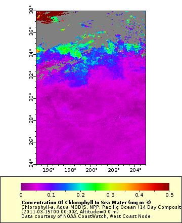
3 MODIS and SST Satellite Interpretatons
4 Envisat March 16 March 18 March 18 20:54:01 UTC Std 1 March 16 08:14:38 UTC Std 1 March 16 20:27:27 UTC Wide Swath Acquisition Box Std= standard beams, 100 km wide swath, 25 m resolution Wide Swath = 400 km wide swath, 150 m resolution Ben Holt JPL

5 Satellite SAR image showing eddy lines

6 UAVSAR polarimetric three color composite image of currents and eddies in the Santa Barbara Channel acquired on September 16, 2009, from the NASA G III aircraft overlain on Google Earth image (Image courtesy B Holt & Y Lou JPL).


 Designed for")
7 Gulfstream III UAV Synthetic Aperture Radar (UAVSAR) Capabilities Ceiling 45,000 ft. Duration 6 hours Range > 3,400 nautical miles Payload 2,610 lbs Mission Support Features Center-line pod/pylon supports UAVSAR instrument Precision flight path capability Shirtsleeve environment instrument support World-wide deployment capability UAVSAR Repeat-pass interferometry Ka-, P- and L-band capability (separate pods) Designed for UAV simulation Precision Flight Path Control 10 m
8 April, 2011 Mission/Feasibility Study Satellite Imagery for planning USCG C 130 for low altitude visual confirmation of debris G III interprets real time imagery onboard and sends coordinates to C 130 via base station and satphone Mission cancelled due to instrument failure We returned to Hawaii in May, but it was too late for environmental conditions


9 DC-8 Flying Laboratory Large Capacity, Long Range and Endurance Capabilities Ceiling 42,000 ft. Duration 12 hours Range > 5,400 nautical miles Payload 30,000 lbs Mission Support Features Shirtsleeve environment for up to 30 researchers Worldwide deployment experience Extensive modifications to support in-situ and remote sensing instruments zenith and nadir viewports wing pylons modified power systems 19 inch rack mounting AIRSAR Discontinued
 aircraft")
.")

10 NASA Global Hawks Two Advanced Concept Technology Demonstration (ACTD) aircraft transferred to NASA in September, 2007 (AV-1 and AV-6). AV 6 Aircraft are based at the Armstrong Flight Research Center on Edwards Air Force Base. Configuration and performance similar to standard Block 10. AV 1

11 NASA Global Hawk Summary and Capability NASA has been flying Global Hawk aircraft for airborne Earth science research since The autonomous aircraft are remotely operated from either NASA Armstrong Flight Research Center, NASA Wallops Flight Facility, or a portable Flight Control Station. A NASA/Northrop Grumman team is maintaining, modifying, and operating the 2 ACTD aircraft through a partnership that was established in 2008 and renewed in Currently only AV6 is flying, and a Block 10 aircraft is being made operational using avionics and interfaces from AV1 (early FY17) HS3 Profile ATTREX Profile 11 Typical Flight Profiles

")


12 NASA Global Hawk Asset Overview TN872 TN871 Global Hawk Operations Center East (WFF) Operational Aircraft Portable Ground Systems Global Hawk Operations Center (AFRC) Spares Aircraft 12
 Flight Operations Room (FOR) 14 Customer Workstations PDU Payload Operations Room")
13 Global Hawk Operations Center (GHOC) Room Layout at NASA AFRC Air Handler Equipment Racks GHOC Operator Mission Director Pilot Co-Pilot Range Safety Officer Facility Entrance Support Equipment Room (SER) Flight Operations Room (FOR) 14 Customer Workstations PDU Payload Operations Room (POR) 13

14 GHOC Fully Staffed During a Hurricane Overflight 14


15 Portable Ground Control Station Suite used for Deployed Operations Ku Satellite Ground Station Payload Mobile Operations Facility Global Hawk Mobile Operations Facility 15 15

16 Global Hawk time on station Based at EAFB
 17")
17 Global Hawk Science Flights (1 of 2) 17
 18")
18 Global Hawk Science Flights (2 of 2) 18

19 Airborne Tropical Tropopause Experiment Overview (October November 2011, February March 2013, January March 2014) 11 instruments were flown on the NASA Global Hawk aircraft in 2011 and 2013 and 12 instruments were flown in science missions, totaling 350 flight hours were flown during the 3 ATTREX campaigns. The flights in 2011 featured the first science demonstration in the tropics. The flights in 2014 featured the first OCONUS deployment for NASA Global Hawk. 19

20 ATTREX Flight Tracks 2013 Flights 2014 Flights EAFB Guam 20

21 IceHawk (December 2013) The UAV Synthetic Aperture Radar (UAVSAR) was integrated onto the aircraft. A single flight was conducted over the Pacific Ocean and Canada. This flight marked the first UAVSAR flight outside of the EAFB range and the first NASA Global Hawk flight over a foreign country. Coordination with the Canadian Government was straightforward. The IceHawk flight was funded by Northrop Grumman Co. as a platform capability demonstration-no instrument data were collected. 21
22 Options G III/UAVSAR is operational but limited flight time gives only a few passes over the target areas DC 8 has longer duration and ability to accommodate science team but UAVSAR has not been integrated Global Hawk has all the components necessary, but needs some component maturation as well as integration and testing of the fullup system All three platforms have satellite telemetry capability and telepresence, but large SAR files have not been demonstrated
23 Discussion
Operations of Suborbital Research Platforms to Obtain Remote Sensing Data
 National Aeronautics and Space Administration Operations of Suborbital Research Platforms to Obtain Remote Sensing Data Dennis Hines Director for Programs NASA Armstrong Flight Research Center November
NASA s Automatic Dependent Surveillance Broadcast: ADS-B Sense-and-Avoid System
 NASA s Automatic Dependent Surveillance Broadcast: ADS-B Sense-and-Avoid System October 30, 2014 Ricardo Arteaga NASA Armstrong Flight Research Center is a world class leader in cutting-edge Systems Engineer
Performance. Aircraft System
 German Aerospace Center Flight Operations Introduction DLR is Germany s aerospace research center and space agency with about 4700 employees in 31 research institutes distributed over 8 main research centers
AIRBORNE SCIENCE FLIGHT REQUEST National Aeronautics and Space Administration
 AIRBORNE SCIENCE FLIGHT REQUEST National Aeronautics and Space Administration LOG NUMBER Investigation Title: Rationale for use of NASA Facilities: NASA RTOP If checked, RTOP Number/Grant or Contract #
Space Based ADS-B. ICAO SAT meeting - June 2016 AIREON LLC PROPRIETARY INFORMATION
 Space Based ADS-B ICAO SAT meeting - June 2016 1 Options to Detect an Aircraft Position Position Accuracy / Update Interval Voice Position Reporting ADS-C Position Reporting Radar Surveillance / MLAT Space
Needs for UAS in Response
 UAS Potential Uses and Limitations October 21, 2015 Michele Jacobi Office Response and Restoration 10/27/2015 1 Needs for UAS in Response Limited access to areas of interest (distance, safety concerns,
Design, Development and Operation of UAVs for Remote Sensing. Mark Ewing, Director Flight Research Laboratory University of Kansas
 Design, Development and Operation of UAVs for Remote Sensing Mark Ewing, Director Flight Research Laboratory University of Kansas Why fly UAVs? Fly where human flight is too dangerous Fly at a reduced
PRO LINE FUSION INTEGRATED AVIONICS SYSTEM. Pro Line Fusion on Gulfstream G280: Your direct path to see and access more.
 Pro Line Fusion on Gulfstream G280: Your direct path to see and access more. Starting with its baseline features, the Pro Line Fusion avionics in your Gulfstream PlaneView280 flight deck offer capabilities
UNCLASSIFIED FY 2016 OCO. FY 2016 Base
 Exhibit P-40, Budget Line Item Justification: PB 2016 Air Force Date: February 2015 3010F: Aircraft Procurement, Air Force / BA 05: Modification of Inservice Aircraft / BSA 5: Other Aircraft ID Code (A=Service
Integrated Applications Programme (IAP) & Space for UAS UAS for Applications
 & Space for UAS UAS for Applications") ESA s Integrated Applications Programme (IAP) & Space for UAS UAS for Applications M. Vaissiere ESA Director of Telecommunications and Integrated Applications Programme European High Level UAS Conference
ESA s Integrated Applications Programme (IAP) & Space for UAS UAS for Applications M. Vaissiere ESA Director of Telecommunications and Integrated Applications Programme European High Level UAS Conference
Airworthiness considerations for UAVs
 A general overview about the approach to a UAV System under current regulations for operation, airspace and certification Presentation by : STN ATLAS ELEKTRONIK Klaus Wohlers, LMP Airborne Systems Type
Airline Dispatchers Federation UAS Operations Rose Mooney October 5, 2011
 Airline Dispatchers Federation UAS Operations Rose Mooney October 5, 2011 Unmanned Aircraft Systems UAS Unmanned Aircraft System UAS is an unmanned aircraft and its associated components and persons required
ESA-EDA: Paving the Way for New UAS Capabilities in Europe
 ESA-EDA: Paving the Way for New UAS Capabilities in Europe Dr. Stefan Gustafsson, ESA Jens Fehler, EDA Noordwijk, 11 th 12 th May 2010 Integrated Application Promotion Earth Observation Telecommunication
Aeros 40D Sky Dragon. TYPE CERTIFIED BY: United States Federal Aviation Administration Civil Aviation Authorities: Europe and Asia
 Aeros 40D Sky Dragon The Aeros 40D Sky Dragon Airship The United States Federal Aviation Administration (FAA) Type Certified Aeros 40D Sky Dragon is the most advanced non rigid airship, incorporating innovative
NOAA UAS Alaska/Arctic Flight Operations NOAA Office of Marine and Aviation Operations (OMAO) CAPT Philip Hall, OMAO
 CAPT Philip Hall, OMAO") NOAA UAS Alaska/Arctic Flight Operations NOAA Office of Marine and Aviation Operations (OMAO) CAPT Philip Hall, OMAO Overview NOAA s Ship and Aircraft Fleet UAS Operations Arctic Focus AeroVironment Puma
NOAA UAS Alaska/Arctic Flight Operations NOAA Office of Marine and Aviation Operations (OMAO) CAPT Philip Hall, OMAO Overview NOAA s Ship and Aircraft Fleet UAS Operations Arctic Focus AeroVironment Puma
IAC 2011 Cape Town, October th
 Cape Town, October 05 05 th Project Partners External Supporters and Sponsors The Problem The Solution Overview S 2 BAS Concept of Operations Architecture Possible Applications Stakeholders Flight Phases
UNCLASSIFIED. UNCLASSIFIED Air Force Page 1 of 17 P-1 Line #55
 Exhibit P-40, Budget Line Item Justification: PB 2017 Air Force Date: February 2016 3010F: Aircraft Procurement, Air Force / BA 05: Modification of Inservice Aircraft / BSA 5: Other Aircraft ID Code (A=Service
RPAS-ATM Integration Demonstration
 RPAS-ATM Integration Demonstration Final Workshop FLARE: an OPA for technology validation L. Vecchione, P. De Matteis, A. Rispoli Capua - June 21 th 2016 The OPA paradigm The FAA paradigm specifies that
THE GROUND CONTROL ROOM AS AN ENABLING TECHNOLOGY IN THE UNMANNED AERIAL SYSTEM
 THE GROUND CONTROL ROOM AS AN ENABLING TECHNOLOGY IN THE UNMANNED AERIAL SYSTEM Gary Gear, Professor of Engineering Embry Riddle Aeronautical University, Prescott, Az. 86301 ggear@erau.edu Thomas Mace,
Establishing a Risk-Based Separation Standard for Unmanned Aircraft Self Separation
 Establishing a Risk-Based Separation Standard for Unmanned Aircraft Self Separation Roland E. Weibel, Matthew W.M. Edwards, and Caroline S. Fernandes MIT Lincoln laboratory Surveillance Systems Group Ninth
UAS in European Civil Airspace: USICO and SINUE Results
 UAS in European Civil Airspace: USICO and SINUE Results Dirk-Roger Schmitt 1, Frank Morlang 1, Sven Kaltenhäuser 1, Henk Hesselink 2 1 German Aerospace Center (DLR) 2 AT-One EEIG UAS Integration in Civil
Research Challenges Associated with Unmanned Aircraft Systems Airspace Integration
 Research Challenges Associated with Unmanned Aircraft Systems Airspace Integration Andrew Lacher 21 February 2012 For National Academy of Sciences: Aeronautics Research and Technology Roundtable MITRE
The role of Unmanned Aircraft System (AUS) in search and rescue (SAR) operations
 in search and rescue (SAR) operations") The role of Unmanned Aircraft System (AUS) in search and rescue (SAR) operations Captain: Abdelkhalik Kamaleldin Soliman Selmy College of Maritime Transport & Technology Arab Academy for Science, Technology
The role of Unmanned Aircraft System (AUS) in search and rescue (SAR) operations Captain: Abdelkhalik Kamaleldin Soliman Selmy College of Maritime Transport & Technology Arab Academy for Science, Technology
NASA Low Boom Flight Demonstration (LBFD) Project Overview
 Project Overview") NASA Low Boom Flight Demonstration (LBFD) Project Overview Presented by Craig Nickol LBFD PM February 27, 2018 Aviation Noise & Emissions Symposium Long Beach, CA 1 Outline Why LBFD? Overview of NASA Role
NASA Low Boom Flight Demonstration (LBFD) Project Overview Presented by Craig Nickol LBFD PM February 27, 2018 Aviation Noise & Emissions Symposium Long Beach, CA 1 Outline Why LBFD? Overview of NASA Role
Operational Evaluation of a Flight-deck Software Application
 Operational Evaluation of a Flight-deck Software Application Sara R. Wilson National Aeronautics and Space Administration Langley Research Center DATAWorks March 21-22, 2018 Traffic Aware Strategic Aircrew
Updates to Procedures at St. John s International Airport
 October 10, 2017 Updates to Procedures at St. John s International Airport This document provides notice of upcoming changes to instrument procedures being implemented by NAV CANADA at the St. John s International
Performance Analysis of Space-Based ADS-B
 Performance Analysis of Space-Based ADS-B MIT Lincoln Labs ATC Workshop December 5 th, 2017 Dr. Michael Garcia and John Dolan 1 Agenda Aireon Overview On-Orbit Acceptance Test (OOAT) Performance Results
FAA NextGENProgram & NEAR Laboratory. Massood Towhidnejad, PhD Director of NEAR lab
 FAA NextGENProgram & NEAR Laboratory Massood Towhidnejad, PhD Director of NEAR lab www.near.aero towhid@erau.edu U.S. Air Traffic System World s Most Demanding 689M Passengers/Year 36B Pounds of Cargo/Year
MULTIDISCIPLINARYMEETING REGARDING GLOBAL TRACKING
 International Civil Aviation Organization Global Tracking 2014-WP/1 5/5/14 WORKING PAPER MULTIDISCIPLINARYMEETING REGARDING GLOBAL TRACKING Montréal, 12 May to 13 May 2014 Agenda item 1: Explore the need
LAUNCHING YOUR UNMANNED AIRCRAFT PROGRAM
 LAUNCHING YOUR UNMANNED AIRCRAFT PROGRAM THE DARTDRONES TEAM UNMANNED AIRCRAFT APPLICATIONS AERIAL INSPECTIONS AERIAL INSPECTIONS Safer and faster alternative to visual inspection by an individual Damage
Fly at the speed of ingenuity on your Learjet 85
 rockwell collins Pro Line Fusion Avionics Fly at the speed of ingenuity on your Learjet 85 Image courtesy of Bombardier. Experience the most advanced avionics system ever offered on a mid-size jet. Achieve
Glossary. Part I Acronyms/Data Terminology. AIFSS -- Automated International Flight Service Station.
 Glossary Part I Acronyms/Data Terminology AC -- Air Carrier. AFSS -- Automated Flight Service Station. AIFSS -- Automated International Flight Service Station. ARTCC -- Air Route Traffic Control Center.
Unmanned Aircraft Systems (UAS): A Paradigm Shift in Aviation
: A Paradigm Shift in Aviation") Unmanned Aircraft Systems (UAS): A Paradigm Shift in Aviation Tom Haritos, Ed.S. Department of Aeronautical Science Embry-Riddle Aeronautical University Florida Airports Council (FAC) 2015 1 The trouble
Unmanned Aircraft Systems (UAS): A Paradigm Shift in Aviation Tom Haritos, Ed.S. Department of Aeronautical Science Embry-Riddle Aeronautical University Florida Airports Council (FAC) 2015 1 The trouble
UAS Symposium Key Research Challenges and Opportunities
 UAS Symposium Key Research Challenges and Opportunities Sabrina Saunders-Hodge, UAS R&D Portfolio Manager, FAA/NextGen Federal Aviation Administration Date: April 20, 2016 UAS Symposium Research & Development
small Unmanned Aircraft Systems Arlington Police Department June 28, 2011
 suas small Unmanned Aircraft Systems Arlington Police Department June 28, 2011 1. Overview of APD suas program to date 2. Discuss the C.O.A. (FAA certificate of authorization to fly) and restrictions
FLIGHT OPERATIONS PANEL
 International Civil Aviation Organization FLTOPSP/WG/2-WP/11 24/04/2015 WORKING PAPER FLIGHT OPERATIONS PANEL WORKING GROUP SECOND MEETING (FLTOPSP/WG2) Rome, Italy 4 to 8 May 2015 Agenda Item 6: Any Other
IAI - MALAT. IAI Unclassified
 IAI - MALAT Comprehensive UAS Solutions IAI Unclassified 1 Overview Malat is A World Leader in UAS Solutions Founded in 1974 50 customers worldwide More than 1000 UAVs produced and delivered Over 1,000,000
Emerging Locator & Flight Data Technology
 Emerging Locator & Flight Data Technology Agenda Near term Flight Locator Solutions - ACARS AOC / ACMS - ACARS ADS-C - Inmarsat Aspire 200 - SkyConnect / Iridium Flight Data Solutions - Existing Systems
UAS Training Solutions
 UAS Training Solutions UAS Training Solutions Training and operational support for mission readiness The use of unmanned aerial systems (UAS) by defence and security forces globally has grown over the
Investigation on Development of Agricultural Monitoring System Using Satellite Data
 Investigation on Development of Agricultural Monitoring System Using Satellite Data Genya SAITO (1), Daisuke KUNII (1), Naoki ISHITSUKA (2) (1) Tohoku University, 1-1,Tsutsumidori Amamiya-machi Aoba-ku,
Aus-DIRCM Lear Jet Flight Demonstration
 Aus-DIRCM Lear Jet Flight Demonstration Lyell Wedd Airborne Self Protection SPO Defence Materiel Organisation Canberra, ACT John Cole Tenix Defence Pty. Ltd. Second Avenue, Technology Park, Mawson Lakes
Location: 2. It shows on at least two more places an example of the principle of dichotomy,
 Problem 1 - Requirements Discovery for a Mars formation flying mission (45 minutes, 24 points) Delft University of Technology Course: Systems Engineering & Technical Time: Management Techniques (AE3-S01)
Helicopter Vector IFR
 Helicopter Vector IFR Gerry Wiseman IFR Survey Manager Contents What is IFR? Land IFR Method Dynamic IFR Survey Helicopter IFR Survey Northern Alberta Project MWD Relies on the Earth s Magnetic Field MWD
Hazard Identification Questionnaire
 Hazard Identification Questionnaire OVERVIEW This questionnaire is designed to help identify potential risks and help identify areas of risk exposure. It is not an exhaustive list. This questionnaire is
Airspace Encounter Models for Conventional and Unconventional Aircraft
 Airspace Encounter Models for Conventional and Unconventional Aircraft Matthew W. Edwards, Mykel J. Kochenderfer, Leo P. Espindle, James K. Kuchar, and J. Daniel Griffith Eighth USA/Europe Air Traffic
RACOON PROJECT Daniele Teotino - ENAV. RACOON Project Manager Head of SESAR JU Activity Coordination
 RACOON PROJECT Daniele Teotino - ENAV RACOON Project Manager Head of SESAR JU Activity Coordination RACOON in a Nutshell SESAR JU Very Large Scale Demonstration First Italian initiative on Remote TWR solutions
Definitions. U-SAFE : UAS Secure Autonomous Flight Environment. UTM: UAS Traffic Management
 Definitions U-SAFE : UAS Secure Autonomous Flight Environment UTM: UAS Traffic Management NUSTAR: National UAS Standardized Test and Rating 2 U-SAFE Award Dec 11, 2015 Signature Initiative in Central New
Update on the Center for Interdisciplinary Remotely- Piloted Aircraft Studies (CIRPAS)
") Update on the Center for Interdisciplinary Remotely- Piloted Aircraft Studies (CIRPAS) Change in National Oceanographic Facility Designation Report to the UNOLS Council November 1 2018 Luc Lenain Scripps
Update on the Center for Interdisciplinary Remotely- Piloted Aircraft Studies (CIRPAS) Change in National Oceanographic Facility Designation Report to the UNOLS Council November 1 2018 Luc Lenain Scripps
MetroAir Virtual Airlines
 MetroAir Virtual Airlines NAVIGATION BASICS V 1.0 NOT FOR REAL WORLD AVIATION GETTING STARTED 2 P a g e Having a good understanding of navigation is critical when you fly online the VATSIM network. ATC
Development and Testing of an Unmanned Aircraft Safety Beacon for Aerial Application Safety
 Development and Testing of an Unmanned Aircraft Safety Beacon for Aerial Application Safety Wayne Woldt, Ph.D., P.E., and Jacob Smith Biological Systems Engineering and School of Natural Resources University
SYSTEM DEVELOPMENT AND FLIGHT TEST SOLUTIONS
 SYSTEM DEVELOPMENT AND FLIGHT TEST SOLUTIONS EASA Part 21 Subpart J DOA www.gvhaerospace.com EXTENSIVE FLIGHT TEST EXPERIENCE OVER 15 YEARS OF HISTORY IN SUPPORTING SYSTEM DEVELOPMENT AND CERTIFICATION
Light UAS for forestry applications an Operational experience
 Light UAS for forestry applications an Operational experience European High Level Unmanned Aircraft Systems (UAS) Conferencen Lars Björk Swedish Forest Agency 1 Swedish Forest Agency Swedish Forest Agency
Roadmapping Breakout Session Overview
 Roadmapping Breakout Session Overview Ken Goodrich October 22, 2015 Definition Roadmap: a specialized type of strategic plan that outlines activities an organization can undertake over specified time frames
A Pilot s perspective
 The Challenges of Modern Approaches, from NPA/PA to 2D/3D operations airborne perspective A Pilot s perspective Stefan Fiedler IFALPA, VC German Cockpit IFALPA Position on PBN (December 2014) IFALPA welcomes
Federal Aviation Administration Flight Plan Presented at the Canadian Aviation Safety Seminar April 20, 2004
 Federal Aviation Administration Flight Plan 2004-2008 Presented at the Canadian Aviation Safety Seminar April 20, 2004 Challenges Reducing an Already Low Commercial Accident Rate Building an Air Traffic
EXAMPLE FLIGHT PLAN. Project Information UBC PRODUCTIONS APEX^ZERO. Prepared for: Paul Hodges Vice President, SFG Productions
 UBC PRODUCTIONS APEX^ZERO FLIGHT PLAN EXAMPLE Project Information Prepared for: Paul Hodges Vice President, SFG Productions Prepared by: Roger Apolinar & Eric Carpenter Remote Pilots in Command, APEX^ZERO
MASER SOUNDING ROCKET MICROGRAVITY FLIGHTS
 MASER SOUNDING ROCKET MICROGRAVITY FLIGHTS ANNOUNCEMENT OF FLIGHT OPPORTUNITIES BOOK YOUR FLIGHT TICKET! LAUNCH OPPORTUNITIES ON MASER OPEN NOW! World class flight ticket concept for your space mission!
Planning for RPAS Operations
 Planning for RPAS Operations Tom Wade, Facility Manager, University of Edinburgh Image courtesy of Simon Gibson-Poole (UoE/SRUC) at Introduction Terminology Strengths and Limitations is this the tool for
Continuous Descent Arrivals (CDA) Workshop #2
 Workshop #2") Continuous Descent Arrivals (CDA) Workshop #2 FAA Operational Evolution Plan (OEP): Version 8 CDA Core & Ring elements Presented to: EIPT Ops Panel & guests By: Sandy Liu, FAA Office of Environment & Energy
Continuous Descent Arrivals (CDA) Workshop #2 FAA Operational Evolution Plan (OEP): Version 8 CDA Core & Ring elements Presented to: EIPT Ops Panel & guests By: Sandy Liu, FAA Office of Environment & Energy
Application for a Special Flight Operations Certificate
 Application for a Special Flight Operations Certificate for a Large Unmanned High Altitude Balloon by Shaftesbury High School Shaftesbury High Altitude Robotics Project SHARP Date: November 1, 2013 Prepared
Products, Practices and Future
 ANSP Guideline for RPAS Operations Doug Davis Northrop Grumman Director of Airworthiness Chair, UAS WorkGroup Products, Practices and Future Scope Introduction and Objectives Conducting Routine RPAS Ops:
UNMANNED AIRCRAFT SYSTEMS (UAS) IN UTILITIES
 IN UTILITIES") UNMANNED AIRCRAFT SYSTEMS (UAS) IN UTILITIES Presented by: Dan Carbone Avion Unmanned Why Drones? Why Drones? Cost Effective Entire cost of a UAS program can be recouped in first-year man-hour savings
UNMANNED AIRCRAFT SYSTEMS (UAS) IN UTILITIES Presented by: Dan Carbone Avion Unmanned Why Drones? Why Drones? Cost Effective Entire cost of a UAS program can be recouped in first-year man-hour savings
International Civil Aviation Organization. Satellite spectrum to support the safe operation of Unmanned Aircraft Systems
 International Civil Aviation Organization Satellite spectrum to support the safe operation of Unmanned Aircraft Systems Loftur Jónasson, Air Navigation Bureau, ICAO 23 May 2012 Convention on International
U.S. Forest Service Explores Use of UAS In Fire Management Jennifer Jones Public Affairs Specialist Washington Office, Fire and Aviation Management
 U.S. Forest Service Explores Use of UAS In Fire Management Jennifer Jones Public Affairs Specialist Washington Office, Fire and Aviation Management On August 27, 2013, an unusual resource order was placed
HEAD-UP DISPLAY (HUD), EQUIVALENT DISPLAYS AND VISION SYSTEMS
, EQUIVALENT DISPLAYS AND VISION SYSTEMS") ATT 2.B-1 ATTACHMENT 2.B HEAD-UP DISPLAY (HUD), EQUIVALENT DISPLAYS AND VISION SYSTEMS Supplementary to 2.2.2.2, 2.4.15.1, 3.4.2.7 and 3.6.12 Introduction The material in this attachment provides guidance
ATT 2.B-1 ATTACHMENT 2.B HEAD-UP DISPLAY (HUD), EQUIVALENT DISPLAYS AND VISION SYSTEMS Supplementary to 2.2.2.2, 2.4.15.1, 3.4.2.7 and 3.6.12 Introduction The material in this attachment provides guidance
Spacecraft Avionics. Lecture #26 December 2, 2014 Avionics overview Shuttle systems Constellation systems MARYLAND U N I V E R S I T Y O F
 Lecture #26 December 2, 2014 Avionics overview Shuttle systems Constellation systems 1 2014 David L. Akin - All rights reserved http://spacecraft.ssl.umd.edu Avionics Functions from J. F. Hanaway and R.
UAS Overview IDOT s UAS Program
 Unmanned Aircraft Systems (UAS) UAS Overview IDOT s UAS Program Linda Schumm Bureau Chief Aviation Safety Linda.Schumm@Illinois.gov October 18, 2017 Bill Viste Project Coordinator William.Viste@Illinois.gov
Surveillance and Broadcast Services
 Surveillance and Broadcast Services Benefits Analysis Overview August 2007 Final Investment Decision Baseline January 3, 2012 Program Status: Investment Decisions September 9, 2005 initial investment decision:
American Institute of Aeronautics and Astronautics
 Speech by Jeff Hmara to the American Institute of Aeronautics and Astronautics Tuesday April 25, 2002 FREE FLIGHT 1500 K Street, NW Suite 500 Washington, DC 20005 WHAT IS FREE FLIGHT?...3 CORE CAPABILITIES...3
Pilot Procedures Photographic Survey Flights Flight Planning, Coordination, and Control
 Pilot Procedures Photographic Survey Flights Flight Planning, Coordination, and Control 2017-01-31 2017 NAV CANADA All rights reserved. No part of this document may be reproduced in any form, including
ASTM International Committee F38 Unmanned Aircraft Systems. Michael J. Goy Defense Standardization Program Office
 ASTM International Committee F38 Unmanned Aircraft Systems Michael J. Goy Defense Standardization Program Office ASTM International Committee F38 on Unmanned Aircraft Systems Mission Statement. The mission
Electronic visibility via ADS-B for small aircraft. John Korna, NATS
 Electronic visibility via ADS-B for small aircraft John Korna, NATS The SESAR General Aviation challenge SESAR is predominantly aimed at scheduled commercial air traffic and 100M+ airframes How is SESAR
Launching a New Surveying Perspective
 Launching a New Surveying Perspective >> By Mary Jo Wagner A 3 km2 orthomosaic shows the entire construction site and surroundings. On the upper part of the mosaic are the Bristol Channel; the existing
What is a UAS (Drone)
") UAS KCSI Aerial Patrol KCSI is Based in Bakersfield CA Established in 1993 Operates in 15 States KCSI has over 20 fulltime pilots Currently fly: Over 40,000 miles of pipeline a month 700 hours of production
UAS KCSI Aerial Patrol KCSI is Based in Bakersfield CA Established in 1993 Operates in 15 States KCSI has over 20 fulltime pilots Currently fly: Over 40,000 miles of pipeline a month 700 hours of production
Addendum: UAV Avionics
 Addendum: UAV Avionics Dr. Bérénice Mettler University of Minnesota Jan. 29, 2012 (v.1/24/13) Dr. Bérénice Mettler (University of Minnesota) Addendum: UAV Avionics Jan. 29, 2012 (v.1/24/13) 1 / 8 Overview
RUAT Junior Glider Design Competition Version 1.5
 RUAT Junior Glider Design Competition Version 1.5 Version Log Version Date Changes 1.4 Jan 14 1 st Public Version 1.5 Jan 16 Clarified Launch is from spring NOT winch Extended Intent to Compete Deadline
Unmanned Aircraft Systems Integration
 Unmanned Aircraft Systems Integration Advancing Autonomous Capabilities in the Artificial Intelligence/Cyber Domain Presented to: The Patuxent Partnership Presented by: Art Hinaman, Manager, Technical
How to Use Drones in Stormwater Management January 17, :30 a.m. 11:30 a.m. (Eastern)
") Webinar Training Series How to Use Drones in Stormwater Management January 17, 2019 10:30 a.m. 11:30 a.m. (Eastern) www.seswa.org Today s Presenters Robert Gecy Application Programmer Beaufort County,
Webinar Training Series How to Use Drones in Stormwater Management January 17, 2019 10:30 a.m. 11:30 a.m. (Eastern) www.seswa.org Today s Presenters Robert Gecy Application Programmer Beaufort County,
TRAFFIC ALERT AND COLLISION AVOIDANCE SYSTEM (TCAS II)
") TRAFFIC ALERT AND COLLISION AVOIDANCE SYSTEM (TCAS II) Version 1.0 Effective June 2004 CASADOC 205 Traffic Alert and Collision Avoidance System (TCAS II) This is an internal CASA document. It contains
TRAFFIC ALERT AND COLLISION AVOIDANCE SYSTEM (TCAS II) Version 1.0 Effective June 2004 CASADOC 205 Traffic Alert and Collision Avoidance System (TCAS II) This is an internal CASA document. It contains
VORCORE/STRATEOLE. VORCORE / STRATEOLE Workshop. September 16-17, Paris VORCORE SYSTEM DESCRIPTION VORCORE IMPLEMENTATION 1/10/02
 workshop VORCORE / STRATEOLE Workshop September 16-17, 2002 Paris VORCORE SYSTEM DESCRIPTION VORCORE IMPLEMENTATION Page 1 VORCORE SYSTEM DESCRIPTION workshop Flight configuration, Antarctica Balloon :
PERFORMANCE AND TECHNOLOGY
 PERFORMANCE AND TECHNOLOGY Technology INNOVATION AT WORK Every advanced feature enhances situational awareness, reduces pilot workload and increases safety. The PlaneView II Advantage The exclusive PlaneView
UAV Program. What does it take to have a UAV Program Current Requirements Lemhi County UAV program
 UAV Program UAV Program What does it take to have a UAV Program Current Requirements Lemhi County UAV program What does it take to have a UAV program? Some Very Important Questions to Ask Before What type
Technologies for Autonomous Operations of UAVs
 Technologies for Autonomous Operations of UAVs TAKE OFF Conference Unmanned Aircraft Systems Towards Civil Applications 10. November 2009, Graz/Austria EADS 2009 All rights reserved Technologies for Autonomous
UAS Implementation at Duke Energy
 UAS Implementation at Duke Energy Cross-Functional Team Approach Aviation Corporate Communications Emerging Technology External Counsel Insurance/Risk Internal Counsel Supply Chain Various BU Stakeholders/SME
Industria, Innovazione e Ricerca: Le nuove frontiere del volo a pilotaggio remoto
 Industria, Innovazione e Ricerca: Le nuove frontiere del volo a pilotaggio remoto Aniello Cozzolino Head of Research & Technology Development, Piaggio Aerospace University of Naples Federico II, June,
Flight inspection and validation
 We build on long traditions of Norwegian leading edge aviation experience. We employ a dedicated and highly skilled team of engineers. Strategic partnerships positions Norwegian Special Mission AS as one
Deicing Challenges & Solutions. Mary Wyderski ASC/WWME December 1, 2010
 Deicing Challenges & Solutions Mary Wyderski ASC/WWME December 1, 2010 Report Documentation Page Form Approved OMB No. 0704-0188 Public reporting burden for the collection of information is estimated to
SYLLABUS INTRODUCTION TO ROTARY WING FLYING QUALITIES AND PERFORMANCE
 22783 Cedar Point Road, Building 2168 Patuxent River, MD 20670 Phone: 301 757 5049 301 757 2731 Fax: 301 342 5003 www.navair.navy.mil/nawcad/usntps SYLLABUS INTRODUCTION TO ROTARY WING FLYING QUALITIES
Cal UAS Portal. Eileen Shibley UAS Lead, Inyokern Airport
 Cal UAS Portal Eileen Shibley UAS Lead, Inyokern Airport eshibley@me.com 760-382-1049 Commercial Airline Traffic IYK *NASA Ames Image *NASA Ames Image R-2508 Complex Drone, UAV, UAS, RPV, RPA, Air Robot?
Fastest Growing Industries: Aviation & Aerospace. A guide for newcomers to British Columbia
 Fastest Growing Industries: Aviation & Aerospace Contents 1. Overview of the Aviation & Aerospace Industry... 2 2. Occupations in the Aviation & Aerospace Sector... 5 3. Hiring Forecast by Region... 7
AN UNBEATABLE WORKHORSE. AN UNIMAGINABLE WARRANTY. ALL AT AN UNBELIEVABLE PRICE.
 LEGACY 650E AN UNBEATABLE WORKHORSE. AN UNIMAGINABLE WARRANTY. ALL AT AN UNBELIEVABLE PRICE. It s one thing to be proud of an achievement, but it s another entirely to demonstrate commitment. So, as a
NASA s Role in Integration of UAVs
 National Aeronautics and Space Administration NASA s Role in Integration of UAVs Half a Century of Innovation David McBride, Director Dryden Flight Research Center www.nasa.gov www.nasa.gov 2 The 1960s
Report to Congress: Improving General Aviation Security
 Report to Congress: Improving General Aviation Security December 2001 Report of the Secretary of Transportation to the United States Congress Pursuant to Section 132 (b) of the Aviation and Transportation
Aircraft Controls MILITARY AIRCRAFT COMMERCIAL AIRCRAFT AFTERMARKET
 Aircraft Controls MILITARY AIRCRAFT COMMERCIAL AIRCRAFT AFTERMARKET The largest of the five Moog operating segments is Aircraft Controls. Revenues from development, production and aftermarket support of
Enabling Civilian Low-Altitude Airspace and Unmanned Aerial System (UAS) Operations. Unmanned Aerial System Traffic Management (UTM)
 Operations. Unmanned Aerial System Traffic Management (UTM)") Enabling Civilian Low-Altitude Airspace and Unmanned Aerial System (UAS) Operations By Unmanned Aerial System Traffic Management (UTM) Parimal Kopardekar, Ph.D. UTM Principal Investigator and Manager,
Enabling Civilian Low-Altitude Airspace and Unmanned Aerial System (UAS) Operations By Unmanned Aerial System Traffic Management (UTM) Parimal Kopardekar, Ph.D. UTM Principal Investigator and Manager,
FIFI-LS. Status Report. Randolf Klein USRA
 FIFI-LS Status Report Randolf Klein USRA S. Colditz, C. Fischer, F. Fumi, N.Geis, R. Hönle, A. Krabbe, L. Looney, A. Poglitsch, W. Raab, F. Rebell, M. Savage 1 2 Outline FIFI-LS overview Instrument status
ENJOY LUXURY THAT TAKES YOU FURTHER. GO FURTHER. FASTER. PERFORMANCE DATA
 N330XX GO FURTHER. FASTER. When it comes to performance, the Phenom 100 leads the way in its class. Powered by Pratt and Whitney engines, the Phenom 100 being able to fly just under 1,200 nm and taking
Your success is our goal. Rely on our engineering.
 Your success is our goal. Rely on our engineering. When it comes to aircraft engineering solutions, we are renowned for our vast expertise, outstanding experience and high quality performance. What our
Your Trusted Special Missions Partner
 SPECIAL MISSIONS Your Trusted Special Missions Partner CAPABILITY/OVERVIEW 1 Hawker Pacific Aviation s Trusted Choice Hawker Pacific is the market leader in integrated civil and military aerospace sales
Using UAVs for Aerial Mapping, Surveying and Photography
 Using UAVs for Aerial Mapping, Surveying and Photography Prepared for: Central Florida GIS Workshop 18 September 2013 Kevin Shortelle System Dynamics International, Inc kevinshortelle@bellsouth.net Presentation