Platform and Products
|
|
|
- Arline Johns
- 5 years ago
- Views:
Transcription


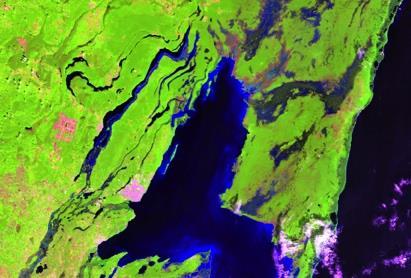
1 International Partnership Space Programme Earth Observation for the Preservation of Ecological Bacalar Corridor Platform and Products Terri Freemantle, Raffaella Guida, Paula Marti, Pasquale Iervolino and Steve Spittle ERIS workshop Chetumal, 1 December 2015


2 An end-user driven Process Collection of end-users requirements Definition of platform functionalities Definition of products
3 The Platform
 and non- EO data alongside various processing and analytical")
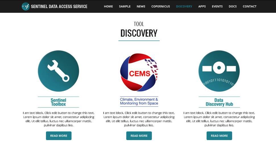
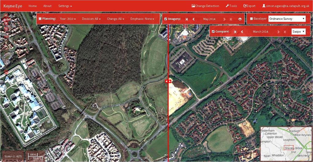
4 Climate and Environmental Monitoring from Space (CEMS) Cloud Computing Environment 3 Main Functions: Community Cloud High Performance Computing Data Sharing To provide access to a wide range of climate, Earth Observation (EO) and non- EO data alongside various processing and analytical tools
 Hosting")

5 CEMS Architecture Scalable and secure infrastructure Configurable virtual machines The within total privately combined managed resource: virtual 340+ CPU data cores centres (>1400 Ghz) Hosting applications, 6TB of RAM public facing 1.3PB web of attached portals and storage development environments. High Performance Computing for CPU intensive processing jobs, such as archiving satellite mission data.


6 CEMS Satellite Data and Resources Access to Data Catalogue of free spatial and non-spatial data EO database 10Gb connection


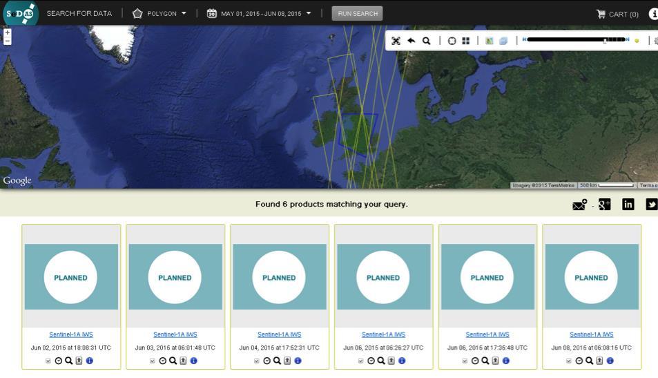
7 CEMS Sentinel Data Access Service UK Collaborative Ground Segment holds rolling archive of Sentinel data


8 IPSP Bacalar Monitoring Platform Overview 1 Provide ease of use within the browser Maximise visual aspects of the data whilst maintaining data integrity and rendering time Include authentication system to limit access to specified users Provide free and open source Spatial Data Infrastructure


9 IPSP Bacalar Monitoring Platform Overview 2 Map based interface On the fly image processing using CEMS CPU GIS functionality including data querying, creation of shapefiles etc. Direct access to database, allowing upload and download of datasets
10 Potential further developments for the IPSP Bacalar Monitoring Platform 1. Future Cities

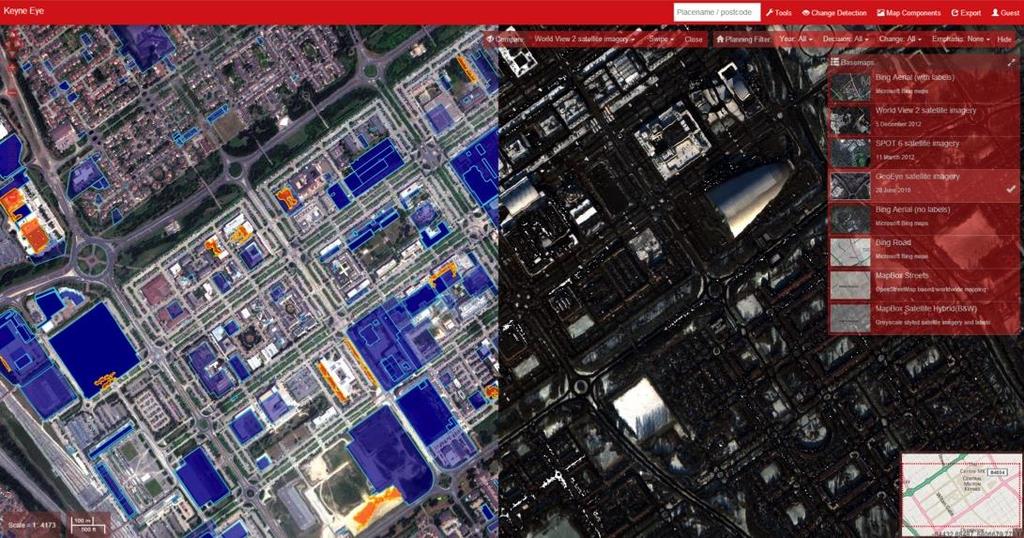
11 Working With Local Authorities: Urban Development 18/01/2016

12 Not yet implemented in the beta version of the Bacalar Platform Platform will be able to clearly visualise change between two satellite images 18/01/2016
13 The Products


14 Priorities Human activities - Land cover change between 2005 and Urban growth map between 2005 and 2015 Water Quality -Water quality maps of Chetumal Bay -Bathymetry map of Chetumal Bay Mangrove Ecosystem -Mangrove Distribution Map -Flooding extent in coastal mangroves -Mangrove degradation map post Hurricane Dean
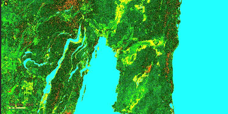
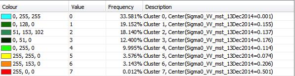
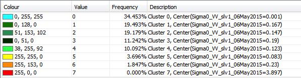
")


15 Satellite Derived Bathymetry RapidEye (5m) RapidEye (5m) Relative Water Depth created using bottom albedo-independent Bathymetry algorithm

16 Satellite Derived Bathymetry Catapult Overview Catapult Overview Earth Catapult Observation Overview Products for IPSP Bacalar Project Earth Observation Products for IPSP Bacalar Project Earth Bathymetry Observation Products for IPSP Bacalar Project Bathymetry Mapping Bathymetry mangrove distribution and Mapping mangrove distribution and degradation Mapping mangrove distribution and degradation Water degradation Quality Water Quality Platforms Water Quality Platforms Platforms CEMS Infrastructure CEMS Infrastructure Bacalar CEMS Monitoring Infrastructure Platform Bacalar Monitoring Platform Example Bacalar of Monitoring Urban change Platform detection platform Example of Urban change detection platform Example of Urban change detection platform Landsat 8 30m


17 Mapping mangrove distribution and degradation Catapult Overview Catapult Overview Earth Catapult Observation Overview Products for IPSP Bacalar Project Earth Observation Products for IPSP Bacalar Project Earth Bathymetry Observation Products for IPSP Bacalar Project Bathymetry Mapping Bathymetry mangrove distribution and Mapping mangrove distribution and degradation Mapping mangrove distribution and degradation Water degradation Quality Water Quality Platforms Water Quality Platforms Platforms CEMS Infrastructure CEMS Infrastructure Bacalar CEMS Monitoring Infrastructure Platform Bacalar Monitoring Platform Example Bacalar of Monitoring Urban change Platform detection platform Example of Urban change detection platform Example of Urban change detection platform Terri, are you going to add something here? - We do not currently have any products, I can add an example or leave it blank? Cornforth et al (2013) Advanced Land Observing Satellite Phased Array Type L-Band SAR (ALOS PALSAR) to Inform the Conservation of Mangroves: Sundarbans as a Case Study


18 Water Quality in Laguna Bacalar and Chetumal Bay RapidEye (5m) 2010 Normalised Turbidity Index

19 Evapotranspiration Weekly water demand for fruit trees o o Local and global water demand for Arica (Chile) calculated from evapotranspiration over several weeks The maps show the water demand dropped from week 1 to week 9 and this was due to a drop in the temperatures week1 week4 week7 week9


20 Land Use CropID A map of UK vegetable crops Start with satellite imagery and field boundaries Apply software algorithms using a machine learning approach The result is the most probable crop in each field


21 Land Cover Corredor Transversal Costero, Chetumal Start with satellite imagery Rough classification Further processing reveals the differences on the land cover RapidEye 2010 True colour image Unsupervised classification Ground data will help analysis
 - Comparison of DEIMOS- 1 2010 data with Google Earth")
22 Change Detection Deforestation areas in Brazil - Detection of recent deforestation areas in Rondonia (Brazil) - Comparison of DEIMOS data with Google Earth database.


23 Forestry Analysis of impact after a fire Step 1: Multi-temporal analysis (false color) Step 2: Perimeter identification Step 3: Analysis Unburned Burned Perimeter: 9.7 km Area: 138,873 acres Perimeter: 71.4 km Area: 1,960,912 acres


24 SAR in change detection Sentinel-1 datasets 13 Dec May 2015 Parameter Sensor Mode Polarization Product Spatial Resolution Value Sentinel-1 IWS VV GRD 10 x 10 m

25 SAR in change detection Sentinel-1 datasets 13 Dec May 2015


26 SAR in change detection TerraSAR-X datasets 11 Feb 2011 Parameter Sensor Mode Polarization Product Spatial Resolution Value TerraSAR-X Spotlight HH SLC 0.9 x 0.5 m


27 Surface Water Quality with SAR Oil10 HH S-band X-band Crude oil Diesel oil Look-alikes Fused image (Db1_1max)

 Spatial gap among datasets (can we use datasets presenting")
 Information diversity among datasets (how to put together")
28 Land cover mapping with Data Fusion Panchromatic Temporal gap among acquisitions (can we use datasets acquired at different times?) Spatial gap among datasets (can we use datasets presenting different resolution and coverage?) Information diversity among datasets (how to put together information from Radar Cross Section and Reflectivity curves?) SAR Multispectral LiDAR

 Sea Pools Bare soil Sand Trees Shrubs Grass SAR+LiDAR Buildings Roads Shadows")
29 Land cover mapping with Data Fusion Lake Sea Pools Bare soil Sand Sea green Trees Shrubs Grass SAR+Multispectral+Panchromatic Buildings Roads Shadows or not classified Overall accuracy: 85.53% (78.74% Multispectral only, 83.20% Multi+Pan) Sea Pools Bare soil Sand Trees Shrubs Grass SAR+LiDAR Buildings Roads Shadows or not classified Overall accuracy: 85.16% (71.09% LiDAR only)
30 Gracias!
COSMO-Coast. L Aquila. La Sapienza. Tor Vergata. Dipartimento di Architettura ed Urbanistica. Dipartimento di Informatica, Sistemi e Produzione,
 COSMO-Coast Tor Vergata Dipartimento di Informatica, Sistemi e Produzione, L Aquila Dipartimento di Architettura ed Urbanistica La Sapienza Dipartimento Ingegneria Civile, Edile ed Ambientale Introduction
Retreating Glaciers of the Himalayas: A Case Study of Gangotri Glacier Using Satellite Images
 Retreating Glaciers of the Himalayas: A Case Study of Gangotri Glacier Using 1990-2009 Satellite Images Jennifer Ding Texas Academy of Mathematics and Science (TAMS) Mentor: Dr. Pinliang Dong Department
SCRAMJET. Mapping and monitoring airports with Sentinel 1 and 2 data
 SCRAMJET Mapping and monitoring airports with Sentinel 1 and 2 data 18/03/2018 GISTAM 2018 Urban geospatial mapping for the SCRAMJET business networking tool Nuno Duro, Pedro Coutinho, Gil Gonçalves Index
Turbulence Data Sharing Project. Katya Vashchankova Head, IATA Meteorological (MET) Program
 Program") Turbulence Data Sharing Project Katya Vashchankova Head, IATA Meteorological (MET) Program 1 Turbulence is The leading cause of injuries to cabin crew and passengers in non-fatal accidents (FAA) Costing
Turbulence Data Sharing Project Katya Vashchankova Head, IATA Meteorological (MET) Program 1 Turbulence is The leading cause of injuries to cabin crew and passengers in non-fatal accidents (FAA) Costing
EO-based services to support humanitarian operations: monitoring population and natural resources in refugee/idp camps
 How satellites can help to save lives Vienna, Austria 23 February 2016 EO-based services to support humanitarian operations: monitoring population and natural resources in refugee/idp camps Petra FÜREDER
Coverage of Mangrove Ecosystem along Three Coastal Zones of Puerto Rico using IKONOS Sensor
 Coverage of Mangrove Ecosystem along Three Coastal Zones of Puerto Rico using IKONOS Sensor Jennifer Toledo Rivera Geology Department, University of Puerto Rico, Mayagüez Campus P.O. Box 9017 Mayagüez,
DETECTION OF ICE FRONT INITIATION ON THE PEACE RIVER IN NORTHERN ALBERTA Freeze-up
 FINAL REPORT DETECTION OF ICE FRONT INITIATION ON THE PEACE RIVER IN NORTHERN ALBERTA Freeze-up 2013-2014 REFERENCE NO. CO 73797 Presented to: British Columbia Hydro and Power Authority Prepared by: Monique
Optimizing trajectories over the 4DWeatherCube
 Optimizing trajectories over the 4DWeatherCube Detailed Proposal - SES Awards 2016 Airbus Defence and Space : dirk.schindler@airbus.com Luciad : robin.houtmeyers@luciad.com Eumetnet : kamel.rebai@meteo.fr
Integrated Applications Programme (IAP) & Space for UAS UAS for Applications
 & Space for UAS UAS for Applications") ESA s Integrated Applications Programme (IAP) & Space for UAS UAS for Applications M. Vaissiere ESA Director of Telecommunications and Integrated Applications Programme European High Level UAS Conference
ESA s Integrated Applications Programme (IAP) & Space for UAS UAS for Applications M. Vaissiere ESA Director of Telecommunications and Integrated Applications Programme European High Level UAS Conference
GEOSPATIAL ANALYSIS OF GLACIAL HAZARDS PRONE AREAS OF SHIGAR AND SHAYOK BASINS OF PAKISTAN. By Syed Naseem Abbas Gilany
 GEOSPATIAL ANALYSIS OF GLACIAL HAZARDS PRONE AREAS OF SHIGAR AND SHAYOK BASINS OF PAKISTAN By Syed Naseem Abbas Gilany PRESENTATION OUTLINE Introduction Problem Statement / Rationale Objectives Material
Investigation on Development of Agricultural Monitoring System Using Satellite Data
 Investigation on Development of Agricultural Monitoring System Using Satellite Data Genya SAITO (1), Daisuke KUNII (1), Naoki ISHITSUKA (2) (1) Tohoku University, 1-1,Tsutsumidori Amamiya-machi Aoba-ku,
A high resolution glacier model with debris effects in Bhutan Himalaya. Orie SASAKI Kanae Laboratory 2018/02/08 (Thu)
") A high resolution glacier model with debris effects in Bhutan Himalaya Orie SASAKI Kanae Laboratory 2018/02/08 (Thu) Research flow Multiple climate data at high elevations Precipitation, air temperature
A high resolution glacier model with debris effects in Bhutan Himalaya Orie SASAKI Kanae Laboratory 2018/02/08 (Thu) Research flow Multiple climate data at high elevations Precipitation, air temperature
LAUNCHING YOUR UNMANNED AIRCRAFT PROGRAM
 LAUNCHING YOUR UNMANNED AIRCRAFT PROGRAM THE DARTDRONES TEAM UNMANNED AIRCRAFT APPLICATIONS AERIAL INSPECTIONS AERIAL INSPECTIONS Safer and faster alternative to visual inspection by an individual Damage
Enabling Civilian Low-Altitude Airspace and Unmanned Aerial System (UAS) Operations. Unmanned Aerial System Traffic Management (UTM)
 Operations. Unmanned Aerial System Traffic Management (UTM)") Enabling Civilian Low-Altitude Airspace and Unmanned Aerial System (UAS) Operations By Unmanned Aerial System Traffic Management (UTM) Parimal Kopardekar, Ph.D. UTM Principal Investigator and Manager,
Enabling Civilian Low-Altitude Airspace and Unmanned Aerial System (UAS) Operations By Unmanned Aerial System Traffic Management (UTM) Parimal Kopardekar, Ph.D. UTM Principal Investigator and Manager,
EO technologies for flood mapping and hydrological modelling in Namibia
 Satellite Earth Observation & Disaster Risks EO technologies for flood mapping and hydrological modelling in Namibia Guido Van Langenhove, Hydrological Services Namibia Hydrological trends in Namibia:
Japan Earthquake and Tsunami: a view from satellite data
 Università degli studi di Roma Tor Vergata Corso di Telerilevamento e Cartografia Anno accademico 2012/2013 Japan Earthquake and Tsunami: a view from satellite data Dr. Matteo Picchiani picchiani@disp.uniroma2.it
Regional implementation of Electronic Terrain and Obstacle data (e-tod) (Presented by Jeppesen)
 (Presented by Jeppesen)") International Civil Aviation Organization SAM/IG/13-WP/39 South American Regional Office 5/04/14 Thirteenth Workshop/Meeting of the SAM Implementation Group English only (SAM/IG/13) - Regional Project
International Civil Aviation Organization SAM/IG/13-WP/39 South American Regional Office 5/04/14 Thirteenth Workshop/Meeting of the SAM Implementation Group English only (SAM/IG/13) - Regional Project
David Controle, Analytics Accelerator Airbus. Why Invest in AI and Deep Learning NVIDIA GTC
 David Controle, Analytics Accelerator Airbus Why Invest in AI and Deep Learning NVIDIA GTC Punctuality issue 20 % flights delayed more than 15 min * 50 min average delay * 57 % airlines experience frequent
Unmanned Aircraft Systems (UAS) at the Jornada Experimental Range
 at the Jornada Experimental Range") Unmanned Aircraft Systems (UAS) at the Jornada Experimental Range Al Rango and the Jornada UAS Flight Team: Connie Maxwell, Amy Slaughter, Andrea Laliberte, Chris Pierce, Dave Thatcher, Jim Lenz, and Craig
Unmanned Aircraft Systems (UAS) at the Jornada Experimental Range Al Rango and the Jornada UAS Flight Team: Connie Maxwell, Amy Slaughter, Andrea Laliberte, Chris Pierce, Dave Thatcher, Jim Lenz, and Craig
DriDanube. Drought Risk in the Danube Region. Department of Geodesy and Geoinformation (GEO) Vienna University of Technology (TU Wien)
 Vienna University of Technology (TU Wien)") DriDanube Drought Risk in the Danube Region Department of Geodesy and Geoinformation (GEO) Vienna University of Technology (TU Wien) Vienna, 4 April 2018 DriDanube Drought Risk in the Danube Region Project
DriDanube Drought Risk in the Danube Region Department of Geodesy and Geoinformation (GEO) Vienna University of Technology (TU Wien) Vienna, 4 April 2018 DriDanube Drought Risk in the Danube Region Project
Applying Geospatial Tools to Produce Data for SDG Indicators in Mexico
 Applying Geospatial Tools to Produce Data for SDG Indicators in Mexico Inter-Agency and Expert Group On SDGs Indicators Enrique Ordaz Francisco J. Jimenez Stockholm November 2018 Background INEGI has produced
Monitoring & Control Tim Stevenson Yogesh Wadadekar
 Monitoring & Control Tim Stevenson Yogesh Wadadekar Monitoring & Control M&C is not recognised as an SPDO Domain However the volume of work carried out in 2011 justifies a Concept Design Review M&C is
Robson Valley Avalanche Tract Mapping Project
 Robson Valley Avalanche Tract Mapping Project Prepared for: Chris Ritchie Ministry of Water Land and Air Protection 325 1011 4th Avenue Prince George, BC. V2L3H9 and Dale Seip Ministry of Forests 1011
Figure Pre- and post-disaster satellite topographical maps
 2.1.3 Image analysis by JAXA JAXA conducted ongoing emergency observations using Daichi in the wake of the Great East Japan Earthquake, releasing reporting of its analysis of eastern Japan and Hokkaido
Glacial lakes as sentinels of climate change in Central Himalaya, Nepal
 Glacial lakes as sentinels of climate change in Central Himalaya, Nepal Sudeep Thakuri 1,2,3, Franco Salerno 1,3, Claudio Smiraglia 2,3, Carlo D Agata 2,3, Gaetano Viviano 1,3, Emanuela C. Manfredi 1,3,
ReefFix. May, For the Organization of American States (OAS) and the Inter-American Biodiversity Information Network (IABIN)
 and the Inter-American Biodiversity Information Network (IABIN)") Fondation pour la Protection de la Biodiversité Marine FoProBiM B.P. 642 www.foprobim.org (mail) 6011 Henning St. Port-au-Prince, Haiti Bethesda, MD 20817 ReefFix Rapid Assessment of the Economic Value
Fondation pour la Protection de la Biodiversité Marine FoProBiM B.P. 642 www.foprobim.org (mail) 6011 Henning St. Port-au-Prince, Haiti Bethesda, MD 20817 ReefFix Rapid Assessment of the Economic Value
Surveillance and Broadcast Services
 Surveillance and Broadcast Services Benefits Analysis Overview August 2007 Final Investment Decision Baseline January 3, 2012 Program Status: Investment Decisions September 9, 2005 initial investment decision:
Ocho Rios, Jamaica GEF-IWCAM AND IABIN INDICATORS MECHANISM WORKSHOP March TNC s Marine Protected Area Work.
 TNC s Marine Protected Area Work in the Caribbean GEF-IWCAM AND IABIN INDICATORS MECHANISM WORKSHOP 10-12 March 2008 Ocho Rios, Jamaica Caribbean Decision-Support System 3 years (2003-2006) $2.2 million
A SEGMENTED ARCHITECTURE APPROACH TO PROVIDE A CONTINUOUS, LONG-TERM, ADAPTIVE AND COST- EFFECTIVE GLACIERS MONITORING SYSTEM
 1st IAA Latin American Symposium on Small Satellites: Advanced Technologies and Distributed Systems A SEGMENTED ARCHITECTURE APPROACH TO PROVIDE A CONTINUOUS, LONG-TERM, ADAPTIVE AND COST- EFFECTIVE GLACIERS
Ground Deformation Monitoring at Natural Gas Production Sites using Interferometric SAR
 Ground Deformation Monitoring at Natural Gas Production Sites using Interferometric SAR By: Kanika Goel, Robert Shau, Fernando Rodriguez Gonzalez, Nico Adam Remote Sensing Technology Institute (IMF), German
Mikaela Weisse Scott Kloeck-Jenson Fellowship report Travel Award (2014) Lima, Peru
 Lima, Peru") Mikaela Weisse Scott Kloeck-Jenson Fellowship report Travel Award (2014) Lima, Peru I received a Scott Kloeck-Jenson fellowship to complete an international internship during the summer of 2014. I spent
Mikaela Weisse Scott Kloeck-Jenson Fellowship report Travel Award (2014) Lima, Peru I received a Scott Kloeck-Jenson fellowship to complete an international internship during the summer of 2014. I spent
Using of space technologies for glacierand snow- related hazards studies
 United Nations / Germany international conference on International Cooperation Towards Low-Emission and Resilient Societies Using of space technologies for glacierand snow- related hazards studies Bonn,
UAS to GIS Utilizing a low-cost Unmanned Aerial System (UAS) for Coastal Erosion Monitoring
 for Coastal Erosion Monitoring") UAS to GIS Utilizing a low-cost Unmanned Aerial System (UAS) for Coastal Erosion Monitoring Agenda Scope of today s presentation Demonstration Objectives Wrightsville Beach Test Area Masonboro Inlet Jetties
UAS to GIS Utilizing a low-cost Unmanned Aerial System (UAS) for Coastal Erosion Monitoring Agenda Scope of today s presentation Demonstration Objectives Wrightsville Beach Test Area Masonboro Inlet Jetties
From AIS To AIM. Agenda. Agenda. Jack Hsu Mark Varellas
 Agenda Agenda From AIS To AIM 1. Introduction to MDA 2. What is AIS to AIM? 3. FAA Approach to AIM 4. AIM Transition Planning 5. ext Steps 1. Introduction to MDA 2. What is AIS to AIM? 3. FAA Approach
PDC Members. Charter Members. Technology & Honorary Members. There is clearly a cross over 5/31/2017
 UAS A Tool for Commercial and Government Application Partnership SCARC 2017 Charles Mondello Eagleview Stategist & President Property Drone Consortium 1 The PDC is a consortium among insurance carriers,
Monitoring of Mountain Glacial Variations in Northern Pakistan, from 1992 to 2008 using Landsat and ALOS Data. R. Jilani, M.Haq, A.
 Monitoring of Mountain Glacial Variations in Northern Pakistan, from 1992 to 2008 using Landsat and ALOS Data R. Jilani, M.Haq, A. Naseer Pakistan Space & Upper Atmosphere Research Commission (SUPARCO)
Intra-Urban Land Cover Classification in High Spatial Resolution Images using Object-Oriented Analysis: trends and challenges
 Intra-Urban Land Cover Classification in High Spatial Resolution Images using Object-Oriented Analysis: trends and challenges Carolina Moutinho Duque de Pinho carolina@dpi.inpe.br Introduction What is
EVALUATION OF DIFFERENT METHODS FOR GLACIER MAPPING USING LANDSAT TM
 EVALUATION OF DIFFERENT METHODS FOR GLACIER MAPPING USING LANDSAT TM Frank Paul Department of Geography, University of Zurich, Switzerland Winterthurer Strasse 190, 8057 Zürich E-mail: fpaul@geo.unizh.ch,
Monitoring the Environmental Status of the Heart of Borneo
 Monitoring the Environmental Status of the Heart of Borneo By: Stephan Wulffraat The Heart of Borneo conservation initiative has been going on now for several years and has gained increasing support from
Time Series Evapotranspiration Mapping Using Landsat-TM and MODIS Data
 United States Department of Agriculture Time Series Evapotranspiration Mapping Using Landsat-TM and MODIS Data Agricultural Research Service SOIL & WATER MANGEMENT RESEARCH George Paul Prasanna Gowda Xiangming
UAV Flight Services Company. What We Do. What Sets us Apart
 UAV Flight Services Company A dedicated team of aviators, technologists, and engineers. What We Do UAV flight services for data collection, mapping, and inspection What Sets us Apart Extensive field experience,
Hosted Flight Data Monitoring. Information Sheet
 17 Wellington Business Park Crowthorne Berkshire RG45 6LS England Tel: +44 (0) 1344 234047 www.flightdatapeople.com Hosted Flight Data Monitoring Information Sheet www.flightdatapeople.com Commercial in
Appalachian Trail Sustainability Research Study
 Appalachian Trail Sustainability Research Study Appalachian National Scenic Trail 2,175 mile footpath from Maine to Georgia Crosses 14 states, 6 NPS units, and 8 National Forests, Managed by the NPS A.T.
ENVIRONMENT ACTION PLAN
 ENVIRONMENT ACTION PLAN 2015 16 Airservices Australia 2015 This work is copyright. Apart from any use as permitted under the Copyright Act 1968, no part may be reproduced by any process without prior written
Index. Springer International Publishing AG 2018 I. Schagaev, B.R. Kirk, Active System Control, DOI /
 Index A Active black box, 286 287 Active real-time reliability, 272 Active system control (ASC), 212, 221, 231 ACSCU, 243 active, 45 aircraft classification, 270 aircraft model, 193 algorithm, 250, 252,
Definitions. U-SAFE : UAS Secure Autonomous Flight Environment. UTM: UAS Traffic Management
 Definitions U-SAFE : UAS Secure Autonomous Flight Environment UTM: UAS Traffic Management NUSTAR: National UAS Standardized Test and Rating 2 U-SAFE Award Dec 11, 2015 Signature Initiative in Central New
Establishing a Risk-Based Separation Standard for Unmanned Aircraft Self Separation
 Establishing a Risk-Based Separation Standard for Unmanned Aircraft Self Separation Roland E. Weibel, Matthew W.M. Edwards, and Caroline S. Fernandes MIT Lincoln laboratory Surveillance Systems Group Ninth
IAC 2011 Cape Town, October th
 Cape Town, October 05 05 th Project Partners External Supporters and Sponsors The Problem The Solution Overview S 2 BAS Concept of Operations Architecture Possible Applications Stakeholders Flight Phases
Cal/Val Activities at the CIGSN Uardry Field Site, NSW, Australia in Support of the EO-1 Mission
 Cal/Val Activities at the CIGSN Uardry Field Site, NSW, Australia in Support of the EO-1 Mission Fred Prata and Graham Rutter CSIRO Atmospheric Research David Jupp CSIRO Earth Observation Centre EOC Annual
Global Aviation Data Management (GADM) Jehad Faqir Head of Safety & Flight Operations IATA- MENA
 Jehad Faqir Head of Safety & Flight Operations IATA- MENA") Global Aviation Data Management (GADM) Jehad Faqir Head of Safety & Flight Operations IATA- MENA Safety Management Workshop Kuwait, 25-27 May, 2015 Global Aviation Data Management The way forward is to
Global Aviation Data Management (GADM) Jehad Faqir Head of Safety & Flight Operations IATA- MENA Safety Management Workshop Kuwait, 25-27 May, 2015 Global Aviation Data Management The way forward is to
Waukegan & Calumet Rivers. All Hands Meeting
 Waukegan & Calumet Rivers 516(e) Update All Hands Meeting David F. Bucaro, P.E. Chief, Economic Formulation & Analysis Section, Planning Branch May 18 th, 2011 Kensington Court Ann Arbor, MI 1 2 Waukegan
AIRPORTS GIS UPDATE. Federal Aviation Administration. https://airports-gis.faa.gov/
 AIRPORTS GIS UPDATE Presented to ACC Airports Technical Workshop Presented by John R. Dermody, Manager, Airport Engineering Division Date July 29, 2014 1 Airports GIS Update 1. AGIS Overview 2. NAV Lean
ICTAP Program. Interoperable Communications Technical Assistance Program. Communication Assets Survey and Mapping (CASM) Tool Short Introduction
 Tool Short Introduction") ICTAP Program Interoperable Communications Technical Assistance Program Communication Assets Survey and Mapping (CASM) Tool Short Introduction Outline Overview General Information Purpose Security Usage
ICTAP Program Interoperable Communications Technical Assistance Program Communication Assets Survey and Mapping (CASM) Tool Short Introduction Outline Overview General Information Purpose Security Usage
EUROCONTROL. Centralised Services concept. Joe Sultana Director Network Manager 1 July 2013
 EUROCONTROL Centralised Services concept Joe Sultana Director Network Manager 1 July 2013 EUROCONTROL Centralised Services 2 Why do we need Centralised Services? Europe needs to be competitive again! a
In-field and Remote Sensing for Precision Agriculture. John Nowatzki Extension Ag Machine Systems Specialist North Dakota State University
 In-field and Remote Sensing for Precision Agriculture John Nowatzki Extension Ag Machine Systems Specialist North Dakota State University UAS in Precision Agriculture In-field Sensors Selecting UAS Equipment
Space Based ADS-B. ICAO SAT meeting - June 2016 AIREON LLC PROPRIETARY INFORMATION
 Space Based ADS-B ICAO SAT meeting - June 2016 1 Options to Detect an Aircraft Position Position Accuracy / Update Interval Voice Position Reporting ADS-C Position Reporting Radar Surveillance / MLAT Space
S 2 BAS Space Services Benefits in Aviation Systems. 2 nd ARTES Applications Workshop April 19 th, 2012 Harwell, UK
 S 2 BAS Space Services Benefits in Aviation Systems April 19 th, 2012 Harwell, UK General Aviation and Business traffic will expand in the near future (4-6% per year. Source: Eurocontrol, 2011) Regional
Ground movement safety systems and procedures - an overview
 Ground movement safety systems and procedures - an overview Thorsten Astheimer, Fraport AG Airside System Development Purpose of Surface Movement Guidance Systems Definition of A-SMGCS Levels (ICAO): 1)
Integration Of Reflectance To Study Glacier Surface Using Landsat 7 ETM+: A Case Study Of The Petermann Glacier In Greenland
 Integration Of Reflectance To Study Glacier Surface Using Landsat 7 ETM+: A Case Study Of The Petermann Glacier In Greenland Félix O. Rivera Santiago Department Of Geology, University Of Puerto Rico, Mayaguez
Observations of glacier dynamics with PALSAR DATA
 Observations of glacier dynamics with PALSAR DATA Tazio Strozzi, Urs Wegmüller and Charles Werner Gamma Remote Sensing, Gümligen, Switzerland Rhodes, Greece, 3 to 7 November 2008 Outline ESA GLOBGLACIER
USE OF 3D GIS IN ANALYSIS OF AIRSPACE OBSTRUCTIONS
 USE OF 3D GIS IN ANALYSIS OF AIRSPACE OBSTRUCTIONS A project by by Samuka D. W. F19/1461/2010 Supervisor; Dr D. N. Siriba 1 Background and Problem Statement The Airports in Kenya are the main link between
MARINE PROTECTED AREAS LESSON PLAN Water Parks
 Marine Protected Areas U. S. Marine Protected Areas Lesson Plan MARINE PROTECTED AREAS LESSON PLAN Water Parks Theme U.S. Marine Protected Areas Links to Overview Essays and Resources Needed for Student
Urban Climate Change Research Network and ARC3.2
 Urban Climate Change Research Network and ARC3.2 1 UCCRN Mission Provide knowledge that enables cities and metropolitan regions to fulfill their climate change leadership potential in both mitigation and
Airborne Remote Sensing Component of Marine Debris Monitoring
 Airborne Remote Sensing Component of Marine Debris Monitoring Dr. Thomas H Mace Mace Geospatial, LLC Workshop on Mission Concepts for Marine Debris Sensing Honolulu, Hi, Jan 19 21, 2016 Multistage Remote
National Protected Area Systems Analysis Case Study: Gra Gra Lagoon National Park
 ational Protected Area ystems Analysis Case tudy: Gra Gra Lagoon ational Park Problem statement: How does Gra Gra Lagoon ational Park fit in the ational Protected Areas ystem and how does it relate to
Water Quality Monitoring and Validation from NOAA operational satellite sensor (VIIRS) Data Products in Coral Reef Environments
 Data Products in Coral Reef Environments") Water Quality Monitoring and Validation from NOAA operational satellite sensor (VIIRS) Data Products in Coral Reef Environments William J Hernandez, Ph.D 1, 4 Post-Doctoral Researcher Roy A. Armstrong
Water Quality Monitoring and Validation from NOAA operational satellite sensor (VIIRS) Data Products in Coral Reef Environments William J Hernandez, Ph.D 1, 4 Post-Doctoral Researcher Roy A. Armstrong
Real-time route planning streamlines onboard operations, reduces fuel burn and delays, and improves on-time performance.
 Real-time route planning streamlines onboard operations, reduces fuel burn and delays, and improves on-time performance. Operational Efficiency of Dynamic Navigation Charting Benefits such as improved
Lidar Imagery Reveals Maine's Land Surface in Unprecedented Detail
 Maine Geologic Facts and Localities December, 2011 Lidar Imagery Reveals Maine's Land Surface in Unprecedented Detail Text by Woodrow Thompson, Department of Agriculture, Conservation & Forestry 1 Introduction
WEBINAR: A BIRD S-EYE VIEW
 WEBINAR: A BIRD S-EYE VIEW DRONES IN AGRIBUSINESS JUNE 21, 2016 Hosted by Nexsen Pruet Presented by Ernie Pearson (Nexsen Pruet); Patrick Lohman (PrecisionHawk); and Kyle Snyder (NGAT/NCSU) FOUNDED IN
Runway Roughness Evaluation- Boeing Bump Methodology
 FLIGHT SERVICES Runway Roughness Evaluation- Boeing Bump Methodology Michael Roginski, PE, Principal Engineer Boeing Airport Compatibility Engineering ALACPA XI Seminar, Santiago, Chile September 1-5,
Overview ICAO Standards and Recommended Practices for Aerodrome Mapping Data reported to AIM
 Overview ICAO Standards and Recommended Practices for Aerodrome Mapping Data reported to AIM References ICAO SARPS Annex 14 Vol. I, 7 th Edition, July 2016 ICAO SARPS Annex 15, 15 th Edition, July 2016
Deepwater Horizon Oil Spill Principal Investigator One Year Update Workshop
 Deepwater Horizon Oil Spill Principal Investigator One Year Update Workshop Wave Glider Monitoring the Gulf of Mexico Graham Hine Senior Vice President of Operations Liquid Robotics, Inc. 25 October, 2011
Table of Content. Table of Contents Mobile Experts LLC. All Rights Reserved. 1
 Table of Content Table of Contents 2015 Mobile Experts LLC. All Rights Reserved. 1 Table of Content List of Figures... 5 List of Tables... 9 Executive Summary...11 Synopsis of C-RAN Developments in the
DATA MANAGEMENT & CONNECTED SOLUTIONS
 DATA MANAGEMENT & CONNECTED SOLUTIONS The flight data journey Solutions to help improve operations efficiency COLLECT YOUR FLIGHT DATA PUT YOUR FLIGHT DATA TO WORK Data Acquisition Data Transfer Data management
Using PBN for Terminal and Extended Terminal Operations
 Using PBN for Terminal and Extended Terminal Operations Navigation Performance Data Analysis and its Effect on Route Spacing Dijana Trenevska EUROCONTROL 27 June 2017 Content Background and Objective Data
Global Runway Safety Simposium
 Global Runway Safety Simposium A DIFFERENT PERSPECTIVE OF SAFETY AND ITS RELATIONSHIP WITH SURROUNDINGS Costantino Pandolfi LIMA, 11/21/2017 Italian Civil Aviation Authority ICAO ADOP Member Panel 8 New
CITY OF LYNDEN STORMWATER MANAGEMENT PROGRAM REPORT MARCH 1, 2016
 CITY OF LYNDEN STORMWATER MANAGEMENT PROGRAM 2015 WATER QUALITY MONITORING REPORT CITY OF LYNDEN 300 4 TH STREET LYNDEN, WASHINGTON 98264 PHONE (360) 354-3446 MARCH 1, 2016 This document serves as an attachment
KGP 560. Enhanced Ground Proximity Warning System for General Aviation SEAMLESS SAFETY INTEGRATION THROUGH IHAS
 KGP 560 Enhanced Ground Proximity Warning System for General Aviation SEAMLESS SAFETY INTEGRATION THROUGH IHAS KGP 560 GA-EGPWS Depicted here on the KMD 850 Multi-Function Display T HE H AZARD OF CFIT
AUGUST 2017 GNSS REVIEW. Survey Economics Chances of success. Mobile Mapping Airport scanning. Stag s Leap Winery Pre-construction plan
 AUGUST 2017 GNSS REVIEW Survey Economics Chances of success Stag s Leap Winery Pre-construction plan Mobile Mapping Airport scanning RISING PERFORMANCE» ERIK DAHLBERG Civil aviation is an outlier. It s
AIXM Annual Conference 2008 Day 2 March 19 th (morning) Migration TO and FROM AIXM from other AMDB Formats. Alan Poole/Dejan Damjanovic
 Migration TO and FROM AIXM from other AMDB Formats. Alan Poole/Dejan Damjanovic") AIXM Annual Conference 2008 Day 2 March 19 th (morning) Migration TO and FROM AIXM from other AMDB Formats Alan Poole/Dejan Damjanovic Overview Background and Problem Definitions. IATA AIS Data Pool Vision.
AIXM Annual Conference 2008 Day 2 March 19 th (morning) Migration TO and FROM AIXM from other AMDB Formats Alan Poole/Dejan Damjanovic Overview Background and Problem Definitions. IATA AIS Data Pool Vision.
RISING PERFORMANCE. Civil aviation is an outlier. It s BY ERIK DAHLBERG
 RISING PERFORMANCE Compact mobile mapping systems can be installed on small passenger cars. Civil aviation is an outlier. It s among the few industries where tight government regulations are widely accepted
AI in a SMART AIrport
 AI in a SMART AIrport Steve Lee CIO & Group SVP(Technology) Changi Airport Group (Singapore) Pte. Ltd. 24 Oct 2017 2017 Changi Airport Group (Singapore) Pte. Ltd. Not to be used, disclosed or reproduced
DANUBE FAB real-time simulation 7 November - 2 December 2011
 EUROCONTROL DANUBE FAB real-time simulation 7 November - 2 December 2011 Visitor Information DANUBE FAB in context The framework for the creation and operation of a Functional Airspace Block (FAB) is laid
Baltic Sea Hydrographic Commission, Bathymetric Database and the MONALISA project. - with co-financing from EU TEN-T SJÖFARTSVERKET
 SJÖFARTSVERKET Baltic Sea Hydrographic Commission, Presentation vid dialogmöte Kommunikationer för tillväxt Centerpartiet Östergötland, 25 oktober 2011 Magnus Sundström Bathymetric Database and the MONALISA
HIMIOFoTS - Hellenic Integrated Marine Inland water Observing, Forecasting and offshore Technology System
 HIMIOFoTS - Hellenic Integrated Marine Inland water Observing, Forecasting and offshore Technology System Leonidas Perivoliotis, Institute of Oceanography, Hellenic Center for Marine Research HIMIOFOTS
The next generation of in-flight, real-time 3-D moving maps. Airshow 4000 MOVING MAPS
 The next generation of in-flight, real-time 3-D moving maps. Airshow 4000 MOVING MAPS Stay engaged and aware in the air. In today s world, things happen faster than ever. You can t afford to be out of
Table of Contents 2015 Mobile Experts LLC. All Rights Reserved. 1
 Table of Contents 2015 Mobile Experts LLC. All Rights Reserved. 1 List of Figures... 5 List of Tables... 8 Executive Summary... 9 Synopsis of C-RAN Developments in the Past Year (2014)... 13 Drivers of
Engineering With Nature Geographic Project Mapping Tool (EWN ProMap)
") Engineering With Nature Geographic Project Mapping Tool (EWN ProMap) Cynthia Banks Program Manager Burton Suedel, PhD Research Biologist Michelle Bourne Research Biologist U.S. Army ERDC 23 June 2015 Dredging
Engineering With Nature Geographic Project Mapping Tool (EWN ProMap) Cynthia Banks Program Manager Burton Suedel, PhD Research Biologist Michelle Bourne Research Biologist U.S. Army ERDC 23 June 2015 Dredging
Heathrow Airport Bus and Coach Movement Charge
 Heathrow Airport Bus and Coach Movement Charge Consultation Document Date: 19 May 2011 Prepared by: Heathrow Airport Limited Status: Final 2 Contents Executive Summary Page 3 1. Introduction and Consultation
INTERNATIONAL CIVIL AVIATION ORGANIZATION AFI REGION AIM IMPLEMENTATION TASK FORCE. (Dakar, Senegal, 20 22nd July 2011)
") IP-5 INTERNATIONAL CIVIL AVIATION ORGANIZATION AFI REGION AIM IMPLEMENTATION TASK FORCE (Dakar, Senegal, 20 22nd July 2011) Agenda item: Presented by: Implementation of a African Regional Centralised Aeronautical
IP-5 INTERNATIONAL CIVIL AVIATION ORGANIZATION AFI REGION AIM IMPLEMENTATION TASK FORCE (Dakar, Senegal, 20 22nd July 2011) Agenda item: Presented by: Implementation of a African Regional Centralised Aeronautical
SPATIO TEMPORAL CHANGE OF SELECTED GLACIERS ALONG KARAKORAM HIGHWAY FROM USING REMOTE SENSING AND GIS TECHNIQUES
 SPATIO TEMPORAL CHANGE OF SELECTED GLACIERS ALONG KARAKORAM HIGHWAY FROM 1994-217 USING REMOTE SENSING AND GIS TECHNIQUES Yasmeen Anwar 1, Javed Iqbal 2 1 National University of Sciences and Technology
DATE: January 19, WCA Governing Board. Johnathan Perisho, Project Manager. Mark Stanley, Executive Officer
 Item 14 DATE: January 19, 2017 TO: FROM: THROUGH: SUBJECT: WCA Governing Board Johnathan Perisho, Project Manager Mark Stanley, Executive Officer Item 14: Consideration of a resolution to accept an acquisition
The Pitcairn Islands The world s largest fully protected marine reserve
 A fact sheet from March 2015 The Pitcairn Islands The world s largest fully protected marine reserve Overview In March 2015, the United Kingdom declared the world s largest fully protected marine reserve
Remote Sensing into the Study of Ancient Beiting City in North-Western China
 Dingwall, L., S. Exon, V. Gaffney, S. Laflin and M. van Leusen (eds.) 1999. Archaeology in the Age of the Internet. CAA97. Computer Applications and Quantitative Methods in Archaeology. Proceedings of
We're not spying on you; it's more interesting watching grass grow-
 We're not spying on you; it's more interesting watching grass grow- Using Unmanned Aircraft Systems in Rangeland Monitoring Connie Maxwell USDA Agricultural Research Service Jornada Experimental Range
Microsoft Courses Schedule February December 2017
 Training Solutions guarantee. An established hi-tech certified training Microsoft Courses Schedule February December 2017 20345-1 Administering Microsoft Exchange Server 2016 990 13 March 17 March........
ASSESSING THE EFFECTS OF GEOSPATIAL FEATURES ON BIRD STRIKE OCCURRENCES AT SELECTED AIRPORTS IN THE US INTRODUCTION
 ASSESSING THE EFFECTS OF GEOSPATIAL FEATURES ON BIRD STRIKE OCCURRENCES AT SELECTED AIRPORTS IN THE US Frederick K. Wilson, Research Scientist/Lecturer Judy Jackson-Pringle, Research Associate School of
Aeronautical METeorology in Europe
 Aeronautical METeorology in Europe Weather Information Modelling Activities Dennis Hart Aeronautical Information Management Division EUROCONTROL European Organisation for the Safety of Air Navigation Overview
Initial 4D Trajectory Management via SwiftBroadband Iris Event Salzberg
 Initial 4D Trajectory Management via SwiftBroadband Iris Event Salzberg Feb 5, 2013 Background: Inmarsat Aviation Services With more than 11,000 aircraft relying on global in-flight connectivity from Inmarsat,
15:00 minutes of the scheduled arrival time. As a leader in aviation and air travel data insights, we are uniquely positioned to provide an
 FlightGlobal, incorporating FlightStats, On-time Performance Service Awards: A Long-time Partner Recognizing Industry Success ON-TIME PERFORMANCE 2018 WINNER SERVICE AWARDS As a leader in aviation and