A Drone s Eye View on Public Works Applications
|
|
|
- Howard Lewis
- 5 years ago
- Views:
Transcription


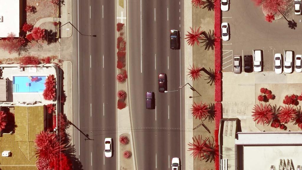
1 A Drone s Eye View on Public Works Applications APWA Construction Inspection Conference Parker, CO Jason Caldwell, VP of Business Development and Sales 2013, The Sanborn Map Company, Inc.

2 Agenda Sanborn Overview and Why UAS? Non Airborne Drones UAS/UAV Technology Sensor Technology Communications Technology Mapping, Remote Sensing Testing Use Cases Current Business Models Regulation Issues Questions 2/24/ , The Sanborn Map Company, Inc. 2

 5 way oblique system (4) Airborne GPS systems")
 Over 1,200")
3 Company Overview Sanborn is an industry leader in terms of acquisition resources and data processing throughput, assets included: Aircraft (12) UltraCam Eagle Digital (3) UltraCamD (2) Integraph Z/I (4) 5 way oblique system (4) Airborne GPS systems (7) Inertial Navigation Systems (6) Trimble GPS survey equipment IT Infrastructure (over a Petabyte of storage) Over 1,200 distributive processing CPUs
4 Comprehensive Solutions Decision Support Systems Wildfire Management Forestry and Ecosystem Management Emergency Response Visualization Systems 2D 3D Prism 4D, Common Operating Picture Software Applications GIS Software Development (Enterprise/Desktop/Web) Portals and Distribution Tools Value Added Services Land use and land cover analyses Change detection Other imagery analysis services Mapping & Remote Sensed Services LiDAR, Digital Orthoimagery, Photogrammetric, Topographical Maps Decision Support Visualization Systems Software Applications Value Added Services (Base Map Analysis) Data and Map Production 4


5 Airborne USGS QL1 LiDAR SAMPLE

6 Mobile Mapping 100 points per Sq. Meter Sample


7 High Resolution Street View Sanborn Mobile Mapping
8 Orthoimagery 3 SAMPLE
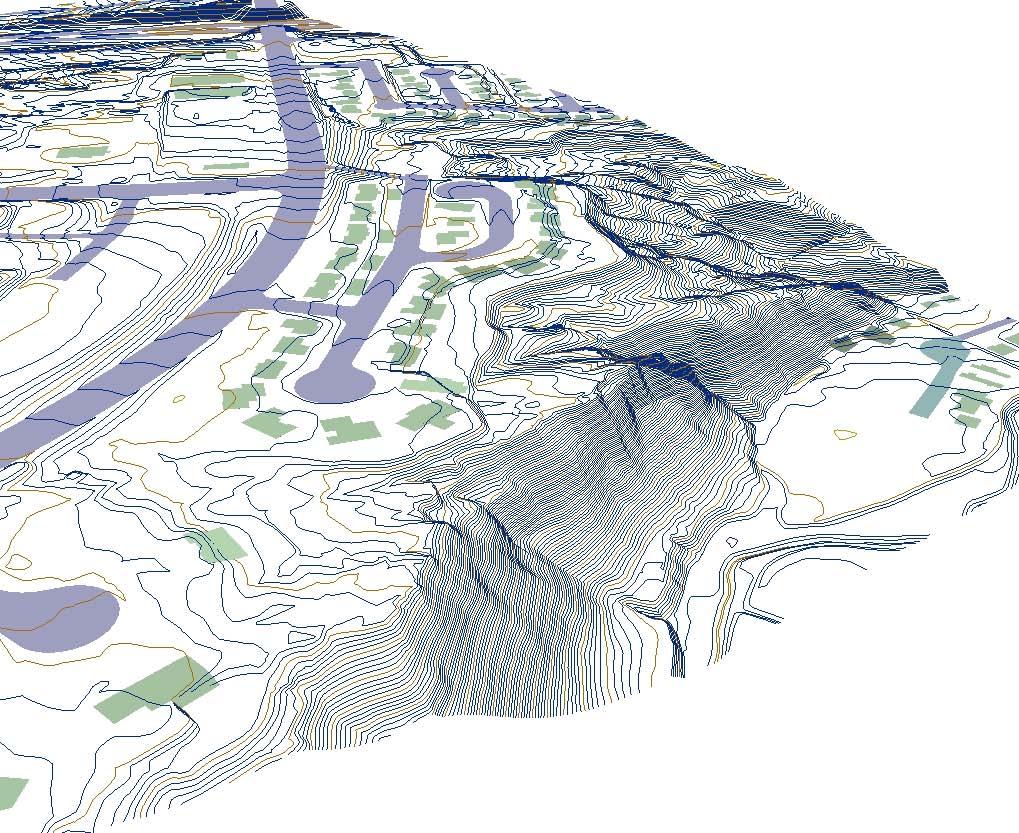


9 Planimetrics


10 Storm Water Utility and Fee Management Using Impervious Data Stormwater Needs Assessment & Rate Structure Development Update & Maintenance Ordinance for New Rate Structure Billing & Collection Public Info Review & Adjustment Cities can revamp their Storm Water Utility Rate Structure using Google Imagery and Sanborn s Premium Impervious Data 10

11 Oblique Imagery 2.5 SAMPLE

12 3D Data


13 2D map of the scanned environment 3D LiDAR intensity point cloud of the scanned area A topological map of the area Derivative products: i. 3D LiDAR intensity point cloud can be vectorized to extract objects in the scene ii. Create photo realistic 3D model of the building interiors iii. Building inventory of the quantity, locations and dimensions of all scanned objects 7/12/

14 2/24/ , The Sanborn Map Company, Inc. 14


15 Unmanned Aerial Vehicles In the US alone, approximately 50 companies, universities, and government organizations are developing and producing over 155 unmanned aircraft designs. 2/24/ , The Sanborn Map Company, Inc. 15


16 UAS System Categories Vertical take off and landing (VTOL) Catapult Start and soft landing 2/24/ , The Sanborn Map Company, Inc. 16


17 Unmanned Aerial Systems UAV UAS Communications Sensors


18 UAS and Sanborn New Verticals Expand offerings into new verticals Develop new offerings for new verticals and expand geographies Integrate technology into existing products and services Allows for expansion into new Markets Allows for expansion into new Services Current Verticals Expand value propositions within existing set of target verticals Develop new offerings for existing target verticals Current Value Propositions New Value Propositions 18


19 2/24/ , The Sanborn Map Company, Inc. 19
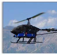
20 Avenger E: Electric UAS Operational Altitude: 5,000 12,000 Ft WGS, no Lift Loss System that is sensor agnostic Full Autopilot : Autonomous flying, terrain following, target tracking, real time GPS waypoints, simultaneous helicopters, etc. Dual Mode Wireless and Laptop Automated return home, max/min altitude setting Payload max of 10 15lbs gvbn5uxes&vq=large Can fly in 50+ MPH cross winds, can land and take off in a small area Manufacture with build, training and maintenance programs Full Turn Key systems: Maintenance, Training and Helicopters, Ground Stations, Wireless communications, etc.
21 Flight Management Integration Auto Take Off, flight and Landing Waypoints 10 CM Accuracy Terrain Following Remote camera settings and GPS integration Real Time Vehicle Data during flight


22 There is a Sensor for the Job 2/24/ , The Sanborn Map Company, Inc. 22

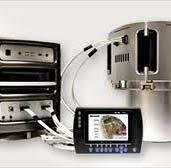
23 Live Down Link Communication Video : Digital/Analog Frequency : L, S and C Power:.25, 1, 2 and 5 Watt Power Range:.5 2 Mile Video : IP Frequency : 5.8 GHz Power: 1, 2 and 5 Watt Power Range: 1 10 Mile Control : Analog Frequency : 900 MHz and 2.4 GHz Power: 1, 2 Watt Power Range: 1 Mile HH, 2 Mile GS Control : IP Frequency : 5.8 GHz Power: 1, 2 and 5 Watt Power Range: 1 10 Mile Control : Satellite Frequency : Iridium Range: 10 Mile 2/24/ , The Sanborn Map Company, Inc. 23


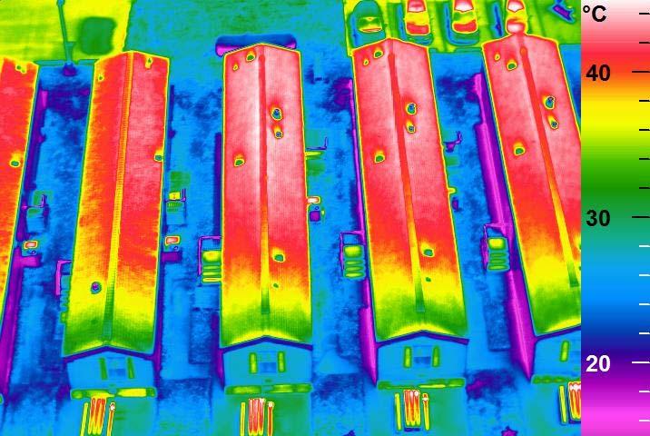
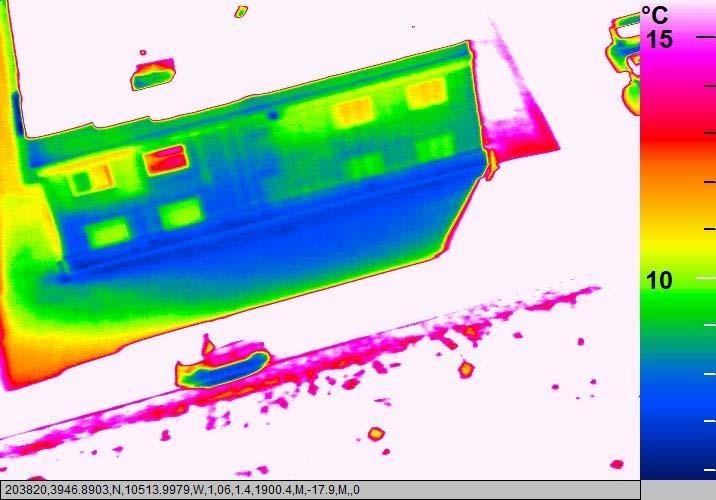
24 Digital Orthoimagery Sub centimeter resolution Horizontal accuracy within 2 pixels Property UHWP


25 Digital Surface Models and 3D Property UHWP 3D Color Photos DSM


26 Elevation Accuracy at 1 2 Centimeter Levels


27 Farms They really could care less about the UAS technology or the imagery except to say it is cool. Surprisingly, most customers were familiar with CIR imagery type. Really what they want is reports that provide information to make faster and better decisions for: Soil typing for new seeding Information about how and when to fertilize Information about plant stress, irrigation or pest based Topography for dirt movement, irrigation etc 2/24/ , The Sanborn Map Company, Inc. 27


28 Testing 1cm GSD vs. Google 2/24/ , The Sanborn Map Company, Inc. 28


29 More Resolution Provides Different Context 2/24/ , The Sanborn Map Company, Inc. 29

30 Web Viewer built on open source and other technology: Crop Health Index DSM Leaflet MapQuest Stamen GDAL Information to be processed automatically within 24 hours of flight. Results: better beer 3cm Multi Spectral Ortho Imagery 2/24/ , The Sanborn Map Company, Inc. 30


31 3cm Resolution Imagery 2/24/ , The Sanborn Map Company, Inc. 31

32 3 5cm vertical accuracy 2/24/ , The Sanborn Map Company, Inc. 32

33 Thermal


34 Video Application Inspection: Active of Hazardous areas and explosives EPA : Avoid Fines and Stack Shutdown that can be up to $1M in cost


35 Ranchers Almost all ranchers have interest in the smaller RDAS UAS system. These applications don t require significant remote sensing processing; essentially all applications are video camera surveillance type of work. Applications included: Livestock locations and issues Grazing patterns Fencing issues Well/Water tanks status Overall surveillance of property I had one rancher tell me he spends four hours every day driving to his water tanks to confirm they have water for his cattle. He wanted to use the RDASS for doing the work instead of driving. 2/24/ , The Sanborn Map Company, Inc. 35


36 Tractor Companies Many of the new tractors that are being offered are drones, they are automated robots. These tractors use GPS guided tools for navigations. Current start up protocol requires driving the tractor around the perimeters of the fields in order to define boundaries which is quite expensive. There is a market to sell a UAS service/devise to complete highly accurate boundary surveys that can be used as input for the tractor navigation. 2/24/ , The Sanborn Map Company, Inc. 36

37 Seed and Fertilizer Companies Insurance review: Guarantees are made to the farmers regarding the products they are purchasing. When issues arise the Farmer calls the seed/fertilizer company to complain about a portion of the crop that is not meeting requirements. Advanced remote sensing: Many of these companies also have interest in completing more advanced techniques for creating better products, understanding soil types and other applications very similar to the Farm applications mention in item 1 above. 2/24/ , The Sanborn Map Company, Inc. 37


38 Fire and Streets Emergency Management/Fire: Stopped by the booth and want share the system throughout the City for different EM requirements. Fire, Police and other for surveillance type of work. Non Ag. City of Greeley Streets Division: Has sensor that measures road surface during ice and snow storms to determine salt and gravel requirements. Sensor is currently used on truck; client thought the UAS platform would be faster and less costly. 2/24/ , The Sanborn Map Company, Inc. 38


39 Police Surveillance/Search Ability to launch in less than 5 minutes Search large areas quickly, HD Video, Night and Infra red Ability to zoom with HD Video or photos of subjects Quiet: At Ft minimal sight and sound recognition Remote live communications feed with cloud broadcast capabilities 2/24/ , The Sanborn Map Company, Inc. 39
 Calibration: Ability to digitally")

40 Police Accident Reconstruction Reduce Trooper exposure to secondary crashes Fast: Take 100 pictures accurately in 5 10 minutes (Instead of ~45 mins) Calibration: Ability to digitally render entire accident scene into CAD drawings for admission into court or case files High Quality: MegaPixel for HD resolution and zoom 2/24/ , The Sanborn Map Company, Inc. 40


41 Prism 4D Common Operating Picture
: The FAA continues")


 Section")
42 FAA Issues: Current Ways to Legally use UAS Unmanned Aerial Systems UAS) integration into the National Airspace System (NAS): The FAA continues efforts to develop the regulatory framework for safely integrating small UAS into routine NAS operations. This will primarily be accomplished by the small UAS (suas) rule, which is scheduled to be released for public comment later this year. Current legal ways to fly suas in the United States include: Model Aircraft Experimental Aircraft Certificate of Authorization (COA) Section 333 Exemption 2/24/ , The Sanborn Map Company, Inc. 42
 2/24/2015 2014, The Sanborn Map Company, Inc.")
43 Business Model: System Sales System sales With and w/o maintenance contract With and w/o sensors packages Hyperspectral RGB Video FLIR LiDAR With and w/o support to obtain Certificate of Authorization (COA) 2/24/ , The Sanborn Map Company, Inc. 43


44 Business Model: Pilot and Processing Services Trained Pilots to provide service to fly client owned Systems Large scale mapping (1 =20 map scale or better) Small AOI updates/maintenance Landfills DOT Survey and Mapping Video monitoring 2/24/ , The Sanborn Map Company, Inc. 44

45 FAA Issues: Current Ways to Legally use UAS Model Aircraft: Recreational use of the UAS is covered by FAA Advisory Circular (AC) 91 57, which generally limits operations to below 400 feet above ground level and away from airports and air traffic. 2/24/

46 FAA Issues: Current Ways to Legally use UAS Experimental UAS: An SAC EC is the only certification means available to civil operators for UAS. Since July 2005, the FAA has issued 94 SAC EC, to 13 civil operators covering 20 unique UAS types. The FAA works with these operators to collect technical and operational data to improve the UAS airworthiness certification process. 2/24/

47 FAA Issues: Current Ways to Legally use UAS Certificate of Authorization (COA) The process is available to public entities, including military, law enforcement, and other governmental agencies who want to fly a UAS in civil airspace. Applicants apply online and the FAA evaluates the request. The COA authorizes an operator to use defined airspace and includes special provisions unique to the proposed operation. Most COAs are issued for a specified time period (up to one year, in most cases). Most COAs require coordination with an appropriate air traffic control facility The FAA issued 146 COAs in 2009 and 298 in 2010, more than doubling in one year. As of June 28, 2011, there were 251 active COAs, 90 different proponents, and 77 different aircraft types. 2/24/


48 FAA Issues: Current Ways to Legally use UAS Section 333 Exemption Section 333, "Special Rules for Certain Unmanned Aircraft Systems," provides flexibility for authorizing safe civil operations in the NAS by granting the Secretary of Transportation the authority to determine whether airworthiness certification is required for a UAS to operate in the NAS. Specifically, Section 333 authorizes the Secretary to determine: This framework will provide operators who wish to pursue safe and legal entry into the NAS a competitive advantage in the UAS marketplace, thus discouraging illegal operations and improving safety. It is anticipated that this activity will result in significant economic benefits, and the FAA Administrator has identified this as a high priority project to address demand for civil operation of UAS for commercial purposes. Astraeus Aerial, Aerial MOB, LLC., Pictorvision Inc., HeliVideo Productions LLC, Snaproll Media LLC, RC Pro Productions Consulting LLC dba Vortex Aerial, Flying Cam, Clayco, Inc., Trimble Navigation, Limited, VDOS Global LLC, Woolpert, Inc., Tierra Antigua Realty, Advanced Aviation Solutions 2/24/ , The Sanborn Map Company, Inc. 48


49 Legislation Congressional Bills Being Introduced for Regulations State Federal Some good, some bad There needs to be a balance between the use of technology and privacy 2/24/
50 Questions Jason Caldwell Vice President of Business Development and Sales /24/ , The Sanborn Map Company, Inc. 50
small Unmanned Aircraft Systems Arlington Police Department June 28, 2011
 suas small Unmanned Aircraft Systems Arlington Police Department June 28, 2011 1. Overview of APD suas program to date 2. Discuss the C.O.A. (FAA certificate of authorization to fly) and restrictions
LAUNCHING YOUR UNMANNED AIRCRAFT PROGRAM
 LAUNCHING YOUR UNMANNED AIRCRAFT PROGRAM THE DARTDRONES TEAM UNMANNED AIRCRAFT APPLICATIONS AERIAL INSPECTIONS AERIAL INSPECTIONS Safer and faster alternative to visual inspection by an individual Damage
Using UAS Technology for Invasive Plant Management
 Using UAS Technology for Invasive Plant Management Adam Benjamin, P.S.M. UF/IFAS Fort Lauderdale R.E.C. May 8, 2018 2018 Aquatic Weed Control Short Course Coral Springs, FL Using UAS Technology for Invasive
OWEA Woolpert UAS Operations
 OWEA 2016 Woolpert UAS Operations UAS Rules and Regulations How Woolpert is Handling This The Exemption In December 2014 Woolpert received approval from the FAA regarding an exemption seeking relief from
Adventures in UAS: Experiences of a UAS Operator. Paul Beckwith, PE, CCM, LEED AP bd+c Navigator CS, LLC, President. Presented by:
 Adventures in UAS: Experiences of a UAS Operator Presented by: Paul Beckwith, PE, CCM, LEED AP bd+c Navigator CS, LLC, President Paul Beckwith, PE, CCM, LEED AP bd+c BA in Architectural Engineering from
Unmanned Aerial Vehicles for Environmental Applications
 Unmanned Aerial Vehicles for Environmental Applications John Rankin, President, J.R. Canadian Mapping Ltd. 10 th Annual Professional Biology Conference April 23 rd, 2015 UAVs Our System Suitable Sites
What is a UAS (Drone)
") UAS KCSI Aerial Patrol KCSI is Based in Bakersfield CA Established in 1993 Operates in 15 States KCSI has over 20 fulltime pilots Currently fly: Over 40,000 miles of pipeline a month 700 hours of production
UAS KCSI Aerial Patrol KCSI is Based in Bakersfield CA Established in 1993 Operates in 15 States KCSI has over 20 fulltime pilots Currently fly: Over 40,000 miles of pipeline a month 700 hours of production
DRONING FOR INFORMATION
 DRONING FOR INFORMATION Opportunity of Drones for Surveying and Mapping Practices By: Adam Smith, CP Matt Aguirre, PLS Overview Introduction Background Problem and Opportunity Issues and Mitigations Implementation
UAS to GIS Utilizing a low-cost Unmanned Aerial System (UAS) for Coastal Erosion Monitoring
 for Coastal Erosion Monitoring") UAS to GIS Utilizing a low-cost Unmanned Aerial System (UAS) for Coastal Erosion Monitoring Agenda Scope of today s presentation Demonstration Objectives Wrightsville Beach Test Area Masonboro Inlet Jetties
UAS to GIS Utilizing a low-cost Unmanned Aerial System (UAS) for Coastal Erosion Monitoring Agenda Scope of today s presentation Demonstration Objectives Wrightsville Beach Test Area Masonboro Inlet Jetties
How to Use Drones in Stormwater Management January 17, :30 a.m. 11:30 a.m. (Eastern)
") Webinar Training Series How to Use Drones in Stormwater Management January 17, 2019 10:30 a.m. 11:30 a.m. (Eastern) www.seswa.org Today s Presenters Robert Gecy Application Programmer Beaufort County,
Webinar Training Series How to Use Drones in Stormwater Management January 17, 2019 10:30 a.m. 11:30 a.m. (Eastern) www.seswa.org Today s Presenters Robert Gecy Application Programmer Beaufort County,
Mapping with Unmanned Airborne Systems (UAS)
") Mapping with Unmanned Airborne Systems (UAS) February 13, 2014 Engineering Architecture Design-Build Surveying GeoSpatial Solutions Today s Agenda Introductions / Objectives Current UAS Regulations (FAA)
Mapping with Unmanned Airborne Systems (UAS) February 13, 2014 Engineering Architecture Design-Build Surveying GeoSpatial Solutions Today s Agenda Introductions / Objectives Current UAS Regulations (FAA)
 Presented by: Lt. Michael J. Magda Team Leader, Firefighter, EMT -P, Hazardous Material Specialist, Private Pilot, Airframe & Power plant Mechanic Western Wayne County HMRT, Livonia Fire & Rescue And
Unmanned Aircraft Systems (UAS) 101
 101") Unmanned Aircraft Systems (UAS) 101 Presented to: AUVSI Cascade Chapter Future Robotics Forum Presented by: Michael Dement-Myers, (FAA), NextGen Branch Date: October 20, 2016 Overview Unmanned Aircraft
Unmanned Aircraft Systems (UAS) 101 Presented to: AUVSI Cascade Chapter Future Robotics Forum Presented by: Michael Dement-Myers, (FAA), NextGen Branch Date: October 20, 2016 Overview Unmanned Aircraft
WEBINAR: A BIRD S-EYE VIEW
 WEBINAR: A BIRD S-EYE VIEW DRONES IN AGRIBUSINESS JUNE 21, 2016 Hosted by Nexsen Pruet Presented by Ernie Pearson (Nexsen Pruet); Patrick Lohman (PrecisionHawk); and Kyle Snyder (NGAT/NCSU) FOUNDED IN
Development and Testing of an Unmanned Aircraft Safety Beacon for Aerial Application Safety
 Development and Testing of an Unmanned Aircraft Safety Beacon for Aerial Application Safety Wayne Woldt, Ph.D., P.E., and Jacob Smith Biological Systems Engineering and School of Natural Resources University
In-field and Remote Sensing for Precision Agriculture. John Nowatzki Extension Ag Machine Systems Specialist North Dakota State University
 In-field and Remote Sensing for Precision Agriculture John Nowatzki Extension Ag Machine Systems Specialist North Dakota State University UAS in Precision Agriculture In-field Sensors Selecting UAS Equipment
Drone Technology: What Works for Industry & Landowners. Michael J. Buschermohle Interim Assistant Dean UT Extension
 Drone Technology: What Works for Industry & Landowners Michael J. Buschermohle Interim Assistant Dean UT Extension So You Want to Fly FAA Regulations UAS Platforms Cameras Applications in Forestry Current
UAV/Drone Uses and Laws
 UAV/Drone Uses and Laws Robert Moorhead Director of Geosystems Research and Northern Gulf Institutes Professor of Electrical & Computer Engineering Unmanned Aerial Systems (UASs) 3 components to the system:
Using UAVs for Aerial Mapping, Surveying and Photography
 Using UAVs for Aerial Mapping, Surveying and Photography Prepared for: Central Florida GIS Workshop 18 September 2013 Kevin Shortelle System Dynamics International, Inc kevinshortelle@bellsouth.net Presentation
Revised June 17, Requirements for the Use of Unmanned Aircraft Systems (UAS) When Filming on State Property
 When Filming on State Property") Revised June 17, 2015 Requirements for the Use of Unmanned Aircraft Systems (UAS) When Filming on State Property In order for a production to be considered for a permit involving a UAS, the following documentation
Revised June 17, 2015 Requirements for the Use of Unmanned Aircraft Systems (UAS) When Filming on State Property In order for a production to be considered for a permit involving a UAS, the following documentation
Unmanned Aerial Systems for Agriculture
 Unmanned Aerial Systems for Agriculture by Bob Schultheis Natural Resource Engineering Specialist for Greene County Soils & Crops Conference Springfield, MO March 18, 2014 Special thanks to Bill Wiebold,
Program. - Flight Operations (VRI) Motivation. The Aircraft / Sensors. Unmanned Aircraft Systems 8/1/17
 Motivation. The Aircraft / Sensors. Unmanned Aircraft Systems 8/1/17") Program Unmanned Aircraft in Agriculture: Flight Operations and FAA Certification Process * 1) Background. Wayne Woldt, Ph.D., P.E. Department of Biological Systems Engineering School of Natural Resources
Program Unmanned Aircraft in Agriculture: Flight Operations and FAA Certification Process * 1) Background. Wayne Woldt, Ph.D., P.E. Department of Biological Systems Engineering School of Natural Resources
Unmanned Aircraft System (UAS): regulatory framework and challenges. NAM/CAR/SAM Civil - Military Cooperation Havana, Cuba, April 2015
: regulatory framework and challenges. NAM/CAR/SAM Civil - Military Cooperation Havana, Cuba, April 2015") Unmanned Aircraft System (UAS): regulatory framework and challenges NAM/CAR/SAM Civil - Military Cooperation Havana, Cuba, 13 17 April 2015 Overview Background Objective UAV? Assumptions Challenges Regulatory
Unmanned Aircraft System (UAS): regulatory framework and challenges NAM/CAR/SAM Civil - Military Cooperation Havana, Cuba, 13 17 April 2015 Overview Background Objective UAV? Assumptions Challenges Regulatory
DEFINITIONS DEFINITIONS 2/11/2017 REQUIREMENTS AND LIMITATIONS OF DRONE USE IN FORENSIC ACCIDENT RECONSTRUCTION
 REQUIREMENTS AND LIMITATIONS OF DRONE USE IN FORENSIC ACCIDENT RECONSTRUCTION ROGER BURGMEIER BURGMEIER CONSULTING INC. DEFINITIONS Aircraft: device that is used, or intended to be used, for flight. Drone:
STOCKTON POLICE DEPARTMENT GENERAL ORDER UNMANNED AIRCRAFT SYSTEM SUBJECT. DATE: November 14, 2017 NO: V-6
 STOCKTON POLICE DEPARTMENT GENERAL ORDER UNMANNED AIRCRAFT SYSTEM SUBJECT DATE: November 14, 2017 NO: FROM: CHIEF ERIC JONES TO: ALL PERSONNEL INDEX: UNMANNED AIRCRAFT SYSTEM I. PURPOSE The purpose of
5 Day Operator Course. 1.0 AIRSPACE CLASSROOM ONLINE EXECUTIVE VO Terms X X Classification
 5 Day Operator Course 2 Day Executive Training 2 Day VO Training 0.1 INTRODUCTION CLASSROOM ONLINE EECUTIVE VO About Avion Solutions Purpose of the course Learning objectives Course outline and schedule
Municipal Drone Operations Ben Roper City of College Station
 Municipal Drone Operations Ben Roper City of College Station Unmanned Aerial System (UAS) aka Drone You are establishing an aviation unit for your entity What could possible go wrong? What is Needed Register
Potential Uses and Considerations Regarding the Use of UAS Technology in Assessment. January 2015 Frank Giuffrida
 Potential Uses and Considerations Regarding the Use of UAS Technology in Assessment January 2015 Frank Giuffrida Table of Contents Current climate surrounding UAS use... 2 Assessing the value of properties
Testimony. of the. National Association of Mutual Insurance Companies. to the. United States House of Representatives
 Testimony of the National Association of Mutual Insurance Companies to the United States House of Representatives Committee on Small Business, Subcommittee on Investigations, Oversight and Regulations
Lone Star UAS Center. of Excellence and Innovation
 Lone Star UAS Center LSUASC Introduction of Excellence and Innovation Bringing UAS to America s Skies NASAO 85 th Annual Convention and Tradeshow UAS Emerging Technologies & Utilizations September 13,
Unmanned Aircraft Operations in the National Airspace System. AGENCY: Federal Aviation Administration (FAA), DOT.
, DOT.") [4910-13] DEPARTMENT OF TRANSPORTATION Federal Aviation Administration 14 CFR Part 91 Docket No. FAA-2006-25714 Unmanned Aircraft Operations in the National Airspace System AGENCY: Federal Aviation Administration
[4910-13] DEPARTMENT OF TRANSPORTATION Federal Aviation Administration 14 CFR Part 91 Docket No. FAA-2006-25714 Unmanned Aircraft Operations in the National Airspace System AGENCY: Federal Aviation Administration
The role of Unmanned Aircraft System (AUS) in search and rescue (SAR) operations
 in search and rescue (SAR) operations") The role of Unmanned Aircraft System (AUS) in search and rescue (SAR) operations Captain: Abdelkhalik Kamaleldin Soliman Selmy College of Maritime Transport & Technology Arab Academy for Science, Technology
The role of Unmanned Aircraft System (AUS) in search and rescue (SAR) operations Captain: Abdelkhalik Kamaleldin Soliman Selmy College of Maritime Transport & Technology Arab Academy for Science, Technology
RISING PERFORMANCE. Civil aviation is an outlier. It s BY ERIK DAHLBERG
 RISING PERFORMANCE Compact mobile mapping systems can be installed on small passenger cars. Civil aviation is an outlier. It s among the few industries where tight government regulations are widely accepted
Unmanned Aircraft Systems (UAS)
") Unmanned Aircraft Systems (UAS) Use & Regulation Presented to: GUIRR Nat l Academy of Sciences Presented by: Robert A. Pappas Special Rules Coordinator UAS Integration Office Date: Who & How UAS are Operating
Unmanned Aircraft Systems (UAS) Use & Regulation Presented to: GUIRR Nat l Academy of Sciences Presented by: Robert A. Pappas Special Rules Coordinator UAS Integration Office Date: Who & How UAS are Operating
UNMANNED AIRCRAFT SYSTEMS (UAS) IN UTILITIES
 IN UTILITIES") UNMANNED AIRCRAFT SYSTEMS (UAS) IN UTILITIES Presented by: Dan Carbone Avion Unmanned Why Drones? Why Drones? Cost Effective Entire cost of a UAS program can be recouped in first-year man-hour savings
UNMANNED AIRCRAFT SYSTEMS (UAS) IN UTILITIES Presented by: Dan Carbone Avion Unmanned Why Drones? Why Drones? Cost Effective Entire cost of a UAS program can be recouped in first-year man-hour savings
Getting off the Ground: Implementing a Drone Program
 Getting off the Ground: Implementing a Drone Program November 2017 Steve Goldman, GISP GIS Manager / UAS Coordinator California Department of Fish and Wildlife http://www.wildlife.ca.gov Drones (UAS) What
4.2 Regional Air Navigation/Safety Developments and Achievements. Group (NAM/CAR ANI/WG) INTEGRATION OF UNMANNED AIRCRAFT SYSTEMS (UAS)
 INTEGRATION OF UNMANNED AIRCRAFT SYSTEMS (UAS)") 03/05/16 Sixth Meeting of the North American, Central American and Caribbean Directors of Civil Aviation (NACC/DCA/06) Nassau, Bahamas, 10 12 May 2016 Agenda Item 4: Accountability Report of the ICAO NACC
03/05/16 Sixth Meeting of the North American, Central American and Caribbean Directors of Civil Aviation (NACC/DCA/06) Nassau, Bahamas, 10 12 May 2016 Agenda Item 4: Accountability Report of the ICAO NACC
Unmanned Aircraft Systems (UAS) 101
 101") Unmanned Aircraft Systems (UAS) 101 Presented to: National Tribal Transportation Conference Presented by: Robert Winn, Aviation Safety Inspector, Unmanned Aircraft Systems Office Date: Overview Unmanned
Unmanned Aircraft Systems (UAS) 101 Presented to: National Tribal Transportation Conference Presented by: Robert Winn, Aviation Safety Inspector, Unmanned Aircraft Systems Office Date: Overview Unmanned
National Regulatory Profile
 National Regulatory Profile Finland NOTE : In this form the following terms are used Drone = Remotely Piloted Aircraft (RPA) = Unmanned Aircraft (UA) = See definition below Drone Pilot = Remote Pilot (RP)
Coeur d Alene Tribe GIS Unmanned Aerial System (UAS) Program JAMES TWOTEETH BERNE JACKSON GIOVAN ALCALA SABINE KRIER
 Program JAMES TWOTEETH BERNE JACKSON GIOVAN ALCALA SABINE KRIER") Coeur d Alene Tribe GIS Unmanned Aerial System (UAS) Program JAMES TWOTEETH BERNE JACKSON GIOVAN ALCALA SABINE KRIER What is an Unmanned Aerial System (UAS)? Small, unmanned aircraft under 50 lbs. remotely
Coeur d Alene Tribe GIS Unmanned Aerial System (UAS) Program JAMES TWOTEETH BERNE JACKSON GIOVAN ALCALA SABINE KRIER What is an Unmanned Aerial System (UAS)? Small, unmanned aircraft under 50 lbs. remotely
UAV Program. What does it take to have a UAV Program Current Requirements Lemhi County UAV program
 UAV Program UAV Program What does it take to have a UAV Program Current Requirements Lemhi County UAV program What does it take to have a UAV program? Some Very Important Questions to Ask Before What type
Commit to Safety: Professional Pilots Always Use a Checklist INITIAL EQUIPMENT SETUP
 Commit to Safety: Professional Pilots Always Use a Checklist INITIAL EQUIPMENT SETUP READ THE MANUAL Familiarize yourself with all aspects of your suas before you even consider going out for your first
Municipal Drone Operations Ben Roper City of College Station
 Municipal Drone Operations Ben Roper City of College Station Unmanned Aerial System (UAS) aka Drone You are establishing an aviation unit for your entity What could possible go wrong? https://youtu.be/aolm1aqkews
Unmanned Aircraft Systems (UAS) 101
 101") Unmanned Aircraft Systems (UAS) 101 Presented to: ACC Airports Technical Workshop Presented by: David Russell, Program Analyst, UAS Integration Office, Date: August 10, 2016 Overview Unmanned Aircraft
Unmanned Aircraft Systems (UAS) 101 Presented to: ACC Airports Technical Workshop Presented by: David Russell, Program Analyst, UAS Integration Office, Date: August 10, 2016 Overview Unmanned Aircraft
AUGUST 2017 GNSS REVIEW. Survey Economics Chances of success. Mobile Mapping Airport scanning. Stag s Leap Winery Pre-construction plan
 AUGUST 2017 GNSS REVIEW Survey Economics Chances of success Stag s Leap Winery Pre-construction plan Mobile Mapping Airport scanning RISING PERFORMANCE» ERIK DAHLBERG Civil aviation is an outlier. It s
UAS Overview IDOT s UAS Program
 Unmanned Aircraft Systems (UAS) UAS Overview IDOT s UAS Program Linda Schumm Bureau Chief Aviation Safety Linda.Schumm@Illinois.gov October 18, 2017 Bill Viste Project Coordinator William.Viste@Illinois.gov
Hazard Identification Questionnaire
 Hazard Identification Questionnaire OVERVIEW This questionnaire is designed to help identify potential risks and help identify areas of risk exposure. It is not an exhaustive list. This questionnaire is
Regional implementation of Electronic Terrain and Obstacle data (e-tod) (Presented by Jeppesen)
 (Presented by Jeppesen)") International Civil Aviation Organization SAM/IG/13-WP/39 South American Regional Office 5/04/14 Thirteenth Workshop/Meeting of the SAM Implementation Group English only (SAM/IG/13) - Regional Project
International Civil Aviation Organization SAM/IG/13-WP/39 South American Regional Office 5/04/14 Thirteenth Workshop/Meeting of the SAM Implementation Group English only (SAM/IG/13) - Regional Project
FAA Unmanned Aircraft Systems (UAS)
") FAA Unmanned Aircraft Systems (UAS) Overview: Proposed Small UAS Rule Presented To: Small Business Aviation Safety Roundtable Presented By: Mark Bury, Assistant Chief Counsel, Regulations Division of the
FAA Unmanned Aircraft Systems (UAS) Overview: Proposed Small UAS Rule Presented To: Small Business Aviation Safety Roundtable Presented By: Mark Bury, Assistant Chief Counsel, Regulations Division of the
AGAZINE DECEMBER 2015/JANUARY 2016
 M IDWEST FLYER AGAZINE DECEMBER 2015/JANUARY 2016 Published For & By The Midwest Aviation Community Since 1978 midwestflyer.com Unmanned Aircraft Systems Technology Creating New Perspectives That Will
Space Based ADS-B. ICAO SAT meeting - June 2016 AIREON LLC PROPRIETARY INFORMATION
 Space Based ADS-B ICAO SAT meeting - June 2016 1 Options to Detect an Aircraft Position Position Accuracy / Update Interval Voice Position Reporting ADS-C Position Reporting Radar Surveillance / MLAT Space
Civil Remotely Piloted Aircraft System (RPAS) Regulations in Australia
 Regulations in Australia") Civil Remotely Piloted Aircraft System (RPAS) Regulations in Australia Cees Bil School of Engineering RMIT University Melbourne AUSTRALIA bil@rmit.edu.au ICAS Workshop: Intelligent and Autonomous Technologies
Civil Remotely Piloted Aircraft System (RPAS) Regulations in Australia Cees Bil School of Engineering RMIT University Melbourne AUSTRALIA bil@rmit.edu.au ICAS Workshop: Intelligent and Autonomous Technologies
LOW DOWN ON THE HIGH UP: USING DRONES FOR LAND CONSERVATION
 LOW DOWN ON THE HIGH UP: USING DRONES FOR LAND CONSERVATION TEXAS LAND CONSERVATION CONFERENCE MARCH 3, 2017 STEPHEN RAMIREZ STEWARDSHIP DIRECTOR TEXAS LAND CONSERVANCY RAY RENNER, RPLS, PMP MANAGER OF
Unmanned Aircraft Systems in Disaster Management and National Preparedness
 Unmanned Aircraft Systems in Disaster Management and National Preparedness at the Hawaii Land Surveyors Association Matt Kobayashi Ted Ralston National Disaster Preparedness Training Center Honolulu Why
INDEX. The association Operations Terrains Current regulations Stakeholders Incidents Future
 RPAS IN BELGIUM INDEX The association Operations Terrains Current regulations Stakeholders Incidents Future THE ASSOCIATION THE ASSOCIATION 4th of July 2012 Six founding members Ten members in total To
Hidalgo County Drone Program. Standard Operating Procedure (SOP) Template. February 23, 2017
 Template. February 23, 2017") Hidalgo County Drone Program Standard Operating Procedure (SOP) Template The following is a detailed (but intended as a comprehensive) framework of topics to be covered in a Standard Operating Procedure
Hidalgo County Drone Program Standard Operating Procedure (SOP) Template The following is a detailed (but intended as a comprehensive) framework of topics to be covered in a Standard Operating Procedure
UAV systems for cultural heritage HERICT ERASMUS IP Technical lecture 2
 UAV systems for cultural heritage HERICT ERASMUS IP Technical lecture 2 Dr. Dimitrios Skarlatos Lecturer Cyprus university of Technology Photogrammetric Vision Lab Dept. of Civil Eng. & Geomatics Dipl.
Unmanned Aircraft Systems (UAS): A Paradigm Shift in Aviation
: A Paradigm Shift in Aviation") Unmanned Aircraft Systems (UAS): A Paradigm Shift in Aviation Tom Haritos, Ed.S. Department of Aeronautical Science Embry-Riddle Aeronautical University Florida Airports Council (FAC) 2015 1 The trouble
Unmanned Aircraft Systems (UAS): A Paradigm Shift in Aviation Tom Haritos, Ed.S. Department of Aeronautical Science Embry-Riddle Aeronautical University Florida Airports Council (FAC) 2015 1 The trouble
Montreal, 15. (Presented SUMMARY
 DGP-WG/2011-IP/4 18/10/12 DANGEROUS GOODS PANEL (DGP) MEETING OF THE WORKING GROUP OF THE WHOLE Montreal, 15 to 19 October 2012 Agenda Item 6: Other business REGULATORY FRAMEWORK FOR REMOTELY PILOTED AIRCRAFT
Systems (UAS) Unmanned Aircraft. Presented to: GWBAA Safety Stand Down Day. Presented by: John Meehan. Date: 17 May AUS-430 Safety & Operations
 Unmanned Aircraft. Presented to: GWBAA Safety Stand Down Day. Presented by: John Meehan. Date: 17 May AUS-430 Safety & Operations") Unmanned Aircraft Systems (UAS) Presented to: GWBAA Safety Stand Down Day Presented by: John Meehan AUS-430 Safety & Operations UAS Integration Office Date: What is a UAS? Unmanned aircraft system (UAS)
Unmanned Aircraft Systems (UAS) Presented to: GWBAA Safety Stand Down Day Presented by: John Meehan AUS-430 Safety & Operations UAS Integration Office Date: What is a UAS? Unmanned aircraft system (UAS)
UAS in Canada Stewart Baillie Chairman Unmanned Systems Canada Sept 2015
 UAS in Canada - 2015 Stewart Baillie Chairman Unmanned Systems Canada Sept 2015 My Focus Today.. Report on the growth of the UAS sector in Canada as a whole Provide background on UAS regulation in Canada
UAS Unmanned Aircra: Systems in Forest Management
 UAS Unmanned Aircra: Systems in Forest Management UAS What are they? Unmanned Aircra: Systems (UAS) fill niche built upon military UAV technologies Most common plahorms Fixed Wing Rotorcra: Primary uses
International Civil Aviation Organization. Satellite spectrum to support the safe operation of Unmanned Aircraft Systems
 International Civil Aviation Organization Satellite spectrum to support the safe operation of Unmanned Aircraft Systems Loftur Jónasson, Air Navigation Bureau, ICAO 23 May 2012 Convention on International
FLIGHT PATH FOR THE FUTURE OF MOBILITY
 FLIGHT PATH FOR THE FUTURE OF MOBILITY Building the flight path for the future of mobility takes more than imagination. Success relies on the proven ability to transform vision into reality for the betterment
GEOMATIC ASSESSMENT Membership Directory & Buyers Guide 97th Annual Conference Recap WINTER 2017/18
 WINTER 2017/18 GEOMATIC NC AWWA-WEA 3725 National Drive, Suite 217 Raleigh, NC 27612 ADDRESS SERVICE REQUESTED 2018 Membership Directory & Buyers Guide 97th Annual Conference Recap The official publication
Definitions. U-SAFE : UAS Secure Autonomous Flight Environment. UTM: UAS Traffic Management
 Definitions U-SAFE : UAS Secure Autonomous Flight Environment UTM: UAS Traffic Management NUSTAR: National UAS Standardized Test and Rating 2 U-SAFE Award Dec 11, 2015 Signature Initiative in Central New
2018 ENGINEERING EXPO Jon Thies NUAIR Director of Consulting
 2018 ENGINEERING EXPO Jon Thies NUAIR Director of Consulting Agenda Operating Under Current FAA Regulations suas Program Development Considerations suas Use Case Examples Quiz Regulations Small Unmanned
Aeros 40D Sky Dragon. TYPE CERTIFIED BY: United States Federal Aviation Administration Civil Aviation Authorities: Europe and Asia
 Aeros 40D Sky Dragon The Aeros 40D Sky Dragon Airship The United States Federal Aviation Administration (FAA) Type Certified Aeros 40D Sky Dragon is the most advanced non rigid airship, incorporating innovative
UNMANNED AIRCRAFT PROVISIONS IN FAA REAUTHORIZATION BILL
 UNMANNED AIRCRAFT PROVISIONS IN FAA REAUTHORIZATION BILL Section 341 Comprehensive Plan -Codifies in title 49 the requirement in the 2012 FAA reauthorization Act that a comprehensive plan to safely accelerate
UAS Integration Activities
 UAS Integration Activities Presented to: Presented by: Ian Ross Senior Representative/Attaché Date: Meeting the Challenge Industry Volume & Pace Personal Nature of UAS Shared Commitment to Safety The Path
Western Service Area Unmanned Aircraft Systems (UAS) Update. Federal Aviation Administration. Defense Symposium
 Update. Federal Aviation Administration. Defense Symposium") Western Service Area Unmanned Aircraft Systems (UAS) Update Presented to: Presented by: Northwest Aerospace & Defense Symposium Matt Gammon, Tactical Operations Team, FAA Western Service Center Date: May
Western Service Area Unmanned Aircraft Systems (UAS) Update Presented to: Presented by: Northwest Aerospace & Defense Symposium Matt Gammon, Tactical Operations Team, FAA Western Service Center Date: May
NextGen Priorities: Multiple Runway Operations & RECAT
 NextGen Priorities: Multiple Runway Operations & RECAT May 2018 Presented by Paul Strande & Jeffrey Tittsworth Federal Aviation Administration National Airspace System Today Air traffic services for the
Airworthiness Criteria: Special Class Airworthiness Criteria for the FlightScan
 This document is scheduled to be published in the Federal Register on 11/16/2017 and available online at https://federalregister.gov/d/2017-24866, and on FDsys.gov [4910-13] DEPARTMENT OF TRANSPORTATION
Future Flight: An FAA Update on UAS
 Unmanned Aircraft Systems (UAS) Future Flight: An FAA Update on UAS Presented to: Georgia Airport Association Annual Conference and Expo Presented by: CAPT Michael K. Wilson UAS Program Manager FAA Southern
DEVELOPING AN ECOSYSTEM FOR UAS SAFETY 2017 WHITEPAPER SERIES
 DEVELOPING AN ECOSYSTEM FOR UAS SAFETY 2017 1 THE ADDITION OF UNMANNED AIRCRAFT SYSTEMS (UAS) TO A CORPORATE FLIGHT DEPARTMENT The use of Unmanned Aircraft Systems (UAS) is becoming popular for varying
Drones, Robots and Public Safety
 Drones, Robots and Public Safety IWCE Thursday, March 30, 2017 11:30 am - 12:45 pm Room: S230 Session Number: TH12 The member organizations of the National Public Safety Telecommunications Council are
The Legal Environment for Commercial Unmanned Aircraft
 The Legal Environment for Commercial Unmanned Aircraft Overview The Legal Environment Who can fly them? A history of FAA policy to the present Asking for permission 2 Today s Legal Framework 3 Today s
Colorado Association of Realtors
 Colorado Association of Realtors Drones in the Real Estate Industry What You Need to Know Tom Dougherty Lewis Roca Rothgerber LLP Overview 1. Introduction to Unmanned Aircraft Systems (UAS) 2. Federal
TABLE OF CONTENTS 1.0 INTRODUCTION...
 Advisory Circular Subject: General Safety Practices Model Aircraft and Unmanned Air Vehicle Systems Issuing Office: Civil Aviation, Standards Document No.: AC 600-02 File Classification No.: Z 5000-31
Unmanned Aircraft System (Drone) Policy
 Policy") Unmanned Aircraft System (Drone) Policy Responsible Officer: Chief Risk Officer Responsible Office: RK - Risk / EH&S Issuance Date: TBD Effective Date: TBD Last Review Date: New Policy Scope: Includes
Unmanned Aircraft System (Drone) Policy Responsible Officer: Chief Risk Officer Responsible Office: RK - Risk / EH&S Issuance Date: TBD Effective Date: TBD Last Review Date: New Policy Scope: Includes
We're not spying on you; it's more interesting watching grass grow-
 We're not spying on you; it's more interesting watching grass grow- Using Unmanned Aircraft Systems in Rangeland Monitoring Connie Maxwell USDA Agricultural Research Service Jornada Experimental Range
Net of Innovation. July 2015 Dave Finger, Mark Foster
 Net of Innovation July 2015 Dave Finger, Mark Foster Table of Contents The Challenges and Solutions to Safe Outdoor Testing... 2 Types of Testing a Netted Enclosure Enables... 4 Flight Plan Testing...
The American Institute of Aeronautics and Astronautics
 The American Institute of Aeronautics and Astronautics Civilian Applications of UAVs A California Perspective, a Policy Symposium Michael Toscano President & CEO Association for Unmanned Vehicle Systems
Community College Risk Management Consortium July 21 22, 2016 Understanding the Evolving Landscape of Drone Regulations and Risk Management
 Community College Risk Management Consortium July 21 22, 2016 Understanding the Evolving Landscape of Drone Regulations and Risk Management The ABCs of UAVs July 2016 UAV Talking Points Drones are changing
PREPARED STATEMENT OF BRIAN WYNNE PRESIDENT AND CEO, ASSOCIATION FOR UNMANNED VEHICLE SYSTEMS INTERNATIONAL
 PREPARED STATEMENT OF BRIAN WYNNE PRESIDENT AND CEO, ASSOCIATION FOR UNMANNED VEHICLE SYSTEMS INTERNATIONAL U.S. Senate Committee on Commerce, Science & Transportation Subcommittee on Aviation Operations,
Launching a New Surveying Perspective
 Launching a New Surveying Perspective >> By Mary Jo Wagner A 3 km2 orthomosaic shows the entire construction site and surroundings. On the upper part of the mosaic are the Bristol Channel; the existing
UAV Flight Services Company. What We Do. What Sets us Apart
 UAV Flight Services Company A dedicated team of aviators, technologists, and engineers. What We Do UAV flight services for data collection, mapping, and inspection What Sets us Apart Extensive field experience,
Airworthiness considerations for UAVs
 A general overview about the approach to a UAV System under current regulations for operation, airspace and certification Presentation by : STN ATLAS ELEKTRONIK Klaus Wohlers, LMP Airborne Systems Type
Airworthiness Certification. The UAS proposed by the petitioner are the.
 2 Airworthiness Certification The UAS proposed by the petitioner are the. The petitioner requested relief from 14 CFR part 21, Certification procedures for products and parts, Subpart H Airworthiness Certificates.
The Freedom of Flight
 The Freedom of Flight Authors: Nicco Bugarin, Keith Kaplan and Wilhelm Cashen Date: May 20 2014 Safe Flight System The Commercialization of UAVS Safe Flight TM System is a Trademark of the Tesla Foundation
Space-Based Aircraft Tracking: Increasing Safety and Reducing Risk in 2018
 Space-Based Aircraft Tracking: Increasing Safety and Reducing Risk in 2018 Alan Khalili, CFO - Aireon Aircraft Builders Conference September 22, 2015 COPYRIGHT 2014 AIREON LLC. ALL RIGHTS COPYRIGHT RESERVED.
Managing small RPAS/UAV operations in developing countries- a Bangladesh Experience. Presented by Bangladesh
 Managing small RPAS/UAV operations in developing countries- a Bangladesh Experience Presented by Bangladesh Managing small RPAS/UAV operations a) Background b) Some Definitions c) Challenges to some article
AGIS/eALP Project Experience
 Agenda AECOM Experience Introduction to AGIS/eALP Executing an AGIS/eALP Sample Data What you can do with the Data? Data Maintenance Questions and Answers AGIS/eALP Project Experience AGIS/eALP Project
Fly for Fun under the Special Rule for Model Aircraft
 US Fly for Fun under the Special Rule for Model Aircraft You don't need permission from the FAA to fly your UAS under the Special Rule for Model Aircraft, but you must always fly safely. You may elect
UNMANNED AIRCRAFT SYSTEMS (UAS) FOR PUBLIC POWER OPERATIONS AN OVERVIEW ON HOW DRONES ARE IMPACTING THE ENERGY INDUSTRY
 FOR PUBLIC POWER OPERATIONS AN OVERVIEW ON HOW DRONES ARE IMPACTING THE ENERGY INDUSTRY") UNMANNED AIRCRAFT SYSTEMS (UAS) FOR PUBLIC POWER OPERATIONS AN OVERVIEW ON HOW DRONES ARE IMPACTING THE ENERGY INDUSTRY ABOUT CHRISTOPHER TODD Founder and president of Airborne Response, Miamibased UAS
UNMANNED AIRCRAFT SYSTEMS (UAS) FOR PUBLIC POWER OPERATIONS AN OVERVIEW ON HOW DRONES ARE IMPACTING THE ENERGY INDUSTRY ABOUT CHRISTOPHER TODD Founder and president of Airborne Response, Miamibased UAS
Re: Exemption Request Section 333 of the FAA Reform Act and Part 11 of the Federal Aviation Regulations
 September 04, 2014 U. S. Department of Transportation Docket Management System 1200 New Jersey Ave., SE Washington, DC 20590 Re: Exemption Request Section 333 of the FAA Reform Act and Part 11 of the Federal
Unmanned Aircraft Systems (UAS) Integration Research
 Integration Research") Unmanned Aircraft Systems (UAS) Integration Research Presented to: Presented by: UAS Midwest Kerin Olson UAS Integration Research Strategy Lead FAA UAS Integration Office Date: FAA UAS Integration Office
Unmanned Aircraft Systems (UAS) Integration Research Presented to: Presented by: UAS Midwest Kerin Olson UAS Integration Research Strategy Lead FAA UAS Integration Office Date: FAA UAS Integration Office
California State University Long Beach Policy on Unmanned Aircraft Systems
 California State University, Long Beach June 14, 2016 Policy Statement: 16-04 California State University Long Beach Policy on Unmanned Aircraft Systems The following policy statement was recommended by
UAS Program. Todd Graetz Director, Technology Services UAS Program / Advanced Train Operations 1
 UAS Program Todd Graetz Director, Technology Services UAS Program / Advanced Train Operations 1 The elements of the program Business requirements Line of Sight (LOS) Implementation Applications Data/product
Requestor Information. Operator/Pilot Information. Owner Information
 Name: Department (if applicable): Email Address: Name of Supervisor (if applicable): Name of Operator/Pilot: Company Name (If applicable): Company Address: Requestor Information Operator/Pilot Information