Design and Construction of the Lake St. Martin Emergency Outlet
|
|
|
- Eugenia Neal
- 5 years ago
- Views:
Transcription

1 Design and Construction of the Lake St. Martin Emergency Outlet
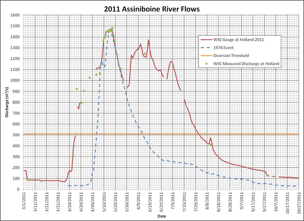
2 Background 2011 was the largest flood event experienced in the last 200 years Flood Fighting required some difficult decisions by the Manitoba Government Assiniboine River runoff was high in peak flow rates and unprecedented in volume and duration All Assiniboine River flows greater than 18,000 cfs had to be diverted into Lake Manitoba to prevent disastrous flooding between Portage la Prairie and Headingley Resulted in unprecedented volumes diverted into Lake Manitoba through the Portage Diversion and highest levels in over 100 years Page 2


3 Flood Protection Works in Manitoba Page 3
4 Page 4
 4.7 ft (1.43m) above the desirable range of 810.")
 5.5 feet (1.")
5 Resulting 2011 Water Levels Lake Manitoba Crested at ft (249.1m) 4.7 ft (1.43m) above the desirable range of ft to ft Lake St. Martin, Crested at ft (245.4m) 5.5 feet (1.68m) above the desirable range of 797 to 800 ft Page 5
6 Project Objective (from MIT mid-june 2011): Identify: Emergency flood relief options from Lake St. Martin and Lake Manitoba Required flow rates to significantly reduce water levels Required earthwork volumes and construction costs Biophysical and socio-economic impacts The recommended options were presented to Manitoba within 5 weeks Page 6
7
8
9

10 Summary of Options Examined Page 10
11 Recommendations KGS & AECOM recommended the following course of action to Manitoba: Begin immediate construction of an additional emergency channel from Lake St. Martin to address the hydraulic flow restrictions in the Dauphin River and accommodate additional Lake Manitoba outflows over the winter; and Allow unrestricted outflow of water from Lake Manitoba through the Fairford River Water Control Structure through the winter of 2011/2012, allowing several times more outflow than past winters. If in service by of the Fall 2011, both lakes could be 2 to 3 feet lower by spring than without emergency channel Page 11

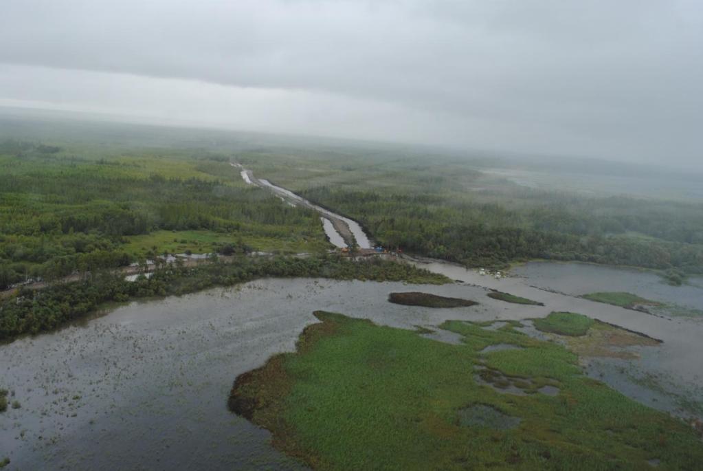
12 Lake St. Martin to Lake Winnipeg Channel Context Page 12
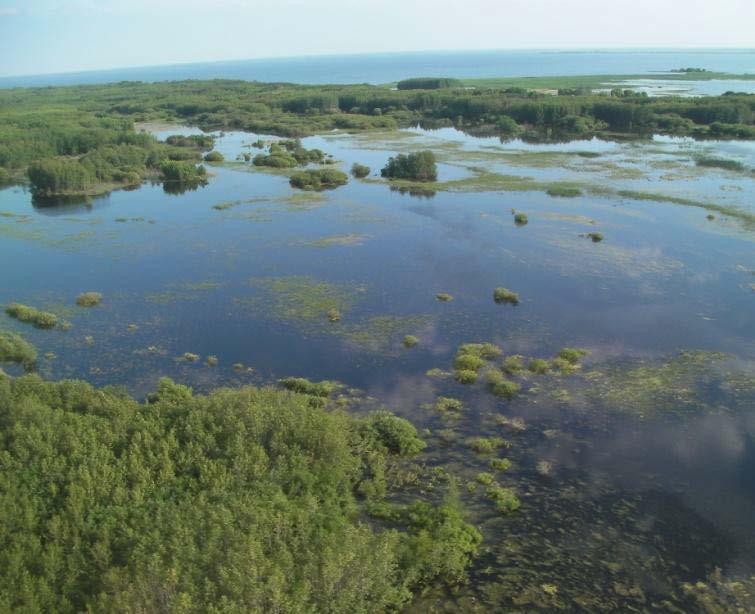
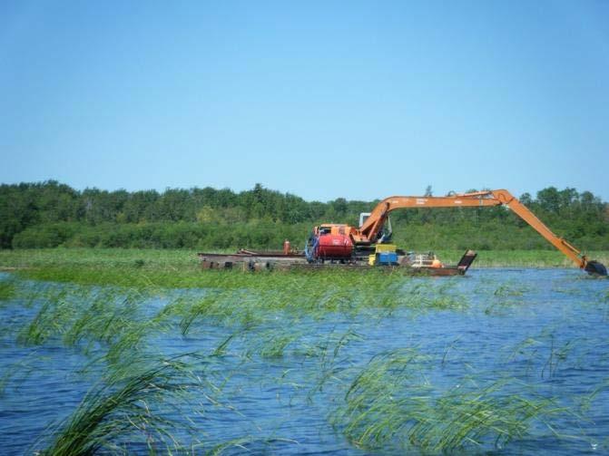
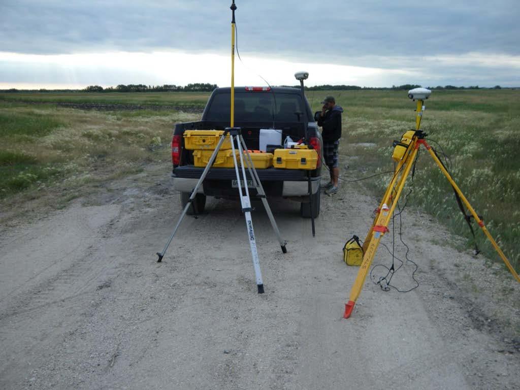
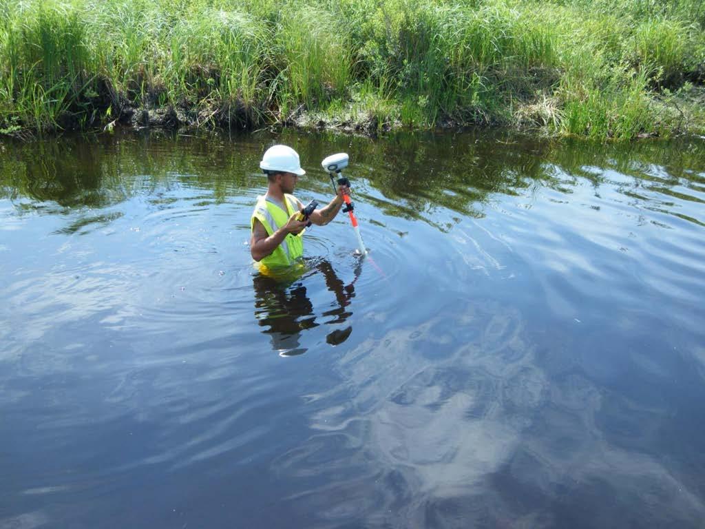
13 Lake St. Martin Emergency Outlet Channel Channel construction from Lake St. Martin approximately 6 km northeast towards Big Buffalo Lake Flow allowed to follow natural flow path to Buffalo Creek which re-enters the Dauphin River approximately 4.5 km upstream of the river mouth June/July 2011: Route investigations, survey, seismic investigations August 2011: Site preparation, layout, securing tugs and barges, developing barge access etc. September 2011: Channel construction, under difficult construction conditions (1.0 to 1.5m wet peat underlain by hard basal till) Page 13


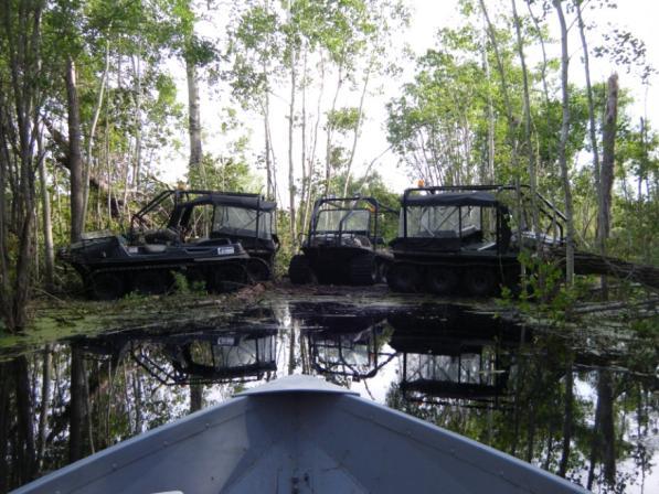
14 Lake St. Martin Emergency Outlet Channel Construction of Outlet Channel: Presented significant timing and constructability challenges Extremely wet and isolated conditions Remote construction access Page 14


15 LSM Outlet Channel Early Access Page 15
16 LSM Outlet Channel Construction Excavating Barge Channel Page 16


17 LSM Outlet Channel Transportation Challenges Page 17
18

19 At its peak the project had: Over 100 pieces of heavy equipment 3 construction camps 3 tugs, 4 barges, 10 support boats 2 helicopters 2 AECOM field offices and A multitude of AECOM personnel for office and field duties Page 19

20 Channel & Spoil Pile Section Illustration Lake St. Martin Channel Construction Page 20

21 Outlet Control Section approx location Page 21


22 Outlet Control Structure 2-D Velocity Model Outlet Control Structure Barge Channel Page 22

23 Lake St. Martin Emergency Outlet Channel Looking North Page 23

24 Lake St. Martin Emergency Outlet Channel Staff and Construction Equipment Over 100 pieces of Equipment Over 150 Construction Staff Over 50 AECOM Staff worked on project 41 from Manitoba Page 24

25 Lake St. Martin Emergency Outlet Channel Approach Channel Construction Page 25

26 Lake St. Martin Emergency Outlet Channel Approach Channel Page 26

27 Lake St. Martin Emergency Outlet Channel Approach Channel Page 27

28 Lake St. Martin Emergency Outlet Channel Big Buffalo Lake Page 28

29 Lake St. Martin Emergency Outlet Channel Big Buffalo Lake Page 29

30 Lake St. Martin Emergency Outlet Channel Big Buffalo Lake Page 30

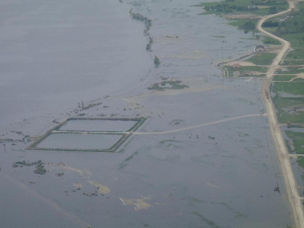
31 Resulting Water Levels Page 31

32 Lake St. Martin Outlet Channel Looking Downstream Page 32

33 Questions?? Page 33
Lake Manitoba Lake St. Martin
 Lake Manitoba Lake St. Martin Outlet Channels Public Information Session June 29, 2017 July 13, 2017 Background & History 2011 Spring Flood Event High flows recorded on most streams and rivers in the Assiniboine
Natural Factors Affecting the Level of Osoyoos Lake
 Natural Factors Affecting the Level of Osoyoos Lake Background Osoyoos Lake is operated under conditions prescribed by the International Joint Commission (IJC) and Figure 1 shows the ranges within which
Observing Subtleties: Traditional Knowledge and Optimal Water Management of Lake St. Martin
 Observing Subtleties: Traditional Knowledge and Optimal Water Management of Lake St. Martin Myrle Traverse and Richard Baydack Abstract Lake St. Martin First Nation is an Anishinaabe community situated
Hydrology Input for West Souris River IWMP
 Hydrology Input for West Souris River IWMP Prepared by: Mark Lee Manitoba Water Stewardship 1 1 1 Overall view of: drainage area watershed characteristics gauging stations meteorological stations Runoff
International Osoyoos Lake Board of Control Annual Report to the International Joint Commission
 International Osoyoos Lake Board of Control 2010 Annual Report to the International Joint Commission TABLE OF CONTENTS ACTIVITIES OF THE BOARD... 1 HYDROLOGIC CONDITIONS IN 2010... 2 Drought Criteria...
Hydraulic Report. Trail 5 Snowmobile Trail Over Mulligan Creek. Prepared By: COLEMAN ENGINEERING COMPANY Karisa V. Falls, P.E.
 Prepared for: Prepared by: Marquette County Road Commission Coleman Engineering Company Marquette, Michigan Iron Mountain, MI December 2011 Hydraulic Report Trail 5 Snowmobile Trail Over Mulligan Creek
Welcome KROSNO CREEK DIVERSION PROJECT CLASS ENVIRONMENTAL ASSESSMENT
 Welcome KROSNO CREEK DIVERSION PROJECT PUBLIC INFORMATION CENTRE # 1 Tonight s Presentation Study Overview Background Existing Conditions Alternative Solutions Preliminary Preferred Solution Next Steps
Triangle Land Conservancy Conservation Area Monitoring Report Carolina North
 Triangle Land Conservancy Conservation Area Monitoring Report Carolina North Property Name: Bolin Creek West Conservation Area Date of visit: March 16, 2017 County: Orange Property Type: Restrictive Covenants
Keeyask Generation Project. Project Description. Supporting Volume. Environmental Impact Statement
 Keeyask Generation Project Environmental Impact Statement Supporting Volume Project Description June 2012 B Size Lan dsca pe BT B - DEC 20 11 Look ing G - 1 O'NEIL BA Y Back Creek G - 3 N - 6 N - 5 N -
Cofferdam Performance Hurricanes Harvey & Irma
 Cofferdam Performance Hurricanes Harvey & Irma - 2017 Greg Hammer Senior Geotechnical Engineer CELRH-DSPC-GS DSMMCX Third Workshop on Case Histories in Dam Safety Risk-Informed Decision Making 2018 USSD
Common Ground Drainage Channel Diversion. Design Report
 Common Ground Drainage Channel Diversion Design Report Resource Management International Inc Consulting Engineers May 2017 COMMON GROUND DRAINAGE CHANNEL DIVERSION PREPARED FOR: QUILL LAKES WATERSHED NO.
4/28/17. Clicker Question. Clicker Question. #37 Floods IV (Case Histories-Mississippi River Flood, 1993; Red River of North Flood, 1997)
") GEOL 118 Final Exam Format similar to exams 1 and 2 Covers Lectures #27 40 (Global Climate Change I - Meteorite Impacts III) Web Exercise #6 - Due by 1 pm, Monday (5/1) 8:00 AM, Thursday, May 11 th Location
GEOL 118 Final Exam Format similar to exams 1 and 2 Covers Lectures #27 40 (Global Climate Change I - Meteorite Impacts III) Web Exercise #6 - Due by 1 pm, Monday (5/1) 8:00 AM, Thursday, May 11 th Location
Application for a Special Flight Operations Certificate
 Application for a Special Flight Operations Certificate for a Large Unmanned High Altitude Balloon by Shaftesbury High School Shaftesbury High Altitude Robotics Project SHARP Date: November 1, 2013 Prepared
Tenders. Manitoba Infrastructure
 Tenders Manitoba Heavy Construction Association Unit 3-1680 Ellice Ave. Winnipeg, MB R3H 0Z2 Tel: (204) 947-1379 Fax: (204) 943-2279 www.mhca.mb.ca Email: jocelyn@mhca.mb.ca Manitoba Infrastructure Reference
Introduction. The System. Model Limitations, Assumptions, and Parameters. Optional Services Tech Memo
 Optional Services Tech Memo Introduction This technical memo evaluates the impact of a tide gate to be installed at the confluence of the Left Bank Tributary of Thalia Creek and Lake Windsor. Specifically,
Bridges and Structures
 Bridges and Structures Commitment: $2. million over five years Manitoba Infrastructure and Transportation has a five-year plan to invest $2 billion in Manitoba s road system. Of this, $.2 billion is for
International Osoyoos Lake Board of Control Annual Report to the International Joint Commission
 International Osoyoos Lake Board of Control 2015 Annual Report to the International Joint Commission Cover: Northern extent of Osoyoos Lake, where the Okanagan River enters the lake, 2015. View is to the
GARFIELD BRIDGE. Building A Bridge to No-Where
 GARFIELD BRIDGE Building A Bridge to No-Where OCEANA COUNTY LOCATION Garfield Road leads to Stony Lake Outlet, a Benona Township park and popular Lake Michigan access GARFIELD BRIDGE OVER STONY CREEK
Final Drainage Letter Pikes Peak Community College Downtown Parking Lot Colorado Springs, Colorado
 Final Drainage Letter Pikes Peak Community College Downtown Parking Lot Colorado Springs, Colorado Prepared for: Pikes Peak Community College 5775 South Academy Boulevard Colorado Springs, CO 80906-5422
London Borough of Barnet Traffic & Development Design Team
 London Borough of Barnet Traffic & Development Design Team AERODROME ROAD PEDESTRIAN FACILITY AND BUS STOP INTRODUCTION FEASIBILITY REPORT Job Number: 60668 Doc Ref: S106/12-13/60668 Author: Manoj Kalair
HILLSBOROUGH COUNTY, FLORIDA AND INCORPORATED AREAS
 VOLUME 2 OF 5 HILLSBOROUGH COUNTY, FLORIDA AND INCORPORATED AREAS Hillsborough County COMMUNITY NAME COMMUNITY NUMBER HILLSBOROUGH COUNTY (UNINCORPORATED AREAS) 120112 PLANT CITY, CITY OF 120113 TAMPA,
Agenda Report. Spruce Street Outlet Drainage Improvements Tower Road Relief Sewer
 Agenda Report Subject: Prepared By: Spruce Street Outlet Drainage Improvements Tower Road Relief Sewer Steven M. Saunders, Director of Public Works/Village Engineer Date: August 12, 2012 On March 8, 2012
Presentation Overview
 DON NARROWS Historical and Existing Conditions March 29, 2008 Presentation Overview 1. Project Location and Background 2. Historical Context How did the Don Narrows Come to Be? 3. The Today 4. Next Steps
Guadalupe Delta Log Jam History & GBRA Operations in the Lower Basin. March 23, 2017
 Guadalupe Delta Log Jam History & GBRA Operations in the Lower Basin March 23, 2017 Guadalupe Watershed Geographic Regions Guadalupe Watershed Geographic Regions Flat Delta Geomorphology Upper Delta Middle
Hydrological study for the operation of Aposelemis reservoir Extended abstract
 Hydrological study for the operation of Aposelemis Extended abstract Scope and contents of the study The scope of the study was the analytic and systematic approach of the Aposelemis operation, based on
April 4, McKinney Airport Advisory Committee Airport Master Plan Update.
 McKinney Airport Advisory Committee Airport Master Plan Update http://mckinney.airportstudy.com/project-documents April 4, 2017 Paul Hendricks phendricks@fairviewtexas.org McKinney National Airport (TKI)
Watchorn Provincial Park. Management Plan
 Watchorn Provincial Park Management Plan 2 Watchorn Provincial Park Table of Contents 1. Introduction... 3 2. Park History... 3 3. Park Attributes... 3 3.1 Natural... 4 3.2 Recreational... 4 3.3 Additional
Portage Spillway Provincial Park. Draft Management Plan
 Portage Spillway Provincial Park Draft Management Plan 2 Portage Spillway Provincial Park Table of Contents 1. Introduction... 3 2. Park History... 3 3. Park Attributes... 4 3.1 Natural... 4 3.2 Recreational...
Equitable Water Apportionment on the Canadian Prairies
 Equitable Water Apportionment on the Canadian Prairies The Master Agreement on Apportionment 1969 & The Prairie Provinces Water Board October, 2017 Alberta - Saskatchewan - Manitoba - Canada 1 Early agreements
International Osoyoos Lake Board of Control Annual Report to the International Joint Commission
 International Osoyoos Lake Board of Control 2013 Annual Report to the International Joint Commission TABLE OF CONTENTS ACTIVITIES OF THE BOARD... 1 HYDROLOGIC CONDITIONS IN 2013... 2 Drought Criteria...
Arlington County Board Meeting Project Briefing. October 20, 2015
 Arlington County Board Meeting Project Briefing October 20, 2015 Project Map 2 Project Context Only Interstate in the Country limited to HOV only traffic during rush hours Stoplight at the end of I-66
Miner & Silverstein Appraisal Company Division of Miner & Silverstein, LLP
 Miner & Silverstein Appraisal Company Division of Miner & Silverstein, LLP Marina Market Analysis Upper Connecticut River Marina Market Study Winter 2005-2006 The following presents a winter 2005-06 market
Principle Causes of Dam Failures. Structural failure. Cracking. Stability failure. BIA Summer Water Resources Training Dam Safety Inspections
 BIA Summer Water Resources Training Dam Safety Inspections Principle Causes of Dam Failures Part 2 Dam Failures July 28, 2012 Presented by Michael Johnson, Ph.D., P.E. Overtopping Structural failure Stability
Triangle Land Conservancy Conservation Area Monitoring Report Carolina North
 Triangle Land Conservancy Conservation Area Monitoring Report Carolina North Property Name: Bolin Creek East Conservation Area Date of visit: March 16, 2017 County: Orange Property Type: Restrictive Covenants
Chapter 10. Damage to Ports and Coastal Facilities
 Chapter 10 Damage to Ports and Coastal Facilities 10.1 Area Investigated Tsunami induced heavy damage to ports and coastal facilities along the west and north coast of Sumatra Island. Figure 10.1 shows
January 14,2010. Ms. Linda Bassi Colorado Water Conservation Board 1313 Sherman Street, Room 723 Denver, CO Dear Linda,
 STATE OF COLORADO Bill Ritter, Jr., Governor DEPARTMENT OF NATURAL RESOURCES DIVISION OF WILDLIFE AN EQUAL OPPORTUNITY EMPLOYER Thomas E. Remington, Director 6060 Broadway Denver, Colorado 80216 Telephone:
HYDROLOGY OF GLACIAL LAKES, FORT SISSETON AREA
 PROC. S.D. ACAD. SCI., VOL. 77 (1998) 59 HYDROLOGY OF GLACIAL LAKES, FORT SISSETON AREA Perry H. Rahn Department of Geology & Geological Engineering South Dakota School of Mines and Technology Rapid City,
Alberta Urban Municipalities Association November 23. Tom Sampson Chief, Calgary Emergency Management Agency Commander, Canada Task Force 2
 Alberta Urban Municipalities Association 2017 November 23 Tom Sampson Chief, Calgary Emergency Management Agency Commander, Canada Task Force 2 ISC: Unrestricted 1 Canada Task Force 2 2 3 What is our role
Port McNeill - Alert Bay Alternate Service Tug & Barge Service Proposed Port McNeill Ramp
 Port McNeill - Alert Bay Alternate Tug & Barge Proposed Port McNeill Ramp Ba Dates: April 8th to April 26th Fer c ei ry S Sointula e rry Fe Tu g& Ba rg es er vic e & Tug rge Proposed Alert Bay Ramp Tug
POST-IMPLEMENTATION COMMUNITY IMPACT REVIEW
 POST-IMPLEMENTATION COMMUNITY IMPACT REVIEW RNAV STAR updates and RNP AR approaches at Winnipeg James Armstrong Richardson International Airport NAV CANADA 77 Metcalfe Street Ottawa, Ontario K1P 5L6 November
4180 acre-feet minimum conservation pool
 MEMORANDUM Subject: Bear River Basin Plan SULPHUR CREEK RESERVOIR Date: July 20, 2000 Location: Section 34, Township 14N, Range 119W. Located on Sulphur Creek, tributary to the Bear River. Located approximately
Neso Lake. Classification: Landscape Description: Park Purpose: Recreation Park
 Neso Lake Classification: Recreation Park Landscape Description: This small recreation park provides access to Neso Lake and the Mistik Creek canoe route. It is located in the Churchill River Upland portion
GOOSENECK SWAMP INFORMATION DAY - Saturday 14 th December 2013
 GOOSENECK SWAMP INFORMATION DAY - Saturday 14 th December 2013 Progress of a restoration trial at Gooseneck Swamp - Grampians National Park, Victoria Gooseneck Swamp is situated at the far south-eastern
USGS Methods of Collecting High Water Marks (HWMs)
") USGS Methods of Collecting High Water Marks (HWMs) A. Thomas Ruby III Supervisory Hydrologist Indiana-Kentucky Water Science Center U.S. Department of the Interior U.S. Geological Survey Outline: Overview
USGS Methods of Collecting High Water Marks (HWMs) A. Thomas Ruby III Supervisory Hydrologist Indiana-Kentucky Water Science Center U.S. Department of the Interior U.S. Geological Survey Outline: Overview
II. THE BOULDER CREEK DRAINAGE BASIN
 II. THE BOULDER CREEK DRAINAGE BASIN This section provides an overview of the watersheds and flood hazards associated with Boulder Creek and South Boulder Creek including descriptions of the drainage basins,
LITTLE LOST MAN CREEK (LLM) (formerly USGS Gaging Station No )
 (formerly USGS Gaging Station No )") LITTLE LOST MAN CREEK (LLM) (formerly USGS Gaging Station No. 11482468) LOCATION: In Redwood National and State Park approximately 0.8 miles upstream from confluence with Prairie Creek and 3.2 miles northeast
LITTLE LOST MAN CREEK (LLM) (formerly USGS Gaging Station No. 11482468) LOCATION: In Redwood National and State Park approximately 0.8 miles upstream from confluence with Prairie Creek and 3.2 miles northeast
2018 SPRING ROAD RESTRICTIONS (SRR) ORDER # 1 RESPECTING THE OPERATION OF VEHICLES ON HIGHWAYS IN THE PROVINCE OF MANITOBA
 ORDER # 1 RESPECTING THE OPERATION OF VEHICLES ON HIGHWAYS IN THE PROVINCE OF MANITOBA") 2018 SPRING ROAD RESTRICTIONS (SRR) ORDER # 1 RESPECTING THE OPERATION OF VEHICLES ON HIGHWAYS IN THE PROVINCE OF MANITOBA Pursuant to subsections 86(1), 86(2) and 86(3), The Highway Traffic Act (C.C.S.M.
2018 SPRING ROAD RESTRICTIONS (SRR) ORDER # 1 RESPECTING THE OPERATION OF VEHICLES ON HIGHWAYS IN THE PROVINCE OF MANITOBA Pursuant to subsections 86(1), 86(2) and 86(3), The Highway Traffic Act (C.C.S.M.
Keeyask Generation Project. Project Description. Supporting Volume. Environmental Impact Statement
 Keeyask Generation Project Environmental Impact Statement Supporting Volume Project Description June 2012 Vertical Shaft Turbine Powerhouse Cross Section Bulb Turbine Powerhouse Cross Section Crane Trashracks
ENLOE HYDROELECTRIC PROJECT FERC PROJECT NO PUBLIC SAFETY PLAN. Final
 ENLOE HYDROELECTRIC PROJECT FERC PROJECT NO. 12569 PUBLIC SAFETY PLAN Final November 18, 2013 Okanogan Public Utility District 1331 2nd Ave N PO Box 912 Okanogan, WA 98840 ENLOE HYDROELECTRIC PROJECT FERC
HISTORICAL FLOOD LEVELS
 5.36 5.02 3.58 3.59 3.68 3.67 3.21 2.87 3.01 2.91 2.8 3.78 2.42 4.02 2.4 2.37 2.35 2.06 2.41 2.39 2.39 2.37 2.39 2.4 2.39 2.14 2.06 2.39 2.41 2.42 2.31 2.14 2.3 1.5 2.38 2.16 2.43 1.5 2.43 1.91 4.93 4.63
4. Hydrology of the Olentangy River Watershed
 4. Hydrology of the Olentangy River Watershed The Hydrologic Cycle Water on Planet Earth is dynamic constantly being recycled from the land to the atmosphere to the ocean. Rivers and streams are just a
Air Traffic Flow Management (ATFM) in the SAM Region METHODOLOGY ADOPTED BY BRAZIL TO CALCULATE THE CONTROL CAPACITY OF ACC OF BRAZILIAN FIR
 in the SAM Region METHODOLOGY ADOPTED BY BRAZIL TO CALCULATE THE CONTROL CAPACITY OF ACC OF BRAZILIAN FIR") International Civil Aviation Organization SAM/IG/6-IP/03 South American Regional Office 21/09/10 Sixth Workshop/Meeting of the SAM Implementation Group (SAM/IG/6) - Regional Project RLA/06/901 Lima, Peru,
International Civil Aviation Organization SAM/IG/6-IP/03 South American Regional Office 21/09/10 Sixth Workshop/Meeting of the SAM Implementation Group (SAM/IG/6) - Regional Project RLA/06/901 Lima, Peru,
Annual Report to the. International Joint Commission. from the. International Osoyoos Lake Board of Control for
 Annual Report to the International Joint Commission from the International Osoyoos Lake Board of Control for Calendar Year 2005 INTERNATIONAL JOINT COMMISSION International Osoyoos Lake Board of Control
Note that the steepest 8 direction pour point model slope in direction 64 is: 10.0
 GIS in Water Resources Exercise #3 Solution Part 1. 1.1 Hand Calculations (i) The standard ESRI surface slope function Grid size 10 m Diagonal distance= 14.142 m 47.5 48 47.7 50.6 48.3 dz/dx= -0.125 45.1
Study 7 (Part 1): Demonstration of Factors that Govern Osoyoos Lake Levels During High Water Periods
: Demonstration of Factors that Govern Osoyoos Lake Levels During High Water Periods") Study 7 (Part 1): Demonstration of Factors that Govern Osoyoos Lake Levels During High Water Periods International Joint Commission March 2010 EXECUTIVE SUMMARY Introduction The operation of Zozel Dam
Study 7 (Part 1): Demonstration of Factors that Govern Osoyoos Lake Levels During High Water Periods International Joint Commission March 2010 EXECUTIVE SUMMARY Introduction The operation of Zozel Dam
Beaver Creek Provincial Park. Management Plan
 Beaver Creek Provincial Park Management Plan 2 Beaver Creek Provincial Park Table of Contents 1. Introduction... 3 2. Park History... 3 3. Park Attributes... 4 3.1 Natural... 4 3.2 Recreational... 4 4.
Felixstowe Branch Line FAQ
 Felixstowe Branch Line FAQ How was the location of the track doubling work decided? We undertook a study to identify how to meet the freight demand along the Felixstowe Branch Line by modelling the route.
Numaykoos Lake Provincial Park. Management Plan
 Numaykoos Lake Provincial Park Management Plan 2 Numaykoos Lake Provincial Park Table of Contents 1. Introduction... 3 2. Background... 3 3. Park Purpose... 5 4. Park Management Guidelines... 6 Appendix...
Appendix B. Comparative Risk Assessment Form
 Appendix B Comparative Risk Assessment Form B-1 SEC TRACKING No: This is the number assigned CRA Title: Title as assigned by the FAA SEC to the CRA by the FAA System Engineering Council (SEC) SYSTEM: This
12, 14 and 16 York Street - Amendments to Section 16 Agreement and Road Closure Authorization
 REPORT FOR ACTION 12, 14 and 16 York Street - Amendments to Section 16 Agreement and Road Closure Authorization Date: April 27, 2018 To: Toronto and East York Community Council From: Senior Strategic Director,
San Antonio's River Walk Behind the scenes tour or did you know?
 San Antonio's River Walk Behind the scenes tour or did you know? Robert B. Kauffman, Ph.D 7 Hill Top Drive Frostburg, MD 21532 o: (301) 687-4474 e: rkauffman@frostburg.edu All historical slides are from
EON-NTM CR4 Export Cable Installation Update Update. Notice to Mariners
 Dear Owners, Ships Agents, Masters, Pilots and Fishermen, Re: -.EON-NTM-00118-Installation of New Export Cable Update The layout drawing has been updated to reflect an additional 16 x 2.5-ton Delta Flipper
Triangle Land Conservancy Conservation Area Monitoring Report Carolina North
 Triangle Land Conservancy Conservation Area Monitoring Report Carolina North Property Name: Bolin Creek East Conservation Area Date of visit: 4/8/2015 County: Orange Property Type: Restrictive Covenants
DIDYMO SURVEY, LOWER FRYINGPAN RIVER, BASALT, COLORADO 2015
 DIDYMO SURVEY, LOWER FRYINGPAN RIVER, BASALT, COLORADO 2015 Second Annual Report PREPARED FOR: ROARING FORK CONSERVANCY PREPARED BY: COLORADO MOUNTAIN COLLEGE NATURAL RESOURCE MANAGEMENT PROGRAM TIMBERLINE
Noise Abatement Arrival Procedures at Louisville International Airport. Prof. John-Paul Clarke Georgia Institute of Technology
 Noise Abatement Arrival Procedures at Louisville International Airport Prof. John-Paul Clarke Georgia Institute of Technology The Team Noise Abatement Procedures Working Group (NAPWG) has the following
Chapter 2: Entire US287 Corridor
 Chapter 2: Entire US287 Corridor The US287 Study Area spans four incorporated jurisdictions and two counties. Due to the length and density of infrastructure along the US287 Study Area, corridor-wide maps
Open Report on behalf of Richard Wills, Executive Director for Environment & Economy. Nettleham Village Centre - Proposed Parking Restrictions
 Agenda Item 4.3 Regulatory and Other Committee Open Report on behalf of Richard Wills, Executive Director for Environment & Economy Report to: Planning & Regulation Committee Date: 16 February 2015 Subject:
Event Travel Plan. Poppies: Wave. Southend-on-Sea Borough Council
 Event Travel Plan Poppies: Wave Southend-on-Sea Borough Council 1.0 Introduction 1.1 Background Southend-on-Sea has been selected as one of two locations in 2017 to host the Poppies: Wave sculpture as
GIFFORD PINCHOT NATIONAL FOREST
 GIFFORD PINCHOT NATIONAL FOREST 9341 Wright Meadow 93 Spencer Meadow Spencer Butte 4247' 30 30A 19 24 80 31C Lewis River Lower Falls 5 Quartz Creek 90 Taidnapam Falls Upper Falls 31 Spencer Peak 3861'
Lawrence Loop SWOT Analysis
 Alignment: D1 (Map Color: Dark Blue) Description: This alignment connects to the north end of the Burroughs Creek Trail and continues along the west side of the Railroad to 8 th Street. Strengths: - This
Original Report F WIN , F WIN Prepared for Northland Power and Ministry of Tourism and Culture
 STAGE 2 ARCHAEOLOGICAL ASSESSMENT McLEAN S MOUNTAIN WIND FARM Part Lots 12-15, Concession 3 Geographic Township of Howland Part Lot 24, Concession 12 Geographic Township of Bidwell and Goat Island (formerly
Guide to the L. F. Manis Photographs
 This finding aid was produced using ArchivesSpace on February 29, 2016. English 2016 The Regents of the University of Nevada. All rights reserved. University of Nevada, Las Vegas. University Libraries.
PROGRAM. presented by
 S C H O O L PROGRAM 2018 presented by INTRODUCTION We invite you to learn about Fort Gibraltar s influence over the cultural development of the Red River settlement. Delve into the lore of the French Canadian
Colombia (South America) Water use and drainage in Colombia. Case Study: The Stormwater Challenge in Barranquilla. Humberto Avila.
 Water use and drainage in Colombia. Case Study: The Stormwater Challenge in Barranquilla. Humberto Avila.") Colombia (South America) Water use and drainage in Colombia Location: Case Study: The Stormwater Challenge in Barranquilla Source: Wikipedia The University of Alabama February 25, 2008 Population: 45 million
Colombia (South America) Water use and drainage in Colombia Location: Case Study: The Stormwater Challenge in Barranquilla Source: Wikipedia The University of Alabama February 25, 2008 Population: 45 million
Guide to the L. F. Manis Photographs
 This finding aid was created by Lindsay Oden on February 27, 2018. Persistent URL for this finding aid: http://n2t.net/ark:/62930/f1vk60 2018 The Regents of the University of Nevada. All rights reserved.
AN OUTLINE OF THE NILE BASIN
 The Hydrology of the Nile by J. V. Sutcliffe & Y. P. Parks. IAHS Special Publication no. 5, 1999. CHAPTER 1 AN OUTLINE OF THE NILE BASIN INTRODUCTION The hydrology of the Nile basin cannot be understood
Lidar Imagery Reveals Maine's Land Surface in Unprecedented Detail
 Maine Geologic Facts and Localities December, 2011 Lidar Imagery Reveals Maine's Land Surface in Unprecedented Detail Text by Woodrow Thompson, Department of Agriculture, Conservation & Forestry 1 Introduction
LESOTHO HIGHLANDS DEVELOPMENT AUTHORITY
 LESOTHO HIGHLANDS DEVELOPMENT AUTHORITY ANNUAL FLOW RELEASES INSTREAM FLOW REQUIREMENT (IFR) IMPLEMENTATION AND MONITORING (October 2005 to September 2006) REPORT N0.7 OCTOBER 2007 STRATEGIC AND CORPORATE
Investigation of River Stage Simulation Before and After Bengoh Dam Construction: Case Study of Sarawak River Basin Malaysia
 International Journal of Science and Engineering Investigations vol. 4, issue 42, July 2015 ISSN: 2251-8843 Investigation of River Stage Simulation Before and After Bengoh Dam Construction: Case Study
Plans and Design Calculations for the Alder Creek Diversion Fish Screen
 TECHNICAL MEMORANDUM Plans and Design Calculations for the Alder Creek Diversion Fish Screen El Dorado Irrigation District 2890 Mosquito Road Placerville, CA 95667 Alder Creek Diversion Fish Screen Plans
MP : Blue Hill and the Disney Avalanche Path
 MP 252-253: Blue Hill and the Disney Avalanche Path This section of the Auto Tour includes a portion of the wagon road, one of Colorado s most famous avalanches and the remains of an old dam. Route Mile
NORTH CASCADE SLACIER CLIMATE PROJECT Director: Dr. Mauri S. Pelto Department of Environmental Science Nichols College, Dudley MA 01571
 NORTH CASCADE SLACIER CLIMATE PROJECT Director: Dr. Mauri S. Pelto Department of Environmental Science Nichols College, Dudley MA 01571 INTRODUCTION The North Cascade Glacier-Climate Project was founded
How much did the airline industry recover since September 11, 2001?
 Catalogue no. 51F0009XIE Research Paper How much did the airline industry recover since September 11, 2001? by Robert Masse Transportation Division Main Building, Room 1506, Ottawa, K1A 0T6 Telephone:
PLUME RISE ASSESSMENTS
 Advisory Circular AC 139-5(1) NOVEMBER 2012 PLUME RISE ASSESSMENTS CONTENTS Page 1. References 1 2. Purpose 2 3. Status of this advisory circular 2 4. Acronyms 2 5. Definitions 3 6. Background 3 7. Key
Triangle Land Conservancy Conservation Area Monitoring Report Carolina North
 Triangle Land Conservancy Conservation Area Monitoring Report Carolina North Property Name: Crow Branch Conservation Area Date of visit: March 16, 2016 County: Orange Property Type: Restrictive Covenants
Sasagiu Rapids Provincial Park. Draft Management Plan
 Sasagiu Rapids Provincial Park Draft Management Plan 2 Sasagiu Rapids Provincial Park Table of Contents 1. Introduction... 3 2. Background and Park Attributes... 3 2.1 Park History.... 3 2.2 Natural Features...
Request for Proposal National Tropical Botanical Garden Lower Limahuli Preserve Emergency Stream Debris Removal
 Request for Proposal National Tropical Botanical Garden Lower Limahuli Preserve Emergency Stream Debris Removal I. Summary of Work Bids are solicited for the emergency removal of debris deposited in the
CONSERVATION VOLUNTEERS INTERNATIONAL PROGRAM VOLUNTEER TRIP TO TORRES DEL PAINE NATIONAL PARK, PATAGONIA, CHILE DECEMBER 2010
 CONSERVATION VOLUNTEERS INTERNATIONAL PROGRAM VOLUNTEER TRIP TO TORRES DEL PAINE NATIONAL PARK, PATAGONIA, CHILE DECEMBER 2010 We, Richard and Chris Braunlich, co-leaders of the volunteer trip, met the
TABLE OF CONTENTS. General Study Objectives Public Involvement Issues to Be Resolved
 TABLE OF CONTENTS Description Page Number LIST OF ACRONYMS... a CHAPTER ONE INTRODUCTION General... 1-1 Study Objectives... 1-1 Public Involvement... 1-2 Issues to Be Resolved... 1-2 CHAPTER TWO EXISTING
EAST SIDE TRANSPORTATION INITIATIVE APEGM SEPTEMBER 9, 2009
 EAST SIDE TRANSPORTATION INITIATIVE APEGM SEPTEMBER 9, 2009 EAST SIDE TRANSPORTATION INITIATIVE AREA First Nations Northern Affairs Communities Metis Peoples PROCESSES EAST SIDE ROAD AUTHORITY (ESRA) CROWN
Wilts & Berks Canal. Appendix E: Hydrology and Hydraulics CONTENTS 1. INTRODUCTION 2 2. HYDROLOGY 2 3. HYDRAULIC MODEL 2 4.
 Wilts & Berks Canal Melksham River Route Study Appendix E: Hydrology and Hydraulics CONTENTS 1. INTRODUCTION 2 2. HYDROLOGY 2 3. HYDRAULIC MODEL 2 4. CANAL OPERATION 3 5. WEIR DESIGN 4 6. FLOOD RISK 5
China Creek North Park Upgrades and Glen Pump Station. Park Board Committee Meeting Monday, July 10, 2017
 China Creek North Park Upgrades and Glen Pump Station Park Board Committee Meeting Monday, July 10, 2017 Purpose The purpose of this presentation is to: Share the results of the public engagement processes;
Triangle Land Conservancy Conservation Area Monitoring Report Carolina North
 Triangle Land Conservancy Conservation Area Monitoring Report Carolina North Property Name: Crow Branch Conservation Area Date of visit: 4/8/2015 County: Orange Property Type: Restrictive Covenants Local
Tenders. Manitoba Heavy Construction Association Unit Ellice Ave. Winnipeg, MB R3H 0Z2 Tel: (204) Fax: (204)
 Fax: (204)") Tenders Manitoba Infrastructure Manitoba Heavy Construction Association Unit 3-1680 Ellice Ave. Winnipeg, MB R3H 0Z2 Tel: (204) 947-1379 Fax: (204) 943-2279 www.mhca.mb.ca Reference No. 0000087389 SUPPLY
Tenders Manitoba Infrastructure Manitoba Heavy Construction Association Unit 3-1680 Ellice Ave. Winnipeg, MB R3H 0Z2 Tel: (204) 947-1379 Fax: (204) 943-2279 www.mhca.mb.ca Reference No. 0000087389 SUPPLY
LESOTHO HIGHLANDS DEVELOPMENT AUTHORITY
 LESOTHO HIGHLANDS DEVELOPMENT AUTHORITY ANNUAL FLOW RELEASES INSTREAM FLOW REQUIREMENT (IFR) IMPLEMENTATION AND MONITORING (October 2004 to September 2005) TOWER ON MALIBAMATŠO RIVER @ KAO REPORT N0.6
Progress Report Copyright 2005, Sevenson Environmental Services, Inc. All Rights Reserved.
 Stone Harbor Maintenance Dredging Stone Harbor, NJ Weather Low Reports No. Project No. Report Date: Day of Week: High 42 33 63 45 2/8/6 Thursday Daily Precipitation. Weather Conditions: Overcast 2 Progress
Spencer Environmental Appendix A: Alternative Analysis for Construction Access Route
 Spencer Environmental Appendix A: Alternative Analysis for Construction Access Route February 2015 Valley ine-stage 1 RT EISA Update FINA REPORT Page A1 Memorandum AECOM ConnectEd Transit Partnership 10235
A Little Piece of Missouri River History
 John William Adcock John William Adcock was born April 8, 1867, on a farm south of Eldon, Miller County, Missouri. He began his steamboating career on the Osage and Missouri Rivers as a deckhand on the
Wilts and Berks Canal Trust
 Wilts and Berks Canal Trust Melksham Link Waterway, Pedestrian and Off-road Cycle Routes Engineering Design Contents Background 4 Technical Design Part 1 Semington to Berryfield 5 Part 2 Berryfield to
REVIEW OF PERTH AIRPORT Noise Abatement Procedures
 REVIEW OF PERTH AIRPORT Noise Abatement Procedures Contents SUMMARY... 3 Summary of Review Findings... 3 BACKGROUND... 4 Noise Abatement Procedures... 4 Perth Airport Noise Abatement Procedures... 4 Noise