HISTORICAL FLOOD LEVELS
|
|
|
- Juliet Black
- 6 years ago
- Views:
Transcription
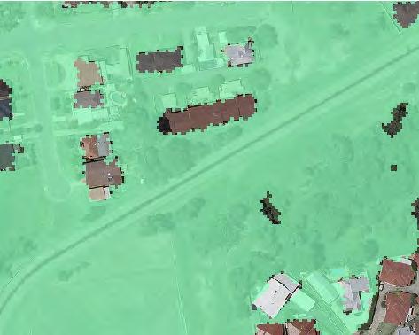
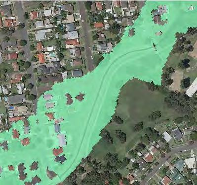
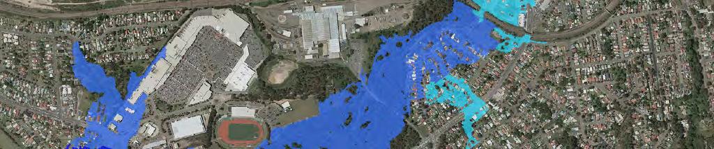
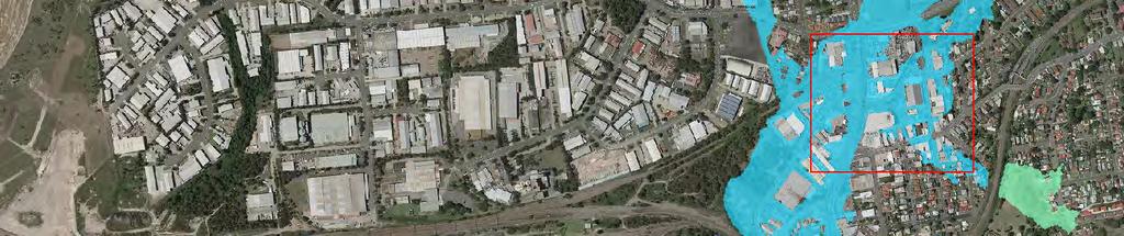
1 FIGURE 4B HISTORICAL FLOOD LEVELS NON CALIBRATION EVENTS Winding Creek Catchment Non Calibration Events Levels in m AHD J:\Jobs\111010\Arcview\ArcMaps\Figure04B_HistoricAlFloodLevels_NonCalibration.mxd Km
2 FIGURE 5 PHOTOGRAPHS OF CREEK SYSTEM Photo 1: Past the end of Gimbert St Photo 2: Pedestrian bridge at Elizabeth St looking south Photo 3: Bridge over creek at John St Photo 4: Pendlebury Rd Photo 5: Lachlan Rd, opposite John St Photo 6: Gorleston Tce Photo 7: Looking south under Munibung Rd Photo 8: Rail bridge near Sturt Rd J:\Jobs\111010\Working\Figure05_W WindingCreek_Photographs.pptx Photo 9: End of Sturt Rd, looking east Photo 10: Myall Rd Photo 11: Fern Valley Rd Photo 12: Wansbeck Valley Rd looking north towards Fern Valley Rd Photo 13: Alfred St Photo 14: Graham St looking north Photo 15: Frederick St bridge looking west Photo 16: Near Frederick St
3 4.5 J:\Jobs\111010\Hydrology\WATER_LEVELS.xlsx Barnsley Weir Cockle Creek Railway Bridge Level (m AHD) L FIGURE 6 WATER LEVEL GAUGE RECORDS
4 J:\Jobs\111010\Hydrology\WATER_LEVELS.xlsx Railway Bridge Third St Seventh St CC East side Five Is Bridge Note: Only levels along main channel shown Railway Bridge gauge < June Level (m AHD) Railway Bridge gauge < Feb Railway Bridge gauge < April Chainage (m) from confluence With Winding Creek FIGURE 7A HISTORICAL PEAK HEIGHT RECORDS COCKLE CREEK
5 J:\Jobs\111010\Hydrology\WATER_LEVELS.xlsx Hillsborough Rd Fifth St Newcastle St Myall Rd Harrison St Macquarie Rd Railway Bridge Wetland Weir Frederick St Note: Only levels along main channel shown 20 Level (m AHD) Chainage (m) from Hillsborough Road FIGURE 7B HISTORICAL PEAK HEIGHT RECORDS WINDING CREEK
6 Water Level (m) THIS WAS DIGITISED FROM HWC WINDING CREEK HYDROLOGY NOVEMBER FEBRUARY 1990 Water Level (m) THIS WAS DIGITISED FROM HWC WINDING CREEK BASIN ASSESSEMENT OCTOBER 2001 Fourth Street 10 APRIL 2001 Modelled Barnsley Weir Cockle Creek Railway Bridge Marmong Point Modelled (CC_Rail) FIGURE 8 STAGE HYDROGRAPHS 7-9 JUNE Assumed Sturt Road Modelled Time (min) FEBRUARY 1990 Water Level (m) THIS WAS DIGITISED FROM HWC WINDING CREEK BASIN ASSESSEMENT OCTOBER 2001 Sturt Road 10 APRIL 2001 Modelled Level (m AHD) J:\Jobs\111010\Hydrology\WATER_LEVELS.XLSX Level (m AHD) Barnsley Weir Cockle Creek Railway Bridge Marmong Point Modelled (CC_Rail) Level (m AHD) Barnsley Weir Cockle Creek Railway Bridge Modelled (CC_Rail) 10 APRIL
7 FIGURE 9A PLUVIOMETER DATA FEBRUARY 1990, APRIL 2001, JUNE Barnsley (1990) Hunter Water (1990) R3 Cardiff (2001) R5 Charlestown (2001) R10 Lookout Res (2001) Barnsley (2007) 350 R7 Teralba (2007) R11 Swansea (2007) R14 Wallsend (2007) R38 Hamilton (2007) R39 Kotara (2007) TR99 (2007) TR100 Eleebana (2007) TR101 Valentine (2007) 300 TR102 Belmont (2007) TR103 Belmont (2007) TR104 Redhead (2007) TR105 Windale (2007) TR106 Dudley (2007) TR107 Swansea (2007) 250 Cumulative Rainfall (mm) J:\Jobs\111010\Hydrology\Pluviometer_Data.xlsx Time (Hours)
8 J:\Jobs\111010\Hydrology\WBNM\Model_SetUp_WC 100 Total Rainfall Depth (mm) Dudley Kotara Teralba Eleebana Barnsley Design-100y (9h) Design-100y (2h) Design-500y (9h) Design-500y (2h) Time FIGURE 9B RAINFALL HYETOGRAPHS
9 J:\Jobs\111010\Hydrology\1990_Pluvio\IFD_Bursts_MACRO_1990.xlsx y ARI 50y ARI 20y ARI 10y ARI 5y ARI 2y ARI 1y ARI Intensity (mm/h) 10 1 Hunter Water (1990) Barnsley (1990) R3 Cardiff (2001) 30m 1hr 2hr 3hr 4.5hr 6hr 9hr 12hr 18hr 24hr 48hr 72hr Burst duration FIGURE 10 BURST INTENSITIES AND FREQUENCIES FEBRUARY 1990 AND APRIL 2001
10 J:\Jobs\111010\Hydrology\IFD_Bursts_MACRO_2007.xlsx y ARI 200y ARI 100y ARI 50y ARI 20y ARI 10y ARI 5y ARI 2y ARI 1y ARI 2000y ARI 1000y ARI Intensity (mm/h) 10 1 Barnsley R7 Teralba R14 Wallsend R38 Hamilton R39 Kotara TR100 Eleebana TR101 Valentine TR105 Windale TR106 Dudley 30m 1hr 2hr 3hr 4.5hr 6hr 9hr 12hr 18hr 24hr 48hr 72hr Burst duration FIGURE 11 BURST INTENSITIES AND FREQUENCIES JUNE 2007
11 FIGURE 12 WBNM HYDROLOGIC MODEL LAYOUT Creeks Lower Cockle Creek Tributary Burkes Creek Tributary Cocked Hat Creek Tributary Cockle Creek Tributary Flaggy Creek Tributary Winding Creek Tributary WBNM Lag Parameter C Km J:\Jobs\111010\Arcview\ArcMaps\Figure12_WBNMHydrologicModelLayout.mxd


12 FIGURE 13A COMPARISON OF PEAK LEVELS UPSTREAM WINDING CREEK JUNE Path: J:\Jobs\111010\Arcview\Calibration\ArcMaps\Figure13A_Winding_Creek_Upstream_Comparison_of_Peak_Levels_June2007_Ele.mxd Peak Flood Level (mahd) < > 35 Observed Flood Level Difference Modelled v Recorded ,000 m

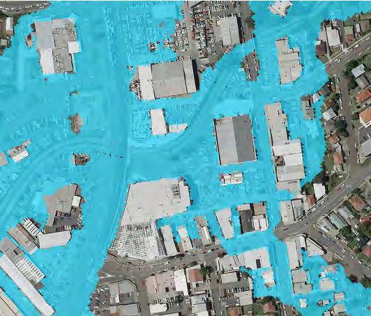
13 FIGURE 13B COMPARISON OF PEAK LEVELS DOWNSTREAM WINDING CREEK JUNE Path: J:\Jobs\111010\Arcview\Calibration\ArcMaps\Figure13B_Winding_Creek_Downstream_Comparison_of_Peak_Levels_June2007_Ele.mxd Peak Flood Level (mahd) < > 35 Observed Flood Level Difference Modelled v Recorded ,000 m
Hydrology of Recent Flooding in South East Queensland
 Hydrology of Recent Flooding in South East Queensland G. Hausler TOPICS Prelude eu e Rainfalls Catchments Flooding Aftermath Prelude Sea Surface Temperature anomalies for December 2010 Most likely return
Presented by: Greg D Jones Senior Sustainability Officer (Natural Disaster Management) City of Lake Macquarie New South Wales Australia
 City of Lake Macquarie New South Wales Australia") The June 2007 Holiday Weekend Storm/Flood Event in the City of Lake Macquarie, State of New South Wales, Australia Lessons Learnt in the Ensuing Years and Risk Reduction Management Actions Implemented
The June 2007 Holiday Weekend Storm/Flood Event in the City of Lake Macquarie, State of New South Wales, Australia Lessons Learnt in the Ensuing Years and Risk Reduction Management Actions Implemented
West Wallsend to Glendale & University servicing Seahampton, Holmesville, Killingworth, Barnsley, Edgeworth, Glendale, Cardiff, Wallsend, Jesmond &
 267 268 West Wallsend to Glendale & University servicing Seahampton, Holmesville, Killingworth, Barnsley, Edgeworth, Glendale, Cardiff, Wallsend, Jesmond & Newcastle How to use this timetable This timetable
Cau River. Map of River. Table of Basic Data. Vietnam 5
 Cau River Map of River Table of Basic Data Name: Cau River Location: Thai Nguyen, Province, Viet Nam Area: 6,030 km 2 Origin: Mt. Phia Deng 1,527 m Outlet: Pha Lai Note: * Indicates missing data in some
Western Transport Initiative (WesTrans) Concept Proposal
 Concept Proposal") Western Transport Initiative (WesTrans) Concept Proposal includes Western Education Link Line (WELL) and Commuter Clipper Buses A Proposal for Transport Integration Prepared by Save Our Rail NSW Inc. 11
Western Transport Initiative (WesTrans) Concept Proposal includes Western Education Link Line (WELL) and Commuter Clipper Buses A Proposal for Transport Integration Prepared by Save Our Rail NSW Inc. 11
Cardiff Street Names By Clive Read 2003
 Cardiff Street Names By Clive Read 2003 Ada Street An 1889 street, the landowners were Samuel Quintral or Michael MacNamara. Adelphi Lane One end of this lane leads to a pedestrian overhead railway crossing
Introduction. The System. Model Limitations, Assumptions, and Parameters. Optional Services Tech Memo
 Optional Services Tech Memo Introduction This technical memo evaluates the impact of a tide gate to be installed at the confluence of the Left Bank Tributary of Thalia Creek and Lake Windsor. Specifically,
Table of Contents. Overview 4. Acknowledgements 5. Summary 6. Belmont 15. Cardiff 20. Charlestown 25. Glendale 30. Morisset 35.
 Commercial Centre Study 2012 Disclaimer While every reasonable effort has been made to ensure that this document is correct at the time of publication, Lake Macquarie City Council, its agents and employees,
Development of a MIKE11 Model of the Danube, Tisa and Sava Rivers in Serbia
 Development of a MIKE11 Model of the Danube, Tisa and Sava Rivers in Serbia Vasiljka KOLAROV*, Marina BABIĆ MLADENOVIĆ*, Zoran KNEŽEVIĆ*, Martin MIŠIK** * Jaroslav Černi Institute, Department for River
HYDRAULIC DESIGN OF THE TOURISTIC BERTHING IN ASWAN CITY
 HYDRAULIC DESIGN OF THE TOURISTIC BERTHING IN ASWAN CITY Dr. Hossam El-Sersawy Researcher, Nile Research Institute (NRI), National Water Research Center (NWRC), Egypt E-mail: h_sersawy@hotmail.com Dr.
Item 1 Ryhope Paper Subdivision
 Item 1 Ryhope Paper Subdivision Item 1 Ryhope Paper Subdivision Address (the site) 3, 5, 7,9 10-22, 24, 25, 28, 35-40, 42, 44, 46, 48 Charles Street, Ryhope 4, 6, 8, 10, 12, 14, 16, 18, 20, 22-28, 30,
Hydrology Input for West Souris River IWMP
 Hydrology Input for West Souris River IWMP Prepared by: Mark Lee Manitoba Water Stewardship 1 1 1 Overall view of: drainage area watershed characteristics gauging stations meteorological stations Runoff
Public Toilet Facilities Strategy Adopted by Council 27 June 2011
 Public Toilet Facilities Strategy Adopted by Council 27 June 2011 1 Table of Contents Introduction 4 Rationale of study 4 Project objectives 5 Methodology 5 Literature review 5 Planning requirements 6
Belmont to Newcastle servicing Jewells, Gateshead, Charlestown, Kotara, Glebe & The Junction. newcastletransport.info
 14 to servicing Jewells, Gateshead, Charlestown, Kotara, Glebe & The Junction newcastletransport.info How to use this timetable This timetable provides a snap shot of service information in 24-hour time
GOOSENECK SWAMP INFORMATION DAY - Saturday 14 th December 2013
 GOOSENECK SWAMP INFORMATION DAY - Saturday 14 th December 2013 Progress of a restoration trial at Gooseneck Swamp - Grampians National Park, Victoria Gooseneck Swamp is situated at the far south-eastern
Jeneberang River. Serial No. : Indonesia-10 Location: South Sulawesi Area: 727 km 2 Origin: Mt. Bawakaraeng (2,833 MSL) Outlet: Makassar Strait
 Outlet: Makassar Strait") Jeneberang River Map of River Table of Basic Data Name: Jeneberang River Serial No. : Indonesia-10 Location: South Sulawesi S 5 10' 00" - 5 26' 00" E 119 23' 50" - 119 56' 10" Area: 727 km 2 Origin: Mt.
Jeneberang River Map of River Table of Basic Data Name: Jeneberang River Serial No. : Indonesia-10 Location: South Sulawesi S 5 10' 00" - 5 26' 00" E 119 23' 50" - 119 56' 10" Area: 727 km 2 Origin: Mt.
Wilts & Berks Canal. Appendix E: Hydrology and Hydraulics CONTENTS 1. INTRODUCTION 2 2. HYDROLOGY 2 3. HYDRAULIC MODEL 2 4.
 Wilts & Berks Canal Melksham River Route Study Appendix E: Hydrology and Hydraulics CONTENTS 1. INTRODUCTION 2 2. HYDROLOGY 2 3. HYDRAULIC MODEL 2 4. CANAL OPERATION 3 5. WEIR DESIGN 4 6. FLOOD RISK 5
Council Venue Hire Fees /2015
 Council enue Hire Fees - 2014/2015 rices are indicitive only. lease contact Screen Hunter for a detailed quote. C - general conditions - venue S - sports T - traffic control/management - park Administration
LESOTHO HIGHLANDS DEVELOPMENT AUTHORITY
 LESOTHO HIGHLANDS DEVELOPMENT AUTHORITY ANNUAL FLOW RELEASES INSTREAM FLOW REQUIREMENT (IFR) IMPLEMENTATION AND MONITORING (October 2004 to September 2005) TOWER ON MALIBAMATŠO RIVER @ KAO REPORT N0.6
The Problem.. SuDS: Controlling the Flow. LANDF RM Technical delivery of SuDS 15/10/2013. Bridget Woods Ballard HR Wallingford 1.
 SuDS: Controlling the Flow 15th October 2013 Bridget Woods Ballard The Problem.. Page 2 Bridget Woods Ballard HR Wallingford 1 15th October 2013 Landform Event Page 3 HR Wallingford 2013 The Aim of SuDS.
The search results explanations of hydrological data
 Introduction The search results explanations of hydrological data Depending on the parameter, the instrumental measuring or visual observation method is used for the hydrological observations. Instrumentally
How to develop resilient infrastructure (Global SDG9)
") How to develop resilient infrastructure (Global SDG9) 16-17 November 2017, Ljubljana, Slovenia Development of resilient rail infrastructure, practices in the Republic of Macedonia Darko Miceski Viktorija
How to develop resilient infrastructure (Global SDG9) 16-17 November 2017, Ljubljana, Slovenia Development of resilient rail infrastructure, practices in the Republic of Macedonia Darko Miceski Viktorija
II. THE BOULDER CREEK DRAINAGE BASIN
 II. THE BOULDER CREEK DRAINAGE BASIN This section provides an overview of the watersheds and flood hazards associated with Boulder Creek and South Boulder Creek including descriptions of the drainage basins,
HILLSBOROUGH COUNTY, FLORIDA AND INCORPORATED AREAS
 VOLUME 2 OF 5 HILLSBOROUGH COUNTY, FLORIDA AND INCORPORATED AREAS Hillsborough County COMMUNITY NAME COMMUNITY NUMBER HILLSBOROUGH COUNTY (UNINCORPORATED AREAS) 120112 PLANT CITY, CITY OF 120113 TAMPA,
When the preventative evacuation of Orléans can be decided on before a flood?
 When the preventative evacuation of Orléans can be decided on before a flood? GOUTX David (et al.) Loire flood-forecasting service 1/25 Major floods: a major issue for the Loire valley 2/25 Major floods:
Natural Factors Affecting the Level of Osoyoos Lake
 Natural Factors Affecting the Level of Osoyoos Lake Background Osoyoos Lake is operated under conditions prescribed by the International Joint Commission (IJC) and Figure 1 shows the ranges within which
Watershed Runoff Analysis
 CREATING SOLUTIONS FOR A CHANGING WORLD Watershed Runoff Analysis April 18, 2017 John Melack, UCSB Ed Beighley & Dongmei Feng, Northeastern University Study Workflow Civil and Environmental Engineering
Committee Room, Lake Macquarie City Council Administration Building, Speers Point
 Lake Macquarie Sustainable Neighbourhood Alliance Ordinary Meeting MINUTES Tuesday 21 March 2017, 6.00-8.00pm Committee Room, Lake Macquarie City Council Administration Building, Speers Point Present:
Design and Construction of the Lake St. Martin Emergency Outlet
 Design and Construction of the Lake St. Martin Emergency Outlet Background 2011 was the largest flood event experienced in the last 200 years Flood Fighting required some difficult decisions by the Manitoba
Name: Watarase-gawa N ~ Length of main stream: 108 km
 Japan 9 Watarase-gawa Map of River Table of Basic Data Name: Watarase-gawa Location: Central Honshu, Japan 2 Serial No.: Japan-9 N 36 9 ~ 36 44 E 139 12 ~ 139 52 Area: 2 62 km Length of main stream: 18
Hydrological Analysis for Simanggo-2 HEPP
 Part 15 Hydrological Analysis for Simanggo-2 HEPP PART 15 HYDROLOGICAL ANALYSIS FOR SIMANGGO-2 HEPP 15.1 METEOROLOGY AND HYDROLOGY Meteorological Records and Hydrological Records are collected from Meteorological
CCN. Central Coast & Newcastle Line. How to use this timetable. Real-time planning. Explanation of definitions and symbols. Accessible services.
 Central Coast & Newcastle Line How to use this timetable This timetable provides a snap shot of service information in 24-hour time (e.g. 5am = 05:00, 5pm = 17:00). Information contained in this timetable
Central Coast Hunter Range Region Discovery Program
 Central Coast Hunter Range Region Discovery Program Sydney to Newcastle General Inquiries NPWS (02) 4320 4200 (Monday - Friday) Detailed Information Anne Whyte, Discovery Coordinator NPWS (02) 4320 4205
FLOW REDUCTION IMPACTS ALONG RIVER NILE IN EGYPT
 FLOW REDUCTION IMPACTS ALONG RIVER NILE IN EGYPT Sherine S. Ismail Prof., Head of Lake Nasser studies department, Nile Research Institute, E-mail:sherine_shawky@yahoo.com ABSTRACT Nile water discharges
$6.60 NEW SOUTH WALES. Both METRIC and Feet and Inches TIMES: am/pm Sunrise/Sunset Moon Phases Moon Rise/Set DIARY NOTES.
 $6.60 (incl. GST) 2019 2014 November 28, 2013 November 22, 2018 TO to January 1, 7, 2020 2015 Both METRIC and Feet and Inches TIMES: am/pm Sunrise/Sunset Moon Phases Moon Rise/Set DIARY NOTES NEW SOUTH
International Sava River Basin Commission
 International Sava River Basin Commission Pilot project on climate change: Building the link between the Flood Risk Management planning and climate change assessment in the Sava River Basin climate change
"Transboundary coordination according to the FD Directive in the shared river basins of Greece
 Workshop on Transboundary Issues Budapest March 31st April 1st "Transboundary coordination according to the FD Directive in the shared river basins of Greece Katerina Triantafyllou, ECOS Consulting S.A.
Lake Mac Trails Your Councillors Save money on electricity Green Waste Service Our child care services Become an Eco Angel
 Lake Mac Trails Your Councillors Save money on electricity Green Waste Service Our child care services Become an Eco Angel Getting to know your Council Last year s local government election delivered significant
Glaciology. Water. Glacier. Moraine. Types of glacier-dammed lakes. Mechanics of jökulhlaup
 A Jökulhlaup Jökulhlaup. Catastrophic events where large amounts of water are suddenly discharged. Jökulhlaup s are a sudden and rapid draining of a glacier dammed lake or of water impounded within a glacier.
Charlestown to Newcastle servicing John Hunter Hospital, Jesmond, Waratah, Mayfield & City West. newcastletransport.info
 Charlestown to servicing John Hunter Hospital, Jesmond, Waratah, Mayfield & City West newcastletransport.info How to use this timetable This timetable provides a snap shot of service information in 24-hour
NEW SOUTH WALES. Both METRIC and Feet and Inches TIMES: am/pm Sunrise/Sunset Moon Phases Moon Rise/Set DIARY NOTES.
 2016 2014 November 28, 2013 November 26, 2015 TO to January 4, 7, 2017 2015 Both METRIC and Feet and Inches TIMES: am/pm Sunrise/Sunset Moon Phases Moon Rise/Set DIARY NOTES NEW SOUTH WALES Public Works
Hunter Water Corporation Media Release
 Hunter Water Corporation Media Release Wednesday 8 January 2014 HUNTER WATER INCREASES CUSTOMER REBATE A decision 2 years ago to adjust how Hunter Water compensates customers affected by lengthy emergency
Investigation of River Stage Simulation Before and After Bengoh Dam Construction: Case Study of Sarawak River Basin Malaysia
 International Journal of Science and Engineering Investigations vol. 4, issue 42, July 2015 ISSN: 2251-8843 Investigation of River Stage Simulation Before and After Bengoh Dam Construction: Case Study
LESOTHO HIGHLANDS DEVELOPMENT AUTHORITY
 LESOTHO HIGHLANDS DEVELOPMENT AUTHORITY ANNUAL FLOW RELEASES INSTREAM FLOW REQUIREMENT (IFR) IMPLEMENTATION AND MONITORING (October 2005 to September 2006) REPORT N0.7 OCTOBER 2007 STRATEGIC AND CORPORATE
$6.60 NEW SOUTH WALES. Both METRIC and Feet and Inches TIMES: am/pm Sunrise/Sunset Moon Phases Moon Rise/Set DIARY NOTES.
 $6.60 (incl. GST) 2018 2014 November 28, 2013 November 23, 2017 TO to January 2, 7, 2019 2015 Both METRIC and Feet and Inches TIMES: am/pm Sunrise/Sunset Moon Phases Moon Rise/Set DIARY NOTES NEW SOUTH
Long term morphological analysis and simulations
 Long term morphological analysis and simulations Dr.-Ing. Markus Promny Bundesanstalt für Gewässerkunde / Federal Institute of Hydrology GESINUS 2010 - Liège - 29./30.07.2010 page 1 1D-models of German
SECTION 3 GENERAL DESCRIPTION OF THE RIVER BASIN
 SECTION 3 GENERAL DESCRIPTION OF THE RIVER BASIN SECTION 3 GENERAL DESCRIPTION OF THE RIVER BASIN River basin description. A general description of the river basin or subbasin, as appropriate, in which
WALKER SWAMP INFORMATION DAY Saturday 23 rd June 2018
 WALKER SWAMP INFORMATION DAY Saturday 23 rd June 2018 Introduction to the Upper Wannon River Floodplain wetlands and the new Walker Swamp Restoration Reserve Mark Bachmann and Greg Kerr, Nature Glenelg
Why the amending plan is suitable to be made in accordance with section 73A:
 NSW GOVERNMENT Department of Planning DOP file no:.. Section 73A EP&A Act submission Part A. Council to complete Subject: Lake Macquarie City Council Local Environment Plan 2014 (LMLEP 2014) Heritage Schedule
Hydraulic Report. Trail 5 Snowmobile Trail Over Mulligan Creek. Prepared By: COLEMAN ENGINEERING COMPANY Karisa V. Falls, P.E.
 Prepared for: Prepared by: Marquette County Road Commission Coleman Engineering Company Marquette, Michigan Iron Mountain, MI December 2011 Hydraulic Report Trail 5 Snowmobile Trail Over Mulligan Creek
Mark West Creek Flow Study Report
 Mark West Creek Flow Study Report Biology and Geology of Mark West Creek The headwaters of Mark West Creek are located in the Mayacamas Mountain range, which border Napa and Sonoma County, where it then
Outcome 3: Deliver housing close to jobs and services
 Outcome 3: Deliver housing close to jobs and services Greater Newcastle has established from the independent development of original towns like Maitland, Wallsend, Newcastle, Raymond Terrace, Cessnock
Update on FLOODS in Nigeria
 EUROPEAN COMMISSION JOINT RESEARCH CENTRE Update on FLOODS in Nigeria JRC Emergency Report #021 Nigeria, 19th of September 2018 Executive Summary The National Emergency Management Agency (NEMA) informs
Kurobegawa No.4 Power Plant Toyama Prefecture, Japan (Asia)
") IEA Hydropower Implementing Agreement Annex VIII - Hydropower Good Practices: Environmental Mitigation Measures and Benefits Case Study 14-02: Development of Regional Industries Kurobegawa No.4 Power Plant,
IEA Hydropower Implementing Agreement Annex VIII - Hydropower Good Practices: Environmental Mitigation Measures and Benefits Case Study 14-02: Development of Regional Industries Kurobegawa No.4 Power Plant,
superseded by 2008 nhc report
 Steveston North Jetty Steveston South Jetty Georgia Strait Middle Arm West Vancouver UEL Legend Vancouver North Vancouver City North Arm Richmond Canoe Pass Fraser Valley Regional District North Vancouver
Introduction. Background MEMORANDUM
 MEMORANDUM Date: July 22, 2014 To: H&H Technical Committee From: Bob Elliot and Larry Karpack, Watershed Science & Engineering Cc: Bob Montgomery, Anchor QEA Re: Chehalis Basin Strategy: Reducing Flood
Coastal Wetlands Park
 Lake Macquarie Coastal Wetlands Park Coastal Wetlands Natural areas and corridors Urban Areas Rev04 INTRODUCTION The establishment of a, encouraged by active Landcarers throughout the region, would recognise
AN OUTLINE OF THE NILE BASIN
 The Hydrology of the Nile by J. V. Sutcliffe & Y. P. Parks. IAHS Special Publication no. 5, 1999. CHAPTER 1 AN OUTLINE OF THE NILE BASIN INTRODUCTION The hydrology of the Nile basin cannot be understood
4. Hydrology of the Olentangy River Watershed
 4. Hydrology of the Olentangy River Watershed The Hydrologic Cycle Water on Planet Earth is dynamic constantly being recycled from the land to the atmosphere to the ocean. Rivers and streams are just a
This area is a popular holiday spot so watch out for 4WD vehicles and motorbikes at peak times.
 Mavora Walkway (Map 130, 129, 128) Southern Start Northern End Distance Time Track Standard Mavora Camping Area, Mavora Lakes Road Greenstone Station Road Carpark 50km 3 days Tramping track Hazards Never
EO technologies for flood mapping and hydrological modelling in Namibia
 Satellite Earth Observation & Disaster Risks EO technologies for flood mapping and hydrological modelling in Namibia Guido Van Langenhove, Hydrological Services Namibia Hydrological trends in Namibia:
AMENDMENTS TO THE DECISION 14/12 ON ADOPTION OF CLASSIFICATION OF THE SAVA RIVER WATERWAY
 Conscious of the importance of the Sava River for the economic, social and cultural development of the region, Desirous of development of the inland navigation on the Sava River, Having regard to the European
Thailand 12. Pasak River. Map of River
 Pasak River Map of River 232 Table of Basic Data Name: Pasak river Serial No. : Thailand-12 Location: Central part of Thailand N 14 21' 44" ~ 17 06' 02" E 100 34' 40" ~ 101 32' 56" Area: 15,779 km 2 Length
Hydrological study for the operation of Aposelemis reservoir Extended abstract
 Hydrological study for the operation of Aposelemis Extended abstract Scope and contents of the study The scope of the study was the analytic and systematic approach of the Aposelemis operation, based on
SLV POWER PRIVATE LIMITED ANIYUR MINI HYDEL SCHEME (3 X 8 MW = 24 MW) CATCHMENT AREA TREATMENT PLAN
 CATCHMENT AREA TREATMENT PLAN") SLV POWER PRIVATE LIMITED ANIYUR MINI HYDEL SCHEME (3 X 8 MW = 24 MW) CATCHMENT AREA TREATMENT PLAN 1. INTRODUCTION : M/s SLV Power Pvt. Ltd. Is setting up a Mini Hydel Scheme of 24 MW capacity across
SLV POWER PRIVATE LIMITED ANIYUR MINI HYDEL SCHEME (3 X 8 MW = 24 MW) CATCHMENT AREA TREATMENT PLAN 1. INTRODUCTION : M/s SLV Power Pvt. Ltd. Is setting up a Mini Hydel Scheme of 24 MW capacity across
MEMORANDUM. Immediate Report Final April 17-18, 2016 (Tax Day) Storm and Flood Information
 Storm and Flood Information") MEMORANDUM DATE: June 27, 2016 TO: FROM: HCFCD Flood Watch/Partners Jeff Lindner Meteorologist / Flood Watch Manager Steve Fitzgerald Flood Watch Leader 9900 Northwest Freeway Houston, TX 77092 713-684-4000
MEMORANDUM DATE: June 27, 2016 TO: FROM: HCFCD Flood Watch/Partners Jeff Lindner Meteorologist / Flood Watch Manager Steve Fitzgerald Flood Watch Leader 9900 Northwest Freeway Houston, TX 77092 713-684-4000
THE ICs INTERNATIONAL BRISBANE AREA AQUA PARK PROPOSAL
 Contacts: Mr Evan Pryor, Ph 38702756, evanpryor2002@yahoo.com.au Mr Bob Beatty, Ph 32883101, BobBeatty@BOSMIN.com Web Address: http://www.bosmin.com/ics/icharter.htm Postal Address: GPO Box 2927, Brisbane,
Internationales Symposion INTERPRAEVENT 2004 RIVA / TRIENT
 Internationales Symposion INTERPRAEVENT 2004 RIVA / TRIENT THREAT OF TORRENTS TO THE LANDSCAPE THREAT OF IN THE TORRENTS CZECH TO REPUBLIC THE LANDSCAPE IN THE CZECH REPUBLIC Jiri Belsky, Katerina Trejbalova,
Estimation of Glacier Lake Outburst Flood and its Impact on a Hydro Project in Nepal
 Snow and Glacier Hydrology (Proceedings of the Kathmandu Symposium, November 1992). IAHSPubl. no. 218,1993. 331 Estimation of Glacier Lake Outburst Flood and its Impact on a Hydro Project in Nepal G. MEON
Thirteenth International Water Technology Conference, IWTC , Hurghada, Egypt 1249
 Thirteenth International Water Technology Conference, IWTC 13 2009, Hurghada, Egypt 1249 EVALUATION OF LOCAL SCOUR AROUND BRIDGE PIERS (RIVER NILE BRIDGES AS CASE STUDY) Sherine Ismail Assoc. Prof., Survey
International Sava River Basin Commission
 International Sava River Basin Commission Pilot project on climate change: Building the link between the Flood Risk Management planning and climate change assessment in the Sava River Basin - climate change
SECTION BOULDER COUNTY ROUTINE STREAM MANAGEMENT MASTER SCHEDULE
 SECTION 01320 COUNTY ROUTINE STREAM MANAGEMENT MASTER SCHEDULE CONTRACTOR: VALLES CONSTRUCTION AGREEMENT NO. 18-01.05 Week starting on Monday of: BEAR CANYON CREEK Reach: Moorhead to Lehigh St. CREEK -
Final Drainage Letter Pikes Peak Community College Downtown Parking Lot Colorado Springs, Colorado
 Final Drainage Letter Pikes Peak Community College Downtown Parking Lot Colorado Springs, Colorado Prepared for: Pikes Peak Community College 5775 South Academy Boulevard Colorado Springs, CO 80906-5422
HYDRAULIC STUDY OF THE NERETVA RIVER (FROM MOSTAR TO THE BORDER WITH THE REPUBLIC OF CROATIA)
") HYDRAULIC STUDY OF THE NERETVA RIVER (FROM MOSTAR TO THE BORDER WITH THE REPUBLIC OF CROATIA) B.Sc. Draženka Kvesić, civ. eng. PRONING DHI d.o.o., Račkog 3, Zagreb Croatia. Email: drazenka@proning-dhi.hr.
HYDRAULIC STUDY OF THE NERETVA RIVER (FROM MOSTAR TO THE BORDER WITH THE REPUBLIC OF CROATIA) B.Sc. Draženka Kvesić, civ. eng. PRONING DHI d.o.o., Račkog 3, Zagreb Croatia. Email: drazenka@proning-dhi.hr.
Ian Manock Australian Graduate School of Policing Charles Sturt University. Examining the resilience of rural communities to flooding emergencies
 Ian Manock Australian Graduate School of Policing Charles Sturt University Examining the resilience of rural communities to flooding emergencies Research Team Professor John Hicks - (School of Business)
SAN ANTONIO RIVER IMPROVEMENTS PROJECT. August 6, 2008
 SAN ANTONIO RIVER IMPROVEMENTS PROJECT August 6, 2008 1 History of the SA River Improvements 1921 Flood Olmos Dam Complete in 1929 Downtown Flood Relief Projects in 1950 s Dams on the River Channel and
Bishop Tyrrell Anglican College. Morning. Shift Route Time From Bus Route H :51 Bolwarra,
 H237 2371 6:51, Heights Heights: Via Dalveen, L> April, R> Betula, R> Maple, R> Dalveen, R> Corina, R> Paterson, R> Largs - 7:01 - L> Church, R> High, R> Largs, R> Paterson, L> Lang, L> Tocal - Heights
THE FORUM SHOPPING CENTRE WALLSEND, NE28 8JR
 THE FORUM SHOPPING CENTRE THE FORUM SHOPPING CENTRE TOWN CENTRE STATISTICS 418,651 14.9m p.a. 4,742 p.a. 35-44 13 mins drive time 16 mins train time total retail catchment comparison goods spend average
Duncan Hastie, P.E. Dewberry
 FEMA s Riverine High Water Marks for Atlanta s September 2009 Flood Event Duncan Hastie, P.E. Dewberry Background High Water Mark Recovery Performed Through FEMA s Hazard Mitigation Technical Assistance
Extraordinary summer flood in a karst area: case study in Croatia
 The Extremes ofthe Extremes: Exlraordinan' Floods (Proceedings ol'a symposium held at Reykjavik. Iceland. July 2000). IAHS Publ. no. 271. 2002. 133 Extraordinary summer flood in a karst area: case study
Hawke s Bay Regional Parks Network. Pekapeka Regional Park Individual Park Plan
 Hawke s Bay Regional Parks Network Pekapeka Regional Park Individual Park Plan 2015-2024 Hawke s Bay Regional Council 159 Dalton Street Private Bag 6006 Napier 4110 Hawke s Bay New Zealand Telephone: 0800
130,000 SQ FT OF ENVIABLE OFFICES LANDMARK GRADE A OFFICE DEVELOPMENT IN AN EXCELLENT CITY CENTRE LOCATION CLICK TO ENTER
 130,000 SQ FT OF ENVIABLE OFFICES LANDMARK GRADE A OFFICE DEVELOPMENT IN AN EXCELLENT CITY CENTRE LOCATION CLICK TO ENTER WELCOME TO DIGITAL CAMPUS SHEFFIELD SHEFFIELD S1 2BJ INTRODUCTION The latest phase
PORTISHEAD BRANCH LINE PRELIMINARY ENVIRONMENTAL INFORMATION REPORT VOLUME 4 APPENDIX Water Receptors
 PORTISHEAD BRANCH LINE PRELIMINARY ENVIRONMENTAL INFORMATION REPORT APPENDIX 17. 3 Water Receptors Contents Section Page 1 Water Receptors... 1-1 1.1 Surface Water Features/Receptors in the Study Area
DEVON AND CORNWALL. The November 2012 Railway Flooding in Devon: Observations & Recommendations
 DEVON AND CORNWALL The November 2012 Railway Flooding in Devon: Observations & Recommendations The November 2012 Railway Flooding in Devon: Observations & Recommendations Gerard Duddridge Published by
Welcome KROSNO CREEK DIVERSION PROJECT CLASS ENVIRONMENTAL ASSESSMENT
 Welcome KROSNO CREEK DIVERSION PROJECT PUBLIC INFORMATION CENTRE # 1 Tonight s Presentation Study Overview Background Existing Conditions Alternative Solutions Preliminary Preferred Solution Next Steps
106,890 sq ft 9,930 sq m
 WESTERN APPROACH BRISTOL BS35 4GG TO LET/FOR SALE B2/B8 OPPORTUNITY 106,890 sq ft 9,930 sq m IMMEDIATELY AVAILABLE FOR OCCUPATION A BRAND NEW DISTRIBUTION WAREHOUSE/MANUFACTURING UNIT ON THE SOUTH WEST
A pilot flood retention area in La Bassée
 A pilot flood retention area in La Bassée Institution interdépartementale des barrages-réservoirs du bassin de la Seine 8, rue Villiot - 75012 Paris - Tél. : 01 44 75 29 29 - Télécopie : 01 44 75 29 30
MANAGING FRESHWATER INFLOWS TO ESTUARIES
 MANAGING FRESHWATER INFLOWS TO ESTUARIES Yuna River Hydrologic Characterization A. Warner Warner, A. (2005). Yuna River Hydrologic Characterization. University Park, Pennsylvania: The Nature Conservancy.
Connect Transform Locate
 A modern business space for modern business, located within an integrated transport hub. Up to 29,052 sq ft New Build Grade A BREEAM rated excellent Office accommodation. Wolverhampton. Making it happen
Wallsend & Jesmond to Newcastle East
 Description of routes in this timetable Route 222 Wallsend to Newcastle East via Elermore Vale, New Lambton Heights, John Hunter Hospital, New Lambton, Broadmeadow, Hamilton and Newcastle West. Service
STUDY OF HISTORICAL FLOODS IN CENTRAL AND EASTERN EUROPE FROM AN INTEGRATED FLOOD MANAGEMENT VIEWPOINT SLOVAKIA
 World Meteorological Organization STUDY OF HISTORICAL FLOODS IN CENTRAL AND EASTERN EUROPE FROM AN INTEGRATED FLOOD MANAGEMENT VIEWPOINT SLOVAKIA Submitted by: Slovak Hydrometeorological Institute, Bratislava
SAN ANTONIO RIVER IMPROVEMENTS PROJECT. April 27, 2009
 SAN ANTONIO RIVER IMPROVEMENTS PROJECT April 27, 2009 1 Project Limits 2 Project Partners City of San Antonio Provides project funding for project amenities (i.e.. Sidewalks, Landscaping, Lighting, etc.)
Community resources management implications of HKH hydrological response to climate variability
 Community resources management implications of HKH hydrological response to climate variability -- presented by N. Forsythe on behalf of: H.J. Fowler, C.G. Kilsby, S. Blenkinsop, G.M. O Donnell (Newcastle
RE: Extreme Avalanche Hazard at New Jumbo Glacier Resort (JGR) Daylodge Building Site
 Daylodge Building Site") To: Ms. Autumn Cousins Manager, Policy and Compliance BC Environmental Assessment Office, via Email to autumn.cousins@gov.bc.ca and eao.compliance@gov.bc.ca PO Box 9426 Stn Prov Govt Victoria, BC V8W 9V1
To: Ms. Autumn Cousins Manager, Policy and Compliance BC Environmental Assessment Office, via Email to autumn.cousins@gov.bc.ca and eao.compliance@gov.bc.ca PO Box 9426 Stn Prov Govt Victoria, BC V8W 9V1
2014 floods in Serbia
 16 th Meeting of WGF, Rim, 9-10 October 2014 2014 floods in Serbia Radovanka Pavlović Ministry of Agriculture and Environmental Protection Republic Water Direcrorate, Belgrade, Serbia Specific cyclone
Proposal for a BLUE HAVEN Train and Bus Interchange
 Planning Public Transport In North Wyong On the Central Coast of NSW 2012 Proposal for a BLUE HAVEN Train and Bus Interchange By David Holland Community Environment Network (CEN) Sustainable Transport
Water resources cycle in karst (feasibility studies and engineering design; case studies)
") Water resources cycle in karst (feasibility studies and engineering design; case studies) Prof. emeritus Ognjen Bonacci Faculty of Civil Engineering, Architecture and Geodesy, Split University E-mail:
Water resources cycle in karst (feasibility studies and engineering design; case studies) Prof. emeritus Ognjen Bonacci Faculty of Civil Engineering, Architecture and Geodesy, Split University E-mail:
Cusco floods in 2010 Laura Paccini 1, Luis Orihuela 1
 WWOSC 2014 MONTRÉAL, CANADA Cusco floods in 2010 Laura Paccini 1, Luis Orihuela 1 1 Universidad Nacional Agraria La Molina Cusco Region Location Population Climate Southeast of Peru 11 10 15 20 S 70 10
MAURITIUS CANE INDUSTRY AUTHORITY MAURITIUS SUGARCANE INDUSTRY RESEARCH INSTITUTE
 MAURITIUS CANE INDUSTRY AUTHORITY MAURITIUS SUGARCANE INDUSTRY RESEARCH INSTITUTE Ref A 1/215 13 August 215 SUGAR CANE CROP 215 Status: End July 215 1. CLIMATE 1.1 Rainfall (Tables 1a and 1b, Figure 1)
Wetlands influencing river biogeochemistry: the case study of the Zambezi and the Kafue Rivers
 AFRIVAL Project (African River Basins) http://ees.kuleuven.be/project/afrival/ EGU General Assembly 2014, Vienna Wetlands influencing river biogeochemistry: the case study of the Zambezi and the Kafue