A pilot flood retention area in La Bassée
|
|
|
- Diane Atkinson
- 6 years ago
- Views:
Transcription


1 A pilot flood retention area in La Bassée Institution interdépartementale des barrages-réservoirs du bassin de la Seine 8, rue Villiot Paris - Tél. : Télécopie :
2 Flood risk in the Paris region

3 The 1910 flood in Paris


4 Flood risk in the Paris Region Flooded area for the 1910 flood 140 km of metro lines would be interrupted people flooded 2 M without electricity 2,7 M without water supply businesses would be affected A 1910 flood would cost more or less 30 to 40 billions


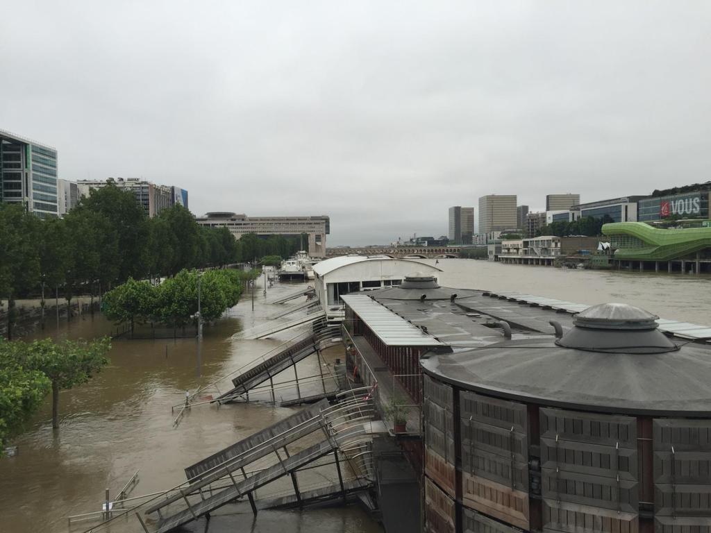
5 The 2016 june flood in Paris

6 The necessity of a new storage reservoir The existing storage reservoirs control only 17% of the river Seine catchement The river Yonne, one of the tributaries of the river Seine, gives quick and high flow peaks leading to high flood risks in Paris The dam located on the river Yonne controls only 2% of the Yonne catchment Need to mitigate the impact of the river Yonne on the flood risks downstream The only area available for an efficient mitigation of the Yonne flow peaks is the Bassée area, located at the confluence between the Seine and the Yonne rivers
7 La Bassée project

8 The downstream Bassée area o The downstream Bassée area is located at the confluence between the Seine and the Yonne Rivers in the Ile de France region La Bassée o The Bassée area used to be a flood plain for the river Seine before the 1960 s (flooded every 1-2 years)

9 The downstream Bassée area The Bassée area used to be a floodplain for the Seine river before the 1980 s (flooded every 1-2 years) but two major projects deeply altered its structure and hydrodynamics on its downstream part: 1-The local transformation of the river Seine into a shipping canal: o local decrease of the river level with no more sollicitation of the area as a floodplain o increase of the flood risks downstream o drainage of the area leading to a poorer ecosystem 2- Sand and gravel excavation: o random-located extraction sites o resulting holes filled with rain and groundwater
10


11 Two Objectives - hydraulic aspects : flood alleviation - ecologic s aspects 1

12 Concept: retaining part of the Seine river flow during Yonne flood peaks Pumping from the Seine river into the retention areas Flow decrease downstream from the confluence High flood event on the Yonne river
 o gravitary emptying into the river once the level has decreased (13 sluice gates) Estimated decrease in the water level of the")
13 Features and layout of the global project o 10 retention areas built by the means of shallow dykes (up to 4,70 m high) o a potential retention capacity of 55 Mm 3 ranged over 23 km 2 and 12 districts o 50 pumps with an overall capacity of 230 cumecs (7 pumping stations) o gravitary emptying into the river once the level has decreased (13 sluice gates) Estimated decrease in the water level of the river Seine: between 20 and 50 cm according to the cities location and the type of floods


14 A second goal: wetland restoration o The downstream Bassée area used to be a frequently flooded wetland. The area is Natura 2000 and Ramsar classified o The second goal of the project is to restore its dynamics of alluvial wetland o In particular the ecological project aims to restore the former flora and fauna biodiversity by : creation of spawning grounds, combat invasive species transform poplar plantations in wetlands monitoring of the species living in the area: evolution, number other actions of biodiversity improvement


15 La Bassée: a multi-functional area Flood alleviation 55 Mm3 Wetland classified Ramsar, Natura Mineral extraction Archeology and cultural heritage Water resources Agriculture and recreation green-blue
16 A first step : a pilot project


17 Global project How choose the pilot area - 10 retention area - 58 km of dikes ha of surface area - pumping capacity of 230 m 3 /s - capacity of 55 Millions m3 - Global cost : 600 Millions The choice d based on multi-factory analysis (technical, environnemental and uses approach), have been discused with stakehloder during a progressing process during 18 month Pilot project - 7,8 km of dikes - Capacity of 8,8 M. de m3-372 ha of surface area - pumping capacity of 34 m 3 /s - Global cost : 100 Millions


18 Principe de fonctionnement Management principle Pumping : 3 days Storage : 5 d approx. Draining : 15 d-1,5 month Water level : 2,5 m Frequency : 7 to 10 year in average

 Pumping station Storage compartment")
19 Why filling in the storage compartments by pumping? La Bassée floodplain used to be floodable every 1-2 years before the 80 s (Q>150 cumecs) In the 80 s the river Seine was transformed into a great template channel (Q>400 cumecs corresponding to the 1910 flood) Pumping station Storage compartment Pumping station Up to max. level

20 Modèle amont : filaire 2D - casiers mailles couvrant le lit majeur gravières modélisées par des casiers de stockage Lit mineur : modélisation 1D

21 4. Construction du modèle casier pilote Taille moyenne d une maille : 20 m

22 Réseau de mesures Le réseau de mesures en


23 Suivi continu: 27 piézomètres Suivi de manière ponctuelle: 69 piézomètres Suivi des niveaux d eau des rivières : 3 dans l Auxence, 1 dans la Seine, 1 canal de Bray-la- Tombe Suivi des niveaux des gravières : 6 Suivi de la qualité des eaux : Seine, Auxence, gravière, eau de nappe alluviale et nappe de la craie

24 06/12/ /01/ /03/ /05/ /06/ /08/2017 Premières observations Cote d'eau (m NGF) Suivi hydrogéologique 51,00 Comparaison des niveaux piézométriques et de l'auxence 50,50 50,00 49,50 26-EPTB-AA AUXINT 9-EPTB-CR 49,00 48,50
")
25 /2017 > Carte piézométrique d Octobre 2016 (piézométrie de calage en régime permanent) :

26 /2017 >dratec Modèle conceptuel : structure géologique Seine Auxence

27 Further steps The pilot storage area would be operated once every 7 to 10 years on average Water level decreased by 5 to 10 cm in Montereau and Paris 1 invested 2,3 avoided damages the project enables to save 171 M in 50 years time Design studies Environnemental impact studies Public enquiry Construction works
28 Thank you for your attention
The Lower Prut Floodplain Natural Park (Romania)
") The Lower Prut Floodplain Natural Park (Romania) Gabriela Costea Natural Sciences Museum Complex Galati (Romania) & member of the Scientific Council of the Lower Prut Floodplain Natural Park The Prut The
The Lower Prut Floodplain Natural Park (Romania) Gabriela Costea Natural Sciences Museum Complex Galati (Romania) & member of the Scientific Council of the Lower Prut Floodplain Natural Park The Prut The
SUPPORT TO WATER RESOURCES MANAGEMENT IN THE DRINA RIVER BASIN DRAFT ROOF REPORT INTRODUCTION AND GENERAL APPROACH
 SUPPORT TO WATER RESOURCES MANAGEMENT IN THE DRINA RIVER BASIN DRAFT ROOF REPORT INTRODUCTION AND GENERAL APPROACH Nadja Zeleznik, REC Public Concultation Beograd, Serbia, 4 July 2017 1 1. Introduction
ANALYSIS OF INADEAUTE WATER QUALITY OD THE RESERVOIR VONARJE/SUTLA LAKE AND POSSIBILITY OF RESTORATION AND UTILIZATION
 EC project on Integration of Natural Water Retention Measures in river basin management The 1 st Danube Region Workshop ANALYSIS OF INADEAUTE WATER QUALITY OD THE RESERVOIR VONARJE/SUTLA LAKE AND POSSIBILITY
Réseau électrique métropolitain (REM)
") Réseau électrique métropolitain (REM) Technical briefing Update on the route and environmental impacts August 24, 2016 0 cdpqinfra.com A PROJECT WITH IMPACT Largest public transit project in the past 50
Réseau électrique métropolitain (REM) Technical briefing Update on the route and environmental impacts August 24, 2016 0 cdpqinfra.com A PROJECT WITH IMPACT Largest public transit project in the past 50
The Ramsar Convention
 The Ramsar Convention a modern successstory story for nature conservation by Tobias Salathé Ramsar Convention Secretariat www.ramsar.org Ramsar Site Cerknica lake - Slovenia 1960s : dissappearinghabitats
Field excursion 2: ERRC2014 SEE River Project Final Event
 Field excursion 2: ERRC2014 SEE River Project Final Event Restoration of Danube side-arms at Wachau The very scenic Danube gorge of the Wachau hosts one of the oldest and most attractive cultural landscapes
Initial OPW Designation APSR AFRR IRR Co-ordinates Easting: Northing: River / Catchment / Sub-catchment Type of Flooding / Flood Risk
 Location: Shannon International Airport, Co. Clare Unique ID: 275484 (from PFRA database) Initial OPW Designation APSR AFRR IRR Co-ordinates Easting: 137674 Northing: 161045 River / Catchment / Sub-catchment
BEFORE PROJECT THE BEGINNING
 BEFORE PROJECT THE BEGINNING SWBNP is a final sample of the former Lakes of Danube. On an area of 241 km2, PN-BmB retain 10% of the former Inland River Delta, the former Lake of Brăila and Ialomiţei, who
The Rhône, a river shaped by man
 21 The Rhône, a river shaped by man Known as the Rotten in its upper reaches, the source of the Rhône is meltwater from the Furka glacier in the Swiss canton of Valais. It runs for 300 km before reaching
The Problem.. SuDS: Controlling the Flow. LANDF RM Technical delivery of SuDS 15/10/2013. Bridget Woods Ballard HR Wallingford 1.
 SuDS: Controlling the Flow 15th October 2013 Bridget Woods Ballard The Problem.. Page 2 Bridget Woods Ballard HR Wallingford 1 15th October 2013 Landform Event Page 3 HR Wallingford 2013 The Aim of SuDS.
Case Study: 1. The Clarence River Catchment
 Case Study: 1. The Clarence River Catchment The NSW coastline is a great natural asset, making an enormous contribution to the economy. The resources of coastal catchments such as the Clarence River Catchment,
Satoquo SEINO (Graduate School of Engineering, Kyushu University, Japan)
") A reconsideration of horseshoe crab conservation methodology in Japan over the last 100 years and prospects for a marine protected area network in Asian seas Satoquo SEINO (Graduate School of Engineering,
A reconsideration of horseshoe crab conservation methodology in Japan over the last 100 years and prospects for a marine protected area network in Asian seas Satoquo SEINO (Graduate School of Engineering,
Nature Conservation Agency (NCA) Salacgrīva 05/07/2018
 Salacgrīva 05/07/2018") Nature Conservation Agency (NCA) Salacgrīva 05/07/2018 Nature Conservation Agency ensures implementation of unified nature protection policy in Latvia Specially protected nature areas in Latvia Specially
Nature Conservation Agency (NCA) Salacgrīva 05/07/2018 Nature Conservation Agency ensures implementation of unified nature protection policy in Latvia Specially protected nature areas in Latvia Specially
WALKER SWAMP INFORMATION DAY Saturday 23 rd June 2018
 WALKER SWAMP INFORMATION DAY Saturday 23 rd June 2018 Introduction to the Upper Wannon River Floodplain wetlands and the new Walker Swamp Restoration Reserve Mark Bachmann and Greg Kerr, Nature Glenelg
SAN ANTONIO RIVER IMPROVEMENTS PROJECT. August 6, 2008
 SAN ANTONIO RIVER IMPROVEMENTS PROJECT August 6, 2008 1 History of the SA River Improvements 1921 Flood Olmos Dam Complete in 1929 Downtown Flood Relief Projects in 1950 s Dams on the River Channel and
Field excursion 4: ERRC2014 SEE River Final Project Event
 Field excursion 4: ERRC2014 SEE River Final Project Event Fish migration and river restoration at Danube tributaries The field trip will focus on fish passes and river restoration projects in the province
An experimental habitat enhancement effort for a sandy river: San Rafael River restoration project
 An experimental habitat enhancement effort for a sandy river: San Rafael River restoration project Samuel Lyster Department of Watershed Sciences, Utah State University Brian G. Laub Department of Watershed
Submission on the Tukituki Catchment Proposal: EPA reference numbers; NSP 13/ , NSP 13/ , NSP 13/ , NSP 13/02.
 Hutt Valley Tramping Club PO Box 30 883 LOWER HUTT 5045 Tukituki Catchment Proposal Environmental Protection Agency Private Bag 63 002 WELLINGTON 6140 29 July 2013 Submission on the Tukituki Catchment
Prosjekt Lesina Mediteranean sea Coastal lagoon
 Prosjekt Lesina Mediteranean sea Coastal lagoon PERIODE 2012-2015 LAND The Lesina Lagoon, alternatively known as the Lake of Lesina due to its small and previously fleeting hydrological connection to the
 AGREEMENT Between Director of the Białowieża National Park, based in Białowieża (Poland) and Director of the National Park Bialowieża Forest, based in Kamieniuki (Belarus) and Head Forester of the Białowieża
GOOSENECK SWAMP INFORMATION DAY - Saturday 14 th December 2013
 GOOSENECK SWAMP INFORMATION DAY - Saturday 14 th December 2013 Progress of a restoration trial at Gooseneck Swamp - Grampians National Park, Victoria Gooseneck Swamp is situated at the far south-eastern
SAN ANTONIO RIVER IMPROVEMENTS PROJECT. April 27, 2009
 SAN ANTONIO RIVER IMPROVEMENTS PROJECT April 27, 2009 1 Project Limits 2 Project Partners City of San Antonio Provides project funding for project amenities (i.e.. Sidewalks, Landscaping, Lighting, etc.)
The Vjosa River in Albania
 The Vjosa River in Albania Europe s Wild jewel - beautiful, unknown and threatened The extensive braided river section near Tepelena would drown in a reservoir of the future Kalivaç dam. (Romy Durst) Major
SMALL WETLAND OF BRĂILA MANAGEMENT PLAN
 SMALL WETLAND OF BRĂILA MANAGEMENT PLAN HG no. 538 / 18 Maz 2011 Oficial Monitor 498 / 13 July 2011 Radu MOISEI Ph.D Small Wetland of Brăila localisation Small Wetland of Brăila occupies a stretch of 62
MPA French Agency and Natura 2000 at sea. Biogeographical marine seminary for the management of Natura2000 sites, 2015, May 5th
 MPA French Agency and Natura 2000 at sea Natura2000 sites, 2015, May 5th 1 MPA French Agency and Natura 2000 at sea 1. Presentation of the French MPA Agency 2. Knowledge programs important for Natura 2000
Phoenix Habitat Restoration Projects
 Phoenix Habitat Restoration Projects Spur Cross Ranch Cave Creek (Estergard) Regional Tree and Shade Summit March 9, 2010 Desert Riparian Ecosystems Healthy riparian areas like this once existed along
MEXICO CITY S NEW INTERNATIONAL AIRPORT 2017 ACI-LAC Conference. November 2017
 MEXICO CITY S NEW INTERNATIONAL AIRPORT 2017 ACI-LAC Conference November 2017 Millions of Passengers The need for a new airport» New Airport opening in 2020 Passenger Projections Growth: 140 120 100 80
Introduction. The System. Model Limitations, Assumptions, and Parameters. Optional Services Tech Memo
 Optional Services Tech Memo Introduction This technical memo evaluates the impact of a tide gate to be installed at the confluence of the Left Bank Tributary of Thalia Creek and Lake Windsor. Specifically,
Europe s wild jewel - The Vjosa River in Albania
 SAVE THE BLUE HEART OF EUROPE THE BALKAN RIVERS Europe s wild jewel - The Vjosa River in Albania BEAUTIFUL, UNKNOWN AND THREATENED The extensive braided river section near Tepelena would drown in a reservoir
Groundwater Recharge/Discharge Y 1, 2, 3, 4, 5, 16 X Wetland appears to be a contiguous hydraulic system, draining towards Goff Mill Brook.
 Wetland Function-Value Evaluation Form Total area of wetland: Human made? No Is wetland part of a wildlife corridor? Yes or a habitat island? Adjacent land use Rt. 1, Commercial, undeveloped forest Distance
Long Term Ecological Research in the Upper Paraná River Floodplain, Brazil: main patterns and variations:
 Long Term Ecological Research in the Upper Paraná River Floodplain, Brazil: main patterns and variations: Session on Role of Flow and Hydrologic Connectivity in Floodplain and Wetlands Ecosystems 9th INTECOL
SECTION 3 GENERAL DESCRIPTION OF THE RIVER BASIN
 SECTION 3 GENERAL DESCRIPTION OF THE RIVER BASIN SECTION 3 GENERAL DESCRIPTION OF THE RIVER BASIN River basin description. A general description of the river basin or subbasin, as appropriate, in which
Investigation of River Stage Simulation Before and After Bengoh Dam Construction: Case Study of Sarawak River Basin Malaysia
 International Journal of Science and Engineering Investigations vol. 4, issue 42, July 2015 ISSN: 2251-8843 Investigation of River Stage Simulation Before and After Bengoh Dam Construction: Case Study
Damn those dams their effects on stream ecosystems
 Damn those dams their effects on stream ecosystems Jeremy Tiemann Illinois Natural History Survey Prairie Research Institute at the University of Illinois History of dams History of dams First evidence
HELLENIC REPUBLIC Voluntary National Review on the Implementation of the 2030 Agenda for Sustainable Development. 16 July 2018
 HELLENIC REPUBLIC Voluntary National Review on the Implementation of the 2030 Agenda for Sustainable Development 16 July 2018 1 HELLENIC REPUBLIC Voluntary National Review on the Implementation of the
INTRODUCTION Background: Definitions Wetlands in Egypt Threats to Wetlands Wetland Services
 INTRODUCTION Background: Definitions Wetlands in Egypt Threats to Wetlands Wetland Services NATIONAL STRATEGY Mission: Goal Guiding Principles Objectives and Bases of Action Actions to Achieve Objectives
PORTISHEAD BRANCH LINE PRELIMINARY ENVIRONMENTAL INFORMATION REPORT VOLUME 4 APPENDIX Water Receptors
 PORTISHEAD BRANCH LINE PRELIMINARY ENVIRONMENTAL INFORMATION REPORT APPENDIX 17. 3 Water Receptors Contents Section Page 1 Water Receptors... 1-1 1.1 Surface Water Features/Receptors in the Study Area
4/28/17. Clicker Question. Clicker Question. #37 Floods IV (Case Histories-Mississippi River Flood, 1993; Red River of North Flood, 1997)
") GEOL 118 Final Exam Format similar to exams 1 and 2 Covers Lectures #27 40 (Global Climate Change I - Meteorite Impacts III) Web Exercise #6 - Due by 1 pm, Monday (5/1) 8:00 AM, Thursday, May 11 th Location
GEOL 118 Final Exam Format similar to exams 1 and 2 Covers Lectures #27 40 (Global Climate Change I - Meteorite Impacts III) Web Exercise #6 - Due by 1 pm, Monday (5/1) 8:00 AM, Thursday, May 11 th Location
WATER MANAGEMENT IN ROMANIA. Elisabeta CSERWID National Institute of Hydrology and Water Management ROMANIA
 WATER MANAGEMENT IN ROMANIA Elisabeta CSERWID National Institute of Hydrology and Water Management ROMANIA 2 I - Water management in Romania Romania general information Location: S-E Europe Surface: 238,391
Introduction on the Taedong River Basin.
 Introduction on the Taedong River Basin. The 17th Regional Steering Committee Meeting for Southeast Asia and the Pacific - UNESCO IHP November 2-6 2009 Wuhan China National Committee of DPR Korea for IHP
ETOBICOKE CREEK NORTH TRAIL PROJECT. May 18, 2017 at Michael Power High School 105 Eringate Drive, Etobicoke ON M9C 3Z7
 ETOBICOKE CREEK NORTH TRAIL PROJECT May 18, 2017 at Michael Power High School 105 Eringate Drive, Etobicoke ON M9C 3Z7 1 Purpose of Open House The purpose of today s open house is to present the design
2.1 Physical and Biological Description Matabitchuan River Watershed
 2.1 Physical and Biological Description Watershed 2.1.1 Physical Description The system watershed has a total area of about 933 km 2 and is a tributary system to Lake Temiskaming and the Ottawa River Drainage
The Danube Experience
 The Danube Experience Dealing with Hydromorphological Issues the Danube Experience Philip Weller Executive Secretary, ICPDR Danube River Basin- Overview The Danube River Basin is the most international
Conservation Partners for the National Reserve System Program: a Western NSW focus
 Conservation Partners for the National Reserve System Program: a Western NSW focus Cooper, N. 1, Webber, L. 2, Nicolson, K. 3 1 Department of Environment, Climate Change and Water NSW, PO Box 788 Broken
Tourism and Wetlands
 CONVENTION ON WETLANDS (Ramsar, Iran, 1971) 43 rd Meeting of the Standing Committee Gland, Switzerland, 31 October 4 November 2011 DOC. SC43-27 Tourism and Wetlands Action requested. The Standing Committee
Workshop on WATER-FOOD-ENERGY-ECOSYSTEMS NEXUS ASSESSMENT IN THE SAVA RIVER BASIN. Sectoral goals in the Sava River Basin
 Workshop on WATER-FOOD-ENERGY-ECOSYSTEMS NEXUS ASSESSMENT IN THE SAVA RIVER BASIN Sectoral goals in the Sava River Basin B&H : Strategic orientation in energy sector Zagreb, 4.3. 14. Prof. Tarik Kupusović
EAST DON TRAIL ENVIRONMENTAL ASSESSMENT. Community Liaison Committee Meeting #3 July 15, :30 to 8:30 pm Flemingdon Park Library
 EAST DON TRAIL ENVIRONMENTAL ASSESSMENT Community Liaison Committee Meeting #3 July 15, 2013 6:30 to 8:30 pm Flemingdon Park Library Agenda 1. Welcome 2. Housekeeping and Updates a) Housekeeping b) CLC
Order of the Minister of Environment #39, August 22, 2011 Tbilisi
 Registration Code 360050000.22.023.016080 Order of the Minister of Environment #39, August 22, 2011 Tbilisi On preparatory stages and procedure of the methodology for Elaborating structure, content and
Congo names four large Ramsar sites
 Congo names four large Ramsar sites 1 February 2008 Congo The Republic of Congo designates four sites on World Wetlands Day 2008 The Direction Générale de l'environnement of the Republic of Congo has taken
Public Lands in Alaska. 200 million acres of federal land - Over 57 Million acres of Wilderness more than half the Wilderness in the entire nation
 Public Lands in Alaska 200 million acres of federal land - Over 57 Million acres of Wilderness more than half the Wilderness in the entire nation alaskawild.org Ground Zero for Climate Change Over the
Ceremonies for Albania's Butrint
 Ceremonies for Albania's Butrint 18 July 2003 Albania The Ramsar Site diploma was presented to the Albanian authorities on 14 July 2003 during an official ceremony for the designation of Albania's second
I Natura 2000 in action! I
 I Natura 2000 in action! I Building partnerships for effective Natura 2000 management Converging partnership approaches for the management of the Forez Plain Thursday 11 December 2014 Sant Pau Art Nouveau
Large Scale Irrigation Modernization Project Procurement Plan
 I. General Large Scale Irrigation Modernization Project Plan 1. Bank s approval Date of the procurement Plan [Original: 5 may 2015]: Revision 2 of Updated Plan, March 28, 2017 2. Date of General Notice:
DRAFT. Dorabelle Campground Rehabilitation
 DRAFT Dorabelle Campground Rehabilitation September 2012 1.1 REGIONAL SETTING AND PROJECT LOCATION The Dorabelle Campground is located on the western shore of Shaver Lake in Fresno County, California (Section
The Loire-Anjou-Touraine regional nature Park. Last update : September, 2010.
 The Loire-Anjou-Touraine regional nature Park Last update : September, 2010. What is a regional nature Park? a fragile rural area a remarkable heritage organised around a project GOAL : ensure its permanent
TRINITY RIVER CORRIDOR
 TRINITY RIVER CORRIDOR MODIFIED DALLAS FLOODWAY PROJECT UPDATE May 12, 2015 Jon Loxley Project Manager Dallas Floodway Project Fort Worth District U.S. Army Corps of Engineers US Army Corps of Engineers
PRESPA BIOSPHERE RESERVE MANAGEMENT MACEDONIAN PERSPECTIVE
 PRESPA BIOSPHERE RESERVE MANAGEMENT MACEDONIAN PERSPECTIVE Secretariat by Ohrid, 10.03.2016 Prespa Ohid TBB reserve Biodiversity richness trans-boundary level Total Species richness Registered over 1500
Riverine Sand Mining/Scofield Island Restoration (BA-40)
") Riverine Sand Mining/Scofield Island Restoration (BA-40) Conference on Ecological and Ecosystem Restoration Kenneth Bahlinger, CPRA Project Manager July 31, 2014 committed to our coast committed to our
Riverine Sand Mining/Scofield Island Restoration (BA-40) Conference on Ecological and Ecosystem Restoration Kenneth Bahlinger, CPRA Project Manager July 31, 2014 committed to our coast committed to our
"ST. KLIMENT OHRIDSKI FACULTY OF GEOLOGY AND GEOGRAPHY
 SOFIA UNIVERSITY "ST. KLIMENT OHRIDSKI FACULTY OF GEOLOGY AND GEOGRAPHY APPLICATION OF THE MODEL "DRIVING FORCES PRESSURE STATE - RESPONSE FOR ASSESSMENT OF FLOOD RISK RADOSTINA BORISOVA DOCHEVA Bachelor
AN OUTLINE OF THE NILE BASIN
 The Hydrology of the Nile by J. V. Sutcliffe & Y. P. Parks. IAHS Special Publication no. 5, 1999. CHAPTER 1 AN OUTLINE OF THE NILE BASIN INTRODUCTION The hydrology of the Nile basin cannot be understood
The Isonzo/Soca river basin
 Geneva September 8 th 2014 The Isonzo/Soca river basin Status and perspective on the possible Alpine river basin to be assessed The Alpine Convention Water management, risk management and adaptation to
Paris fight(s) for a better air quality. Dominique Alba Atelier parisien d urbanisme (APUR) CEO London 01/20/2017
 for a better air quality. Dominique Alba Atelier parisien d urbanisme (APUR) CEO London 01/20/2017") Paris fight(s) for a better air quality Dominique Alba Atelier parisien d urbanisme (APUR) CEO London 01/20/2017 What is ATELIER PARISIEN d URBANISME? www.apur.org Urban planning agency of Paris Since
Paris fight(s) for a better air quality Dominique Alba Atelier parisien d urbanisme (APUR) CEO London 01/20/2017 What is ATELIER PARISIEN d URBANISME? www.apur.org Urban planning agency of Paris Since
An NPS Wetland of International Significance!
 An NPS Wetland of International Significance! A World Class Tourism Destination Linda Friar Chief of Public Affairs 305-242-7714 Linda_Friar@nps.gov The Everglades - International Recognition as a special
IMPACT conference 2018 «Affordability of Public Transport» Enforcing attractiveness & relevance Of Public Transport Services
 IMPACT conference 2018 «Affordability of Public Transport» Enforcing attractiveness & relevance Of Public Transport Services The «Ile de France» County 11 million inh. (19%) 5 million jobs (23%) 30% of
A Brief Overview of the Rio Grande Compact 04/26/06
 A Brief Overview of the Rio Grande Compact 04/26/06 The New Mexico Interstate Stream Commission Investigate, Protect, Conserve, and Develop the State s Waters and Stream Systems Negotiate and Administer
Boatswain bay biodiversity reserve
 Boatswain bay biodiversity reserve March 2003 1 1. Plan and description 1.1. Geographic location, boundaries and dimensions The plan of the proposed Boatswain bay biodiversity reserve and its location
Hungary and Slovak Republic cooperate on transboundary Ramsar site
 Hungary and Slovak Republic cooperate on transboundary Ramsar site 4 December 2004 Parts of the Tisza River named for the Ramsar List At the opening session of the 5th Ramsar European Meeting in Yerevan,
Intervention of a task force composed of professional water technicians in Sri Lanka, after the dec.2004 tsunami
 Intervention of a task force composed of professional water technicians in Sri Lanka, after the dec.2004 tsunami Presented by François GUERQUIN, Director for International Affairs Société des Eaux de Marseille
THE ICs INTERNATIONAL BRISBANE AREA AQUA PARK PROPOSAL
 Contacts: Mr Evan Pryor, Ph 38702756, evanpryor2002@yahoo.com.au Mr Bob Beatty, Ph 32883101, BobBeatty@BOSMIN.com Web Address: http://www.bosmin.com/ics/icharter.htm Postal Address: GPO Box 2927, Brisbane,
PROJECT INFORMATION DOCUMENT (PID) CONCEPT STAGE March 2009 Report No.: AB4607 Project Name
 CONCEPT STAGE March 2009 Report No.: AB4607 Project Name") PROJECT INFORMATION DOCUMENT (PID) CONCEPT STAGE March 2009 Report No.: AB4607 Project Name Rio Bogota Environmental Infrastructure Region LATIN AMERICA AND CARIBBEAN Sector Sewerage (70%); Flood protection
PROJECT INFORMATION DOCUMENT (PID) CONCEPT STAGE March 2009 Report No.: AB4607 Project Name Rio Bogota Environmental Infrastructure Region LATIN AMERICA AND CARIBBEAN Sector Sewerage (70%); Flood protection
DETECTION OF WATER LEAKS IN FOUM EL-GHERZA DAM (ALGERIA)
") Ninth International Water Technology Conference, IWTC9 2005, Sharm El-Sheikh, Egypt 581 DETECTION OF WATER LEAKS IN FOUM EL-GHERZA DAM (ALGERIA) N. Hocini and A.S. Moulla Applied Hydrology and Sedimentology
Ninth International Water Technology Conference, IWTC9 2005, Sharm El-Sheikh, Egypt 581 DETECTION OF WATER LEAKS IN FOUM EL-GHERZA DAM (ALGERIA) N. Hocini and A.S. Moulla Applied Hydrology and Sedimentology
Wilts & Berks Canal. Appendix E: Hydrology and Hydraulics CONTENTS 1. INTRODUCTION 2 2. HYDROLOGY 2 3. HYDRAULIC MODEL 2 4.
 Wilts & Berks Canal Melksham River Route Study Appendix E: Hydrology and Hydraulics CONTENTS 1. INTRODUCTION 2 2. HYDROLOGY 2 3. HYDRAULIC MODEL 2 4. CANAL OPERATION 3 5. WEIR DESIGN 4 6. FLOOD RISK 5
Draft LAW. ON SOME AMENDAMENTS IN THE LAW No.9587, DATED ON THE PROTECTION OF BIODIVERSITY AS AMENDED. Draft 2. Version 1.
 Technical Assistance for Strengthening the Capacity of the Ministry of Environment, Forests and Water Administration in Albania for Law Drafting and Enforcement of National Environmental Legislation A
Final Drainage Letter Pikes Peak Community College Downtown Parking Lot Colorado Springs, Colorado
 Final Drainage Letter Pikes Peak Community College Downtown Parking Lot Colorado Springs, Colorado Prepared for: Pikes Peak Community College 5775 South Academy Boulevard Colorado Springs, CO 80906-5422
Conservation Results In An Urban Environment Through Public-Private Partnerships
 Conservation Results In An Urban Environment Through Public-Private Partnerships James Boase, U.S. Fish and Wildlife Service Supporting Contributors John Hartig, USFWS Allison Krueger, USFWS Ed Roseman,
Amended Maintenance Dredge Spoil Management Plan. Shute Harbour Marina Resort
 Amended Maintenance Dredge Spoil Management Plan Shute Harbour Marina Resort Amended Maintenance Dredge Spoil Management Plan Quality Information Document Ref Amended Maintenance Dredge and Spoil Maintenance
Park-specific management and policies Wainuiomata Recreation Area
 Park-specific management and policies Wainuiomata Recreation Area 6.8 Wainuiomata Recreation Area 6.8.1 Legal status Title held: Legislative status: Wellington Regional Council Administered under Local
Management of nature and protected areas in Greenland - Efforts in conservation, research and development
 Management of nature and protected areas in Greenland - Efforts in conservation, research and development Martin Schiøtz, The Ministry of Housing, Nature and Environment, Greenland Legal and institutional
MANAGING FRESHWATER INFLOWS TO ESTUARIES
 MANAGING FRESHWATER INFLOWS TO ESTUARIES Yuna River Hydrologic Characterization A. Warner Warner, A. (2005). Yuna River Hydrologic Characterization. University Park, Pennsylvania: The Nature Conservancy.
Terrestrial Protected Area Nomination: Central Mangrove Wetland South-West, Grand Cayman
 Terrestrial Protected Area Nomination: Central Mangrove Wetland South-West, Grand Cayman The attached nomination, proposing that a parcel of land in the Central Mangrove Wetland be made a Protected Area
Geoscape Toronto The Oak Ridges Moraine Activity 2 - Page 1 of 10 Information Bulletin
 About 13,000 years ago as the Laurentide Ice Sheet melted, glacial meltwater accumulated between the ice sheet and the Niagara Escarpment. This formed a lake basin into which gravel and sand were deposited.
Creation of a Community-managed Biodiversity Park in the Saloum Delta of Senegal. Voré Gana Seck Director GREEN Senegal for People, Land, Ocean
 Creation of a Community-managed Biodiversity Park in the Saloum Delta of Senegal Voré Gana Seck Director GREEN Senegal for People, Land, Ocean Rationale for the Creation of the Biodiversity Park F In line
Draft Resolution on wetlands in polar and subpolar regions
 RAMSAR CONVENTION ON WETLANDS 54th Meeting of the Standing Committee Gland, Switzerland, 23 27 April 2018 Submitted by Sweden Draft Resolution on wetlands in polar and subpolar regions SC54-Com.15 (21.14)
The Living Danube Partnership
 ANDREAS BECKMANN The Living Danube Partnership Mid-term progress report HALF-WAY SUMMARY This report comes roughly at the half-way mark of the seven-year Living Danube Partnership (2014 2021) a rather
Protection of Ulcinj Saline
 Strasbourg, 25 March 2015 T-PVS/Files (2015) 21 [files21e_2015.docx] CONVENTION ON THE CONSERVATION OF EUROPEAN WILDLIFE AND NATURAL HABITATS Standing Committee 35 th meeting Strasbourg, 1-4 December 2015
Catchment and Lake Research
 LARS 2007 Catchment and Lake Research Multilateral versus bilateral agreements for the establishment of river based organizations: comparison of legal, economic and social benefits in the Zambian experience.
Kurobegawa No.4 Power Plant Toyama Prefecture, Japan (Asia)
") IEA Hydropower Implementing Agreement Annex VIII - Hydropower Good Practices: Environmental Mitigation Measures and Benefits Case Study 14-02: Development of Regional Industries Kurobegawa No.4 Power Plant,
IEA Hydropower Implementing Agreement Annex VIII - Hydropower Good Practices: Environmental Mitigation Measures and Benefits Case Study 14-02: Development of Regional Industries Kurobegawa No.4 Power Plant,
Hydro-Electric Schemes Compliance Report June June 2013
 File Reference: 4.00212 Significance of Decision: Receives Only - No Decisions Report To: Operations, Monitoring and Regulation Committee Meeting Date: 20 June 2013 Report From: Nick Zaman, Pollution Prevention
Prosjekt Amvrakikos Gulf, Greece
 Prosjekt Amvrakikos Gulf, Greece PERIODE 2012-2015 LAND Amvrakikos Gulf is a special ecosystem located in Western Greece. Amvrakikos Gulf is shared by 3 prefectures: the prefecture of Etoloakarnania (whole
Population and habitat conservation of Danube salmon (Hucho hucho) in The Sava River (Danube catchment) - Slovenian case -
 in The Sava River (Danube catchment) - Slovenian case -") Population and habitat conservation of Danube salmon (Hucho hucho) in The Sava River (Danube catchment) - Slovenian case - Dr. Daša Zabric Fisheries Research Institute of Slovenia Sp. Gameljne 61a, 1211
Population and habitat conservation of Danube salmon (Hucho hucho) in The Sava River (Danube catchment) - Slovenian case - Dr. Daša Zabric Fisheries Research Institute of Slovenia Sp. Gameljne 61a, 1211
FLOW REDUCTION IMPACTS ALONG RIVER NILE IN EGYPT
 FLOW REDUCTION IMPACTS ALONG RIVER NILE IN EGYPT Sherine S. Ismail Prof., Head of Lake Nasser studies department, Nile Research Institute, E-mail:sherine_shawky@yahoo.com ABSTRACT Nile water discharges
ICPDR FP-EG project overview
 ICPDR FP-EG project overview 9 th Steering Group meeting of PA5 of the EUSDR Management of Environmental Risks KÁROLY GOMBÁS CHAIRMAN FLOOD PROTECTION EXPERT GROUP (FP-EG) INTERNATONAL COMISSION OF THE
Remeandring of river Lemme where crossing a fen, Jura Plateau
 Remeandring of river Lemme where crossing a fen, Jura Plateau Le pôle relais tourbières Pôle-relais tourbières (French Mire Resource Centre) It was created in 2001 during the 1st National Action Plan for
Croatia completes inventory of wetlands
 Croatia completes inventory of wetlands 16 October 2006 Croatia CRO-WET - Croatian Wetland Inventory SGF project completed The Croatian State Institute for Nature Protection (SINP) carried out a comprehensive
Whitemouth Falls Provincial Park. Draft Management Plan
 Whitemouth Falls Provincial Park Draft Management Plan Whitemouth Falls Provincial Park Draft Management Plan Table of Contents 1. Introduction... 3 2. Park History... 3 3. Park Attributes... 4 3.1 Natural...
SHARE Toolkit: Case Studies. Integrated management of the Senegal River. IUCN Water Programme. By Madiodio Niasse. 1. Origin and Background
 IUCN Water Programme SHARE Toolkit: Case Studies Integrated management of the Senegal River By Madiodio Niasse 1. Origin and Background The Senegal River is 1,800 kilometres long. It originates from the
The Sand Ridge - Tulare Lake Conservation Report proposes the following recommendations:
 Introduction Creighton Ranch. Pixley National Wildlife Refuge. Allensworth State Historic Park. Sand Ridge. Deer Creek. Located in the Tulare Lake Basin, the Sand-Ridge - Tulare Lake Planning Area features
TOWARDS SUSTAINABLE MANAGEMENT OF MARINE AND COASTAL HABITATS ASIA- PACIFIC DAY FOR THE OCEAN
 TOWARDS SUSTAINABLE MANAGEMENT OF MARINE AND COASTAL HABITATS WANNAKIAT THUBTHIMSANG PHUKET MARINE BIOLOGICAL CENTER, DMCR, THAILAND ASIA- PACIFIC DAY FOR THE OCEAN 20 NOVEMBER 2018, CONFERENCE ROOM 4,
Nemos - NEMOS project - improvement of ALpine wetland areas LIFE00 NAT/IT/007281
 Nemos - NEMOS project - improvement of ALpine wetland areas LIFE00 NAT/IT/007281 Project description Environmental issues Beneficiaries Administrative data Read more Contact details: Project Manager: Lucio
University of Rouen-Normandy, UMR CNRS 6014 COBRA, 55 rue Saint Germain, Evreux, France. 2
 Long-term accumulation of metals and persistent pollutants (PAHs, PCBs, organochlorine pesticides) from Eure river watershed (France) in sediments: possible consequences of a dam removal THOMAS GARDES