The Problem.. SuDS: Controlling the Flow. LANDF RM Technical delivery of SuDS 15/10/2013. Bridget Woods Ballard HR Wallingford 1.
|
|
|
- Lawrence Simmons
- 5 years ago
- Views:
Transcription


1 SuDS: Controlling the Flow 15th October 2013 Bridget Woods Ballard The Problem.. Page 2 Bridget Woods Ballard HR Wallingford 1


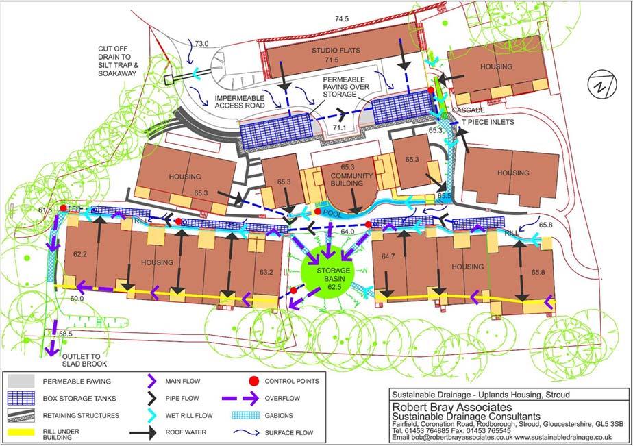
2 15th October 2013 Landform Event Page 3 HR Wallingford 2013 The Aim of SuDS. Page 4 HR Wallingford 2013 Bridget Woods Ballard HR Wallingford 2


3 The Aim of SuDS 15th October 2013 Landform Event Page 5 HR Wallingford 2013 The greenfield baseline Rainfall 40% evapotranspiration 10% runoff 25% deep infiltration 25% shallow infiltration Recharge groundwater Support river baseflow Page 6 Bridget Woods Ballard HR Wallingford 3


4 The development challenge Rainfall <30% evapotranspiration >55% runoff 10% shallow infiltration 5% deep infiltration Page 7 The dense urban challenge Rainfall >85% runoff? Page 8 Bridget Woods Ballard HR Wallingford 4
5 The National Standards Objective 1: Prioritise Infiltration in order to: Support flood risk management Control water pollution Protect water resources and river baseflows Page 9 Infiltration as a priority, unless: Low permeability Runoff destination Risk of geohazards Risk of groundwater contamination Not practicable Risk of surface water contamination Pumping required Hydraulic connectivity with combined sewer LFRMS precludes Not practicable Surface water body, unless: Surface water sewer, highway drain unless: Combined sewer Foul sewer Page 10 Bridget Woods Ballard HR Wallingford 5
6 The National Standards Objective 2: Mimic greenfield response characteristics in order to: Protect the ecology and morphology of the receiving waterbody Minimise the impact of the development on flood risk associated with the receiving waterbody Page No runoff from small events Nr of events > 50% Rainfall depths (mm) Page 12 Bridget Woods Ballard HR Wallingford 6


7 The hydrologic functions of streams change with as little as 5 10% imperviousness and they change profoundly when imperviousness approaches 25%. Johnston, et al., 2006 Why? Eroded/incised channel Non functional floodplain Pollution Sedimentation Depressed water table, dry riparian soils Page 13 How do we do that? > Infiltration systems > Rainwater harvesting systems (provided regular demand) > Green roofs > Permeable pavements > Swales, filter strips, trenches > Detention basins Page 14 Bridget Woods Ballard HR Wallingford 7
8 2. Control peak flow rates Control 1 in 1 year to greenfield equivalent > 1 in 1 year event = approximately bank full (morphological control) Control 1 in 100 year to greenfield equivalent > 1 in 100 year event = extreme flood flow rate Page 15 Why? Runoff rates (l/s/ha) Return period (yrs) Page 16 Bridget Woods Ballard HR Wallingford 8


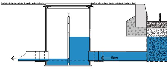

9 How do we do that? Qin Qin > Qout Attenuation storage Qout Page 17 Where can we do that? Page 18 Bridget Woods Ballard HR Wallingford 9


10 Where can you put storage? 15th October 2013 Landform Event Page 19 HR Wallingford 2013 Evidence Page 20 Bridget Woods Ballard HR Wallingford 10


11 3. Control volume of runoff Control 1 in 100 year runoff volume to the greenfield equivalent > 6 hour suggested as suitable event duration to reflect events that would impact on receiving catchment response Page 21 Why? Page 22 Bridget Woods Ballard HR Wallingford 11
 Some areas may be allowed to flood at lower return periods than others")
12 How? Long Term Storage = Development runoff volume Greenfield runoff volume (for 100 year, 6 hour event) Page Designing for exceedance Manage risks from events that exceed the system design capacity (people, property, the environment) Some areas may be allowed to flood at lower return periods than others depending on use etc For example: You may elect to flood landscape areas during period of extreme rainfall Or protect landscape areas but route exceedance flows to designated site storage facilities Roads / car park areas could be allowed to flood during extreme events Take account of benefits of multi functionality in delivering development value and viability 15th October 2013 Landform Event Page 24 HR Wallingford 2013 Bridget Woods Ballard HR Wallingford 12

13 > Simple, feasibility level Tools to help you > Greenfield runoff rate estimation > Storage volume estimation > RWH design for stormwater control > Site evaluation > Costing. (later) Updated EA report: RF-RO management for new developments W5-074 Page 25 Page 26 Bridget Woods Ballard HR Wallingford 13


14 Page 27 Page 28 Bridget Woods Ballard HR Wallingford 14

15 Thank you 15th October 2013 Landform Event Page 29 HR Wallingford 2013 Bridget Woods Ballard HR Wallingford 15
VI. ALTERNATIVES TO THE MASTER PLAN C. RENOVATED EAST BUILDING ALTERNATIVE
 VI. ALTERNATIVES TO THE MASTER PLAN C. RENOVATED EAST BUILDING ALTERNATIVE INTRODUCTION The Renovated East Building Alternative would include the continued use of the renovated West Building and the renovation
Presentation Outline
 Current Status and Future of Urban Stormwater Management on Wastewater System in Japan Takashi Sakakibara Infrastructure Management, Japan 2010 Water Korea 1 Presentation Outline Current Status Increase
4. Hydrology of the Olentangy River Watershed
 4. Hydrology of the Olentangy River Watershed The Hydrologic Cycle Water on Planet Earth is dynamic constantly being recycled from the land to the atmosphere to the ocean. Rivers and streams are just a
Colombia (South America) Water use and drainage in Colombia. Case Study: The Stormwater Challenge in Barranquilla. Humberto Avila.
 Water use and drainage in Colombia. Case Study: The Stormwater Challenge in Barranquilla. Humberto Avila.") Colombia (South America) Water use and drainage in Colombia Location: Case Study: The Stormwater Challenge in Barranquilla Source: Wikipedia The University of Alabama February 25, 2008 Population: 45 million
Colombia (South America) Water use and drainage in Colombia Location: Case Study: The Stormwater Challenge in Barranquilla Source: Wikipedia The University of Alabama February 25, 2008 Population: 45 million
Waukegan & Calumet Rivers. All Hands Meeting
 Waukegan & Calumet Rivers 516(e) Update All Hands Meeting David F. Bucaro, P.E. Chief, Economic Formulation & Analysis Section, Planning Branch May 18 th, 2011 Kensington Court Ann Arbor, MI 1 2 Waukegan
A303. Sparkford to Ilchester Dualling Scheme. Public consultation. Welcome. Highways England -- creative MCR18_0016
 Sparkford to Ilchester Dualling Scheme Public consultation Welcome Background The /A358 corridor provides vital east-west connectivity between the south west and London and the south east for people, communities
Conservation of Critical Environmental Resources in Chatham Park
 Conservation of Critical Environmental Resources in Chatham Park Elaine Chiosso, Haw Riverkeeper Haw River Assembly Haw River As Seen From Chatham Park "Spreading southwestward from the banks of the Haw
Geoscape Toronto The Oak Ridges Moraine Activity 2 - Page 1 of 10 Information Bulletin
 About 13,000 years ago as the Laurentide Ice Sheet melted, glacial meltwater accumulated between the ice sheet and the Niagara Escarpment. This formed a lake basin into which gravel and sand were deposited.
3.0 OVERVIEW OF HUECO BOLSON
 3.0 OVERVIEW OF HUECO BOLSON The Hueco Bolson covers about 2,500 square miles, or 1.6 million acres in New Mexico, Texas, and Chihuahua (Figure 3-1). In Texas, the Hueco overlies portions of El Paso and
PORTISHEAD BRANCH LINE PRELIMINARY ENVIRONMENTAL INFORMATION REPORT VOLUME 4 APPENDIX Water Receptors
 PORTISHEAD BRANCH LINE PRELIMINARY ENVIRONMENTAL INFORMATION REPORT APPENDIX 17. 3 Water Receptors Contents Section Page 1 Water Receptors... 1-1 1.1 Surface Water Features/Receptors in the Study Area
ETOBICOKE CREEK NORTH TRAIL PROJECT. May 18, 2017 at Michael Power High School 105 Eringate Drive, Etobicoke ON M9C 3Z7
 ETOBICOKE CREEK NORTH TRAIL PROJECT May 18, 2017 at Michael Power High School 105 Eringate Drive, Etobicoke ON M9C 3Z7 1 Purpose of Open House The purpose of today s open house is to present the design
Introduction. The System. Model Limitations, Assumptions, and Parameters. Optional Services Tech Memo
 Optional Services Tech Memo Introduction This technical memo evaluates the impact of a tide gate to be installed at the confluence of the Left Bank Tributary of Thalia Creek and Lake Windsor. Specifically,
Cau River. Map of River. Table of Basic Data. Vietnam 5
 Cau River Map of River Table of Basic Data Name: Cau River Location: Thai Nguyen, Province, Viet Nam Area: 6,030 km 2 Origin: Mt. Phia Deng 1,527 m Outlet: Pha Lai Note: * Indicates missing data in some
Managing water supply resources in karstic environment (temperate climate)
") UNESCO WORKSHOP Integrated Urban Water Management in TC Temperate Climates Belgrade 15-16 May 2006 Managing water supply resources in karstic environment (temperate climate) E. Rozos, D. Koutsoyiannis
UNESCO WORKSHOP Integrated Urban Water Management in TC Temperate Climates Belgrade 15-16 May 2006 Managing water supply resources in karstic environment (temperate climate) E. Rozos, D. Koutsoyiannis
Case Study: 1. The Clarence River Catchment
 Case Study: 1. The Clarence River Catchment The NSW coastline is a great natural asset, making an enormous contribution to the economy. The resources of coastal catchments such as the Clarence River Catchment,
II. THE BOULDER CREEK DRAINAGE BASIN
 II. THE BOULDER CREEK DRAINAGE BASIN This section provides an overview of the watersheds and flood hazards associated with Boulder Creek and South Boulder Creek including descriptions of the drainage basins,
SUTTER COUNTY. General Plan Update Technical Background Report
 SUTTER COUNTY General Plan Update Technical Background Report February 2008 SUTTER COUNTY GENERAL PLAN UPDATE TECHNICAL BACKGROUND REPORT PREPARED FOR: SUTTER COUNTY PREPARED BY: PBS&J IN PARTNERSHIP
Composite CN Value Based on Hydrologic Soil Group and Estimated Future Land Cover
 Composite CN Value Based on Hydrologic Soil Group and Estimated Future Land Cover Village of Milan, Mirabal Park /5/016 DEVELOPED LAND AREAS** Basin Basin HSG "B" HSG "C" HSG "D" Basin Basin Area Area
Statistical Evaluation of BMP Effectiveness in Reducing Fecal Coliform Impairment in Mermentau River Basin
 Statistical Evaluation of BMP Effectiveness in Reducing Fecal Coliform Impairment in Mermentau River Basin Z.-Q. Deng 1 and H. Chowdhary 2 1 Assistant Professor, Department of Civil and Environmental Engineering,
Thirteenth International Water Technology Conference, IWTC , Hurghada, Egypt 1249
 Thirteenth International Water Technology Conference, IWTC 13 2009, Hurghada, Egypt 1249 EVALUATION OF LOCAL SCOUR AROUND BRIDGE PIERS (RIVER NILE BRIDGES AS CASE STUDY) Sherine Ismail Assoc. Prof., Survey
Installing a Drainage Chimney. Written by Nevin Sunday, 28 May :35 - Last Updated Tuesday, 18 July :52
 Many, many years ago when we put the first tanks on the back of the garage, the council inspector had said that I needed to put in a rubble drain to take the stormwater from the roof of the garage. This
Glaciology. Water. Glacier. Moraine. Types of glacier-dammed lakes. Mechanics of jökulhlaup
 A Jökulhlaup Jökulhlaup. Catastrophic events where large amounts of water are suddenly discharged. Jökulhlaup s are a sudden and rapid draining of a glacier dammed lake or of water impounded within a glacier.
Rainfall Appendix. Summary Statistics of Rainfall Data for Sites in the West-Central Florida. A Simple Conceptualized Rainfall/Discharge Relationship
 Rainfall Appendix Summary Statistics of Rainfall Data for Sites in the West-Central Florida A Simple Conceptualized Rainfall/Discharge Relationship Stream or river flows are, of course, integrally associated
The Evolution of DFW Airport s Deicing Program Balancing Risks with Results MAY 20, 2015
 Dallas/Fort Worth International Airport The Evolution of DFW Airport s Deicing Program Balancing Risks with Results MAY 20, 2015 DFW: Connecting The World The cities of Dallas and Fort Worth overcame politics
Welcome KROSNO CREEK DIVERSION PROJECT CLASS ENVIRONMENTAL ASSESSMENT
 Welcome KROSNO CREEK DIVERSION PROJECT PUBLIC INFORMATION CENTRE # 1 Tonight s Presentation Study Overview Background Existing Conditions Alternative Solutions Preliminary Preferred Solution Next Steps
Groundwater Recharge/Discharge Y 1, 2, 3, 4, 5, 16 X Wetland appears to be a contiguous hydraulic system, draining towards Goff Mill Brook.
 Wetland Function-Value Evaluation Form Total area of wetland: Human made? No Is wetland part of a wildlife corridor? Yes or a habitat island? Adjacent land use Rt. 1, Commercial, undeveloped forest Distance
Public Works Research Institute
 Public Works Research Institute INTERNATIONAL WORKSHOP ON WATER HAZARD AND RISK MANAGEMENT SOME EXPERIENCES OF FLOOD MANAGEMENT IN ARGENTINA VÍCTOR POCHAT National Director for Water Policies,Coordination
MINUTES NAVAL WEAPONS STATION (NAVWPNSTA) SEAL BEACH RESTORATION ADVISORY BOARD (RAB) AND COMMUNITY MEETING March 8, 2005
 SEAL BEACH RESTORATION ADVISORY BOARD (RAB) AND COMMUNITY MEETING March 8, 2005") MINUTES NAVAL WEAPONS STATION (NAVWPNSTA) SEAL BEACH RESTORATION ADVISORY BOARD (RAB) AND COMMUNITY MEETING March 8, 2005 Participants: Blake, Geoffrey Carmody, Jack Chauvel, Tim / Department of Toxic
MINUTES NAVAL WEAPONS STATION (NAVWPNSTA) SEAL BEACH RESTORATION ADVISORY BOARD (RAB) AND COMMUNITY MEETING March 8, 2005 Participants: Blake, Geoffrey Carmody, Jack Chauvel, Tim / Department of Toxic
Paso Robles Groundwater Basin: Effects of Geothermal Waters on Water Quality and Availability
 Paso Robles Groundwater Basin: Effects of Geothermal Waters on Water Quality and Availability Jim Rytuba and Daniel Goldstein U.S. Geological Survey, Menlo Park, CA Paso Robles Intake from Lake Nacimiento
Long term morphological analysis and simulations
 Long term morphological analysis and simulations Dr.-Ing. Markus Promny Bundesanstalt für Gewässerkunde / Federal Institute of Hydrology GESINUS 2010 - Liège - 29./30.07.2010 page 1 1D-models of German
SUPPORT TO WATER RESOURCES MANAGEMENT IN THE DRINA RIVER BASIN DRAFT ROOF REPORT INTRODUCTION AND GENERAL APPROACH
 SUPPORT TO WATER RESOURCES MANAGEMENT IN THE DRINA RIVER BASIN DRAFT ROOF REPORT INTRODUCTION AND GENERAL APPROACH Nadja Zeleznik, REC Public Concultation Beograd, Serbia, 4 July 2017 1 1. Introduction
Hydrological processes on large flatlands: case study in the northwest region of Buenos Aires Province (Argentina)
") Remote Sensing and Hydrology 2000 (Proceedings of a symposium held at Santa Fe, New Mexico, USA, April 2000). IAHS Publ. no. 267, 2001. 531 Hydrological processes on large flatlands: case study in the
Remote Sensing and Hydrology 2000 (Proceedings of a symposium held at Santa Fe, New Mexico, USA, April 2000). IAHS Publ. no. 267, 2001. 531 Hydrological processes on large flatlands: case study in the
The north half of Section 18, Township 37 North, Range 6 East, Second Principal Meridian, Jefferson Township, Elkhart County, Indiana; also,
 The north half of Section 18, Township 37 North, Range 6 East, Second Principal Meridian, Jefferson Township, Elkhart County, Indiana; also, The east half of Sections 21, 28, and 33, Township 37 North,
Appendix A Appendix A (Project Specifications) Auk Auk / Black Diamond (Trail 44) Reroute
 Auk Auk / Black Diamond (Trail 44) Reroute") Appendix A (Project Specifications) Auk Auk / Black Diamond (Trail 44) Reroute I. Proposed Action: This project proposes to reroute approximately 1,800 feet of a 50 inch wide trail, off of private property
Appendix A (Project Specifications) Auk Auk / Black Diamond (Trail 44) Reroute I. Proposed Action: This project proposes to reroute approximately 1,800 feet of a 50 inch wide trail, off of private property
Brevard County Utility Services Department
 Brevard County Utility Services Department April 3, 2018 Jim Helmer, Department Director Brian Sorensen, W/WW Manager 1 Utility Services Department 9 TREATMENT PLANTS 6 WASTEWATER, 3 WATER 163 EMPLOYEES
Natural Factors Affecting the Level of Osoyoos Lake
 Natural Factors Affecting the Level of Osoyoos Lake Background Osoyoos Lake is operated under conditions prescribed by the International Joint Commission (IJC) and Figure 1 shows the ranges within which
EAST DON TRAIL ENVIRONMENTAL ASSESSMENT. Community Liaison Committee Meeting #3 July 15, :30 to 8:30 pm Flemingdon Park Library
 EAST DON TRAIL ENVIRONMENTAL ASSESSMENT Community Liaison Committee Meeting #3 July 15, 2013 6:30 to 8:30 pm Flemingdon Park Library Agenda 1. Welcome 2. Housekeeping and Updates a) Housekeeping b) CLC
Water resource situation of the Republic of Djibouti
 Water resource situation of the Republic of Djibouti Omar ASSOWE DABAR Integrating Groundwater Management within River Basins 15-17 January 2019 Nairobi, Kenya Regional Training Workshop on Introduction
ES Aircraft Deicing Document Identification Number Date: March 15, ) Activity Description:
 Activity Description:") ES-301-1.06 Aircraft Deicing Document Identification Number ES-301-1.06 Date: March 15, 2018 Document Owner: Keith Pass 1) Activity Description: Aircraft deicing is the application of aircraft deicing
ES-301-1.06 Aircraft Deicing Document Identification Number ES-301-1.06 Date: March 15, 2018 Document Owner: Keith Pass 1) Activity Description: Aircraft deicing is the application of aircraft deicing
port of brisbane Information Guide
 port of brisbane Information Guide A B O U T U S The Port of Brisbane, managed by the Port of Brisbane Pty Ltd, is Queensland s largest general cargo and container port, and a driver of economic growth
DEPARTMENT OF NATURAL RESOURCE PROTECTION TECHNICAL REPORT SERIES TR: 95-02
 DEPARTMENT OF NATURAL RESOURCE PROTECTION TECHNICAL REPORT SERIES TR: 95-02 SUMMARY OF BACTERIOLOGICAL TESTING IN THE LAS OLAS ISLES AUGUST 1994 THROUGH AUGUST 1995 ENVIRONMENTAL MONITORING DIVISION WATER
Hydrology of Recent Flooding in South East Queensland
 Hydrology of Recent Flooding in South East Queensland G. Hausler TOPICS Prelude eu e Rainfalls Catchments Flooding Aftermath Prelude Sea Surface Temperature anomalies for December 2010 Most likely return
Appendix 3. Greenway Design Standards. The Whitemarsh Township Greenway Plan
 Appendix 3 Greenway Design Standards This chapter discusses two design standards for the greenway types discussed above. First, trail design standards are presented together with trailhead facilities and
Agenda Report. Spruce Street Outlet Drainage Improvements Tower Road Relief Sewer
 Agenda Report Subject: Prepared By: Spruce Street Outlet Drainage Improvements Tower Road Relief Sewer Steven M. Saunders, Director of Public Works/Village Engineer Date: August 12, 2012 On March 8, 2012
The Danube Experience
 The Danube Experience Dealing with Hydromorphological Issues the Danube Experience Philip Weller Executive Secretary, ICPDR Danube River Basin- Overview The Danube River Basin is the most international
Recent Erosion and Mass Wasting Observed in Sunset Cliffs Natural Park. Craig Barilotti and Camilla Ingram Sunset Cliffs Association
 Recent Erosion and Mass Wasting Observed in Sunset Cliffs Natural Park Craig Barilotti and Camilla Ingram Sunset Cliffs Association 15 February 2011 Executive Summary A major source of nearshore pollution
HYDRAULIC DESIGN OF THE TOURISTIC BERTHING IN ASWAN CITY
 HYDRAULIC DESIGN OF THE TOURISTIC BERTHING IN ASWAN CITY Dr. Hossam El-Sersawy Researcher, Nile Research Institute (NRI), National Water Research Center (NWRC), Egypt E-mail: h_sersawy@hotmail.com Dr.
Permeable RECREATIONAL TRAILS
 SMART EARTH SOLUTIONS Permeable RECREATIONAL TRAILS GEOWEB GEOPAVE GEOTERRA Innovative Solutions for Designing & Building Trails. Trail Surface Stabilization The key to planning and building trails into
Ditch flows slowly to the north
 Ditch flows slowly to the north Photo 1. Wetland DE: Looking west across Wetland DE from upslope. Ponded water, mucky mineral soils, and patches of emergent vegetation observed. Wetland DE appears to be
Town of Danvers Planning Board
 Town of Danvers Planning Board Danvers Town Hall One Sylvan Street Danvers, MA 01923 www.danvers.govoffice.com Margaret Zilinsky, Chair Kristine Cheetham William Prentiss Aaron Henry James Sears John Farmer,
Hydrological study for the operation of Aposelemis reservoir Extended abstract
 Hydrological study for the operation of Aposelemis Extended abstract Scope and contents of the study The scope of the study was the analytic and systematic approach of the Aposelemis operation, based on
A brief explanation of what Grey Water is and how it can be recycled.
 A brief explanation of what Grey Water is and how it can be recycled. Madera County Code Chapter 13.55 WATER CONSERVATION Sections: 13.55.010 Purpose of regulations The board of supervisors of the county
Final Drainage Letter Pikes Peak Community College Downtown Parking Lot Colorado Springs, Colorado
 Final Drainage Letter Pikes Peak Community College Downtown Parking Lot Colorado Springs, Colorado Prepared for: Pikes Peak Community College 5775 South Academy Boulevard Colorado Springs, CO 80906-5422
Jeneberang River. Serial No. : Indonesia-10 Location: South Sulawesi Area: 727 km 2 Origin: Mt. Bawakaraeng (2,833 MSL) Outlet: Makassar Strait
 Outlet: Makassar Strait") Jeneberang River Map of River Table of Basic Data Name: Jeneberang River Serial No. : Indonesia-10 Location: South Sulawesi S 5 10' 00" - 5 26' 00" E 119 23' 50" - 119 56' 10" Area: 727 km 2 Origin: Mt.
Jeneberang River Map of River Table of Basic Data Name: Jeneberang River Serial No. : Indonesia-10 Location: South Sulawesi S 5 10' 00" - 5 26' 00" E 119 23' 50" - 119 56' 10" Area: 727 km 2 Origin: Mt.
The Casco Bay Estuary Partnership (CBEP, formerly the Casco
 The Casco Bay Estuary Partnership The Casco Bay Estuary Partnership (CBEP, formerly the Casco Bay Estuary Project) is a collaborative effort to preserve and protect the bay s resources. The partners include
When the preventative evacuation of Orléans can be decided on before a flood?
 When the preventative evacuation of Orléans can be decided on before a flood? GOUTX David (et al.) Loire flood-forecasting service 1/25 Major floods: a major issue for the Loire valley 2/25 Major floods:
A pilot flood retention area in La Bassée
 A pilot flood retention area in La Bassée Institution interdépartementale des barrages-réservoirs du bassin de la Seine 8, rue Villiot - 75012 Paris - Tél. : 01 44 75 29 29 - Télécopie : 01 44 75 29 30
LYNDHURST NEW URBAN DEVELOPMENT AREA STRUCTURE PLAN. Lyndhurst New Urban Development Area Structure Plan OUTCOMES AND PERFORMANCE STANDARDS
 APPENDIX 15.1-3 LYNDHURST NEW URBAN DEVELOPMENT AREA STRUCTURE PLAN Purpose of the Structure Plan Lyndhurst New Urban Development Area Structure Plan OUTCOMES AND PERFORMANCE STANDARDS LSP-P1 The District
"Transboundary coordination according to the FD Directive in the shared river basins of Greece
 Workshop on Transboundary Issues Budapest March 31st April 1st "Transboundary coordination according to the FD Directive in the shared river basins of Greece Katerina Triantafyllou, ECOS Consulting S.A.
Treats 2,271,000 gallons of greywater from the water park using the constructed lagoon and wetland, saving $8,539 in sewer charges annually.
 Carmel, IN Methodology for Landscape Performance Benefits Prepared by: Research Fellow: M. Elen Deming, Professor, University of Illinois Research Assistant: Paul Littleton, MLA Candidate, University of
Specification for Grip blocking using Peat Dams
 Technical Guidance Note 1 Specification for Grip blocking using Peat Dams 1. Introduction Moorland drains (grips) have been dug across much of the Yorkshire upland peatlands. Many of these grips have become
Review of the State of Knowledge for the Waterloo and Paris/Galt Moraines
 Review of the State of Knowledge for the Waterloo and Paris/Galt Moraines February 2009 Prepared for: Land and Water Policy Branch Ministry of the Environment Prepared by: Blackport Hydrogeology Inc. Blackport
Actual Climatic Conditions in ERB. Online Resource 1 corresponding to:
 Actual Climatic Conditions in ERB. Online Resource 1 corresponding to: Article Title: Climatic Trends and Impact of Climate Change on Agriculture in an Arid Andean Valley. Journal Name: CLIMATIC CHANGE
MANAGING FRESHWATER INFLOWS TO ESTUARIES
 MANAGING FRESHWATER INFLOWS TO ESTUARIES Yuna River Hydrologic Characterization A. Warner Warner, A. (2005). Yuna River Hydrologic Characterization. University Park, Pennsylvania: The Nature Conservancy.
STUDY OF ALAQI SECONDARY CHANNEL IN LAKE NASSER
 ABSTRACT STUDY OF ALAQI SECONDARY CHANNEL IN LAKE NASSER GamalSallam 1, Mohamed Ihab 2, and Waleed Emary 3 Associate Professor, National Water Research Center, Email: gasallam@yahoo.com Civil Engineer,
Some Historical Aspects of Urban Water Systems
 Some Historical Aspects of Urban Water Systems Robert Pitt Department of Civil and Environmental Engineering University of Alabama Tuscaloosa, AL 35487 Ancient springs at Delphi, Greece (site of Oracle)
FECAL COLIFORM MONITORING IN GRAYS HARBOR COUNTY: SUMMARY REPORT OF MONITORING RESULTS FOR
 Chehalis Basin Partnership Fecal Coliform Monitoring in Grays Harbor County: Summary Report of Monitoring Results for 2000-2003 Draft June 30, 2003 Prepared by Tetra Tech/KCM, Inc. 1917 First Avenue, Seattle,
HISTORICAL FLOOD LEVELS
 5.36 5.02 3.58 3.59 3.68 3.67 3.21 2.87 3.01 2.91 2.8 3.78 2.42 4.02 2.4 2.37 2.35 2.06 2.41 2.39 2.39 2.37 2.39 2.4 2.39 2.14 2.06 2.39 2.41 2.42 2.31 2.14 2.3 1.5 2.38 2.16 2.43 1.5 2.43 1.91 4.93 4.63
Monifieth (Potentially Vulnerable Area 07/10) Local Plan District Local authority Main catchment Tay Estuary and Montrose Angus Council, Dundee coasta
 Local Plan District Local authority Main catchment Tay Estuary and Montrose Angus Council, Dundee coasta") Monifieth (Potentially Vulnerable Area 07/10) Local Plan District Tay Estuary and Montrose Basin Local authority Angus Council, Dundee City Council Main catchment Dundee coastal Summary of flooding impacts
Monifieth (Potentially Vulnerable Area 07/10) Local Plan District Tay Estuary and Montrose Basin Local authority Angus Council, Dundee City Council Main catchment Dundee coastal Summary of flooding impacts
An experimental habitat enhancement effort for a sandy river: San Rafael River restoration project
 An experimental habitat enhancement effort for a sandy river: San Rafael River restoration project Samuel Lyster Department of Watershed Sciences, Utah State University Brian G. Laub Department of Watershed
Content: 1. Brief overview of CSI Ingenieros, and the water area Our clients Know how and solutions The team
 1 DIFFERENT CASES APPLIED IN Content: 1. Brief overview of CSI Ingenieros, and the water area Our clients Know how and solutions The team 2. Different Stormwater projects URUGUAY 3. Carrasco Hydrodynamic
CITY OF LYNDEN STORMWATER MANAGEMENT PROGRAM REPORT MARCH 1, 2016
 CITY OF LYNDEN STORMWATER MANAGEMENT PROGRAM 2015 WATER QUALITY MONITORING REPORT CITY OF LYNDEN 300 4 TH STREET LYNDEN, WASHINGTON 98264 PHONE (360) 354-3446 MARCH 1, 2016 This document serves as an attachment
Chapter 4.0 Alternatives Analysis
 Chapter 4.0 Alternatives Analysis Chapter 1 accumulated the baseline of existing airport data, Chapter 2 presented the outlook for the future in terms of operational activity, Chapter 3 defined the facilities
LESOTHO HIGHLANDS DEVELOPMENT AUTHORITY
 LESOTHO HIGHLANDS DEVELOPMENT AUTHORITY ANNUAL FLOW RELEASES INSTREAM FLOW REQUIREMENT (IFR) IMPLEMENTATION AND MONITORING (October 2004 to September 2005) TOWER ON MALIBAMATŠO RIVER @ KAO REPORT N0.6
UNIT 5 PHYSICAL GEOGRAPHY SG 1 - PART I
 UNIT 5 PHYSICAL GEOGRAPHY SG 1 - PART I Africa is HUGE! I. LANDFORMS A. Plateaus - an area of relatively level high ground. 1. Africa s interior is dominated by series of plateaus and elevated basins such
AN OUTLINE OF THE NILE BASIN
 The Hydrology of the Nile by J. V. Sutcliffe & Y. P. Parks. IAHS Special Publication no. 5, 1999. CHAPTER 1 AN OUTLINE OF THE NILE BASIN INTRODUCTION The hydrology of the Nile basin cannot be understood
Initial OPW Designation APSR AFRR IRR Co-ordinates Easting: Northing: River / Catchment / Sub-catchment Type of Flooding / Flood Risk
 Location: Shannon International Airport, Co. Clare Unique ID: 275484 (from PFRA database) Initial OPW Designation APSR AFRR IRR Co-ordinates Easting: 137674 Northing: 161045 River / Catchment / Sub-catchment
ASSESSMENT OF FECAL COLIFORM IN LITTLE RABBIT CREEK AND LITTLE SURVIVAL CREEK
 ASSESSMENT OF FECAL COLIFORM IN LITTLE RABBIT CREEK AND LITTLE SURVIVAL CREEK FINAL REPORT Prepared for: Alaska Department of Environmental Conservation 555 Cordova Street Anchorage, Alaska 99501 Prepared
Project Management, Environmental Assessment, Stormwater Management. Hydrologic Modelling. Natural Heritage. Fluvial Geomorphology
 Welcome PUBLIC INFORMATION CENTRE # 1 KROSNO CREEK DIVERSION PROJECT February 19, 2014 6:30 p.m. to 8:30 p.m. Please sign in on the sheet provided. Then feel free to walk around and view the displays.
Water resources cycle in karst (feasibility studies and engineering design; case studies)
") Water resources cycle in karst (feasibility studies and engineering design; case studies) Prof. emeritus Ognjen Bonacci Faculty of Civil Engineering, Architecture and Geodesy, Split University E-mail:
Water resources cycle in karst (feasibility studies and engineering design; case studies) Prof. emeritus Ognjen Bonacci Faculty of Civil Engineering, Architecture and Geodesy, Split University E-mail:
DROUGHT AND SCARCITY PLANS IN THE BRAVO RIVER BASIN
 DROUGHT AND SCARCITY PLANS IN THE BRAVO RIVER BASIN Sergio Soto-Priante Deputy Director General Sub Direction of Hydraulic Infrastructure for Agriculture National Water Commission (Mexico) February 2009.
Platte West Well Field A Protective Modeling Approach
 Platte West Well Field A Protective Modeling Approach Presented to: 2007 Eastern South Dakota Water Conference / 52 nd Annual Midwest Ground Water Conference June 25, 2007 Presented by: Luca DeAngelis,
AMENDMENT #230 TO THE OFFICIAL PLAN OF THE TOWNSHIP OF KING PLANNING AREA
 AMENDMENT #230 TO THE OFFICIAL PLAN OF THE TOWNSHIP OF KING PLANNING AREA Oak Ridges Moraine Conservation Plan Amendment to Township of King Official Plan Amendment #23 (Hamlet Secondary Plan) October
Presented to: City of Petaluma City Council
 Agenda Item #1.A REVISED Presented to: City of Petaluma City Council Presented By: Dan St. John, F.ASCE, Director Jason Beatty, P.E., Senior Engineer James 'Jody' Boyette, USACE Project Manager November
CorriPipe. Fittings & Accessories
 CorriPipe Fittings & Accessories CorriPipe JFC CorriPipe is a twinwall drainage pipe made from HDPE plastic and is manufactured by twin extrusion process in which the two layers are simultaneously extruded
Watershed Runoff Analysis
 CREATING SOLUTIONS FOR A CHANGING WORLD Watershed Runoff Analysis April 18, 2017 John Melack, UCSB Ed Beighley & Dongmei Feng, Northeastern University Study Workflow Civil and Environmental Engineering
Oro Moraine 2010 Report Card Prepared by: the NVCA & LSRCA on behalf of the Oro-Medonte Environmental Group Advisors
 Nottawasaga Valley Conservation Authority Oro Moraine Report Card General Information for Oro Moraine 2010 Report Card Prepared by: the NVCA & LSRCA on behalf of the Oro-Medonte Environmental Group Advisors
Prosjekt Lesina Mediteranean sea Coastal lagoon
 Prosjekt Lesina Mediteranean sea Coastal lagoon PERIODE 2012-2015 LAND The Lesina Lagoon, alternatively known as the Lake of Lesina due to its small and previously fleeting hydrological connection to the
Paul Sturm Roberto Viqueira Ríos
 Paul Sturm Roberto Viqueira Ríos In this talk Brief Background on Land Based Sources Historical Perspective Guánica watershed characteristics/ issues High priority restoration projects Other key issues
X. WHATCOM CREEK SMA. X.1 Watershed Analysis. X.1.1 Landscape Setting
 X. WHATCOM CREEK SMA Summary: The entire length of Whatcom Creek is located within the City of Bellingham. SMA jurisdiction associated with this creek is approximately 300 acres. Land use is dominated
Appendix A: San Francisco River Photos Gila National Forest
 Appendix A: San Francisco River Photos Gila National Forest These photos accompany our request for closure to demonstrate both the the outstanding ecological values associated with this area, as well as
International Sava River Basin Commission
 International Sava River Basin Commission Pilot project on climate change: Building the link between the Flood Risk Management planning and climate change assessment in the Sava River Basin climate change
River First Initiative and Waterworks Park
 River First Initiative and Waterworks Park The RiverFIRST proposal is critical to the creation of a larger regional parks and trails network, as well as ecological and infrastructure system. When realized,
Sandbag Barrier. Suitable Applications Sandbag barriers may be suitable: As a linear sediment control measure:
 Categories EC Erosion Control SE Sediment Control TC Tracking Control WE Wind Erosion Control Non-Stormwater NS Management Control Waste Management and WM Materials Pollution Control Legend: Primary Category
International Osoyoos Lake Board of Control Annual Report to the International Joint Commission
 International Osoyoos Lake Board of Control 2010 Annual Report to the International Joint Commission TABLE OF CONTENTS ACTIVITIES OF THE BOARD... 1 HYDROLOGIC CONDITIONS IN 2010... 2 Drought Criteria...
Pollution Incident Response Management Plan
 Baines Masonary Blocks Pty Ltd (Baines Masonry) 900 Wilton Rd, Appin, NSW 2560 Pollution Incident Response Management Plan Page 1 of 7 Table of Contents 1. Purpose and Scope 3 2. Process 3 3. Definition
Village of Lombard, Illinois Capital Improvement Plan FUNDING SOURCE SUMMARY
 Village of Lombard, Illinois Capital Improvement Plan FY 15 FY 24 thru FUNDING SOURCE SUMMARY Source FY 15 FY 16 FY 17 FY 18 FY 19 FY 20 FY 21 FY 22 FY 23 FY 24 Construction Fund 6,318,700 2,354,800 2,430,800
SLV POWER PRIVATE LIMITED ANIYUR MINI HYDEL SCHEME (3 X 8 MW = 24 MW) CATCHMENT AREA TREATMENT PLAN
 CATCHMENT AREA TREATMENT PLAN") SLV POWER PRIVATE LIMITED ANIYUR MINI HYDEL SCHEME (3 X 8 MW = 24 MW) CATCHMENT AREA TREATMENT PLAN 1. INTRODUCTION : M/s SLV Power Pvt. Ltd. Is setting up a Mini Hydel Scheme of 24 MW capacity across
SLV POWER PRIVATE LIMITED ANIYUR MINI HYDEL SCHEME (3 X 8 MW = 24 MW) CATCHMENT AREA TREATMENT PLAN 1. INTRODUCTION : M/s SLV Power Pvt. Ltd. Is setting up a Mini Hydel Scheme of 24 MW capacity across
Occurrence of Dry and Wet Periods in Altitudinal Vegetation Stages of West Carpathians in Slovakia: Time-Series Analysis
 Occurrence of Dry and Wet Periods in Altitudinal Vegetation Stages of West Carpathians in Slovakia: Time-Series Analysis 1951-2005 J. Hrvoľ,, J. J Škvarenina,, J. J Tomlain, J. Škvareninová,, P. Nejedlík
LAKELAND PAVERS North Lakes Industrial Park, Flusco, Penrith, Cumbria CA11 0JB Tel: Fax:
 LAKELAND PAVERS North Lakes Industrial Park, Flusco, Penrith, Cumbria CA11 0JB Tel: 017684 83617 Fax: 017684 83890 Email: sales@lakelandconcrete.co.uk www.lakelandconcrete.co.uk PAVING THE WAY TO A BETTER